TRAIL 4 North Bay
Mount Tamalpais: Middle Peak
TRAIL USE
Hike, Run, Dogs Allowed, Fee
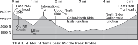
LENGTH
5.1 miles, 3 hours
VERTICAL FEET
±1450'
DIFFICULTY
– 1 2 3 4 5 +
TRAIL TYPE
Loop
SURFACE TYPE
Dirt, Paved
FEATURES
Fee
Stream
Canyon
Mountain
Birds
Great Views
Cool & Shady
FACILITIES
Visitor Center
Restrooms
Picnic Tables
Water
Phone
This circuit of Middle Peak explores a wonderful variety of terrain, from chaparral cloaking the mountain’s upper reaches to redwood groves hidden on its northern side. Along the way, you have fine views of Marin Municipal Water District (MMWD) lands, including Bon Tempe Lake and Lake Lagunitas.
Best Time
All year; expect fog in summer. In winter, if fog blankets the Bay Area, this trail may rise above it.
Finding the Trail
From US Hwy. 101 northbound in Mill Valley, take the State Hwy. 1/Mill Valley/Stinson Beach exit (which is also signed for Muir Woods and Mt. Tamalpais). After exiting, stay in the right lane as you go under Hwy. 101. At about 1 mile from Hwy. 101, get in the left lane, and, at a stoplight, follow Shoreline Hwy. as it turns left.
Continue 2.7 miles to Panoramic Hwy. and turn right. At 5.4 miles from Hwy. 1, you reach the Pantoll Campground and Ranger Station, left, and Pantoll Rd., right. Turn right, and go 1.4 miles to a T-junction with E. Ridgecrest Blvd. and W. Ridgecrest Blvd. Turn right on E. Ridgecrest Blvd. and go 3 miles to the East Peak parking area and a self-registration station, just below East Peak. The trailhead is on the east end of the East Peak parking area, just south of the visitor center and restrooms.
From Hwy. 101 southbound in Mill Valley, take the State Hwy. 1 N./Stinson Beach exit (which is also signed for Muir Woods and Mt. Tamalpais). After exiting, bear right, go 0.1 mile to a stop sign, and bear left on Hwy. 1. Go 0.5 mile, get in the left lane, and, at a stoplight, follow Shoreline Hwy. as it turns left. Then follow the directions in the previous paragraph.
Trail Description
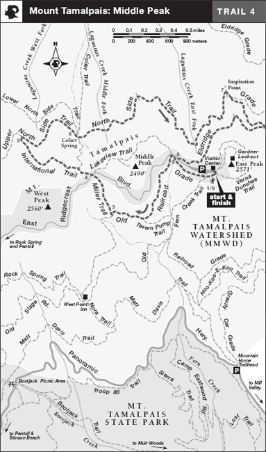
From the trailhead, 1 walk down a narrow paved road, closed to cars, that descends through chaparral below the south edge of the parking area. Several hundred yards from the start, you briefly join East Ridgecrest Boulevard, and pass Eldridge Grade, a dirt road, on your right. About 100 feet farther, you turn left onto Old Railroad Grade, a dirt road favored by mountain bikers.2
A sea of chaparral—manzanita, chamise, buckbrush, and toyon—blankets these upper reaches of the mountain. Soon you pass the Tavern Pump Trail, which heads left and steeply downhill. When you reach the Miller Trail,3 turn right and begin a moderate ascent through manzanita and clumps of native bunchgrass, aided in places by wood and stone steps. After a few steep sections, the Miller Trail arrives at East Ridgecrest Boulevard,4 which divides the north and south sides of the mountain.
 Mountain
 OPTIONS
Mount Tam’s East Peak
From the trailhead you can easily climb East Peak (2571') via the well-graded East Peak Trail, which starts off from the trailhead on a boardwalk just between the restrooms and the snack bar. The rustic fire lookout on the summit is staffed in summer.
After carefully crossing the paved road, find the International Trail heading northwest. Several hundred feet from the road, you reach a junction where the Colier Spring Trail, a shortcut to the North Side Trail, descends right. Your route continues straight through dense forest of Douglas-fir, tanbark oak, California bay, and California nutmeg, dropping in places to lose elevation, leveling in others.
On a rocky, open ridge studded with Sargent cypress, the International Trail ends at a junction with the Upper North Side Trail; here you turn right.5 The Upper North Side Trail traverses eastward through mixed evergreen forest on an easy grade, soon reaching a junction at Colier Spring in a coast redwood grove, where a rest bench awaits.6 From here continue straight, now on the gently rolling North Side Trail. Once past Lagunitas Creek Middle Fork, which flows under the trail through a culvert, you make a gentle climb through open stands of madrone and tanbark oak. At one ridge, your trail makes a sharp right-hand bend and crosses a closed fire trail. Middle Peak, topped by communication towers, is uphill and right.
 Stream
Continuing straight, the route crosses a culvert holding Lagunitas Creek East Fork, where waterfalls may tumble over mossy rocks just upstream. After passing a seasonal creek, the trail bends left, affording views of Pilot Knob and Bon Tempe Lake. Soon you reach Inspiration Point, a clearing marked by a trail post. Continue straight on the Northside Trail about 100 yards to meet Eldridge Grade, a dirt road, where you bear right.7
On a clear day you can see San Francisco, Angel Island, the Bay Bridge, the East Bay hills, the Marin Headlands, and the East, Middle, and West summits of Mt. Tamalpais.
The road heads eastward, only to reverse field with a sharp right-hand switchback. Now follow the road generally southwest, with the summit of East Peak slightly left and only a few hundred feet above. Eldridge Grade skirts the west side of East Peak, swings right, and soon makes a moderate climb to East Ridgecrest Boulevard. Here you turn left8 and retrace your route to the parking area.9
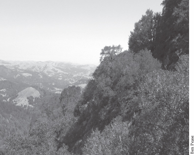
View north from Mt. Tam’s Middle Peak
 MILESTONES
Trail 4
1 0.0 Take closed paved road south and west
2 0.2 Merge with E. Ridgecrest Blvd., then left on Old Railroad Grade
3 0.8 Right on Miller Trail
4 1.1 Cross E. Ridgecrest Blvd., take International Trail
5 1.6 Right on Upper North Side Trail
6 2.1 Straight on North Side Trail
7 3.7 Right on Eldridge Grade
8 4.9 Left on E. Ridgecrest Blvd.
9 5.1 Back at parking area