TRAIL 41 Peninsula
Kings Mountain
TRAIL USE
Hike, Run
LENGTH
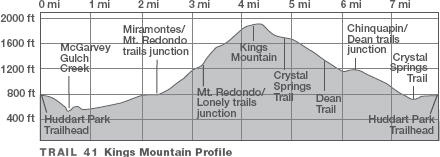
7.9 miles, 3–5 hours
VERTICAL FEET
±1500'
DIFFICULTY
– 1 2 3 4 5 +
TRAIL TYPE
Loop
SURFACE TYPE
Dirt
FEATURES
Fee
Stream
Canyon
Birds
Wildlife
Secluded
Cool & Shady
FACILITIES
Restrooms
Picnic Tables
Phone
Water
The contrast between Huddart County Park and its neighbor, Golden Gate National Recreation Area’s Phleger Estate, could not be more extreme. Trading picnic areas and sports fields for serene groves of coast redwoods, you struggle up Kings Mountain on the aptly-named Lonely Trail, then saunter down to civilization on Huddart’s well-graded equestrian trails.
Best Time
All year, but trails may be muddy in wet weather.
Finding the Trail
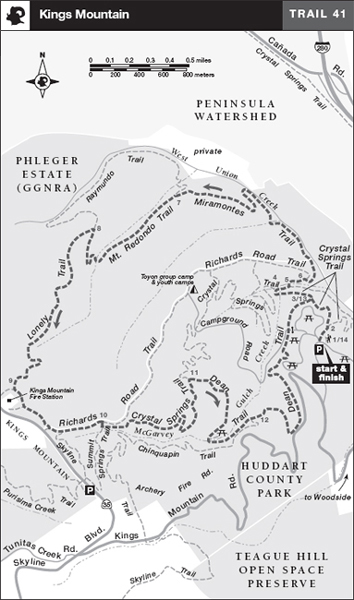
From Interstate 280 in Woodside, take the Woodside Rd./Woodside/State Hwy. 84 exit and go southwest 1.6 miles to Kings Mountain Rd. Turn right, go 2.1 miles to the Huddart Park entrance, and turn right. At 0.2 mile there is an entrance kiosk and self-registration station. There are parking areas on both sides of the road just ahead. The trailhead 1 is a few hundred feet north of the parking areas, on the east side of a paved road that is signed for Zwierlein, Werder, Madrone, and Miwok picnic areas.
Trail Description
The trailhead has information boards, a map holder, and water. You follow a single track that curves right and descends to a left-hand switchback amid stands of coast redwood, Douglas-fir, coast live oak, and tanbark oak. Soon the Bay Tree Trail departs sharply to the right, and you have a sports field, picnic area, and restrooms on your left. Now reach a junction with the Crystal Springs Trail,2 where you bear left and follow a rolling course. Soon you pass the Dean Trail, your return route, left.3
Now the trail descends on a gentle grade, via more switchbacks, into a canyon holding a seasonal tributary of West Union Creek, shown on the park map as McGarvey Gulch Creek. At the canyon bottom, the Crystal Springs Trail turns left across the creek,4 but you go right on a connector. Soon you merge with the Richards Road Trail and turn sharply left.5
Richards Road crosses McGarvey Gulch Creek via a culvert, then climbs to a junction6 where you veer right on the Miramontes Trail. The single-track trail gradually bends left and descends to West Union Creek, where you saunter through streamside groves of coast redwoods.
 Stream
After following the shady stream, the Miramontes Trail climbs via switchbacks to a junction.7 You continue straight, now on the single-track Mt. Redondo Trail, which climbs steadily, and sometimes steeply, beside a deep canyon, right.
 Steep
Steep
At the next junction, the Raymundo Trail goes straight and your route, the Lonely Trail, heads left.8 Ascending a ridge cloaked in toyon and tanbark oak, you begin to work your way across a canyon wall that drops steeply left. You are now high on the eastern flank of Kings Mountain, a long ridge extending from near State Highway 92 southeast to Bear Gulch Road.
 Secluded
After a brief respite, you resume a steady climb beside a deep ravine, left. The narrow trail perches on a steep hillside. Just below the Kings Mountain Fire Station, whose communication towers are just uphill, the Lonely Trail ends at an unsigned junction.9 Bear left and follow a rolling course parallel to Skyline Boulevard, one of California’s premier scenic roads. Stay left where another trail joins from the right.
At the boundary of Huddart County Park, angle left on the Richards Road Trail, a dirt road. After passing the Skyline Trail, right, turn right on the Summit Springs Trail.10 After about 100 feet, find the Crystal Springs Trail, left, and a rest bench. From here, follow the Crystal Springs Trail past a seasonal-closure gate that prevents access by horses during wet weather. The wide path descends gently along a ridge and then through forest. At a junction with the Dean Trail,11 turn sharply right and continue descending.
Just before reaching a bridge, you pass a spur to McGarvey Flat, a lovely spot with a picnic table and several rest benches hewn from logs. Continuing across McGarvey Gulch Creek, a gentle climb on an old road brings you to a junction with the Chinquapin Trail, right.12 Here veer left to stay on the Dean Trail, going straight through two crossings of Archery Fire Road ahead.
 HISTORY
More Phleger Trails
Explore the lower Phleger Estate property on this 6.9-mile semiloop: From the top of the Mt. Redondo Trail 8 stay right on the Raymundo Trail and then descend along redwood-lined West Union Creek to the junction of the Mt. Redondo and Miramontes trails.7 Return on the Miramontes, Richards Rd., and Crystal Springs trails to Huddart Park.
At the edge of a paved road near the Miwok picnic area, the Dean Trail turns sharply left and then begins a series of switchbacks, descending past the Madrone picnic area. Follow the Dean Trail, here a wide path, as it makes a curving descent past more picnic areas. At a T-junction with the Crystal Springs Trail,13 turn right and retrace your route to the parking area.14
 MILESTONES
Trail 41
1 0.0 Take single-track trail northeast; Bay Tree Trail on right
2 0.2 Left on Crystal Springs Trail
3 0.4 Dean Trail on left; straight to stay on Crystal Springs Trail
4 0.7 Right on connector to Richards Rd. Trail
5 0.8 Merge with Richards Rd. Trail, then left across creek
6 0.9 Right on Miramontes Trail
7 2.3 Straight on Mt. Redondo Trail
8 3.1 Left on Lonely Trail
9 4.1 Lonely Trail ends; bear left at unsigned junction below Kings Mountain Fire Station
10 4.9 Right on Summit Springs Trail, then left on Crystal Springs Trail
11 5.7 Sharply right on Dean Trail
12 6.3 Left at junction with Chinquapin Trail to stay on Dean Trail
13 7.5 Right at T-junction on Crystal Springs Trail, retrace to parking area
14 7.9 Back at parking area