TRAIL 6 North Bay
Samuel P. Taylor State Park: Barnabe Mountain
TRAIL USE
Hike, Run
LENGTH
6.5 miles, 4 hours
VERTICAL FEET
±1900'
DIFFICULTY
– 1 2 3 4 5 +
TRAIL TYPE
Loop
SURFACE TYPE
Dirt, Paved
FEATURES
Stream
Canyon
Mountain
Wildflowers
Birds
Great Views
Secluded
FACILITIES
None
This loop climbs gently through mixed forest, alive with birdsong and brightened by wildflowers, struggles steeply to high ground just below the summit of Barnabe Mountain (1466'), and then descends through open country with wonderful views of west Marin, Point Reyes, and the Tomales Bay area.
Best Time
All year, but trails may be muddy in wet weather.
Finding the Trail
From US Hwy. 101 northbound, take the San Anselmo exit (also signed for San Quentin, Sir Francis Drake Blvd., and the Richmond Bridge). Stay in the left lane as you exit, toward San Anselmo, crossing over Hwy. 101. After 0.4 mile you join Sir Francis Drake Blvd., with traffic from Hwy. 101 southbound merging on your right. From here, it is 3.6 miles to a stoplight at the intersection with Red Hill Ave. Stay on Sir Francis Drake Blvd. as it first goes straight and then immediately bends left.
At 15.5 miles on Sir Francis Drake Blvd., you pass the main entrance to Samuel P. Taylor State Park. At 16.5 miles you reach a wide turnout, left, opposite a sign reading DEVIL’S GULCH HORSE CAMP. Park here. The Devil’s Gulch trailhead is directly across Sir Francis Drake Blvd. 1
1
From US Hwy. 101 southbound, take the Sir Francis Drake/Kentfield exit and follow the directions above.
Enjoy the view from the park boundary atop Barnabe Mountain: Mt. Diablo (east), Mt. Tamalpais (southeast), Kent Lake (south), and Big Rock Ridge (northeast).
Trail Description
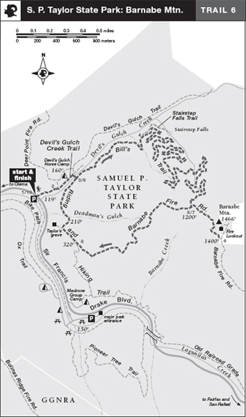
After carefully crossing Sir Francis Drake Boulevard, you follow a paved one-lane road that heads northeast beside Devil’s Gulch Creek. Turn right onto Devil’s Gulch Creek Trail,2 a single track that descends toward the creek, and follow it to a junction beneath an enormous coast redwood.3
Turn right and cross a long wooden bridge spanning the creek. Once across, you arrive at a T-junction. Your route, Bill’s Trail, heads left and begins a long, gentle climb. In 0.7 mile, you reach a junction with the Stairstep Falls Trail,4 left.
Bearing right from this junction, you climb across a steep hillside that falls away left, and then begin a long series of switchbacks. As you climb, the vegetation changes between shady stands of bigleaf maple, California bay, Douglas-fir, and California nutmeg. Sunlight illuminates weedy patches of poison hemlock, cow parsnip, Italian thistle, and blackberry tangles. Finally leaving the trees behind, you reach a superb vantage point, where the view extends west to the lands of Point Reyes National Seashore and northwest to Tomales Bay. Now you meet the Barnabe Fire Road.5 From here, turn left to continue your ascent of Barnabe Mountain.
 Great Views
 Mountain
After a leg-stretching climb across a steep, grassy slope dotted with coastal scrub, you reach a T-junction at the state-park boundary.6 From here, a dirt road goes left and uphill to a fire lookout, and also goes right along the ridge. (Please respect any private property postings.)
Retrace your route downhill on the Barnabe Fire Road past the junction with Bill’s Trail.7 From here, continue descending on this dirt road, initially steep but then moderate. Far down the mountain, you come to a junction with the Riding and Hiking Trail, on which you turn right.8
Ahead, a short path leads left to Taylor’s grave site, but your route, the Riding and Hiking Trail, bends right. Heading into forest, you follow a rough, eroded road steeply downhill into Deadman’s Gulch. Your route narrows, veers left, and skirts a grassy hillside. Now with Devil’s Gulch Creek downhill and left, you make a steep descent and soon reach the junction with Bill’s Trail and the wooden bridge you crossed at the start of this loop.9 Here you turn left, cross the bridge, turn left again, and retrace your route to the parking area. Look both ways before crossing the highway!10
 OPTIONS
Stairstep Falls
This slender cascade in a narrow, wooded cleft, is reached by the Stairstep Falls Trail. This easy, 0.2-mile spur trail descends across the hillside to a viewing area and rest bench at the foot of the falls. Retrace your steps, and continue up Bill’s Trail, from which the falls are sometimes audible but never seen.
Samuel P. Taylor (1827–1896) established the West Coast’s first paper mill nearby on the banks of Lagunitas Creek.
 MILESTONES
Trail 6
1 0.0 Take paved road northeast
2 0.1 Right on Devil’s Gulch Creek Trail
3 0.2 Right across bridge, then left on Bill’s Trail
4 0.9 Trail to Stairstep Falls, left
5 4.0 Left on Barnabe Fire Rd.
6 4.3 Park boundary near summit; retrace to previous junction
7 4.6 Bill’s Trail on right; go straight to stay on Barnabe Fire Rd.
8 5.8 Go right on Riding and Hiking Trail
9 6.3 Left across bridge, then retrace on Devil’s Gulch Trail
10 6.5 Back at parking area