TRAIL 7 North Bay
Point Reyes National Seashore: Sky Trail
TRAIL USE
Hike, Run
LENGTH
10.5 miles, 5–7 hours
VERTICAL FEET
±1650'
DIFFICULTY
– 1 2 3 4 5 +
TRAIL TYPE
Loop
SURFACE TYPE
Dirt
FEATURES
Stream
Autumn Colors
Wildflowers
Birds
Great Views
Cool & Shady
Camping
FACILITIES
Visitor Center
Restrooms
Picnic Tables
Water
Phone
This is one of the premier hikes in the Point Reyes area, offering a grand tour of Inverness Ridge and Bear Valley, with the Pacific shoreline thrown in for good measure. The route has something for everyone, including a wonderful array of plant and bird life, and fine views.
Best Time
This route is enjoyable all year.
Finding the Trail
From State Hwy. 1 northbound in Olema, just north of the junction with Sir Francis Drake Blvd., turn left on Bear Valley Rd. and go 0.5 mile to the visitor-center entrance road. Turn left and go 0.2 mile to a large paved parking area in front of the visitor center. If this lot is full, there is a dirt parking area ahead and left.
From Hwy. 1 southbound in Point Reyes Station, go 0.2 mile from the end of the town’s main street to Sir Francis Drake Blvd. and turn right. Go 0.7 mile and turn left onto Bear Valley Rd. At 1.7 miles you reach the visitor-center entrance road; turn right and follow the directions above.
The Bear Valley trailhead is at the end of the paved visitor-center entrance road, about 150 feet south of the paved parking area.
Trail Description
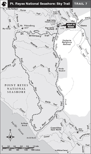
From the trailhead, 1 walk south on the Bear Valley Trail, a wide dirt road that skirts a broad grassland. When you reach the Mt. Wittenberg Trail,
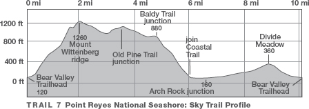
 2 turn right and begin to climb a single track through a dense forest of California bay. Occasional level stretches, some in small meadows, relieve the otherwise constant climbing.
Mt. Wittenberg is named for a rancher who once lived nearby, not for Hamlet’s alma mater.
Climbing out of the forest to a grassy saddle, 3 you pass the Z Ranch Trail and a short trail to Mt. Wittenberg’s tree-encircled, viewless summit, both right. As the Mt. Wittenberg Trail rambles down the far side of the saddle, there are fine views north and west across the Point Reyes peninsula. At a junction with the Sky Trail,
 4 join it by merging left. About 50 feet ahead, you pass the Meadow Trail on your left. Continue on the Sky Trail, enjoy a rolling course through a wonderful Douglas-fir forest.
 OPTIONS
Sky Camp
Sky Camp, a hike-in campground, is on the Sky Trail, northwest of its junction with the Mt. Wittenberg Trail. 4 For reservations, call (415) 663-8054 weekdays from 9 A.M. to 2 P.M. Reservations for campsites at Point Reyes can fill up quickly, so you might want to plan ahead.


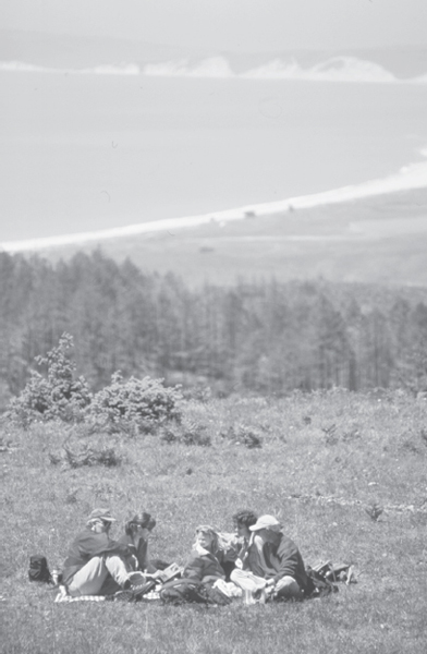
Sky Trail offers dramatic views of Drakes Bay and Point Reyes.
 Wildflowers
As you tromp along the trail, you may scare up a covey of California quail, birds that run and hide to avoid predators, taking flight only as a last resort. From a small clearing, the Woodward Valley Trail heads right, but you continue straight. Next, you pass the Old Pine Trail, left. 5 About 0.8 mile ahead, you emerge from forest and negotiate a moderate descent across a grassy knoll. Passing the Baldy Trail,
 6 left, you enter a zone of coastal scrub, where shrubs such as California sagebrush, coyote brush, poison oak, bush monkeyflower, and silver lupine thrive.
Now the route drops through forest and across a grassy slope. Angle slightly left on the Coast Trail, 7 a dirt road along the coastal terrace. Eventually the road swings left into the canyon of Coast Creek and you arrive at a junction where the Coast Trail and the spur for Arch Rock turn sharply right.
 8
8
 Stream
From the Arch Rock junction, continue straight on the Bear Valley Trail, a dirt road often crowded with hikers. Coast Creek flows vigorously year-round to your right, screened by stands of Douglas-fir, bay, red alder, and California buckeye. About a mile inland, you pass the Baldy Trail on the left and the Glen Trail on the right. From here on, this busy trail is open to bicyclists and (on weekdays) to horses.
 Cool and Shady
Continuing beside Coast Creek, you ascend gradually to Divide Meadow, 9 where there are restrooms and a junction with the Old Pine Trail, both left. The Bear Valley Trail now descends past the headwaters of Bear Valley Creek. A rest bench signals a junction with the Meadow Trail. You emerge from the wooded canyon at the junction with the Mt. Wittenberg Trail; continue straight on the Bear Valley Trail and retrace your route to the parking area.
 10
10
 OPTIONS
Shorter Loops and Arch Rock
Along the Sky Trail you can turn left on either the Meadow, Old Pine, or Baldy trails and then left on the Bear Valley Trail. The round-trip distances are then 4.7 miles, 6.9 miles, and 9 miles, respectively.
 8 Visit Arch Rock during the spring wildflower bloom for great photos! This side trip adds 0.6 mile to the described route.

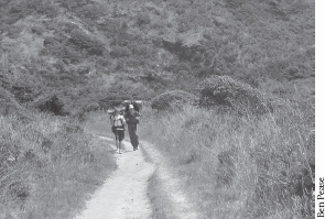
Backpackers on the Coast Trail
 MILESTONES
Trail 7
 1 0.0 Take Bear Valley Trail south
 2 0.2 Right on Mt. Wittenberg Trail
 3 2.0 Veer left at junction with trail to Mt. Wittenberg summit
 4 2.4 Merge with Sky Trail; Meadow Trail on left
 5 3.4 Old Pine Trail on left; go straight on Sky Trail
 6 4.8 Baldy Trail on left; go straight on Sky Trail
 7 6.0 Left on Coast Trail
 8 6.5 Coast Trail and side trail to Arch Rock on right; continue straight on Bear Valley Trail
 9 8.9 Ascend Divide Meadow; go straight, and pass Old Pine Trail on left
 10 10.5 Back at parking area