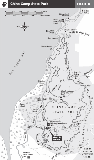
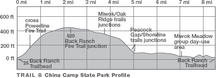
TRAIL 8 North Bay
China Camp State Park: Bay View–Shoreline Loop
TRAIL USE
Hike, Run, Bike
LENGTH
8.4 miles, 4–5 hours
VERTICAL FEET
±1450'
DIFFICULTY
– 1 2 3 4 5 +
TRAIL TYPE
Loop
SURFACE TYPE
Dirt, paved
FEATURES
Fee
Birds
Great Views
Cool & Shady
Camping
FACILITIES
Restrooms
Picnic Tables
Water
Phone
This loop samples China Camp’s wide variety of habitats, from shady groves of coast redwood and California bay to sheltered enclaves where manzanita and madrone hold sway. This route starts and ends barely above sea level but climbs to 600 feet on its course above Miwok Meadows and Back Ranch. The multiuse trails and fire trails of this park are enjoyed by bicyclists and equestrians as well as by hikers and runners. (The closure of the Miwok Trail in 2007, to help prevent the spread of a disease that kills native trees and shrubs, has lengthened the 5.4-mile route described in the first edition of this guide to 8.4 miles; however, there is also an enjoyable 3.1-mile option described.)
Best Time
All year; in summer this may be one of the few fog-free places close to the Golden Gate.
Finding the Trail
From US Hwy. 101 northbound in San Rafael, take the N. San Pedro Rd. exit, which is also signed for the Marin County Civic Center and China Camp State Park. After exiting, bear right, following the lane marked east. After 0.3 mile you join N. San Pedro Rd. Once on it, go 2.9 miles to the Back Ranch Meadows walk-in campground entrance road, right. Go 0.2 mile past the entrance kiosk to the day-use parking area, right. The trailhead is on the west end of the parking area.
From US Hwy. 101 southbound in San Rafael, take the N. San Pedro Rd. exit, which is also signed for the Marin County Civic Center and China Camp State Park. After 0.2 mile, you come to a stop sign. Turn left, go 0.1 mile to a stoplight, and turn left again, onto N. San Pedro Rd. At 0.3 mile, the exit ramp from Hwy. 101 northbound joins on your right. From here, follow the directions above.
China Camp State Park takes its name from a Chinese fishing village that flourished nearby during the 1880s and 1890s, one of 26 on San Francisco Bay.
Facilities
There are restrooms, water, a phone, and a campground host at the campground parking area, about 0.1 mile ahead on the entrance road. Maps are sold at the ranger station, 1.8 miles ahead on N. San Pedro Rd. opposite the Bullhead Flat picnic area, or at the China Camp museum.
Trail Description
From the west end of the parking area, just past the self-registration station and an information board, you pass through a gap in a split-rail fence and come to a four-way junction. 1 Here the Powerline Fire Trail goes straight, but you turn right on the multiuse Shoreline Trail. After a few hundred yards, you come to a T-junction.2 Here the Shoreline Trail goes right, but your route, the multiuse Bay View Trail, turns sharply left for a gentle ascent that alternates between open areas and stands of blue oak.
At a T-junction3 with the Powerline Fire Trail, a dirt road, you ascend right and in 100 feet turn sharply left on the continuation of the Bay View Trail. Several switchbacks bring you to a junction on a wooded ridgetop. Two paths go north along the ridge to the Powerline Fire Trail; ignore these and instead swing sharply left and climb south along the ridge on the Bay View Trail. Just past a picnic table is the first of several vantage points with views east across San Pablo Bay to the East Bay shoreline and Point Pinole.
 Great Views
Using wooden bridges to cross several watercourses, the route wanders in deep shade through a woodland of California bay and occasional stands of coast redwoods. Now on a gentle but rocky uphill grade, you pass a junction with the Echo Trail, right, signed TO BAY HILLS DRIVE. A few feet ahead, you cross another watercourse and enjoy a level walk that follows the folds of a hillside.
 Cool and Shady
Under a set of power lines is a junction with the Back Ranch Fire Trail,4 an eroded dirt road that descends straight (joined for a short distance with the Bay View Trail) and also ascends right. You continue straight, descending past a power-line tower and then bending right into the trees. At an upcoming switchback, you turn right on the continuation of the Bay View Trail.
After slightly more than a mile of mostly level travel, the Bay View Trail ends in a clearing ringed with eucalyptus trees.5 There is a confusing welter of trails converging here, some of them unofficial. You join the Ridge Fire Trail, a dirt road, by angling left and climbing.
 OPTIONS
China Camp Variations
For a 3.1-mile loop, descend the Back Ranch Fire Trail 4 from its junction with the Bay View Trail. At a four-way junction with the Shoreline Trail, turn left and follow the Shoreline Trail back to the day-use parking area.
The short nature trail around Turtle Back Hill offers great views of the hills and salt marshes. Find road-shoulder parking along N. San Pedro Rd., 0.1 mile southeast of the campground entrance road, or cross N. San Pedro Rd. from the Shoreline Trail.
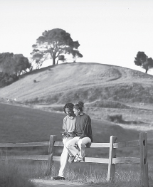
Hikers enjoy a quiet moment along China Camp State Park’s Shoreline Trail.
Once over a little rise, you begin to descend, only to climb again on a moderate grade to a T-junction with the Miwok Fire Trail.6 Descend left on this dirt road about 100 feet (closed ahead as of this writing), then turn right on the Oak Ridge Trail, right. This multiuse single track heads east along a ridgetop, crosses the McNears Fire Trail, and eventually provides terrific views of San Francisco, Angel Island, the Marin Headlands, and perhaps, on a clear day, Mt. Diablo.
Cross the McNears Fire Trail again and stay on the Oak Ridge Trail. Descend via easy switchbacks to a junction with the Peacock Gap Trail,7 which you join by going straight. At the next junction, turn left on the Shoreline Trail.8 Follow the trail as it ambles on a mostly level grade through a serene forest, with occasional views of San Pablo Bay. After about 1.5 miles on the Shoreline Trail, you reach a four-way junction with the closed Miwok Fire Trail. Continue straight on the Shoreline Trail, here a dirt road.
Soon the road divides.9 One branch goes straight, into the Miwok Meadows group day-use area, which has picnic tables and toilets. The other branch, your route, marked by a trail post for the Shoreline Trail, angles right into a large dirt parking area.
OPTIONS
Back Ranch Meadows Campground
Overnight camping is available in the Back Ranch Meadows Walk-In Campground. There are 30 walk-in family campsites, each with a picnic table, food locker, and fire ring. For camping reservations, call (800) 444-7275. To reserve the Miwok Meadows group day-use picnic area, call Marin District Special Events at (415) 898-4362, extension 23. It has barbeque grills, picnic tables, and chemical toilets (no running water) and can accommodate up to 200 people.
Great Views
After about 150 feet, you reach the end of the parking area, where you turn left and find the continuation of the Shoreline Trail, marked by a trail post. Soon level, the route crosses a wood bridge, swings right, and comes into the open. At a junction, right, with the Bullet Hill Trail, you continue straight.
Now the route gains elevation and bends left, running parallel to North San Pedro Road. Just south of Turtle Back Hill, the trail veers away from the road and you continue a level trek over mostly open ground, with woodland left and marshland right. Bear right at an upcoming fork, toward the campground parking area.10 Go right across the parking area to the park entrance road and follow it 100 yards to the day-use parking area.11
 MILESTONES
Trail 8
1 0.0 West from parking area to four-way junction, then right on Shoreline Trail
2 0.1 Left on Bay View Trail
3 0.4 Right on Powerline Fire Trail, then left on Bay View Trail
4 2.3 Straight on Back Ranch Fire Trail 100 yards, then right on Bay View Trail
5 3.4 At clearing, angle left on Ridge Fire Trail
6 3.7 Left on Miwok Fire Trail for 100 feet, then right on Oak Ridge Trail
7 4.9 Straight on Peacock Gap Trail
8 5.0 Left on Shoreline Trail
9 7.1 Miwok Meadows group day-use area; right through dirt parking area to Shoreline Trail
10 8.4 Right at fork to walk-in campground parking area; right to entrance road
11 8.4 Back at parking area