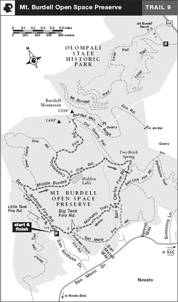
TRAIL 9 North Bay
Mt. Burdell Open Space Preserve
TRAIL USE
Hike, Run, Bike, Child Friendly, Dogs Allowed
LENGTH
5.6 miles, 3–4 hours
VERTICAL FEET
±1200'
DIFFICULTY
– 1 2 3 4 5 +
TRAIL TYPE
Loop
SURFACE TYPE
Dirt
FEATURES
Lake
Mountain
Wildflowers
Birds
Great Views
Photo Opportunity
FACILITIES
None
This loop explores the open grasslands, groves, and high ground of Burdell Mountain, a bulky ridge that rises to 1558 feet and dominates the northeast corner of Marin County.
Best Time
Spring wildflowers are a prime attraction; avoid the heat of summer.
Finding the Trail
From US Hwy. 101 in Novato, take the Atherton Ave./San Marin Dr. exit. Go west 2.2 miles on San Marin Dr., turn right onto San Andreas Dr., and go 0.6 mile to where the road makes a sweeping bend to the left. Park on the shoulder and observe the NO PARKING signs.
The trailhead is at the foot of the San Andreas Fire Rd., by the gate just northeast of the parking area. The trailhead stiles are a few steps right of the gate.
Trail Description
From the trailhead, 1 pass through the stiles and then curve left for about 100 feet to join the San Andreas Fire Road, which climbs on a gentle grade. Just beyond an information board, you pass the San Marin Fire Road, right. The San Andreas Fire Road, graded for a development that was never built, ascends to a wide, grassy saddle. Here the single track Dwarf Oak Trail enters on the left, and a faint road continues down the far side of the saddle. You angle right on the Middle Burdell Fire Road (part of the Bay Area Ridge Trail).2 The road wanders through an oak-dotted grassland as it gains elevation. Signs ask visitors to stay on the official trail to avoid habitat damage and aid its restoration.
 Lake
Lake
Where the Deer Camp Fire Road (part of the Bay Area Ridge Trail) goes left, you continue straight on the Middle Burdell Fire Road, climbing moderately over rocky ground. Turning a corner, the road levels and follows the edge of Hidden Lake, a large vernal pool. Several stiles allow access through a fence to the water’s edge. At a junction,3 the Middle Burdell Fire Road turns right, and the Cobblestone Fire Road, your route to the top of Burdell Mountain, heads left.
 Great Views
Turning left, you begin climbing on a moderate grade. The route gets steeper and rockier, but you are rewarded by terrific views west toward Big Rock Ridge and Bolinas Ridge, and southeast to San Pablo Bay and the peninsula that holds China Camp State Park. At a fork, the Deer Camp Fire Road comes in on the left, and your route, the Cobblestone Fire Road, veers right.
 Mountain
Now the road turns north, trying to find the easiest way up Burdell Mountain The climbing is moderate, with a few level areas to ease your efforts and some groves of bay and coast live oak for shade. Nearing the end of the climb, you come to junctions with the Old Quarry Trail, right, and the paved Burdell Mountain Ridge Fire Road.4 The preserve’s high point lies just ahead, across the road and at the end of a faint single-track trail that climbs north. The true summit of Burdell Mountain (1558') is just beyond the preserve boundary, unreachable on private land.
After exploring Burdell Mountain’s high ground, retrace your route down the Cobblestone Trail to Hidden Lake and the Middle Burdell Fire Road.5 Bear left, now on the Middle Burdell Fire Road, and head east over level ground. Dipping into and then out of a small wooded ravine, you soon pass junctions with the Old Quarry Trail, which climbs steeply to the Burdell Mountain Ridge Fire Road, and an unofficial trail heading up the grassy slope, both left. Several hundred feet ahead, the lower part of the Old Quarry Trail descends right.
Rock walls atop Burdell Mountain mark the preserve boundary. Although reminiscent of New England rock walls, these were built in the 19th century by Chinese laborers who worked in nearby quarries.
Continuing straight on the Middle Burdell Fire Road, you pass Two Brick Spring, left, and then amble through a bay grove to a T-junction.6 Here the Middle Burdell Fire Road angles left, but your route, the San Carlos Fire Road, turns right. After passing through a cattle gate, you enjoy a level, shady walk but soon resume a gentle descent in the open. You pass the Old Quarry Trail, right, and, about 350 feet ahead, the Salt Lick Fire Road, left. Continuing straight and downhill, the San Carlos Fire Road soon veers right, and then makes a sharp left-hand bend, putting you on a southeast course.
At a three-way junction,7 where the San Carlos Fire Road continues straight, you turn right onto the Michako Trail, a single track that is closed to bikes. Still descending, you pass through an opening in a fence, cross a seasonal creek on rocks, and then find level ground. Just past the creek, a faint trail heads left. Angle right to stay on the Michako Trail. After crossing a swale and a side trail, you meet the faint trail, which rejoins on the left.
The Michako Trail continues across open grassland, soon crossing—and then joining—the Big Tank Fire Road.8 About 150 feet ahead, you reach a four-way junction with the San Marin and Andreas Court fire roads, both left. Bear right on the San Marin Fire Road, which makes an easy descent to close the loop at the San Andreas Fire Road.9 Turn left here and retrace your route to the parking area.
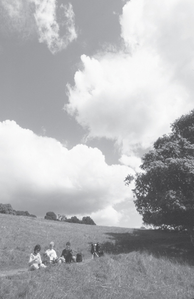
Lunch stop along the trail in Mt. Burdell Open Space Preserve.
 OPTIONS
Car-Shuttle Hike to Olompali State Historic Park
If you’d like to try a shuttle hike in the area, here’s a route that’s 7.8 miles one-way. From the junction of the Cobblestone and the Burdell Mountain Ridge fire roads,4 turn right and go 0.3 mile on the paved road, then climb left on a dirt road to a gate. Beyond the gate are two picnic tables with views of the Petaluma River and San Pablo Bay. At the picnic tables, turn left on the Mt. Burdell Trail, signed TO PARK ENTRANCE. This single track descends for about 5 miles to the old Burdell Ranch. Auto access to the state park is from southbound Hwy. 101, 2.4 miles south of San Antonio Rd.
 MILESTONES
Trail 9
1 0.0 Take San Andreas Fire Rd. north
2 0.8 Right on Middle Burdell Fire Rd.
3 1.5 Left on Cobblestone Fire Rd.
4 2.5 Burdell Mountain Ridge Fire Rd. and top of mountain, return to junction with Middle Burdell Fire Rd.
5 3.5 Left on Middle Burdell Fire Rd.
6 4.3 Right on San Carlos Fire Rd.
7 4.8 Right on Michako Trail
8 5.4 Straight on Big Tank Fire Rd.
9 5.6 Left on San Andreas Fire Rd., back at parking area