IN THIS CHAPTER
Summary: This chapter reviews how humans have organized the surface of the Earth into countries (also called states) and the conflicts that sometimes arise. The political geography of the Earth changes constantly as boundaries and borders change. The boundaries of countries change suddenly sometimes (for example, in war and armed conflict) or change gradually as states devolve (for example, in the case of the USSR). Alliances and the forces of globalization greatly impact the political geography of the Earth today.
Key Terms
alliances
antecedent boundary
centrifugal force
centripetal force
colonialism
confederation
consequent boundary
conservation agriculture
decolonization
devolution
domino theory
enclave
exclave
exclusive economic zone (EEZ)
federal state
forward capital
fragmented state
gerrymandering
growth pole
heartland-rimland theory
imperialism
irredentism
Mediterranean agriculture
nation
nationalism
nation-state
organic farming
relic boundary
separatism
sovereignty
subsequent boundary
superimposed boundary
supranationalism
terrorism
unitary state
Von Thünen’s agricultural land use model
The concepts of political geography involving states, territories, borders, and alliances are important in the study of AP Human Geography. These concepts help us understand the news headlines about territories and conflicts that we read on a daily basis. Spatial concepts of territory, state, and nationalism revolve around the political arrangement of space.
The Earth is divided into political units called states, or countries. (The term “state” refers to a country and not a political subdivision within the United States, such as Nevada or Maine.) Each country has a defined population and borders, in other words, boundaries that are defined. There are many examples of states in the world today. A nation is a unified group of people with a common culture. Examples of nations without a state or political territory of their own are the Kurds, the Navajo, and the Roma or “Gypsies” (see Fig. 9.1 below). Nation-state refers to a state in which over 90 percent of the population is comprised of a specific culture or group of people. Japan, Iceland, Armenia, Bangladesh, and Lesotho are examples of nation-states. Antarctica is the southernmost continent in the world and is neither a nation nor a state. Although several countries conduct scientific research on Antarctica, it has no permanent residents and does not belong to any country.
Countries have heartlands, or core areas, where economic development is usually the greatest. Many times the capital of the country is located within its core but sometimes it is found in a former core area. Capital cities are often relocated for various reasons. Brazil moved its capital from Rio de Janeiro inland to Brasilia to draw economic development into the country’s interior. Brasilia then became a growth pole, drawing people and jobs into the undeveloped interior. Pakistan moved its capital city from coastal Karachi to Islamabad near the contested territory of Kashmir to make a bold and aggressive statement to its rival (India) for control of the territory. Islamabad is a forward capital that makes a bold statement to the rest of the world.
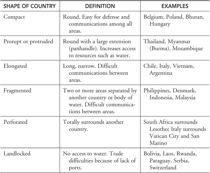
The shape of a country influences how easy it is to develop economically. A country’s shape either helps or hinders transportation and communication between different parts of the country and between the capital and the outlying areas of the country. The table here summarizes the categories used to describe the shapes of countries and gives some examples of each type.
Approximately 30 percent of the countries in Africa are landlocked as a result of the colonial era. Uganda, Central African Republic, Rwanda, Burundi, and Malawi are just a few of these countries without access to the ocean.
Frontiers and boundaries are important ways of delineating space. Frontiers are almost totally uninhabited areas, such as those found on the Arabian Peninsula and Antarctica. Unlike frontiers, which are areas not controlled by any state, boundaries are thin, invisible markers that are physical or cultural or a combination of both. Because they represent barriers to travel, physical boundaries such as mountains, deserts, and water often serve to separate states.
Cultural boundaries sometimes closely follow ethnicity and separate two or more cultural groups from each other. Most of the time, however, boundaries are geometric with lines drawn during colonial times with no respect for ethnic divisions. When the British partitioned India, religion dictated the boundary lines. Language was a major influence when the Versailles Peace Conference met to redraw the boundaries of Europe.
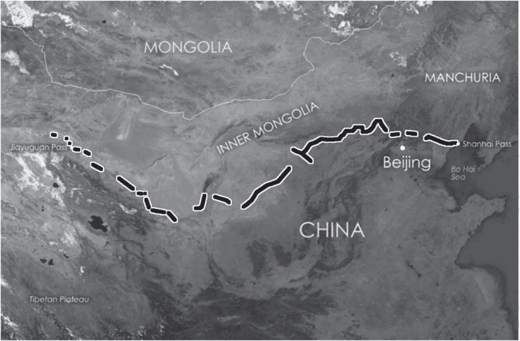
Antecedent boundaries are boundaries placed before the cultural landscape developed (in other words, very early in the area’s settlement history). Subsequent boundaries are drawn after the cultural landscape is in place, and consequent boundaries are a type of boundary that is drawn to accommodate existing language, religious, or other cultural boundaries. Superimposed boundaries are sometimes forced on existing boundaries as in the case of the division of Africa by European colonial powers during the nineteenth century. Relic boundaries are old boundaries that are no longer used between countries such as the now nonexistent boundary between North and South Vietnam. Another example of a relict boundary is the Great Wall of China (see Fig. 9.2), which was built during the third century B.C. (Ch’in dynasty) as a defensive border to repel invading Mongols from the north.
Disputes often arise over boundaries. Positional disputes occur when countries disagree about the interpretation of boundary documents. Sometimes boundaries are disputed because of superimposed boundaries that split an ethnic group into two different countries. Irredentism is the situation that arises when an ethnic group supports and seeks to reunite with its ethnic population in a neighboring country. Somalia has many border conflicts with Ethiopia over the rights of Somalis living in Ethiopia. Resource disputes often occur as two countries dispute ownership of a natural resource that lies on the border. Dispute over a rich oilfield on Iraq’s border with Kuwait was a major reason for Iraq’s invasion of Kuwait in 1990 to 1991 and the resulting Persian Gulf War.
All culture hearths developed some form of political organization of space so they could control and rule their people and lands. The idea of the modern political state developed in the early eighteenth century in Europe. Friedrich Ratzel, a German geographer, compared the political state to a living organism that had to expand and absorb nearby territories in order to survive. Germany used this theory to justify its invasion of neighboring states during World War II. Imperialism is the use of military threat, cultural domination, and economic sanctions to gain control of a country and its resources. Colonialism imposed a set of formal controls by the mother country over its colonies or outside territories. Today many countries with multiethnic populations still suffer conflict because of the superimposed boundaries placed by European colonial powers. Decolonization is the process by which former colonies gain their independence. The United States gained independence in the eighteenth century, Latin American colonies gained their independence during the nineteenth century, and most African colonies became independent during the twentieth century.
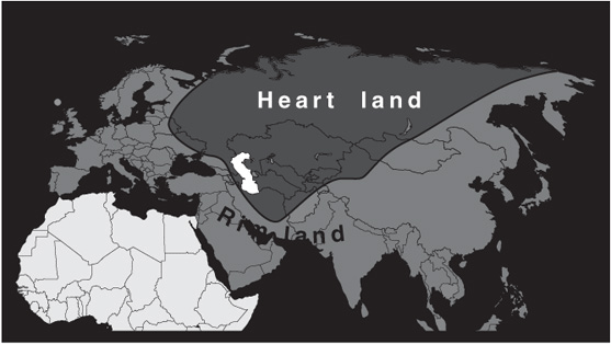
Halford Mackinder, an English geographer, developed the heartland-rimland theory to justify European colonization during the nineteenth century (see Fig. 9.3). He claimed the core of Eurasia was the heartland, and the surrounding territories comprised the rimland. The heartland was well positioned to dominate the world because of the immense size of its land mass. Since Russia formed a major part of the heartland, Mackinder influenced politicians of the day to try and limit Russia’s expansion by colonizing the territories near Russia.
The policy of containment was a direct offshoot of Mackinder’s heartland-rimland theory after World War II. The United States joined several European countries in various regional alliances such as the North Atlantic Treaty Organization (NATO) to prevent Soviet domination of Europe. In addition, the domino theory was a popular anti-communist theory between 1945 and 1990 that greatly influenced the foreign policy decisions of the United States during this time period. This theory stated that once a country became communist, the neighboring countries around it were likely to also become communist, like a column of dominoes falling over, one by one. The Vietnam War was a direct result of this theory as the United States tried to stop the spread of communism. During the Cold War era between the end of World War II and the dissolution of the Soviet Union in 1991, the balance of power between the world’s two superpowers, the United States and the Soviet Union, was a struggle between the noncommunist “free world” and the forces of communism.
In recent years, the use of terrorism as a tool of intimidation and coercion has increased. Terrorism is the use of violence in a controlled and intentional way to force attention onto issues. Terrorist attacks are aimed at a population and not a particular person (which is called assassination). The question of whether an act of violence is committed by a rebel or a terrorist is not easily answered at times. State-sponsored terrorism is different from terrorism and contains three escalating levels of participation: (1) the state provides sanctuary for those who have committed acts of terrorism; (2) the state provides weapons, military intelligence, and money to terrorists; and (3) the state plans acts of terrorism. A state guilty of any one or all of the above is to be viewed as a state that sponsors terrorism.
A number of factors today present interesting challenges to the world’s contemporary political system dominated by national governments. These challenges raise questions about the role of national governments in a global political system in which other types of organizations are increasingly acting on the international stage. These groups range from stateless terrorist groups to multinational organizations to transnational corporations and nongovernmental organizations. Some challenges to the traditional world order are explored here.
• Globalization of the economy and the new transnational corporations present an interesting challenge to the modern political order today. Transnational corporations make decisions for a level that transcends that of the state. Resource, staffing, production, and marketing decisions may involve several countries and economies and have direct implications for those economies.
• Supranational (an association of three or more states for mutual benefit) and multinational organizations require a surrender of at least partial authority of the individual state. Membership requires giving up individual rights for the common good and goals of the supranational group. The European Union (EU) and North American Free Trade Association (NAFTA) are two supranational trade blocs that supersede individual countries’ decisions regarding trade.
• Nongovernmental organizations (NGOs) reflect special interest groups such as women’s and children’s rights, AIDS prevention, etc. They often use the media to pressure the central governments of countries to take action or limit action. Thus national governments often must respond to international groups and pressures in making domestic policies.
• Immigrants find it much easier to retain close ties with their homelands through modern communications technology. This often leads to a lessened response to assimilation into the new country and continued loyalties to the old one. The result is a challenge to traditional ideas of national citizenship and unity.
Sovereignty refers to the internationally recognized exercise of a country’s power over its people and territory. A federal state is a type of government that gives local political units (such as states or provinces) within a country a measure of power. The United States, Canada, Germany, Australia, Switzerland, and India are examples of federal states. Recently, there has been a trend toward federal government in the world. Unitary states allocate most of the power to a strong central government. France and Sweden are examples of unitary states. Sometimes the devolution, or breakup, of a multinational state can create a host of problems. Over 200 different ethnic groups resided in the Soviet Union. After the breakup of its strong centralized authoritarian government, most of the former Soviet republics joined a confederation of states to retain some cohesion.
Some countries are geographically fragmented with a portion of their territory completely surrounded by another country’s territory. An outlier (piece of a country that is separate from the main territory) that is enclosed within the borders of another country is called an exclave. Nagorno-Karabakh is an Armenian exclave located totally within, and under the jurisdiction of, Azerbaijan. Armenia (and Nagorno-Karabakh) are Christian, but Azerbaijan is a Muslim country so tensions are always present. An enclave is a piece of territory that is completely surrounded by another territory of which it is not a part. Nagorno-Karabakh would be the enclave to those living within the territory.
Countries are constantly subjected to centripetal forces that unite and centrifugal forces that divide. When unifying forces (centripetal) dominate, the country will stand strong in the face of international challenges and conflicts, as well as conflicts within its borders. When forces within threaten to divide the country (centrifugal), a breakdown of central authority may occur. Forces such as a strong, charismatic leader, national anthems, national holidays, and national institutions such as schools are all strong centripetal forces in a country. Nationalism, or the strong love of and loyalty to one’s country, is also a potent unifying force. Nationalism also involves the concept that a nation has the right to govern itself without the interference of others.
Centrifugal forces such as religious differences and poor transportation and communication systems can be strong divisive forces within a country. Nationalism can also serve to divide a country when an ethnic or a cultural minority seeks political autonomy or the right to self-governance. This separatism sometimes leads to devolution (a breakdown or weakening of central authority) as the central government ends up giving the minority separatist group some of its demands to keep the peace. Separatist groups include the Moros of the Philippines, the Basques of Spain, the Bretons of France, and the Sikhs in India. The collapse of the former Soviet Union has led to several challenges to ethnic individuality and rights. Most separatist groups operate on the periphery and suffer from unequal treatment both politically and economically. This neglect coupled with poor linkages to the central government leads to a feeling of marginalization and resentment that spawns further unrest and strife.
Alliances are associations among countries for the purpose of mutual defense or trade purposes. Some alliances are on a regional scale, such as the Association of Southeast Asian Nations (ASEAN) and some are on an international scale (the United Nations). Some are for political, military, or defense purposes and other alliances are economic in purpose, such as the European Union (EU), North American Free Trade Agreement (NAFTA), Caribbean Community and Common Market (CARICOM), etc. Countries realize they need to cooperate with other countries to keep their borders secure and to guarantee economic and trade advantages so they join with other countries to provide these benefits. International alliances water down an individual country’s authority while, at the same time, giving that country the assurance that members of the alliance will back them up. The United Nations (UN) attempts to include all countries of the world, but it does exclude some countries such as Taiwan (with the opinion that Taiwan is a province of the People’s Republic of China). The UN’s increasing use of the policy of intervention to protect human rights without regard to matters of state sovereignty or jurisdiction has created a supranational organization with the right to override a country’s absolute sovereign jurisdiction over its inhabitants. While the UN cannot force countries to agree on a disputed issue, it can exert the force of a majority consensus in the eyes of the world, which can be a powerful influence to wield!
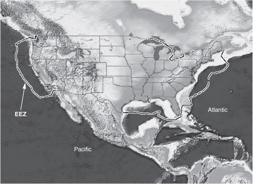
Starting in 1982, the oceans of the Earth have been regulated by a treaty known as the United Nations Convention on the Law of the Sea (although the United States has never officially ratified it). This convention sets up rules regarding water boundaries and rights of usage for the Earth’s oceans.
Under this treaty, a coastal state has:
1. Exclusive fishing rights and sovereignty over a territorial sea of up to 12 nautical miles from its coast.
2. Limited jurisdiction over a territorial sea up to 24 nautical miles from its coast (the right to enforce laws of immigration, sanitation, hot pursuit).
3. An exclusive economic zone (EEZ) of up to 200 nautical miles off its coast for natural resource exploration and exploitation (see Fig. 9.4 below).
The high seas beyond the EEZs of coastal states are open for free use by all political states. Any country can fish, fly over, perform scientific research in, and pass through these high seas at will. Of course, competing claims to EEZs overlap in many areas of the Pacific Ocean, the South China Sea, etc., so countries must negotiate terms of use or face future conflicts and tensions.
Territorial organization refers to government representation determined by spatial area. In a representative form of government like that of the United States, residents of a spatial area (congressional district, for example) elect representatives to stand for their views and interests in the larger governing body. Periodically, the boundaries of voting districts are redrawn to better represent the voting interests of the residents and to ensure fair and equal representation. The state legislatures take care of this in the United States, but in Europe, independent commissions are charged with redrawing boundaries. Gerrymandering is the process of redrawing territorial district boundaries to benefit a certain political party. Political opposition can be spread over several districts and thus diluted (wasted vote) or it can be concentrated into a few districts (excess vote). The drawing of odd-shaped boundaries is an attempt to corner like-minded voters who are spread out spatially into one district.
The countries of the world (states) are political units with constantly changing boundaries, associations, alliances, and concerns. They are subject to forces that unify and divide and are greatly influenced by conflicts both within and outside their borders.
1. Which one of the following is the best example of a nation-state?
(A) Germany
(B) Italy
(C) Vietnam
(D) Japan
(E) England
2. A part of a country that is separated from the main country by the territory of another country is
(A) an island.
(B) ghetto.
(C) an enclave.
(D) a peninsula.
(E) a colony.
3. The celebration of a national holiday is an example of
(A) centrifugal force.
(B) centripetal force.
(C) terrorism.
(D) insurgency.
(E) revolution.
4. Mackinder’s heartland-rimland theory predicted
(A) the Muslim takeover of the world.
(B) the rise of British colonialism.
(C) that the Japanese would conquer the Pacific Rim.
(D) that a nation from Eurasia would conquer the world.
(E) the rise of nationalism in Europe.
5. What would probably be the easiest shape of a state for national defense?
(A) Compact
(B) Elongated
(C) Prorupt
(D) Fragmented
(E) Perforated
1. D—Japan is a nation-state or a country with a large, homogenous population living within its borders. The other answer choices are all states with more diverse populations comprised of several nationalities.
2. C—An enclave is a piece of territory that is completely surrounded by another territory of which it is not a part. An island (A) is a piece of land surrounded by water. A ghetto (B) is an ethnic enclave where the residents live segregated by race, religion, or ethnicity in a voluntary—or sometimes forced—manner. A peninsula (D) is a piece of land surrounded on three sides by water. A colony (E) is a territory under the political control of a state.
3. B—National holidays, songs, symbols, flags, and other similar icons are unifying (centripetal) forces in a country. A centrifugal force (A) is one that divides a country. Terrorism (C) is the use of violence in a controlled and intentional way to force attention onto issues. An insurgency (D) is an organized and armed uprising against authority within a country. A revolution (E) is a fundamental change in power or organizational structures that takes place in a very short period of time.
4. D—Mackinder’s theory focused on the effects of Eurasia’s potential domination of the world from its base of being the largest and most-populated landmass in the world. Mackinder did not address religious domination of the world (A). Britain (B) was already a huge naval empire that ruled the seas, so his theory was in direct conflict with the existing world order. Mackinder’s theory had nothing to do with predicting the dominance of Japan (C). The theory was concerned with the future power relationship in the world, not with the rise of nationalism in Europe (E).
5. A—The generally round shape of a compact state makes communication and transportation among all areas easier, thus also making it easier to defend. The other answer choices list shapes of states that would be more difficult to defend because communications between distant parts of the countries would be more difficult, and the borders would be much longer relative to the size of the country.