IN THIS CHAPTER
Summary: Cities perform important functions in their societies. Most cities throughout the world are growing at a rapid pace that exceeds population growth in their regions. Seventy-five percent of Americans now live in cities, and the proportion of Europeans, Russians, Australians, and Japanese who live in cities is almost as high. Even countries and regions with low urbanization rates have cities of sizeable populations. World cities, megacities, and supercities all play important roles in their respective regions. This chapter reviews the main functions of cities and the relationships within the city itself and between the city and its surrounding hinterland.
Key Terms
basic sector
bid-rent curve
central business district (CBD)
central place theory
concentric zone model
congregation
edge city
gateway city
gentrification
ghettoization
gravity model
Green Revolution
hinterlands
megacity
megalopolis
multiple nuclei model
multiplier effect
New Urbanism
non-basic sector
primate city
public housing
rank-size rule
rural-to-urban migration
sector model
segregation
site
suburbanization
supercity
uneven development
urbanization
urban renewal
urban sprawl
world city
Almost half of the world’s population lives in cities, and the urban population is growing at a much higher rate than the rural population. With this massive migration into cities and urban areas, it is important to learn more about urban dynamics—it is the wave of the future.
The city is the center of every advanced society and serves as the economic, political, and social hub of a geographic region or area. The larger the city becomes, the more activities it develops as it assumes more responsibilities and functions for the populations within its hinterland or surrounding trade area. All cities provide the following functions: retail and wholesale operations; manufacturing, political, transportation, communication, education, religious, medical, legal, and financial services; defense and safety, and entertainment.
A city is interconnected to other cities within the region and often possesses a specialized function, or purpose, within that region. All cities have a site or local setting and a situation or regional setting, which evolve and change over time. For example, Pittsburgh’s site is at the confluence of the Monongahela and Allegheny Rivers. Long ago its situation was a strategic defensive position as a fort during the early colonial days. Then Pittsburgh’s situation changed as it boomed as a major steel-producing city because of the transportation advantages of being situated on three rivers. The abundant raw materials from the region were transported down the rivers to the steel mills in Pittsburgh, and finished steel was shipped down the Ohio River to destinations all over the world.
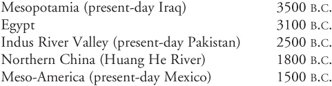
The first cities or urban settlements developed in the following approximate order in five regions of the world:
A combination of factors is responsible for the development of cities: agricultural surpluses, hydrological factors, increasing population densities, defense needs, religious reasons, and trade requirements.
Urbanization spread from these areas of origin in an uneven fashion, often as the result of long-distance trade. An example of this is the ancient Silk Road—a trade route that stretched across Central Asia from China to Europe. The Greek city-states along the Mediterranean coastline evolved from their Mesopotamian hearth and served defense, trade, religious, and administrative functions. The Roman Empire displaced Greek dominance around 338 B.C. and the rapidly expanding Roman Empire with its well-connected transportation networks established cities across southern Europe by A.D. 200; the Western European city is based on their set-up. During the Dark Ages in Europe, the urban centers in Arab regions, such as Baghdad and Mecca, thrived and prospered.
The increase in trade during the following medieval and Renaissance periods (fourteen to eighteenth centuries) spurred urban revival in Europe. Beginning in the sixteenth century, European colonization of Latin America by Spain and Portugal created colonial cities with a focus on administration and military defense. Gateway cities were established worldwide as control centers for the colonial powers. The Industrial Revolution in England ensured that cities took on the function of manufacturing and production centers. From England, industrialization and urbanization spread into other parts of Europe.
Urbanization is the rapid growth of—and migration to—large cities. Today urbanization is taking place at a rapid rate in most LDCs. Rural-to-urban migration is the movement of people from the countryside to the city usually in search of economic opportunities (jobs) and a better life (both “pull” factors of migration). This increase in urban population causes rapid physical expansion of cities and greater urbanization of the society. Because of this rapid urbanization, cities in LDCs face the following problems: increased levels of pollution and traffic congestion, shortages of clean drinking water, insufficient sanitation services, lack of sufficient electrical power, lack of enough job opportunities, strained education and healthcare facilities, housing shortages, and increased problems with drugs, gangs, and violence. A supercity is a very large city and a megalopolis is a group of super-cities that have merged together into one large urban area.
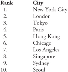
A world city (also called a global city) is a city that serves as an important linkage or connection point in the global economic system. These cities serve as banking and finance world leaders and headquarters for multinational corporations (MNCs). They are also world communication and transportation hubs and have the most international political influence. The top-10 world cities (2010) in order of rank, according to urban sociologist Saskia Sassen are:
A megacity is a metropolitan area with a total population of over 10 million people according to the United Nations. A growing number of megacities are found in LDCs, and they share the common characteristics of high population density, poverty, and limited resources. Problems that are rampant in megacities are high infectious disease rates, vulnerability to terrorism, natural hazards, ecological disasters, war conditions, and food scarcity. Competition for scarce resources and jobs often fosters social unrest in these cities. Waste disposal and air pollution are problems in megacities in both DCs and LDCs. Megacities are indicators of social and economic change in their country and region. For example, Karachi generates 20 percent of Pakistan’s GDP and provides 50 percent of the government’s revenue. Often, these cities are the site of cultural and educational institutions that promote social development, too. Finally, megacities are large, new markets for both DCs and LDCs.
With rapid urbanization occurring in North America since the end of World War II (1945), suburbanization, or the movement of people from urban core areas to surrounding the outer edges of the cities became a dynamic force in American society. This rapid change in the distribution of the population was aided by the widespread availability of the automobile as families were no longer totally dependent on fixed-route public transit systems. The 40-hour work-week gave Americans the opportunity to live farther from their workplaces since they now had time to commute. The housing boom that followed World War II was fueled by the increased need for family housing as families grew and changes in the home loan structures made home mortgages affordable for middle-class families.
During the 1970s, suburbanization reached a frenzied pace as developers converted 200 acres of rural land into urban use every hour. As population shifted to the outskirts of cities, so did the purchasing power; strip malls and shopping centers sprang up everywhere to service the suburbs. Industry was also attracted to the suburbs because of the large parking capacity and room for plant growth. Service industries followed to provide services for the workers and suburban families. In the 1990s, urban sprawl was deemphasized, development became more intensive, and suburbs became more self-sufficient—complete cities in themselves. Industrial parks, apartment and condominium complexes, office parks, and gated communities became the “new suburbia.” These new urban complexes are called edge cities, and they contain large nodes of office buildings and commercial operations with more workers than residents.
Geographer Mark Jefferson theorized the primate city is at least twice as large as the next largest city in the country and more than twice as significant. Capital cities are often, but not always, primate cities. However, not every country has a primate city. Examples of primate cities are Paris, London, and Mexico City. Paris, with 2.2 million in the city itself and a metropolitan area of almost 12 million, is definitely the focus of France, while the next-largest city of Marseilles has a population of only 800,000. London is the United Kingdom’s primate city (6.9 million with a metropolitan area of over 12 million), while the second largest city, Birmingham, is home to only a million people. Mexico City, with 9.8 million in the city and 16.6 million in the metropolitan area, is a primate city while the next-largest city, Guadalajara, has only 1.7 million. Many African cities show primacy because they were once colonial capitals and centers of administration and power.
In most countries, there are many more small cities than large ones. The rank-size rule proposed by Zipf states that if all cities in a country are placed in order from the largest to the smallest, the rate of decrease in size of each city’s population is large at first but quickly slows. Zipf postulated that the second-largest city would have about half the population of the largest city, the third-largest city would have about a third of the population of the largest city, the fourth-largest city would have about one-quarter the population of the largest city, etc. The United States and Russia come closest to complying with Zipf’s rank-size rule, but no country completely satisfies it.
Every city has an influence on its surrounding hinterlands (urban influence zone). Geographer Walter Christaller developed a central place theory, which states that cities exist for economic reasons and that people gather together in cities to share goods and ideas. Therefore, the central place exists chiefly to provide goods and services to its surrounding population and functions as a distribution center. The assumptions of this theory are that the countryside would be flat, presenting no barriers to the movement of people across it. In addition, Christaller stated that humans will always purchase goods from the closest place that offers the good, and when a high demand for a certain good exists, the good will be offered in close proximity to the population. When demand drops, so does the availability of the good.
The threshold is the minimum number of people needed for a central place business or activity to thrive and stay prosperous. Christaller concluded that towns and cities in his model were interdependent. Consumers would be willing to travel further for luxury goods but not for simple basics like milk and butter.
The gravity model is a law of spatial interaction based on Newton’s law of gravity. It states that larger places attract people, ideas, and goods more strongly than smaller places. It also asserts that places closer together have a greater attraction. The relative strength of a bond between two places is determined by multiplying the population of city A by the population of city B and then dividing the product by the distance between the two cities squared.
Several models of urban land use have been developed, but the central business district (CBD) is at the center of every urban land use model. The CBD is found at the center of every older central city and is the area of skyscrapers, business headquarters, large banks, and crowded streets. Fanning out from this intensive land use area is a fringe of wholesale and retail businesses, warehouses, bus and light rail terminals, and light industry. The residential area extends outward beyond this ring of activity. Several models attempt to depict urban land use spatially.
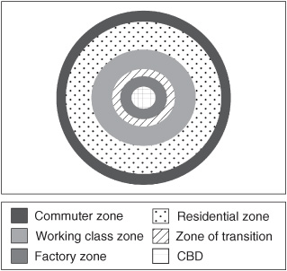
Sociologist Ernest Burgess developed the concentric zone model in the 1920s based on his studies of Chicago. The model is dynamic—as the city grows and expands, the inner rings invade the outer ones. This invasion and succession process occurs continually as the city grows and expands outward. Burgess’s work is based on the bid rent curve, which states that the concentric circles are based on the amount that people will pay for the land. The amount they will pay depends on the profits that are available from maintaining a business on that land. The CBD will have the highest number of customers so it is profitable for retail activities. Manufacturing will pay less for the land as they are only interested in the accessibility for workers and “goods in” and “goods out.” Residential land use will take the land beyond these circles (see Fig. 12.1).
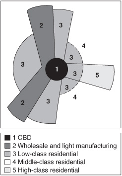
In 1939, economist Homer Hoyt developed the sector model in which urban growth creates a pie-shaped urban structure due, in large measure, to the improvement of transportation. For example, the electric trolley extended low-income areas from the CBD to the outer edge of the city (see Fig. 12.2).
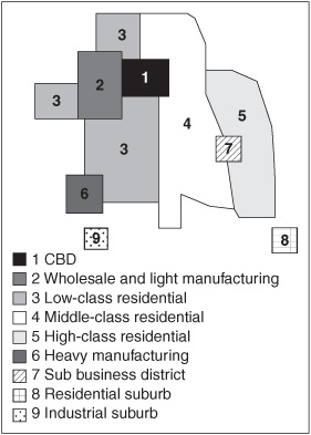
The multiple nuclei model was developed by Chauncey Harris and Edward Ullman in 1945 (see Fig. 12.3). They claimed the CBD was no longer the only nucleus of the urban area, but that other separate nuclei become specialized and differentiated. They concluded that the following attributes determine where these multiple nuclei, or nodes, are located:
• Differential accessibility. Wholesale activities require ports and railroad terminals while the retail sector requires maximum accessibility and parking.
• Land use compatibility. Centripetal forces operate based on economies of agglomeration. Some activities interact powerfully with one another such as banking and financial institutions.
• Land use incompatibility. Some activities repel each other causing centrifugal forces to operate. Heavy industry repels high-end residential areas, for example.
• Location suitability. Some activities must locate at a suboptimal location because of cost factors.
To keep these three models straight, think of the following analogies if they help you remember:
• Concentric zone model: the growth rings of a tree
• Sector model: a pie cut in wedges
• Multiple nuclei model: a chocolate chip cookie with each nucleus a chocolate chip in the urban cookie
Cities are experiencing changes in demographic and social structures. Social area analysis uses parts of each of the three models above to explain why people live where they live in urban areas. The models are too basic and oversimplified to adequately explain residential preferences, and they relate only to US cities between the two World Wars; however, when used in combination, certain valuable facts can be surmised about housing in US cities.
The concept of the city is universal, but the land-use structure of the city differs from one region to the next based in part on cultural and regional differences. A quick review of other regions of the world follows.
Canadian cities are more compact than US cities; they typically contain more multiple-family apartment buildings and higher population densities. Public mass transportation is preferred, and expressways are less expansive and less widely used in Canadian cities than in the United States. A higher foreign-born population and much less suburbanization has helped homogenize urban populations in Canada, too, allowing greater social stability and higher average incomes than in comparable US cities.
West European cities share a common history with traces of Roman and Renaissance architecture, street patterns, and spatial layout often evident. They are more compact than US cities and lack urban sprawl and suburbanization. As in Canadian cities, West European cities have higher residential densities and a heavy reliance on public transportation. Mixed retail, business, and residential zones keep work and home in close proximity. European cities often have energetic downtown areas with social life blending with worksites. The old, historic core is gentrified and home to middle- and upper-class families, while less affluent residential zones exist on the periphery along with recently established industry. Immigrants live on the fringes of the city, unlike the poor conditions of American inner-city slums.
Land use in East European cities remains heavily influenced by the centrally administered planners of the communist era, with a large central square containing government and cultural buildings common to most cities. The communist government—not the market—controlled land use; however, like West European cities, East European cities are compact, have high residential densities, and heavily rely on public mass transportation. Residential areas contain their own retail and service facilities and a large park or recreation area is always located near the central square.
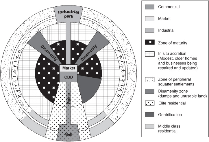
Latin American cities focus heavily on the central section of the city with transportation systems leading to center city. City life is the cultural norm and the well-to-do and middle-class populations live, work, shop, and attend cultural events there. The periphery is mostly reserved for the poor and less fortunate. Figure 12.4 depicts the important features of a central spine or avenue extending central city residential areas and retail shops outward to the periphery and a ring highway that encircles the city and separates high-income from low-income residential areas. Squatter encampments and slums (favelas, barrios) are generally located on the outermost rings of the city and not in the crumbling inner city of the US urban model (Fig. 12.4 below).
Sub-Saharan Africa is the most rapidly urbanizing region of the world with urban populations growing far more rapidly than urban economies. This has created a gross inability to provide even the most basic amenities, such as clean drinking water and rudimentary sanitation services to most residents. Disease, high rates of infant mortality, and low life expectancies are serious problems.
Cities in North Africa and the Middle East region suffer structural deterioration, massive overcrowding, and uncontrolled urban sprawl. Sanitation and other basic amenities are not provided for many residents and high birth rates, high immigrant rates, and high unemployment provide major challenges to urban governments.
Asian cities, on the other hand, are riding the wave of economic prosperity with city growth unparalleled in Asian history. The number of Asian megacities (cities with over 10 million inhabitants) is predicted to reach nearly 20 by 2020. Mega-urban-regions (huge, sprawling urban concentrations) link huge cities together in vast concentrations of humanity.
Cities in the developing world differ greatly between regions. However, there are some important commonalities. Virtually all cities in the developing world:
• Have a large, vigorous informal economic sector
• Receive large numbers of rural migrants
• Produce a major portion of their country’s gross domestic income (GDI)
• Are surrounded by huge high-density areas of squatter settlements with few if any amenities
Other important things to remember about cities in the developing world include:
• Colonial impact heavily influences many cities in former colonies.
• Centrally planned land-use patterns influenced many Asian cities.
• Forward capitals are new cities recently built to serve a growing and changing country.
• Cities serving as religious centers are strongly influenced by religion.
• Traditional cities are crowded with a single major business district.
• Modernized cities take on Western characteristics (CBD, public transportation).
• The chief purpose of the city governs land-use patterns (ports, industrial, mining center, markets).
Cities employ workers in both the basic and non-basic sectors of the economy. Workers who produce goods and services for individuals outside the urban area work are in the basic sector and produce an income flow of new money into the city. The non-basic sector workers produce goods and services for people employed within the urban area—to make it safer, healthier, and a better place to live and work. These jobs do not generate an income flow into the city. Usually, more basic jobs create a healthier, more prosperous urban economic base because fresh money is generated.
The multiplier effect can provide insight as to how many non-basic jobs are created by one basic job. Usually at least two non-basic jobs are created for every new basic job. Non-basic jobs also create more non-basic jobs because service workers also require services themselves. Some cities are huge service centers with new service activities serving older service industries. An example of this would be where computer industries serve the financial and banking industries. The size of the multiplier effect for any given year can be expressed as:

When the demand for goods and services produced by a city falls, the need for workers also decreases, although workers often hesitate to leave because of ties to families and the local community. In the United States, cities in both the South and West have grown in recent decades while many of those in the Northeast and Midwest are experiencing declining populations.
Many US cities are full of marked contrasts—rich and poor, black and white, Latino and Anglo, immigrant and nonimmigrant. Uneven development plagues US cities as some areas receive lots of investment dollars and other areas receive only token amounts. Stunning contrasts between wealthy mansions and low-income neighborhoods abound in the older industrial cities of the Northeast and Midwest. Recently, however, some cities have enjoyed an economic comeback. The investment dollars filter very slowly into low-income neighborhoods, while finding their way into the more affluent areas. The inequities of public investment in urban centers represent uneven development on a small scale and mimic what we have seen in the core-periphery global scale.
As central city populations decrease, the US suburban populations keep rising. In 1950, 40 percent of Americans lived in central cities and 40 percent lived in rural areas and small towns. In 2000, over half of all Americans resided in the suburbs with 30 percent living in central city neighborhoods and the remainder in small towns and rural areas. The inner city neighborhoods are deteriorating because the majority of the housing was built before 1940 and has fallen into disrepair. As middle-class families move out of deteriorating neighborhoods into areas further from the central city, lower-income residents move in and the tax base continues to erode. Services for these low-income residents are a heavy burden to the city government, which subsidizes low-income housing and services. The cutbacks in city services and amenities in these neighborhoods encourage middle-class families to continue out-migration.
Segregation is the physical separation of two groups of a population; in the United States, it is usually based on race. The levels of black-white segregation have decreased somewhat in the last decade in the United States; however, racial segregation continues to be a prominent feature of the country’s urban areas. Income also segregates neighborhoods spatially with different sides of a city settled by different income classes. In the United States, families with higher incomes seek residential neighborhoods with natural beauty and good schools while cheaper, unattractive land near industrial areas and railroad yards provides inexpensive housing for lower-income residents.
Housing density decreases as you travel outward from the city center. The number of houses or dwellings per unit of land decreases as distance from the center city increases. The number of residents living in city centers has decreased over the years as population declines and old tenement housing is abandoned and condemned. Housing density on the periphery of the city, however, has increased as new apartment complexes and housing projects diffuse outward. After World War II, the system of housing development that became commonplace was based on the distinct separation of uses, rather than the creation of neighborhoods. For example, retail shopping was strictly separated into shopping centers and strip malls. Residential housing was the only type of use permitted in suburban housing developments. This separate-use system has become known as urban sprawl or conventional suburban development (CSD). The majority of the US population now lives in suburban communities built during the last 60 years. This sprawl creates more dependency on the automobile and less dependency on public transportation systems. Streetcar suburbs built in the late 1800s have a higher housing density and are located near a former streetcar stop or station. Commuters traveled by railroad and streetcar between home and work. After the automobile became a viable means of transportation for many, large-scale development of the suburbs became feasible and commuters could live farther from the city where they worked.
Landlords in cities are required by city code to keep houses and apartment buildings in good condition. Sometimes, landlords cannot afford or choose not to maintain properties and abandon them instead. When rent is insufficient to maintain the apartment, the building will soon deteriorate past the condition fit for human occupancy and even the poorest tenants will vacate the premises to move to less run-down structures. Urban renewal refers to the process of identifying properties in inner-city neighborhoods that are then acquired, cleared of residents and structures, and then handed over to private investors or public agencies for construction of parks, schools, or new housing. Critics of urban renewal claim it has reduced the supply of low-cost housing and destroyed the older neighborhoods’ sense of community.
Public housing is government-constructed and regulated low-income housing. The US government no longer funds the construction of new public housing since the old structures are not maintained and have deteriorated into run-down, high-crime neighborhoods. In the United Kingdom, over one-fifth of all housing is government-owned with private landlords controlling a very small portion of the housing. In Western Europe, governments subsidize construction of much of the privately built low-income housing but do not own the housing. Church groups and nonprofit organizations usually build the low-cost housing.
Older neighborhoods near the city center are sometimes renovated by middle-class and higher-income families in a process called gentrification. These areas were often enclaves of the wealthy, and the houses are usually architecturally interesting, large, and well built, while also being fairly inexpensive. Critics claim government subsidies (tax breaks and low-interest loans) for gentrification have the effect of stealing low-income housing and funding and using it to pay for middle-class renovation.
Different ethnic groups often group in specific parts of the city in a process called congregation. Minority groups based on ethnicity, religion, culture, or lifestyle live closer together to support each other and minimize conflict with nonminority groups. When discrimination is the reason for congregation, segregation is the result. Ghettoization is the concentration of a certain group of residents to a certain area against their will through either legal means or practices of social discrimination.
The large and rapidly-growing urban areas of the less-developed countries all share a common characteristic—outer rings of slums and shantytowns. A shantytown (called favela in Brazil) is a spontaneous settlement that is often built illegally on vacant land on the edge of a city or along roadsides. The residents live without the most basic amenities such as clean drinking water and sanitation services.
New Urbanism is an urban design movement that started in the United States in the early 1980s and is very influential in urban planning today. The main emphasis of this urban design is a return to earlier neighborhoods and a sense of community. Sidewalks and traditional neighborhood designs are thought to reduce traffic congestion, increase the amount of affordable housing, and stop urban sprawl. Neighborhoods are designed to be pedestrian-friendly with assorted shops, retailing, recreational areas, and other structures within easy access of residential areas. The overall emphasis is to reduce dependency on the automobile and promote safer, more environmentally friendly neighborhoods.
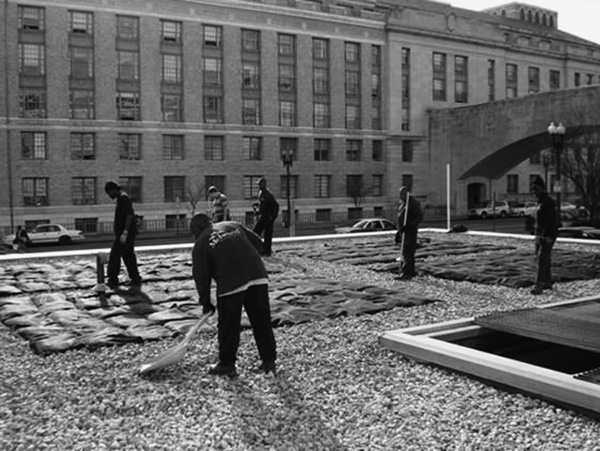
Green building (also known as green construction or sustainable building) is the practice of building structure using materials and processes that are environmentally safe and resource-efficient throughout a building’s lifecycle: design, construction, maintenance, renovation, and demolition. Green building tries to minimize the impacts of new buildings on the environment and human health while using energy-efficient, non-polluting, resource-conserving methods and materials. Use of renewable resources through passive and active solar systems, photovoltaic techniques, and use of vegetation through green roofs, rain gardens, and for reduction of rainwater run-off, are just a few techniques widely used in green building. The use of packed gravel and permeable concrete instead of conventional concrete or asphalt to assist in the replenishment of ground water is another green building technique that is popular (see Fig. 12.5).
Urbanization is a global occurrence with the majority of the world’s population now living in cities. Each city has specific functions to perform for its residents and surrounding hinterlands. City land use and social structures vary among regions of the world and even within a region sometimes. Several models help explain land-use patterns in the United States. Cities in LDCs are growing in size so rapidly they are unable to provide housing, jobs, or social services for most of the new residents.
1. An edge city could have any of the following attributes EXCEPT
(A) more jobs than bedrooms.
(B) being commonly perceived as a single place.
(C) 500,000 square feet of retail area.
(D) 500,000 square feet of office area.
(E) being urban for 30 years or more.
2. A crucial part of Christaller’s central place theory is the fact that goods and services vary in range and
(A) access.
(B) quantity.
(C) spatial distribution.
(D) threshold.
(E) quality.
3. If you commuted to work by automobile every day in the city, in which zone of Burgess’s concentric zone model would you be most likely to live?
(A) 1
(B) 2
(C) 3
(D) 4
(E) 5
4. The movement of middle-class residents into rundown urban center city neighborhoods is called
(A) urban renewal.
(B) urban sprawl.
(C) urban revitalization.
(D) gentrification.
(E) multiplier effect.
5. Which one of the following characteristics does NOT apply to cities of the developing world?
(A) Rapid population growth
(B) An inability to provide basic services for population
(C) A colonial heritage
(D) A small informal economic sector
(E) A land-use pattern strongly influenced by function of the city
1. E—Edge cities are a new phenomenon that developed in the 1990s when rapidly expanding suburban areas took on the functions and characteristics of a city themselves as industry and retail areas followed the population. Choices A through D are all true characteristics of edge cities.
2. D—The threshold is the size of the population needed to make it possible to supply the good or service and the range is the average furthest distance the population would be willing to travel to obtain the good or service. The other answer choices are not applicable as central tenets to Christaller’s central place theory.
3. E—You would live in the outermost concentric ring as a commuter—zone 5. Zone 1 (A) is the CBD. Zone 2 (B) is a transition zone that includes inner-city neighborhoods and ethnic ghettos on the edge of the CBD. Zone 3 (C) is a zone of independent working-class housing. These low-density residential suburbs were just evolving at the time Burgess developed this model. Zone 4 (D) is a zone of better residential housing composed of high-rent apartment complexes and single-family homes.
4. D—Gentrification is the process of middle-class and wealthy individuals buying and restoring once-stately and magnificent homes in older rundown areas near the CBD. Urban renewal (A) is the process of identifying properties in inner-city neighborhoods that are then purchased, cleared of residents and structures, and then handed over to private investors or public agencies for construction of parks, schools, or new housing. Urban sprawl (B) is a pattern of urban expansion that is based on separate use of land for residential neighborhoods, retail shopping centers and strip malls, etc. Urban revitalization (C) is another way of saying urban renewal that is preferred by some people since urban renewal has taken on negative connotations. The multiplier effect (E) refers to the number of non-basic jobs created by each basic job in the city.
5. D—All cities of the developing world contain a large and vigorous informal economic sector employing many individuals in jobs such as street vendors, errand runners, trinket peddlers, etc., who are outside the mainstream economy of wage jobs. Thus statement D is the one that does not apply. Rapid population growth (A), a basic inability to provide even the most basic services such as clean drinking water and housing for residents (B), and a strong heritage from colonial days (C) are typical of cities in the developing world. In all cities, the land-use pattern is strongly influenced by the function of the city (port, trading center, etc.).