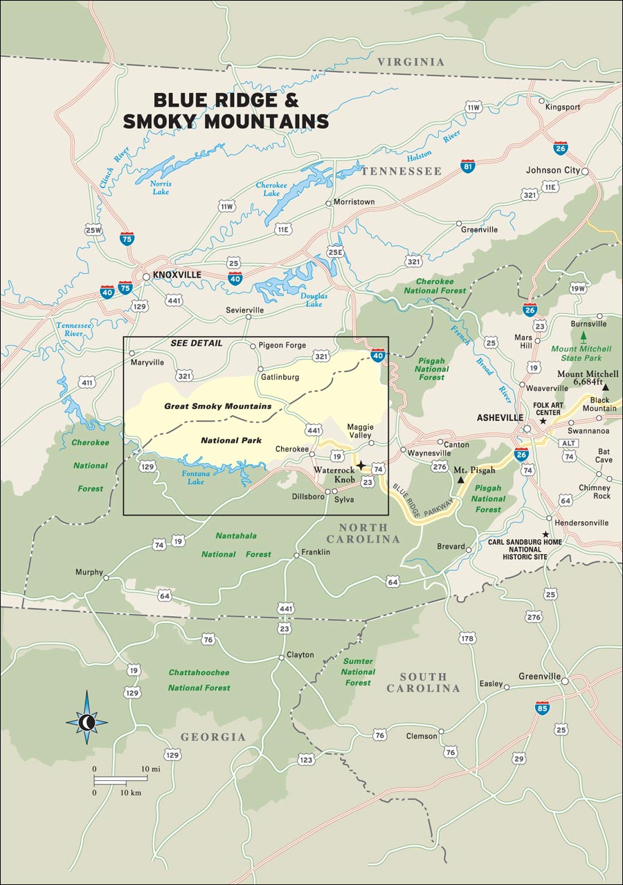
Explore Blue Ridge & Smoky Mountains
BLUE RIDGE PARKWAY IN THREE DAYS
THE PARKWAY IN BLOOM: LOOKING FOR WILDFLOWERS
THE THREE-DAY BEST OF THE SMOKIES

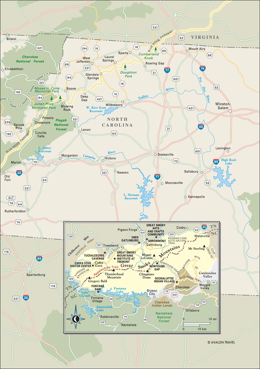
 Stretching 469 miles from Shenandoah National Park in Virginia to the Great Smoky Mountains National Park in North Carolina, the Blue Ridge Parkway is often billed as “America’s favorite scenic drive.” This beautiful mountain byway is in many ways an engineering wonder: The Linn Cove Viaduct, one of the road’s most photographed scenes, is only one of six viaducts, 26 tunnels, and 168 bridges on the Parkway.
Through North Carolina, the Parkway courses along the highest peaks east of the Mississippi River, curling around an International Biosphere Reserve at Grandfather Mountain and passing in the shadow of Mount Mitchell, the highest mountain in the East at 6,784 feet. From there it circles around the city of Asheville, which grew prosperous courting northeastern millionaires like George Vanderbilt, then into the beautiful wilderness of the Pisgah and Nantahala National Forests.
The Parkway ends at the Oconaluftee River entrance to the Great Smoky Mountains National Park, which straddles the border between North Carolina and Tennessee. The Smokies, too, boast some of the highest mountains in the East, with 16 peaks reaching over 6,000 feet. The park has more than half a million acres of forest, making it one of the largest unbroken wilderness areas on the East Coast, and its biodiversity is so great that some scientists consider walking from the park’s lowest to highest elevation to be ecologically equivalent to traveling the 2,000 miles between the start point of the Appalachian Trail in Georgia and its end in Maine.
 |
 |
The Blue Ridge Parkway is the most-visited unit of the National Park Service with some 20 million motorists coursing along its curves annually, and the Great Smoky Mountains National Park is the country’s most-visited national park with 10 million visitors a year. Being within a two-day drive of half the U.S. population ensures the popularity of both parks but also speaks to the necessity of minimizing human impacts on a much-beloved landscape.
Those impacts can be seen everywhere, as the cities and towns that surround both parks grow larger and busier every year. Asheville has undergone substantial revitalization in recent years, while on the Tennessee side of the Smokies the growth of tourist towns like Gatlinburg and Pigeon Forge seems limited only by the protected land that borders them. Nevertheless, the towns add their own special character to these mountains, offering insight into the heritage of the people who have lived and continue to live here.
 |
 |
Stretching from North Carolina’s northwest corner south to the mining regions around Spruce Pine and Little Switzerland, the High Country is a vast area of mountainous landscape hugging the Blue Ridge Parkway from Cumberland Knob to Mount Mitchell. The region is defined in large part by tourism, particularly in the area around Blowing Rock and Boone, as well as by quiet rural landscapes and villages like those found below the slopes of Bluff Mountain.
The only city for miles around, Asheville wears its mountain urbanism like a mantle, sporting a revitalized downtown historic district loaded with preserved art deco architecture and an arts scene that is at once funky and fine. It is a city where anything goes, and its casual atmosphere is a reflection of the fact that most people who live here and visit here are looking for a metropolis in a land of milk and honey, which it may very well be, bordered as it is by the Black Mountains to the north and the Smokies to the west.
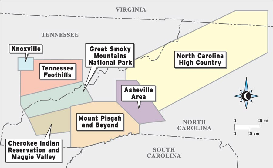
Perhaps the real land of milk and honey is in the region around Mount Pisgah, whose name actually comes from the Bible’s book of Deuteronomy, in which the Lord shows Moses the Promised Land from the sacred mountain. The landscape around Mount Pisgah and to the south is loaded with wilderness, being home, in fact, to North Carolina’s largest wilderness area, the Shining Rock Wilderness. Yet even in the midst of all the lush forested mountainsides are thriving little towns with arts scenes that will amaze you.
In the midst of the Qualla Boundary, as the Cherokee Indian Reservation is known, is Cherokee. Situated along the banks of the Oconaluftee River, this is the home of the Eastern Band, the descendants of those who managed to avoid taking the tragic Trail of Tears west to what is now Oklahoma. Cherokee’s proximity to the Great Smoky Mountains National Park has given it a burgeoning tourism industry based in large part on the heritage of its people, who still practice the arts of their ancestors and even speak, read, and write the tribe’s native tongue.
The half a million acres of the Great Smoky Mountains National Park are a wilderness wonderland waiting to be discovered, quite literally. Though sliced by the Newfound Gap Road, much of this park is roadless, accessible only by its 800 miles of hiking trails. Here are towering mountains (by Eastern standards at least), dozens of waterfalls, beautiful mountain balds, and miles upon miles of clear trout streams, as well as a thriving wildlife population ranging from the park’s ubiquitous black bears to its more than two dozen species of salamander.
The Tennessee Foothills on the Smokies’ western edge are a landscape of contradictions. Here is the largest community of resident artisans anywhere in the United States, many of them practicing historic Appalachian crafts, yet only minutes away are some of the most over-the-top tourist attractions outside Las Vegas. This pull between past and present is a defining feature of the region and one that manages to comingle peacefully in some places, the theme park of Dollywood being a surprising example.
The largest city in east Tennessee, Knoxville is probably best known for its local music scene as well as for its significance to World War II. The nearby Oak Ridge National Laboratory was a key research site of the Manhattan Project. Home to the University of Tennessee as well as to a slowly burgeoning downtown historic district centered around the music scene of Gay Street, Knoxville today is a small but cosmopolitan Southern city on the rise.
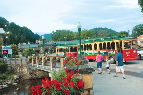
Gatlinburg Trolley, in the Tennessee Foothills
The Smokies and Blue Ridge Parkway region are busiest in both mid-summer and in fall color season, with the peak visitation months being July and October. If your goal is to avoid crowds, go in winter or early spring. While the weather will definitely be cooler (and probably downright cold at high elevations), winter and early spring will give you the opportunity to enjoy more long-distance views without leaves on the trees.
However, if your goal is to enjoy some of the blooming flora that have long attracted visitors to these mountains, you can begin to experience it in mid-May with the onset of the mountain laurel bloom. The show continues with flame azalea, followed by Catawba rhododendron, and then Rosebay rhododendron well into mid-July.
Most visitors drive to the region, but you can also fly to Knoxville or Asheville.
The Blue Ridge Parkway is organized by milepost, making it pretty easy to figure out where sights and hikes are. There are Blue Ridge Parkway visitors centers and/or services at Doughton Park, Moses H. Cone Memorial Park, Linville Falls, Crabtree Meadows, Craggy Gardens, Folk Art Center, Mount Pisgah, and Waterrock Knob. The largest cities and towns along the Blue Ridge Parkway include Mount Airy, Boone, Blowing Rock, and Asheville.
Main entry points and visitors centers for the Great Smoky Mountains National Park are at Gatlinburg and Cherokee. Main entrances to the park are on Route 441 just north of Cherokee, North Carolina, and Route 441 south of Gatlinburg, Tennessee. Stop at the Oconaluftee Visitor Center on the North Carolina side or the Sugarlands Visitor Center on the Tennessee side to obtain additional maps and directions. Request the Great Smoky Mountains Trail Map for detailed road and trail information, including directions to the less-frequented areas mentioned in this guide.
Be prepared for quick changes in weather and temperature due to elevation changes and the general rainy climate, particularly in the Smokies. Always have rain gear handy, dress in layers, have good hiking boots, and, if you plan to do a lot of hiking, energy snacks and water for the trail. Always stay on designated trails.
Keep your distance from wildlife at all times. Bring binoculars or a zoom lens, so you can enjoy and photograph wildlife without getting too close.
Three days will allow you a good overview of the Blue Ridge Parkway while still being able to drive at a leisurely pace. This road trip covers about 200 miles, starting at Cumberland Knob and ending at the highest point on the Parkway at Richland Balsam.
Pack a picnic lunch, and begin your road trip at Cumberland Knob just south of the state line between North Carolina and Virginia. Head south toward Doughton Park. Here you can take a short walk to Wildcat Rocks to enjoy spectacular views into the Doughton Park backcountry. Then drive up to the Bluff Mountain picnic area. From here, you can take a short hike up the grassy slope of Bluff Mountain to a nice view into the valleys below. Afterwards, enjoy lunch in the scenic picnic area. Continue south, being sure to check out the Appalachian crafts at the Northwest Trading Post near Milepost 260.
Next head down to E. B. Jeffries Park. If you’re a hiker, you can enjoy a one-mile trek to a beautiful waterfall here. Stay the night in Boone or Blowing Rock.
The next morning, start your day with a visit to the Parkway Craft Center at Moses H. Cone Memorial Park. Then take the easy loop hike around the beautiful shores of Price Lake to the south. You’ll get your first glimpses of Grandfather Mountain from here.
Next head across the Linn Cove Viaduct and take a side trip to Grandfather Mountain, where you’ll likely spend the rest of the afternoon exploring the Wildlife Habitat and Mile-High Swinging Bridge. If you have time at the end of the day, take one of the many hikes around Linville Falls. Spend the night at Eseeola Lodge in Linville.
As you head south of Linville Falls the next morning, be sure to make a quick stop at the Orchard at Altapass to buy some apples or locally made cider, and see if there is a bluegrass band playing on the stage. Then continue on your way, enjoying the scenery as you come into the Black Mountain range. Make a side trip here to Mount Mitchell State Park and climb the paved path to the observation tower for what will, hopefully, be 360-degree views. Make your way toward Asheville, stopping by the Folk Art Center to explore the gallery and pick up a handmade souvenir. Next it’s on to Mount Pisgah, where you can grab a late lunch at the Pisgah Inn before continuing your road trip through some of the high lonesome balds to the south. Your last stop on this journey will be at the overlook on Richland Balsam, the highest point on the Parkway at 6,047 feet.
While the vast majority of visitors who travel the Blue Ridge Parkway spend most of their time in an automobile, pausing occasionally at overlooks to take in the views, there are countless hiking trails accessible right off the Parkway that will provide you with even more remarkable scenery. Below are some of my top picks. Most of them are appropriate only for those who are avid hikers and accustomed to lots of up-and-down terrain.
This 7.5-mile trail offers a full day’s hike (you might want to arrange for a car shuttle) with almost constant long-distance views as it parallels the Parkway. The hike is accessible from various points in the Doughton Park area, but you can start at the Brinegar Cabin at Milepost 238.5.
From Brinegar Cabin, the trail passes through dense pine forest, eventually opening into a meadow with lovely views of grassy high-elevation fields. After about two more miles you’ll come to one of the prettiest stretches along the trail as you gain your first view of mountain summits stretching out endlessly in front of you. Then you’ll proceed through boulder fields, past the developed area around the Doughton Park Coffee Shop, and ascend into beautiful woods loaded with rhododendron. Past the picnic area the trail is wide and sunny, crossing a broad meadow that, in early summer, will likely be alive with wildflowers. At the summit, roughly 3.5 miles into your trek, you’ll enjoy more long-distance views across the Blue Ridge and down into the cove of Grassy Gap.
If you choose to continue beyond the summit you’ll enjoy ever-increasing long-distance views as you ascend a rough cliff overlooking the steep walls of Cove Creek Valley and experience stunning vistas with the final one coming at the Basin Cove Overlook (Milepost 244.7), which provides a view of the barren granite face of Stone Mountain and is the end of your hike.
The entire length of the Tanawha Trail is more than 13 miles, requiring a long day of fast-paced hiking, but it’s worth it if you’re an experienced hiker. This trail will not only offer you the best views of the Linn Cove Viaduct, but it will also provide regular opportunities for long-distance vistas, making every uphill climb rewarding. The trail begins at the Beacon Heights parking area at Milepost 304.8.
Because the Tanawha Trail traverses the fragile ecosystem of Grandfather Mountain it is elaborate in much the way the Linn Cove Viaduct is, crossing extravagant arching bridges and long stretches of boardwalk to prevent hikers from damaging the flora below. In fact, this single trail cost almost $250,000 to build.
If you’d like to hike some of the trail but don’t have time to take in the full length, you can hike from Wilson Creek overlook to Rough Ridge. This section offers several viewpoints of the Linn Cove Viaduct.
There are several trails of varying lengths at Linville Falls (Milepost 316.3), all of them accessible from behind the Linville Falls Visitors Center. The hiking opportunities range from short walks to trails of up to a mile, providing many different viewing opportunities of Linville Falls and Linville Gorge.
One of the best is the hike to Chimney View and Erwin’s View. Chimney View has two overlooks accessible via a series of steps. The upper Chimney View provides a full portrait of the upper falls and limited look at the lower. The lower Chimney View provides a panorama of the plunge basin where the Linville River curls through a tunnel of limestone, swirling into white foam, before dropping again at the lower falls. At Erwin’s View, you’ll enjoy a full panorama of the falls.
Accessible at Milepost 364, the Craggy Pinnacle Trail offers a trek of just under a mile to the top of a heath bald known as Craggy Pinnacle. To have the full experience of Craggy, hike the trail in late May through June to see the mountain’s tremendous lavender displays of Catawba rhododendron. At the summit of Craggy Pinnacle (5,892 ft.), you’ll be treated to 360-degree views of the surrounding mountains as well as some good photographic opportunities of the Parkway both south and north.
Accessible from Milepost 407.7, the hike to the summit of Mount Pisgah is just over a mile and a half. The trail starts out mostly level and full of wildflowers such as lilies, trillium, and goldenrod. A cascading spring greets you after half a mile, then the trail begins to ascend and grow steeper, requiring some scrambling over rocks and tree roots. Hundreds of rock steps lead up to the 360-degree view at the top of Mount Pisgah, where the elevation reaches 5,721 feet. From the wooden viewing platform—on a clear day—you’ll enjoy a blue sea of mountains as far as the horizon.
If you want to see some of the best views along the Parkway, then take a steep but relatively short hike of just under a mile to the top of Waterrock Knob Trail at Milepost 451.2.
A steep quarter mile on a paved trail takes you to the visitor platform, but don’t stop there: The views from the summit of Waterrock Knob (6,292 ft.) are worth the effort. New views lurk around every corner as you climb, and from the top you’ll see the summits of Clingmans Dome (6,643 ft.), Mount LeConte (6,593 ft.), and Mount Guyot (6,621 ft.), the highest peaks in the Great Smoky Mountains National Park.
Traveling the Blue Ridge Parkway from top to bottom is one of my favorite ways to take a relaxing, laid-back journey, and while most motorists on the Parkway do just sections of the famous byway or drive from one end to the other in a couple of days, to truly experience all this great American roadway has to offer you need to take your time. Here’s a 10-day itinerary for traveling the Parkway from where it crosses into North Carolina at Cumberland Knob (Milepost 217.5) to its end at Cherokee (Milepost 469).
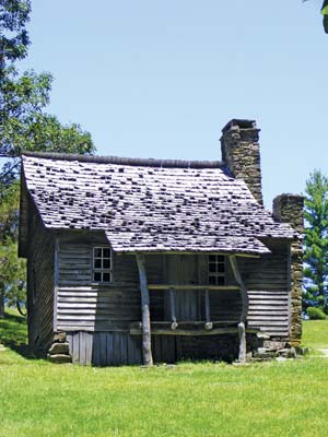
Begin your journey at Cumberland Knob and head south for several miles, enjoying the long blue views into the North Carolina Piedmont to the southeast and into the land of Christmas tree farms to the west. Take a side trip at Milepost 230 toward Roaring Gap to Stone Mountain State Park, and get an up-close glimpse of the bald-faced mountain you’ve likely been watching from the Parkway. Then get back on the Parkway, heading toward Doughton Park. Stop by the Brinegar Cabin for insights into what Appalachian life was like at the turn of the 20th century. Check in to the Bluffs Lodge on Bluff Mountain in time to watch the sunset from the porch.
The next morning, rise early and take one of the many long and beautiful hikes offered at Doughton Park, whether that’s the Bluff Mountain Trail or one of the many backcountry trails in Basin Cove. At the end of a long day of hiking you might want to take a short drive south on the Parkway along the rolling bluffs here at Doughton Park, perhaps taking in the sunset from an overlook, before taking a well-deserved rest. Stay a second night at Bluffs Lodge.
On your third day, stop by the Northwest Trading Post at Milepost 258.6 and browse through locally made crafts, and then head into Glendale Springs on Highway 16 to see the Churches of the Frescoes. Continue your side trip off the Parkway to the town of West Jefferson to visit its many art galleries. Don’t forget to pick up some locally made cheese at the Ashe County Cheese Company while you’re there. If you have some extra time, drive up to the top of nearby Mount Jefferson and take a hike to a view. Spend the night at the Rocking Chair Inn just outside West Jefferson.
Rise early for a brisk hike at E. B. Jeffries Park (Milepost 272). The Cascades Trail will take you about a mile downhill to incredibly up-close views of a gorgeous waterfall. Next head into Boone for some browsing at the Mast General Store and other shops along the town’s Main Street before taking in the outdoor drama Horn in the West. Make the Village Inns of Blowing Rock your home base for your two-day tour of the Boone and Blowing Rock area.
On your fifth day, start off with a visit to the Parkway Craft Center at Moses H. Cone Memorial Park, and then stroll around some of the park’s 25 miles of carriage trails. Then head a few minutes south for an easy, level hike around Price Lake at Julian Price Memorial Park. Spend the afternoon enjoying the shops in nearby Blowing Rock.
Today you’ll get to drive across the Parkway’s most famous icon, the Linn Cove Viaduct. Stop at the Linn Cove Viaduct Visitor Center to learn about this bridge’s unique construction. Then take a side trip to Grandfather Mountain, where you will easily spend the rest of the day exploring the park’s Nature Museum and Wildlife Habitat (where you can feed the resident black bears) and crossing the Mile-High Swinging Bridge. If you have the time, Grandfather Mountain also has several lovely hiking trails. Stay the night at the luxurious Eseeola Lodge in Linville.
Next morning, start the day with a relatively easy hike on one of the trails at Linville Falls to see incredible views of the plunging cascade and the gorge that surrounds it. From here head south and stop by the Orchard at Altapass to buy some locally harvested fruit and check out the region’s geology at the Museum of North Carolina Minerals (Milepost 331). Take a quick jaunt into Little Switzerland, visit the Swiss Shops, and enjoy lunch with a view at The Switzerland Inn. Then continue south to Mount Mitchell State Park to enjoy views from the highest peak east of the Mississippi at 6,684 feet above sea level. If you’re up for some rugged camping, stay the night at Mount Mitchell State Park; otherwise head back toward Little Switzerland for the evening for an overnight at the Switzerland Inn.
Continue your journey along the Parkway as it winds its way through the towering Black Mountains. Stop for a quick but steep hike to the top of Craggy Pinnacle, a heath bald offering more 360-degree views. Then spend the rest of the afternoon exploring the artistry of local craftspeople at the Folk Art Center and making a trip into Asheville to visit the galleries downtown. Spend the night at one of the bed-and-breakfasts in Asheville’s Montford District, perhaps the Black Walnut Bed and Breakfast.
If you’re curious about what the inside of the largest private residence in North America looks like, you might want to spend the day at Biltmore, the sprawling estate George Vanderbilt built at the turn of the 20th century. It will require a full day. If you prefer to keep exploring the great outdoors, however, then continue south to Mount Pisgah (Milepost 408.6), where you can take a hike to the summit or just enjoy a lunch with incredible views at the Pisgah Inn. Then continue south to the area known as Graveyard Fields for a relatively easy hike to view Yellowstone Falls. Stay overnight at the Pisgah Inn.
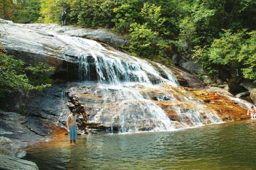
Yellowstone Falls at Graveyard Fields
On the final day of your journey you will likely enjoy some of the best views as you cross the highest point on the Parkway (6,047 ft.) at Richland Balsam. Then head to Waterrock Knob (Milepost 451.2) for even more stunning vistas from the observation platform here or at the summit if you don’t mind a steep hike. The last leg of your journey on the Parkway will take you through the Cherokee Indian Reservation to the roadway’s end in the town of Cherokee. Here you should definitely pay a visit to the Museum of the Cherokee Indian as well as the Qualla Arts and Crafts Mutual across the street. The best lodgings in Cherokee are at Harrah’s Casino.
Sadly enough, most people do the Great Smoky Mountains National Park in a day. You should give it at least three days to get a true feel for what this half-million-acre park has to offer as well as to get a taste of the history and culture of the surrounding communities. Here are my top picks for a long-weekend tour.
Start your day in Cherokee. Visiting the Museum of the Cherokee Indian will give you a grounding in the human history of the Smokies before entering the national park. Then take the Newfound Gap Road across the park, a 30-mile trek from Cherokee to Gatlinburg. Along the way be sure to stop and visit the Mountain Farm Museum and Mingus Mill to learn about the European American settlers who called these mountains home. From the Newfound Gap Road you can also take a spur road to Clingmans Dome, the highest mountain in the park at 6,643 feet, and then enjoy the view from Newfound Gap. Your road trip will end in Gatlinburg, where you can spend the evening strolling the town. Be sure to enjoy a nighttime ride up the Gatlinburg Sky Lift.
The next morning, start your day with an auto tour along the Roaring Fork Motor Nature Trail, a less-traveled part of the national park that will give you the opportunity to go inside several historic homes that once made up the Roaring Fork community. You may also see some black bears along this route. Exit the park at the end of your tour, and spend the afternoon exploring the Great Smoky Arts and Crafts Community in Gatlinburg, the largest resident gathering of independent artisans in the United States.
On your last day, head back into the national park at the Sugarlands entrance at Gatlinburg, and take a right onto Little River Road, a winding journey of about 25 miles along the scenic Little River. Stop for a moderate paved hike to the lovely cascade of Laurel Falls, and then continue your journey west to Cades Cove. Cades Cove has the park’s largest collection of preserved Appalachian structures, and you can take an 11-mile loop tour of the beautiful valley. This is also one of the best places in the park to see black bears, particularly if you visit close to sunset.
While it’s true that most of the 10 million people who enter the Great Smoky Mountains National Park each year only get out of their cars to photograph the views, these mountains can’t be fully appreciated without some work—some very fun work, however. If you’re an active outdoors person, try these recommendations for exploring the Smokies in four days—while barely setting foot in your car.
You’ll start your fun in the Smokies by getting to know the rivers...and their rapids. Sign up with a local outfitter to go white-water rafting down the Pigeon River on the national park’s northern border. The rapids on the Pigeon River range from Class I to Class IV, so you’ll get a good mix of adventure without feeling like you’re taking your life into your hands the whole time. Plus, you’ll have some time to just float and enjoy the riverside scenery on the park’s northern border. You’ll likely be pretty tired after paddling for a couple of hours, so spend the rest of the afternoon taking a quiet scenic drive into Greenbrier Cove, a gravel back road just north of Gatlinburg leading into one of the national park’s little-traveled areas. This is also the region of the Smokies where Dolly Parton’s ancestors once lived.
On the second day, you’ll take an overnight hike to the summit of Mount LeConte. You can backpack if you want, but for a truly unique experience, consider making reservations at the hike-in only LeConte Lodge. While there are more than half a dozen trails you can take to reach LeConte’s summit (6,593 ft.), the most scenic is the Alum Cave Bluffs Trail. This is a steep 5.5-mile hike that will take you through the strange natural tunnel of Arch Rock, past some incredible views from the heath balds of Inspiration Point, and then to the bizarre feature of Alum Cave Bluffs, where it, quite literally, never rains. The last leg of the hike will be a continual uphill rewarded by regular long-distance mountain views and will involve some scrambling along rock ledges with steel cables to help you keep your balance. When you arrive at the summit, you can spend the night in a rustic cabin (no electricity or running water) at LeConte Lodge. They’ll also fix you a hearty hiker’s dinner. Just make sure to make reservations first.
Most of your third day will be spent hiking down Mount LeConte and, if you’ve arranged for a hiker’s shuttle, you can take a different route on the way down. Consider the Rainbow Falls Trail or Trillium Gap Trail, both of which lead down into Roaring Fork. Rainbow Falls is an incredibly steep downhill trek with a lot of loose rock, but it will take you past the cascade of Rainbow Falls. For a little bit easier but longer hike, take Trillium Gap. This is also the trail used by the llamas who supply LeConte Lodge, and you might meet them on your way down. The trail will also take you under (yes, I said under) Grotto Falls. No doubt about it, when you reach the bottom you’ll be bone tired. Take the auto tour around the Roaring Fork Motor Nature Trail, and then hit the hay!
You’ll probably be pretty tired on the final day of this adventure, so we’ve saved the most relaxing for last. Sleep in if you like, and then sign up for a trail ride at Smoky Mountain Riding Stables just north of Gatlinburg. Saddle up your horse and join other riders on a tour of the national park around Greenbrier Cove. A two-hour journey will take you up some steep mountain terrain (but at least you’re not doing the hiking this time!), through mountain streams, and past some beautiful forest scenery before you have to head home again.
One thing that’s easy to overlook in the Smokies, if you’re just speeding through on a quick scenic driving tour, is the human history. Long before the Great Smoky Mountains National Park was established, thousands of people, both Native and European American, called these mountains home. If you’d like to learn some of the history of the Smokies, here’s your itinerary.
Start your journey in Cherokee, where you’ll spend a full day learning about the Native American culture of the Smokies. Start your tour at the Museum of the Cherokee Indian to learn about the native people who have lived in these mountains for at least 11,000 years, and then browse through some of the Cherokee’s locally made river-cane and white-oak baskets, pottery, beadwork, and woodcarving at the Qualla Arts and Crafts Mutual. Then head up to the Oconaluftee Indian Village to see Cherokee craftspeople working their trades. Close the day with an evening viewing of the outdoor drama Unto These Hills, which deals with the history of the Cherokee and the Trail of Tears.
On your second day, head north to the Cataloochee Valley, which was once the most populous area of what is now the Great Smoky Mountains National Park. Here you will see a quiet valley of long-abandoned houses, a school, a church, and several barns. You may also get the extra treat of seeing some of the park’s elk. When you’ve completed your tour of the valley, head over to the Tennessee side of the park to tour the Roaring Fork Motor Nature Trail, which will take you on a short loop tour of a small community that existed above present-day Gatlinburg (originally known as White Oak Flats).
On your final day, get up at dawn and head into Cades Cove, in the southwestern corner of the park, and rent a bicycle at the Cades Cove Campground store. (Try to hit Cades Cove on a Wednesday or Saturday, when the cove is closed to automobiles until 10 A.M.) Spend the morning on a leisurely bike ride through the largest collection of preserved Appalachian farm structures in the park, and see some mill demonstrations at Cable Mill. If you get out there early enough you’ll likely spot some black bears hanging out in the apple trees, too—quite a memory to take home with you that afternoon.