
Preoccupied by the fjords and the long road to Nordkapp, few tourists are tempted to explore central Norway. The Norwegians know better. This great chunk of land, trapped between Sweden and the fjords, boasts some of the country’s finest scenery, with the forested dales that trail north and west from Oslo heralding the region’s mountain passes and rearing peaks. And among much else, it’s here, within shouting distance of the country’s principal train line and the E6 – long the main line of communication between Oslo, Trondheim and the north – that you’ll find three of Norway’s prime hiking areas. These comprise a trio of mountain ranges, each partly contained within a national park – from south to north, Jotunheimen, Rondane and the Dovrefjell-Sunndalsfjella.
There are four main highways running from Oslo and its environs to the fjords. Whichever one you choose, allow a little time to appreciate the wonderful scenery and to muse on the ingenuity of Norway’s road builders – and the difficulty of communication before they set to work: until well into the 1970s, a trip to Oslo from many a fjordland village could take at least a couple of days. Among these four major highways, the E6 is the busiest, running up the Gudbrandsdal valley past several historic sights and within easy striking distance of a battery of national parks, most notably Jotunheimen, Rondane and Dovrefjell-Sunndalsfjella. Of the three, Jotunheimen is the harshest and most stunning, with its string of icy, jagged peaks; the Dovrefjell-Sunndalsfjella is more varied with severe mountains in the west and open moors and rounded ridges in the east; while Rondane, a high alpine zone, has more accessible mountains and low vegetation. Each of the parks is equipped with well-maintained walking trails and DNT huts, two of which – Rondvassbu and Gjendesheim – are ideal for hiking expeditions deep into Rondane and Jotunheimen respectively. For Dovrefjell-Sunndalsfjella, the easiest place to start is Kongsvoll, on both the E6 and the train line. The E6 also passes reasonably near to the intriguing old copper-town of Røros and, even better, it’s the starting point for Highway 15 and the E136, two magnificent roads that thread through the mountains to the fjords (see Chapter 4).
On the other hand, the E16 is the most direct route to the fjords, a 350km yomp up the Valdres valley and over the Filefjell mountain pass to Lærdal, firmly in fjord country and at the start of the series of long tunnels that enable the E16 to fast-track west to Flåm and ultimately Bergen. The long lakes and wooded hills of the Valdres valley make for a delightful drive and on the way you’ll shoot past several stave churches, though the most beautiful and certainly the most famous is beyond the valley, over the Filefjell pass, at Borgund.
Further south, the first part of Highway 7, the long haul up the Hallingdal valley, is perhaps the least diverting way to get to the fjords, but later on the road does traverse the wonderfully wild Hardangervidda mountain plateau. You can also fork north from Highway 7 along Highway 50, which thunders down the dramatic Aurlandsdalen valley bound for the fjords at Aurland, near Flåm. Finally, there’s the E134 to Odda and Lofthus, which has the advantage of passing through the attractive former silver-town of Kongsberg and within a whisker of Dalen, with its excellent hotel, before making a dramatic defile across the Hardangervidda and then proceeding up and over the wild and desolate Haukelifjell mountain pass.
In terms of accommodation, roadside campsites are commonplace, there’s a reasonable supply of HI hostels, and every town and village has at least one hotel or guesthouse.
 Zoom top
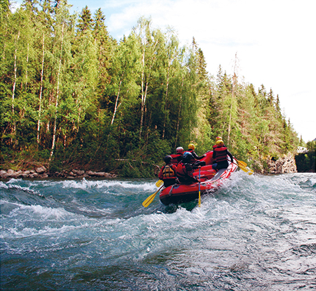
WHITEWATER RAFTING, RIVER SJOA
Highlights
1 Whitewater rafting, Sjoa Brave some of Norway’s most exciting whitewater-rafting on the River Sjoa.
2 Lake Gjende A boat trip along one of Norway’s most beautiful lakes provides a scenic introduction to the mighty Jotunheimen mountains.
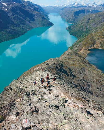
3 Hike the Besseggen ridge Norway at its wildest: sample the magnificent scenery of the Jotunheimen Nasjonalpark on this classic walk, one of the country’s most celebrated.
4 Kongsvold Fjeldstue This lovely hotel occupies a tastefully restored complex of old timber buildings, and is convenient for exploring the Dovrefjell-Sunndalsfjella National Park.
5 Borgund stave church One of the best preserved and most harmonious of Norway’s 28 remaining stave churches: admire the intricacy of its construction and the intimacy of its decoration.
6 Kongsberg This lovely little town is home to Norway’s most imposing Baroque church.
7 Dalen Hotel Immaculately restored 1890s hotel in a quiet country town halfway between Oslo and the fjords.
GETTING AROUND: CENTRAL NORWAY
By train Trains shuttle along the two main rail lines that cross central Norway: the Oslo–Bergen line shadows Highway 7 until just after Geilo, while the Oslo–Trondheim line passes through Hamar, Lillehammer and Dombås, the junction for the superbly scenic run down to the fjords at Åndalsnes on the Rauma branch line. An alternative train route from Oslo to Trondheim dodges Lillehammer and Dombås, but includes Røros.
By bus Nor-Way Bussekspress buses (![]() nor-way.no) ply the E6 as well as most of the E16 and the
E134, but once you get onto the minor roads, including Highway 7, the
bus system thins out and travelling becomes much more difficult without
your own vehicle.
nor-way.no) ply the E6 as well as most of the E16 and the
E134, but once you get onto the minor roads, including Highway 7, the
bus system thins out and travelling becomes much more difficult without
your own vehicle.
North to Kongsvoll
Heading north from Oslo, both the E6 and the railway thump across the lowlands, clipping the international airport at Gardermoen before following the east bank of Lake Mjøsa to skip past the amenable little town of Hamar. Thereafter, it’s a short haul to ski-crazy Lillehammer, home to one of the best of Norway’s many open-air folk museums, and then road and rail sweep on up the Gudbrandsdal valley, within sight of a string of modest little towns and villages, the first significant attraction being Ringebu stave church. Pushing on, it’s just a few kilometres more to Sjoa, a centre for whitewater rafting, and then, a little further north, Otta, an undistinguished town but one that is within easy reach of two particularly magnificent national parks, Jotunheimen and Rondane. Further north still is the rugged Dovrefjell-Sunndalsfjella Nasjonalpark, which is most pleasingly approached from tiny Kongsvoll. All three parks are networked by an extensive and well-planned system of hiking trails.
From Kongsvoll, Trondheim is within comfortable striking distance; alternatively, you can detour east to Røros, a fascinating old copper-mining town on the mountain plateau that stretches across to Sweden.
Eidsvoll-bygningen
House and visitor centre April & Sept
Tues–Fri 10am–3pm, Sat & Sun noon–5pm; May–Aug daily 10am–5pm;
Oct–March Wed–Fri 10am–3pm, Sat & Sun noon–5pm • House 75kr;
visitor centre free • ![]() eidsvoll1814.no • Eidsvoll-byningen is 2km off the E6 (just
follow the signs), and about 1.5km from Eidsvoll Verk train station;
trains run from Oslo S (hourly; 50min) and Hamar (hourly; 1hr), though
you need to change at Eidsvoll
eidsvoll1814.no • Eidsvoll-byningen is 2km off the E6 (just
follow the signs), and about 1.5km from Eidsvoll Verk train station;
trains run from Oslo S (hourly; 50min) and Hamar (hourly; 1hr), though
you need to change at Eidsvoll
About 70km north of Oslo, in a countryside setting just to the south of the industrial town of Eidsvoll Verk, is Eidsvoll-bygningen (Eidsvoll Manor House), a charming and spacious old manor house that gives a real insight into the tastes of Norway’s early nineteenth-century upper class. In its own little park with a river running down below, this two-storey timber house has just over thirty rooms, with what were once the owners’ living areas on the first floor, beneath the servants’ quarters and above the basement kitchens. The main entrance hall is in the Neoclassical style much favoured by the Dano–Norwegian elite, its columns a suitably formal introduction to the spacious suites that lie beyond. The library is well stocked, and there’s a billiard room and a smoking room, as well as a string of elegant dining rooms and bedrooms. Oriental knick-knacks and English furniture appear throughout, and the occasional mural depicts Greek mythological figures. There’s also an obsession with symmetry: doors were camouflaged and false windows created to avoid breaking up the architectural regularity whenever it was threatened. The house was owned by the Ankers family, who made their money from the local ironworks – hence the splendid cast-iron stoves.
It’s a delightful ensemble, but the house owes much of its present appearance – perhaps even its survival – to its historical significance (see Eidsvoll-bygningen and the Constitution of 1814) rather than its aesthetics. One of the family, Carsten Ankers, converted the upper storey of his home into premises for the National Assembly, comprising a handful of administrative offices plus the Room for the Constitutional Committee, where the original wooden benches have survived along with various landscape paintings. There’s a rusticated modesty to it all which is really rather charming, and a painting of Venus has been put back in the room after years of being shunted up and down the adjoining corridors: after prolonged discussion, it had originally been removed because the representatives considered it an erotic distraction. For more on the evolution of democracy in general and the Norwegian Constitution in particular, drop by the visitor centre just down from the house near the river.
EIDSVOLL-BYGNINGEN AND THE CONSTITUTION OF 1814
Carsten Ankers (1747–1824) was a close friend and ally of the Danish crown prince Christian Frederik, a connection that has given Eidsvoll national importance. Towards the end of the Napoleonic Wars, the Russians and British insisted the Danes be punished for their alliance with the French, and proposed taking Norway from Denmark and handing it over to Sweden. In an attempt to forestall these territorial shenanigans, the Danes dispatched Christian Frederik to Norway, where he set up home in Carsten Ankers’ house in 1813, and proceeded to lobby for Norwegian support. In April of the following year more than a hundred of the country’s leading citizens gathered here near Eidsvoll to decide whether to accept union with Sweden or go for independence with Christian Frederik on the throne. The majority of this National Assembly chose independence, and set about drafting a liberal constitution based on those of France and the United States.
Predictably, the Swedes would have none of this. Four years earlier, the Swedes had picked one of Napoleon’s marshals, Jean-Baptiste Bernadotte, to succeed their previous king who had died without an heir. As King Karl Johan, Bernadotte was keen to flex his military muscles and, irritated by the putative National Assembly, he invaded Norway in July 1814. Frederik was soon forced to abdicate and the Norwegians were pressed into union with Sweden, though Karl Johan did head off much of the opposition by guaranteeing the Norwegians a new constitution and parliament, the Storting.
Hamar
Set midway around the eastern shore of Lake Mjøsa, some 130km from Oslo, HAMAR is a pleasant if undemanding town of 29,000 inhabitants, whose centre rustles up a scattering of substantial nineteenth-century buildings, including a large and really rather imposing train station. In fact, the rail line – and its embankment – currently sit between the town centre and the lake, though there are ambitious plans to re-route the railway further out on the lake. In the meantime, it’s easy to unwind here in Hamar, which is at its prettiest in the little park in between Strandgata and the railway embankment, and on the old jetty where the vintage Skibladner docks during the summer. The town also possesses one notable sight: the Hedmarksmuseet.
Before the railroad arrived in the 1880s, the lake was an important transport route, crossed by boats in summer and by horse and sleigh in winter. It’s also halfway country: the quiet settlements around the lake give a taste of small-town southern Norway before the E6 plunges into the wilder regions further north.
DS SKIBLADNER
Hamar is as good a place as any to pick up the 130-year-old paddle steamer, the DS Skibladner (![]() 61 14 40 80,
61 14 40 80, ![]() skiblander.no), which
shuttles up and down Lake Mjøsa during
the summer offering wide views over rolling forested hills to east and
west. Travellers heading north may find the trip to Lillehammer tempting
at first sight, but the lake is not particularly scenic, and after four
hours on the boat you may well feel like jumping overboard. The best bet
is to take the shorter ride to Eidsvoll instead.
skiblander.no), which
shuttles up and down Lake Mjøsa during
the summer offering wide views over rolling forested hills to east and
west. Travellers heading north may find the trip to Lillehammer tempting
at first sight, but the lake is not particularly scenic, and after four
hours on the boat you may well feel like jumping overboard. The best bet
is to take the shorter ride to Eidsvoll instead.
Sailings run from late June to mid-August. On Tuesdays, Thursdays and Saturdays the boat makes the return trip across the lake from Hamar to Gjøvik and on up to Lillehammer (just under 8hr; 320kr); on Wednesdays, Fridays and Sundays it chugs south to Eidsvoll and back (4hr 30min; 280kr); there’s no Monday service. Sailing times are available direct or at any local tourist office. Tickets are bought on board; one-way fares cost a little over half the return fare. In Hamar, the Skibladner jetty is handily located about 600m to the west of the train station along the lakeshore. In Lillehammer, it’s on the west side of the lake, across the bridge from the centre of Lillehammer, beside the E6.
Hedmarksmuseet
Domkirkeodden • Late May to late June Tues–Sun 10am–4pm;
late June to mid-Aug daily 10am–5pm; late Aug Tues–Sun
10am–4pm • 100kr • ![]() hedmarksmuseet.no
hedmarksmuseet.no
Unlikely though it may seem today, Hamar was once the seat of an important medieval bishopric, and the battered remains of its Romanesque-Gothic Domkirke (Cathedral), now protected by a glass and steel superstructure – the Hamardomen – are stuck out on the Domkirkeodden (Cathedral Point), a low, leafy headland about 2km west of the centre. The cathedral is thought to have been built by the “English pope” Nicholas Breakspear, who spent a couple of years in Norway as the papal legate before becoming Adrian IV in 1154, but the building, along with the surrounding episcopal complex, was ransacked during the Reformation, and local road-builders subsequently helped themselves to the stone.
The cathedral ruins have now been incorporated into the rambling Hedmarksmuseet (Hedmark Museum), which also contains an archeological section, the remains of the bishop’s palace, a display of vintage photographs of the town and its surroundings, and an open-air folk museum. The latter holds around sixty buildings collected from across the region and, although it’s not as comprehensive as the one in Lillehammer, it does contain several particularly fine buildings, the oldest of which are clustered in the Hedmarkstunet section.
The most scenic approach to the Hedmarksmuseet is along the pleasant lakeshore footpath that stretches 2km north from the train station.
ARRIVAL AND DEPARTURE: HAMAR
By train Hamar train station is near the lakeshore on the southeast corner of the downtown grid. It’s the starting point of a branch line that leads to Røros, a fine ride over hills and through huge forests.
Destinations Lillehammer (hourly; 40min); Oslo (hourly; 1hr 20min); Oslo Gardermoen (hourly; 1hr); Røros (3–6 daily; 3hr 30min); Trondheim (2–4 daily; 5hr 15min).
By bus The main bus station is a couple of minutes’ walk away to the east of the train station. Nor-Way Bussekspress runs the following services:
Dag og Nattekspressen (#142) to: Lillehammer (2 daily; 1hr); Oslo (2 daily; 2hr); Oslo Gardermoen (2 daily; 1hr 20min); Otta (2 daily; 3hr 20min).
Gudbrandsdalekspressen (#148) to: Lillehammer (Mon–Fri 1 daily; 1hr); Oslo (Mon–Fri 1 daily; 2hr); Otta (Mon–Fri 1 daily; 3hr 20min).
ACCOMMODATION
 Quality Hotel Astoria Torggata 23
 ![]() 62 70 70 00,
62 70 70 00, ![]() choicehotels.no.
Plumb in the centre of town, with its best rooms overlooking the
main square, this medium-sized and noticeably friendly chain
hotel is decorated in bright and cheerful colours. Breakfast is
taken in a mock-up of a bondstua
(farmer’s house) – all a little daft perhaps, but still somehow
rather endearing. 1400kr, sp/r 1100kr
choicehotels.no.
Plumb in the centre of town, with its best rooms overlooking the
main square, this medium-sized and noticeably friendly chain
hotel is decorated in bright and cheerful colours. Breakfast is
taken in a mock-up of a bondstua
(farmer’s house) – all a little daft perhaps, but still somehow
rather endearing. 1400kr, sp/r 1100kr
Scandic Hamar Vangsvegen 121 ![]() 21 61 40 00,
21 61 40 00, ![]() scandichotels.com.
Located in a large modern block on the northeast edge of the
town centre, this chain hotel may not be especially
prepossessing from the outside, but the interior has been kitted
out in a bright and well-conceived modern/minimalist style as
have the spacious bedrooms, some of which – on the top floors –
have wide views over town. Breakfasts here are first-rate too.
1600kr, sp/r 1200kr
scandichotels.com.
Located in a large modern block on the northeast edge of the
town centre, this chain hotel may not be especially
prepossessing from the outside, but the interior has been kitted
out in a bright and well-conceived modern/minimalist style as
have the spacious bedrooms, some of which – on the top floors –
have wide views over town. Breakfasts here are first-rate too.
1600kr, sp/r 1200kr
Vikingskipet motell og Vandrerhjem Åkersvikvegen 24 ![]() 62 52 60 60,
62 52 60 60, ![]() hihostels.no.
Hamar’s all-year HI hostel occupies a modern two-storey
motel-style timber building about 1km east along the lakeshore
from the train station. It’s in the middle of nowhere, just
across from the massive skating arena, the Vikingskipet, built
for the 1994 Winter Olympics in the shape of an upturned Viking
ship. There’s a café, a laundry and self-catering facilities.
All rooms are en suite. Dorms 410kr, doubles 840kr
hihostels.no.
Hamar’s all-year HI hostel occupies a modern two-storey
motel-style timber building about 1km east along the lakeshore
from the train station. It’s in the middle of nowhere, just
across from the massive skating arena, the Vikingskipet, built
for the 1994 Winter Olympics in the shape of an upturned Viking
ship. There’s a café, a laundry and self-catering facilities.
All rooms are en suite. Dorms 410kr, doubles 840kr
EATING
Hot & Spicy Torggata 21, cnr Enggata ![]() 62 52 02 60,
62 52 02 60, ![]() hot-andspicy.com.
Handily located in the centre of town, this cheerfully decorated
Chinese/Thai restaurant is an informal, family-run place, where
the service is fast and efficient and main courses are priced
140–190kr.
Mon & Wed–Sat 3–11pm, Sun 2–10pm; closed Tues.
hot-andspicy.com.
Handily located in the centre of town, this cheerfully decorated
Chinese/Thai restaurant is an informal, family-run place, where
the service is fast and efficient and main courses are priced
140–190kr.
Mon & Wed–Sat 3–11pm, Sun 2–10pm; closed Tues.
Pepperkvaerna Mat og Vinhus Torggata 23 ![]() 62 70 70 30.
Attached to the Quality Hotel Astoria, this neatly turned-out restaurant does
not look particularly outstanding but the food is absolutely
delicious with the emphasis on traditional Norwegian dishes with
added zip (and perfect sauces). They also try to source locally
– try the mountain trout with potatoes, a veritable snip at
280kr.
Mon–Thurs 5–11pm, Fri & Sat 6–11pm; kitchen till 10pm.
62 70 70 30.
Attached to the Quality Hotel Astoria, this neatly turned-out restaurant does
not look particularly outstanding but the food is absolutely
delicious with the emphasis on traditional Norwegian dishes with
added zip (and perfect sauces). They also try to source locally
– try the mountain trout with potatoes, a veritable snip at
280kr.
Mon–Thurs 5–11pm, Fri & Sat 6–11pm; kitchen till 10pm.
Lillehammer and around
LILLEHAMMER (literally “Little Hammer”), 60km north of Hamar and 190km from Oslo, is Lake Mjøsa’s largest settlement and, in winter at least, its most worthwhile destination. The town has become one of Norway’s top ski centres (see Lillehammer: winter activities), its semi-rural lakeside setting and extensive cross-country ski trails contributing to its selection as host of the 1994 Olympic Winter Games. The Lillehammer area is a popular summer holiday spot too. As soon as the weather picks up, hundreds of Norwegians hunker down in their second homes in the hills that flank the town, popping into the centre for a drink or a meal. Cycling, walking, fishing and canoeing are popular pastimes at this time of year, but however appealing the area may be to Norwegians, the countryside hereabouts has little of the wonderful wildness of other parts of Norway, and unless you’re someone’s guest or bring your own family, you’ll probably feel rather out on a limb.
Even though its centre does look a tad humdrum, Lillehammer is not a bad place to break your journey. Orientation couldn’t be easier: pretty much everything that’s happening is focused on the pedestrianized part of Storgata, which runs north from Bankgata to the tumbling River Mesnaelva, a five-minute stroll away; Kirkegata, another useful street, runs one block parallel to the west of Storgata (down the hill). Lillehammer’s three top attractions are the Kunstmuseum (Art Museum), Maihaugen open-air museum, and Aulestad, the country home of Norwegian author Bjørnstjerne Bjørnson, about thirty minutes’ drive away. It’s also one of the ports of call of the antique DS Skibladner paddle steamer as it shuttles up and down Lake Mjøsa.
LILLEHAMMER: WINTER ACTIVITIES
In preparation for the 1994 Winter Olympics, the Norwegian government spent a massive two billion kroner on the town’s sporting facilities, which are now among the best in the country. Spread along the hillsides above and near the town, they include several dozen downhill ski trails catering for everyone from beginner to expert, floodlit slopes for night skiing, ski-jumping towers and multiple chairlifts, an ice hockey arena, and a bobsleigh track. There is even a special stadium – the Birkebeiner – where skiers can hone their skills before setting off into the mountains, which are crisscrossed by 350km of cross-country ski trails. As you would expect, most Norwegians arriving here in winter come fully equipped, but it’s possible to rent or buy equipment locally – the tourist office will advise, but note that advance booking is strongly recommended.
Lillehammer Kunstmuseum
Stortorget 2, Kirkegata • Late June to late Aug daily 11am–5pm; rest
of year Tues–Sun 11am–4pm • 100kr; extra admission charge for
temporary exhibitions • ![]() lillehammerartmuseum.com
lillehammerartmuseum.com
Lillehammer’s workaday modern centre has just one top-quality attraction, the Kunstmuseum (Art Museum), housed in two adjacent buildings – one a municipal structure from the 1960s, the other a newer, flashier edifice. The gallery is renowned for its temporary exhibitions, but the small permanent collection is also very worthwhile, comprising a representative sample of the works of most major Norwegian painters, from Johan Dahl and Christian Krohg to Munch and Erik Werenskiold. In particular, look out for the striking landscapes painted by one of the less familiar Norwegian artists, Axel Revold (1887–1962). A student of Matisse and an admirer of Cézanne, Revold spent years working abroad before returning home and applying the techniques he had learned to his favourite subject, northern Norway: his beautifully composed and brightly coloured Nordland is typical. Revold also dabbled in the bizarre, as in the bold Expressionism of A Sailor’s Dream.
Maihaugen
June–Aug daily 10am–5pm; Sept–May Tues–Sun
11am–4pm • Frequent guided tours in summertime; call
![]() 61 28 89 00 • 110kr, June–Aug 150kr •
61 28 89 00 • 110kr, June–Aug 150kr • ![]() maihaugen.no • From Storgata, walk up Bankgata, turn
right onto Maihaugenvegen, and keep going, following the signs
(20min)
maihaugen.no • From Storgata, walk up Bankgata, turn
right onto Maihaugenvegen, and keep going, following the signs
(20min)
The much-vaunted Maihaugen open-air folk museum, about 1.5km southeast of the town centre, is the largest of its type in northern Europe. Incredibly, the bulk of the collection represents the lifetime’s work of one man, a magpie-ish dentist by the name of Anders Sandvig (1862–1950), who only ended up here in Lillehammer by accident: he contracted tuberculosis and moved here from Oslo to recuperate in the clear mountain air. Since Sandvig’s death, the collection has gradually been increased and Maihaugen now holds approaching 200 relocated buildings, brought here from all over the region and including several real treasures such as a charming seventeenth-century presbytery (prestegårdshagen) and a thirteenth-century stave church from Garmo. The museum has also attempted to widen its range, one recent addition being a 1970s house – bell-bottoms to the fore.
During the summertime, costumed guides give the lowdown on traditional rural life and there’s often the chance to have a go at domestic activities such as spinning, baking, weaving and pottery – good, wholesome fun. You can spend time too in the main museum building, which features temporary exhibitions on folkloric themes. Allow a good half-day for a visit and you might also want to take advantage of the free English-language guided tours when they are scheduled.
Maihaugen’s farms
Maihaugen’s key exhibits are two farms, one from Bjørnstad, the other Øygarden, both of which date from the late seventeenth century. Complete with their various outhouses and living areas, the two comprise 36 buildings, each with a specific function, such as food store, sheep-shed, hay barn, stable and bathhouse. This setup may have worked, and it certainly looks quaint, but it was, in fact, forced upon farmers by their tried-and-tested method of construction, laft. Based on the use of pine logs notched together at right angles, the technique strictly limited the dimensions of every building, as the usable part of the pine tree was rarely more than 8m long. Indeed, it seems likely that many farmers would have preferred to keep their winter supplies in the main farmhouse rather than in a separate store, as implied by a draconian medieval law that stated, “When a man discovers another in his storehouse … then he may kill the man if he so wishes.”
Around Lillehammer: Aulestad
Late May to Aug daily 10am–5pm; Sept to early Oct Tues–Sun 11am–4pm • 110kr • By car, head north from Lillehammer on the E6 and turn onto Highway 255 after about 4km; to get back onto the E6 heading north, follow Highway 255 from the Bjørnson house, then turn onto Highway 254, which brings you out on the E6 halfway between Lillehammer and the Ringebu church
In the hamlet of Follebu, 18km northwest of Lillehammer, is Aulestad, a good-looking villa perched on a leafy knoll that formerly belonged to Bjørnstjerne Bjørnson, who moved to Aulestad in 1875 and stayed there for the rest of his life. The house was gifted to the nation on the death of Bjørnstjerne’s widow Karoline in 1934, and is jam-packed with family mementoes. An audiovisual display inside the house gives further details on the man and his times.
BJØRNSTJERNE BJØRNSON
Bjørnstjerne Bjørnson (1832–1910) was a major figure in the literary and cultural revival that swept the country at the end of the nineteenth century. Bjørnson made his name with the peasant tales of Synnøve Solbakken in 1857 and thereafter he churned out a veritable flood of novels, stories, poems and plays, many of which romanticized Norwegian country folk and, unusually for the time, were written in Norwegian, rather than the traditional Danish. He also championed all sorts of progressive causes, from Norwegian independence through to equality of the sexes and crofters’ rights, albeit from a liberal (as distinct from leftist) viewpoint. Nowadays, however, his main claim to fame is as author of the poem that became the national anthem.
ARRIVAL AND INFORMATION: LILLEHAMMER AND AROUND
By train The Skysstasjon, on Jernbanetorget, at the foot of Jernbanegata, incorporates the train station and the bus terminal. It’s just a couple of minutes’ walk from Storgata, the main drag – walk up the hill.
Destinations Hamar (hourly; 40min); Oslo (hourly; 2hr); Oslo Gardermoen (hourly; 1hr 40min); Trondheim (2–4 daily; 4hr 30min).
By bus The bus station is housed in the Skysstasjon. Nor-Way Bussekspress run the following services:
Gudbrandsdalekspressen (#148) to: Hamar (Mon–Fri 1 daily; 1hr); Oslo (Mon–Fri 1 daily; 3hr); Otta (Mon–Fri 1 daily; 4hr 20min).
Nordfjordekspressen (#147) to: Langvatn (3 daily; 4hr 50min); Lom (3 daily; 3hr 20min); Oslo (3 daily; 3hr); Otta (3 daily; 2hr 30min); Stryn (3 daily; 5hr 50min).
By car The E6 motorway cuts along the lakeshore about 500m below – and to the west of – the centre of Lillehammer. The town’s one-way system is befuddling, but once you have reached the city centre, on-street parking is (usually) easy to find.
Tourist office In the Skysstasjon, Jernbanetorget (mid-June to mid-Aug
Mon–Sat 9am–6pm, Sun noon–5pm; mid-Aug to mid-June Mon–Fri
8am–4pm, Sat 10am–2pm; ![]() 61 28 98 00,
61 28 98 00, ![]() lillehammer.com).
Staff have information on local events and activities, can issue
a comprehensive town brochure, and will help with finding
accommodation.
lillehammer.com).
Staff have information on local events and activities, can issue
a comprehensive town brochure, and will help with finding
accommodation.
ACCOMMODATION
Clarion Collection Hotel Hammer Storgata 108 ![]() 61 26 73 73,
61 26 73 73, ![]() choicehotels.no.
Gallant and largely successful attempt by this large chain to
create a hotel with a cosy, traditional feel – from the open
fireplaces and soft pastels of the public areas to the retro,
high-gabled facade. The rooms are well equipped and comfortable
and set round a courtyard with the quieter ones to the rear.
Just west of the centre, about 5min walk from the train station.
Rates include an evening buffet meal. 1270kr, sp/r 970kr
choicehotels.no.
Gallant and largely successful attempt by this large chain to
create a hotel with a cosy, traditional feel – from the open
fireplaces and soft pastels of the public areas to the retro,
high-gabled facade. The rooms are well equipped and comfortable
and set round a courtyard with the quieter ones to the rear.
Just west of the centre, about 5min walk from the train station.
Rates include an evening buffet meal. 1270kr, sp/r 970kr
Lillehammer Vandrerhjem Jernbanetorget 2 ![]() 61 26 00 24,
61 26 00 24, ![]() hihostels.no.
All-year HI hostel in the same recently revamped block as the
train station. Has a good range of facilities, from a
self-catering kitchen and a daytime café through to free parking
and common rooms. The guest rooms – eighty bunk beds divided
into thirty rooms – are fairly spartan, but they are perfectly
adequate and all are en suite. Dorms 300kr, doubles 780kr
hihostels.no.
All-year HI hostel in the same recently revamped block as the
train station. Has a good range of facilities, from a
self-catering kitchen and a daytime café through to free parking
and common rooms. The guest rooms – eighty bunk beds divided
into thirty rooms – are fairly spartan, but they are perfectly
adequate and all are en suite. Dorms 300kr, doubles 780kr
Suttestad Gård Suttestådveien 17 ![]() 61 25 04 44,
61 25 04 44, ![]() lillehammer.com.
Large former farmhouse with five modern guest rooms, most of
which are en suite and have pleasant views down towards the
lake. Suttestad Gård is 1.5km south of
the train station: take Kirkegata and Suttestådveien is a
turning on the right. 700kr
lillehammer.com.
Large former farmhouse with five modern guest rooms, most of
which are en suite and have pleasant views down towards the
lake. Suttestad Gård is 1.5km south of
the train station: take Kirkegata and Suttestådveien is a
turning on the right. 700kr
EATING AND DRINKING
In downtown Lillehammer, much of the gastronomic action – as well as the drinking – is focused towards the west end of pedestrianized Storgata, often to the sound of the River Mesna as it tumbles through town heading for Lake Mjøsa.
Blåmann Restaurant & Bar Lilletorvet 1 ![]() 61 26 22 03,
61 26 22 03, ![]() blaamann.com.
One of the better spots in town, this comparatively smart
restaurant, off the pedestrianized part of Storgata, has a leafy
terrace suspended over the cascading river below. The menu is
probably more wide-ranging than is good for it, covering
everything from Mexican to burgers, salads and pasta. Pasta
dishes cost around 150kr, 250kr for the likes of reindeer.
Mon–Sat noon–11pm, Sun 1–10pm; kitchen till about 9pm.
blaamann.com.
One of the better spots in town, this comparatively smart
restaurant, off the pedestrianized part of Storgata, has a leafy
terrace suspended over the cascading river below. The menu is
probably more wide-ranging than is good for it, covering
everything from Mexican to burgers, salads and pasta. Pasta
dishes cost around 150kr, 250kr for the likes of reindeer.
Mon–Sat noon–11pm, Sun 1–10pm; kitchen till about 9pm.
Nikkers Elvegata 18 ![]() 61 24 74 30,
61 24 74 30, ![]() nikkers.no.
Spread over two premises on short and sweet Elvegata, a lane off
Storgata, Nikkers has a restaurant –
including a riverside terrace – in one building, and a sports
bar in the other. The restaurant premises are pleasantly
traditional, all low ceilings and oodles of wood, and the food
is filling and reasonably priced: their burger, for example,
costs 179kr.
Bar and restaurant Mon–Wed 11am–11pm, Thurs–Sat 11am–3am, Sun 1–10pm; restaurant kitchen till around 9pm.
nikkers.no.
Spread over two premises on short and sweet Elvegata, a lane off
Storgata, Nikkers has a restaurant –
including a riverside terrace – in one building, and a sports
bar in the other. The restaurant premises are pleasantly
traditional, all low ceilings and oodles of wood, and the food
is filling and reasonably priced: their burger, for example,
costs 179kr.
Bar and restaurant Mon–Wed 11am–11pm, Thurs–Sat 11am–3am, Sun 1–10pm; restaurant kitchen till around 9pm.
The Gudbrandsdal
Heading north from Lillehammer, the E6 and the railway leave the shores of Lake Mjøsa to run along the Gudbrandsdal, an appealing 160km river valley, which was for centuries the main route between Oslo and Trondheim. Enclosed by mountain ranges, the valley has a comparatively dry and mild climate, and its fertile soils have nourished a string of farming villages since Viking times; even today, despite the thunderings of the E6, the Gudbrandsdal remains predominantly – and distinctly – rural.
ARRIVAL AND DEPARTURE: THE GUDBRANDSDAL
By train and bus All the larger towns in the valley are accessible by train and bus, and most of the smaller places can be reached on both the Gudbrandsdalekspressen (#148; Mon–Fri 1 daily) and the Nordfjordekspressen (#147; 3 daily), both operated by Nor-Way Bussekspress.
Ringebu stavkirke
Daily: late May to June & early to mid-Aug 9am–5pm; July 8am–6pm • 40kr, 60kr including Weidemannsamlingen • The church is 1km off the E6
About 60km north of Lillehammer, the E6 swings past the turning to Ringebu stavkirke (Ringebu stave church), whose distinctive maroon spire stands on a hill a couple of kilometres south of Ringebu village. Dating from the thirteenth century, the original church was modified and enlarged in the 1630s, reflecting both an increase in the local population and the new religious practices introduced after the Reformation. At this time, the nave was broadened, the chancel replaced and an overlarge tower and spire plonked on top. The exterior is rather glum, but the western entrance portal sports some superb if badly weathered zoomorphic carvings from the original church. Inside, the highlights are mainly eighteenth-century Baroque – from the florid pulpit and altar panel through to a memorial to the Irgens family, complete with trumpeting cherubs and intricate ruffs.
Weidemannsamlingen
Late May to mid-Aug Tues–Sun 10am–5pm • 40kr, 60kr including church
The old vicarage behind the church now holds the Weidemannsamlingen (Weidemann Exhibition), featuring a selection of thirty-or-so later paintings by the prolific Jakob Weidemann (1923–2001), one of Norway’s most talented modern artists. Many of Weidemann’s works were inspired by the Norwegian landscape, but he eschewed realism for deeply coloured abstract canvases of great emotional intensity. His liking for strong colours is often linked to an accident that befell him during World War II. Active in the Resistance, Weidemann was forced to escape to neutral Sweden, where he lost an eye when an explosive charge was accidentally detonated.
Hundorp
About 12km northwest of the Ringebu church is the straggling village of HUNDORP, whose southern peripheries hold a neat little quadrangle of old farm buildings, sitting pretty beside the E6 and serving as a combined educational and cultural centre. There has been a farm here since prehistoric times, its most famous owner being a Viking warrior by the name of Dalegudbrand, who became a bitter enemy of St Olav after his enforced baptism in 1021.
Evidence of Hundorp’s long history is easy to spot as there are half a dozen small but distinct Viking burial mounds, as well as a rough circle of standing stones close to the complex. The stones, which date from around 700 AD, mark the spot where freemen gathered in the allting to discuss issues of local importance – such meetings were nearly always held in the open air. The most powerful local chieftain presided over the allting with the assistance of a “law speaker”, who was able to recite existing law and memorize new decisions. Theoretically at least, it was one man, one vote, but in practice the more powerful landowners usually had their own way with the assembled freemen showing their consent by brandishing their weapons and/or banging on their shields. A display board in the farm courtyard provides a general map of Hundorp, showing what is where, but it’s rather hard to follow and the best bet is to take the grassy track that leads left from the farm entrance to the standing stones and the nearest burial mound. Thereafter, just follow your nose.
ARRIVAL AND DEPARTURE: HUNDORP
By bus There is no train station at Hundorp, but buses stop in front of the old farm beside the E6. Nor-Way Bussekspress runs the following services:
Gudbrandsdalekspressen (#148) to: Hamar (Mon–Fri 1 daily; 2hr 30min); Oslo (Mon–Fri 1 daily; 4hr 30min); Otta (Mon–Fri 1 daily; 45min).
Nordfjordekspressen (#147) to: Lillehammer (3 daily; 1hr 10min); Lom (3 daily; 2hr 30min); Oslo (3 daily; 4hr); Otta (3 daily; 1hr 30min); Stryn (3 daily; 4hr 30min).
ACCOMMODATION
Sygard Grytting Sør-Fron ![]() 61 29 85 88,
61 29 85 88, ![]() grytting.com.
This ancient farmstead, overlooking the E6 about 6km north
of the Hundorp farmstead, provides some of the region’s most
distinctive lodgings. Nestling among the orchards, the
eighteenth-century farm buildings are in an almost perfect
state of preservation, a beautiful ensemble with the
assorted barns, outhouses and main house facing onto a tiny
courtyard. An even older building, dating from the
fourteenth century, the upper storey of which was used to
shelter pilgrims on the long haul north to Trondheim
cathedral, now houses dormitory accommodation; most of the
double rooms though are in the main farmhouse, which has
been superbly renovated to provide extremely comfortable
lodgings amid antique furnishings, faded oil paintings and
open fires. Breakfast (included) is splendid too – the bread
is baked on the premises – and dinner is available by prior
arrangement (at 7pm). Open July to mid-Aug. Dorms 335kr,
doubles 1400kr
grytting.com.
This ancient farmstead, overlooking the E6 about 6km north
of the Hundorp farmstead, provides some of the region’s most
distinctive lodgings. Nestling among the orchards, the
eighteenth-century farm buildings are in an almost perfect
state of preservation, a beautiful ensemble with the
assorted barns, outhouses and main house facing onto a tiny
courtyard. An even older building, dating from the
fourteenth century, the upper storey of which was used to
shelter pilgrims on the long haul north to Trondheim
cathedral, now houses dormitory accommodation; most of the
double rooms though are in the main farmhouse, which has
been superbly renovated to provide extremely comfortable
lodgings amid antique furnishings, faded oil paintings and
open fires. Breakfast (included) is splendid too – the bread
is baked on the premises – and dinner is available by prior
arrangement (at 7pm). Open July to mid-Aug. Dorms 335kr,
doubles 1400kr
Kvam
KVAM, about 20km north of Hundorp along the E6, is a modest chipboard-producing town that witnessed some of the worst fighting of World War II. Once the Germans had occupied Norway’s main towns in the spring of 1940, they set about extending their control of the main roads and railways, marching up the Gudbrandsdal at the double. At Kvam, they were opposed by a scratch force of Norwegian and British soldiers, who delayed their progress for two weeks (April 14–30, 1940) despite being poorly equipped – the captain in charge of the British anti-tank guns had to borrow a bicycle to patrol his defences.
Gudbrandsdal Krigsminnesamling and around
Late June to July daily 10am–5pm; early
Aug Wed–Sun 10am–4pm • 40kr • ![]() krigsminne.no
krigsminne.no
The battle for the Gudbrandsdal is commemorated at the Gudbrandsdal Krigsminnesamling (Gudbrandsdal War Museum), beside the E6 in the centre of Kvam. A series of excellent multilingual displays runs through the campaign, supported by a substantial collection of military mementoes and lots of fascinating photographs. There are also informative sections on the rise of Fascism and the Norwegian Resistance, plus a modest display on the role played by the villagers of Otta in the Kalmar War between Sweden and Denmark/Norway of 1611–13.
Across the main street from the museum, in the church graveyard, is a Cross of Sacrifice, honouring the 54 British soldiers who died here in Kvam while trying to halt the German advance.
ARRIVAL AND DEPARTURE: KVAM
By train Kvam train station, a request stop, is about 200m south of the museum. Trains run to Lillehammer (1 daily except Sun; 1hr 10min), Oslo S (1 daily except Sun; 3hr 30min) and Otta (2 daily except Sat; 15min).
By bus The Gudbrandsdalekspressen (#148; Mon–Fri 1 daily) and the Nordfjordekspressen (#147; 3 daily) travel through Kvam on the E6; there’s a request stop metres from the museum.
Sjoa and the Heidal valley
From Kvam, it’s 9km further up the valley to SJOA, a scattered hamlet set beside the junction of the E6 and Highway 257. The latter cuts west along the Heidal valley, where the River Sjoa boasts some of the country’s most exciting whitewater rafting. Beyond the Heidal valley, Highway 257 continues west to meet Highway 51, the main access road to the east side of the Jotunheimen National Park at Gjendesheim.
ARRIVAL AND DEPARTURE: SJOA AND THE HEIDAL VALLEY
By bus There’s no longer a train station at Sjoa, but Nor-Way Bussekspress’s Gudbrandsdalekspressen bus (Mon–Fri 1 daily; #148) stops beside the E6, near the Highway 257 intersection, a 1.5km walk from the hostel.
ACTIVITIES
Whitewater rafting If you want to come to grips with the Sjoa River’s gorges
and rapids, contact the local specialists, Heidal Rafting
(![]() 61 23 60 37,
61 23 60 37, ![]() heidalraftingno). An all-inclusive, one-day
rafting excursion costs around 1090kr, 890kr for half a day.
The season lasts from May to Oct and reservations are
recommended, though there’s a reasonably good chance of
being able to sign up at the last minute. Heidal Rafting is
based at the HI hostel, Sjoa
Vandrerhjem.
heidalraftingno). An all-inclusive, one-day
rafting excursion costs around 1090kr, 890kr for half a day.
The season lasts from May to Oct and reservations are
recommended, though there’s a reasonably good chance of
being able to sign up at the last minute. Heidal Rafting is
based at the HI hostel, Sjoa
Vandrerhjem.
ACCOMMODATION AND EATING
Sjoa Vandrerhjem Sjoa ![]() 61 23 62 00,
61 23 62 00, ![]() hihostels.no.
Perched on a wooded hillside high above the river, the main
building of this HI hostel is a charming log farmhouse
dating from 1747 and, although visitors sleep in more modern
quarters, this is where you eat. Breakfasts are
banquet-like, and dinners (by prior arrangement only) are
reasonably priced if rather less spectacular. The hostel
offers two types of accommodation: a no-frills dormitory
block at the bottom of the slope and a handful of spacious
and comfortable chalets up above. Reservations are advisable
for the chalets at weekends. The hostel is just off Highway
257, about 1500m west of the E6. Open mid-May to mid-Sept.
Dorms 305kr, doubles from 720kr
hihostels.no.
Perched on a wooded hillside high above the river, the main
building of this HI hostel is a charming log farmhouse
dating from 1747 and, although visitors sleep in more modern
quarters, this is where you eat. Breakfasts are
banquet-like, and dinners (by prior arrangement only) are
reasonably priced if rather less spectacular. The hostel
offers two types of accommodation: a no-frills dormitory
block at the bottom of the slope and a handful of spacious
and comfortable chalets up above. Reservations are advisable
for the chalets at weekends. The hostel is just off Highway
257, about 1500m west of the E6. Open mid-May to mid-Sept.
Dorms 305kr, doubles from 720kr
Otta
OTTA, just 11km beyond Sjoa, is an unassuming and unexciting little town at the confluence of the rivers Otta and Lågen. It may be dull, but Otta does make a handy base for hiking in the nearby Rondane National Park, especially if you’re reliant on public transport – though staying in one of the park’s mountain lodges is much to be preferred. The town is also within easy driving distance (100km or so) of the Jotunheimen. In Otta itself, everything you need is within easy reach: the E6 sweeps along the east bank of the Lågen, passing within 300m of the town centre, while Highway 15 bisects the town from east to west with the few gridiron streets that pass for the centre lying a few metres to the south.
OTTA TO THE WESTERN FJORDS
Running west from Otta, Highway 15
sweeps along wide river valleys bound for Lom, where there’s a choice of wonderful routes on
into the western fjords. As regards public
transport, Nor-Way Bussekspress (![]() nor-way.no) operates the
especially useful Nordfjordekspressen linking Oslo with Måløy (3
daily). This runs along Highway 15 west from Otta to Lom, Langvatn and Stryn.
nor-way.no) operates the
especially useful Nordfjordekspressen linking Oslo with Måløy (3
daily). This runs along Highway 15 west from Otta to Lom, Langvatn and Stryn.
ARRIVAL AND INFORMATION: OTTA
By train Otta’s train station is part of the Otta Skysstasjon, on the north side of Highway 15.
Destinations Hamar (2–4 daily; 2hr); Oslo (2–4 daily; 3hr 30min); Oslo Gardermoen (2–4 daily; 3hr); Trondheim (2–4 daily; 3hr).
By bus The bus terminal is located inside the Skysstasjon. Nor-Way Bussekspress runs the following services:
Gudbrandsdalekspressen (#148) to: Hamar (Mon–Fri 1 daily; 3hr 20min); Lillehammer (Mon–Fri 1 daily; 4hr 20min); Oslo (Mon–Fri 1 daily; 5hr).
Nordfjordekspressen (#147) to: Langvatn (3 daily; 2hr 10min); Lillehammer (3 daily; 2hr 30min); Lom (3 daily; 1hr); Oslo (3 daily; 5hr 30min); Stryn (3 daily; 3hr).
Tourist office Skysstasjon (July to mid-Aug Mon–Fri 8.30am–6pm, Sat
10am–4pm; mid-Aug to June Mon–Fri 8am–4pm; ![]() 61 23 66
50,
61 23 66
50, ![]() rondane-dovrefjell.no). The tourist office can
provide local bus timetables, book accommodation and reserve
Lake
Gjende boat tickets; they also sell local hiking
maps.
rondane-dovrefjell.no). The tourist office can
provide local bus timetables, book accommodation and reserve
Lake
Gjende boat tickets; they also sell local hiking
maps.
ACCOMMODATION AND EATING
Norlandia Otta Hotell Ola Dahls gate 7 ![]() 61 21 08 00,
61 21 08 00, ![]() norlandia.no.
In a modern block just a few minutes’ walk west of the
Skysstasjon, this chain hotel has 85 spick-and-span rooms.
1200kr, sp/r 1000kr
norlandia.no.
In a modern block just a few minutes’ walk west of the
Skysstasjon, this chain hotel has 85 spick-and-span rooms.
1200kr, sp/r 1000kr
Otta Camping ![]() 61 23 03 09,
61 23 03 09, ![]() ottacamping.no.
Convenient campsite located about 1500m from the town centre
on the wooded banks of the River Otta. There are cabins and
spaces for tents and caravans. To get there, cross the
bridge on the southwest side of the centre, turn right and
keep going. Open May to mid-Oct. Cabins fit 4–5 persons, and
include facilities. Cabins from 350kr, tents from
90kr
ottacamping.no.
Convenient campsite located about 1500m from the town centre
on the wooded banks of the River Otta. There are cabins and
spaces for tents and caravans. To get there, cross the
bridge on the southwest side of the centre, turn right and
keep going. Open May to mid-Oct. Cabins fit 4–5 persons, and
include facilities. Cabins from 350kr, tents from
90kr
Pillarguri Café Storgata 7 ![]() 61 23 01 04.
Otta’s selection of places to eat is constrained – and this
is the best you’ll do, a cosyish café-cum-restaurant and bar
serving burgers, pizzas plus standard Norwegian dishes at
around 210kr. It’s bang in the centre of town, just south of
Highway 15.
Mon–Thurs 8am–8pm, Fri 8am–midnight, Sat 8am–2am, Sun 3–8pm. Kitchen: Mon–Thurs 10am–6pm, Fri 10am–9pm, Sat 11am–9pm & Sun 3–8pm.
61 23 01 04.
Otta’s selection of places to eat is constrained – and this
is the best you’ll do, a cosyish café-cum-restaurant and bar
serving burgers, pizzas plus standard Norwegian dishes at
around 210kr. It’s bang in the centre of town, just south of
Highway 15.
Mon–Thurs 8am–8pm, Fri 8am–midnight, Sat 8am–2am, Sun 3–8pm. Kitchen: Mon–Thurs 10am–6pm, Fri 10am–9pm, Sat 11am–9pm & Sun 3–8pm.
PILLARGURI SAVES THE DAY
A statue outside Otta’s Skysstasjon commemorates a certain Pillarguri, whose alertness made her an overnight sensation. During the Kalmar War of 1611–13, one of many wars between Sweden and Denmark, a band of Scottish mercenaries hired by the king of Sweden landed near Åndalsnes, intent on crossing Norway to join the Swedish army. The Norwegians – Danish subjects at that time – were fearful of the Scots, and when Pillarguri spotted them nearing Otta she dashed to the top of the nearest hill and blew her birch-bark horn to sound the alarm. The locals hastily arranged an ambush at one of the narrowest points of the trail and all but wiped the Scots out – a rare victory for peasants over professionals. One of Pillarguri’s rewards was to have a hill named after her, and today the stiff hike along the footpath up the forested slopes to the summit, Pillarguritoppen (853m), across the River Otta south of the centre, is a popular outing; free trail maps are available at the tourist office.
Rondane Nasjonalpark
Spreading north and east of Otta, Rondane Nasjonalpark was established in 1962 as Norway’s first national park and is now one of the country’s most popular hiking areas, its 963 square kilometres, much of which is in the high alpine zone, appealing to walkers of all abilities. The soil is poor, so vegetation is sparse – lichens, especially reindeer moss, predominate – but the views across this bare landscape are serenely beautiful, and a handful of lakes and rivers plus patches of dwarf birch forest provide some variety. Within the Rondane, the most obvious target is Rondvatnet lake, a lazy blue flash of water surrounded by wild mountain peaks. To the west of the lake are the wild cirques and jagged peaks of Storsmeden (2017m), Sagtinden (2018m) and Veslesmeden (2015m), while to the east of the lake rise Rondslottet (2178m), Vinjeronden (2044m) and Storronden (2138m). Further east still, Høgronden (2115m) dominates the landscape. The mountains in the vicinity of the lake, ten of which exceed the 2000m mark, are mostly accessible to any reasonably fit and eager walker, thanks to a dense network of trails and hiking huts/lodges. Note though that parts of the park are out of bounds during the reindeer calving season, from early May to the middle of June.
BOAT TRIPS ON LAKE RONDVATNET
If visibility is poor or you don’t fancy a climb, you can take the delightful summer boat service (July & Aug 2–3 daily; 30min each way; 100kr each way) on the vintage Rondegubben from Rondvassbu to the far end of Rondvatnet, from where it takes about two and a half hours to walk back along the lake’s steep western shore.
Hikes in Rondane
There are score of hikes to choose from in the Rondane, but one popular choice is the haul up from Rondvassbu mountain lodge to the top of Storronden (2138m), the first peak to the right of Rondvatnet. This makes a fine excursion for the beginner, since – except for a short steep and exposed section just below the summit – there is no really difficult terrain to negotiate and the trail is clearly signed; the round trip takes about five hours – three up and two down. Neighbouring peaks involve more arduous mountain hiking, with the finest views over the range generally reckoned to be from Vinjeronden and nearby Rondslottet, both to the north of Storronden.
ARRIVAL AND DEPARTURE: RONDANE NASJONALPARK
By car Access to the park is by a series of narrow roads that thread their way either into or to the peripheries of the Rondane Nasjonalpark from pretty much every point in the compass. From Otta, the main access route is the 15km-long byroad leading first to the sprawling chalet settlement of Mysuseter and then the Spranghaugen car park, right on the edge of the national park itself, respectively 15km and 20km away. From the car park, it’s a level walk northeast (1hr 30min) along the service road to the southern tip of Lake Rondvatnet; where the Rondvassbu lodge is located.
By bus Local buses link Otta bus station with Mysuseter – but not
Spranghaugen, though it is a very limited service (#538; late
Aug only, Sat & Sun 1–2 daily; 40min; ![]() fjord1.no).
fjord1.no).
By taxi Taxis can be picked up at Otta train/bus station; reckon on 500kr for the trip to Spranghaugen.
Tourist office Otta tourist office, in the Skysstasjon, sells a wide range of maps of Rondane Nasjonalpark, will advise on hikes and has local bus timetables.
ACCOMMODATION
Rondvassbu ![]() 61 23 18 66,
61 23 18 66, ![]() rondvassbu.com.
The most accessible of the Rondane’s several huts and lodges,
this large and popular DNT lodge has more than 100 beds and
offers filling meals. For all but the briefest of hikes, it’s
best to arrive at the lodge the day before so that you can start
first thing the next morning – either on foot or on the boat. The lodge is staffed mid-June to
early Oct, when you are also advised to make an advance
reservation, and is open but unstaffed at certain periods during
the rest of the year. There is a range of prices, with the
smaller rooms (1–3 bunks) costing 230kr per person with
non-members surcharged an extra 60kr or so. Dorms (DNT members)
from 190kr
rondvassbu.com.
The most accessible of the Rondane’s several huts and lodges,
this large and popular DNT lodge has more than 100 beds and
offers filling meals. For all but the briefest of hikes, it’s
best to arrive at the lodge the day before so that you can start
first thing the next morning – either on foot or on the boat. The lodge is staffed mid-June to
early Oct, when you are also advised to make an advance
reservation, and is open but unstaffed at certain periods during
the rest of the year. There is a range of prices, with the
smaller rooms (1–3 bunks) costing 230kr per person with
non-members surcharged an extra 60kr or so. Dorms (DNT members)
from 190kr
Jotunheimen Nasjonalpark
Norway’s most celebrated hiking area, Jotunheimen Nasjonalpark (“Home of the Giants” National Park), lives up to its name: pointed summits and undulating glaciers dominate the skyline, soaring high above river valleys and lake-studded plateaus. Covering no less than 1152 square kilometres, the park offers an amazing concentration of high peaks, more than two hundred of which rise above 1900m, including Norway’s (and northern Europe’s) two highest mountains, Galdhøpiggen (2469m) and Glittertind (2452m). Here also is Norway’s highest waterfall, Vettisfossen, boasting a 275-metre drop and located a short walk from the Vetti lodge on the west side of the park. A network of footpaths and mountain lodges lattices the Jotunheimen, but be warned that the weather is very unpredictable and the winds can be bitingly cold – take care and always come well equipped.
Gjendesheim and Lake Gjende
Gjendesheim, some 90km from Otta, has long been a popular base for exploring the Jotunheimen – the first mountain hut was built here in the 1870s – but it is still no more than a ferry dock and a couple of buildings, one of which is the excellent, staffed DNT lodge at the tip of Lake Gjende. Some 18km long and 146m deep, the lake itself is one of Norway’s most beautiful, its glacially fed waters tinted green by myriad clay particles; it was also here that Ibsen had his Peer Gynt tumble into the water from the back of a reindeer. Every summer, the lake is a hive of activity with hikers stalking off into the mountains and up onto the Besseggen ridge or hopping into the passenger boats that whisk along the lake.
HIKING THE BESSEGGEN RIDGE
Start: Memurubu (1008m).
Finish: Gjendesheim (995m).
Distance: 15km.
Time: 6hr.
Highest point: Besseggen ridge (1743m).
Maps: DNT produces an excellent map of the Jotunheimen in its1:50,000 series.
Transport: Nor-Way Bussekspress operates the Valdresekspressen (#160;
4–6 daily), which runs from Oslo to Sogndal, passing through
Fagernes on the way. At Fagernes, change to the Nor-Way
Bussekspress bus to Beitostølen (3 daily), where you change
again for Gjendesheim (late June to early Sept; 2 daily). The
boat from Gjendesheim to Memurubu is also seasonal (mid-June to
mid-Sept; 6 daily; ![]() 61 23 85 09,
61 23 85 09, ![]() gjende.no).
gjende.no).
Accommodation: Gjendesheim, full-service DNT hut; Memurubu, full-service private hut.
THE HIKE
The one-day hike across the Jotunheimen’s Besseggen ridge high above Lake Gjende is one of Norway’s most popular excursions. Starting at the Memurubu jetty, the first part of the hike involves a stiff haul up to the base of the Besseggen ridge (2hr 30min), which is a good spot to take a break and enjoy the views over the surrounding wilderness before tackling the ridge itself. Thereafter, the thirty-minute scramble up to the peak of the ridge is very steep, with ledges that are, on occasion, chest high; you need to be moderately fit to negotiate them. In places, the ridge narrows to 50m with a sheer drop to either side, but you can avoid straying close to the edge by following the DNT waymark “T”s. The views are superlative, but the drops disconcerting – and a head for heights is essential. Beyond the peak of the ridge, the trail is less dramatic as you cross a couple of plateaus and clamber up the slopes in between before reaching the Veltløyfti gorge. Here, a slippery scramble with steep drops requires care, though the trail is well marked and the final destination, Gjendesheim, is clearly visible.
If you do the hike in the opposite direction to the route described here, you can return by boat to Gjendesheim in the evening, but you’ll have to calculate your speed accurately to meet the boat at Memurubu – and that isn’t easy. Whichever direction you take, be sure to confirm boat departure times before you set out, and check weather conditions too, as snow and ice can linger well into July.
THE BESSEGGEN RIDGE
ARRIVAL AND DEPARTURE: JOTUNHEIMEN NASJONALPARK
By car There are no public/asphalted roads into Jotunheimen, but two well-maintained roads do trim the extremities – the Sognefjellsveg (Highway 55) to the west and Highway 51 to the east; the latter passes within 2km of Gjendesheim.
By bus Nor-Way Bussekspress provides a half-reasonable bus service to Gjendesheim: their Valdresekspressen bus (#160; 4–6 daily), linking Oslo and Sogndal, runs through Fagernes, where you change for Beitostølen (3 daily; 45min), changing here again for Gjendesheim (late June to early Sept; 2 daily; 40min).
By foot/skis Hikers, mountaineers and skiers usually enter the Jotunheimen from the west, from the Sognefjellsveg.
GETTING AROUND
By boat Starting from Gjendesheim, boats (mid-June to mid-Sept 6
daily; ![]() 61 23 85 09,
61 23 85 09, ![]() gjende.no) travel the
length of Lake Gjende, connecting with mountain trails and
dropping by Memurubu (20min) and
Gjendebu lodges (45min). A one-way
fare from Gjendesheim to Memurubu costs 120kr, Gjendebu 180kr;
returns are twice that unless you make the round trip on the
same day, in which case fares are 140kr and 200kr respectively.
Naturally, you get to see a slice of the Jotunheimen and avoid a
hike by riding the boat and sleeping at the lodges – a prudent
choice in bad weather.
gjende.no) travel the
length of Lake Gjende, connecting with mountain trails and
dropping by Memurubu (20min) and
Gjendebu lodges (45min). A one-way
fare from Gjendesheim to Memurubu costs 120kr, Gjendebu 180kr;
returns are twice that unless you make the round trip on the
same day, in which case fares are 140kr and 200kr respectively.
Naturally, you get to see a slice of the Jotunheimen and avoid a
hike by riding the boat and sleeping at the lodges – a prudent
choice in bad weather.
ACCOMMODATION
Gjendebu ![]() 61 23 89 44,
61 23 89 44, ![]() gjendebu.com.
At the west end of Lake Gjende, this staffed DNT lodge, at an
elevation of nigh on 1000m, has 120 beds. Open mid-June to
mid-Sept. Dorms from 130kr, doubles 460kr
gjendebu.com.
At the west end of Lake Gjende, this staffed DNT lodge, at an
elevation of nigh on 1000m, has 120 beds. Open mid-June to
mid-Sept. Dorms from 130kr, doubles 460kr
Gjendesheim ![]() 61 23 89 10,
61 23 89 10, ![]() gjendesheim.no.
At the eastern tip of long and slender Lake Gjende, this staffed
DNT lodge, one of the organization’s most famous, has 185 bunk
beds in different permutations from three-bunk to six-bunk
rooms. Open in both the summer and the winter seasons (late Feb
to April & mid-June to early Oct). Dorms (members) 190kr
gjendesheim.no.
At the eastern tip of long and slender Lake Gjende, this staffed
DNT lodge, one of the organization’s most famous, has 185 bunk
beds in different permutations from three-bunk to six-bunk
rooms. Open in both the summer and the winter seasons (late Feb
to April & mid-June to early Oct). Dorms (members) 190kr
Memurubu ![]() 61 23 89 99,
61 23 89 99, ![]() memurubu.no.
In a relatively sheltered location, halfway along the lake’s
north shore, this privately owned lodge mostly dates from a
recent rebuild following fire damage, though its origins are as
a mountain farm. Open mid-June to mid-Sept. Dorms from 200kr
memurubu.no.
In a relatively sheltered location, halfway along the lake’s
north shore, this privately owned lodge mostly dates from a
recent rebuild following fire damage, though its origins are as
a mountain farm. Open mid-June to mid-Sept. Dorms from 200kr
Dombås to Kongsvoll and beyond
From Otta, the E6 and the railway lead 45km north to Dombås, a mundane crossroads settlement, from where the dramatic Rauma train line begins its dramatic defile west to the port of Åndalsnes. North of Dombås, the E6 and the main train line push on through the mountains towards the wind-blasted uplands of Hjerkinn and then Kongsvoll, nothing much in itself but equipped with a great place to stay. Kongsvoll is also within comfortable striking distance of both Trondheim (160km) and Røros (210km), which is best reached along picturesque Highway 30.
THE E136 AND THE RAUMA BRANCH LINE TO ÅNDALSNES
Dombås is where the E136 and the Rauma train line spear west for the thrilling 110km rattle down to Åndalsnes. The journey begins innocuously enough with road and rail slipping along a ridge high above a wide, grassy valley, but soon the landscape gets wilder as both nip into the hills. After 65km, they reach Kylling bru, an ambitious stone railway bridge, 56m high and 76m long, which spans the River Rauma. Pressing on, it’s a further 20km to the shadowy hamlet of Marstein with the grey, cold mass of the Trollveggen (“Troll’s Wall”) rising straight ahead. At around 1100m, the Trollveggen incorporates the highest vertical overhanging mountain wall in Europe and as such is a favourite with experienced mountaineers, though it wasn’t actually scaled until 1967. Somehow, the E136 and the railway manage to squeeze through the mountains and soon afterwards they slide down to Åndalsnes, the fjord glistening beyond.
As for timetables, there are 2–4 trains daily on the Rauma line and you can also cover pretty much the same ground on Nor-Way Bussekspress’s Dag og Nattekspressen.
Dombås
Long an important crossroads, DOMBÅS manages to be almost without interest, its indeterminate ramble falling beside the junction of the E6 and the E136, though it can act as a base for musk-ox safaris. It also has one minor claim to fame as the place where an American air attaché, Robert Losey, was killed by the bombs of the Luftwaffe in April 1940, making the unfortunate man one of the very first US military fatalities of World War II.
ARRIVAL AND DEPARTURE: DOMBÅS
By train Dombås train station is close to the junction of the E6 and the E136.
Destinations Åndalsnes (2–4 daily; 1hr 20min); Hjerkinn (2–4 daily; 20min; request stop only); Kongsvoll (2–4 daily; 30min; request stop only); Oslo (2–4 daily; 4hr); Trondheim (2–4 daily; 2hr 40min).
By bus The bus station is next to the train station. Nor-Way Bussekspress run the following services:
Dag og Nattekspressen (#142) to: Åndalsnes (2 daily; 1hr 50min); Oslo (2 daily; 6hr); Oslo Gardermoen (2 daily; 5hr); Otta (2 daily; 45min).
Fjordekspressen (#431) to: Trondheim (1 daily; 3hr).
ACCOMMODATION
Dombås Vandrerhjem Skitrekkveien ![]() 61 24 09 60,
61 24 09 60, ![]() hihostels.no.
Chalet-style hostel way up on the hillside above the E6,
with just thirteen rooms, all en suite, plus self-catering
facilities and a café-restaurant. To get there, head north
out of Dombås along the E6 for around 1km and follow the
signs up the hill (a further 500m). Open all year. Dorms
325kr, doubles 895kr
hihostels.no.
Chalet-style hostel way up on the hillside above the E6,
with just thirteen rooms, all en suite, plus self-catering
facilities and a café-restaurant. To get there, head north
out of Dombås along the E6 for around 1km and follow the
signs up the hill (a further 500m). Open all year. Dorms
325kr, doubles 895kr
ACTIVITIES
Musk-ox safaris Several companies in the Dombås/Hjerkinn area offer
musk-ox safaris, including the Dombås
Motel, which is located beside the E136, a few
hundred metres north of the E6/E136 crossroads at
Romsdalsvegen 6 (![]() 45 67 19 95,
45 67 19 95, ![]() dombasmotel.com). From late May to late Sept,
there’s one tour daily, lasting anywhere between five and
seven hours at a cost of 300kr per person. You’ll need warm,
waterproof clothes and proper hiking boots.
dombasmotel.com). From late May to late Sept,
there’s one tour daily, lasting anywhere between five and
seven hours at a cost of 300kr per person. You’ll need warm,
waterproof clothes and proper hiking boots.
Hjerkinn
It’s just 30km north from Dombås along the E6 to the outpost of HJERKINN, stuck out on bare and desolate moorland, its pint-sized military base battened down against the wind and snow of winter. Hjerkinn is no more than a light scattering of houses, but as a staging post on the long journey to and from Trondheim, 170km away, it’s a handy place to break the long journey north: there’s been a mountain inn on the site of Hjerkinn Fjellstue since medieval times.
If you’re heading for Røros, then you can branch off here along Highway 29, though this is a long-winded and (by Norwegian standards) a fairly dull drive – and Highway 30, further north, is a much more scenic approach.
ARRIVAL AND DEPARTURE: HJERKINN
By train The train station is adjacent to the military base, overlooking the E6/Highway 29 junction. Note that trains only stop here by prior arrangement with the ticket inspector.
Destinations Dombås (2–4 daily; 20min); Kongsvold (2–4 daily; 10min; request stop only); Oslo (2–4 daily; 4hr 30min); Trondheim (2–4 daily; 2hr 15min).
ACCOMMODATION
Hjerkinn Fjellstue ![]() 61 21 51 00,
61 21 51 00, ![]() hjerkinn.no.
The modern incarnation of Hjerkinn
Fjellstue is set on a hill overlooking the
moors just over 2km east of the train station beside Highway
29. The hotel comprises two expansive wooden buildings
featuring big open fires and breezy pine furniture, but
their speciality is horseriding, which is available for
guests at extra cost. The restaurant is good too – try the
reindeer culled from local herds. 1190kr
hjerkinn.no.
The modern incarnation of Hjerkinn
Fjellstue is set on a hill overlooking the
moors just over 2km east of the train station beside Highway
29. The hotel comprises two expansive wooden buildings
featuring big open fires and breezy pine furniture, but
their speciality is horseriding, which is available for
guests at extra cost. The restaurant is good too – try the
reindeer culled from local herds. 1190kr
Kongsvoll
North of Hjerkinn, the E6 slices across barren uplands before descending into a narrow ravine, the Drivdal. Hidden away here, just 12km from Hjerkinn, is KONGSVOLL, home to a tiny train station and the delightful Kongsvold Fjeldstue, which provides some especially charming accommodation and can serve as a great base for hikes into the neighbouring Dovrefjell-Sunndalsfjella Nasjonalpark.
ARRIVAL AND DEPARTURE: KONGSVOLL
By train Be aware that trains only stop here by prior arrangement with the conductor.
Destinations Dombås (2–4 daily; 30min); Hjerkinn (2–4 daily; 10min; request stop only); Oslo (2–4 daily; 4hr 30min); Trondheim (2–4 daily; 2hr).
ACCOMMODATION AND EATING
Kongsvold Fjeldstue ![]() 72 40 43 40,
72 40 43 40, ![]() kongsvold.no.
As at Hjerkinn, an inn has stood here at Kongsvoll since
medieval times and the present complex, a huddle of
tastefully restored timber buildings with sun-bleached
reindeer antlers tacked onto the outside walls, dates back
to the eighteenth century. Once a farm as well as an inn,
its agricultural days are recalled by several outbuildings:
there are the little turf-roofed storehouses (stabbur), the lodgings for farmhands
(karstuggu) and the barn
(låve), on top of which is a
bell that was rung to summon the hands from the fields. The
main building retains many of its original features and also
holds an eclectic sample of antiques. The bedrooms, dotted
round the compound, are of the same high standard (en suite
450kr extra) – and the old vagabonds’ hut (fantstuggu), built outside the white picket
fence that once defined the physical limits of social
respectability, contains the cosiest family rooms
imaginable. Dinner is served in the restaurant, with mains
averaging 260kr, and the complex also includes a café.
Located just off the E6 and 500m up the valley from the
train station. 1350kr
kongsvold.no.
As at Hjerkinn, an inn has stood here at Kongsvoll since
medieval times and the present complex, a huddle of
tastefully restored timber buildings with sun-bleached
reindeer antlers tacked onto the outside walls, dates back
to the eighteenth century. Once a farm as well as an inn,
its agricultural days are recalled by several outbuildings:
there are the little turf-roofed storehouses (stabbur), the lodgings for farmhands
(karstuggu) and the barn
(låve), on top of which is a
bell that was rung to summon the hands from the fields. The
main building retains many of its original features and also
holds an eclectic sample of antiques. The bedrooms, dotted
round the compound, are of the same high standard (en suite
450kr extra) – and the old vagabonds’ hut (fantstuggu), built outside the white picket
fence that once defined the physical limits of social
respectability, contains the cosiest family rooms
imaginable. Dinner is served in the restaurant, with mains
averaging 260kr, and the complex also includes a café.
Located just off the E6 and 500m up the valley from the
train station. 1350kr
Dovrefjell-Sunndalsfjella Nasjonalpark
Running west towards the coast from the railway and the E6, Dovrefjell-Sunndalsfjella Nasjonalpark comprises a great slab of wild wilderness, 1693 square kilometres in extent, its mountains becoming increasingly steep and serrated as they approach the jagged spires backing onto Åndalsnes. Hiking trails and huts are scattered across the park with Kongsvoll making an ideal starting point: it’s possible to hike all the way from here to the coast, but this takes all of nine or ten days. A more feasible expedition for most visitors is the two-hour circular walk up to the mountain plateau, or a two-day, round-trip hike to one of the four ice-tipped peaks of mighty Snøhetta, at 2286m. There’s accommodation five hours’ walk west from Kongsvoll at the unstaffed Reinheim hut (all year). Further hiking details and maps are available at the Kongsvold Fjeldstue.
MUSK OXEN
On the first part of any hike west from Kongsvoll into the Dovrefjell-Sunndalsfjella Nasjonalpark, you’re quite likely to spot musk ox, the descendants of animals imported from Greenland in the late 1940s – which are also viewable on a musk-ox safari. These hefty beasts have lived in the Arctic for thousands of years, protected from the cold by two coats of hair and using their hooves to dig through the snow to reach the roots, lichens and mosses on which they depend. So far so good, but their habit of herding together with the adults surrounding the young when faced with danger proved disastrous when they were hunted by rifle. By the mid-1940s, the future of the Greenland herd looked decidedly grim, so some were transferred to Norway to help preserve the species, and here in their new home they have prospered in a modest sort of way and now number about one hundred.
Conventional wisdom is that they will ignore you if you ignore them and keep at a distance of at least 200m. They are, however, not afraid of humans and will charge if irritated – retreat as quickly and quietly as possible if one starts snorting and scraping. Incidentally, there’s no truth in the rumour, promulgated by the mockumentary film Trolljegeren (“Troll Hunter”; 2010) that the musk ox serve as a handy larder for local trolls; or is there?
Røros and around
RØROS, glued to a treeless mountain plateau some 160km northeast of Kongsvoll, is a blustery place even on a summer’s afternoon, when it’s full of day-tripping tourists surveying the old part of town, which is little changed since its days as a copper-mining centre. Mining was the basis of life here from the seventeenth century onwards and although the mining company finally went bust in 1977, its assorted industrial remains were never bulldozed, making Røros a unique and remarkable survivor of the resource towns that once littered Norway’s more isolated regions. Copper mining was dirty and dangerous work and even if the locals supplemented their incomes with a little farming and hunting, life for the average villager can’t have been anything but hard.
Remarkably, Røros’ wooden houses, some of them 300 years old, have escaped the fires which have devastated so many of Norway’s timber-built towns, and as a consequence the town is on UNESCO’s World Heritage list. Firm regulations now protect this rare townscape and changes to its grass-roofed cottages are strictly regulated. Film companies regularly use the town as a backdrop for their productions: as early as 1971, it featured as a Soviet labour camp in the film version of Alexander Solzhenitsyn’s One Day in the Life of Ivan Denisovich, a choice of location that gives something of the flavour of the place.
Røros makes for a pleasant overnight stay, which is just as well given its solitary location. The uplands that encircle the town are good for hiking, with one of the more popular being the five-hour trek east to the self-service DNT hut at Marenvollen. In winter, the uplands are popular with cross-country skiers; the tourist office has a leaflet mapping out several possible skiing routes.
Røros kirke
Kjerkgata • Early to mid-June & mid-Aug to mid-Sept
Mon–Sat 11am–1pm; mid-June to mid-Aug Mon–Sat 10am–4pm, Sun
12.30–2.30pm; mid-Sept to May Sat 11am–1pm • 50kr, including English-language
guided tour (1–2 daily most days; times from the tourist
office) • ![]() roroskirke.no
roroskirke.no
In the town centre, Røros kirke (Røros church) is the most obvious target for a stroll, its heavy-duty tower reflecting the wealth of the early mine-owners. Built in 1784, and once the only stone building in Røros, the church is a massive structure designed – like the church at Kongsberg – to overawe rather than inspire. The most notable feature of the interior, which looks more like a theatre than a place of worship, is the two-tiered gallery running around the nave. Mine labourers were accommodated in the gallery’s lower level, while “undesirables” were compelled to sit above, and even had to enter via a separate, external staircase. Down below, the nave exhibited even finer distinctions: you moved a pew closer to the front as you climbed the social ladder and mine managers vied for the curtained boxes, each of which had a well-publicized annual rent. The monarch (or royal representative) had a private box commanding views from the back and the pulpit was placed directly over the altar to sanctify the priest.
Slegghaugan
Immediately below the church, on either side of the river, lies the oldest part of Røros, a huddle of sturdy cross-timbered smelters’ cottages, storehouses and workshops squatting in the shadow of the slegghaugan (slagheaps) – more tourist attraction than eyesore, and providing fine views over the town and beyond.
Smelthytta
Malmplassen • Late April daily 11am–2pm; May &
mid-Sept to late April Mon–Fri 11am–3pm, Sat & Sun 11am–2pm;
early June Mon–Fri 11am–4pm, Sat & Sun 11am–3pm; mid-June to
mid-Aug daily 10am–6pm; mid-Aug to mid-Sept Mon–Fri 11am–4pm, Sat
& Sun 11am–3pm • 70kr • ![]() roros.no
roros.no
Next to the river are the rambling main works, the Smelthytta (literally “melting hut”), which has been tidily restored and turned into a museum. A large three-storey affair, the museum’s most interesting section, housed in the cavernous hall that once contained the smelter, explains the intricacies of copper production. Dioramas illuminate every part of the process, and there are production charts, samples of ore and a potted history of the company – pick up the comprehensive English-language leaflet available free at reception. All that said, there’s actually not that much to look at – the building was gutted by fire in 1975 – and so the museum is perhaps for genuine mining enthusiasts only.
Malmplassen and around
The Smelthytta faces on to Malmplassen (“ore-place”), the wide earthen square where the ore drivers arrived from across the mountains to have their cartloads of ore weighed on the outdoor scales. In the square also, hung in a rickety little tower, is the smelters’ bell, which used to be rung at the start of each shift. Malmplassen is at the top of Bergmannsgata which, together with parallel Kjerkgata, forms the heart of today’s Røros. Conspicuously, the smaller artisans’ dwellings, some of which have become art and craft shops, are set near the works, away from the rather more spacious dwellings once occupied by the owners and overseers, which cluster round the church.
Olavsgruva copper mine
Guided tours: early June & mid-Aug to
mid-Sept Mon–Sat 2 daily, Sun 1 daily; late June to mid-Aug 5 daily;
mid-Sept to May Sat 1 daily • 90kr • ![]() rorosmuseet.no • Reservations at Røros tourist office
rorosmuseet.no • Reservations at Røros tourist office
Some 13km east of Røros off Highway 31, one of the old copper mines, the Olavsgruva, has been kept open as a museum, and there are guided tours of its workings throughout the summer. The temperature down the mine is a constant 5°C, so remember to take something warm to wear – you’ll need sturdy shoes too.
ARRIVAL AND INFORMATION: RØROS AND AROUND
By train Røros train station is at the foot of the town centre, and has services to Hamar (3–6 daily; 3hr 30min); Oslo (4 daily; 5hr); Oslo Gardermoen (4 daily; 4hr 30min); and Trondheim (3 daily; 2hr 30min).
By bus Røros bus station is next to the train station. Nor-Way Bussekspress’ Rørosekspressen (#611) runs to Otta (2–3 daily; 3hr, change at Støren on the E6) and Trondheim (2–3 daily; 3hr).
Tourist office Peder Hiortsgata (mid-June to mid-Aug Mon–Sat 9am–6pm, Sun
10am–4pm; rest of year Mon–Fri 9am–3pm, Sat 10.30am–12.30pm;
![]() 72 41 00 00,
72 41 00 00, ![]() roros.no). The tourist
office, a couple of minutes’ walk from the stations, will supply
a comprehensive booklet on Røros and the surrounding region,
provide hiking information and has bus and train
timetables.
roros.no). The tourist
office, a couple of minutes’ walk from the stations, will supply
a comprehensive booklet on Røros and the surrounding region,
provide hiking information and has bus and train
timetables.
ACCOMMODATION
Erzscheidergården Hotell Spell-Olaveien 6 ![]() 72 41 11 94,
72 41 11 94, ![]() erzscheidergaarden.com.
The best deal in town, this small, family-run hotel has some
especially charming rooms in its wooden main building. Some
rooms also have fine views over town, and there’s an attractive
subterranean breakfast area as well as a cosy lounge. 1100kr
erzscheidergaarden.com.
The best deal in town, this small, family-run hotel has some
especially charming rooms in its wooden main building. Some
rooms also have fine views over town, and there’s an attractive
subterranean breakfast area as well as a cosy lounge. 1100kr
Røros Hotel An-Magrittsveien ![]() 72 40 80 00,
72 40 80 00, ![]() roroshotell.no.
Big, modern, independent hotel on the northern edge of the
centre, 1.3km from the train station. Has made something of a
bid for the conference trade, which partly explains the indoor
pool and sauna. 1700kr, sp/r 1400kr
roroshotell.no.
Big, modern, independent hotel on the northern edge of the
centre, 1.3km from the train station. Has made something of a
bid for the conference trade, which partly explains the indoor
pool and sauna. 1700kr, sp/r 1400kr
Vertshuset Røros Kjerkgata 34 ![]() 72 41 93 50,
72 41 93 50, ![]() vertshusetroros.no.
This appealing guesthouse has been dovetailed into an old timber
building of 1914 and an adjacent former textile factory. There
are about thirty guest rooms, half with their own kitchenette,
and (at the same price) a handful of self-catering apartments
1750kr, sp/r 1200kr
vertshusetroros.no.
This appealing guesthouse has been dovetailed into an old timber
building of 1914 and an adjacent former textile factory. There
are about thirty guest rooms, half with their own kitchenette,
and (at the same price) a handful of self-catering apartments
1750kr, sp/r 1200kr
EATING AND DRINKING
Galleri Thomasgaarden Kjerkgata 48 ![]() thomasgaarden.no.
This nifty little art gallery, tucked away on Kjerkgata, houses
the cosiest café in town, where you can avoid the tourist crowds
and get tasty home-cooked snacks.
Tues–Sat 11am–4.30pm, Sun noon–4pm.
thomasgaarden.no.
This nifty little art gallery, tucked away on Kjerkgata, houses
the cosiest café in town, where you can avoid the tourist crowds
and get tasty home-cooked snacks.
Tues–Sat 11am–4.30pm, Sun noon–4pm.
Vertshuset Røros Kjerkgata 34 ![]() 72 41 93 50,
72 41 93 50, ![]() vertshusetroros.no.
The unfussy homeliness of the restaurant at this hotel makes it
a good spot to enjoy an evening meal – choose from traditional
Norwegian dishes like kjøttkaker i brun
saus (meatballs in brown sauce) at around 250kr.
Every effort is made to source the food locally.
Daily noon–10pm.
vertshusetroros.no.
The unfussy homeliness of the restaurant at this hotel makes it
a good spot to enjoy an evening meal – choose from traditional
Norwegian dishes like kjøttkaker i brun
saus (meatballs in brown sauce) at around 250kr.
Every effort is made to source the food locally.
Daily noon–10pm.
Oslo to the western fjords
In almost any other country, the forested dales and uplands that fill out much of central Norway between Oslo and the western fjords would be prime attractions in their own right, but here in Norway they are overshadowed by the mountains and deep black-blue fjords of the north and west. One result is that the towns and villages hereabouts lack the concentration of tourist facilities found in the more popular areas, though the Norwegians themselves come here in their droves to savour the summer and explore the countryside from their mountain huts and second homes. Setting aside the E6, there are three main highways between Oslo and the western fjords – the E16, Highway 7 and the E134: whichever one you choose, you’ll encounter spectacular scenery, from wide sweeping valleys and plunging waterfalls to bare and bleak mountain passes, but if it’s mainly speed you’re after plump for the E16.
GETTING AROUND: OSLO TO THE WESTERN FJORDS
By train The train is the quickest mode of transport to the western fjords, albeit more limited in its range of destinations: Oslo to Bergen by train takes about 7hr with stops at Finse on the Hardangervidda, Myrdal (for the Flamsbåna) and Voss, near the Hardangerfjord.
By bus Regular long-distance buses travel the E16 and the E134, but not Highway 7. The journey from Oslo to Bergen takes about 11hr on the Haukeliekspressen (#180), operated by Nor-Way Bussekspress.
The E16
The E16 is the fastest route from Oslo to the western fjords, a quick and handsome 350km gallop up from the capital to both the fjord ferry near Sogndal and the colossal 24.5km tunnel leading to Flåm. It also shoots past half a dozen stave churches, the most remarkable of them being Borgund.
Fagernes
Clipping along the E16 from Oslo, it’s about 180km up through wide, wooded dales to FAGERNES, an amenable little town whose modern centre is sandwiched between a lake and a river. A handy pit stop, it possesses a couple of hotels and is just a couple of kilometres short of Highway 51, which branches north from the E16 to run along the eastern edge of the Jotunheimen Nasjonalpark, passing near Gjendesheim and its lodge before finally joining Highway 15 west of Otta.
ARRIVAL AND INFORMATION: FAGERNES
By bus Buses to and from Fagernes pull into the Skysstasjon, bang in the centre of town on Jernbanegata, a few metres from the lake. Nor-Way Bussekspress‘s Valdresekspressen (#160/#161) services Bergen (1–2 daily; 6hr 30min, change at Tyinkrysset); Oslo (5 daily; 3hr); and Sogndal (2–3 daily; 3hr 30min, change at Tyinkrysset). There’s also a summer service to Beitostølen (3 daily; 45min), where you change for Gjendesheim in the Jotunheimen (late June to early Sept 2 daily; 40min).
Tourist office Skysstasjon (late June to late Aug Mon–Fri 9.30am–6pm, Sat
10am–6pm, Sun 10am–4pm; late Aug to late June Mon–Fri
8.30am–4pm; ![]() 61 35 94 10,
61 35 94 10, ![]() valdres.com).
valdres.com).
ACCOMMODATION
Quality Hotel Fagernes ![]() 61 35 80 00,
61 35 80 00, ![]() choicehotels.no.
Dominating the lakeshore, right in the centre of town
opposite the Skysstasjon, this large chain hotel is built in
the style of a lodge. Though the 1960s look and feel of its
capacious public areas – down to the gold-embossed wallpaper
and the two stuffed bears – may not be to everyone’s taste,
the 138 bedrooms, many of which have recently been refitted,
are mostly large and well appointed. 1235kr
choicehotels.no.
Dominating the lakeshore, right in the centre of town
opposite the Skysstasjon, this large chain hotel is built in
the style of a lodge. Though the 1960s look and feel of its
capacious public areas – down to the gold-embossed wallpaper
and the two stuffed bears – may not be to everyone’s taste,
the 138 bedrooms, many of which have recently been refitted,
are mostly large and well appointed. 1235kr
Fagernes to Lomen
Beyond Fagernes, the E16 sweeps up the valley at the heart of the Valdres district with forested hills rising on either side of a string of lakes. It’s lovely scenery, with none of the harshness of the mountains further west, where farmers have tilled the land and fished the lakes for many centuries as witnessed by the four stave churches dotted along – or at least near – this part of the E16. You’d have to be something of an ecclesiastical fanatic to want to see them all – especially as Borgund stave church beckons nearby – but Lomen stave church will do very nicely.
STAVE CHURCHES: NORWAY’S PRIDE AND JOY
The majority of Norway’s 28 surviving stave
churches (![]() stavechurch.com) are inland in the south and centre of
the country, but taken together they represent the nation’s most
distinctive architectural legacy. The key feature of their design is
that their timbers are placed vertically into the ground – in
contrast to the log-bonding technique used by the Norwegians for
everything else. Thus, a stave wall consists of vertical planks
slotted into sills above and below, with the sills connected to
upright posts – or staves, hence the name
– at each corner. The general design seems to have been worked out
in the twelfth century and common features include external wooden
galleries, shingles and finials. There are, however, variations: in
some churches, nave and chancel form a single rectangle, in others
the chancel is narrower than, and tacked onto, the nave. The most
fetching stave churches are those where the central section of the
nave has been raised above the aisles to create – from the outside –
a distinctive, almost pagoda-like effect. In virtually all the stave
churches, the door frames (where they
survive) are decorated from top to bottom with surging, intricate
carvings that clearly hark back to Viking design, most memorably
fantastical long-limbed dragons entwined in vine tendrils.
stavechurch.com) are inland in the south and centre of
the country, but taken together they represent the nation’s most
distinctive architectural legacy. The key feature of their design is
that their timbers are placed vertically into the ground – in
contrast to the log-bonding technique used by the Norwegians for
everything else. Thus, a stave wall consists of vertical planks
slotted into sills above and below, with the sills connected to
upright posts – or staves, hence the name
– at each corner. The general design seems to have been worked out
in the twelfth century and common features include external wooden
galleries, shingles and finials. There are, however, variations: in
some churches, nave and chancel form a single rectangle, in others
the chancel is narrower than, and tacked onto, the nave. The most
fetching stave churches are those where the central section of the
nave has been raised above the aisles to create – from the outside –
a distinctive, almost pagoda-like effect. In virtually all the stave
churches, the door frames (where they
survive) are decorated from top to bottom with surging, intricate
carvings that clearly hark back to Viking design, most memorably
fantastical long-limbed dragons entwined in vine tendrils.
The origins of stave churches have attracted an inordinate amount of academic debate. Some scholars argue that they were originally pagan temples, converted to Christian use by the addition of a chancel, while others are convinced that they were inspired by Russian churches. Pagan or not, each part of the stave church acquired a symbolic Christian significance with, for example, the corner posts representing the four Gospels, the ground beams God’s apostles upon whom (literally in this case) the church was built.
In the nineteenth century, they also acquired symbolic importance as reminders of the time when Norway was independent. Many had fallen into a dreadful state of repair and were clumsily renovated – or even remodelled – by enthusiastic medievalists with a nationalist agenda. Undoing this repair work has been a major operation, and one that continues today. For most visitors, seeing one or two will suffice – and three of the finest are those at Heddal, Borgund and Urnes.
Lomen stavkirke
Late June to early Aug daily 10am–4pm • 40kr
Dating from the late twelfth century, and in regular use until 1914, Lomen stavkirke (stave church) occupies a pretty, rural setting just above the E16 about 30km west of Fagernes. Its interior holds the finely decorated woodwork and cleverly interlaced joists typical of a stave church. There’s also an unusual medieval chest inscribed with a spell-casting runic inscription.
Vang
Around 25km west of the Lomen stave church, standing beside the road in the hamlet of VANG, is the curious Vangsteinen (Vang stone), a two-metre-high hunk of slate inscribed with runes and decorated with a lion-like animal, foliage and a tangle of braided ribbons. The carving dates from around 1000, a time when the Norwegians were abandoning paganism in favour of Christianity, and the stone once stood outside Vang stave church, but this was bought, lock, stock and barrel, by a Prussian royal and re-erected in Poland in the 1840s; apparently, it still stands there today.
Filefjell and the Lærdal valley
Beyond Vang, it’s just 11km to Øye, where the E16 begins its long climb up and over the Filefjell mountain pass amid a bare and treeless landscape dotted with lakes and sprinkled with mountain cabins. On the far side of the mountains, the E16 rips along the Lærdal valley bound for Borgund stave church, which is about 50km from Øye. For almost all of its long history, the church stood beside the main road, but not any longer: in 2003, a new set of tunnels bypassed the church as well as one of the most beautiful portions of the old E16, the twisting, 10km-long route through the rocky ravine trimming the River Lærdal. This ravine loop, now signed as an “Historic Route” with Borgund stave church at the east end, is an enjoyable detour that should only take about half an hour. From Borgund stave church, it’s about 30km to the eastern end of the massive Lærdalstunnelen, which links the Lærdal valley with Aurland, Flåm and points west to Bergen. The tunnel is part of the E16, but you can instead branch off here for the short trip north along Highway 5 to Lærdalsøyri and the Fodnes–Mannheller car ferry (for Sogndal).
Borgund stavkirke
May–Sept daily 10am–5pm • 75kr • ![]() stavechurch.com • The church is 2km off the E16 – just
follow the signs
stavechurch.com • The church is 2km off the E16 – just
follow the signs
The wooded slopes of the Lærdal valley shelter the stepped roofs and angular gables of Borgund stavkirke (stave church), one of the best-preserved stave churches in Norway, built beside what was one of the major pack roads between east and west until bubonic plague wiped out most of the local population in the fourteenth century. Much of the church’s medieval appearance has been preserved, its tiered exterior protected by shingles and decorated with finials in the shape of dragons and Christian crosses, the whole ensemble culminating in a slender ridge turret. A rickety wooden gallery runs round the outside of the church, and the doors sport an intense swirl of carved animals and foliage. Inside, the dark, pine-scented nave is framed by the upright wooden posts that define this type of church. The visitor centre, just 100m away, fills in some of the historical and architectural background.
Highway 7
The E16’s nearest rival, the slower and equally pretty Highway 7, branches off the E16 at Hønefoss to weave its way up the Hallingdal valley before slicing across the wild wastes of the Hardangervidda plateau en route to the fjords at Eidfjord near Hardangerfjord, a distance of 340km from Oslo. If you need to break your journey, workaday Geilo is your best bet. Alternatively, 180km from Hønefoss at Hagafoss, you can pick up Highway 50, which splits off Highway 7 to descend the dales to reach, after 100km, the Aurlandsfjord just round the coast from Flåm. For most of its length, Highway 7 is shadowed by the Oslo–Bergen railway, though they part company near Geilo when the train swings north for its spectacular traverse of the mountains, barrelling its way over to Finse, Myrdal (where you change for the scenic branch line down to Flåm and points to Bergen.
Geilo
With mountains and hills to either side, sprawling GEILO, 250km from Oslo, is one of the largest winter ski resorts in Norway, its assorted chalets and second homes, some of which are exceedingly extravagant, spreading out along Highway 7. Despite its open aspect, Geilo struggles to make much of an impression outside of the skiing, but it does have good train connections to points both east and west and several inexpensive places to stay.
ARRIVAL AND INFORMATION: GEILO
By train Geilo train station is handily located in the town centre, with services running to Bergen (4 daily; 3hr); Myrdal (4 daily; 1hr 10min); and Oslo (4 daily; 3hr 30min).
By bus The bus station is close to the train station. The Hallingbussen (#175; 1–2 daily except Sat; 4hr 30min) runs to Oslo.
Tourist office Vesleslåttvegen 13 (July to mid-Aug Mon–Fri 8.30am–6pm,
Sat 9am–3pm; rest of year Mon–Fri 8.30am–4pm, Sat
9.30am–2pm; ![]() 32 09 59 00,
32 09 59 00, ![]() geilo.no). The
tourist office, just a few minutes’ walk southwest of the
train station has a complete list of accommodation.
geilo.no). The
tourist office, just a few minutes’ walk southwest of the
train station has a complete list of accommodation.
ACCOMMODATION
Geilo Vandrerhjem Lienvegen 137 ![]() 32 08 70 60,
32 08 70 60, ![]() hihostels.no.
This large hostel, which occupies two modern structures both
built in the style of a mountain lodge, has a café and
self-catering facilities plus dorms and doubles with shared
facilities. The hostel is located just off Highway 7, about
2km east of both the town centre and the train and bus
stations. Open all year. Dorms 290kr, doubles
685kr
hihostels.no.
This large hostel, which occupies two modern structures both
built in the style of a mountain lodge, has a café and
self-catering facilities plus dorms and doubles with shared
facilities. The hostel is located just off Highway 7, about
2km east of both the town centre and the train and bus
stations. Open all year. Dorms 290kr, doubles
685kr
The E134
The third and most southerly route to the western fjords, the E134, covers the 417km from Drammen near Oslo to
Haugesund, passing near Odda on the Sørfjord after 310km. Again, it’s a
slower route, but it has the advantage of passing through the attractive
town of Kongsberg before threading its way
across Telemark (![]() visittelemark.no), a county
that covers a great forested chunk of southern Norway. In a country where
the fjords are the apple of the tourist industry’s eye, Telemark is often
neglected, but it can be stunningly beautiful, its deep valleys, blue-black
lochs and bulging forested hills intercepted by tiny villages in a manner
that resembles the Swiss Alps. The key targets here are Heddal stave church and Dalen, the site of the region’s most enjoyable hotel. Beyond
Telemark, the E134 nudges its way over the southern reaches of the Hardangervidda plateau to cross one of Norway’s highest mountain passes, the
storm-blasted Haukelifjell.
visittelemark.no), a county
that covers a great forested chunk of southern Norway. In a country where
the fjords are the apple of the tourist industry’s eye, Telemark is often
neglected, but it can be stunningly beautiful, its deep valleys, blue-black
lochs and bulging forested hills intercepted by tiny villages in a manner
that resembles the Swiss Alps. The key targets here are Heddal stave church and Dalen, the site of the region’s most enjoyable hotel. Beyond
Telemark, the E134 nudges its way over the southern reaches of the Hardangervidda plateau to cross one of Norway’s highest mountain passes, the
storm-blasted Haukelifjell.
Kongsberg
Stuck up in the hills some 90km from Oslo, KONGSBERG is a pretty little place with plenty of green spaces. The River Lågen tumbles and rumbles through its centre and merely wandering around the town is an enjoyable a way as any of spending an hour or two. Statues on the town bridge, at the foot of Storgata, commemorate various local activities, including foolhardy attempts to locate new finds of silver – one of which involved the use of divining rods – for Kongsberg’s history has been pretty much defined by its silver mines.
A local story claims that the silver responsible for Kongsberg’s existence was discovered by two goatherds, who stumbled across a vein of the metal laid bare by the scratchings of an irritable ox. True or not, Christian IV (1577–1648), with his eye on the main chance, was quick to exploit the find, sponsoring the development of mining here – the town’s name means “King’s Mountain” – at the start of a silver rush that boosted his coffers no end. In the event, it turned out that Kongsberg was the only place in the world where silver could be found in its pure form, and there was enough of it to sustain the town for a couple of centuries. By the 1750s, it was the largest town in Norway, with half its 8000 inhabitants employed in and around the 300-odd mine shafts that dotted the area. The silver works closed in 1805, but by this time Kongsberg was also the site of a royal mint, which still employs people to this day.
Kongsberg kirke
Kirketorget • Mid-May to mid-Aug Mon–Fri 10am–4pm, Sat 10am–1pm, Sun 2–4pm; mid- to late Aug Mon–Fri 10am–noon; Sept to mid-May Tues–Thurs 10am–noon • 30kr
To appreciate the full economic and political clout of the mine owners, it’s necessary to visit the church they funded – Kongsberg kirke (Kongsberg church), the largest and arguably most beautiful Baroque church in Norway. It dates from 1761, when the mines were at the peak of their prosperity, its ruddy-brown brickwork and copper-green spire shadowing a large square, whose other three sides are flanked by period wooden buildings. The interior is a grand affair too, with its enormous and showy mock-marble western wall incorporating the altar, pulpit and organ. Unusually, the pulpit is actually above the altar to hammer home the point that the priest was expressing God’s will. And it wasn’t just the will of God: the mine owners looked on the priest as a sort of ex-officio member of the board, who could be relied upon to extol the virtues of hard work, sobriety and punctuality. The owners also prescribed the church’s seating arrangements, which were rigidly and hierarchically defined. Facing the pulpit are the King’s Box and boxes for the silver-works’ managers, while other officials sat in the glass enclosures. The pews on the ground floor were reserved for their womenfolk, while the sweeping balcony was divided into three tiers to accommodate the Kongsberg petite bourgeoisie, the workers and, squeezing in at the top and the back, the lumpen proletariat.
Norsk Bergverksmuseum
Hyttegata 3 • Mid-May to Aug daily 10am–5pm; Sept to
mid-May Tues–Sun noon–4pm • 80kr • ![]() norsk-bergverksmuseum.no
norsk-bergverksmuseum.no
Mining enthusiasts will enjoy the Norsk Bergverksmuseum (Norwegian Mining Museum), housed in the old smelting works near the river. It shares its premises with a tiny ski museum and coin collection, which has examples of the silver coins minted here in town. Established in 1686, Kongsberg’s mint – Det Norske Myntverket – was removed from state control and privatized in 2004.
Sølvgruvene silver mine
Tours (1hr 30min): mid-May to Aug 3–7 tours daily, Sept & Oct 2 weekly; consult tourist office for schedule • 150kr, children under 16 90kr • Signposted to the right off the E134 towards Notodden
One set of Kongsberg’s silver mines, the Sølvgruvene, in the hamlet of Saggrenda, about 8km west of Kongsberg, is open for tours and makes for a good excursion, especially if you have pre-teen children in tow. The entertaining tour includes a ride on a miniature train into the shafts through dark tunnels – take a sweater, as it’s cold underground.
After you’ve finished the tour, you can explore the old ochre-painted workers’ compound – the Sakkerhusene – just 350m or so down the hill from the mine. The compound has been carefully restored and contains a café as well as some rather half-hearted displays on the history of the mines.
ARRIVAL AND INFORMATION: KONGSBERG
By train Kongsberg train station is on the north side of town, a 5min walk from the centre. There are services to and from Kristiansand (4 daily; 3hr 30min); Nelaug (for Arendal; 4 daily 2hr 30min); Oslo (every 1–2hr; 1hr 20min); and Oslo Gardermoen airport (every 1–2hr; 2hr 10min).
By bus The bus station is next to the train station. Nor-Way Bussekspress run the following services:
Haukeliekspressen (#80) to: Åmot (2–4 daily; 4hr); Haugesund (2–4 daily; 5hr 40min); Oslo (2–4 daily; 1hr 15min). Change at Åmot for Dalen.
Rjukanekspressen (#185) to: Rjukan (2–3 daily; 2hr)
Tourist office Inside the train station (late June to mid-Aug Mon–Fri
9am–5pm, Sat 10am–2pm; mid-Aug to late June Mon–Fri 9am–4pm;
![]() 32 29 90 50,
32 29 90 50, ![]() visitkongsberg.no). They can help with
accommodation – not that there’s much to choose from.
visitkongsberg.no). They can help with
accommodation – not that there’s much to choose from.
ACCOMMODATION
Kongsberg Vandrerhjem Vinjesgate 1 ![]() 32 73 20 24,
32 73 20 24, ![]() hihostels.no.
This well-kept HI hostel occupies an attractive timber lodge
close to the town centre, and has both dorms and en-suite
doubles, a well-equipped self-catering kitchen, laundry and
café serving breakfast, lunch and dinner. To get there,
drivers need to follow the signs on the E134, whereas train
and bus users should walk south from the station along
Storgata, cross the bridge, walk round the back of the
church on the right-hand side, then head down the lane
beside the bandstand and cross over the footbridge – a 15min
walk in all. Dorms 350kr, doubles
900kr
hihostels.no.
This well-kept HI hostel occupies an attractive timber lodge
close to the town centre, and has both dorms and en-suite
doubles, a well-equipped self-catering kitchen, laundry and
café serving breakfast, lunch and dinner. To get there,
drivers need to follow the signs on the E134, whereas train
and bus users should walk south from the station along
Storgata, cross the bridge, walk round the back of the
church on the right-hand side, then head down the lane
beside the bandstand and cross over the footbridge – a 15min
walk in all. Dorms 350kr, doubles
900kr
Quality Hotel Grand Christian Augusts gate 2 ![]() 32 77 28 00,
32 77 28 00, ![]() choicehotels.no.
Easily the most appealing hotel in the centre of Kongsberg,
the Grand occupies a modern block
down near the river. From the outside, the hotel is
undistinguished, but the interior, which is decorated in
crisp modern style, is well maintained and the 175 guest
rooms are large and extremely comfortable; the best, on the
top floors, offer wide views over the churning, tumbling
River Lågen. 2000kr, sp/r
1600kr
choicehotels.no.
Easily the most appealing hotel in the centre of Kongsberg,
the Grand occupies a modern block
down near the river. From the outside, the hotel is
undistinguished, but the interior, which is decorated in
crisp modern style, is well maintained and the 175 guest
rooms are large and extremely comfortable; the best, on the
top floors, offer wide views over the churning, tumbling
River Lågen. 2000kr, sp/r
1600kr
EATING AND DRINKING
Circa Storgata 13 ![]() 32 76 70 80,
32 76 70 80, ![]() circa-cafe.no.
Serves the best coffee in town as well as sandwiches, snacks
and light lunches; in the evening, it morphs into a very
pleasant, laidback bar.
Kitchen: Mon–Fri 9am–6pm, Sat 10am–6pm, Sun 11am–4pm.
circa-cafe.no.
Serves the best coffee in town as well as sandwiches, snacks
and light lunches; in the evening, it morphs into a very
pleasant, laidback bar.
Kitchen: Mon–Fri 9am–6pm, Sat 10am–6pm, Sun 11am–4pm.
Opsahlgården Kirkegata 10 ![]() 32 76 45 00,
32 76 45 00, ![]() opsahlgarden.no.
The pick of the town’s several restaurants is this smart and
cosy little place near the church. They do a particularly
good line in seafood with main courses averaging 250kr.
Mon–Sat 5–10pm.
opsahlgarden.no.
The pick of the town’s several restaurants is this smart and
cosy little place near the church. They do a particularly
good line in seafood with main courses averaging 250kr.
Mon–Sat 5–10pm.
Heddal stavkirke
Late May to late June & late Aug to
mid-Sept Mon–Sat 10am–5pm, Sun 1–5pm; late June to late Aug Mon–Sat
9am–6pm, Sun 1–6pm • 60kr • ![]() heddalstavkirke.no
heddalstavkirke.no
Some 30km west of Kongsberg, and 5km beyond the workaday industrial town of Notodden, is HEDDAL, whose delightful stave church stands beside the road fronted by the neatest of cemeteries. The largest surviving stave church in Norway, it boasts a pretty tumble of shingle-clad roofs, each of which was restored to something like its medieval appearance in 1955, rectifying a heavy-handed nineteenth-century remodelling. The crosses atop the church’s gables alternate with dragon-head gargoyles, a mix of Christian and pagan symbolism typical of many stave churches. Inside, masks surmount the masts of the nave and there’s some attractive seventeenth-century wall decoration in light blues, browns and whites, but pride of place goes to the ancient bishop’s chair in the chancel. Dating from around 1250, the chair carries a relief retelling the saga of Sigurd the Dragonslayer, a pagan story that Christians turned to their advantage by recasting the Viking as Jesus and the dragon as the Devil.
Across from the church, there’s a café and a modest museum illustrating further aspects of the church’s history.
Seljord
West of Heddal, the E134 rattles up the valley, passing the first (and quickest) turning to Rjukan, before making a dramatic defile over the mountains on its way to SELJORD, a small but straggly industrial town at the head of Seljordsvatnet lake, about 55km from Heddal. Modest it may be, but Seljord seems to have attracted more than its fair share of “Believe It or Not” stories: a monster is supposed to lurk in the depths of the lake; elves are alleged to gather here for some of their soirees; and the medieval stone church, with its whitewashed walls and dinky little spire, was, so the story goes, built by a goblin. Beside the church are two more curiosities: the nearer is a large granite slab carved with a picture of the Norwegian pastor Magnus Brostrup Landstad (1802–80), shown mounted on his horse with an open hymn book in his hand. Landstad, who was briefly a minister here in Seljord, made his name among the Norwegian nationalists of his day by collecting traditional country ballads and by creating the Landstad Hymnbook, which discarded the Danish of its predecessors for Norwegian; it was in use until 1985. A few metres away, stuck in the ground, is the 570-kilogram stone, which was lifted for the first and last time by a Telemark strongman, one Nils Langedal (1722–1800), who, according to local legend, was reared on mare’s milk.
South to Dalen
To the west of Seljord, there are two roads leading to Dalen south from the E134 – Highway 45 and, further to the west from the Åmot crossroads, Highway 38; both are around 20km long. Highway 38 has the more imperious scenery as it inches its way along the edge of the Ravnejuvet (Raven Gorge), a severe gash in the landscape whose sheer dark walls are no less than 350m high. According to the local tourist brochure, the gorge’s unusual air currents mean you can throw a banknote over the edge and it will come back to you – but most people experiment with ordinary bits of paper instead. The second road, the more subdued Highway 45, threads its way over forested hills before nipping through a series of alpine-like valleys, where old farmsteads hug the hillsides flanked by bright-green pastureland. This is fine scenery indeed and it’s here you’ll find Eidsborg stavkirke.
Eidsborg Stavkirke
Late May to Aug daily 10am–5pm • 40kr
Just 5km north from Dalen along Highway 45 is Eidsborg Stavkirke (Eidsborg stave church), whose tightly packed roofs, decorative finials and cedar shingles date back to the thirteenth century. The church, which is now the prize exhibit among the old timber buildings of the Vest-Telemark Museum (West Telemark Museum), remains one of the best preserved in the country (albeit with several renovations), and its interior sports some fascinating if faded watercolour friezes of biblical scenes. Given its remote location, it’s not surprising that the church has attracted more than its fair share of legend, one of the most charming of which relates to the adjacent graveyard: digging graves was so difficult in this rocky plot of land that a local magistrate offered mercy to a pair of condemned women if they could rectify matters; they solved the problem by carrying sand here in their aprons and were promptly pardoned. The church is dedicated to St Nicholas of Bari (aka Santa Claus) and, in an echo of a pagan past, a wooden image of the saint was carried round the lake below the church three times once every year and then ceremonially washed, right up until the 1850s.
THE TELEMARKSKANAL
Dalen is the terminus of the passenger ferry that wends its
way southeast along the Telemarkskanal to Skien (ferries mid-May to early Sept 3–6 weekly;
800kr one-way; ![]() 35 90 00 30,
35 90 00 30, ![]() telemarkskanalen.no), a journey that takes a little
under nine hours, leaving around 8am. Extending 105km, the canal
links a string of lakes and rivers by means of eighteen locks
that negotiate a difference in water levels of 72m. Completed in
1892, the canal was once an important trade route into the
interior, but today it’s mainly used by pleasure craft and
vintage passenger ferries. It’s also possible to make shorter
excursions out by boat and back by bus. The jetty is 750m beyond
the Dalen Hotel.
telemarkskanalen.no), a journey that takes a little
under nine hours, leaving around 8am. Extending 105km, the canal
links a string of lakes and rivers by means of eighteen locks
that negotiate a difference in water levels of 72m. Completed in
1892, the canal was once an important trade route into the
interior, but today it’s mainly used by pleasure craft and
vintage passenger ferries. It’s also possible to make shorter
excursions out by boat and back by bus. The jetty is 750m beyond
the Dalen Hotel.
Dalen
Trailing along the valley between steep forested hills, the sleepy little town of DALEN is a pleasant place in a pleasant setting, its string of modern houses somewhat reminiscent of small-town USA. Dalen’s four hundred inhabitants mostly work in the hydro and timber industries, but a fair few of them are reliant on the town’s star turn, the Dalen Hotel, right at the end of town facing the lake. In the 1890s, the opening of the Telemarkskanal made Dalen an important transit point and it was then that a group of businessmen decided to build the hotel as the region’s showpiece – as it remains today.
ARRIVAL AND INFORMATION: DALEN AND AROUND
By bus There are local buses to Dalen from Åmot, on the E134. Åmot can be reached on the Haukeliekspressen (#180), a Nor-Way Bussekspress bus which runs from Oslo to Haugesund (2–4 daily).
By car Heading west from Seljord on the E134, it’s 30km to Highway 45, the first of the two turnings for Dalen, and 16km more to the Åmot crossroads at the start of the second turning, Highway 38.
Tourist office The tourist office is a few metres from the Dalen Hotel (May to mid-Aug Mon–Fri
9am–7pm, Sat & Sun 10am–5pm; rest of year Mon–Fri
9am–3.30pm; ![]() 35 07 56 56,
35 07 56 56, ![]() visitdalen.com).
visitdalen.com).
ACCOMMODATION AND EATING
Dalen Bed & Breakfast ![]() 35 07 70 80,
35 07 70 80, ![]() dalenbb.com.
If your budget won’t stretch as far as the Dalen Hotel, then this all-year B&B, which
occupies an attractive, modern chalet-like house just a few
metres away, is a good alternative; there are thirteen guest
rooms here and most are en suite (100kr extra). 970kr
dalenbb.com.
If your budget won’t stretch as far as the Dalen Hotel, then this all-year B&B, which
occupies an attractive, modern chalet-like house just a few
metres away, is a good alternative; there are thirteen guest
rooms here and most are en suite (100kr extra). 970kr
Dalen Hotel ![]() 35 07 90 00,
35 07 90 00, ![]() dalenhotel.no.
Dating back to the 1890s, this lavish hotel was once one of
the most fashionable spots in the country, but it hit the
skids after World War II when the development of the road
system began to undermine its importance. Luckily it was
picked up and expertly restored in the 1990s. The hotel’s
main facade is an imposing affair, whose twin towers are
topped by finials in a permutation of Viking style. Inside,
pride of place goes to the galleried hall with its huge
stained-glass ceiling, open fireplace and carved woodwork.
The 42 very comfortable guest rooms, which are in the
hotel’s two wings, have been returned to an approximation of
their original appearance too, and the pick have balconies
overlooking the hotel gardens, which stretch down to the
lake. The hotel dining room is also very grand with its
acres of wood panelling and the food – traditional Norwegian
– is top-notch with main courses averaging 300kr. Open
mid-May to Oct. 2300kr, sp/r
1800kr
dalenhotel.no.
Dating back to the 1890s, this lavish hotel was once one of
the most fashionable spots in the country, but it hit the
skids after World War II when the development of the road
system began to undermine its importance. Luckily it was
picked up and expertly restored in the 1990s. The hotel’s
main facade is an imposing affair, whose twin towers are
topped by finials in a permutation of Viking style. Inside,
pride of place goes to the galleried hall with its huge
stained-glass ceiling, open fireplace and carved woodwork.
The 42 very comfortable guest rooms, which are in the
hotel’s two wings, have been returned to an approximation of
their original appearance too, and the pick have balconies
overlooking the hotel gardens, which stretch down to the
lake. The hotel dining room is also very grand with its
acres of wood panelling and the food – traditional Norwegian
– is top-notch with main courses averaging 300kr. Open
mid-May to Oct. 2300kr, sp/r
1800kr
Rjukan
RJUKAN, some 60km north of the E134, spreads out along the bottom of the Vestfjorddalen valley, its oldest buildings dating from its foundation as a saltpetre manufacturing centre at the start of the twentieth century. Saltpetre needed power and Rjukan had plenty of that in the form of the water that tumbles down into the valley from the harsh mountains up above – and this was harnessed to create a reliable source of electricity. Nowadays, the town still produces hydroelectricity, but it has diversified into tourism, taking advantage of its proximity to the skiing and hiking trails of the Hardangervidda mountain plateau, while its first power station, Vemork, has become an industrial museum of some repute. Nonetheless, museum and mountain plateau aside, Rjukan is really rather humdrum, its four thousand inhabitants sharing a modest gridiron town centre originally assembled by the Norsk Hydro power company – for in essence this has always been a company town.
The Norsk Industriarbeidermuseum
May to mid-June & mid-Aug to Sept
daily 10am–4pm; mid-June to mid-Aug daily 10am–6pm; Oct–April
Tues–Fri noon–3pm, Sat & Sun 11am–4pm • 75kr • ![]() 35 09 90 00,
35 09 90 00, ![]() visitvemork.com • Visitors have to park on the far side
of the suspension bridge and walk the last 700m (15min); there
is a minibus service in summer (late June to mid-Aug; 30kr)
visitvemork.com • Visitors have to park on the far side
of the suspension bridge and walk the last 700m (15min); there
is a minibus service in summer (late June to mid-Aug; 30kr)
Rjukan’s key attraction is the Norsk Industriarbeidermuseum (Norwegian Industrial Workers’ Museum), housed in the former Vemork hydroelectric station, some 7km to the west of Rjukan. When it was opened in 1911, Vemork had the greatest generating capacity in the world – its ten turbines provided a combined output of 108 megawatts – and it remains a fine example of industrial architecture pretending to be something else: with its high gables and symmetrical windows it looks more like a country mansion. Inside, the museum explores the effects of industrialization on what was then a profoundly rural region, has displays on hydroelectric power and the development of the trade unions, and features a gallery of propagandist paintings about workers and the class struggle by Arne Ekeland.
Yet, most foreigners come to the museum because of the plant’s role in – and excellent displays on – World War II, when it was the site chosen by the Germans for the manufacture of heavy water – necessary for regulating nuclear reactions in the creation of a nuclear bomb. Aware of Vemork’s importance, the Americans bombed it on several occasions and the Norwegian Resistance mounted a string of guerrilla attacks; as a result, the Nazis decided to move the heavy water they had made to Germany. The only way they could do this was by train, and part of the journey was across Lake Tinnsjø just east of Rjukan – ingeniously the ferry was fitted with a set of railway tracks. This was the scene of one of the most spectacular escapades of the war, when the Norwegian Resistance sunk ferry and train on January 20, 1944. All the heavy water was lost, but so were the fourteen Norwegian passengers – a story recounted in the 1965 film The Heroes of Telemark, in which Kirk Douglas played the cinematic stereotype of the Norwegian: an earnest man with an honest face, wearing a big pullover.
Krossobanen cable car
Daily: late June to mid-Aug 9am–8pm;
mid-Aug to Sept 10am–6pm; rest of year 10am–4pm • 50kr each way • ![]() 35 09 00 27,
35 09 00 27, ![]() krossobanen.no
krossobanen.no
Easy access to the Hardangervidda is provided by Rjukan’s Krossobanen cable car, which carries passengers up to the plateau from a station at the west end of town, about 2km from the bus station. Built in 1928, the Krossobanen was the first cable car to be built in northern Europe and Norsk Hydro stumped up the money, curiously enough because they wanted their workers to be able to see the sun in winter.
Gaustabanen
Late June to mid-Oct daily
10am–5pm • 350kr return • ![]() 45 50 22 22,
45 50 22 22, ![]() gaustabanen.no
gaustabanen.no
Built for the military in the 1950s Rjukan’s funicular railway, the Gaustabanen, goes 860m into the heart of Mount Gausta, where you change for the 1km-long journey up to the top of the mountain. By means of the railway, Norwegian soldiers could maintain their mountain-top radio-listening gear with the greatest of ease and, now that the army has gone, it’s open to tourists. The Gaustabanen terminal is 14km east of Rjukan.
ARRIVAL AND DEPARTURE: RJUKAN
By bus Long-distance buses to Rjukan pull in at the bus station on the south side of the river. From here, it’s a couple of minutes’ walk to the town centre, across the bridge on the north side of the river. Nor-Way Bussekspress’s Rjukanekspressen (#185) runs to Kongsberg (2–3 daily; 2hr); Notodden (Mon–Fri 2 daily; 1hr 30min); and Oslo (via Notodden or Kongsberg; 2–5 daily; 3hr 30min).
By car From the E134, there are two roads to Rjukan – one from a point west of Heddal stave church, the other from the Åmot crossroads (see Circa). The first is 55km long and fairly fast, the second is about 65km long and quite slow.
Tourist office Torget 2 (late June to early Sept Mon–Fri 9am–7pm, Sat
& Sun 10am–6pm; early Sept to late June Mon–Fri
8am–3.30pm; ![]() 35 08 05 50,
35 08 05 50, ![]() visitrjukan.com). The tourist office, right in
the centre of town, carries local bus timetables, sells maps
and has details of local accommodation. They will also
provide advice on hiking the Hardangervidda as well as other
outdoor pursuits, from ice climbing to bungee jumping from
the suspension bridge leading to the
Industriarbeidermuseum.
visitrjukan.com). The tourist office, right in
the centre of town, carries local bus timetables, sells maps
and has details of local accommodation. They will also
provide advice on hiking the Hardangervidda as well as other
outdoor pursuits, from ice climbing to bungee jumping from
the suspension bridge leading to the
Industriarbeidermuseum.
ACCOMMODATION AND EATING
Rjukan Hytteby Brogata 9 ![]() 35 09 01 22,
35 09 01 22, ![]() rjukan-hytteby.no.
Rjukan is short of good accommodation, but one of the better
bets is this batch of ten modern cottages, built in the
style of the original workers’ houses of the 1910s, which
string along the south side of the river about 800m east of
the centre. The straightforward café-restaurant (daily
11am–11pm) here sells filling basics like burgers and pizzas
at affordable prices with mains starting at 120kr, though it
can heave on the weekend. Linen costs an extra 100kr per
person. 875kr
rjukan-hytteby.no.
Rjukan is short of good accommodation, but one of the better
bets is this batch of ten modern cottages, built in the
style of the original workers’ houses of the 1910s, which
string along the south side of the river about 800m east of
the centre. The straightforward café-restaurant (daily
11am–11pm) here sells filling basics like burgers and pizzas
at affordable prices with mains starting at 120kr, though it
can heave on the weekend. Linen costs an extra 100kr per
person. 875kr
Åmot to Røldal
Continuing west from the Åmot crossroads, the E134 zigzags across hill and dale before beginning its long climb up to the bare and bleak wastes of the Hardangervidda plateau via the wild and storm-buffeted Haukelifjell, one of Europe’s highest mountain passes. The road cuts a nervous course across the plateau, diving into a series of tunnels before slipping down into the hamlet of RØLDAL, a remote little place nestled in the greenest of valleys.
Røldal stavkirke
Daily: June & late Aug 10am–4pm; July 9.30am–6.30pm; early Aug 10am–5pm • 40kr
Within shouting distance of the E134, Røldal stavkirke (stave church) is a trim, rusticated affair dating from the thirteenth century – and the only stave church still in religious use today. In medieval times, it was a major place of pilgrimage on account of the crucifix with healing powers that still hangs above the altar - and it was then that the elaborate wall paintings were added.
Røldal to Odda
After Røldal, the E134 makes another stirring climb to reach its junction with Highway 13, the scenic but extremely long-winded road south to Stavanger. From this crossroads, the combined E134/Highway 13 plunges on across the southwest edge of the Hardangervidda en route to another crossroads, where you either keep going on the E134 to Haugesund, 130km away, or stay on Highway 13 as it drops down a severe, boulder-strewn river valley, passing, in 5km, the Latefossen waterfall, where two huge torrents empty into the river with a deafening roar. Beyond lie Odda and Lofthus.