Figure 1.01: The location of Wallsend fort (taken from Hodgson 2003, fig. 7, with kind permission).
Between 1975 and 1984 a major programme of area excavations was conducted over the entire site of Segedunum Roman fort, in Wallsend, under the direction of Charles Daniels (then senior lecturer in the Department of Archaeology at Newcastle University). This transformed our understanding of the fort interior, making its plan – hitherto a virtual blank – one of the most comprehensively revealed on the northern frontier. This was subsequently amplified by further work undertaken by Tyne and Wear Museums as part of the Segedunum Project in 1997–8. Following completion of the 1975–84 fieldwork, a significant amount of post-excavation analysis was carried out in the Department of Archaeology during the years 1984–9. A further programme of postexcavation work was undertaken by the Newcastle University Archaeological Practice and Tyne and Wear Museums in conjunction with the Segedunum Project, commencing in 1997, with The Archaeological Practice Ltd taking the place of Newcastle University in 2003. This volume represents full report on that important programme of excavations.
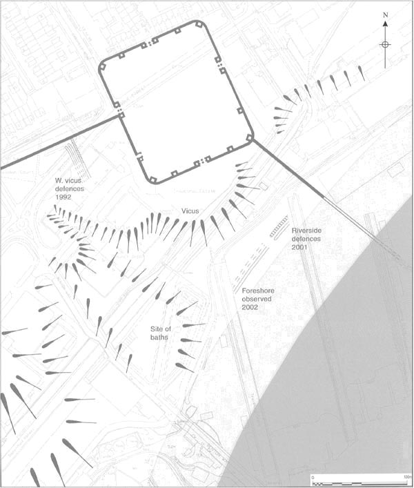
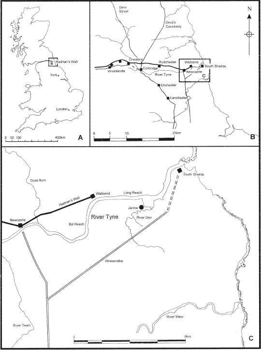
The Roman fort of Segedunum stood in a strong position at the eastern terminal of Hadrian’s Wall (Fig. 1.01), and indeed its Roman name is thought to mean ‘Strong Fort’ or ‘Victory Fort’ (Rivet and Smith 1981, 452–3). Its location on a spur overlooking a bend of the River Tyne provided commanding views in every direction, but particularly up and down the stretches of river to the east and south. The river was wider in antiquity (prior to the reclamation of land for shipyards as part of the Tyne Improvement works in the nineteenth century) and the ground dropped away fairly steeply from the south side of the fort down to the river bank (Fig. 1.02).
The fort was associated with the extension of Hadrian’s Wall four miles east from Newcastle c. AD 125 (Daniels 1989, 77). Enclosing an area of 4.1 acres, it was probably designed to hold an equitate quingenary cohort of about 600 soldiers, including c 120 cavalry. The primary layout of the internal barrack accommodation, with six infantry barracks and four cavalry ‘stable-barracks’, appears to confirm this (Hodgson 2003, 13). In the third and fourth centuries the Cohors IV Lingonum equitata was stationed there (Daniels 1978, 57 and Breeze and Dobson 2000, 256–7, 273; cf. RIB 1299–1301). Occupation probably continued right up until the end of the Roman period. The Notitia Dignitatum, compiled towards the end of the fourth century puts its commanding officer – the tribunus cohortis quartae Lingonum, Segeduno (ND Occ XL 33) – first on the list of the Wall’s regimental commanders headed Item per lineam valli, (‘Also, along the line of the Wall’ …). At some point in the second century the Cohors II Nerviorum, may have served as the garrison (RIB 1303), although it was not an equitate unit.
A civil settlement extended in the angle between the Wall and the Fort, stretching down to the riverbank (Fig. 1.02). A bath-house, temple or shrine, two burials, two or three roads and a potter’s kiln have so far been recorded. The eighteenth-century antiquary, Wallis, also noted the remains of a possible quay at the shore of the river (cf. Snape and Bidwell, 1994). The ultimate stretch of Hadrian’s Wall running from the south-east corner of the fort down to the river was partially uncovered in 1903, whilst recent excavation of the Wall along Buddle Street to the west of the fort has revealed post holes and a ditch system, thought to be part of the vicus defences (Snape 1992).
Today the site is located in the centre of urban Wallsend and is presently under the guardianship of North Tyneside Metropolitan Council.
Between 1975 and 1984 a detailed programme of archaeological investigation was carried out at Wallsend on the site of the Roman fort of Segedunum. The excavations covered virtually all areas of the fort with the exception of Buddle Street and an area destroyed by the cellars of the Simpsons Hotel.
The excavations were directed by Charles Daniels, with funding and support from the Department of the Environment, North Tyneside Council, the Manpower Services Commission, Newcastle University and the Society of Antiquaries of Newcastle upon Tyne.
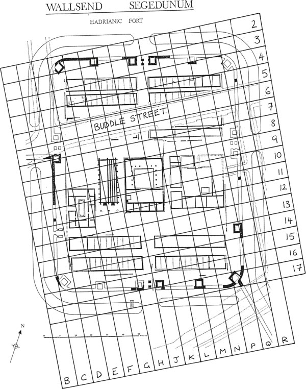
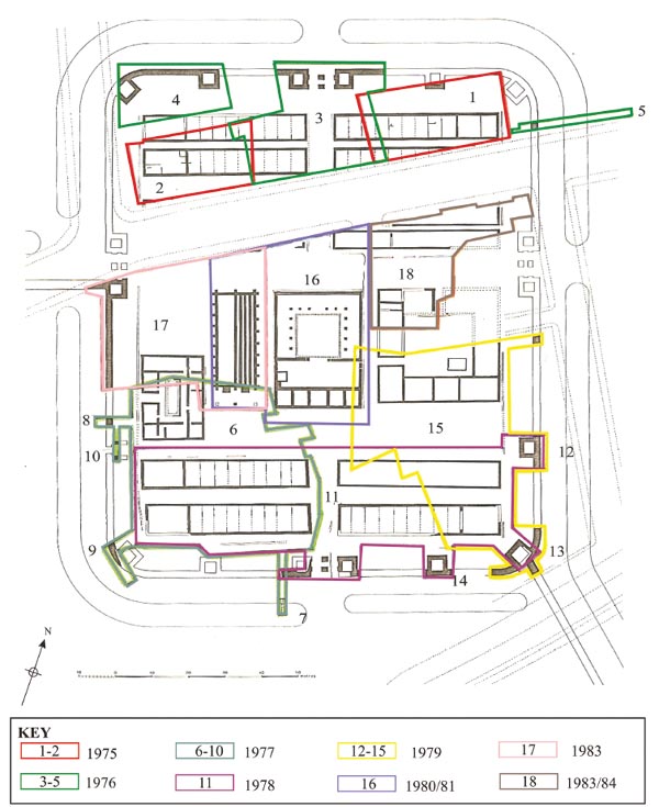
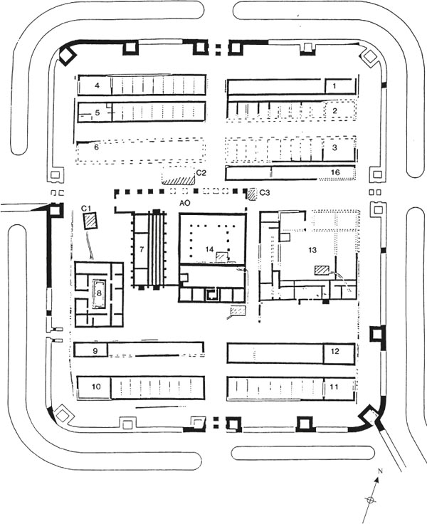
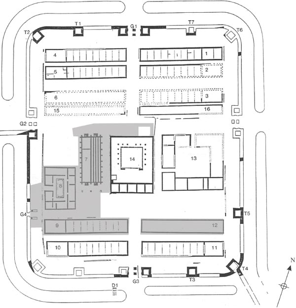
The whole fort was divided up into 10 × 10 metre grids, which were ordered alphabetically and numerically, running from B–R and 2–17 (Fig. 1.03). Each grid reference provided the recording and location of contexts and features across the fort. In total 18 sites were excavated in the ten years of work at Wallsend, each site covering a number of grids (Fig. 1.04; and see Table 1.01 for a listing of the grid squares in each site).
Excavation began in the fort’s praetentura (front third) between 1975 and 1976, with Sites 1–5 examining the barrack buildings (1–2, 4–5), along with part of the fort’s northern defences and road system. Between 1977 and 1979 excavations moved to the central range and the retentura (rear third) of the fort (Sites 6–15) examining the remaining barrack buildings and chalet ranges (Buildings 9–12), the southern parts of the hospital and the commanding officer’s house (praetorium), and elements of the fort’s southern and western defences and road system. During the final years (1980–4) excavation focussed on the central range of the fort, with the examination of the headquarters (principia) and granary plus their associated forehall, the remainder of the hospital and praetorium, the west gate together with adjoining stretches of the fort curtain and Hadrian’s Wall, and a workshop building (16) and barrack (3) to the northeast of the via principalis along with a further trench across the fort’s eastern defences and intervallum road.
Table 1.01 Concordance table listing the sites and grid squares excavated in each year
| Year | Site | Grids |
|---|---|---|
| 1975 | 1 | M4, M5, N4, N5, P4, P5, Q4, Q5 |
| 2 | E4, E5, F4, F5, G4, G5, H4, H5 | |
| 1976 | 3 | H4, H5, J4, J5, K2, K3, K4, K5, L2, L3, L4, M3, M4, M5 |
| 4 | E2, E3, F2, F3, G2, G3, H2, H3 | |
| 5 | Q5, R5 | |
| 1977 | 6 | F13, F14, D10, D11, D12, D13, D14, D15, E10, E11, E12, E13, E14, E15, F10, F11, F12, F13, F14, F15, G11, G12, G13, G14, G15, H11, H12, H13, H14, H15 |
| 7 | G15, G16, G17 | |
| 8 | C11, D11 | |
| 9 | B14, B15, C14, C15 | |
| 10 | C11, C12 | |
| 1978 | 11 | C13, C14, D12, D13, D14, D15, E12, E13, E14, E15, F12, F13, F14, F15, G13, G14, G15, G16, H13, H14, H15, H16, J13, J14, J15, J16, J17, K13, K14, K15, K16, L13, L14. L15, L16, M14, M15, M16, N14, N15, N16 |
| 12 | P13, P14, Q14 | |
| 13 | N16, N17, P16, P17 | |
| 14 | L16, L17, M16, M17 | |
| 1979 | 15 | J13, K10, K11, K12, K13, L10, L11, L12, L13, L14, M11, M12, M13, M14, M15, M16, N11, N12, N13, N14, N15, N16, N17, P11, P12, P13, P14, P16, P17, Q11 |
| 1980/81 | 16 | F8, F9, F10, F11, G7, G8, G9, G10, G11, H7, H8, H9, H10, H11, H12, J7, J8, J9, J10, J11, J12, K7, K8, K9, K10, K11, K12, L7, L8, L9, L10 |
| 1983 | 17 | C7, C8, C9, C10, D7, D8, D9, D10, E7, E8, E9, E10, F7, F8, F9, F10, F11, G7, G8, G9, G10, G11, H7, H8, H9, H10, H11 |
| 1983/84 | 18 | L7, L8, L9, L10, M7, M8, M9, M10, N7, N8, N9, N10, P7, P8, Q7, Q8 |
In general, the buildings were fully exposed wherever possible and their later surviving features and deposits were extensively explored and recorded, but the earliest levels, particularly in the barracks were often investigated by means of small sondages, to avoid removing the later structures.
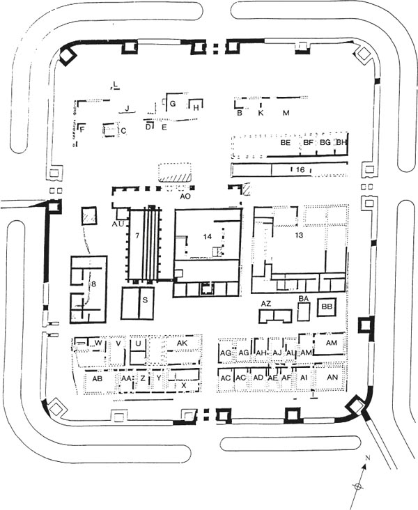
The building numbers and codes featured below (14, AZ etc.) are those adopted in the site and research archive documentation. The detailed breakdown of the separate stages of excavation is as follows:
1975 Sites 1 and 2 were excavated in the fort’s praetentura.
Site 1 covering an area of 670m² examined the northeast angle of the fort. Excavation revealed two barrack blocks, Building 2 with its associated ‘shacks’ and Building 1. Little of the southern barrack (2) was available for examination except a small strip across its north-western end. A segment of the north fort wall, angle tower and north interval tower, along with the intervallum road and the alley between the two buildings, was also investigated.
Site 2, covering an area of c.500m², examined an area in the north-west of the praetentura. Three buildings and the late overlying ‘shacks’ were examined, comprising the south-western half of Building 4, the western half of Building 5 and the north-west corner of Building 6. Part of the intervallum road was also uncovered. (Britannia 1976, 7, 306–8)
1976 Sites 3, 4 and 5 were excavated in the north and north-west of the praetentura.
Site 3 covered an area of 1100m² in the north central area of the praetentura. This included the area of the fort lying between the 1975 excavations which overlapped with the western area of site 1 and the eastern area of site 2. The north gate with two guard chambers and part of the via praetoria were examined along with the western half of Buildings 1 and 2 and the eastern half of Buildings 4 and 5.
Site 4 covered an area of 400m² in the north-west part of the praetentura. Part of the robbed north fort wall, interval tower, north-west angle tower, intervallum road and the north-west corner of Building 4 were examined. (Britannia 1977, 8, 371–2)
Site 5 investigated a narrow strip across the intervallum road to the east of Building 1 as well as a small segment of the north-east fortification wall and outer ditch.
1977 Sites 6–10 covered an area of 2000m² in the southwest angle of the retentura.
Site 6, the largest area, examined part of the via quintana, the southern half of the hospital (Building 8), Buildings S/T, AV and AX to the east of the hospital and began clearance of two complete barracks (9 and 10) plus the intervallum road to the south.
Site 7 sectioned the southern defences locating the ditch to the south of the fort.
Site 8 examined a segment of the western fort wall.
Site 9 investigated the south-west angle of the fort wall.
Site 10 examined the porta quintana sinistra. (Britannia 1978, 9, 419)
1978 Excavation was undertaken on Site 11, in the retentura.
This continued the investigation of Buildings 9, 10 (as begun in 1977, Site 6), extending the excavation area eastward to include Barracks 11 and 12 with their overlying chalet ranges.
In addition, various components of the south-eastern defences were investigated, including the interval tower between the east gate and south-east angle (Site 12), the south-east angle tower and Branch Wall leading down to the river (Site 13), and the interval tower between the south gate and south-east angle (Site 14), and a large part of the south gate (porta decumana).
Figure 1.04: Wallsend Fort. Plan of the yearly stages and constituent site numbers of the Daniels excavations.
1979 Excavation was undertaken in the eastern areas of the retentura and central range.
Site 15 covered a large area in the south-eastern quarter of the fort, including the southern half of the praetorium (Building 13), the eastern part of the via quintana with Buildings AZ, BA and BB overlying it. The eastern half of Buildings 11 and 12 in the retentura were investigated continuing the 1978 excavations.
Investigation of towers on the southern and eastern defences continued (Sites 12–14), in particular the south-east angle tower and Branch Wall and a section across the east defences a little way south of the east gate (in Q11).
(Britannia 1980, 11, 355–8)
1980/1 Site 16 was excavated in the fort’s central range (latera praetorii).
The headquarters (Building 14) and the granary (Building 7) including the via principalis and forehall (Building AO) were examined up to the edge of Buddle Street. To the north of the via principalis two other buildings (Workshops 15 and 16) were partially excavated (Britannia 1981, 12, 322).
1982/3 Excavation of Site 17 began in the fort’s central range.
An area extending from the granary (exposed 1980/81, Site 16) and the west gate of the fort was examined. The north-west corner and north wall of the hospital were examined in continuation of the excavation of Site 6 (1977). The south guard chamber of the west gate, part of the fortification wall and foundations of Hadrian’s Wall were also located. Additionally, the intervallum road and via principalis to the north of the hospital were examined, revealing more of Building 15 (previously investigated in 1981). Features associated with the eighteenth- and nineteenth-century collieries were also revealed in this area. (Britannia 1983, 14, 289–90 and 1984, 15, 277–9)
1983/4 Site 18 in the central range previously covered by Simpsons Hotel was excavated.
The north-west corner and part of the via principalis frontage of the praetorium was examined (the southern end having been excavated in 1979). North of the via principalis (which itself was also investigated) Building 16, a workshop (previously examined in 1980/1), was almost totally excavated. Building 3, a barrack block, was only partially examined. (Britannia 1985, 16, 268–70).
A preliminary interpretation of the phasing of the fort was presented in 1989 by Charles Daniels (1989, 77–83), which essentially followed the Wall Period model, with four main phases of activity defined – Hadrianic, Severan, Tetrarchic, and late fourth-century (Figs 1.05–1.08). Post-excavation proper followed on immediately after completion of the final season of excavation (1984), with Peter Moffat being employed as a research assistant whilst Ian Caruana was also involved in the writing-up, having played a key supervisorial role in much of the excavation. A set of indices for the Level 3 archive was produced by 1989. A draft text for part of the structural discussion was then completed along with preparatory analysis of the coarse ware, and most of the other specialist reports were commissioned. A number of these latter were completed (e.g. the quernstones and vessel glass) or at least full catalogues produced (coins, small finds), however none of these were published and most still lacked accompanying illustrations. A publication synopsis was devised and the plans were drawn up for final publication.
The sum total of all this initial analytical work was a substantial research archive for the project, comprising:
• Draft text or outline notes for the majority of the structural discussion.
• Level 3 archive indices.
• Specialist reports (some, not all).
• Small finds and specialist reports illustrations (a few only).
• Inked plans (majority of those required for the final report).
However, following the end of Peter Moffat’s research assistant contract, progress largely came to a halt until 1997, when an opportunity to revive the postexcavation work was presented by the Segedunum Project.
The Segedunum Project, which commenced in 1997 and ran until 2000, involved the partial re-excavation and display of the Roman fort, the building of a new museum immediately adjacent and reconstruction of the fort bathhouse. As part of this scheme a sum was made available to publish the results of the earlier Daniels excavations with English Heritage contributing an additional sum.
It was decided by English Heritage that the structural report should be written up by the Archaeological Practice, University of Newcastle upon Tyne, with Alan Rushworth acting as project manager and principal researcher, and the finds report should be produced by Tyne and Wear Museums, with Alex Croom as principal researcher, coordinator and editor for the material assemblages. In furtherance of this an Assessment and Project Design was produced by the Newcastle University Archaeological Practice, with the assistance of Tyne and Wear Museums, in 1997 (NUAP/TWM 1997), setting out in detail what further work was required to bring the final report to publication and ensure the significant potential of the 1975–84 excavation data was fully realised. This contained a full quantitative and qualitative summary of the site and research archives, together with a statement appraising the archaeological potential of the data contained therein, formulated according to the principles set out by MAP2 (English Heritage 1991). On receiving approval, work by the NUAP and TWM teams commenced, following the methods and programme set out in the Project Design.
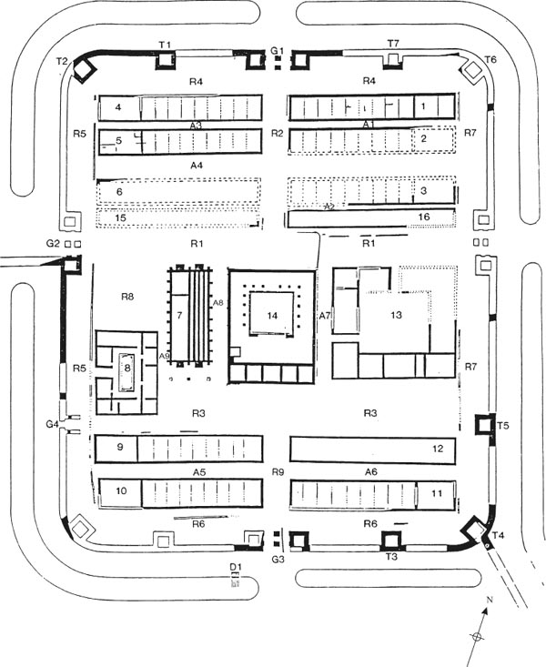
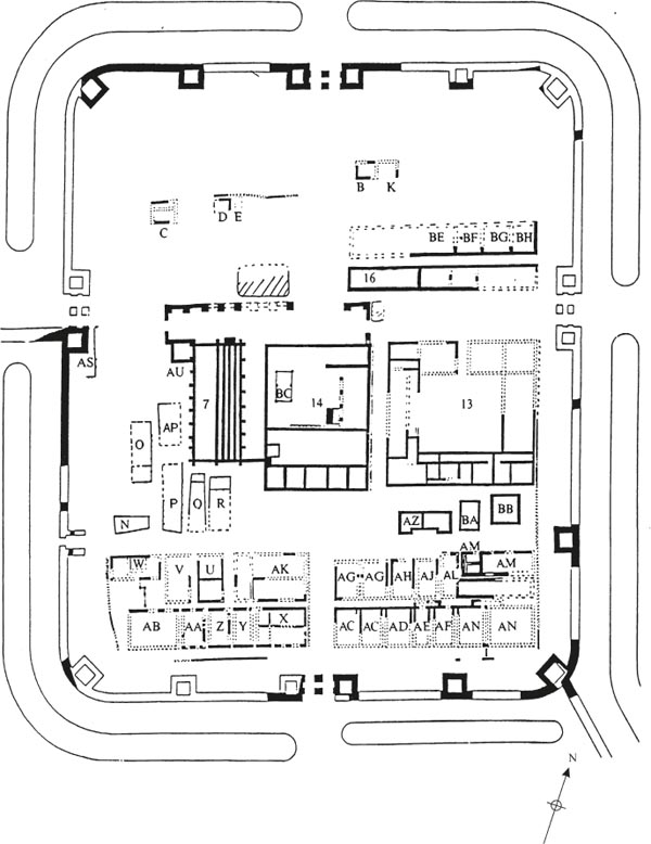
A profound reassessment of the 1975–84 results was sparked by the new information provided by the Segedunum Project excavations conducted by Tyne and Wear Museums. Although not on the same scale as Daniels programme, the 1997–8 excavations were still extensive and, in large measure, complemented Daniels work by providing a clearer understanding of the primary, Hadrianic levels, which had not been fully exposed in 1975–84. The Project involved, inter alia, the re-excavation and display of the hospital, granary, forehall and Buildings 9 and 12 with their overlying chalets (Fig 1.09). The excavation results, published by Tyne and Wear Museums (Hodgson 2003), had implications far beyond these areas, however, affecting our understanding of the phasing of the fort as a whole.
Several important results of the 1997–8 excavations are listed below. This is not an exhaustive list of the conclusions of the 1997–8 programme. Rather it represents those conclusions which had major implications for the writing-up of the Daniels excavations, in terms of changing the wider understanding of the fort’s development:
1 The barrack blocks were built of timber during the forts primary phase.
2 A timber building also occupied the site of the stone hospital in this phase and, although built to a different plan, may represent the primary hospital.
3 The four barracks in the retentura, formed what are now termed stable-barracks, designed to accommodate both the men and horses of a cavalry turma within the same block.
4 Work on the ditches outside the fort in 1991 and 1997 has clarified the changing patterns of access into the fort and provided clues to the history of the gates.
5 Most of the fourth-century structures and deposits had been destroyed by much later agricultural and industrial activity. Accordingly many of the structures assigned to the fourth century by Daniels should belong to an earlier period. The four chalet ranges in the retentura and the post-hole buildings over the hospital and south of the granary are considered to have been erected c. 225–35 or slightly later, but certainly by the mid-third century. The hospital would have been demolished at this stage.
The consequences of those findings in interpreting the results of the Daniels excavations are apparent in the next chapter and, in much greater detail in the chapters relating to the individual fort buildings and building groups.
The overriding significance of the 1975–84 excavations was not lessened by the 1997–8 programme. The site of Segedunum, in Wallsend, at the eastern end of Hadrian’s Wall, has the distinction of being amongst the most extensively revealed of Roman forts. Only one site in Britain has been more completely explored with modern excavation techniques, the Flavian fort at Elginhaugh, but this was only occupied for short and chronologically tightly defined period, whereas Wallsend presents the opposite case of a site with multiple structural phases of occupation. Whilst other comparable sites may eventually attain a similar or greater level of excavation and understanding, notably Arbeia-South Shields and Vindolanda, none as yet matches Segedunum in the sheer extent of excavation and range of fort buildings fully investigated.
This statement needs qualifying, however. Most of the late Roman levels had been destroyed by post-Roman activity. Moreover the earliest levels (Period 1 – Hadrianic) were not fully investigated by Charles Daniels as the 1997–8 programme of excavation has made clear. For the most part, the remains revealed by Charles Daniels’ work fell within the period extending from the mid-Antonine rebuilding of c 160 up to the late third century, but not exclusively so. Sufficient early features can be identified to give an impression of the primary layout of the fort, particularly when interpreted in the light of the results of the 1997–8 excavation campaign. Some late Roman features also survived the devastation wrought by medieval ploughing and colliery era intrusions, in little pockets here and there. Although nowhere near sufficient to establish a coherent overall plan of the fort in the later period they do provide clues as to the character of fourth-century occupation.
It should also be noted that even with an excavation programme as extensive as that undertaken in 1975–84 not all the fort could be examined. One area which was never available for excavation was the course of Buddle Street, which runs from the north side of the west gate towards the north-east corner of the site. The second area partially excluded from Daniels excavations was the fort defences, which were only investigated by selected trenches extending into the area of the defences to reveal specific structures, such as interval and angle towers or gates, or to record a section across the rampart, curtain and, at one point on the south side, the lip of the ditch. The only extensive excavations of the defences were the area of the western defences extending south of the west gate investigated in 1983 and substantial stretches of the north defences uncovered in the first two seasons. However the boundaries of the 1975–6 excavation sites, which were often determined by still functioning streets and lanes associated with the surrounding housing terraces, meant that even here the ramparts were not entirely exposed. Even so, when combined with the 1997–8 excavations which fully explored the rampart area on either side of the minor west gate, some idea of changing nature of the defences can be gained.
The site was excavated under what was essentially a rescue programme, the entire area of the fort being scheduled for redevelopment following the demolition of the existing terraced housing. Recording was therefore not as complete as more recent programmes at South Shields or Birdoswald. Context descriptions are often very summary and the record of stratigraphic relationships somewhat haphazard and occasionally contradictory. As a consequence, interpreting the results, as documented in the archive, involves grappling with many uncertainties. Nevertheless these problems should not be overstated. The site was among the first on Hadrian’s Wall to be excavated according to the principles of modern open area excavation, as opposed to the small box trenches still in use at sites like Corbridge and Haltonchesters in the 1960s. Cases where an identifiable feature or deposit was not allocated a context number or where two features were given the same number were very rare and the vast majority of contexts can be pinpointed on an accurately drawn site plan or at least a sketch plan overlay. It must also be admitted that the state of preservation of the various buildings uncovered at Wallsend generally leaves much to be desired. Practically every type of structure can be paralleled by better-preserved and hence individually more informative examples elsewhere.
Nevertheless, even with all the above caveats, the evidence generated by the Daniels excavations at Wallsend has, uniquely, provided an opportunity to analyse in detail the changing layout and pattern of occupation across an entire fort, particularly in the first two centuries of its occupation. Building activity in the forts of Hadrian’s Wall was traditionally presented as a series of discrete periods of widespread activity. Whilst it is certainly still true that there were times when the northern frontier was a focus of more intense imperial concern and patronage, the ‘Wall Period’ model is no longer rigidly adhered to today. A brief glance at the corpus of building inscriptions from northern frontier forts, for example, is sufficient to demonstrate that the physical infrastructure of these military bases was being renewed throughout the period from the late second right up to the mid-third century, with new buildings being erected and old ones refurbished. The data from Wallsend provides the opportunity to chart this process right across one site in the second and third centuries. In the absence of numerous inscriptions and with never as many securely-stratified coins as one would like, the predominantly pottery-based dating evidence available from a fort like Wallsend means there is a limit to the chronological precision which can be achieved. However, detailed analysis of the relationships between the various buildings, provides a relative chronology which helps to narrow the chronological parameters of the fort’s structural phases or periods.
Figure 1.09: Areas of the fort re-excavated in 1997–8 (taken from Hodgson 2003, fig. 6, with kind permission).
That such an exercise is possible at all is a testament to the inspiration and sheer, indomitable energy of Charles Daniels in sustaining so large and complex an excavation project over a period of ten years and ensuring its continuance under differing management frameworks. It is to be hoped that this report represents a fitting tribute to his life and work.