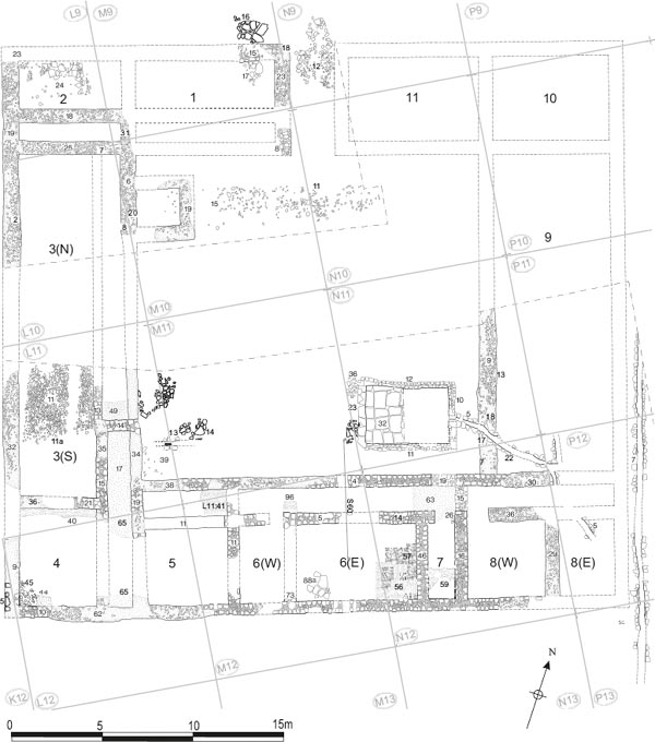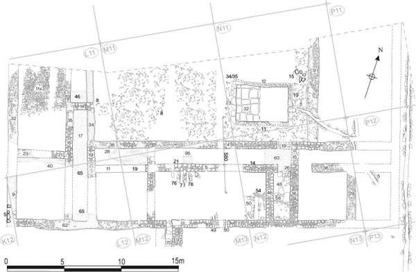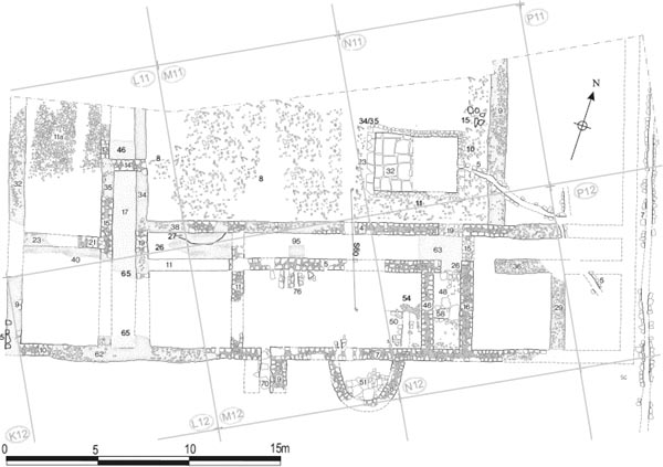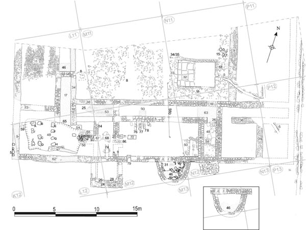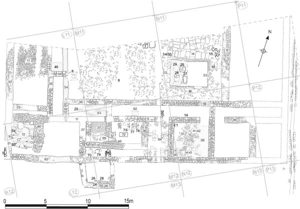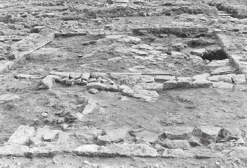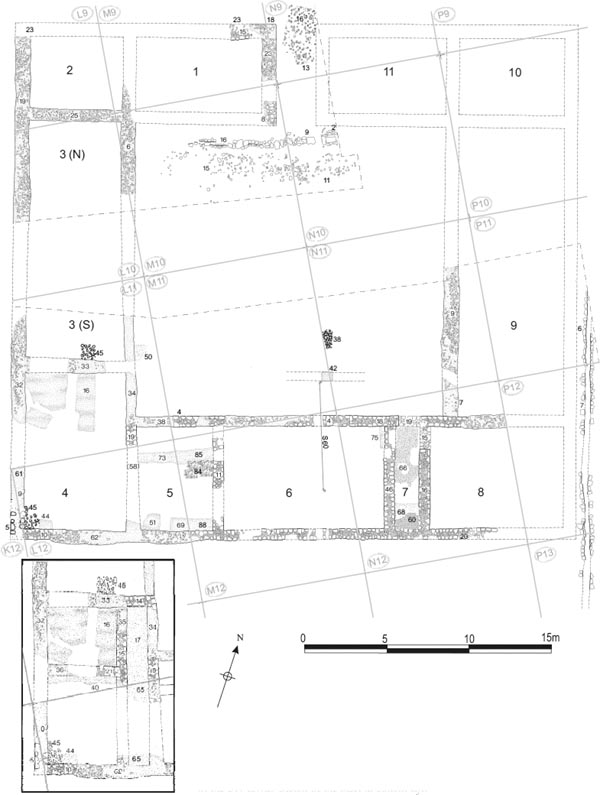
Figure 9.01: Building 13, Phase 1 at 1:200, with a possible alternative primary layout in the SW corner shown in the inset at bottom left.
Grid squares: L9, L10, L11, L12, M9, M10, M11, M12, N9, N10, N11, N12, P11, P12
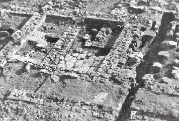
At the eastern end of the central range, next to the principia (14), was situated the largest single structure in the fort, which Daniels labelled Building 13. This took the form of a large courtyard building measuring 34.8m by 31.6m, and was immediately recognised as the commanding officer’s house (praetorium) on the basis of its size and form. Daniels investigated the structure over the course of two separate seasons, several years apart. Excavation in 1979 concentrated on the southern half of the building and a series of adjacent structures on the north side of the via quintana. The north-west corner, including the main entrance, was uncovered during the final season of excavation in 1983–4. A substantial part of the building remained uninvestigated, including the north-east corner and much of the east wing and courtyard, areas which had largely been destroyed by the cellars of Simpson’s Hotel. Indeed the two areas which were excavated were not actually linked up, with a 5.0–6.0m wide strip of the west range remaining unexplored. The survival of the remains varied markedly across the building. Effectively all that remained in the north-west corner were rubble foundations, which marked the line of the building’s walls, and occasional fragments of primary flooring, but parts of the southern range displayed much better preservation with complex structural sequences evident, reflecting repeated alterations to hypocaust heating systems for example.
Initial post-excavation analysis was summarised in a series of inked phase plans and a draft text providing a grid-by-grid outline of the building’s structural phasing (covering the 1979 excavation area only). The latter was divided into five main phases with Phases 3 and 4 consisting of two and three sub-phases respectively. The summary text included a number of variant interpretations, attempting to resolve problems and inconsistencies which were apparent in the structural sequence initially presented. This scheme was subsequently reworked by Peter Moffat, resulting in a revised structural outline comprising four main phases, with Phase 3 being divided into six separate sub-phases. The new phasing was embodied in the database listing of Building 13 contexts and represented most clearly in a second set of inked phase plans, but no actual descriptive text was prepared before the initial post-excavation programme came to an end in 1989. It is evident, however, that it represents a far more coherent and satisfactory scheme which resolved many of the problems inherent in the initial scheme and essentially is that followed here.
In terms of the overall periodisation of the fort, Phases 1 and 2 of the building were considered to fall within Daniels’ Fort Phase 1, which spanned the second century, with Phase 1 representing the initial Hadrianic structure whilst the Phase 2 modifications may be assigned to the Antonine period. Building Phase 3, with its six sub-phases, was thought to correspond with Fort Phase 2, beginning in the Severan era, c. 200, and encompassing most of the third century, whilst Phase 4 was believed to equate to Fort Phase 3, beginning during the Tetrarchy at the end of that century. However, the composition of the dateable material recovered from the building, and in particular the extreme paucity of late third- and fourth-century pottery, even in Phase 4 contexts, would imply that Moffat’s four phases probably did not extend as late as he presumed. This need not mean that the praetorium was abandoned by the late third century, merely that here, as elsewhere, the later Roman levels had been destroyed by medieval and later ploughing and colliery era activity. Thus, in terms of the periodisation adopted by the 1997–8 excavators, and with the exception of one or two isolated, possibly late features, Phases 1–4 of Building 13 may be judged to roughly correspond with Periods 1–4.
The rooms of the primary building are numbered in anti-clockwise direction proceeding from Room 1, on the west side of the main entrance, round to Room 9 in the southern half of the east range.
In its primary phase the commanding officer’s house was composed of a series of rooms arranged around an almost square courtyard and probably opening directly on to it. Corridors between the rooms and the courtyard were not considered by the excavators to be a feature of the house in this initial phase.
The dimensions of the courtyard were 17.70m northsouth and 18.50m east-west. The main entrance was positioned in the centre of the north side of the building, opening onto the via principalis. The entrance passage was 6.10m long (the established width of the north range). Its width was restored by the excavators as 2.40m, although no trace of the east wall was found in the expected position, only what appeared to be a gravel surface (N10:13) comparable with primary level in the courtyard (M10:15, N10:11), so it is possible that the entrance was somewhat wider than anticipated and not perfectly centred along the north face of the building. The metalled surface only survived on the east side of the passageway. At the north end of the entrance it comprised a light yellow gravel (N09:13), associated with very fine, bright yellow-orange sand (N09:16), Further south it was recorded as a layer of orange and red gravel, including pebbles and cobbles, 0.10–0.30m in diameter, smoothed by wear (N10:13). Elsewhere only a very light yellow clay layer (N09:17) was present, perhaps a levelling deposit for the construction of the fort. The clay was cut by the foundations for the west wall of the entrance (M09:23, N09:18) and was probably overlain by the gravel surface (N09:13/16), although this was not explicitly stated.
The primary surface in the courtyard was variously described as being composed of ‘loose rubble in dark brown silt’ (M10:15), and light red and grey gravel incorporating smooth, worn stones, 0.30m in diameter, associated with traces of burning and fine black grey silt (N10:11). The site plan (P417) indicates the surface was predominantly brownorange in colour with sandy patches. Despite any apparent dissimilarity in the above descriptions, the site plans clearly indicate that the two were regarded as equivalent contexts, belonging to the same layer of metalling. A patch of very light yellow silt (M10:13), c. 1.50m in diameter, was also associated with this primary courtyard level. Running parallel with, and around 1m to the south of the northern edge of the courtyard was a stone-lined drain (M10:16, N10:09). The drain was traced for some 9m, as far as the eastern edge of the 1983–4 excavation area, and probably originally extended the full distance from one side of the courtyard to the other. Although it cut the primary courtyard surface the drain was assigned to Phase 1 by the excavators. Presumably the top of its side walls appeared flush with the courtyard surface implying they were broadly contemporary. A distinct black strip (M10:14), 0.30–0.55m wide, which extended southward from the east-west drain, was interpreted as the robbed-out remains of a second drain. This was in line with the west wall of the entrance passage and could not have extended further northward. Its phasing was uncertain. There was no indication that it interrupted the course of the east-west drain, but it did cut the primary courtyard surface (M10:15, M10:13) and was overlain by later courtyard levels (M10:02, 04), so its construction might belong to this phase.
In the southern part of the courtyard the earlier levels were only investigated by means of small sondages or by examining areas such as the southwest corner, where the upper levels had not survived so completely. This inevitably resulted in an imperfect understanding of the development of the courtyard. It is not clear that the sondages were all taken down to the same level which makes the interpretation of the results more problematic. Nevertheless a reasonable sequence can be proposed.
On the west side of the courtyard the lowest level was a grey sandy silt loam (L11:50) observed in a small pocket next to the courtyard wall (L11:34). This was overlain by a layer of mixed grey silt containing charcoal and small fragments of grey-white mortar (L11:47). Two small sondages were also excavated beside the west wall of the large cistern, which was constructed in the south-east corner of the courtyard in Phase 2 or 3. The fullest sequence was revealed next to the north-west corner of the cistern. Here the lowest level recorded was layer of large angular sandstone rubble (N11:39). The excavators noted that this did not really look like a surface, being less flat and even than later stone layers, and it was interpreted as a makeup layer instead. It was said to overlie the original ground surface, although the latter was not actually described or assigned a context number and it is uncertain to what if any degree that underlying level was ever properly exposed. The rubble was overlain by a layer of smallish sandstone cobbles (N11:38), averaging 0.10m in diameter, set in a very sandy matrix. The surface of the cobbles was slightly worn and was covered by grey sandy silt.
Figure 9.01: Building 13, Phase 1 at 1:200, with a possible alternative primary layout in the SW corner shown in the inset at bottom left.
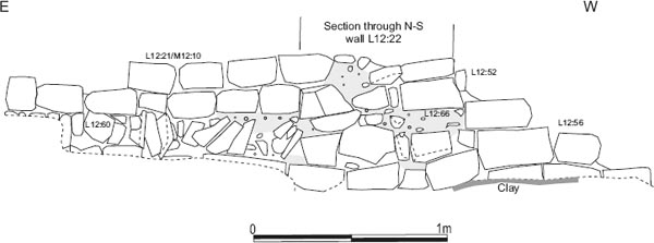
Figure 9.02: N-S section across the south range in M11 and M12, recorded along the east side of modern drain cut M11:02/M12:02. Scale 1:30.
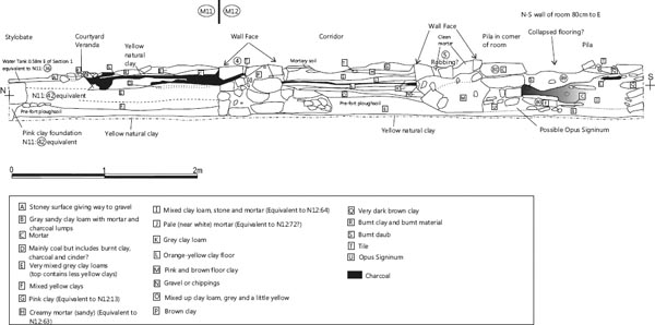
Some 1.50m further south, near to the south-west corner of the cistern, a second sondage revealed a 0.55m wide strip of angular rubble and pink clay (N11:42). This apparently ran on an east-west alignment and was interpreted as the foundation of a stylobate which would have supported a colonnaded portico. It was overlain by dirty grey clay-loam (N11:41). The context records, site plans and sketch plans do not record any surviving remains of the stylobate itself, which was presumably largely removed during later remodelling, but a large, apparently squared, stone block, 0.22m high and in excess of 0.27m wide, is shown in the corresponding position, overlying the foundation deposit at the northern edge of section S60 (see Fig 9.02). A line of small stones extending southward from the base of the large block, and overlying the layer identified as pre-fort ploughsoil (‘OGS’ – original ground surface), might represent the surface portico walkway. No trace of an equivalent stylobate or colonnade was identified on the other sides of the courtyard.
In the north-west quarter of the building for the most part only the rubble foundations of walls were preserved and these generally ranged between 0.85m and 1.00m in width for the main external walls, although internal partition walls such as that between Rooms 2 and 3 (L09:25, L10:07) were as little as 0.70m wide in places. As regards actual standing masonry, only one short stretch of the inner face of the north wall (M09:15) survived, comprising no more than four stones. Initial observation suggested these facing stones were slightly out of line with the foundations of the north wall, raising the possibility that they might reflect the rebuilding of this wall. However, given the very fragmentary condition of the north wall’s surviving remains, it is by no means clear that the short stretch of facing was actually out of line.
There was evidence for one room (1) on the west side of the entrance and another in the north-west corner (2). Room 1 measured internally c. 7.60m from east to west by 4.50m, north-south. Most of its area had been removed by one of the cellars in Simpson’s Hotel and other modern intrusions, leaving only the northeast corner and stretches of its east wall foundations. The internal dimensions of Room 2, which occupied the north-west angle of the building, were 5.60m by 4.30–4.40m. Excavation in the room’s interior revealed a mid-grey clay-silt (L09:26) which was interpreted as the pre-construction ground surface with some surviving floor deposits.
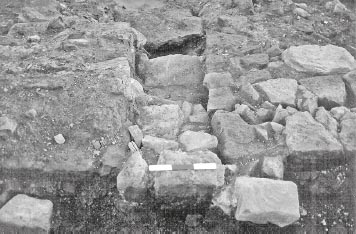
The west wall of the building was preserved only in the form of its orange clay and angular rubble foundations (L09:19, L10:02, L11:32, L12:61) with the exception of a 2.70m length of masonry (K12:05, L12:09) at the wall’s southern end, which had escaped robbing. This stretch of masonry was 0.55–0.65m wide and was constructed of fine-grained sandstone facing blocks, olive-yellow in colour, like the masonry of the adjoining length of the south wall (L12:10). Some rubble core survived in places, although the mortar bonding material had entirely decayed. There were, however, certain indications, noted in the context records, that it had been rebuilt during Phase 3 (perhaps 3vi). The wall’s foundations were 0.80–1.05m wide. The east wall of the range was marked by similarly poor preservation. This continued the line of the partition wall (M09:31) between Rooms 1 and 2 southward, forming the courtyard frontage of Rooms 3 and 4 (M10:20, L10:08, L11:34), with only the clay and rubble foundations surviving again.
As restored by the excavators, Room 3 occupied almost all of that part of the west range which lay on the west side of the courtyard. Its south wall was represented by the line of its foundations consisting of orange-pink clay and rubble packed in a 0.65–1.00m wide trench (L11:33). A 1.25m surviving length of masonry wall (L11:14) over this foundation was evidently considered by the excavators to represent a Phase 2 rebuild. The reasoning behind this was not made explicit in the excavation archive. However, it could be related to the recorded differences in the stone and mortar used in the masonry. Coarse grained sandstone blocks, with a very orange colouration derived from the mortar bonding, were used in L11:14, whereas the primary east and west walls of the range were composed of fine-grained sandstone, olive yellow or yellow-green in colour with mortar which was off-white when dry and yellowish when wet. On the other hand the masonry composition of other walls supposedly belonging to Phase 2 (e.g. L11:15, 21) was similar to that of the primary walls so it is not altogether clear how useful this distinction might be.
On the basis of the layout suggested above, the room’s external dimensions were 7.50m by 16.00m. Internally it was 5.55m wide at its north end and 6.00m wide at its south end, and would have been 14.20–14.40m in length from north to south. It is, however, quite feasible that another partition wall, dividing this part of the range into two separate rooms, could have been remained undiscovered in 5.00–6.00m wide central strip which was not investigated in 1979 or 1983–4. Excavation at the northern end of the room exposed a layer described as dark grey-brown soil (L10:03), interpreted as the pre-construction ground surface with some surviving floor deposits, like that found in Room 2. At the southern end of the room a surface of largish sandstone cobbles and flags (L11:45), up to 0.30m across, was exposed in one small pocket next to the south wall (L11:33).
Figure 9.03: Section S58 on the west side of colliery era posthole (M12:30) in the south corridor, at 1:10.
With internal dimensions of 9.50m from north to south and 6.10m wide from east to west, Room 4 occupied the entire south-west corner of the building and also extended sufficiently far along the west range to face directly onto the southern end of the courtyard. The main doorway, providing access to the room, was presumably located here, although no remains of a threshold survived. It was separated from Room 5 to east by a 0.65m wide partition wall (L11:19, L12:58), which formed a continuation of the east wall of the range. As was typical of the building’s primary walls, this was constructed of fine-grained sandstone facing stones, keyed into a rubble core bonded with gritty, off-white mortar and set on foundations of orangepink clay and sandstone rubble (L11:34, L12:62). In the interior, a surface of brown-grey, silty clay loam with flecks of stone and charcoal (L11:16) was present across the northern part of room. In a small pocket next to the south wall, a yellow sandy clay floor (L12:44) was exposed, over a makeup layer of small sandstone pieces, up to 0.12m across, including small fragments of micaceous slabs and a little off-white mortar in a dark grey soil matrix (L12:45).
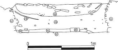
The structures of the south range were the bestpreserved in the building, with a higher proportion of the walling here having escaped robbing. Substantial lengths of masonry belonging to the north and south walls of the range survived along with corresponding masonry associated with the internal partition walls separating its constituent rooms. These walls were constructed of medium-sized, fine-grained sandstone facing stones, which were keyed into a rubble core bonded with gritty, off-white mortar and set on foundations of orange-pink clay and sandstone rubble. The north wall (M11:04, M12:04, N12:18; foundations: L11:38), forming the courtyard frontage, was 0.60–0.68m wide. Its line was continued eastward by the partition wall separating the south-east corner room (8) from Room 9 in the east range only marked by rubble foundations (N12:30) at this point. The recorded width of the south wall (L12:10, M12:07, N12:17, 20; foundation L12:62) ranged between 0.63m and 0.68m. The external width of the range was 7.40m and the internal width generally around 6.15m.
Figure 9.04: West facing section (S62) of a sondage through the floor levels in the south corridor in M12, at 1:20.
Figure 9.05: Section S59 through unexcavated layers of Room 6 seen in the east side of later intrusion N12:28, at 1:10.
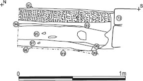
Next to the large south-west corner chamber (4), was a smaller room (Room 5), measuring internally 4.60m from east to west by 6.25m from north to south. The wall (M11:10, M12:11) which separated it from Room 6 to the east was 0.68m wide and was bonded to both the north and south walls of the range in the normal fashion. Like the other rooms of the primary phase this occupied the full width of its respective range. Again little evidence remained regarding the room’s initial function. A yellow sandy clay floor, with some overlying grey silt, was noted in pockets in the centre of the room (L12:73, M12:85), where it was observed at the bottom of a later robber trench (L12:11, M12:19), and alongside the south wall (L12:51, 69, M12:88). This was similar to the floor surface noted in the southern part of Room 4 (L12:44) and covered an orange-yellow gravel makeup deposit (L12:71, M12:84), composed of stones up to 0.05m across, which in turn directly overlaid a grey clay loam (L12:72) interpreted as the pre-fort ground surface. In the north-east corner of the room, advantage was taken of the deep cut made by a colliery era post hole (M12:30) to record a section through the Roman levels on the west side of the pit (site drawing S58 – Fig 9.03 here). The pre-fort ground surface showed signs of clearance burning and also appeared to feature one and perhaps two narrow furrows, 0.12m wide at the top (0.05m at the bottom) and 0.09m apart. This was overlain and levelled by a layer of yellow-orange gravel clay and silt evidently equivalent to M12:84–85.
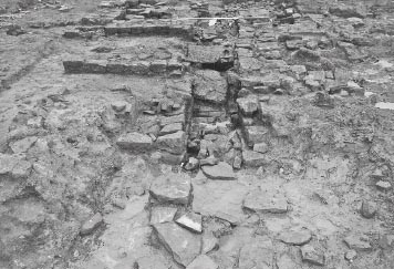
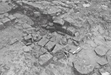
Located in the centre of the south range, the largest room on this side of the building, Room 6, had internal dimensions of 9.70m by 6.15m. Its west wall was formed by M11:10/M12:11, whilst its eastern limit was represented by a similarly constructed wall (N12:46), 0.65m wide, which also extended the full width of the range and was likewise bonded to the north and south walls. There was evidence for an entrance into the room at the northern end of this wall where several, apparently primary, levels present in the narrow passage to the east (N12:66, 70–71) extended across the remains of the wall’s footings (see below – Room 7).
Two small sondages through the full sequence of floor levels in the northern part of the room revealed the composition of the room’s earliest surfaces. One 0.70m square trial trench was excavated roughly midway along the length of the room, towards its north edge, in the area of the Phase 2 corridor (see section S62 – Fig 9.04 here). The lowest level revealed here was a mixed yellow sand-clay floor (M12:99). This was overlain by a thin mortar level (M12:98) – thickest at its southern end where it reached 25mm, decreasing to as little as 10mm elsewhere – which perhaps represented another floor surface. A further deposit, up to c. 55mm deep, composed of dark grey silt and charcoal in equal measure (M12:97) covered the floor levels and might represent occupation debris. In the north-east corner of the room, a series of floor levels and occupation deposits were uncovered up against the east wall (N12:46). The lowest floor was composed of a mixture of stone and sandy clay (N12:75), which was overlaid by dark grey silty clay loam flecked with charcoal (N12:74), probably representing occupation silt/ debris. This in turn was covered by a hard mortar floor surface (N12:72), pinkish-white in colour, changing to buff/white lower down where its composition was more mixed and included some stone. This surface was level with the top of the lowest course of the east wall and was overlain by a thin layer of charcoal and silt occupation debris (N12:73).
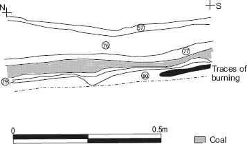
Further south, advantage was taken of a later intrusion (N12:28) in the eastern part of the room to record the full sequence of early layers (the westfacing section recorded as S59 – Fig 9.05 here). The pre-fort ground surface (N12:80) was drawn but not described, though it evidently displayed patches of burning, presumably reflecting clearance of vegetation. Directly overlying this was a thin layer of yellow/ grey clay loam (N12:79), tentatively interpreted as a floor, then a ‘coaly layer’ (N12:78), 20–60mm thick, presumably associated with early activity in the room. Above the coaly material was a mixed yellow-pink clay (N12:77), again perhaps a floor, overlain in turn by a 60–130mm thick level of grey clay loam (N12:76), and finally a spread of orange gravel (N12:57), which was interpreted as a surface or, perhaps more plausibly, a makeup level like that uncovered in Room 5. At only 20mm, this orange gravel was a relatively thin deposit, like the two possible clay floors (N12:79, N12:77 – 10–20mm and 20–30mm respectively). It was the first layer in the sequence to be exposed over a significant area, extending for 1.50m right up to the east wall, where its width was in excess of 2.20m. The gravel was overlain to the south by a surface of pink clay (N12:56), c. 20mm thick, which extended into the south-east corner of the room where site plan P203 suggests it was associated with small patches of mortar. As with the underlying gravel layer the western extent of this surface could not be gauged as it was cut by later features. A spread of charcoal and coal intermixed with a little grey silt (N12:54), which was present in patches over both the gravel and clay might represent an occupation deposit. The gravel (?) makeup, pink clay floor and charcoal/coal debris were associated with Phase 1 by the excavators, however the apparent existence of two possible underlying clay surfaces revealed by the N12:27 section might suggest that N12:54, 56 and 57 should be allocated to the subsequent phase, instead.
Separating Room 6 from Room 8, in the south-east corner of the building, was a narrow space, no more than 1.45m wide which ran the full width of the range. A doorway (N12:19) through the north wall (N12:18) provided access to this room from the courtyard. No equivalent jamb existed on the east side, but the position of the west wall (N12:16) showed the doorway could have been up to 1.30m wide, though it is perhaps more likely to have been slightly narrower. The west wall was 0.65m wide and of standard construction with fine-grained sandstone facing stones keyed into a mortar-bonded rubble core. It is possible that the room functioned as a passage with an equivalent entrance at the southern end of the corridor, which would have provided access to the praetorium from south side, or rear, of the building. There was no clear trace of a threshold at the relevant point in the south wall (N12:17), with only a single course remaining at the relevant point, but the other doorways into this room were represented by single courses of ordinary walling, flanked by squared off jambs, rather than obvious threshold slabs. Two courses survived to the west, which would be consistent with such an interpretation, but the second course came to a ragged end rather than a distinct jamb. Even if this room did function as a passageway at certain stages it cannot have done so for the entirety of its life. During the later stages of Phase 3 (Perhaps Sub-Phase 3iv) a rectangular stone platform (N12:45) was set against the external face of the south wall at the end of the passageway, which would have blocked access. It remains the most plausible interpretation of the room’s function, however. Suggestions in the context records that the room might represent a firing area for hypocausts in one or both of the neighbouring rooms are unconvincing as there was no evidence for flues through either side wall.
A doorway (N12:15) into Room 8 was apparent at north end of the east wall (N12:16). This was perhaps 1.35m wide and comprised a single course of the wall constructed in the typical manner – that is to say it was not furnished with slabs spanning the full width of the threshold – but its position was clearly indicated by a straight jamb at the south side of the doorway, where two courses of the wall survived. As noted above, there was probably a corresponding doorway at the north end of the west wall (N12:46), providing access to Room 6 on that side of the corridor. The wall footings did not survive as a single complete course at this point, the west face being better preserved that the east, but various, apparently primary, levels present at the north end of Room 7 (N12:66, 70–71) extended across these footings. This might imply that the doorway was not part of the original layout and was knocked through at a subsequent, but, evidently, still very early, stage in the building’s history, before the construction of the corridor along the north side of the range. Thus, the earliest level exposed at the north end of the passage, a sandy yellow-brown or grey loam (N12:71) interpreted as a possible surface, extended into the remains of the footing course of N12:46, but not beyond, into Room 6. Similarly the overlying layer of collapsed daub, mortar or plaster (N12:70), which varied between 20mm and 100mm in thickness, stretched right across the wall as did the substantial silty coal spread (N12:66), some 30mm thick, which also extended southward more than halfway along the passage, where it was the lowest layer exposed. Neither of these levels extended beyond the western face of wall N12:46 into Room 6, although the coal spread might be broadly equivalent to the thin layer of charcoal and silt (N12:73) encountered in the northeast corner of that room. However the overlying layer of mixed grey silt and dirty white mortar (N12:64, 67) clearly extended right into the north-east corner of Room 6. This material, which reached mid-way up the lowest course of the adjacent walls, was interpreted as debris or makeup. With the underlying coal layer it was clearly cut by the clay-packed angular rubble foundations (N12:62) for the corridor wall which was inserted along the north side of the range in Phase 2.
At the southern end of the passage the lowest layer exposed was a pink-grey clay loam incorporating brown-orange sandy material (N12:68). This abutted the bottom of the adjacent wall courses and was therefore presumed to lie on top of the pre-fort ground surface, although the latter was not actually observed in this area. The clay loam filled the full width of the passage and extended at least 1.20m northward along the space, as far as the later ‘drain’ N12:58. Level N12:68 was in turn overlain by a thick clean surface of yellowish mortar (N12:60) and then a pink clay floor (N12:59) which did not extend as far as the south wall. To the north all these levels were probably cut by a curious ‘drain’ or soakaway feature (N12:58), belonging to Phase 3i, which extended across the width of the passage, although this relationship was not made explicit in the context records.
No information was recovered during the 1979 excavations regarding the primary levels in the south-east corner of the building, which was occupied by Room 8. Practically all the levels along the eastern end of the room had in any case been destroyed. More substantial archaeological deposits, comparable with those in the other rooms of the south range, evidently did survive on the western side of the room, but the late levels exposed on initial excavation here were not removed to enable investigation of the primary deposits. The internal width of the room from north to south was 6.15m, but the near total destruction of the building’s east wall meant that the room’s length from east to west could only be approximately estimated at c. 8.00m. Access to the room was via the doorway (N12:15) at north end of the west wall (N12:16), which led into the adjacent passageway and thence into the courtyard.
By contrast with the south side of the building, the east range was very poorly preserved, with only the most deeply cut features surviving – that is to say essentially certain drain channels. Virtually all trace of the building’s east wall had been removed, leaving only a linear spread of rubble (P12:16) – presumably disturbed foundation material – and one short trench (P11:10), measuring 1.40m by 0.35m, interpreted as a remnant of the foundation trench, though it might equally represent a robbing cut which had gone a little deeper than elsewhere. The wall’s position can, however, be gauged by reference to the stone-lined drain (P11:06, P12:07) which ran alongside the wall, on the western margin of the intervallum road (P11:11, P12:13). The foundations of the west wall of the range did survive, however, taking the form of a line of closely distributed sandstone rubble (N11:13) overlain by pink plastic clay (N11:09, 17–18, N12:07), in places set in a distinct trench varying between 0.90m and 1.15m in width.
If the entire area on the east side of the courtyard was taken up by a single room (9), as was considered to have been the case on the west side, the internal dimensions of Room 9 can be estimated at 17.40m × 6.40m, based on the limited data available. However the arrangements here might quite conceivably have been more complex. Most internal features had been destroyed by the very extensive post-Roman disturbance, which had effectively stripped away virtually all the floor levels right down to a clean, orangey plastic clay (N11:06, P11:09), that represented either the underlying natural subsoil or perhaps a levelling deposit of imported natural clay associated with the initial construction of the fort. The only possible floor or makeup level was recorded on site plan P176, where a deposit marked in yellow and labelled ‘as N11:34’ is shown extending along the west side of the room and presumably represented a spread of orange gravel similar to that used to surface the courtyard in Phase 3.
The stone-lined conduit (P11:06, P12:07), located beside the east wall of the praetorium, was traced for 17.70m, continuing on, beyond the southern line of the building, across the via quintana. This was presumably the same drain that was uncovered further south alongside the eastern end of Barrack 11 and further north beside the east walls of Buildings 1 and 3, evidently constituting one of the major storm drain conduits of the early fort. It was constructed of two lines of sandstone facing blocks. These side walls were estimated to have originally had three courses giving the channel a depth of c. 0.40m, but in general only two courses survived with recorded depth of 0.32m. The overall width of the drain, including both sidewalls, was 0.65–0.75m, with the width of the channel itself varying between 0.20m and 0.35. No capstones remained in situ.
Two distinct fill deposits appear to have been recognised, namely an olive green or grey-black silty clay loam with charcoal flecks and rubble chips (P11:07, P12:08/2), and a pink- or orangey-brown silty clay with charcoal and mortar flecks (P11:07, P12:08/1). These are likely to reflect the drain’s full lifespan and might even encompass deliberate backfilling after the drain went out of use.
The primary surface of the intervallum road (P11:11, P12:13) was exposed on the esst side of the storm drain and was seen to be composed of cobbles averaging 0.09m across, set in an ironstone sandy matrix. This metalling was shown to have been c. 3.60m wide when a trench was excavated extending eastward, from the north-east corner of the main 1979 excavation site right across the intervallum area and defences.
FINDS
Quern: beehive (no. 7, L11:45)
Coin: Caracalla, 208 (no. 125, L12:44)
Samian stamp: 150–80 (no. S12, P12:08)
Decorated samian: 115–45? (no. D132, P12:08)
Coin: Trajan 103–17 (no. 56, P12:08)
Copper alloy: clip (no. 295, P12:08)
The west wall of Room 8 (N12:16) produced a single sherd of a Hadrianic Form 18/31R from La Madeline. A slightly worn coin of Caracalla dated 208 (cat. No. 125) came from the clay floor in Room 4 (L12:44).
This produced a sizeable assemblage, mainly third century in date, but including a fourth-century Huntcliff-type rim. The presence of such third- and fourth-century pottery in the intervallum drain fill simply reflects the continued use of the drain in later periods.
The second phase of the praetorium was distinguished principally by the addition of corridors along the length of the south, west and probably north-west ranges. The east and north-east wings may have been treated similarly but no information survived there. The other major innovation was the construction of a large stone-walled cistern set into the south-east corner of the courtyard.
Clear evidence that the corridors were secondary features was present only in the case of the one running along the south range, the others being attributed to this phase purely by analogy with the southern corridor.
A new metalled surface (N09:12, N10:07) was laid in the entranceway. This was composed of stones ranging between 0.30m and 0.80m in diameter, set in light yellow gravel and smoothed by wear. It was overlain only by modern disturbance.
In the north-west corner of the courtyard, a small almost square structure, measuring 2.00m by 2.40m internally, was attached to the side of west range and protruded into the courtyard. The structure was represented by spreads of rubble which were interpreted by the excavators as the remains of stone foundations (M10:19). To the west, the edge of a distinct cut through the earlier gravel surface (M10:15) was shown on site plans P417 and P427, giving the foundations a width of 0.80–1.10m on this side, but no equivalent limit was marked on the south side where the rubble extended some 1.30–1.45m to the limit of the 1983–4 excavation area. To the north the rubble had largely been removed by the cellaring of Simpson’s Hotel, but appeared to extend across the line of the earlier east west drain (M10:16, N10:09). If the position of its outer edge apparently varied or was indistinct, there was a clear inner limit to the rubble on all three sides, defining a rectangular area where only the primary gravel courtyard surface was present. Rather than interpreting the rubble as the foundations of a square stone building, it might conceivably represent a resurfacing of the west side of the courtyard which respected a small pre-existing lean-to structure, perhaps of timber construction, attached to the west range. Whatever its precise form the lack of any surviving internal levels over the primary gravel surface of the courtyard, means the function of the new structure remains unclear.
In the southern part of the courtyard a stone surface (L11:39, M11:14, N11:36) was encountered at various points, including the south-west corner, and the western edge of the yard (L11:39), and along the west side of the cistern (N11:36), where it overlaid both the earlier cobble surface (N11:38) and the clay-covered remains of the stylobate footing (N11:41, 42). The surface was constructed of largish, irregular sandstone pieces averaging 0.25m in length occasionally incorporating larger slabs up to 0.60m long, again irregular in shape. Towards the southwest corner, the flagging (M11:14) incorporated a drain or gutter channel (M11:13), some 0.20–0.25m wide, which ran parallel with the courtyard’s south wall. The southern lip of the drain was 1.70m from the south range and its sides were constructed of neatly faced blocks. Only a 0.90m length of the channel was exposed in the small sondage, although a further 0.65m, extending eastward, could be seen to have been robbed out, the fill comprising dark grey sandy silt and charcoal (M11:12). The drain and adjacent flagging were overlain by a deposit of pink clay and orange gravel (M11:11) which was also cut by the robbing. The western end of the channel was not exposed, but it was traced to a point only 1.10m from the west wall, so, if it then turned northward to run parallel with the west wall of the courtyard, for instance, it must have lain significantly closer to the west side of the courtyard than the south.
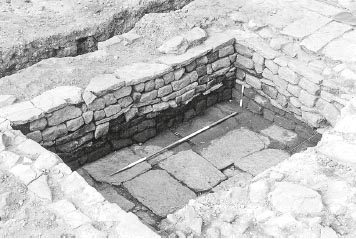
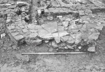
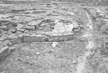
A large rectangular cistern was constructed in the south-east corner of the courtyard either in this phase or conceivably early in the subsequent one. This was 5.30m long (4.50m internally) and was slightly wider at its west end than its east end, the respective dimensions being 3.95m (3.20m internally) and 3.70m (3.00m internally). The floor of the cistern was composed of large rectangular flagstones (N11:32), up to 1.10m in length, the edges of this floor being overlapped by the sidewalls. The bottom two courses of the side walls (N11:10–12, 23) were constructed of faced stone blocks, then a string course of flagstones, followed by another course of faced stones, then a further flagged string course, another two courses of facing stones and a final string course level giving the cistern a total depth of 0.83m from this point. Its resultant capacity was calculated at c. 12.62m3. Up to two further courses of stone blocks stood above this level, but these had not survived completely. These side walls were bonded with mortar and could be seen to be faced on both sides, predominantly with small blocks averaging 0.10–0.20m in width. A very narrow fill of small rubble pieces was incorporated between the two faces giving the walls each a total width of c. 0.30–0.40m. Most of the upper courses of the west wall were missing, with only a short stretch of the outer face surviving there and at the western end of the north wall. The courses all appeared to dip down particularly towards the centre of the cistern’s north wall which had evidently bulged inward and subsided somewhat.
A layer of dark grey sandy silt (N11:31) was present in the bottom of the tank over the flagged floor. The silt incorporated a number of facing stones (N11:30) which mainly lay close to the sides of the cistern and had presumably collapsed from the side walls above, leading the excavators to suggest that those walls may once have stood one or two courses higher than surviving. The later flagged surface (M11:07, N11:14), attributed to Phase 3v, which was laid in the courtyard immediately to the north of the cistern, certainly respected the line of the cistern wall (N11:12), even though the uppermost course of that wall dipped below the level of the adjacent flagging. It is possible that the cistern sidewalls were heightened during Phase 3 to match the level of the courtyard resurfacing.
A stone-lined overflow channel (N11:21), c. 0.25m wide and a minimum of 0.35m deep, led away from the east side of the cistern towards the south-east, continuing (as N12:22) through the south-east corner of the building (see below – The east range). The side walls (N11:05) lining the conduit were composed of sandstone blocks with up to two courses surviving. The outflow point for the conduit was located midway along the east wall of the cistern (N11:10). The site photographs show that the second course of the conduit sidewalls was level with the very top course of the cistern’s east wall which was composed of sandstone facing blocks overlying a flagged course. The section of upper course where the outlet was located did not survive intact and it is quite feasible that there was an opening through it at that point, though none was evident in the underlying flagged course.
The cistern appears to extend across the projected line of the south perimeter drain/gutter (M11:13). It is not clear how these two structures related. The gutter may conceivably have belonged to a slightly earlier phase but could perhaps still have functioned after the cistern was constructed. There is no indication that the gutter channel fed into the cistern but the evidence may have been destroyed.
A corridor separating Rooms 2 and 3 was created by constructing a wall across the southern part of Room 2 reducing the internal dimensions of that room to 2.60m × 5.60m. Only the 0.70m wide rubble foundations (L09:18) of the new partition wall survived. The internal width of the corridor was c. 100m. It may well have continued eastward, occupying what had formerly been the south part of Room 1, in which case it would have resembled the corridors in the west (probably) and south ranges (see below), but the remains of Room 1 – including any trace of the corridor – had been destroyed by cellaring and other modern intrusions. It is conceivable that there was a doorway at the west end, which would have opened onto the alley between the praetorium and the principia (Alley 7). However, as all trace of the west wall’s superstructure, including any remains of a threshold, had been destroyed this could not be confirmed. The destruction of practically all the wall masonry in this part of the building also meant that there is no concrete evidence – in the form of obvious structural relationships between different walls, for example – that the corridor was actually inserted during Phase 2, rather than being a feature of the primary layout. No significant distinction in the foundation deposits could be discerned.
Patches of flagged flooring were also uncovered in the north-east corner Room 1 (M09:17) and the northern part of Room 2 (L09:24). The flags varied in length from 0.20m to 0.75m. These were assigned to Phase 2 by the excavators, although, again, they could equally plausibly be interpreted as primary floor surfaces, with the underlying clay soil layers (L09:26, L10:03) perhaps forming makeup or bedding levels for the flagging.
A north-south aligned corridor was also inserted along the inner side of the west range, marked by the construction of a partition wall (L11:13, L11:15). The corridor regulated movement between the courtyard and the two rooms in the range and continued across the width of the south range, perhaps terminating in a doorway through the building’s south wall, although any trace of a threshold had been robbed away with the remainder of the wall’s masonry at this point. The corridor was only recognised in the southern half of the range, during the 1979 excavations. The lack of any equivalent evidence in the northern part of Room 3, excavated in 1983, may simply reflect of the degree of post-Roman disturbance affecting this part of the building, which presumably also explains the absence of any floor surfaces that might have been associated with Phase 2 here. However the layout proposed by the excavators inferred that the corridor continued north to meet the east-west corridor aligned corridor in the north range where there was presumably a connecting doorway, although, again, no tangible evidence of such survived. As a result of the insertion of the corridor the internal width of Rooms 3 and 4 was reduced to c. 4.20m.
The excavators assumed that the full length of the corridor was inserted as a single action in Phase 2, however there are a number of irregularities in its construction which imply that the true picture may have been more complex. The corridor was apparently interrupted by the former south wall of Room 3 (L11:14). The footings of this Phase 1 wall remained in situ across the width of the corridor with different surfaces on either side (see below). It is uncertain whether wall L11:14 remained standing to its full height or perhaps now served as the threshold of a doorway between two sections of the corridor. If the latter was the case it is unclear why such a doorway was needed. What is apparent is the markedly different character of the corridor wall to the north (L11:13) and south (L11:15) of wall L11:14. L11:15 was c. 0.60–0.65m wide and constructed of dressed stones facing a mortar-bonded rubble core, all set on clay packed rubble foundations (L11:35), like most walls of the praetorium, and still had layer of plaster, some 20mm thick, adhering to its east face. In contrast, L11:13 was much narrower (c. 0.44m) and consequently was just composed of mortar-bonded facing stones, with scarcely any rubble core. The foundations of L11:13 are described as ‘small angular sandstone rubble’ (L11:44), with no mention of clay packing. Equally significantly, its alignment was offset slightly to the west of that of L11:15.
The only level recorded in the corridor south of partition wall L11:14 was a layer of decayed plaster fragments in light grey clay loam (L11:17, L12:65). To the north of the wall, a sandy stony level with some silt (L11:49), was assigned to this phase, being the lowest level exposed in this area. The remainder of wall L11:14 was demolished down to its rubble and clay foundations (L11:33) and Room 3 extended 4.40m southward. A new floor was laid there, directly overlying the foundations of the room’s primary south wall (L11:33) and composed of river-washed cobbles and pebbles (L11:11a). These varied in length between 0.03m and 0.20m, but averaged c. 0.07m, and were closely packed to form a hard, even surface. Thus enlarged, the internal length of Room 3 could potentially have been as much as 18.70m, although it is quite possible that there was another cross wall in the 5.0–6.0m wide unexcavated strip in the centre of the range, which would have divided the latter into more manageable rooms. A newly constructed wall (L11:21), which was bonded with corridor wall L11:15, formed the new division between Rooms 3 and 4. The new wall was mortar-bonded and set on clay-packed rubble foundations (L11:36) in the usual manner. The southward extension of 3 reduced the internal length of Room 4, from north to south, to c. 5.30m. A surface (L11:40) of dark grey silt incorporating off-white mortar/plaster lumps and overlying a level of small dirty yellow sandstone fragments was recognised along northern edge of the room. This was not exposed in the adjacent corridor or in Room 3 and was therefore presumed to represent the Phase 2 floor.
A similar corridor was created in the south range by constructing a new wall (M12:05, N12:14), c. 1.35m to the south of the range’s pre-existing north wall. The new wall, which survived up to two courses high, extended from a junction with the west corridor right through to the east side of the building, and provided the clearest evidence that it was a secondary insertion where it overlay the remains of the west wall of northsouth passageway (Room 7 – see below). It varied in width between c. 0.60m and as much as 0.75m, further east, and was similarly constructed to the primary walls of the building, with medium-sized facing stones of fine-grained sandstone keyed into a rubble core and bonded with off-white, gritty mortar, but it lacked foundations. The westernmost 4.40m of the wall had been removed by later robbing (L12:11, M12:19), as far as the possible east jamb of a doorway connecting the corridor with Room 5. Access to and from the courtyard was maintained via the primary doorway (N12:19) at the south-east corner, and there may have been other entrances further west which provided access into different sections of the corridor, but no evidence survived.
A patchy surface (L11:41, but actually in grid squares M11 and M12), composed of small, worn pebbles averaging c. 30mm in length, was exposed towards the west end of the corridor. This was covered by a layer of grey ash, silt and charcoal, c. 20mm thick, representing occupation debris. Both these layers respected the west face of primary wall M12:11 (the original partition wall between Rooms 5 and 6) where the latter extended across the line of the corridor. It is conceivable, therefore that the corridor was divided into sections, perhaps with connecting doorways on the site of earlier walls M12:11 and threshold N12:15. Further to the east, the 0.70m square sondage excavated against the south wall of the corridor revealed a grey sandy silt (M12:96) overlying the primary floor surfaces and occupation deposits of Room 6 (recorded in section S62). This was interpreted as the Phase 2 level here, although the description seems more characteristic of an occupation level than a new floor surface which might have accompanied the construction of the corridor.
The internal dimensions of Room 5 were reduced to 4.50m, east-west, × 4.20m, north-south, by the creation of the corridor. A small pocket of a possible floor makeup level survived in the north-west corner of this room, in the form of a layer of off-white mortar, stone and grey-brown sandy loam (L12:57).
Room 6 was subdivided into two unevenly sized rooms by a stone partition wall (M12:73). This wall was demolished in the subsequent phase, leaving only stubs surviving at either end, in the form of two facing stones bonded to the south wall of the building and one block projecting from the south face of the corridor wall. This showed the wall was 0.65m wide, bonded with off-white gritty mortar and set on clay packed foundations. The site plans (e.g. P175 and P206) suggest that corridor wall may actually have butted up against the east face of the partition (there was a doorway on the west side) implying that the latter was structurally earlier than the corridor wall. However the evidence is not conclusive and in any case the small sondage dug against the north face of the wall showed that the partition wall definitely did not continue onward to reach the north wall of the range, unlike the primary partition walls, indicating that this structure was essentially contemporary with the Phase 2 corridor rather than belonging to Phase 1.
The western room (6W) was much the smaller of the two and was narrower from east to west than north to south, measuring only 2.40m × 4.25m internally. No floor surface associated with this phase was identified but evidence for a possible entrance from the corridor was identified in the room’s northeast corner, the width of the doorway being estimated at roughly 0.75m. The other room (6E) measured 4.15m north-south by 6.60m east-west and comprised the central and eastern parts of the original Room 6. A patch of flagging (M12:88a) was exposed between pilae of the later hypocaust (M12:80 N/O/P) in the southwest corner of the room. The flagstones ran up to the bottom course of the south wall and were interpreted as part of a floor associated with this phase. Along the north side of the room traces of plaster covered the face of wall N12:14.
In the south-east corner of the room, as was noted previously, the gravel makeup or surface (N12:57), overlying pink clay floor (N12:56) and charcoal and coal debris (N12:54), which were discussed in relation to Phase 1 and allocated to that phase in the overall context database listing, may instead have been laid down in Phase 2 or at any rate continued in use into this phase as the context listing implies. Indeed the phase plans appear to associate the charcoal/coal debris N12:54 with the possible hypocaust channels of Phases 3i–ii (N12:50). A thin strip of mixed grey clay loam (N12:51), with charcoal and orange and white clay flecking, noted in plan (site plan P200), was thought to represent the remnant of a more extensive surface cut by the later hypocaust walls of Phase 3i–ii, and might therefore have also belonged to this phase. The grey clay was considered by the excavators to have been cut by a band of pink clay (N12:53) which was thought to represent the foundation packing for a much later (Phase 3v) north–south wall (M12:06, N12:21). However comparison of site plans P200 and P203 suggests that the grey clay may actually have overlain the pink, implying that N12:53 might simply have formed part of the same floor level as pink clay N12:56.
The wall on the south side of the corridor (N12:14) extended 0.35m beyond the west side of the passageway creating a 1.10m wide doorway connecting the two. The clay-packed angular rubble foundations (N12:62) of the corridor wall actually extended right across this doorway cutting through the earlier floor levels and occupation debris. North of the doorway, overlapping the northern edge of foundations N12:62, a surface of clean, very fine, yellowish mortar (N12:63) was present over the corridor. In the southern part of the passage, the pink clay floor (N12:59) noted under Phase 1 may actually have belonged to Phase 2 instead, or at any rate continued in use in this phase. It was assigned, with a question mark, to Phase 2 in the context database, but was shown on the Phase 1 plan.
In the south-east corner of the building, the corridor continued as far as the east wall and the remainder of Room 8, like Room 6, was divided in two by the construction of a new north-south aligned partition wall, of which only the 1.00m wide sandstone rubble foundations (N12:29) survived. The corridor wall, too, was represented only by the rubble foundations (N12:36), with air pockets visible amongst the sandstone and some clay packing remaining towards the west. The western of the two rooms (8W) thus created was almost square, measuring internally c. 4.25m from east to west by 4.15m north-south, whilst the eastern room (8E) was smaller, its internal dimensions being estimated at c. 3.00m east-west by c. c. 4.10m north-south. The entrance into the western room, from the corridor, lay in the north-west corner of that room, where the foundations of the corridor wall stopped c.1.20m short of the west wall (N12:16). There was no evidence regarding the position of the doorway into Room 8E and no floor surfaces or deposits attributable to this phase were uncovered in this part of the corridor or in either of the two rooms.
No trace of a corridor remained along the inner side of the east range, similar to those in the other ranges of the building, although, given the degree of devastation caused by later disturbance in this area, this does not represent conclusive proof that none was ever constructed. The drain channel or conduit (N11:05, 21, N12:22), which led from the cistern in the south-east corner of the courtyard and perhaps represented an overflow channel for that tank, ran diagonally across the south-west corner of Room 9, cutting through foundations of the west wall of the range (N11:09, 13, 17, 18, N12:07), then though the room’s south wall (N12:30). This channel was c. 0.25m wide and a minimum of 0.35m deep, with up to two courses of the side walls remaining, and was filled with deposit of silt (N11:21, N12:23). Immediately before it cut through the south wall of Room 9, the drain was joined from the north by another channel, only one side wall and a 1.35m length of which survived. A further, 1.10m long stretch of the conduit (P12:05) was noted in the northern part of Room 8E. The channel probably passed through east wall of the building, near to the south-east corner, and connected with the adjacent main storm drain which ran alongside the intervallum road (P12:07). It is conceivable that this system of channels served to flush a latrine, either in Room 9 or 8E, or conceivably formed part of a system of stable drains, but there was no direct evidence, the surviving remains being cut right down into the orangey clay subsoil (N11:06) with no trace of any superstructure being preserved in this part of the building.
FINDS
Bone: ring (no. 58, L11:11)
Bone: pin (no. 16, L11:29)
The Phase 2 assemblage has a high proportion of rims and is almost certainly missing a number of body sherds. The courtyard (M11:11–12) produced only eight surviving sherds, the cistern wall and drainage channel (N11:21, 23) nine, and Room 6 (N12:54) four, mainly consisting of BB2 and locally produced wares of the late second century. The silt in the corridor (L11:29) produced a mid to late Antonine Form 31. There were only 13 sherds in the silt in the cistern (N11:31) including a Form 18/31 of the late second or first half of the third century and sherds of BB2.
This assemblage could all easily be mid- to late Antonine equivalent to Fort Period 2.
The excavators assumed that the praetorium underwent a straightforward development from a very simple primary plan, consisting of ranges of rooms laid out around a roughly square courtyard, to a slightly more complex Phase 2 plan with corridors inserted along the length of most if not all the ranges regulating access and circulation from the courtyard. However, whilst this hypothetical development is not implausible it by no means certain either. It is entirely possible that the building’s layout was more complex from the start, with some sections of corridor already incorporated in the Phase 1 praetorium. To be sure there was clear evidence that the corridor in the south range was secondary – namely the relationship between the west wall of the passage (Room 7) and the south wall of the corridor – but the irregularities observed in the west corridor might imply that this feature was constructed in two separate stages. Thus the section in the south-west corner could conceivably have belonged to Phase 1, whilst the corridor’s northward continuation was perhaps added in Phase 2, when corridors were inserted in the other ranges. The function of the primary southernmost section of corridor may be explained if there were two rooms in the south-west corner of the building during Phase 1, rather than one (Room 4) as assumed by the excavators. These two rooms (4N and 4S) would have been separated by wall L11:21, which, like corridor wall L11:15, would therefore have been a primary feature, whilst wall L11:14/L11:33 would have formed the northern limit of Room 4N and the short section of primary corridor. The corridor would served to give direct access to both rooms without the need to pass through 4N to reach 4S.
The square structure (M10:19) in the north-west corner of the courtyard was evidently demolished at some stage. The remains of its foundations were covered by a spread of yellowish gravel and silt (M10:06) which extended eastward into the courtyard where it was in turn overlain by a patch of rubble, silt and ash (M10:03), including displaced cobbles. To the east lay a surface of small, well-worn cobbles set in crushed grey gravel (M10:02), which, along with the rubble, might represent the remains of a resurfacing of the courtyard, both layers being overlain by a 4.50m wide area of broken flags (M10:04) along the southern edge of the 1983–4 excavation site. No dateable material was recovered from any of these contexts, which in any case directly below modern disturbance, so the chronology of this resurfacing is uncertain. Moreover the complete removal of any superstructure and interior remains of the square structure in the corner of the courtyard might suggest a degree of truncation occurred during or after its demolition.
Across most of the southern part of the courtyard, a new surface of gravel and cobbling (L11:18, M11:08, N11:34, 35) was laid, set in an orange sand. The overall colour was predominantly orange, but sometimes yellow. It incorporated small pebbles or cobbles up to 0.05m across, with some larger cobbles, up to 0.15m across, to the west, again set in orange sand and pebble matrix. To the east of the cistern, a mixed pebbly spread of grey-brown silty clay, rubble chips and off-white sandstone pieces (N11:15) was present. On the west side of the cistern it was possible to differentiate between the orange gravel top surface (N11:34) and an underlying layer of fairly small, worn cobbles beneath (N11:35). It is possible that this distinction prevailed everywhere. In removing part of M11:08 the excavators noted that it could have comprised several layers recorded as one. It is not clear whether the cobbling was actually made up of two or more distinct sub-phases of courtyard surface, or whether such apparent layering simply reflects the manner in which the courtyard metalling was constructed. It was tentatively assigned to Sub-Phase 3i, although useful stratigraphic links with the complex sequence of activity in the south range, which provided the basis for the detailed phasing of the building, were lacking and, as noted above, it is possible that the gravel and cobbling actually represented more than one sub-phase.
At some stage during Phase 3 a new surface of grey sandy silt (L11:46) was laid in the section of the west corridor north of wall L11:14. No corresponding surface was noted to the south of the wall.
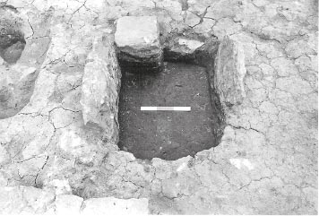
The wall separating Rooms 6W and 6E (M12:73) was evidently demolished at this stage and Room 6 restored to its original size with short stub walls being inserted to support the raised floor for a hypocaust heating system. The doorway into the former west room (6W) was blocked up (M12:21) as part of these alterations. The blocking was composed of flat, slablike stones, somewhat larger than those originally used to construct the corridor wall (M12:05, N12:14). Four courses of this blocking, some 0.45m high in total, survived, the bottom of the blocking being on a level with the bottom of the hypocaust walls. The flue to fire the hypocaust was located at the south west corner of the room. The east side wall of the flue (M12:09) was the better preserved, with almost all of one course surviving, and was 1.80m in length, north–south, and up to 0.90m wide. Only part of the stokehole face of the west wall remained (c. 0.90m), however, the rest having been destroyed when a square apse was constructed immediately to the west in Sub-Phase 3iv. The flue channel averaged c. 0.50m in width, and was floored with several large flags (M12:70), up to 0.65m long and 0.10m thick. The maximum surviving depth of the stokehole was 0.30m and its sides were blackened and reddened through heat. (See below – The area south of the praetorium: Phase 1 – for discussion of the possibility that the flagged floor of the flue represented a reused, primary drain outlet from a bath suite in the south range, which connected to a stretch of drain seen further to the south-east (N13:29).)
Figure 9.12: Initial flagged floor M12:51 in apse M12:08 from the south. The earlier hypocaust vents in the south wall can be seen in the background.
Two narrow vents through the south wall (M12:49, 50) were probably also inserted at this stage, roughly mid-way along the length of Room 6. The vents were spaced 1.15m apart, centre to centre, the eastern one (M12:50) being 0.19m wide and 0.30m deep (as surviving), whilst the western was similar width at its southern end but narrowed to as little as 0.12m at its northern outlet, the irregularity of its channel demonstrating these were secondary features in relation to the south wall. Both vents were filled by rather dirty greeny-grey clay loam or silty clay (M12:49) and grey-brown silt loam (M12:50) flecked with stone and mortar, which was presumably allowed to accumulate during later sub-phases when the vents were no longer deemed necessary.
Fragmentary traces of the support walls for the hypocaust survived in two places in the room. Beside the north wall, near the north-west corner, three or perhaps four short lengths of sleeper walling (M12:76–78) remained, standing up to two courses high (0.13–0.16m) and one or two stones in width. Their surviving length varied between 0.75m and 1.03m (the central wall, M12:77, incorporated a surviving fragment of partition wall M12:73), whilst the width of the intervening channels varied between 0.15m and 0.30m. The walls were set on a grey clay loam which might represent the original Roman ground surface. The walls appeared to be faced more neatly on one side than the other (sometimes the west face, sometimes the east), although such distinctions may not have been significant in what were essentially floor substructures which were never intended to be seen. A mixed level of gravel, clay and mortar (M12:87) noted in the north-west corner of Room 6 might represent construction debris associated with this sub-phase. In the south-east corner, other fragments of walling (N12:50), which were originally interpreted as a possible latrine, may have belonged to the heating system sub-flooring. One wall, evidently only partially preserved, extended c. 2.00m northward from the south wall. It was faced on its east and north sides (the latter face being 0.65m in length), with a deposit of yellow-white mortar filling the west side the facing stones were largely missing. Some 0.35m to the east a further two facing stones might represent the very fragmentary remains of the west face of another wall on the opposite side of the hypocaust channel, whilst at the southern end of the main wall another channel appeared to curve round from its south-east corner to the west side of the wall. It is possible that the spread of charcoal and coal intermixed with a little grey silt (N12:54), to the north of the hypocaust wall fragments, was also associated with the hypocaust rather than representing an earlier occupation deposit (see Phase 1 and 2 descriptions of Room 6 and 6E for previous discussion). It is shown on the research archive Sub-Phase 3i and 3ii plans although the relevant context sheets indicate that walling N12:50 overlay the coal/charcoal spread.
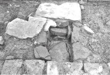
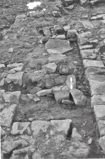
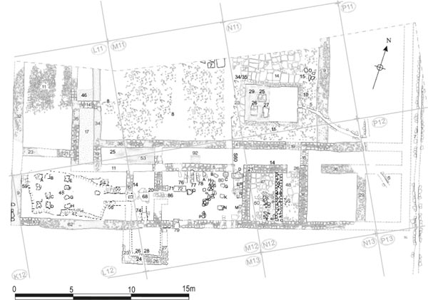
In the passage, a rather patchy flagged floor was laid (N12:48), of which two large slabs survived in the centre of the room (one overlying ‘drain’ N12:58) with smaller flags along the southern edge of the doorway, including a threshold pivot stone (N12:26) positioned right beside east wall. Elsewhere all that remained was a scatter of small stones and patches of pink/grey streaky clay to judge from site plan P200. Into this flagged floor was set a ‘drain’ or soakaway feature (N12:58) which extended across the width of the passage, from east to west, and was composed of two lines of facing stones set on either side of a flagged base (Fig. 9.10). The side walls were placed 0.50m apart, narrowing to 0.35m at its west end. Three packing stones were wedged in towards the eastern end of the feature, which was covered by a large flagstone (part of floor N12:48) sealing a deposit of loose grey sticky silt (N12:61). The remainder of the drain/soakaway was filled by a very loose packing of stone rubble and brown loam with slight traces of charcoal (N12:55), perhaps representing the backfilling of the structure at the end of its life.
A new floor surface composed of yellow gravel and mortar (L11:28), c. 20mm thick, was laid in the western section of the corridor. This was overlain by a 40mm thick deposit of occupation material (L11:26), consisting of pink clay, coal, charcoal and silt. The small sondage in the central section of the corridor showed that a new floor was laid in that area too, made up of yellow-white gritty mortar (M12:95), some 0.11m thick, covered by a thin occupation deposit of grey sandy silt (M12:94).
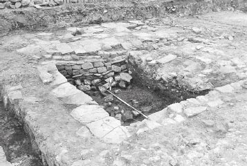
A semi-circular apse (M12:08) was added against the outer face of the south wall (Figs 9.12, 9.13), opposite the eastern part of Room 6 and overlying the street surface of worn orange sandstone cobbles (L12:38, M12:39), which extended along the south side of the praetorium. The east-west width of the apse, at its broadest point next to the building’s south wall, was 4.10m and its maximum extent from north to south was estimated at c. 2.80m. The enclosing wall was up to 0.57m wide and of typical mortared construction, surviving two and sometimes three courses high. Its western end blocked the westerly (M12:49) of the two narrow vents through the south wall which were inserted during the previous sub-phase.
Figure 9.14: Building 13, Phases 3.iii and 3.iv with inset showing second phase of flooring in the semi-circular apse at 1:200
The apse underwent a series of alterations over the course of its life. A floor of fine grained sandstone flags (M12:51) was present in the southern half of the structure. This had settled unevenly so that it no longer formed a flat surface when excavated and abutted the middle or top of the second course of the apse wall. The flagged floor was replaced by a hard mortar floor, also described as a ‘concrete floor’ in the context records and represented by a 0.10m thick level of very gritty, hard off-white mortar (M12:46), which directly and almost exactly overlay the area of surviving flagstones and butted against the third course of the apse wall. Both the flagging and the mortar surface had presumably floored the entire apse originally, to judge from the irregularity of their northern edge, but had been partially removed during later alterations. The residue of those alterations was a layer of mixed stone rubble and various off-white and creamy brown mortars (M12:82) in the eastern half of the apse, between the flags and the main south wall of the praetorium, whilst a black silty deposit containing the odd stone and flecks of mortar (M12:83) was observed in western half. The mortar floor was reinstated in the north-east part of the apse, over rubble and mortar debris M12:82, in the form of a very hard creamy mortar spread containing various patches of yellow/white clay (M12:16). In contrast, a 0.25m thick ‘foundation’ layer of orange pink plastic clay (M12:31) was dumped over the black silty deposit (M12:83) in the north-west corner of the apse, where the mortar floor was absent. This clay which extended up to 1.40m from east to west and 0.95m north–south, may have provided the base for some kind of structure. The later phases of apse flooring may coincide with the subsequent overall sub-phases of the praetorium. Other arrangements relating to the hypocaust were unchanged.
Figure 9.17: View of the stoking chamber from the west hypocaust with the west flue in the fore and the east flue in the far background. The south flue is to the right beyond the later crosswall.
In the western section of the south corridor a 30– 40mm thick layer of yellow mortary grit (L11:27) was recorded, overlying the earlier occupation deposit (L11:26). This was only present along the north side of the corridor and may represent a partial resurfacing attributable to this sub-phase.
These sub-phases of the Daniels/Moffat sequence were characterised by the shifting of the main hypocaust from Room 6 to the south-west corner of the building, where it took over the entire area of what had formerly been Room 4, the southern end of the west corridor and the western half of Room 5. The flue for the hypocaust in Room 6 (M12:70) was blocked with a couple of large facing stones and pink clay (M12:79- see Fig. 9.15) and the excavators seem to have assumed that the semi-circular apse (M12:08) to the east was taken out of use and demolished at the same time, although no surfaces or structures attributable to this sub-phase were identified in Room 6.
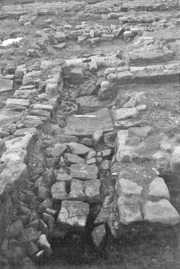
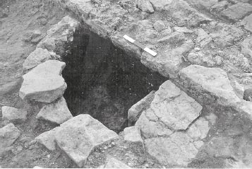
The eastern half of Room 5 was divided off from the new hypocaust by the construction of a partition wall (L12:15, M12:14), up to 0.55m wide. The narrow chamber thus created, which measured c. 4.30m northsouth by 1.90m east west, became the area from which the hypocaust was fired. The stokehole was floored with two large flagstones (L12:67, M12:68), 0.85m and 0.95m in length and both c. 0.65m wide, which were blackened and scorched by heat. The flue was 0.65m wide, its side walls (L12:55, 56) projecting up to 1.80m westward into the hypocaust area (Figs 9.16–9.18). These comprised single-faced walls surviving up to three courses high, with rubble backing, their recorded width varying between 0.20m and 0.35m. The flagged base (L12:67/M12:68) was only found in the flue opening in wall L12:15//M12:14 and extending eastwards in the stoking chamber. To the west, between the two side walls of the flue (L12:55, 56), the bottom was formed by a layer of rubble (L12:74). This rubble abutted the lowest course of the flue sides whereas the flagging was level with the second course. In the context notes it is suggested that the rubble formed the base of the flue during its first phase whilst the flagging was associated with a second phase. However, this may be to overcomplicate the sequence. At the flue opening, the northern edge of flagstone L12:67 was marginally overlain by wall L12:15/55/M12:14, which would imply that the flagging cannot be part of a secondary arrangement of the flue unless the west wall of the stoking chamber – one of the defining features of the sub-phase – was also secondary. In contrast, at its western end, flagstone L12:67 sat on top of the lowest, slightly offset, course of flue side wall L12:55. The simplest explanation is that all three features – west wall L12:15/M12:14, flue wall L12:55 and flags LL12:67/M12:68 – formed part of a single contemporary construction work. Examination of the site photographs suggests that L12:74 actually consisted of some rubble blocks (perhaps deriving from the partial demolition of the flue walls at a later stage) overlying a layer of flagstones in the base of the flue channel. Although somewhat smaller in size than flagstones M12:68 and L12:67, and set at a slightly lower level, the flags in the flue channel probably nonetheless represented a continuation of the large slabs in the stoking chamber and the flue opening since flagstone L12:67 itself appeared to sit at a slightly lower level than those in the stoking chamber (M12:68). Thus the flagstones in the flue probably stepped down gradually from the level of the stoking chamber floor to the bottom of the hypocaust and all were probably laid at the same time.
Charcoal (L12:60), presumably representing furnace debris, was noted in the bottom of the hypocaust spreading westward from the end of the flue, overlying mortar and stone construction debris. Similar mortar and stone debris (L12:49) was noted in the western part of the hypocaust, although it was not possible to determine whether that debris related to the construction or demolition of the hypocaust.
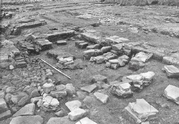
The pillared hypocaust (L12:48) was constructed using pilae constructed of slabs, flagstones and reused facing stones of varying thickness, set in a oblong pit up to 7.00m long from east to west by c. 3.00m north to south. Eleven of these pilae survived to some degree. They were near square or sub-rectangular in plan, with sides ranging between 0.40m and 0.50m, and were disposed in north-south aligned rows of each consisting of four pilae. The two most westerly rows (comprising pilae A, I and J, and B, C, and D) were each missing one of their pilae (between I and J and B and C respectively). The next row to the east had been entirely destroyed by the subsequent construction of a pitched stone wall foundation (L12:46). All four of the pilae (E-H) in the fourth row survived, but only one example remained in the eastern half of the pit, near the end of the flue. Pila A, in the north-west corner of the hypocaust, was the best preserved, standing 0.55m high and made up of six courses, comprising two thick slabs, one above the other, a course of facing stones, a thin slab and two flags. In this form it was probably completely intact, the pieces of flagging on top perhaps forming part of the floor (suspensura). Of the other pilae, B-H were substantially intact, standing between 0.40m and 0.22m high, and doubtless owed their survival to later reuse to contain the packed stone foundation (L12:46), whilst I and J had been demolished down to the reused facing stones which formed their bases.
Figure 9.19: Remnants of south flue M12:74, from the east, in the southern part of the stoking chamber incorporated in later flagged floor L12:70 after the room was subdivided.
A short length (1.80m) of the hypocaust pit’s stone revetment survived on the south side (L12:47), comprising four or five courses of slabs and blocks, bonded and backed by pink clay. The side sloped down with a slight batter. It was cut away immediately to the west by the later packed stone foundation and beyond that had been robbed away. A mass of plastic pink clay in the north-east corner (L12:54) might represent part of the clay backing of the corresponding revetment on the north side of the pit. No trace of an equivalent lining was recognised on the west side of the pit, and the excavators suggested that none may ever have existed there, but a small area of flagged flooring did survive at the western edge of the room (L12:59). Together with the flagstones on top of the adjacent Pila A and others that had apparently collapsed into the intervening part of the pit (L12:35 fill), this flagging probably represented a remnant of the floor which covered the entire hypocaust chamber. Certainly there was no indication that the room was ever floored with opus signinum or concrete.
A channel (L12:50) was also made from the hypocaust pit through the west wall, on a north-east to south-west orientation, cutting the earlier floor deposits and original ground on the western edge of the room. The cut was 0.90m wide at the top, c. 0.40m wide at its bottom, which was rounded and some 0.45m deep. No trace of any stone lining was recorded. The excavators considered this represented a drain channel (from water tanks in a bath suite?). It may have connected to a drain flowing southward alongside the exterior of the west wall. Such a drain does appear to have existed at the south-west corner, but no clear evidence of a junction was seen.
Opposite the southern end of stoking chamber, a roughly square apse, measuring 3.90m east-west by 3.15m north south, was attached to the exterior of the building. Its walls (west: L12:23; south: L12:24, M12:26; east: M12:27) rested directly on the earlier (Phase 1 or 2) cobbled street surface (L12:38, M12:39), with no foundations, and were up to 0.65m thick with a 0.22–0.28m wide stone ledge (L12:26, M12:28) set alongside the inner face of the south and east walls (the west wall was too badly damaged to determine whether it was once furnish with an equivalent ledge, although it appears quite likely that it was). Some of the facing stones, which were a mixture of coarse and fine grained and micaceous sandstone, showed signs of fire-reddening, on the east wall, for example. Only one course survived, and this showed signs of surface wear on top. The apse was filled with a jumble of cobbles, pebbles and mortar in a grey silty clay loam (L12:25, M12:24) some 0.10m deep, which may represent the later backfilling of the structure after it had gone out of use. The structure was tentatively interpreted as a possible hot room of a bath suite, although its position, isolated at the end of the stoking chamber, would seem to exclude such an identification. The square apse also resembled an external furnace chamber, but such an interpretation would likewise be difficult to reconcile with the evidence that the adjacent room of the praetorium functioned as a stoking chamber, representing an apparently unnecessary duplication. It is likely however that the function of this structure was related to the remains of a possible flue identified just inside the praetorium, immediately to the north of the apse (Fig. 9.19). These remains took the form of a patch of cracked flagstones, measuring 0.46m by 0.70m and flanked by a pair of single-faced walls (M12:74) standing one course (0.12m) high, all sitting directly over the earlier sandy clay floor (L12:51, 69, M12:88). The walls appeared burnt, with quite a lot of charcoal around, and the structure, which was c. 1.00m wide overall, was interpreted as a possible hearth or fragment of a hypocaust flue and assigned to Phase 3iii or 3iv by Moffat. The remainder of the flue, to the north, had probably been destroyed by a later wall (L12:21, M12:10), belonging to Phase 3vi, whilst, to the south, it may have been associated with a corresponding gap noted in the masonry of the praetorium south wall. This was described as oblique and narrow in the context records, with additional comments indicating that it was considered more likely to be the result of later robbing or disturbance than a deliberate break for a stokehole. However its recorded characteristics would perhaps be compatible with a gap which was knocked through the south wall as a secondary modification, which is what is proposed here. In these circumstances the flue may have been fired from the same point in the stoking chamber as the west hypocaust, and the square apse might conceivably have housed a hot water tank heated by that furnace. Such a tank could have been mounted on the ledge (L12:26, M12:28) running along the inner face of the apse walls and would presumably supplied a bath suite within the building.
Figure 9.21: Rubble in lowest fill in the courtyard cistern (below the piers), from the south west, with the courtyard flagging in the background.
Figure 9.23: The east hypocaust viewed from the south-east (Phase 3v) with Phase 3 vi east-west wall foundations M12:69 also visible to the right, reducing the area of the hypocaust.
In the south corridor, new surfaces were laid in the western section (L11:25, M12:53) and in the central part (M12:93). That towards the west end was composed of very patchy yellow sandy clay (L11:25, M12:53) interspersed with greenish grey silt. The sondage in the central part of the corridor showed another floor of yellowish white gritty mortar (M12:93) was laid here generally around 20mm deep, though thicker nearer to the south wall of the corridor.
Perhaps in Phase 3iv, a solid, roughly constructed stone platform (N12:45), consisting of large stones with an outer facing (see Fig. 9.39 below), was built against the outer face of the south wall at the end of the passageway (Room 7). One layer of stones remained. The roughly rectangular space between the stone platform and the semi circular apse, to the west, was covered by a layer of yellowish mortar (N12:65), up to c. 20mm thick, which may have been structurally related to the stone base. Alongside the south wall of the building the east-west dimension of this structure was 2.35m, almost exactly corresponded with that of the passageway, which narrowed to c. 2.10m along its southern edge, the breadth of the structure from north to south being 1.40m. Initially, tentatively interpreted as a buttress, its function may have been related to the activities being carried out in the passage and adjacent rooms and it was subsequently suggested that it might represent the support for a water tank perhaps associated with a bath suite in the heated rooms of the south range. Any doorway at the south end of the passage, if one existed was presumably blocked by this structure.
There is clear stratigraphic evidence that construction of the stone base took place at some point after the addition of the semi-circular and square apses to the south range. Both the stone base and the associated mortar spread (N12:65) were set on top of the extensive layer of grey silty clay loam (N12:69, N13:03, L12:14, L13:38, M12:38, M13:24), which was deposited over much of the area south of the praetorium at some stage during Phase 3, whereas the clay loam, for its part, was laid right up against the walls of the semi-circular and square apses and the stoking flue, making it apparent that it post-dated those structures. On the other hand the base was marginally overlapped by the foundations of the north wall of Building BB (N12:43, N13:28), showing its construction preceded that of BB. After its demolition, during the latter stages of Phase 3 or perhaps Phase 4, the base was covered by a spread of light, browny-yellow clay loam and mortar (N12:13).
In the west range the cobbled surface in Room 3 was renewed with a further level of smallish, riverworn cobbles and pebbles including some crushed tile (L11:11), very similar to the previous floor.
To the north and north-west of the cistern, extending right to the limit of 1979 excavation area, well-laid, neatly squared-off rectangular flags (M11:07, N11:14) took the place of the gravel and cobble surface. The southern edge of this flagging respected the north wall of the cistern (N11:12), demonstrating that the cistern was already in existence when the flagstones were laid (Fig. 9.21). The flags were composed of fine-grained, slightly micaceous sandstone and were a mixture of orange, off-white and greyish/green, with grey being the dominant colouring. They generally averaged c. 0.70m by 0.75m, although the largest examples were as long as 0.90–1.05m. The laying of the flagstones was attributed to Sub-Phase 3v in the Daniels/Moffat phase plans and context database, although there were no useful stratigraphic links to permit any direct equivalence between activity in the courtyard on the one hand and the interior of the south range on the other. Over the remainder of the courtyard it is presumed that the earlier gravel and cobbled surface remained in use. Indeed M11:08 was recorded as slightly overlapping the adjacent flagstones (M11:07). It is unclear why the flagging was laid only in this particular part of the courtyard. The flagstones do not appear to have stretched beyond the line of the cistern’s eastern sidewall, but did extend beyond its west wall and their edge here appears less regular than that to the east.
A thick deposit of slightly brownish-grey silty clay-loam (N11:29) flecked with coal and pink clay lumps covered the bottom of the cistern. This was some 0.40m deep in the centre of the tank, but was, respectively, as much as 0.80m and 0.87m deep further north and south, where the deposit sloped down the sides of the tank. Three stone pillars (N11:25, 26, 27) were uncovered in the western half of the tank, set on top of this layer of silt (Fig. 9.22). The pillars were constructed of roughly faced sandstone blocks or, in the case of N11:27, superimposed flat flagstones and were bonded with orange-brown sandy mortar. A similar spread of orange brown sandy mortar (N11:28) lay beneath the northernmost pillar (N11:25), but was separated from direct connection with it by a lens of silt. The northernmost pillar (N11:25) measured 0.80m by 0.70m and stood 0.40m high; the south-western example (N11:26), which measured 0.90m (N–S) by 0.60m, was somewhat damaged and only stood 0.26m high. The south-eastern pillar (N11:27) measured 0.90m × 0.60m and stood 0.40m high. Similar structures were found in southern half of Cistern 1, to the north of the hospital, and they were presumably designed to support a floor covering at least part of the tank. Other pillars may have stood in the eastern half of the cistern which was not emptied.
A pillared hypocaust (M12:80) was inserted in Room 6 (Fig. 9.23), which was simultaneously truncated in length towards the east by the construction of a new dividing wall (M12:06, N12:21). This reduced the dimensions of Room 6 to 7.00m by 4.20m. The wall was up to 0.68m wide and of typical construction, featuring fine-grained sandstone facing stones bonded with gritty, off-white mortar, the core also containing several tiles. A doorway in the north-east corner of the room provided access from the corridor. A total of 16 pilae (A–H, J–Q) belonging to the hypocaust survived, most of which were located in the eastern half of the room. They were mainly composed of flat slabs, though some stone blocks were used, notably in A, which resembled the earlier dwarf walls immediately to the west (and might even represent another one of those, rather than a pila of this sub-phase). Single upright blocks were incorporated in P and Q, the one in the latter case being interpreted as a possible altar (but does not appear to have been retained as small find). Many of the pilae were not fully exposed so their full height could not be accurately gauged. However, Pila C, which was measured from its base, stood to a height of 0.55m and was composed of seven slabs. The size of the pilae varied considerably, with Q and O amongst the largest, measuring 0.50m square and 0.58m × 0.45m respectively, whilst the plan dimensions of M were no more than 0.30m × 0.27m (the respective recorded heights of these three pilae were 0.33m, 0.42m and 0.45m). Along the northern side of the room, the dwarf walls (M12:76–78) of the previous hypocaust were probably incorporated in the new layout since these survived standing to much the same height as the pillars.
The hypocaust was fired from the west end of the room using the same stoking chamber from which the west hypocaust was heated. Only the north side of the flue was preserved (Fig. 9.24). The surviving flue side wall (M12:71) was bonded to the west side wall (M12:11) of the stoking chamber, which was carefully rebuilt at that point (M12:20), and projected c. 0.50m into the hypocaust. The combined length of flue (M12:20 and 71) was 1.23m. Its width could not be gauged with certainty, but it was probably in the order of 0.70m, the bottom of the channel being floored with small flagstones (M12:86) along its full length. The projecting side wall was the width of two facing stones, splaying slightly from 0.35m at its junction with wall M12:11 to 0.43m at its eastern end. Some 0.40m further east and directly in line with the flue wall there was a stone base (M12:72), measuring 1.05m east-west by 0.50m north-south. Like the flue side wall, it was composed of two lines of facing stones with no real core. It was interpreted as the support for a bath and perhaps functioned with a corresponding base to the south so that the bath supported by these bases would have straddled the flow of heat from the flue. The side wall of the flue opening (M12:20) was heavily burnt to a pinkish red colour. The nearest stone pila, of the hypocaust (M12:80Q), immediately to the west of base M12:72, also showed signs of burning.
A general level of grey, stony, sandy silt (M12:61–63) was encountered in the bottom of hypocaust right across the north-west part of the chamber, overlying the earlier construction debris (M12:87). This deposit may have built over the entire life of the east hypocaust. The corresponding silt deposits (M12:47–48) found between dwarf walls M12:76–78 contained a high concentration of animal bones but relatively little charcoal.
Contemporary with the construction of the new partition wall (M12:06, N12:21), the west wall of the north south passage (N12:46) was demolished to create an enlarged Room 7 also encompassing the former eastern end of Room 6. Thus remodelled, the room was almost square with internal dimensions of 4.15m east-west by 4.10m north-south. It is noteworthy that the new west wall (M12:06/N12:21) appeared to cut very neatly through the room’s north wall (N12:14), suggesting the latter may have been rebuilt at the same time. A flagged floor composed of thick, regularly proportioned slabs, up to 0.45m in length, was laid in the north-west corner of the room (N12:47), alongside walls N12:14 and M12:06/ N12:21. The slabs extended eastwards towards the footings of demolished passage wall (N12:46), which were probably also incorporated in the floor along with the pre-existing patchy flagged surface of the passage (N12:48) and the demolished remnants of earlier (Phase 3i–ii) hypocaust walls (N12:50) in the south-west corner. A light grey-brown loam containing a lot of mortar (N12:52) covered the area between the demolished remnants of the hypocaust and the footings of the former passage wall. The doorway into the room remained unaltered. It was perhaps at this stage that the enigmatic stone-lined feature (N12:58), interpreted as a possible drain or soakaway, was backfilled with a very loose packing of stone rubble and brown loam, including slight traces of charcoal (N12:55).
A new floor level revealed in the sondage in the central part of the corridor was attributed to this sub-phase by Daniels and Moffat as expressed in the context listing and the phase plans. It was composed of a layer of pinky grey-brown clay (M12:92), as much as 0.08m deep.
On the Daniels/Moffat phase plans nothing is shown in Room 6 in respect of Sub-Phases 3iii–iv whilst the west hypocaust was functioning in the south-west part of the building and conversely the south-west part of the building appears empty in Sub-Phase 3v when the new pillared hypocaust was constructed in the reduced Room 6. Rather than envisaging a kind of structural vacuum in either room, it would seem more plausible to conflate these sub-phases, with the implication that both hypocausts were in operation simultaneously and were heated from the same firing chamber, as apparently was the square apse. This would have made efficient use of space in the south range.
Thus, instead of presenting the development of the two hypocaust rooms as a sequence of discrete and mutually exclusive sub-phases, their structural history can be seen as overlapping and proceeding in parallel. When the west hypocaust was constructed and the internal firing chamber created, the original east hypocaust with its associated semi-circular apse was probably still fully functioning. The only change was the blocking up of the external stokehole and its replacement with a flue at the west end of the room, fired from the stoking chamber. Indeed there is some evidence that the firing chamber may have been functioning in relation to the east hypocaust before the west hypocaust was operating. A spread of charcoal (M12:90) found underlying flags M12:68, and evidently representing furnace debris, indicates that a flue was functioning in this area before flags M12:68 were laid. Since the laying of the flags was probably contemporary with the construction of the flue serving the west hypocaust, for the reasons outlined above (see Sub-Phases 3iii–iv), the charcoal spread most probably derived from the flue serving the east hypocaust which was more closely associated with flags M12:86 rather than L12:67/M12:68. This interpretation would be compatible with the prolonged usage of the semi-circular apse implied by the existence of three successive phase of flooring in that structure. The first floor, composed of flagging, might have been in use when the hypocaust room was still heated via the external stokehole, whilst one or both of the secondary phases of mortar and clay flooring may have been contemporary with the period when the hypocaust was fired from the internal stoking chamber and the west hypocaust had come into use. Moreover it was probably before the latter had ceased to function, that the east hypocaust underwent a further, more substantial remodelling, which involved reducing the length of the room, abandoning the semi-circular apse and largely, though not completely, replacing the earlier hypocaust substructure with stone pilae similar to those used in the west hypocaust. It is this overlapping sequence which is presented here in the phase plans (Figs 9.14 and 9.21).
Figure 9.27: The west hypocaust from the north with Phase 3vi wall foundation L12:46 subdividing it (pitched stone packing N-S).
The function of the two hypocaust chambers is not altogether clear. The excavators seem to have interpreted the rooms as bath suites, perhaps functioning successively, with suggestions in the context notes that the semi-circular apse was a frigidarium or cold bath, since it had a solid floor with no underfloor heating, and stone base M12:72 perhaps providing part of the supporting substructure for a hot bath. The presence of the stoking chamber separating the two chambers suggests they did not function as an integrated suite of rooms whether for bathing or some other role although access between the two was possible via the south corridor. There is no indication that either hypocaust had an opus signinum or concrete floor. Most likely both were flagged, a more utilitarian form of flooring which may have implications for the activities undertaken there and would probably not be characteristic of the house’s principal heated dining room, for example, where a more luxurious level of internal appointment might be expected.
The overflow drain or conduit from the cistern was taken out of use at this stage, the outlet mid-way along the tank’s east wall, being blocked by a plug of pink clay, 0.80–0.90m in length and two vertically set slabs (N11:33).
The line of the south corridor wall (L12:11) was extended as far as the main west wall of the building, and the former west hypocaust chamber further subdivided by the construction of a north south wall (L12:46). Both the north-south and east-west aligned walls survived only in the form of very broad foundations constructed of very closely set pitched slabs. Those of the north south wall were 1.25m wide filling the space between two rows of pilae with a central row taken up. To the north and south the foundations extended beyond the cut for the earlier hypocaust. The slabs were almost all fine-grained sandstone, 50–80mm thick, and included two or three very smooth slabs which resembled those used in the pilae. The chamber in the south-west corner of the building created by these two new walls was largely filled by a dump of fairly homogenous, plastic pink grey clay (L12:13) containing relatively few impurities – a little tile, coal and some stone. The clay covered an area c. 2.70m by 3.00m and the depth of the deposit varied between a few centimetres to c. 0.30m, but its surface was very uneven with a pronounced dip in the centre where it filled the hypocaust pit. This depression, which was some 0.50m deep and measured c. 2.75m north-south by 2.00m east-west, may have been the result of gradual settling of the clay dump. The pink clay also filled the earlier (Sub-Phase 3iii?) opening (L12:50) through the west wall (which the excavators interpreted as a drain outlet), blocking it up completely.
In the site context listing, clay L12:13 was interpreted as the base for a bath inserted in the western hypocaust. It was also suggested that the surrounding pitched stone foundations may have formed part of the support for the bath, although these were also interpreted as possible wall foundations. In fact the interpretation of clay dump L12:13 and foundations L12:46 as the supports for a bath is problematic. Construction of wall L12:46 and the dumping of a solid mass of clay would have prevented any heat circulating under the putative bath. Moreover the west hypocaust no longer seems to have been functioning, the flue having been blocked by the construction of a new wall on the west side of the stoking chamber. It seems preferable therefore to consider the pitched stone foundations as having supported the north and east walls of a newly created room in the south-west corner of the building, and the clay as make up for the floor. The internal dimensions of the room can be roughly estimated at c. 4.10m north-south by 3.00m east-west. In the northwest corner, it appeared that a small part of the earlier, suspended flagged surface between Pila A and the similar flagging at the edge of the room (L12:59), had been left in situ, rather than being lifted and replaced by clay dump. The flags had subsequently collapsed into the underlying cavity (L12:35). Elsewhere the flags on top of the former pilae protruded through the clay dump.
Figure 9.29: Phase 3vi east flue from the east showing flags M12:65, modified north wall M12:12 and crosswall L12:21/ M12:10.
The east hypocaust underwent further substantial alterations. A new west wall (L12:22) for the furnace chamber was erected immediately to the west of the pre-existing one, increasing the internal width of the room to c. 2.40m. The northern half of the wall had been robbed out at a later stage (L12:37), but it seems clear that the wall continued right across the west hypocaust flue which must now have been redundant. The site plans and photographs show the wall was carried across the flue supported by a substantial rubble foundation (L12:66, M12:69) which blocked the channel completely (Fig. 9.28). The west hypocaust must therefore have been out of use at this stage. There are also indications, in the form of a row of four facing stones, that the wall may have continued south beyond the line of the building’s external wall to form a rebuilt west wall for the square apse. The northern half of the former west wall of the firing chamber (M12:15) was not completely demolished, unlike the southern stretch, of which all trace was removed. Perhaps the wall was retained as a low bench along the west side of the truncated chamber.
The north-south wall (L12:22) was bonded to an east-west aligned wall (L12:21, M12:10) which extended east ward on a line just south of the east hypocaust flue, reducing the internal, north-south length of the firing chamber and the equivalent width of the east hypocaust chamber to c. 2.70m. This east-west wall was set on the same pitched stone foundations (L12:66, M12:69) which supported wall L12:22 over the west hypocaust flue. These foundations were as much as 1.50m broad towards their east end. The masonry of the wall survived for 4.70m, the foundations for a further 1.75m, where it joined a north-south wall, of which only the stone foundations (M12:36) survived, and which ran up to join the room’s north wall (M12:05). Construction of these two walls (L12:21/M12:10 and M12:36) reduced the size of the hypocaust chamber to something of the order of 4.00m long by 2.70m wide. There were also alterations to the north side of the stokehole where a new facing of roughly worked blocks (M12:12) was laid at an oblique angle to the earlier face (Fig. 9.29). These stones were burnt to a maroon red colour on their south side. A new flagged base (M12:65) was laid in the stokehole, over a layer of makeup consisting of dark grey silty clay loam, with some charcoal and stone debris (M12:64). The flags were burnt and cracked by the heat in the stokehole and extended into the firing chamber, which was covered by a deposit of coal and ash (L12:64, M12:37). A similar layer of mixed furnace debris (M12:45, M12:57), comprising coal, ash, charcoal, silt and mortar, was also present in the stokehole flue itself, over flagging M12:65 and the foundations (L12:66, M12:69) of wall L12:21/M12:10, which formed the south side of the flue and firing chamber. In the hypocaust chamber, furnace debris consisting of charcoal and dark silt (M12:60), overlying earlier flue side wall (M12:71) and stone base (M12:72), was probably associated with the remodelled flue of this sub-phase. Its presence would imply that the earlier flue side wall and the rectangular base had been demolished by this stage.
In the remaining area beyond wall M12:36, at the east end of the former Room 6, the hypocaust probably went out of use. A layer of pink-grey clayey material (M12:89) was packed around the bases of the redundant hypocaust pilae, and a brown silty clay backfill (M12:54, 58), which included a lot of small stones and pieces of mortar, deposited over it. A flagged floor (M12:59) was then laid over the top, incorporating the tops of the most of the pillars.
A narrow corridor like space was also created on the south side of east-west wall L12:21/M12:10, the purpose of which was unclear. A single large flagstone (L12:70), measuring c. 0.60m by 0.70m and cracked down the centre, was uncovered at the west end of this passageway. This directly overlay the sandy clay floor (L12:51, 69, M12:88) attributed to Phase 1, and was interpreted as a surviving fragment of the floor associated with Phase 2 in Room 5. However it lay on the line of the initial west wall of the firing chamber (L12:15, M12:14) and it is difficult to imagine it would have survived both the construction and demolition of that wall. It is more likely it was laid after the southern end of wall L12:15 had been demolished and all trace removed. Immediately to the east, the demolished remains of flue M12:74 and the former east wall of the stoking chamber (M12:11) may also have been incorporated in this floor. They certainly appeared to sit at the same level as L12:70, suggesting the flags and walls all now formed part of the same floor surface or substructure.
A new floor was laid in this room (Fig.9.30). In the area of the former passage this was composed of a 0.10m thick layer of yellow-orange sandy mortar in grey/black silty clay loam (N12:38), with much charcoal interspersed, which probably represented the remnant of a mortar floor. In the centre of the room, the flooring took the form of worn sandstone flagging interspersed with pebbles (N12:37), set on a 0.10m deposit of mortar and soil makeup or debris. Traces of burning at three points in the room (two in the south-west corner and one near the entrance in the north-east corner may indicate the position of hearths (N12:40–42).
FINDS
Decorated samian: Antonine (no. D127, N12:38)
Copper alloy: statuette (no. 73, N12:38), tweezers (no. 98, N12:37?)
Stone: whetstone (no. 27, N12:37)
Copper alloy: strap end (no. 162, L11:25)
Copper alloy: stud (no. 266, M12:37)
Coin: Severus Alexander, 222–8 (no. 290, M12:61)
Decorated samian: 130–50 (no. D113, M12:58)
Vessel glass: bowl (no. 21, M12:54)
Copper alloy: pin? (no. 127, M12:54)
Bone: pin (no. 30, M12:67)
Architectural stonework: worked (no. 24, M11:08)
Coin: illegible third or fourth century (no. 277, N11:25)
Copper alloy: mount (no. 306, N11:34)
Architectural stonework: roofing slate? (no. 17, L12:66)
This phase produced less than 3kg of pottery, half of which came from the fill of the cistern. The cistern fill contained some third-century pottery, including sherds from three or four separate Nene Valley beakers, a Yorkshire grey ware bowl and two North African-style vessels, in contexts both pre-dating and post-dating the insertion of the pillars (N11:24, N11:28–9). The low proportion of BB2 and allied fabrics suggest a date before the middle of the century. Third-century Nene Valley was also found in the ash of the stoking room, in the backfill in the east hypocaust and in Room 7 (M12:37, 54; N12:37–8 respectively). A slightly worn coin of Severus Alexander dated 222–8 (cat. No. 290) came from the silt on the bottom of the east hypocaust (M12:61). The debris at the east end of the west hypocaust also produced a single sherd of Central Campanian amphora, of the mid-third century or later (L12:60).
The cistern was taken out of use and backfilled with a jumbled mass of light brown/yellow mortar with broken coarse yellow sandstone flags, small stones, pieces of brick rubble, gravel chips and off-white mortar (N11:20), the whole deposit being some 0.35m deep. There were slight indications of layering in the material, suggesting it had been tipped in from the east, this being particularly evident in regard to the flagstones, which gave the impression of sloping down from east to west.
The east hypocaust, like the west hypocaust before it, was taken out of use in Phase 4 and backfilled with a variety of demolition material. The east wall of the former firing chamber (M12:11) was extended across the mouth of the flue, blocking it (M12:13). The backfill included sandstone rubble, creamy mortar, painted plaster and tile (M12:17). The material in the area the east hypocaust flue was fairly compressed and appeared to be composed of smaller fragments of greyer colouration than that encountered elsewhere (M12:44), but it is not clear that any significance should be attributed to these variations. The earlier floors in the south corridor were covered by a spread of mixed sandy grey or light brown silt and mortar (M12:91, N12:12), whilst similar mortar spreads, representing possible surfaces, were also present in Room 8 (N12:08) and in the former firing chamber (M12:18). Most of the finds attributed to the mortar spread in Room 8 actually derived from an associated thin level of dark grey/black occupation silt, including a lot of charcoal and patches of sandy clay. A large flagstone (M12:34), measuring c. 0.55m × 0.35m, was laid in the former firing chamber, opposite the mouth of the blocked flue. A possible occupation level was also recognised in the west section of the south corridor (L11:20, M12:52), in the form of a dark grey silt flecked with tiny stones and charcoal, the layer having a purplish and greenish hue overall. Very similar deposits were encountered in the rooms associated with the east hypocaust (M12:15, 67, 17), consisting of spreads of mortar decay and brown silty clay loam, but it is not clear whether they represented actual floors in all cases or simply the residue from demolition and backfilling. In the southwest room, formerly occupied by the west hypocaust, the fill deposits (L11:24, L12:16, 42) extended over the pitched stone foundations of the Phase 3vi walls (N12:46). The backfill here consisted of a jumbled mass of stone and creamy yellow mortar, mainly comprising relatively small fragments of flat slabs with some rubble and brick/tile. There was quite a lot of grey silt lower down whilst the mortar concentrated towards the top. The material was not highly compressed and there were numerous voids with air pockets lower down. In addition, the depression in the surface of the clay dump (L12:13), which had been constructed in the south-west corner of the building during Phase 3vi, was perhaps filled by a deposit of grey silty clay loam which had a very slight olive green tint (L12:02) at this stage. The excavators suggested that this was the result of silting or deliberate rubbish disposal, the greenish tint indicating the former organic content of the material, which contained a substantial amount of pottery. This could postdate the main demolition activity of Phase 4.
In Room 8W a mortar and clay surface was laid (N12:09). A possible metalworking hearth (N12:24) occupied the west side of the room near the southwest corner (Fig.9.33). This was formed by two large slabs, set vertically, 0.65m apart, on the north and south sides of a rectangular pit. The latter, which measured as much as 0.90m from east to west, was filled by a 0.35–0.40m deep deposit of burnt debris consisting of brown/black gritty and silty clay loam (N12:25), including a lot of copper-alloy fragments, ferrous material and charcoal, with ash around the edges. The two vertical slabs also showed signs of burning. In the north-east corner of the pit, a roughly square facing stone, measuring 0.25–0.30m on each side, rested on the burnt debris and was thought to have been perhaps functionally related. The copper alloy fragments were not present in the lower fill of the hearth pit. Spreads of coal (N12:33) over surface N12:09 might also have been associated with this hearth. Immediately to the south-east, there was a curious channel (N12:49), aligned north-south and c. 1.60m in length. It was up to 0.70m wide overall and lined with facing stones, often pitched at an angle. The channel was 0.20–0.25m wide and 0.13m deep, and filled by grey clay loam and small stones (N12:44), but the structure was probably damaged by later disturbance. This feature was interpreted as a drain of some sort though there was clearly no outlet through the adjoining south wall.
The stretch of the west corridor to the north of cross wall L11:14 was apparently demolished at this stage, reducing the width of the west range in this area. A drain-like feature (L11:48), comprising two lines of facing stones set 0.40m apart, extended northward on roughly the same line as the former east wall of the range for at least 1.20m. This feature may have been disturbed, with only a few facing stones remaining of the side walls, their course being indicated for the most part by lines of rubble, with a dark grey sandy silt (L11:43) packed between them. A spread of fine, sandy, yellow-white mortar (L11:37) over the former corridor was interpreted as a possible surface. Patches of the same deposit were also present on the other side of the drain-like feature, along the western edge of the courtyard. Room 3 remained in use, apparently unaltered, however.
All this would seem to presage a major remodelling of the commanding officer’s house, but the outline of that remodelling cannot be discerned
FINDS
Vessel glass: cup (no. 28, N12:08)
Bone: needle (no. 26, N12:08)
Jet: rod (no. 6, N12:08)
Bone: offcut (no. 68, N12:09)
Copper alloy: stud (no. 256, N12:25)
Stamped tile: Legio VI (no.17, M12:17)
Vessel glass: cup (no. 22, M12:43), bowl (no. 24, M12:43), cup (no. 27, M12:17)
Vessel glass: cup (no. 19, L12:42)
Coin: Elagabalus, 218–22 (no. 129, L12:16)
Graffito: (no. 53, L12:02)
Bone: pin (no. 20, L12:02)
Segedunum. Volume 1
The backfill of the hypocausts contained a slightly worn coin of Elagabalus dated 218–22 (cat. No. 129) and third-century pottery including Nene Valley ware and a Gillam type 151 (L12:16). Sherds of BB1 with obtuse angle lattice suggest a date in the second quarter of the century or later, and body sherds of two Lower Nene Valley mortaria a date after 230 (L12:16, M12:17). A joining sherd from one of these mortaria came from the fill of the depression over the west bath (L12:02), which also produced the latest pottery in this phase, comprising sherds of BB1 with a groove above obtuse angle lattice (after c.250) and a Nene Valley bead-rimmed beaker of the late third century or later.
As they survive at the moment, the pottery assemblages associated with the hypocaust backfills are not very large – E less than 1kg, W less than 500g. Some of the context assemblages can be combined together. With regard to the backfill of the eastern hypocaust the initial context assigned (M12:17) was later subdivided into two separate contexts (M12:43 and M12:44) as possible distinctions were recognised in the fill, with M12:43 being considered a possible later fill in the flue area. The context sheet for M12:17 notes ‘it is by no means certain that these distinctions are archaeologically significant and only need to be taken to be so if examination of finds shows a distinction between pot from (M12:)43 and (M12:)44.’ As M12:43 had only 20g of pottery and M12:44 only 30g, nothing meaningful can in fact be said about dating differences.
Fragmentary traces of later activity were indicated by the presence of late third- or fourth-century pottery in a few later features. A spread of off-white mortar (N11:07), roughly 2.50m by 1.25m in extent, lay over the backfilled cistern in the south-east corner of the courtyard. It formed a hard layer with possible traces of burning in places and was interpreted as a floor perhaps representing an attempt to level off the backfill. Two rims in Crambeck reduced ware were found in this layer suggesting it may have been associated with the next phase of activity towards the end of the third century. A similar mortar spread (N11:08) was present over the flagstones to the north of the cistern and may have been contemporary with and related to the mortar layer over the cistern, but this did not yield such late pottery.
A pit (N12:28), measuring 0.75m by 0.60m and c. 0.20–0.25m deep, was cut right through the floor levels at the western edge of Room 7 (Fig. 9.34).
The pit was straight-sided with a flatish bottom but rounded at the junction of the sides and bottom. It was filled with brown, crumbly sandy silt loam including some mortar (N12:27). There was a lot of stone at the edges and some flat slabs lay upright against both the north and south sides, though these were considered to form part of the fill rather than performing any structural function. Intriguingly the fill was seen to continue under the west wall of Room 7 (M12:06, N12:21) into the adjoining Room 6. The function of this feature was unclear, but the fill contained calcite gritted coarseware including Huntcliff ware, implying that the backfilling of the pit, at least, was the latest Roman action that can be identified in the area of the praetorium, all the late Roman structural levels having been removed by post-Roman activity and disturbance.
FINDS
Bone: offcut (no. 72, N12:28)
Coin: ‘Elagabalus’, 218+ (no. 132, M10:14)
The mortar layer over the cistern (N11:07) produced an everted rim from a jar and a rounded rim from a Corder and Birley 1937 type 13 bowl in Crambeck reduced ware of the late third century or later. The pit contained a few large sherds from a single calcitegritted ware vessel, a probable wide-mouthed bowl with a Huntcliff-type rim of the late fourth century or later (N12:27, N12:28). The mortar layer N11:08 only has five sherds of pottery.
Robber trenches (L11:06, M12:32, 35) produced 0.422kg of pottery, with only a single sherd of a possible Crambeck reduced ware everted rim jar (burnt), dating to the late third century or later (M12:35).
It is slightly puzzling that even the robber trenches lack later pottery although only three contexts are represented. Taken at face value it might imply that these walls were robbed out during the thirdcentury and the praetorium was then completely rebuilt, but in that case one might expect that traces of the foundations of the principal new walls would survive even if nothing of the internal levels or wall superstructure remained. However, the building seems to have as much late third-century – and late fourth – material in the unstratified assemblages as elsewhere across the site, and the character of the robber trench assemblages may say more about the 1975–84 excavators’ finds retention policies with regard to such contexts than it does about the date of robbing activity itself. Unaware as they were of the loss of most of the late Roman levels, it was naturally assumed that any robber trench cut down through all the surviving Roman levels must by definition be post-Roman and it was therefore unnecessary to retain post-Roman material to provide confirmation of the date of this robbing activity.