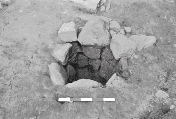
Figure 13.17: Ballista balls filling partition slot G04:31 in Building 4 contubernium 2
At the southern end of the Contubernium 6 a 2.00m length of the slot for the east wall (J04:27) was uncovered giving the chamber a total width of 3.40m. This appeared as a smear of pink and yellow clay 0.15m wide. It was not excavated.
(For internal slot J04:31, uncovered c. 1.10m from west wall and 2.10m from the east wall of the contubernium and perhaps associated with an earlier barrack, see Chapter 12.)
Fragments of a flagstone surface (J04:23a) survived over parts of the room, especially at the north end, probably near the entrance. Again insufficient time meant the flooring could not be thoroughly investigated, but it could easily have represented more than one phase. All of the flagging on the east side of the room appeared to respect the estimated line of the east partition, projected from the length of exposed slot J04:27, apart from one small area midway along the slot’s projected course. The flags consisted of large pieces of stone up to 0.75m × 0.60m × 0.08m thick. The floor over the northern part of the room was similar to the type of flagged surfaces encountered in much the same position, presumably near the entrances, of the contubernia of Building 1 in sub-phase 2.
Only 0.70m of the southern end of the slot (J04:28) between Contubernia 7 and 8 was uncovered. The contubernium measured 3.20m wide. It consisted of a line, 0.20m wide, of grit in grey clay with flecks of orange and grey soil.
There were only two small areas of flagging, one of them (J04:23a) to the west side, already noted, lying over the line of the west partition of the room. The other (J04:23b) occurred over the north of the room and was made up of small unconnected fragments.
The division between Contubernia 8 and 9 was not very clear. An area of a possible slot (J04:26) was revealed for 0.90m immediately north of the south wall foundation. This was not excavated and appeared only as a line, 0.25m wide, of amphora fragments and stone, possibly packing material.
(For slots J04:29 and J04:32 uncovered in anomalous positions in the interior of this contubernium and possibly associated with a preceding timber barrack see Chapter 12.).
Several small pieces of flagging (J04:23c) were found over the north-west corner of the room. These respected the estimated line of the west wall partition.
Using partition slot J04:26 as the west wall of the room, Contubernium 9 measured 3.80m wide. A north–south slot (K04:25), located some 2.00m from the east wall of the building, may have been associated with an earlier timber barrack block rather representing an internal dividing partition in this stone barrack contubernium (see Chapter 12).
In the surface of the levelling material (K04:20) over this area of the building were seven ballista (SF 942a, b, c, 943, 944a, b, c). These may have been part of the surface with the flagged floor K04:21.
Overlying the levelling material and the line of the earler internal partition K04:25 in the northern half of the contubernium was the remains of a flagged floor (K04:21). The larger fragments of flagging measured up to 0.70m long. Roughly in the centre of the room and on the same level as the flagging, was a squared brick and stone alignment 0.55m across, probably the remains of a hearth. This feature was located just far enough north to indicate it probably lay in the front room of the contubernium, perhaps set right up against the partition separating the two rooms. In the southern part of the contubernium an irregular patch of pink clay (J04:30), measuring roughly 0.80m by 1.30m, was revealed next to the west partition wall (J04:26) and perhaps represented the fragmentary remains of a floor surface.
CONTUBERNIA 4–7
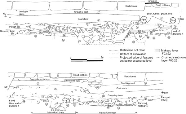
A gulley (H04:06, 26, J04:18) was traced in the area of Contubernia 4–7 alongside the inner face of the building’s south wall. It was packed with rounded stones and pebbles, and extended over a distance of at least 8.50m, being cut away to the east by a north–south aligned band of post-Roman disturbance interpreted as a colliery era trackway (J04:13), so its full length could not be gauged. The gulley’s width varied considerably, reaching as much as 0.90m in Contubernium 6, but was generally around 0.50–0.60m and narrowed to some 0.40m to the west, in Contubernium 5 before petering out altogether just inside Contubernium 4. The feature was interpreted as a drain, similar to the internal drain which ran alongside the south wall of Building 1 during its third-century stable phase. This interpretation is not without its problems, however, and it is evaluated in greater detail below (p 000), along with the other suggested evidence for the third phase of Building 4.
The officer’s quarters were separated from the other rooms in the barracks by a stone partition (G04:14), 0.65m wide. Internally the quarters measured 11.00m in length (E-W). Only the southern 2.10 m of the wall could be uncovered. It consisted, at its highest, of two or three courses of keyed stones, some of which had been removed by the insertion of a modern drain. The rubble core was composed of slightly larger stones than were used in the exterior walls of the building, measuring up to 0.15m long. The wall sat on a foundation of pink puddled clay (G04:33).
At the level of the first course the most southerly facers extended for half their length into the line of the north face of the south wall (G04:11) of the building, bonding the two walls together. The east face of the base course was partly composed of a line of six stones pitched on their sides, possibly evidence of alteration.
As the modern lane ran diagonally across the officer’s quarters, only the north-west corner of the room and a narrow area across the south side were available for examination. The sequence of deposits in each area could not be related to the other, or to those in the contubernia.
A large pit (F03:15), which perhaps functioned as a soakaway, had been dug right through to the natural in the north-east corner of the room during the later occupation of the officer’s quarters. This removed a substantial amount of the stratigraphy in an area already limited by the modern lane and created problems in tracing the true extent of the floors. Most of the following description is taken from the section which lay under the north side of the lane (see Fig 13.18: section S49).
CONSTRUCTION
Cut into the natural (F03:35) were the construction trenches for the north and west walls. The trenches were on average 0.85m wide, just slightly wider than the foundations. The west wall trench (F03:33) appeared to have been backfilled first as the fill of dark grey-brown silt was cut across by slightly lighter fill of the north wall trench (F03:31). Also cut into natural was the north side of a roughly rectangular pit (F03:34). This measured 2.70m east–west and was on the same alignment as the building. The northern lip of the pit slightly impinged on the southern edge of the construction trench and foundation clay for the north wall whilst its western edge was located 0.65m from the west wall trench. The full depth of the pit was not established. It had been backfilled with mixed yellow sand containing yellow and pink clay, grey silt and slight traces of charcoal. Only the first 0.08m of the fill was removed. The purpose of the pit was not ascertained, but it could have functioned as a slurry or clay-puddling pit, or even as a soakaway as it lay in the same position as a soakaway pit (F03:15) from a later period of occupation.
On site plan P72, which recorded the earliest levels excavated in this part of the building, a possible partition slot was shown cutting through the clay foundations of the building’s north wall and the natural clay subsoil some 0.40m to the east of the rectangular pit. The slot was aligned north–south and was c. 0.10m wide. On its east side, a single upright stone (F03:37) perhaps served as a chocking stone.
A deposit of mottled grey and yellow silty clay (F03:25), up to 0.15m deep was laid over the room, covering the former soakaway pit and the construction trenches and foundations of the north and west walls. This was also most likely to have been constructional in purpose, probably representing levelling material. It lay up to the middle of the first course above the offset of the north wall. Cut into this were a succession of gulleys, possibly drainage channels. The earliest (F03:29) lay on a north-west south-east alignment, 1.20m from the inner face of the west wall. It measured 0.17m wide × 0.12m deep and the north end lay 0.03m south of the north wall. The fill consisted of pink clay and grey clayey silt with fragments of stone and charcoal. Another gulley was dug further west (F03:24) on a north-east south-west alignment 2.10m from the west wall. Very little of it could be seen as the later soakaway pit (F03:15) had removed most of the east side. It measured 0.20m wide × 0.06m deep and contained a fill of yellowish-pinkish clay becoming silty towards the north end which occurred just short of the north wall. The third and much deeper gulley (F03:28) lay immediately west of F03:24, on the same alignment and cut both the earlier gulleys. It sloped gently down from the north side, deepening towards the south. It measured 0.35m wide × 0.20 deep and in section the bottom was dish shaped. The fill consisted of fairly homogenous grey clay. The north end had a rounded appearance and lay 0.15m from the inner face of the north wall.
Over the levelling clay right in the north-west corner of the room was a small area of light yellowy-brown clay (F03:30), probably daub from the construction. It lay 0.03m deep against the first course of the north and west walls. The southern edge of the yellowybrown clay was cut by an almost square post hole measuring 0.25m by 0.22m (F03:27). This was filled by a grey- and orange-flecked silt and a single facing stone. The latter was described as ‘beautifully cut with lines and tooling fairly clear’. It was wedged face up in one side of the post hole and presumably served as a packing stone, but it protruded up through through all the surviving overlying floor surfaces so may subsequently have performed some other function.
FIRST FLOOR SURFACE
A slot (F03:26) for a timber partition was dug 3.70m from the west wall. Only 0.35m of the north end was uncovered. It measured 0.15 × 0.10m deep and appeared as a strip of charcoal in a matrix of grey clay overlying bright yellow sand, probably crushed sandstone. This may have been a replacement for the possible earlier slot associated with the single upright stone (F03:37) found 0.10–0.15m to the east.
A compacted surface of small fragments of sandstone (F03:23) were found over the north-west corner of the room, overlying the clay material. This surface did not appear to extend as far east as the later soakaway pit (F03:15), but did cover clay patch F03:30, post hole F03:27 (apart from the protruding packing stone) and slots F03:28 and F03:29. It may represent a localised area of resurfacing.
SECOND FLOOR SURFACE
The whole of the north-west corner of the Quarters was covered with a layer forming either a new surface or, more probably, the makeup layer for a surface. This consisted of a deposit of yellowish-brown clayey silt (F03:22) containing fragments of stone and burnt daub, possibly the remnants of demolition material. It lay up to 0.11m deep, covering the former partition slot (F03:26), the resurfacing of sandstone fragments and the previous clay floor.
A floor surface of scattered small stones (F03:19, 21) was laid over the clayey silt. This surface was not very compacted but the floor did appear to have been deliberately laid. The surface was up to 0.12m deep and the stones measured on average 0.18 × 0.14m. It lay against the top of the first course above the offset of the north wall.
Over this floor was a substantial layer of occupational material (F03:18) up to 0.14m deep. It consisted of dark-grey clay silt, with a slight tinge of green and black and traces of orange and yellow streaking, and also contained a few small stones. The deposit lay up to the middle of the second course above the offset of the north wall. It was covered in turn by a layer of rubble interpreted as demolition debris (F03:10), which also extended northward (as F03:12) over the uppermost surviving intervallum road surface (F03:05). In the F03 site notebook it was suggested that a few small, flat stones (F03:17), covering an area no more than 0.75m square right in the north-west corner, might have been the remnants of a stone floor, overlying occupation layer F03:18. However, it was not sufficiently extensive to appear as a distinct level in section S49 and was considered equally likely to have formed part of the overlying rubble.
THE SOAKAWAY PIT
A bowl shaped soakaway pit (F03:15) was dug through the occupation material and all of the floors and construction material below it to the natural. Only the top 0.60m of the pit was excavated. The area of the pit uncovered measured 1.80m in diameter but this was not the full extent as most of the pit lay under the section side. The west edge was situated 1.20m from the west wall and the north edge was cut immediately south of the north wall. A narrow round ended channel (F03:20) 0.20m wide ran into the pit from the north-west. It sloped down towards the pit where it became deeper, up to 0.25m. The fill consisted of two fairly distinct layers of material. Covering the sides of the pit and filling the channel was 0.13m of dirty-grey silt with a slight tinge of green plus orange or yellow streaks (F03:15.2), probably slippage from the occupational material (F03:18) and representing the period when the pit was open. Above the silt was up to 0.50m of stone and cobbles (F03:15.1), mostly 0.10m to 0.15m in size and fairly close together, but not tightly packed. The interstices were filled with iron-stained dark-grey and black loam. This material was indistinguishable from the demolition rubble (F03:10, 17) which lay over the pit and this part of the site generally, suggesting that the pit was dug while the building was still standing, if not necessarily occupied.
FIRST FLOOR SURFACE
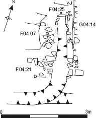
Very little survived of the early floors over the south side of the officer’s quarters. The stratigraphy here had being severely truncated, resulting in the exposure of the pre-fort ground surface of slightly clayey, olive green or grey loam (F04:08) across most of the area. This material was clearly cut by the cultivation furrows which predated the fort as well as later, barrack-period features. Only a relatively small part of this level (distinguished as F04:35), right in the south-east corner of the room, was sealed beneath a flagged floor (F04:07, G04:17), which the excavators interpreted as belonging to a secondary barrack phase. This was not fully investigated due to the shortage of time, but some flags were removed alongside the east wall of the officer’s quarters (G04:14) to investigate the later latrine (F04:25 – see below). Although the underlying material context (F04:35) was recorded as equivalent to F04:08 the latrine site plan (P38) also shows a narrow strip of sandy soil with yellowish patches along the west side of the wall. This may have been equivalent to the 2m wide band of yellow and orange sand and decayed sandstone (G04:35) in Contubernium 1, on the other side of wall G04:14, which was interpreted as a deposit of construction material.
Elsewhere, a tiny patch of the original floor (F04:37) 0.08m deep was found 2.00m from the estimated south-west corner of the building, immediately north of the south wall foundation. It consisted of dirtyyellow clay.
LATER FLOOR SURFACE
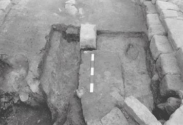
The room was re-surfaced with a flagged floor and a latrine inserted into the south-east corner (Fig. 13.20). The latrine (F04:25) consisted of a box-like structure, located 1.25m from the south wall (F04:21) and immediately west of the officer’s quarters east wall (G04:14), plus a trench running from this, through the south wall and into the eaves drip trench (F04:33) along the centre of the alleyway. Both ‘box’ and trench had been cut through the former clay floor (F04:35). Three upright flags, 0.35m square, formed the east, north and west sides of the box, with the west side collapsed over the fill. Internally it measured 0.40m square. The trench measured 0.30m wide and varied in depth from 0.25m at the north end where it left the box to 0.40m immediately north of the south wall. Small stones were used to form the bottom but the sides do not appear to have been lined. Where the trench cut through the south wall it was considerably wider, measuring up to 0.55m at the point where it left the south wall and entered the alleyway between Buildings 4 and 5. The trench turns south-west to enter the eaves-drip which was obviously re-dug in the direction of the flow to the west of this. Here it was 0.34m deeper than the eaves drip to the east. The fill of the latrine consisted of grey gritty soil containing flagstones and several dressed stone blocks. This suggests that the latrine was probably still functioning until the end of the building when the flagged floor and the east wall of the officer’s quarters collapsed into it.
The floor consisted of substantial, well laid flags (F04:07, G04:17) up to 0.75m × 0.60m in size and on average 0.07m thick. One of the flags still lay over the latrine trench immediately south of the stone box. The top of the box was roughly level with the bottom of the flags. Several flags had collapsed into the southern end of the latrine.
No drains were uncovered north or east of the building. The north end of the drain (E03:10) immediately west of Building 4 was uncovered for 2.50m before it disappeared under the modern lane, being exposed in a small trench cut across the west intervallum road next to the north-west corner of the building. It was composed of three courses of neatly dressed sandstone blocks of various size, but on the whole they were slightly larger than those used for the walls of the building. The channel measured 0.40m wide × 0.40m deep. There was no reason to assume that this was not the full original size and the level of the corresponding street (E03:09) suggested it was intact except for the covering slabs. The street surface sat directly over the pre-fort ground level of grey clay silt (E03:15) and a cultivation furrow (E03:16). The metalling contained some large cobbles and stones and had a brown-red colouration overall. It was wellpacked and noticeably worn. At the very north end on the western side, the drain subsided dramatically into an underlying feature. There was not sufficient time to investigate this. There were foundation trenches (E03:11) for both sides of the channel. That for the east side was much more substantial, measuring up to 0.30m at the widest point. The fill was a mixture of yellow and pink clay and small stones. On the bottom of the drain were deposits (E03:12) of light green silt and of orangey gravel, the latter being left in situ.
Figure 13.18: Section drawing S49 (E), across NW corner of Building 4 (grid square F03) and Section S49 (W) across the intervallum road and rampart (grid square E03) at 1:25.
Figure 13.19: The north-west corner of Building 4 showing: 1. The earliest features cut into natural clay subsoil F03:35, including cultivation furrow F03:32; 2. Features cut into clay leveling deposit F03:25, at 1:75
Between the foundation trench for the drain and the west wall of Building 4 was a gap 0.33m wide covered with greenish silt (E03:14).
Curving around the north-west corner of Building 4 was a gulley (E03:13) 0.35m wide which entered the east side of the west drain at the level of the top course where two stones had been removed. Apparently this was a drainage channel, probably for directing water from the roof into the drain.
During Period 2 of the Fort, while Building 4 was still functioning, the drain was abandoned, parts of it demolished and the channel packed with the side stones. The new west-intervallum road surface (E03:08) was laid over the top of this. This consisted of small to medium-sized cobbles, not as well packed as the earlier street surface and showing only a moderate amount of wear. The metalling was c. 0.10m thick and the carriageway was 3.10m wide.
FINDS
Decorated samian: 125–145 (no. D71, H04:07)
Samian stamp: 75–100 (no. S103, H04:07)
Amphora stamp: middle second century (no. 5, G04:07)
Graffito: (no. 67, G04:07)
Copper alloy: enamelled mount (no. 223, J04:25), loop (no. 343, G04:07)
Stone: throwing stones (nos 7, 18, 19, 23, all flagging K04:21)
Copper alloy: loop (no. 348, F03:22)
Architectural stone: flagstone with image of figure (no. 4, F04:07)
Iron: paring chisel (no. 24, F04:25)
For F04:33 see under Alley 3
Stone: throwing stone (no. 57, J04:18)
The construction trench for the north wall (F03:31) contained 0.119kg of coarse wares, all but 0.003kg of which was BB2 or allied fabrics. There were two sherds of samian, one of which was Hadrianic or Antonine, and the other one Antonine. The foundations of the south wall (G04:05) contained a single sherd from a late Antonine Form 45(?).
G04:07 contained an amphora stamp dated to the middle of the second century (no. 5). The make up layers (H04:07, J04:25) in general contained pottery which could be mid-second in date, with only a few later pieces, such as a sherd of Nene Valley ware and one from a BB2 cooking pot. The six sherds of samian included three of Hadrianic or Antonine date.
The ground surface (F04:08) under the south-east corner of the officer’s quarters produced only two pieces of pottery, one of which was a sherd of a BB2 bowl or dish (but see also F04:35 below). The compacted sandstone surface (F03:23), overlying the silty clay levelling deposit (F03:25) in the north-west corner of the officer’s quarters, contained more BB2, but the overall quantity was small.
The partitions associated with Contubernia 2 and 3 (G04:31, H04:12) produced only two sherds of residual pottery, the flange of a Trajanic-Hadrianic local mortarium and a sherd of Trajanic or early Hadrian samian.
The anomalously positioned north–south slot in the centre of Contubernium 9 (K04:25) contained the greater part of a decorated Form 37 Central Gaulish samian bowl (D90), dated to c. 125–140, which had been repaired with lead rivets, and a sherd from a second possibly Antonine, Form 37.
The flagged floor in the south-east corner produced only two sherds of BB1 and one sherd of an Antonine Form 37 samian bowl (F04:07). The BB1 joins sherds in the latrine (F04:25), which also included some BB2 and a sherd of a Hadrianic or Antonine Ebor red-painted bowl. However the clayey loam (F04:35) sealed beneath the flags – equivalent to F04:08 elsewhere in the south-east corner (see above – Phase 1 officer’s quarters) – yielded sherds from at least four BB2 vessels, including rounded-rimmed bowls or dishes.
The clayey-silt makeup (?) deposit (F03:22) overlying the earlier compacted sandstone floor surface (F03:23) in the north-west corner of the officer’s quarters contained a higher proportion of BB2, but the overall quantity was small. The final layer of occupational material (F03:18) in the northwest corner yielded almost exclusively BB2 and allied fabrics, with only a few sherds of other pottery.
The rubble and loam fill (H04:06, J04:18) of the drain or gully (H04:26) along the inside of the south wall produced only a few sherds of pottery, most of which was BB2.
The soakaway (F03:15) in the north-west corner of the officer’s quarters contained a sherd of Nene Valley ware, and a body sherd of late third- or fourthcentury Crambeck mortarium, which is presumably contamination.
The dating evidence from Building 4, outlined above, is rather contradictory and the picture is further complicated by the possibility that some of the features might conceivably have belonged to a timber barrack preceding the stone one, as discussed in Chapter 12. The material from the wall foundations contained a high proportion of BB2 and allied fabrics which would normally imply a thirdcentury date, and is unlikely to be earlier than late second-century. The bulk of this material derived from a single context – the construction trench for the north wall of the officer’s quarters (F03:31). This trench was clearly overlain by the levelling deposits, makeup and floor levels in the north-west corner of the building, implying that all the Roman activity recognised in that part of the building must have been later in date. If the pottery in the construction trench does accurately reflect the date when the stone barrack was first erected this would imply the building was only occupied for a relatively short period since the three barracks in the west praetentura appear to have been replaced by two new blocks, which occupied different footprints, probably at some stage in the first half of the third century. However, the pottery from other Building 4 Phase 1 deposits and features points to the barrack being constructed significantly earlier. Thus the material in the greyish clay makeup deposits covering the interior of the contubernia would be consistent with a mid-second-century date, with only single possibly intrusive sherds of BB2 and third-century Nene Valley ware, whilst the few vessels associated with the various early partitions could even form a Hadrianic assemblage, although the fact that these partitions apparently cut the makeup deposits ought to signify that this pottery was residual.
The contradictory dates of these assemblages can be reconciled if the pottery attributed to the trench is interpreted as intrusive material, found at the interface between the trench and the much later soakaway pit (F03:15), which certainly cut into the construction trench. The F03:31 assemblage would then reflect the date when the pit was dug or perhaps when the final occupation layer was deposited, rather than when the backfilling of the construction trench occurred. It is noteworthy that the final occupation material (F03:18) in the north-west corner, which also spilled down the sides of the pit, yielded a pottery assemblage which was very similar to that from the construction trench, being composed almost exclusively BB2 and allied fabrics, with only a few other sherds.
Figure 13.20: Plan of latrine F04:25 in the south-east corner of the Building 4 officer’s quarters. Scale 1:75.
The only other pottery associated with the external walls – the single sherd of late Antonine samian from the south wall foundations (G04:05) – is not sufficient on its own to date the construction of Building 4 and might conceivably also be intrusive since the clay foundation deposits were exposed only where the overlying wall masonry had been robbed out. This would mean the most reliable date for the initial construction of the building would be that provided by the contubernia makeup soil (G04:07, H04:07, J04:25, K04:20). The records in the site notebooks suggest this was a complex deposit. It was not fully investigated or removed, although small sondages were dug into it in places to try to expose partition slots in section. Deposits G04:07 and J04:25 were said to be cut by the foundation trenches for the south wall (G04:05, J04:21), which would imply it was laid before the walls were constructed, whilst K04:20 on the other hand was recorded as abutting the external walls (K04:11, 16, 17) and in the context entry for J04:25 it was noted that ‘some of 25 must in fact overlie 21’, but this appears to have been a deductive inference rather than a direct observation.
Building 4 contained two late features the function of which was not clearly apparent within the context of a barrack block. In the north-west corner of the officer’s quarters a bowl-shaped pit (F03:15), with associated narrow channel (F03:20), was tentatively interpreted as a soakaway. A stone-packed gulley (H04:06, 26, J04:18) was also traced in the area of Contubernia 4–7, extending for at least 8.50m along the inner face of the building’s south wall. To the east this feature was cut by extensive post-Roman disturbance, so its full length could not be gauged, but to the west the gulley simply petered out just inside Contubernium 4. This gulley it was tentatively interpreted as a drain, perhaps comparable with the internal drain alongside the south wall of Stable Building 1, since it extended through several contubernia and did not respect the limits of any individual contubernium. The possibility that the gulley and soakaway might together constitute a distinct, third phase of building 4 was hinted at in the research archive, but no clear interpretation of the building’s function in that putative phase was offered. It is clear, however, that H04:06/26/J04:18 could not have functioned in conjunction with the central contubernia if it did represent a drain.
One possible explanation is that the block was converted into a stable, like Building 1. This might conceivably have been a relatively short-lived episode towards the end of the life of Building 4, providing stable accommodation in this part of the fort, perhaps directly preceding the reconstruction of Building 1 as a fully functioning stable in the third century, at which point 4 presumably became redundant and was demolished along with Buildings 5 and 6 to be replaced by two new barrack blocks. The spreads of flagging in Contubernia 5 and 6 (H04:09c, J04:23a), which apparently overlay the partitions separating Contubernia 5, 6 and 7, could conceivably have formed the floor of the converted building, although there was no other intrinsic difference between this flagging and that assigned to the Phase 2 contubernia to the east and west (e.g. H04:09a-b, J04:23b-c). The suggested soakaway pit might likewise have potentially played some role in a stable.
On balance, however, the evidence regarding these features was too uncertain for this hypothesis to be treated with anything other than the greatest caution. Gulley H04:06/26/J04:18 was not altogether convincing as a drain. It did not appear to run the full length of building, instead petering out in Contubernium 4. Nor was there any indication of a drain outlet either passing through the east wall of the building (as was noted in the case of Building 1) or through the wall separating the contubernia and officer’s quarters, and there was no trace of stone lining along the north side of the feature at any point along its length, again in direct contrast to the drain in Building 1. Indeed the gulley could be a much later feature. It was cut down from mixed loamy rubble spread (H04:19, J04:05) overlying the building interior, which represented the disturbance at the interface between the surviving stratified Roman levels and the heavy clay post-Roman ploughsoil (H04:01.3, J04:03) directly above. The rubble disturbance was recorded as overlying the gulley’s fill, but the latter was evidently very similar in its composition, though stated to be more closely packed, and it is not clear that the two should really be distinguished, that is to say H04:06/26/J04:18 might simply represent that part of H04:19/J04:05 which filled the gulley-like depression along the inner face of the south wall. It might simply represent a later intrusion, of indeterminate function, into the Building 4 levels. Similarly the so-called soakaway pit might in fact have been a clay quarry pit, cut into the northwest corner of 4 after the latter had been abandoned, with the aim of providing bonding material for the pair of third-century barracks to the south. In this case the suggested third phase of the stone building could be discarded altogether.
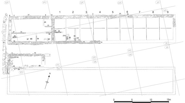
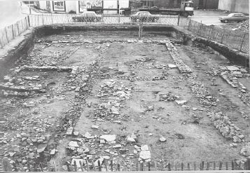
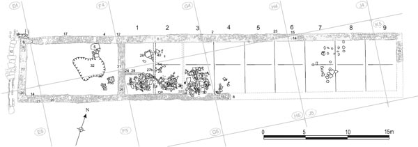
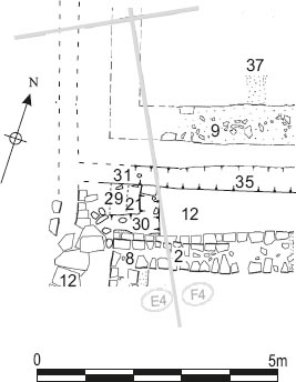
Grid squares: E4, E5, F4, F5, G4, G5, H4, H5, J5, K5
Much of the contubernium area of Building 5 had been completely destroyed by a colliery trackway which passed across the structure from north-west to southeast. Nevertheless a structural sequence not dissimilar to that of Building 4 could be established, with the contubernia being floored with stone flags in Phase 2. Some of these flags were obvious, others looked reused and random. The end of Phase 2 was marked by the demolition of the barrack and its replacement by a somewhat larger barrack block (17) with stone-walled internal partitions. This occupied a more northerly footprint than Building 5 and incorporated the north wall of the earlier barrack as its medial wall.
The overall external measurements of the building were 44.9m by 7.5m, fragments of the wall surviving in places on the northern side and in the north-east and north-west corners. An offset of 0.15m was employed, most noticeably at the north-west corner. Elsewhere, the line of the wall could be followed with the help of the clay foundations. The wall varied between 0.55m and 0.75m in width where it survived, and was constructed of sandstone blocks with a rubble core. It was founded upon grey clay containing pitched stones (at about 45 degrees).
The north wall was 0.65m wide at the western end (E04:08) with an offset to the north. It was constructed on pitched (from west to east) stone foundations 0.8m wide set in grey clay (F04:17). The wall itself only survived in the north-east (2.75m) and northwest (2m) corners of the officer’s quarters, and at the north-eastern end of the building (K05:23 – 5.5m).
The south wall was the most poorly preserved of all the main exterior walls of Building 5, with only foundations present for most of its excavated length. Near the south-west corner, four stones (E05:14) of the inner (northern) face of the wall were found, but elsewhere there were only the grey clay and stone foundations (E05:23, F05:20, G05:21, G05:10, H05:08), c.0.9m wide. Some but by no means all of the stone in these foundations was pitched (from east to west).
The northernmost 2.5m of the east wall (K05:19) survived, but the remainder had been robbed away. The west wall (E04:09) was only preserved at the north-western corner of the building. It was 0.65m wide and the surviving section only 1.5m long from the corner of the structure. The wall was set on the western side of its 1m wide grey clay and stone foundations (E04:22), even projecting beyond them in places.
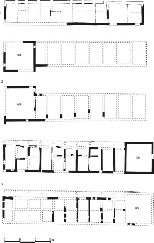
The barrack can be restored as having a total of nine contubernia, mirroring Building 4, as might be expected. Again, the contubernia were delineated by timber partitions, surviving as slots, whilst the officer’s quarters were demarcated by a stone wall.
All of the contubernia measured 6m internally from front to rear, with a distance of 3m to 3.5m between the main north–south oriented partitions. The east– west oriented partition in Contubernium 1 suggests that the internal dimensions of the arma and papilio were 2.25m × 3–3.5m and 3m × 3–3.5m respectively.
PHASE 1
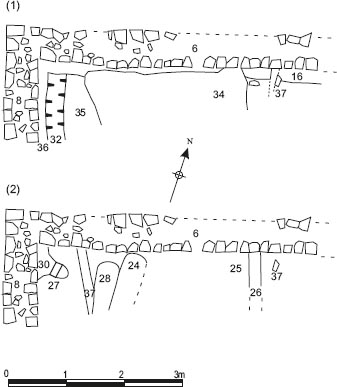
Only the north–south slot (G05:27a) survives from the first phase of this part of the building and this was 0.4m wide, 0.1m deep, and traced for a length of 1.75m.
PHASE 2
In this second phase, a replacement north–south partition (G05:27b) was identified, slightly to the east of the primary example, The north–south partition was 0.23m wide, 0.15m deep, but could only be followed for 1.75m. An east–west slot (G05:29) was also identified and attributed to this phase by the excavators. It was mainly defined as a line of stone on the surface (and did not show up clearly in section), and survived for 1.75m of its probable 3m length. It should, however, be noted that this slot continued the same line as the Phase 1 partition in the officer’s quarters immediately to the west (see Chapter 12 for further discussion of the potential significance of this slot relation to the evidence for a timber barrack block).
A floor surface (G05:11a) was also identified within the contubernium to the south of the east–west partition, consisting of irregular building stone and small flags. This was overlain by a patch of charcoal, grey soil and upright stones (G05:26), which may have filled a depression or a cut through the stone floor, but the record is not clear.
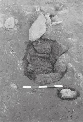
In the north-east part of the contubernium a subcircular stone-lined cist or box (G04:28) was revealed, set into the floor against the secondary north–south partition. It measured 0.60m in diameter, internally, and was 0.30m deep, being filled by dark grey soil containing charcoal and many small stones overlying a shallower layer of light grey-green sticky soil. The stones lining the pit were upright or pitched at a sloping angle. Its function and even its attribution to the Roman period is uncertain (see below for further discussion).
PHASE 1
A short length of the north–south partition between Contubernia 2 and 3 (G05:32) was found and this was 0.7m wide. Upright stones positioned adjacent to the partition marked the location of a hearth (G05:31), which was associated with patches of burnt clay and coal (G05:35). A second north–south partition slot (G05:34) was located 1.15m west of that separating Contubernium 2 from 3. This may have screened off an entrance corridor leading from a doorway positioned in the south wall to the east side of the contubernium facade, following the common pattern, recognised at neighbouring South Shields, for example (cf. Hodgson and Bidwell 2004, 137–9 for discussion of these features).
PHASE 2
A similar surface (G05:11b) to that found in Contubernium 1 was identified and a further section of flagging (G04:40) was noted in the north-west corner of the contubernium. Another stone-lined box (G05:25), also of uncertain function and date, was set into the floor in this contubernium. The cist was oval in plan, measuring 0.60m × 0.80m, with a maximum depth of c. 0.30m, and contained fill deposits similar to those in G04:28 – a medium-dark grey soil over a thin layer of grey-green clayey soil which was streaked with yellow clay and lined the bottom and sides of the box. It was situated on the west side of the contubernium, roughly midway between the north and south walls.
A similar surface to that noted in Contubernia 1 and 2 was found in this contubernium (G05:11c). This probably belonged to the second phase of this building. It overlay a spread of charcoal (G05:23) and a depression (G05:30) cut into the natural.
Within Contubernium 4, a pocket of small flags (H05:07) 1.0m by 0.5m were all that remained of the flooring within this area. This likewise probably belonged to the second phase of this building.
Sandstone flagging (J05:27) occurred in patches within the area of this contubernium which may represent the second phase of flooring within the building. There are hints of an underlying stone surface (J05:23) which may be the first floor. A pivot stone was noted amongst flagging J05:27 and may have been in situ since it was located midway between the north and south walls of the contubernium only c. 0.80m from the estimated position of its west partition wall. The pivot was perhaps associated with a doorway in the medial partition between the north and south rooms located in the usual position over to one side of the contubernium.
The date and function of the two stone-lined boxes or pits uncovered in Contubernia 1 and 2 was uncertain. Various comments in the site notebooks suggest the excavators were divided as to whether these were Roman or colliery period features, with the latter viewpoint perhaps gaining most support. Similar features, which were clearly Roman in date, but much more rectangular and box-like in form, were discovered in Contubernia 4 and 8 of Building XIII at Housesteads (see Rushworth 2009, 86–9). On the other hand, a demonstrably recent parallel can be found at Wallsend itself, in the shape of L05:21, a stonelined pit set in a larger oblong pit (L05:27) towards the western end of Building 2. This was probably nineteenth-century in date, the larger pit having been floored with a wooden plank and probably lined with pantiles before being reduced in size and lined with stone. The fills contained much pantile, plus wood, clay pipe fragments and post-medieval pottery. No obviously modern material of this kind was recorded in the fills of G04:28 and G05:25, however. Indeed the Roman pottery assemblages in the fill deposits – particularly that from G04:28 which produced a fair quantity of material – appear to be coherent late second/third-century groups which could perhaps reflect backfilling of the pits when Barrack 5 was demolished, along with 4 and 6, in the earlier part of the third century. However their composition might also be compatible with the occupation of Building 17, one of the Period 3 barracks which replaced Building 5.
If the character of the pit fills is convincing with regard to a Roman date, the positioning of the oval boxes raises more serious reservations. They were located only 1.20m apart on either side of the partition slot separating Contubernia 1 and 2 (G05:27). Indeed G04:28 would appear to impinge on the line of one phase of the slot, though perhaps not the other phase. Moreover the two boxes did not occupy directly corresponding positions within the contubernia. Whereas G04:28 can only have been situated the rear room of Contubernium 1, G05:25 was located further south and could conceivably have lain in the front room of Contubernium 2, notwithstanding the uncertainty regarding the positioning of the partition separating the two rooms here. The close proximity of the stone-lined boxes, their apparent lack of correspondance with regard to the likely internal arrangements of Contubernia 1 and 2, plus the absence of equivalent features from any other contubernia supports, though it does not prove, the idea that these may have been later features, which either belonged to the subsequent Period 3 barracks or were post-Roman in date and intruded down into the Roman levels. Certainly the boxes cut down from the very top of the sequence of stratified Roman levels – albeit a sequence that was severely truncated – and were reportedly overlain only by an extensive spread of disturbed rubble (G04:16, G05:17), forming the interface of disturbance at the bottom of the post-Roman plough soil. Moreover comments in the site notebooks make it clear that the excavators were not even sure whether the boxes actually underlay the rubble level – which they believed formed the disturbed remnants of a late Roman cobbled surface – or cut through it as well, adding yet further uncertainty to the interpretation and dating of these features.
The officer’s quarters were separated from Contubernium 1 by a north–south stone partition. The wall itself did not survive, but the foundations of light grey clay and pitched stone (F04:31, G04:27, F05:26, G05:24) remained. This was about 0.85m wide and produced an internal area of 6m by 10.75m for the officer’s quarters.
Two rooms were defined to the south by an east– west timber partition, indicated by a slot (E04:27, F04:37, F05:59), c.0.30m wide, filled with clay and sand, together with a north–south slot (F05:58) 0.30m wide. Together, the two rooms thus formed measured 6.5m × 2m (south-west room) and 4m × 2m (southeast room). Another east–west partition slot (E04:25), which was situated 0.70m south of and parallel to slot E04:27, may have defined a narrow corridor leading to a doorway in the west wall of the building. Only 1.20m of this second slot were traced. In the northeast corner of the officer’s quarters, a small room, measuring 2m × 1.9m, was apparently partitioned off by two further slots running north–south (F04:45) and east–west (F04:28).
A 0.02–0.03m thick spread of pink clay (E04:20, F04:24), containing patches of mortar, daub and charcoal, covered an area extending some 3m (E-W) by 2m (N-S) in the north-west corner of the officer’s quarters. The excavators suggested this layer represented daub resulting from the demolition of the building at the end of Phase 2. However the clay was described as puddled and the description appears more consistent with a clay floor level or a makeup layer. It directly overlay the grey clayey loam (E04:26, E05:26, F04:22, F05:31, G04:20, G05:23) which formed the pre-fort ploughsoil.
The main feature attributed by the excavators to the second phase of the officer’s quarters was a large, irregularly-shaped, sub-oval pit (F04:32, F05:36), which was interpreted as a latrine. Staining of the natural was noted. The pit was 0.4m deep and 3m (north–south) by c.3.5m (east–west). The fill included small stones, charcoal, and coal. A channel (F04:05) c.0.6m wide by 0.2m and covered by three flagstones appeared to lead southwards (and downhill) into the pit from the eavesdrip between Buildings 4 and 5, although logically this would make more sense as a drain from the pit into the external east–west channel
The internal flooring of this phase is represented by a patch of flagging (F05:60) measuring 1m by 0.75m. The function of a large stone block (F05:56), 0.25m square and pierced by a 10cm hole, which overlay the surface is unclear.
The irregularly-shaped pit in the officer’s quarters (F04:32/F05:36) is a puzzling feature for which it is difficult to provide a satisfactory explanation. It was initially regarded as a latrine pit and then as a water storage feature, as it was noted that the bottom of the pit was well below the level of the channel (F04:05) leading to it from the north, which ought therefore to represent a conduit supplying water to the pit rather than a drain discharging effluent from it. However, the large size of the pit and its highly irregular form combined with the lack of evidence for any kind of lining seem to militate against either interpretation. In its extant form it would have taken up a substantial portion of the officer’s house and, because of its irregular shape, would appear to have rendered an even larger area unusable. It is conceivable that the pit was originally more regular and perhaps slightly smaller, with its final shape being a result of robbing which had removed all trace of a stone lining, but if so the robbers displayed unusual thoroughness in removing all traces of the stone revetting.
Such difficulties would be resolved if the two components – the pit and the channel – are divorced from one another and no longer regarded as part of a same structural feature. Channel F04:05 occupied a position broadly corresponding to that of the box-like latrine in the south-east corner of Building 4, which was clearly not associated with a pit, and it may likewise have represented a latrine feeding into the gulley in the alley between the two buildings. The channel clearly extended as far as the pit but that need not mean that the two were associated. The southern end of the channel could merely have been clipped or truncated by the pit at a later stage, after the latrine had gone out of use, giving the excavators the false impression that the two were connected. The irregular pit may simply have served as a quarry, providing clay for the construction of the buildings which replaced Barracks 4, 5 and 6 in this part of the fort, and might be analogous to pit F03:15 in the north-west corner of Building 4, which was similarly one of the latest features in the stratigraphic sequence there, potentially postdating the life of the building itself. After digging the pit may conceivably have lain open for some time and collected water (giving rise to the staining of the natural and the slight undercutting of the lips of the pit noted by the excavators) before backfilling to allow construction of Building 17 over the top.
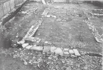
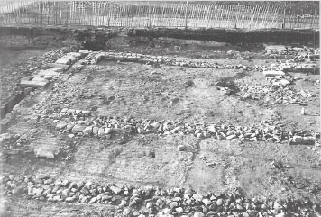
Figure 13.22: 1975 excavation Site 2 looking west mainly showing the west end of Building 5 – foundations and wall footings of Stone Phase 1 (Period 2). Fragments of the thirdcentury barrack phase can be seen surviving over the former street to the south (left).
Figure 13.23: West end of Building 5 with the stone-capped intervallum street drain in the foreground and the north-west corner of the building visible behind.
FINDS
Decorated samian: 125–145 (no. D6, F05:31)
Iron: spearhead (no. 4, G04:20), bell (no. 38, G04:20)
Lead: sheet (no. 18, G05:23)
Bone: pierced (no. 56, G05:23)
Quern: (no. 47, G05:23)
Stone: whetstone (no. 22, E04:23)
Iron: lift key (no. 29, E04:25)
Copper alloy: brooch (no. 9, E05:22)
Copper alloy: pin (no. 118, E05:38)
Bone: bobbin (no. 33, E05:38)
Decorated samian: 150–80 (no. D55, G05:25)
The largest group of pottery, from the foundations of the north wall (G04:08), was contaminated with post-medieval material. The foundations of the south wall (G05:10, 21) produced ten sherds of samian, but only one small scrap of coarse ware. There were two Form 33s, a Form 31, a bowl and a scrap all dating to the Antonine period.
The north wall (F04:02) was contaminated with later material, including a late fourth-century Huntclifftype rim.
The covered section (E05:38) of intervallum drain E05:05 produced sherds of BB2, a sherd from an Antonine Form 37, and one sherd of black sand amphora of the second half of the third century. The uncovered section produced only a few sherds of a flagon (E05:39).
Pottery from the slot in the officer’s quarters (E04:25) consisted of one sherd of BB1, one sherd of locally produced grey ware and a sherd from a Hadrianic or Antonine Form 33 samian cup. The partition between Contubernia 1 and 2 (G05:27) produced two sherds of locally produced grey ware and the depression in Contubernium 3 (G05:30) a few sherds of locally produced grey ware.
The pink clay spread in the north-west corner of the officer’s quarters (E04:20) produced only a few sherds of BB1 and locally produced oxidised ware.
The large pit in the officer’s quarters contained only a scrap and a sherd of repaired, locally produced grey ware (F04:32),
The stone-lined cist in Contubernium 1 produced a fair quantity of pottery (0.882kg excluding samian), 90% of which was BB2 and allied fabrics, including three Gillam 151 rims dating to the third century (G04:28). There was a single sherd of samian, from a Curle 21 dating from the late second or first half of the third century. The cist in Contubernium 2 produced only a body sherd of BB2 and two sherds from a Form 30 dated 150–80 (G05:25). These assemblages may reflect the backfilling of the stone boxes, perhaps at the end of the barrack’s life.
Grid squares: E5, F5
Most of Building 6 lies beneath Buddle Street so that only a very small part of this building – its North-West corner – could be excavated in 1975. As a result little can be said regarding the function and phasing of this structure, though it may be presumed to represent another barrack block like Building 3 which lay in the corresponding position on the east side of the via praetoria. The building was probably demolished at the same time as the other barracks in the western half of the praetentura, perhaps during Fort Period 3 or at the beginning of Period 4.
At the west end of the building a series of wall foundations consisting of clay and cobbles projected northwards 3.90m onto the area of the street. Varying in width from 0.80m–0.85m, these comprised a west foundation (E05:40) corresponding to the western end of the building, a north foundation (E05:11, F05:12), which ran 10.10m eastwards to join up with another north–south aligned foundation trench (F05:57). There was no trace of the north foundation to the east of E05:57, giving the assemblage the appearance of a wing, projecting north of Building 6. The foundations were clearly overlain by the lower (E05:12) of the two metalled surfaces covering the street between Buildings 5 and 6 (Alley 4) and must therefore be early in the life of the fort.
Figure 13.27: The unfinished foundation of Building 6 in the foreground with Barrack 5 beyond, looking north.
These redundant foundation trenches presumably represent a scheme for the block or the officer’s quarters at any rate, which preceded the stone barrack ultimately constructed further to the south. Their precise significance is unclear however. On the one hand their existence may indicate that Building 6 was originally intended to occupy a more northerly position and, by implication, that the disposition of the other buildings in the praetentura, as initially planned, differed from that finally realised. The corresponding area of the eastern praetentura is covered by Buddle Street so it is unclear as to whether this layout was replicated on that side of the fort as well. The foundations may have been constructed to support a stone-walled officer’s quarters associated with a range of timber contubernia, either as part of the primary layout of a predominantly timber block or a secondary partial rebuild in stone. However, no timber beam slots for the remainder of the block were actually identified to the east of the foundations. On the other hand it does not seem very likely that the foundations can be explained as part of an initial L-shaped barrack plan which entailed the officer’s quarters projecting forward of the contubernia and the line of the officer’s quarters north wall being continued by a colonnade along the front of the contubernia. This type of barrack is found at forts elsewhere on Hadrian’s Wall, such as Housesteads, Chesters and Benwell, but in this case would have resulted in a very deep colonnaded veranda, at 3.90m roughly twice the width of those at Housesteads for example. Whatever the precise form of the intended building, there is no indication that any walls were ever erected on the foundations, suggesting that the scheme was probably abandoned before completion.
As finally constructed Building 6 took the form of a straightforward rectangular barrack of similar form to the others at Wallsend. The north wall of the building had largely been removed, all that remained being some medium-sized stones set in pink clay (E05:28). It had evidently been 0.7m in width. The basal course of the west wall (E05:08) survived in better condition than the northern. It was 0.65m wide and a length of 1.6m was excavated. Two stones of the first course survived in situ, slightly smaller than those below. There was an east–west drain or eavesdrip (E05:29, F05:48) c.0.2m wide, immediately north of the line of the north wall and contemporary with the lower street surface (E05:12). This fed into the main covered north–south drain (E05:05) that ran to the west of Buildings 4, 5, and 6. It was subsequently filled with grey soil and stones (E05:34, F05:47), assumed to be a mixture of natural fill and packing.
FINDS
Pottery: counter (no. 89, F05:47 – silt fill of drain F05:48)
The unused west wall foundations (E05:40) held a few sherds of BB2.
The fill of the drain (E05:34, F05:47) contained thirdcentury material, such as a sherd from a Nene Valley ware beaker and BB2 and allied fabrics, as well as sherds from two East Gaulish samian vessels dating to the late second or first half of the third century.
Only a small amount of datable material was recovered from Building 6, as might be expected given the limited area available for investigation. This was sufficient to show that the drain to the north of the building was not taken out of use and filled with packing material before the beginning of the third century. The BB2 in the unused foundations may however have been intruded when that area formed part of the street between Barracks 5 and 6, as the foundations were only very sparsely overlain by surviving cobbling of the secondary street surface (E05:32).
Various stretches of road metalling were exposed around the Period 2 stone barrack blocks in the north-west praetentura. These included parts of the intervallum road, the narrow back alleyway between Buildings 4 and 5, the broader street between Buildings 5 and 6, and the via praetoria.
Only the stretches of the north intervallum road in front of the east end and western half of Building 4, located in grid squares K03 and F03-G03-H03 respectively, were examined. The intervening eastcentral part of the street, extending across much of H03 and virtually the full length of J03, was covered by the modern back lane between the terraced houses of Buddle Street and Winifred Gardens, which was not excavated. Moreover the surfaces uncovered in grid squares G03, H03 and K03 were not exposed right up to the north wall of Building 4, because of the limits of the excavation site, and so the precise relationship between the barrack and the successive road surfaces could not be determined. Furthermore this area was not excavated right down to the natural subsoil and there is therefore no definite guarantee that the lowest layer of metalling exposed was indeed the primary road surface. There was also a degree of apparent confusion in the recording of equivalences between the road surfaces in G03 and H03, with some contexts being described in such an identical manner as to suggest that they represented the very same level, but these did not match the reported equivalences. Consequently, the correlation of road levels in the two areas investigated is somewhat hypothetical.
The earliest layer identified towards the west was represented by a gravel surface (G03:16). The exact location of this metalling was not shown on the sketch plans for G03, but its approximate position can be estimated by reference to the subsequent gravel surface, G03:15, which directly overlay G03:16 and is shown on a sketch plan. G03:16 contained less sand and was composed of slightly larger stones than G03:15 and was probably equivalent to H03:10, which was described in exactly the same terms in relation to overlying surface H03:09, despite the fact that H03:10 was listed as equivalent to G03:15. It was also noted that towards the west G03:16 began to resemble the cobbled surface (G03:17) in the entranceway of the north-west interval tower (Tower 1).
To the north-east of Building 4, the earliest level revealed (K03:36) was made of small cobbles. This was revealed next to the south wall of the north gate’s western guardchamber (marked by robber trench K03:32 and a residue of surviving pink foundation clay). As was also the case in G03/H03, excavation was not taken deeper here to find natural subsoil so it is uncertain whether this was indeed the primary road level, as supposed, and the equation of G03:16/ H03:10 and K03:36 is somewhat arbitrary.
The second recorded level of the intervallum road in grid squares G03/H03 was described as a compact surface of sand and gravel (G03:15, H03:09). This reportedly lay at the same level as the cobbled surface in the entrance passageway of the interval tower (G03:17, H03:08), immediately to the north, although the composition of that cobbling was somewhat different, taking the form of a compact spread of small angular stones, 0.05–0.10m in length.
Further to the east, the level of small cobbles K03:36 was succeded by another cobbled surface (K03:11, K03:35). This ran up to a very rough line of five irregularly-shaped flags (K03:34), which extended for about 1m alongside the south wall of the gatetower and appeared to form an edge to the road. The flags each measured c. 0.25m by 0.30m and were c. 0.05m thick. They appeared to sit on two levels, with two set somewhat lower than the other three, but both levels were recorded as abutting and therefore associated with cobbling K03:35 rather than the underlying K03:36.
Covering G03:15 was a further surface composed mainly of medium-sized river-washed cobbles, but incorporating some dressed stones (G03:14). No correspondence with any context in H03 can be established – it was variously stated to be equivalent to H03:09 and H03:10, which however more clearly relate to G03:15 and G03:16 respectively – but it may conceivably have extended into that grid square. G03:14 may have been equivalent to the rubble surface (F03:05) exposed further to the west, next to the north-west corner of Building 4. This was the only road level uncovered in F03, but – in contrast to the all the layers described above – was traced as far as the north wall of the building, where it was seen to overlie the wall’s offset course. It was not, however, recorded as extending further south over the remains of the barrack block. The context was described as a rough cobble surface with some small angular stones and small river-washed cobbles, 0.10–0.15m in length. Fallen building stones were also noted lying on this road level.
No further intervallum road surfaces were noted in the area approaching the north gate. Here the second level (K03:11/35) was overlain by rubble disturbance (K03:21) which also covered the robbed remains of the west guardchamber, implying stratigraphy was considerably truncated here.
The first three levels of the north intervallum road in grid squares G03 and H03 have been assumed to be contemporary with the stone barrack (4) of Periods 2–3 (and perhaps any timber predecessor). However no finds were recorded from any of the levels described above to provide confirmation of this or any indication of the date of each successive surface. Moreover the relationship of the street levels to Building 4 was unclear except at the north-west corner where F03:05 overlay the building’s offset course but did not extend further south over the interior.
Two stretches of the west intervallum road were examined in the praetentura, next to the northwest corner of Building 4 (in grid square E03) and extending from the south-west corner of 4 to the north-west corner of Building 6 (E04-E05).
The pre-fort ground surface was identified in several areas on removal of parts of the intervallum road surfaces. Thus excavation of a narrow strip across the intervallum street in E04 revealed a deposit of very clayey, grey soil (E04:33), some 0.10–0.20m deep, underlying the road levels. This incorporated flecks of iron-panning and most likely formed the remnants of ploughsoil pre-dating the military presence. It might represent the same material as the slightly mottled, grey clay-silt (E03:15) uncovered beneath the earliest road metalling in E03, which was clearly cut by a pre-Roman cultivation furrow (E03:16). E03:15 itself was not removed, but E04:33 was seen to lie directly over the natural subsoil which consisted of orange-pink clay and yellow-orange sand with traces of cross-ploughing marks cut into it.
The pre-fort ground surface was also uncovered in the narrow strip between Buildings 5 and 6 and the intervallum drain, some 0.35–0.40m to the west, where it was described as an olive grey or light green-brown loam with a slightly clayey texture, incorporating flecks of yellow-pink clay and orange-red iron pan, plus coal, charcoal and some small angular stones (E04:23, E05:21). Here too it was cut by a probable cultivation furrow (E05:07).
Beside the north-west corner of Building 4 the earliest street surface consisted of an iron-stained, worn surface of pebbles containing a few large cobbles and stones (E03:09). It was exposed for 2.50m to the west of drain E03:10 which it met on the west side, overlying the foundation trench. Presumably the drain covers would have abutted this surface.
Further south a primary via sagularis surface composed of a mixture of medium-large and very small cobbles (E04:11, E05:06) was also recognised immediately west of Buildings 5 and 6, set on a base of redeposited natural clay, yellow sand and crushed sandstone (E04:13) some 0.05m deep.
A substantial north–south aligned intervallum drain (E03:10, E04:12, E05:05), which ran alongside the west walls of Buildings 5 and 6, seemed to be contemporary with the primary road surfaces described above. The channel was 0.35–0.40m wide and lined either side with walls up to 0.40m high generally composed of three courses of dressed rubble. In E03 these walls were described as neatly-faced with sandstone ashlars (by which squared rubble is usually meant in the site archive), but further south, in E04-E05, they were reportedly very poorly built, with irregular coursing, the stones mostly, but not invariably, worked to a flat face. At the north end of the drain the west side wall was clearly subsiding into some underlying feature which was not investigated. There were also signs of collapse or subsidence in E04-E05. The walls were set in a construction trench (E03:11, E05:22), 1.15–1.20m wide overall. The drain’s western side wall was set right up against the edge of the trench, with very little packing required, whereas there was a gap c. 0.25m wide behind the other wall, which was backfilled with mixed yellow/pink clay, grey soil and many small stones. No cover slabs survived along the 2.50m stretch in E03 but they did survive over three stretches of the drain in E04 and E05, the longest of these (in E05) being some 5.6m in length. The slabs were c. 0.70m wide on average and up to 1m in length, ranging in thickness from 0.05m to 0.11m, and lay flush with the surface of the intervallum street.
In E04 the bottom of the drain was seen to be lined with pink clay (E04:36) which also came up side of the lowest course of stones. The clay didn’t appear to have been puddled and gave the impression of having been spread out, with spade cuts in it. Various silty fills were noted in the bottom of the drain where the capstones were absent, ranging from a light green silt (E03:12) overlying a deposit of orangey gravel in E03 to a medium grey-brown silt and a few small stones (E04:18, E05:37, 39) further south. Where the capstones remained in situ the fill sealed beneath comprised a dark brown clayey loam (E04:34, E05:38) containing much charcoal and small stones, the top being stained a black colour and having a powdery consistency immediately beneath the flagstones, probably as a result of water action, becoming much more silty and a little lighter in colour lower down.
A gulley (E03:13), some 0.35m wide, ran around the north-west corner of Building 4 and connected with E03:10 where there was gap in the side wall with one or two facing stones missing. This contained green-grey silt and small stones. It perhaps formed the end of an eaves drip gutter running along the north side of the barrack and designed to channel runoff flowing from the roof of the building into the drain. No other trace of this gutter was identified further east, but the road levels here were not excavated to a sufficient depth to expose the primary surface and any associated gutter channel.
A short length of drain (E04:30) fed the runoff from the drip trench between Buildings 4 and 5 (and later the latrine in the officer’s quarters of Building 4) into the north–south drain
This stretch of drain beside Building 5 appears to have remained in use right up to the end of the fort’s life.
A new surface (E03:08) was laid over the northern end of the western intervallum street. It was composed of a single layer, 0.10m deep, of small to medium sized cobbles. This surface was not very well packed and showed only a moderate amount of wear. It ran over drain E03:10, which was dismantled and backfilled with rubble, and abutted a newly constructed kerb (E03:07) of the west rampart, which sat on top of the earlier metalling.
No equivalent secondary surface was noted further south in E04 and E05. Here the primary road surface was overlain only by a 0.40–0.60m depth of rubble (E04:07, E05:04), including cobbles facing stones and flagstones, set in a loose matrix of dark grey soil and, lower down, a black clayey soil with much orange/red iron staining. This rubble also filled the intervallum drain channel where the cover slabs were absent.
The road was not excavated to the earliest levels in the area east of Buildings 4 and 5 and only the uppermost layer of cobbling (K04:04, K05:14), immediately below a modern layer, was explored.
Further north, the cobbled surface of this street (K03:12) was located running through the east carriageway of the North Gate. Two surfaces, an upper (L03:48) of well-packed medium-sized cobbles, and a lower gravel surface (L03:50), were noted in the east carriageway. The lower surface seemed to overlie a dark soil layer (L03:51), whilst the upper was seen by the excavators as repairs to the lower. (see Chapter 18 below – North Gate, for full discussion)
The alleyway between the south wall of Building 4 and the north wall of Building 5 was 1.50m wide and was not metalled. A homogenous deposit of grey silty clay (E04:21, F04:12, G04:18a, H04:25, J04:19) up to 0.15m deep lay over the natural ground surface. A drip trench (E04:31, F04:33, G04:18, H04:04), 0.55m wide, ran down the centre of the alley, cutting the grey clay deposit and the natural. Originally it was 0.16m deep with a shallow dish-shaped profile. The fill was similar to the clay through which it was cut, but slightly darker and iron-stained. The trench would have emptied into the drain which ran down the east side of the westintervallum street, but the junction of the two features had been removed by a modern pit (E04:06).
The trench was later re-dug (F04:33) in the direction of the flow west from the point where the channel from the Building 4 officer’s quarters latrine (F04:25) entered it. This measure was presumably associated with the construction of the latrine. The new trench was the same width but 0.50m deep. Alterations were made to the course of the channel at its west end which may also be linked to this recutting. A 0.90m long branch (E04:30) was dug at a right angle to the original course to meet the north wall of Building 5. It then turned sharply again to run around the north-west corner of the barrack to connect with the intervallum drain a little to the south. The rerouted channel thus took the L-shaped dogleg (Figs 13.28, 13.29). The original channel to the west of the new branch may now have gone out of use, but there is no definite evidence.
Two distinct phases of metalled surface (6.2m wide) were identified between Buildings 5 and 6.
The earlier level (E05:12, E05:36, F05:46, G05:07, H05:03) took the form of a very well laid surface mostly made of closely packed small cobbles with a few larger stones, plus the occasional spread of more angular, sandstone rubble fragments (E05:36). This was set directly on the natural subsoil or a thin layer of grey clayey soil. The recorded depth varied from 0.05m at the west end of the street to 0.15–0.20m in the case of the most easterly stretches exposed (G05:07, H05:03) and for the most part no distinct foundation level was identified although towards the east, where the depth of metalling was greatest, the possible existence of a stone foundation levelled off with small cobbles (cf. G05:07) was noted.
The succeding surface (E05:32, F05:14, F05:54, G05:19, H05:02, H05:30, J05:21) was composed of larger cobbles than the primary metalling, averaging 0.10–0.20m in length, though areas of smaller cobbling were also recorded (e.g. H05:30/J05:21 and within G05:19). The patch of metalling exposed at the very east end of the area available for investigation (H05:30/J05:21), in particular, more closely resembled the primary surface – fine cobble surface of small packed stones up to 0.05m in length, worn smooth. The road level was 0.10–0.12m in depth.
FINDS
Stone: throwing stone (no. 26, E03:08)
Samian stamps: 155–85 (no. S4, F04:33), 125–150 (no. S18, F04:12), 125–50 (no. S21, F04:33)
Decorated samian: 125–140 (no. D35, F04:33), 125–140 (no. D36, F04:33), 130–150 (no. D37, F04:33)
Glass: beaker, late second, early third (no. 38, F04:33)
Stone: whetstone (no. 10, F04:33)
Decorated samian: 135–160 (no. D53, G05:07)
Quern: (no. 61, G05:07)
ORIGINAL GROUND SURFACE
The only pottery from the original ground surface beneath the street (E04:33) comprised two sherds from the rim of a Colchester or Kent mortarium dated 140–70.
ROAD SURFACES
The surfaces of the street (E04:11, E03:08) produced Hadrianic or early Antonine samian, and a few sherds of coarse wares including the complete base of a BB2 cooking pot from the secondary road surface (E03:08). The silt in north–south drain E04:12 contained five sherds, all probably of mid-second century date (E04:18).
SILTY CLAY
There were the larger parts of two locally produced grey wares, and a sherd from a BB1 flat-rimmed dish, as well as a stamped Form 18/31 dated 125–50 in F04:12. There was a flange fragment from a Hadrianic or Antonine mortarium and a probable Antonine samian bowl in H04:25, and an Antonine samian jar in J04:19. This context also produced a small amount of third-century pottery, including a sherd of Nene Valley ware, a scrap of calcite-gritted ware, and a sherd of black sand amphora (H04:25, J04:19).
DRIP TRENCH
The recut drip trench (F04:33) produced a large quantity of pottery (over 60 sherds, 6.303kg, excluding samian), including a number of nearly complete vessels in locally produced wares of the mid-second century (Fig. 22.14, nos 52–54). Much of the coarse ware was BB1, including six flat-rimmed bowls and dishes (Fig. 22.14, nos 55–58), and cooking pots with acute angle lattice. There were sherds from two local north-eastern mortaria and from 13 samian vessels: three Form 37s (nos D35–7) dated 125–40, 125–40 and 130–150, seven Hadrianic or early Antonine vessels, two Hadrianic or Antonine and a stamped Form 18/31r–31r dated 155–180 (no. S4). There were only a few sherds of BB2, making up less than 0.5% of the group. Sherds from vessels in this context were also found in E04:31, which contained much of a single vessel of a mid-second century locally produced grey ware cooking pot, as well as sherds of BB1 and a second-century rough-cast beaker. The pottery from G04:18 was a much smaller group of pottery (approximately 17 sherds), but contained a few more sherds of BB2 (N.B. It was difficult to distinguish the upper fill of the drip trench from the ground surface on either side, but finds mostly derived from the course of the channel).
Figure 13.28: Plan showing arrangement of eaves drip channels and intervallum drain at the west end of Alley 3 between Building 4 and 5. Scale 1:100.
ORIGINAL SURFACE
The original ground surface (H05:09) contained a few sherds of possibly second-century material, and a sherd of Hadrianic or early Antonine samian.
LOWER SURFACE
The lower road surface included BB2 and allied fabrics (E05:12, F05:46) and a sherd of Antonine samian (E05:36). There were a couple of sherds of late third century Crambeck reduced ware (G05:07, H05:03), but later material is often found pressed into earlier surfaces on roads.
UPPER SURFACE
The upper surface also contained BB2 and allied fabrics (F05:14, F05:54, G05:19), and a sherd of a mid to late Antonine Form 37 samian bowl (G05:19).
The six stone buildings which were erected the northern part of the fort in Period 2 clearly represented barrack blocks, each probably intended to house one century forming part of the infantry component of a quingenary equitate cohort. All the barracks were composed of an officer’s house, located at the end of the building next to the east or west intervallum road, plus an attached row of nine contubernia, one short of the normal complement of ten contubernia traditionally supposed to make up a cohort. Where two structural sub-phases were identified nine contubernia were present in both sub-phases, but too little evidence survived to determine whether this was a feature inherited from the suspected timber barracks of Period 1. This apparent discrepancy may simply reflect the internal composition of the garrison unit at the time of construction, the regiment perhaps being slightly understrength in infantry. It is also conceivable that there was no absolute standardisation on the figure of ten contubernia per centuria, even in theory, never mind in practice.
In outline, the buildings each formed simple rectangle, a characteristic they share with the barracks in the retentura and with those belonging to the third- and fourth-century phases at neighbouring South Shields, but quite different from the familiar L-shaped barracks revealed in the forts further to the west on Hadrian’s Wall (Fig. 13.30). In the latter the front walls of the contubernia were recessed in relation to the officer’s house with the area in front of the contubernia being covered by a colonnaded portico. This would have provided some shelter for the doorways. This arrangement is found both in barracks interpreted as housing infantry, as at Housesteads (Rushworth 2009, 42–51) and Birdoswald (Wilmott et al 2009, 220–7), and in those presumed to have held cavalry, notably Benwell (Simpson and Richmond 1941, 25–30) and Chesters (1889 AA 2 ser, xiii, 374–9; Johnson 1990, 21–2).
In analysing the internal arrangements of these buildings we are largely reliant on Building 1. It was one of only two to be fully exposed (along with Building 5) and by far the best preserved and most thoroughly investigated. Although the Period 2 (Stone Phase 1) levels did not survive intact in any of the contubernia in Building 1, sufficient features survived across the block as a whole to reconstruct the layout of the barrack in some detail, at any rate in Sub-Phase 2. The contubernia were separated one from another by timber and wattle-and-daub partition walls and were each further sub-divided by similar partitions into front and rear rooms (arma and papilio). The rear (south) room generally seems to have been approached by a side passageway which was screened off from the front (north) room by a further partition wall. In Building 1, this passageway generally ran along the along the east side of each contubernium, in the cases where it could be substantiated, apart from Contubernium 5 where it seems to have run along the west side. The thresholds of the main doorway through the north wall into the contubernium, the adjacent doorway leading off the passageway into the front room and the doorway into the rear room at the southern end of the passageway survived in several instances, complete with pivot holes for the doors, raised door thresholds and threshold slabs immediately inside the internal doorways. This overall arrangement of front and back rooms and sidepassage is found in barrack blocks at neighbouring forts, notably the Period 5 and 6 barracks at South Shields (cf. Bidwell and Speak 1994, 24–5; Hodgson 2003, 38–40; Hodgson and Bidwell 2004, 137–9), and was doubtless a very common layout. In Contubernia 7 and 9, however, the flagging immediately inside their respective main doorways (M04:27 and L04:21) bore no indication of side passageways or adjacent internal doorways. In the case of the end contubernium (9) this absence of a side passage can be paralleled in other barrack plans and may signify that end contubernia often had a special function (storage or specialised accommodation perhaps?), but the layout of Contubernium 7 is less readily explicable.
The use of timber internal partitions is another thing which sets the Wallsend barracks apart from the L-shaped blocks noted above. Stone walls – whether full height or sleeper walls providing a base for a timber-framed superstructure – were used in the barracks at Housesteads and Birdoswald to separate the contubernia from their initial Hadrianic construction and at least some of the contubernia in Barrack XIII were furnished with stone walls dividing them into front and rear rooms, generally right from the start. There was also a marked tendency there for the front room to be smaller than the rear one. At Birdoswald no equivalent room divider survived in association with the second-century phase of barracks in the praetentura, but one was revealed in the similar third-century barracks. Stone walls do not appear to have been used to define the side passages at either site, however. Presumably this would have absorbed too much internal space. If side passages were commonly used the screen walls must have been entirely of timber and have left very little trace. Barrack XIV at Housesteads did provide possible evidence of a passage wall or side doorway in the form of two holes cut into the flagging of the north room, possibly to fix timber uprights or a sleeper beam for a wattle and daub panel (Rushworth 2009, 48). It is possible that in many cases timber partitions were set on sleeper beams simply resting on the floor surface in which case they would not be easy to detect.
It is noteworthy that side passageways were not a feature of the cavalry ‘stable-barracks’ found in the southern part of the fort and could not practically form part of a stable-barrack plan, if it is assumed that up to three horses were intended to be accommodated in each front room. Together with the lack of large latrine pits in their arma, this demonstrates that the praetentura barracks were intended to house infantry centuriae. The stone-lined drains found in the rear rooms of a couple of the contubernia, and attributed to the second-century stone barrack by the excavators, most probably belong to the subsequent, thirdcentury stable block.
A number of spreads of coal and charcoal were found in the Sub-Phase 1 levels of Building 1. Some of these spreads clearly respect the line of partitions recorded in Sub-Phase 2, with a different type of floor material, such as a clay spread, being present on the opposite side of the partition line, confirming that two sub-phases were associated with the same layout of contubernia. In other cases, however, the coal/charcoal spreads lay on either side of a Sub-Phase 2 partition, which appeared to cut through them. Taken at face value this would imply that the spreads in question preceded those partitions. The excavators interpreted the coal/charcoal as evidence of the burning and demolition of Sub-Phase 1 partitions which lay on the same line as the subsequent ones, thereby providing an explanation as to why these layers were present on both sides of the later Sub-Phase 2 partitions. If, on the other hand, the spreads derived from the occupation of the block, perhaps a result of the storage and use of coal to heat the contubernia, for instance, then these particular levels might indeed be associated with an altogether earlier phase of barrack, perhaps a timber-built one incorporating the three surviving slots (N05:49, P05:34, 48) which clearly form a different pattern.
Figure 13.30: Second-century infantry barracks: 1. Wallsend Building 1 Phase 1.2, 2. Birdoswald Buildings 801 and 808, 3. Housesteads Buildings XIII and XIV (1:400)
Figure 13.31: Latrines in the corner of the centurion’s quarters: left – Building 4; right – Building 1
One curious aspect of Building 4 was the number of ballista balls or throwing stones associated with it. These were found incorporated in levelling material in Contubernia 2 and 9 and in one of the partition slots associated with the initial phase of Contubernium 2. In the latter case they had presumably, either deliberately or accidently, ended up as packing in the redundant slot after the partition had been dismantled.
The centurion’s houses were clearly subdivided into several rooms but it is not possible to determine the function of any of these other than to note that latrines were provided, at least as a secondary feature. These took the form of a stone-lined channel or box and were identified not only in Building 1 but also in Building 4 and perhaps Building 5 (Fig. 13.31). These always occupied a position in or close to one of the corners of the house next to the narrow rear alley so that effluent from the latrine could be discharged through the rear wall into the drip channel running along the alley and then flow into the intervallum storm drain running alongside the ends of the barracks.
1 Context no. Q04:10 was assigned to both the Phase 2 north intervallum road surface and, as a general feature number, to the pit as a whole. The separate fill layers of the pit were also given individual context numbers however. It is likely the Q04:10 finds relate to the top only of the pit fill, plus the road surface, but the material from the two distinct features cannot now be differentiated.