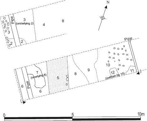
Figure 19.01: South and east defences at 1:200.
Grid squares: H16, G16, J16
The south gate (porta decumana), labelled Gate 3 in Daniels system of building codes, was initially investigated as part of Site 7 in the 1977 season when a trench was dug across the south defences to locate the curtain wall and defensive ditch with an offshoot to determine the position of the gate. More extensive exploration of the south gate’s remains was undertaken in 1978 when the structure was incorporated into Site 11. The north-west part of the gate, corresponding to most of the west tower, was never exposed, however, nor was the majority of the western passageway.
The remains of the gate had been extensively robbed and further damaged by modern intrusions. Much of the north side of the west tower had been obliterated by the course of an eighteenth/nineteenthcentury waggonway, but traces of the spina piers remained. Modern drains cut across the surviving remains which had largely been reduced to their primary foundation levels as a result of stone robbing.
The pre-fort ploughsoil was recognised at various points overlying the natural yellow-orange clay subsoil (H16:18), including south of the west guardtower (G16:30), on either side of the curtain wall around 3m further west (G16:34) and next to the south respond in the west passageway (H16:17). It took the form of a grey clay with slight yellow-orange streaking. Evidence for the ground being cleared by fire before construction was also found in a couple of places in the form of fairly extensive patches of orange and black, burnt clay on the surface of G16:34 on the north side of the curtain wall (G16:33) and over H16:17 at the edge of the western passageway (H16:16).
In plan the porta decumana followed the general pattern of the principal gates at Wallsend and the other Hadrian’s Wall forts, featuring twin arched passageways separated by two spina piers and flanked by a pair of rectangular guardtowers. Arches towards the front and rear of each passageway would have sprung from the spina piers and a pair of responds attached to the sides of the towers. Notionally it was the fort’s rear gateway, giving direct access to the via decumana and the area behind the central range buildings. However, as the only one of the fort’s major, double portal gates to lie south of Hadrian’s Wall, it may in consequence have played a more significant role in the history of the fort than some of the other gateways.
All four walls of the east guardtower were traced enabling the dimensions of the tower to be gauged, but the interior was not explored. With the exception a 0.85m length of masonry forming part of the north wall (J16:13) only the foundations remained (J16:21–24). These were composed of cobbles set in pink clay. Most of the north, east and west foundations were exposed, but the south-west corner had been completely removed by a later pit (J16:19) and the edge of north-west corner had also been destroyed, whilst only a narrow strip across the south wall foundations (J16:22) was revealed. The width of the foundation deposits varied from 1.30m in the case of the north and west walls (1.50m including responds), 1.35–1.40m for the east wall, right up to 1.55m for the south wall. The foundations for the north and south responds projected some 0.20m further and were respectively 1.35m and 1.45m wide (N–S). The southern (outer) respond was withdrawn some 1.50m from the outer face of the fort wall, whilst the shallow recess between the two was 1.35m in length. Based on the extent of the foundations the overall external dimensions of the tower were estimated at 5.70–5.90m (N–S) by 5.35m (E–W), excluding the responds, whilst the interior of the tower measured c. 2.70m (E–W) by 3.00m (N–S). The actual plan dimensions of the standing tower walls would have been somewhat less, however, judging from the surviving north wall masonry, which was set back c. 0.15–0.20m from outer edge of foundation deposits. There may have been a similar offset along the interior face, but this was less clear.
This surviving fragment of the north wall (J16:13) comprised three large, dressed blocks of coarsegrained sandstone, two belonging to the internal face and one to the external, north face. The blocks were 0.30–0.50m wide along the wall faces, c. 0.30m high and extended 0.45–0.55m into the thickness of the wall, generally tapering inwards slightly. The resultant overall width of the wall was 1m. The size of the blocks left little space for wall core but one large piece of sandstone rubble was noted set vertically between the tails of the facing stones. The rest of the wall masonry had been removed, its position being marked by robber trenches filled with brown, grey brown or black sandy soil and sandstone rubble (J16:07–09, 11). Nevertheless the 1.00–1.05m recorded width of the north (J16:07) and east (J16:08) robber trenches implied that all the walls were a similar width and significantly narrower than the foundation deposits (the west wall would presumably have been correspondingly wider where the responds were present). The impression of blocks of masonry was even preserved in the clay foundation (J16:23) at the base of the north wall robber trench.
Next to the east wall foundations a narrow strip of yellow clay (J16:12), some 30mm thick, belonging to the primary rampart base, was exposed.
Traces of the foundations for the two spina piers (H16:23–4) were identified, although in neither case was their full area exposed. They were composed of dark pink puddled clay and largish chippings. The east side of the inner (north) spina was revealed including both the north-east and south-east corners, plus a north-south strip roughly midway along (H16:23). In the case of the front spina (H16:24), only the north-east corner, another north-south strip and the south-west corner were traced. On this basis the dimensions of the two pier foundations were shown on the plan (P125) as 1.80m square (H16:23) and c.1.75m (E–W) by 1.70m (N–S) (H16:24), though the figures recorded on the context sheets were somewhat greater at respectively c. 2.00m (N–S) and c. 1.95m (N–S) × c. 1.80m (E–W). The two pier foundations were 0.90m apart and the estimated width of the east and west passageways between the foundations and those of the corresponding responds was respectively c. 2.40–2.50m and perhaps 2.50–2.60m.
A stone-lined drain was noted in the east passageway (H16:21) which might have been primary, or at any rate have belonged relatively early period in the gate’s structural history. This was perhaps a continuation of the drain channel (J13:09, J14:25) traced running alongside the west end of Building 12 further north on the via decumana. It was located in two places beneath a later, possibly post-Roman drain channel (H16:06). To the north it was neatly positioned on the west side of the passageway, next to the rear spina, and was traced over a distance of 1.5m, but further south it appeared to have shifted further to the east. Both side walls survived in the northern section, each composed of a single coarse of dressed rubble blocks lining a 0.22–0.28m wide channel. The latter still contained an original fill of gravelly, gritty wash including fragments of pottery and a few stones (H16:22) along its west side. Only the east wall of the drain was preserved further south, the other side having been removed by the later drain channel. The height of the stones in the side walls was variously recorded as 0.09–0.10m and 0.13m.
The primary road level through the gateway was not identified, even in places where excavation was taken down to the natural subsoil or the pre-fort ploughsoil and had evidently been removed by later truncation in many areas.
Only the east and south sides of the west gatetower were examined. The surviving remains there had been reduced to the level of the foundations with the exception of a short section of stonework possibly belonging to the southern end of the west wall (G16:27). The estimated overall dimensions of the tower were 5.80m (N–S) by 5.40m (E–W), including the responds. The primary foundations of the east wall (H16:10) and the south-east corner (H16:11), uncovered in 1978, consisted of dark pink puddled clay, large cobbles and some cut stone, becoming very stony whilst the clay changed to a much yellower colouration in the northern part of the gatetower. Some traces of flagging were noted over part of the clay in the foundations of the east wall (H16:10) plus a layer of chippings over the south respond in places (H16:09). The full width of the east wall foundations was not exposed so this can only be estimated by analogy with the equivalent part of the east gatetower. Their length from north to south is shown on the plan as c. 5.80m, although the context records and associated sketch plan suggest the northern edge was cut by the coarse of an eighteenth-century waggonway (H16:20). The foundations of the front and rear responds were traced, the former (H16:09) measuring 1.35m in length (N–S) and projecting up to 0.35m eastward into the passageway, whilst the latter (H16:19) were shown as c. 1.45m in length (N–S) and c. 0.20m wide (E–W). The recess between the two was c. 1.30m in length.
The foundations of the tower’s south wall were composed of the usual pink, puddled clay and cobbles (G16:32, H16:11). Their width was apparently somewhat irregular, increasing from 1.60m to 1.80m at the junction with the west wall, to judge from the site plan. A robber trench, filled with orange sandy clay and small stones (G16:31), had removed the actual masonry of the south wall. Further west, beyond the tower, the recorded width of the fort curtain wall foundations (G16:32) was 1.95m.
A course of well-laid and firmly set, large blocks (G16:27) was interpreted as forming the southern part of the tower’s primary west wall. The stonework was seen to extend 0.60m from the northern edge of the Site 7 offshoot trench to the point where it adjoined or was abutted by an east-west aligned, foundation of pitched stone (G16:04), which extended westward along the line of the primary curtain wall and clearly represented a secondary, if not post-Roman, feature. Stonework G16:27 was shown on site plan P88 in such a way as to suggest that the west face of the wall may have been preserved, but the manner of its depiction on the main site plan (P125) is less compelling in this regard and it may simply have comprised a section of wall core. Its positioning in relation to the secondary, pitched stone foundation suggest a possible association with that feature and it is therefore considered further below.
Several features which could relate to later modifications to the gate were identified by the excavators. For the most part these were eventually dismissed as being of post-Roman date. However the 1997–8 excavations revealed evidence for later Roman repairs and refurbishment of the defences and it is worth reexamining the 1977–8 features in this light.
A small area of rough but deliberately laid cobbling (J16:14) was exposed on the south side of the east gatetower. This was interpreted as the surface of a Roman road covering the area of the berm between the tower and defensive ditch outside the fort circuit. The cobbles were not removed to reveal the underlying levels so there is no clear indication as to where it fitted in the sequence of Roman structural periods. They were overlain by an obviously modern feature – a rather irregular line of mortared stones, of indeterminate function, sitting on a dirty grey soil flecked with mortar and terminating at its east end in a moulded plinth stone which may have been a reused Roman plinth (J16:06).
Along the east side of the eastern passageway a layer described as a densely packed, possibly laid surface of coarse-grained sandstone cobbles or ‘cobble rubble’ (J16:20) was the lowest level uncovered. The context sheet includes a comment that this may have been the illusion of a surface created by the densely packed nature of the layer. This was covered by a further layer composed of various sizes of cobble rubble in a matrix of grey-black soil (J16:15), 0.10–0.15m deep. It was noted that in its extant state this did not appear to be an actual surface but could perhaps represent a disturbed road surface. In the context database J16:15 was treated as a possible Roman level whereas the underlying layer, J16:20, was not included and was presumably assigned a post-Roman date. Both contexts were qualified as ‘modern’ on the actual context sheets, though it was also acknowledged that no modern material was actually found in J16:15.
A large, stone- and clay-filled, sub-rectangular pit (H16:08, J16:19) had cut away the south-west corner of the east gatetower foundations (J16:21–2), and additionally extended southwards, where it cut through cobbled surface J16:14, and westwards into the gate passageway, where it underlay cobbling J16:20. The latter was not removed to expose the full area of the pit, but the pit’s stone packing was seen to continue west of J16:20, in the bottom of the cut for a later drain channel (H16:04). The pit contained three large, flattish blocks (J16:17; J16:18), probably reused, the largest measuring 0.68m × 0.62m × 0.35m. These were packed around with and covered by yellow and pink clay, probably a mixture of redeposited natural and foundation clay. The three blocks and the stone and clay fills at the south-west angle of the tower were overlain by a layer consisting of large pieces of sandstone in grey-black clayey soil (J16:16), perhaps representing the fill of a later robbing intrusion or conceivably the 1929 sondage which located the south-west corner of the east tower (Spain and Simpson 1930, 489, cf. Plan facing p. 486).
The pit was generally interpreted as a modern feature by the excavators. Its relationship with cobbles J16:20 was described in greatest detail in the context entry for H16:08. The pit and its fill deposits could be seen to extend underneath the cobbles with a clay band between. Extending from the northern edge into the area below the cobbles there was a band of black, dirty modern fill. This black fill, which was explicitly said to lie below the cobbles, was not regarded as an integral or original part of the feature, but rather as material which had collected on top of the pit fills (and particularly around the edge of the cut for the pit) after they had subsided a little within the pit. The excavator argued this would tend to imply a modern date for the pit since the settlement probably occurred relatively soon after construction. However confirmation of this interpretation is lacking. The description of the dirty black fill as modern was presumably based on the reasonable assumption that it represented colliery debris, but it is not clear whether this was really the case or whether any modern finds were actually recovered from it. Hence the pit and the stone blocks set in it could, alternatively, be envisaged as forming part of a later Roman reinforcement or underpinning of the southeast corner of the gatetower, which would provide a coherent functional explanation for them.
Another feature of uncertain periodisation is the secondary phase of the drain through the east passageway (H16:06). This followed essentially the same course as the earlier Roman drain (H16:21), which it must have overlain or removed, and cut the the western edge of pit H16:08/J16:19. The side walls were constructed with roughly dressed, sandstone rubble facing stones and survived better on the east side than the west, The channel appeared to have also been relined with vertically set flags and was filled with a mottled grey sandy clay silt (H16:07). The pitched flags were reminiscent of the side walling used in the drain which ran around the south end of the granary and past the south-west corner of the principia, although in that case the slabs appeared to have featured from the outset. The coarse of the drain was overlain by a broad linear spread of dirty, dark grey to black sticky soil, containing coal, brick, mortar fragments and some redeposited clay (H16:04), which appeared to form the fill of a cut through the cobbled layers to the east (J16:15, J16:20).
The drain was initially thought to be Roman in date, its pitched slab lining being added to the inked phase plan of the gate, but was later interpreted as a probable modern feature. In the context database it was listed as an eighteenth-century trench. The stratigraphic reasoning is convincing. The composition of the uppermost fill material (H16:04) indicates it was colliery era debris which had presumably filled the cut for the drain channel after it had gone out of use later in the eighteenth or early-mid nineteenth century, although it is curious that a colliery drain should so closely follow an earlier, Roman one.
The south gate produced very little pottery; an intrusive (?) incomplete mortarium rim, possibly from a third- or fourth-century Mancetter-Hartshill vessel from the fill of the early drain (H16:22), and some third-century material from the disturbed cobbling (J15:15).
Despite extensive robbing and the presence of numerous modern intrusions the outline of the primary porta decumana was established with reasonable clarity. However the remains yielded disappointingly little evidence for later alterations such as the blocking of either of the portals or a succession of road levels which might be related to the structural sequence recorded outside the south gate in 1991. The stone foundation pit H16:08/J16:19 – if it is assumed to have been Roman – not only encompassed the south-east corner of the east tower but appears to have extended part way across the east passageway as well. It did not close off the passageway completely, however, and in any case appears more substantial than would be required for a simple blocking wall unless the arch of the portal also needed rebuilding. The two layers of cobbling identified in the east passageway (J16:15, 20), the uppermost (J16:15) evidently disturbed, overlay the pit and were clearly relatively late in the sequence if not post-Roman. Indeed, the most difficult issue with regard to the interpretation of this gate is the uncertainty as to whether secondary features should be assigned to the Roman period at all. Differing opinions were expressed in the context notes at various stages over the course of excavation and thereafter, with most of the features eventually being dismissed as belonging to the colliery period, although the reasoning behind this is not always clear. Much seems to have depended on the character of certain dark deposits, notably that extending over the northern lip of the foundation pit beneath cobbling J16:20.
The sequence of defensive ditches recorded outside the gate by TWM in 1991 provides more substantive clues regarding the gate’s likely structural history (Hodgson 2003, 19–21). The implications of this data are analysed in Chapter 20.
Grid squares: G16–17
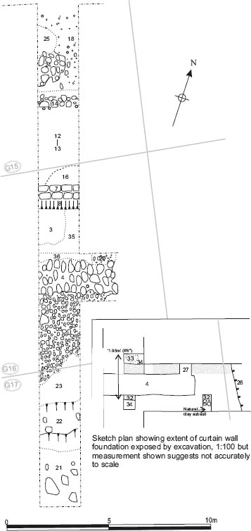
A trench was excavated across the southern defences a little to the west of the porta decumana in 1977. In the same season a branch trench, 6.40m long and 2.35m wide, was extended eastwards from the first trench, along the line of the curtain wall, to reach the nearest tower of the gate (Fig. 19.03). The main, north-south aligned trench was 24.50m in length and 2m wide, and extended southward from the intervallum road, traversing the rampart, curtain wall and berm to terminate part way across the innermost ditch. Once again the Roman levels had been been severely truncated by later activity and there was some difficulty in determining whether certain features should be interpreted as potential later Roman modifications to the defences or as colliery period structures.
The foundations of the fort curtain wall were traced as a 1.95m wide band of puddled pink clay and cobbles (G16:32) encountered at a point c. 12.15m from the northern end of the main trench and exposed at various places in the offshoot trench to the east. The foundations cut the pre-fort ploughsoil (G16:34) and underlying natural clay subsoil. The masonry of the curtain wall itself had been removed by a robber trench (G16:36) filled with small stones in a slightly sandy, clayey grey soil matrix, which was uncovered over the northern edge of the foundations in the main trench.
A strip of mixed grey and yellow clay (G16:35), which probably represented the primary rampart, was revealed, overlying the northern edge of the curtain wall foundations, as well as the pre-fort ploughsoil and the clearance deposits (G16:33). It extended c. 2.15m from the northern edge of robber trench G16:36 as far as the construction cut (G16:08) for a stone-founded, brick wall (G16:07) belonging to the colliery period. (To the north of that wall the only other features and levels exposed in the trench were probably modern.)
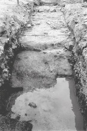
Beyond the curtain wall foundations, a pink-grey patchy clay incorporating a few stones (G16:23) was uncovered on the surface of the berm immediately to the north of the lip of the inner ditch (which actually lay in grid square G17, though its contexts were still numbered as G16). The distance between the lip of the ditch and the southern edge of the foundations was not specifically recorded, but can be estimated at around 5.20–5.50m. A homogenous pink clay (G16:22) was exposed by the sloping side of the ditch and presumably represented the natural subsoil in this area, although this was not defined as such and apparently differed somewhat from the yellow-orange clay subsoil (H16:18) revealed at various points in the south gateway. The ditch was filled with a very dirty, grey-black, coal-stained clay loam and worked sandstone blocks – both rubble core and facing stones – presumably tumbled from the curtain wall (G16:21). This was overlain further to the south by an orange clay fill (G16:28), up to 0.25m deep. Although the ditch took up the southernmost 5m of the trench, that did not represent its full width, which was not actually determined, but clearly extended beyond the end of the trench. Furthermore, the excavators were unable to fully empty that section of the ditch they did open, due to a powerful flow of groundwater which filled the bottom of the ditch at the south end of the trench, causing it to be abandoned.
It is uncertain whether this ditch formed part of the primary defences of the fort or was a later addition. The fill contained late third-century pottery, but the description of fill G16:21 suggests that the ditch may not have been completely backfilled until the colliery period. Following investigation of the ditches outside the south gate by Tyne and Wear Museums in 1991, it has been argued that this represents the course of the primary inner ditch as recut and enlarged later in the third century (Hodgson 2003, 19–21).
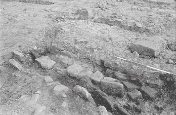
The most significant of the later features identified in the Site 7 trenches was a substantial, pitched stone foundation (G16:04; cf. H16:14), 1.20m in width, overlying the clay and cobble foundation of the primary curtain wall (Fig. 19.05). The sandstone blocks used were up to 0.50m in length but averaged 0.35m long by 0.20m wide and 0.30m high. They were traced over a total distance of 4.50m running from the western edge of the main trench eastwards towards the south gate as far as the surviving fragment of masonry interpreted as belonging to the west wall of the west guardchamber (G16:27) where they petered out. Masonry G16:27 appeared to adjoin the north side of the foundations, suggesting that they were associated, though they need not have been contemporary. On the south side of foundations G16:04 the berm was covered by a surface of worn cobble stones set in in grey clay (G16:05), up to 3.70m in width (N–S), with a further 1m of more scattered metalling to the south beyond that. This cobbling appeared contemporary with the pitched foundations. Abutting the foundations on the north side was a layer of orange gravel and clay (G16:03), with coarse sand and scraps of sandstone. This overlay the primary rampart deposit (G16:35) and, like the latter, extended as far as the cut for the colliery period brick wall (G16:07–08). The layer was interpreted as a possible construction level in the primary rampart, but, whereas level G16:35 was cut by the curtain wall robber trench (G16:36), G16:03 may be judged to have overlain the robber trench, on the basis of the successive sketch and site plans, although there is no explicit record of the relationship between the two contexts. It should therefore be interpreted as a later deposit, probably contemporary with the pitched stone foundations.
Figure 19.04: North lip of the south ditch looking north with pitched stone foundation G16:04 visible on the line of the curtain wall in the background.
The pitched stones were originally interpreted as foundations for the fort curtain wall (and are listed as such in the context database), but it was noted that they cut the robber trench for the primary curtain wall (G16:36) and were therefore quite reasonably reinterpreted as another post-Roman wall foundation in the context notebooks. Nonetheless, in view of the substantial nature of these foundations, their coincidence with the line of the primary curtain wall and the evidence revealed by the 1997–8 excavations for rebuilding work along the west curtain, the possibility that they represent a reconstruction of the south curtain at some stage later in the Roman period cannot be entirely ruled out. This would, however, imply that such a reconstruction involved reducing the primary curtain wall right down to its foundations, removing all the original masonry and even providing new narrower foundations (1.20m wide instead of 1.95m) composed of large blocks of pitched stone. This might have been associated with the reinstatement of the rampart bank (G16:03) and cobbled surface on the berm.
Two features to the north of the surviving rampart levels also merit a brief note (these lay partly or entirely within grid square G15 but were numbered as G16). Beyond the colliery era brick wall G16:07, a 3.5m broad layer of grey clay and stones (G16:12), badly contaminated by overlying deposits of coal slack, was exposed which was identified as the remnant of eighteenth century topsoil. This in turn covered a layer of stones (G16:13), which included some modern material perhaps intruded into it by plough disturbance. If the stone layer did indeed lie beneath the eighteenth-century soil layer – perhaps the remnant of the pre-colliery ploughsoil – it might represent the destruction of rampart back structures by post-Roman ploughing or other disturbance.
Immediately north of stone layer G16:13, and some 7.20m from the pitched stone foundation, a strip of large and medium-sized sandstone cobbles (G16:14), c. 0.45m in width, ran across the main trench on an east-west alignment, parallel with the line of the curtain wall. The cobbles were set on a 0.80m wide band of homogenous yellow clay (G16:15), similar to the natural subsoil, which extended a little further north. This feature was initially interpreted as the foundation for a rampart revetment but later dismissed as modern like all the other features in this part of the fort. This is quite likely but no material, either ancient or modern, was apparently recovered to assist the dating of the feature and its position would be consistent with that of a rampart revetment. The intervallum area immediately beyond, at the northern end of the trench, contained an extensive deposit of grey clay and cobbles (G16:18), and smaller spreads of large cobbles in orange and grey clay (G16:24) and very compact, dark pink-grey clay (G16:25), both located on the west side of the trench. However none of these layers, which all sat at the same level, exhibited any obvious indications of wear and consequently they were not interpreted as intervallum road levels and again were considered to be relatively modern in date.
The grey loam and tumbled sandstone blocks filling the south ditch included sherds of calcite-gritted ware and Crambeck reduced ware, dating to the late third century or later (G16:21).
Grid squares: L16–17, M 16–17
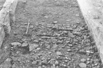
Most of the excavation of the interval tower to the east of the south gate took place during 1978 as part of the overall work in the retentura. The outer face of the tower’s east wall was examined in 1979, being designated Site 14. For the most part the investigation involved the excavation of a series of very small ‘keyhole’ sondages designed to determine the position of the tower by tracing the edges of the wall foundations or faces (Fig. 19.01). The Roman remains had largely been reduced down to foundation level by post-Roman robbing and modern disturbance, which was especially severe in this part of the fort. In view of the straightforward nature of the remains exposed and the simplicity of the stratigraphic sequence, recording of the tower was principally by means of a single site plan (P133) drawn in 1978 and adapted in 1979. As a result not all the excavated deposits or features were given context numbers.
The site plan shows that the clay and cobble foundations of the curtain wall and tower walls were traced most extensively along the south side of the tower, with both the external and internal faces being uncovered along with parts of the wall core. The internal north-east and north-west angles of the tower were also revealed along with short stretches of the external faces where the tower’s side walls joined the fort curtain wall. However only one 0.25m square slot was dug to locate the external face of the tower’s north wall. This picked up a clear colour change in the clay, from pink to brown, but it was not absolutely certain that this did represent the edge of the tower. Virtually all of the coursed masonry of the tower and curtain walls had been removed by robber trenches (L17:02–03; M17:03) filled with dark brown sandy and gritty soil, which contained a lot of small sandstone rubble, plus much larger rubble blocks, up to 0.50m in length, in the case of the curtain wall robber trench (L17:03). However neat facing stones were evident on the site plan along the inner face of the west and north walls of the tower. These stones probably formed a kerb defining the edge of the clay and cobble foundation. At the junction of the tower’s east side wall and the fort curtain the foundation clay (M17:05) of the two walls was a different colour changing from pink to blue-grey respectively. Impressions of two of the stones forming the north face of the curtain wall were evident in the clay at this point.
The tower was virtually square, measuring c. 5.80m (N–S) by 5.70m (E–W). The side and rear walls were around 1.25–1.30m wide, although the east wall foundations (M17:05) appeared to taper inward towards the north, narrowing from 1.30m to c. 1.15m in the 0.80m excavated length. The curtain wall foundations appeared broader (1.95m) to the east of the tower than to the west (1.75m) and varied between c. 1.45m and 1.70m in front of the tower itself. Internally, the tower measured 3.15m (E–W) by 3m (N–S) and was recessed c. 0.25–0.45m into the curtain wall. Only the natural yellow clay subsoil remained along the south side of the interior, but undescribed darker material is shown at the north-east and northwest angles suggesting a different level survived there, probably representing an overlying floor or makeup layer.
In the external angle between the curtain wall and the tower’s east wall an area of light grey silty clay loam (M17:07) representing the pre-fort ploughsoil was uncovered and recorded in section. This was overlain by orange and purple-black staining (L17:06) perhaps as a result of burning to clear the site prior to construction. Covering the burnt level was a layer of was grey silty clay loam with some orange and black flecking (M17:04) which formed the solitary surviving rampart deposit. Patches of soot and charcoal and burnt orange clay were recorded in plan amongst this rampart base deposit and may have formed part of the underlying burnt level protruding through. On the opposite side of the curtain wall a grey silty clay loam indistinguishable from the rampart deposit was uncovered forming the surface of the berm overlying the natural yellow clay subsoil. This was treated as the same context number as the rampart layer (M17:04). Both the M17:04 deposits may have originated as upcast deriving from the digging of the foundation trench for the curtain wall and tower through the pre-fort ploughsoil.
The remains of the interval tower and adjoining features can all be attributed to the primary defences of the fort, with no evidence for any later modifications surviving. There were no significant finds from the tower.
Grid squares: N16–17, P16–17
The south east angle tower was included within the limits of the 1978 excavation as Site 13, when most of the surviving remains of the tower were planned (P129) though few context numbers were assigned. Further detailed excavation occurred in August-September 1979 when the north end of the spur of Hadrian’s Wall, known as the Branch Wall, which led down from the fort to the river, was examined. Narrow trenches and small slots were also dug to trace the course of the adjoining sections of the fort wall north and west of the angle tower. The position of the Branch Wall and the curtain north of the tower had already been traced by trenching in 1929.
As elsewhere along the south-east defences numerous modern intrusions and extensive robbing which had removed all the upstanding masonry and even some of the foundations. Investigation was therefore limited to recording the surviving foundations and differentiating the associated clay core from natural and re-deposited clays. The 1929 excavation trenches (P17:03, 05, 07) were located and emptied.
The south east angle tower could only be partially exposed and traced due to the number of modern intrusions (Fig. 19.01). It survived best along its southwest side and particularly at the west corner where the pink clay and river-washed cobble foundations remained in situ and were planned in 1978 (P129). The outer edges of the north-west and south-west wall foundations were both still traceable at these points, round the corner and as far as the junction with the south curtain wall. Some pink clay and cobble deposits were also recorded in the area of the north corner and extending a little way down the northern east side of the tower, where a couple of sizeable stones and the imprints of others may have belonged to the external kerb. In the interior the west corner was correspondingly well-defined, plus to a much lesser extent the north and, even less certainly, south corners. The north-west wall foundations – which alone could be measured accurately – were 1.40–1.55m wide. No internal floor levels survived, however, with the natural yellow clay subsoil being exposed on all sides. On the basis of this data the external dimensions of the tower were estimated at 6.40m from the outer face of the south-east angle curtain to the rear of the tower and 6.00m from east to west. The tower appear to project inwards 4m from the inner face of the curtain. Internally it probably measured 3.50m (E–W) by 3.35m (N–S), though there was a degree of uncertainty with this estimate, and like the other towers was probably recessed c. 0.30–0.40m into the curtain wall.
With the exception of a spread of pink clay, up to 2.50m wide, all trace of the Branch Wall foundations had been removed at the point where it joined the south-east angle of the fort (P177). However, 2m south of the curtain wall, the remains of the foundations survived in better condition (P17:06). These were constructed of river-washed cobbles set in pink clay, in the usual fashion, and continued right to the south end of the trench, marked by a modern stone founded garden wall (P17:08) lining the pavement of Camp Road, some 4m from the fort wall. At 2m (6ft 8in) in width, the Branch Wall foundations were relatively narrow, whilst the edges were defined by the use of larger boulders which were c. 0.25–0.30m broad across the face and tapered inward 0.25m-0.35m (Fig. 19.06).
Several small trenches were excavated to determine the precise course of the fort wall to the west and north of the angle tower. The edges of the curtain wall’s cobble and pink clay foundations (N17:02) were traced up to 6.25m west of the junction with the angle tower, beneath the stoney fill of a robber trench (N17:05). This showed the stone foundations were 1.85m broad next to the tower, but the pink clay could be seen to extend some 0.25–0.30m further south, beyond the line of the depression left by the outer kerb stones of the foundations. Along this outer edge the foundations could be seen to cut the 0.05–0.15m deep layer of grey silty clay loam (N17:03) which formed the pre-fort ploughsoil, overlying the mottled yellow-orange silty clay natural (N17:04). The site plan (P168a) shows ‘“rusty” charcoaly patches’ on the surface of the grey silty clay at one spot, perhaps the residue of site clearance burning.
The curving coarse of the clay and cobble curtain wall foundations was traced for 6m north of the tower, the stone foundations being generally wider, at 2m, than those to the west. The use of slightly larger boulders or cobbles to form the edges was evident, but again the pink clay extended well beyond these kerbs (perhaps c.0.50m on average), particularly along the outer edge, where it continued beyond the limits of the trench in places, but also along the inner edge, notably near the junction with the tower.
Grid square: P14
The interval tower (Tower 5) positioned midway between the east gate and the south-east angle, immediately north-east of Building 12, was excavated in July-September 1978. The 9m × 9m excavation trench designated Site 12, formed an adjunct to that season’s main area excavation of the retentura and encompassed the whole area of the tower, along with short stretches of the adjoining east curtain and rampart (Figs 19.01, 19.07).
Figure 19.06: The foundation of Branch Wall next to the south east angle of the fort, looking south west.
Nineteenth-century development had taken a particularly severe toll in this part of the fort, reducing the tower and the curtain wall down to the level of their foundations and stripping away virtually all the stratigraphy, both internal and external, above the pre-fort ploughsoil. Only on the north side of the tower did a small pocket of rampart deposits survive. The ploughsoil took the form of a fairly sticky, mid-grey clay, which was 0.10m thick inside the tower (P14:05) and 0.05–0.10m deep to its south and west (P14:03). No trace of turf was preserved, but an irregular, patchy skim of burnt clay was exposed overlying the ploughsoil to the west of the tower, covering an area around 1.50m square. This was orange and black in colour and only 10–20mm deep, and probably reflected the use of burning to clear the site prior to construction. The underlying natural yellow clay subsoil (P14:04) was also revealed where modern intrusions had cut through the ploughsoil. Some 2m to the west of the tower the deep cut of a modern road divorced the tower from the Roman levels of the via quintana beyond.
Although the tower’s masonry superstructure had been entirely removed, the wall foundations survived surprisingly well. Apart from a number of modern intrusions, notably at the south-west corner, only the north wall foundations (P14:09) had been substantially robbed out, a 1.05–1.25m wide trench (P14:23) having removed the cobbles down to the pink clay base over a distance of more than 3m, leaving only a short stub at the junction with the curtain wall. The robber trench was filled with a mixture of orange-grey clay, stone, brick and coal lenses. The rest of the wall foundations were largely intact and were generally c. 1.25–1.35m wide, although the south foundations appeared a little narrower at 1.15–1.25m to jude from the site plan (P117). Externally the tower measured 5.5m, from north to south, and protruded 3.70–4.00m from the inner face of the curtain wall (the length of the tower’s south wall foundations apparently being slightly greater than that of the north wall). Internally, the tower measured 3.00m × 3.00m and was recessed 0.30m into the east curtain wall.
The interval tower’s foundations comprised two layers of cobbles packed and sealed into pink clay (P14:06–09), 0.30–0.50m deep overall. The cobbles were mostly water worn boulders but included a few pieces of sandstone rubble. Larger and sometimes squarer stones appear to have been deliberately selected to form the edges of the foundations. In the west wall foundation (P14:06) a difference was noted in size of these edge stones in the two layers: those in the upper layer being up to 0.30m in length, while those edging the lower layer were larger at up to 0.40m in length. However, no difference was noted in the size of the stones marking the edges of the two layers of the south wall foundation (P14:07), these being up to 0.40–0.50m long.
The excavation revealed a 9.10m length of the curtain wall foundations (P14:08) on the east side of the interval tower. These were constructed in the same manner as the tower foundations. The entire east face of wall was cut away by a modern concrete foundation slab for a brick wall (P14:22) which formed the eastern limit of the excavation area, meaning that the width of the curtain wall could not be precisely gauged. However a change in the colour of clay from pink to yellow glimpsed in the bottom of an intrusion to the east of the concrete slab suggests the breadth of the curtain wall foundations was c. 1.80m where they fronted the tower, c. 2.20–2.30m to the south and perhaps 2m to the north.
A small sondage, c. 0.50m square, dug to investigate the strip of rampart on the north side of the tower, showed that a 20–30mm deep layer of grey clay upcast (P14:26), presumably deriving from the foundation trenches, overlay the grey clay silt ploughsoil (P14:28) and the burnt orange clay spread (P14:27) resulting from site clearance. The upcast was covered by a 10mm thick layer of small stones (P14:25). This also extended over the northern edge of the tower wall foundations (P14:09) and might represent a construction level associated with the building of the tower and curtain. This was overlain in turn by the grey clay of the rampart bank (P14:24) which included pieces of coal.
Although no finds were recovered from the tower there is no reason to doubt that all the Roman features and deposits identified in Site 12 were associated with the initial construction of the fort’s defences, presumably during the Hadrianic period, based on the clear evidence for site preparation and the cutting of the various wall foundations directly into the original ploughsoil.
Grid squares: P11, Q7, Q8, Q11, R5, S5, T5
In 1979, a 2.10m wide trench was extended some 13m eastward from the north-east corner of the main Site 15 excavation area, providing a transect from the east wall of the praetorium across the full width of the intervallum street, rampart and curtain some 11m south of the east gate. This revealed the width of the intervallum road cobbling (P11:11) to have been c. 3.60m and uncovered the clay base of the rampart (P11:12, Q11:03) and the robbed out remains of the curtain wall. The rampart deposit was 4.40m wide and consisted of plastic clay, streaked orange, buff and pink in colour, with pockets of orange ironstone material and charcoal flecks. A small slot, 0.30m × 0.30m, was cut through the eastern edge of this deposit to reveal that it overlay a thin layer of sandstone dust and gravel chippings (Q11:06), perhaps associated with the construction of the curtain wall, which in turn covered a layer of grey clay loam (Q11:07), tentatively interpreted as upcast from the ditch or the wall foundation trench. The clay loam lay directly on top of the pre-fort ground surface and tapered down towards the curtain wall, being thicker at the west end of the slot. A rubble-filled robber trench (Q11:04), 2.15m wide and 0.35–0.40m deep had completely removed the masonry of the curtain, exposing the wall’s underlying pink clay foundations (Q11:05). The foundation clay was 2.10m wide and, along the western edge of the robber trench, it preserved impressions left by the wall’s inner facing stones. The clay foundation extended 0.20m beyond the line of the wall’s inner face and here was overlain by the rampart deposits (Q11:03, 06–07). The overall width of the curtain wall was difficult to estimate but was perhaps c. 1.7m.
No dateable material was found in any of these deposits, but they may all be assumed to relate to the primary defences of the fort.
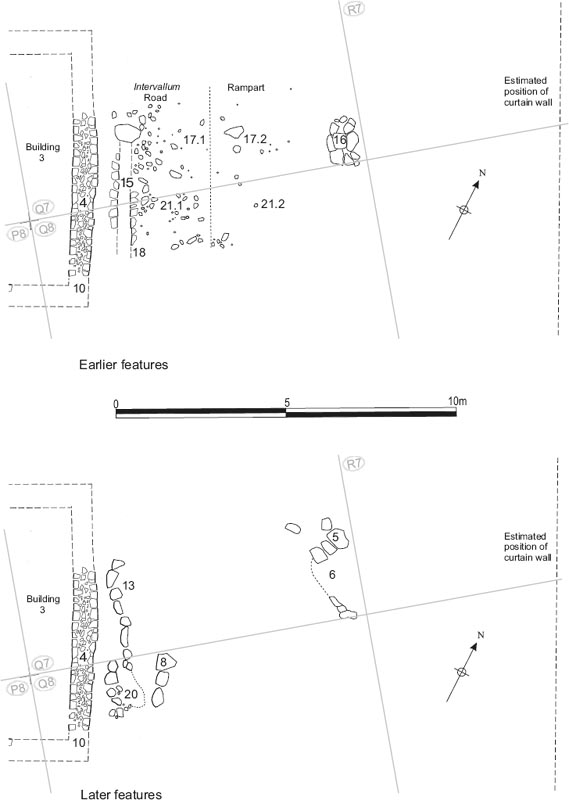
Further north, the area of the rampart immediately to the east of Building 3 in grid squares, Q07 and Q08, was investigated in 1983–4, whilst a narrow trench was previously excavated across the east intervallum road (Road 7) and eastern defences next to Building 1 in 1976 (Site 5).
The location of the rampart bank to the east of Building 3 was marked by a spread of clay (Q07:17.2, Q08:21.2), up to 4.6m wide. Its western edge lay no more than 3.30–3.50m from the end wall of the building (Fig. 19.07). Cutting into the eastern edge of the rampart level was a roughly oval flagged surface (Q07:16), which covered an area 1.75m (N–S) by 0.90m (E–W) and was composed of seven large and medium-sized flags and few smaller ones. This was interpreted as the floor of a possible bread oven. It was overlain by a deposit of yellow clay (Q07:06) which was bounded and reportedly cut to the north by a line of three large stones (Q07:05), 1.15m in length, with two more large blocks of rubble further north perhaps also being associated (Fig. 19.08). These stones may have formed part of the original oven or perhaps the fragmentary remains of a replacement.
Extending over the rampart area and intervallum street to the west of Q07:05 and Q07:06 was a rubble spread in a dark soil matrix (Q07:07, Q08:11) probably reflecting the impact of plough disturbance on the Roman levels. No trace of the curtain wall was uncovered. It probably lay just beyond the eastern edge of the site at this point and may well have been destroyed by the east wall of Simpson’s Hotel (Q07:03, Q08:19) with its associated construction trenches (Q07:09, Q08:07).
In the 35m long and 2.40m wide trench (Site 5), excavated across the eastern defences next to Building 1 in 1976, the remains of the rampart bank were revealed as a 2.40m wide layer of sandy grey clay (R05:06), flecked with charcoal and incorporating several lenses of gravel. This clay extended beyond the western end of the trench so its full width was not exposed. It was partially overlain by a further thin spread of heavy yellow clay, sand and gravel (R05:07). The sandy grey clay was cut to the east by the rubble and soil-filled robber trench (R05:04) which had entirely removed the stonework of the curtain wall. Only the heavy orange-brown foundation clay (R05:05) for the wall remained at the bottom of the robber trench. This foundation clay was 1.90m wide and included a few stones.
The eastern edge of the curtain wall foundations and robber trench cut through a deposit of light brown sandy clay (R05:08), containing relatively few stones, which was interpreted as the original Roman ground surface. This extended for 0.40–1.50m further east at which point it was cut away by a modern, north-south aligned, linear intrusion (R05:09), perhaps a former drain trench, with vertical sides and a flat bottom, and substantially wider to the north (1.90m) than the south (0.70m/0.85m). Beyond, a thick deposit of clay (R05:12) extended eastwards and was perhaps equivalent to R05:08, though not identified as such by the excavators. In section, its surface was seen to dip down from the level of R08:08, before levelling out, and the deposit appeared to fill a 0.50–0.60m deep depression extending 0.70m from the south side of the trench, perhaps a gully, whilst reportedly overlying a greyish sand/clay. The latter may be essentially the same as the yellow sand seen at the bottom of modern drain trench R05:09, perhaps bands of natural which presumably also extended beneath R05:08.
Figure 19.07: The interval tower between the south-east angle and east gate (Tower 5), looking south
Figure 19.08: Eastern intervallum road and defences in Q07 and Q08, showing earlier and later features. Scale 1:100.
A layer of black, burnt material (R05:03), 0.12m deep and containing much charcoal and coal, covered the full expanse of rampart clay except in the southwest corner of the trench. This was in turn overlain by a deposit of disturbed yellow clay (R05:02), up to 0.30m thick, containing brick, stone and burnt material. Both layers were cut by robber trench R05:04 and lay beneath the modern overburden (R05:01). Although neither was treated as a stratified Roman level in the Daniels post-excavation record, it is conceivable that R05:03 could represent the debris from industrial activity or perhaps bread ovens and imply that the rampart bank was removed at some stage in this area to make way for such processes, before subsequently being reinstated in the form of R05:02. The remains of the reinstated bank would in turn have been subject to later, post-Roman disturbance with material perhaps being intruded.
Figure 19.09: Building 3 east wall Q07:04/Q08:10 with the side wall stones of street drain Q07:15 in the foreground, looking west.
Overlying the entire eastern end of the trench were thick deposits of disturbed dirty greyish yellow and dark grey black clay and rubble (R05:10–11, S05:05, T05:02) and relatively recent coal slack (R05:13, S05:03, T05:03). Although the trench extended into grid squares S05 and T05 no stratified Roman levels were revealed there.
FINDS
Amphora stamp: 120–160 (no. 3, Q07:07)
Coin: illegible (no. 247, Q07:07)
Copper alloy: rod (no. 329, Q07:07)
Pottery: spindlewhorl (no. 15, Q07:07)
Decorated samian: 130–60 (no. D143, Q08:11)
Samian stamps: 160–200 (no. S47, Q08:11), 100–20 (no. S62, Q08:11)
The second-century grey ware from the lowest intervallum street level and/or the rampart deposit (Q07:17) is consistent with these forming part of the primary layout of the fort.
Figure 19.10: The 1976 trench across the east defences in grid square R5, at 1:100, showing upper (top) and lower (bottom) levels of excavation at the east end of the trench.
The rubble overlying the east intervallum road and rampart to the east of Building 3 included Crambeck reduced ware and a fourth-century proto-Huntclifftype rim in calcite-gritted ware (Q08:11).