In northeast Africa along the coast of Eritrea facing the Red Sea not far from the modern city of Asmara, a deep gulf cuts into the land towards the interior. It provides shelter from the winds in the Red Sea and a measure of security from the islands that lie near its entrance. This gulf, into which run several river valleys from the Ethiopian highlands, was called Annesley Bay in the colonial period as a commemoration of the British traveler George Annesley, who explored the region in the first decade of the nineteenth century. Today it is known as the Gulf of Zula, proudly displaying the name that it had borne, in a slightly different form, two thousand years earlier. In Graeco-Roman antiquity the gulf provided the principal point of access by sea to the southern interior comprising the Ethiopian highlands, and, in late antiquity, the Christian kingdom that had its capital at Axum.
From the sea any journey into the interior and to Axum itself had to begin from the port city of Adulis, which lay just a few kilometers inland from the western shore of the Gulf of Zula. It is the very name of Adulis that passed into that of Zula by way of a deformation as Azulis, which generated its present local toponym Azouli. The etymology of the word Adulis remains a mystery to this day, because it could be either Greek or Semitic, and there is no way of telling which it is. If Greek, the word would imply, from the privative prefix a-, an absence of slaves (douloi), but such an explanation seems highly implausible. Scholarly efforts to turn the name into a reference to a settlement of former slaves, who, being no longer enslaved, might be said to live in a “slave-less” place, are desperate measures that few have been willing to accept. But if the word is not Greek but Ethiopic, which is a Semitic language, the *ad* element would mean “place,” and that seems much more promising. A tribal designation of some kind might follow, and so “place of the Uli or Ule” may be the answer to this puzzle, exactly as Enno Littmann once suggested.1
Whatever the etymology, travelers both ancient and modern have noticed the scattered ancient remains a little to the east of Azouli, where Henry Salt identified the site in 1810 and the British first excavated in 1868. The foundations of several buildings, including a church, were discovered there, and subsequent excavations at the site by the Italians and French have turned up structures, coins, and artifacts that point to a relatively late period (2nd to 7th centuries AD) for the extant traces. Some of these pieces have been transferred to the Asmara museum. The church, of which remains are held in the British Museum, appears to be Byzantine, and another church of comparable date appeared in the Italian work under the Fascists. More recent French excavation at Adulis as well as a British survey reinforces the late date for the surviving remains. The ruins and objects, together with the name of Azouli itself, serve to establish decisively the location of the site.2 It lay near the confluence of three rivers and stood on the northern bank of one of them, the Haddas river. From antiquity to the present the Haddas served as a major route southwestward into the interior highlands and the territory of Axum.
In ancient literature Adulis appears as early as a famous merchant’s manual known as the Periplus of the Red Sea. This is a guide to ports for trading vessels operating across the Indian Ocean between the coasts of India and East Africa, and through the notoriously treacherous Bab al Mandab (“Gate of Lamentation”) up the Egyptian coast along the Red Sea. The Periplus includes detailed information about routes and commercial products in these regions during the middle of the first century ad. This date is now secure thanks to our knowledge of the reign of Malichus II, who is named in the text as king of the Nabataean Arabs in Transjordan. Coins and inscriptions guarantee that his rule encompassed the years 40–70 AD.3 In describing the East African side of the Red Sea the manual states:
About 3000 stades beyond Ptolemaïs of the Hunts [a city farther north along the coast] is the legal emporium Adulis. It is on a deep bay extending due south, in front of which lies an island called Oreinê that is situated about 200 stades into the farthest part of the bay towards the open sea and on both sides lies parallel to the coast; here at the present time arriving vessels moor because of raids from the mainland. Formerly they used to moor in the deepest part of the bay at the island called Didôros Island, right by this part of the coast; here is a ford crossing to it by which the Barbaroi dwelling roundabout used to overrun the island.4
The merchant’s description fits reasonably well the topography of Azouli on the Gulf of Zula, and the distance of approximately 3000 stades (300 miles) from Ptolemaïs of the Hunts, which, in all probability, is modern Aqiq, is reasonable. Unfortunately, the account of the offshore islands immediately alongside the gulf is couched in language that is far from perspicuous. Oreinê would appear to correspond with the island Dese at the head of the Gulf, whereas the account of Didôros Island as lying just outside the bay can only be explained if the island, to which the barbarians had access by a ford, has now become absorbed into the mainland through silting. One can only surmount the difficulty of correlating the description with today’s geography by postulating such a change in the coastline, and this is what the latest British team has reasonably proposed to solve the problem. One result of failing to recognize this change has been that the merchant’s description has impelled some commentators to propose that Adulis actually lay at Massawa in modern Eritrea, with its fine port, some forty miles to the north on the coast—an identification that appeared to be strengthened by the merchant’s reference to “numerous small, sandy islands” as one sailed out of the port into the open sea. Certainly the more than two hundred islands of the Dahlak archipelago between Massawa and the entrance into the Gulf of Zula correspond perfectly well with this description.5 But the ancient remains and the toponymy of the site that Salt identified long ago leave no doubt that his identification was correct.
By contrast, Adulis, though clearly identified as a port city, must have stood, like the present site, a few miles back from the coastal shoreline. Although it lacked any harbor of its own, this fact in no way invalidates its powerful claim to be a port city. It lies today some 7 kilometers from the water rather than the 20 stades (3.3 kilometers) indicated by the merchant manual, but silting can easily account for the difference, and a port town set back from the actual harbor would hardly surprise anyone who knows the relation of Piraeus to Athens or Ostia to Rome. It would be impossible to separate Adulis from the ruins near Azouli. The anonymous author of the Periplus was quite correct, however, when he said that it was an eight-day overland journey to the metropolis he called Axômitês, by which he obviously meant Axum. He clearly understood that Adulis was the place from which Axum had access to the sea and, equally, foreigners had access to Axum.
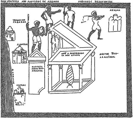
If the town of Adulis was situated, as it evidently was, some distance inland from the gulf coast, it necessarily cannot be imagined as the actual harbor at which maritime traffic with Axum would have anchored. But fortunately we know where that harbor was. It lay where there was a customs station by the name of Gabaza, directly on the coast farther into the southern end of the gulf. This place is mentioned in an account of the martyrdom of the Christian Arab Arethas in the sixth century, where it is explicitly described as an anchorage that was dependent upon Adulis.6 Hence Gabaza was the actual harbor for Adulis as the port city. Confirmation of this can be found in an extraordinary map of the region (Fig. 1) that occurs in the three manuscripts of a work by a sixth-century Christian traveler, Cosmas Indicopleustes, of whom we shall have much to say in the pages that follow. In this map Gabaza shows up, exactly as the Arethas text suggests, near Adulis but deeper into the gulf. The recent British survey team has persuasively identified Gabaza with the Galala Hills south of Adulis and Didôros Island as a hill that coastal change has now permanently attached to the mainland.7 The name itself, Gabaza, may possibly allude to a minor kingdom that could be inferred from a numismatic reference to a sixth-century king Ella Gabaz. 8 In any case, the form of the name appears to be derived from the verbal root for “protect” or “guard” in Ge‘ez (the classical language of ancient Ethiopia). The word Gabaza appears once again, without any allusion to the port, in a late antique Ethiopic inscription that apparently attaches this name to the cathedral at Axum.9 This would appear to reflect the dependence of the Christian kingdom of Ethiopia on the region that controlled both its trade and its naval activity in the Red Sea. To this the Gulf of Zula provided sole access. It was Axum’s window on the Arabian peninsula that lay across the water.
Figure 1. Drawing of the Adulis Throne in its geographical setting, as preserved in three manuscripts of Cosmas Indicopleustes. This drawing is oriented with North at the bottom and South at the top. Hence the northermost part of the Gulf of Zula is located at the bottom, with, going upward to the South, Samidi, Adulis, and the customs station at Gabaza above it. Axum, in the South, appears in the upper right corner with the name given in Greek as Axômê. The artist has reproduced the opening words of the two epigraphical texts that Cosmas cites, and he has erroneously followed Cosmas in thinking all the remains a single Ptolemaic throne. In the top left a Greek label reads, “Road leading from Adulis to Axum,” and in the top right the label identifies “Ethiopians on foot.” Reproduced from W. Wolska-Conus, Cosmas Indicopleustes, Topographie Chrétienne, vol. 1, Sources chrétiennes no. 141 (Paris, 1968), p. 367.
The history of ancient Ethiopia was inextricably bound up with that of South Arabia, including both the land of modern Yemen and the Tihāma coast on the western side of the present Saudi kingdom. The script of classical Ethiopic (Ge‘ez), was constructed from the letters that were used for the ancient South Arabian language known as Sabaic, and indeed the very word Ge‘ez derives from the Ethiopic verb “to move” or “to migrate.” There was a long history of Ethiopian intervention in the Arabian peninsula from the end of the second century ad onwards. Although the Ethiopians were expelled definitively from Arabia in the later third century, their rulers in subsequent epochs, both before and after their conversion to Christianity in the mid-fourth century, did not hesitate to lay claim to the Arabian territories they had formerly held. These lay in southwestern Arabia in a territory that became known as Ḥimyar. Since the Gulf of Zula was indispensable for the launching of expeditions across the Red Sea, the city of Adulis was therefore fundamental in facilitating the ambitions of the Ethiopians to re-establish their control in the Ḥimyarite area of the Arabian peninsula.
Accordingly, it is hardly surprising that Adulis served as a site for the public commemoration of Ethiopia’s foreign enterprises. Apart from the ancient remains that have survived for nearly two millennia until modern travelers discovered them, we know, through a literary text that has fortunately been preserved from the sixth century, about one significant monument at Adulis that is not there now. Yet it was clearly emblematic of the achievements and claims of ancient Ethiopia. It symbolized the campaigns against Arabia that Axum launched across the Red Sea in its struggle with a succession of Arab rulers. We know about it from Cosmas Indicopleustes, for whose work the manuscript illustrations of the Gulf of Zula, as mentioned earlier, were created.
Cosmas was a Christian from the so-called Nestorian branch of Christianity that had grown up in the Persian Empire. This is what is sometimes known as the Church of the East. Following Nestorius, the fifth-century patriarch of Constantinople, these Christians differed from Monophysites in emphasizing the human nature of Christ as well as the divine, though accepting the unity of the two (albeit in ways that distinguished them from the Chalcedonian orthodoxy). We do not know Cosmas’ real name, although the manuscript tradition has equipped him with a common Christian name derived from the Greek kosmos (for world or world order). He undertook to provide for the various Christian nations an annotated geography through a full account of his own international travels across the known Christian world. He did this in a book that bears the title Christian Topography. Cosmas had been active in Red Sea trade during the third decade of the sixth century, and it was at this time he went to Adulis.
There he came upon a marble throne that was clearly some kind of commemorative or votive monument—probably both at the same time—and big enough to accommodate a long inscription in Greek. 10 The throne, smaller than a real one that could accommodate a seated human frame but larger than an ornamental collectible, was an object that the Ethiopian king, or negus as he was called, had caused to be made and dedicated as a reminder of his victories and conquests. Both before and after the Christianization of the kingdom in the fourth century, dedications of thrones of this kind are mentioned in inscriptions. They were normally offered to the pagan god Maḥrem or his Greek equivalent Ares, just as much later, in the same spirit, they were dedicated to the Christian God, even when the language echoed the traditional forms of pagan dedication. Bases and loose blocks for twenty-six thrones have been found in the old city of Axum, as well as several more thrones in outlying sites. 11
For the most part, what survives are the stepped blocks of the throne’s base, but there are also indications that each throne had side panels and a high back. The German excavators considered that many of the inscribed stone panels found at Axum may once have actually been the sides of thrones. This is far from certain since some of the inscribed stones are simply too big, but others may well have belonged to thrones. The seat itself was called a manbar in Ge‘ez, from the verb “to sit.” By calling it a diphros, not a thronos, in his Greek narrative, Cosmas appears to have distinguished this somewhat smaller votive throne from a larger one that was big enough to accommodate a king. The word diphros is found elsewhere in the Near East as a designation for a small throne,12 and Cosmas clearly avails himself of this term to designate an Ethiopian votive one.
The drawing (Fig. 1 above) in the three manuscripts of Cosmas’ book, with its depiction of the Gulf of Zula near which Adulis was located, includes a sketch of both the throne and the stele at the site. The drawing of these objects more or less matches Cosmas’ description and locates the throne itself in a geographical setting that approximates the topography of the gulf, but, as it is most important to stress, with an orientation in which South is at the top rather than North. The drawing also shows, precisely as Cosmas describes it, an inscription written on the throne as well as, on the back panel, two male figures that presumably represented divinities. On Cosmas’ map Adulis is placed close to the coast of the gulf while Gabaza stands, as it should, on the coast itself and is called a customs station (telônion). Because of the orientation of the image, with South at the top, Axum appears disconcertingly above Adulis, rather than, as on all modern maps, below it.
The illustration with the Adulis throne in its geographical setting is but one of numerous illustrations in the manuscripts of Cosmas, and it is unclear whether he had any hand in drafting them or whether they were created later by copyists of his text. The oldest of the three manuscripts that contain the drawing of the throne is an uncial Vatican manuscript of the ninth century. The other two, one in the monastery of St. Catherine in Sinai and the other in the Laurentian library in Florence, can be dated to the eleventh century. Whether or not they go back to Cosmas himself, they undoubtedly represent exactly what he describes. 13
The throne was made of white marble, but not, as Cosmas observes rather pedantically, of marble from the Greek island of Proconnesus. If Cosmas were sufficiently knowledgeable, he may perhaps have been aware that Proconnesian marble had, in fact, been extensively used at Adulis, as modern excavations and surveys have revealed. He tells us that the throne was located at the entrance to the city, on the west side and oriented toward the road to Axum. It had a square base and was supported by four small columns at each of the four corners, as well as by a fifth and thicker column in the middle of the base with a serpentine design. The seat itself was placed on the five columns, with a back standing behind armrests on the right and left sides. The whole was cut out of a single block, measuring a little over three feet in height (2½ cubits). The surface, according to Cosmas, was covered with the Greek inscription.
The Adulis throne, as Cosmas describes it, bears a close resemblance to the thirty odd examples that have been discovered in Ethiopia, but the placement of the seat of the throne on top of pillars at the four corners of the base and one in the middle is altogether unexampled. The sides and back, however, appear consistent with examples that do survive, and the German excavators at Axum have proposed a drawing of the throne in a form comparable to those they discovered. 14 (Fig. 2) Since what Cosmas saw may have been made considerably earlier than any of the ancient thrones that the German excavators discovered, it is not impossible that his throne had a more archaic design.
Cosmas goes on to report that behind the throne stood an inscribed stele in black stone, evidently basalt, which was slightly taller than the white marble throne itself. He calls this stele an eikôn, which would normally mean an image or statue, but, since the Greek word stêlê had, in late antiquity, already taken on the meaning of statue, the old word for statue seems to have replaced it to mean a stele.15 That this is what Cosmas meant is absolutely clear from the manuscript drawing, in which the stele appears exactly as he describes it with a triangular top “like the letter lambda” (Λ). He wrongly inferred that the inscription on the throne was a continuation of the inscription on the stele, which was broken at the bottom. No one now doubts that the throne inscription is a totally different document of a different date.16
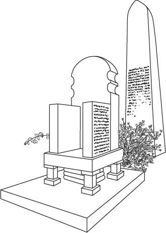
Figure 2. A reconstruction of the lost throne and stele at Adulis. This can be no more than a guess, but the inscriptions on the stele and on at least one side panel of the throne are plausible. Adapted from DAE p. 66.
Cosmas reports that the negus himself had asked the governor of Adulis to have a copy made of the inscribed texts and sent to him, and the governor entrusted Cosmas with this chore, along with another trader, who, we are told, later became a monk. Fortunately for later generations, Cosmas kept a second copy for himself and decided to include it in his book on Christian topography.
The two Greek texts at Adulis were manifestly far apart in date, but, as Cosmas copied and faithfully reproduced them, they show every sign of being authentic. They have been regularly incorporated into standard epigraphic collections alongside those texts that we know only from stones that survive today. The stele inscription is obviously the earlier one. It is a boastful account of the overseas conquests of Ptolemy III, who ruled the Hellenistic kingdom of Egypt in the third century BC. By contrast, the throne inscription, though lacking its prescript and any identification of the person who caused it to be inscribed, derives without the slightest doubt from an Ethiopian negus in the Roman imperial period. His boasts are easily a match for those of Ptolemy and were probably inspired by them. Hence the throne itself, recording the achievements of an Ethiopian ruler in conformity with the indigenous tradition of dedicated and inscribed thrones that are documented in the archaeological record, must postdate the Ptolemaic stele by several centuries at least. Whether the stele was already set up at Adulis when the throne was put there is unclear but seems likely. It is just possible that the dedicant of the throne, or someone else at a later date, had it brought to Adulis, but the obvious imitation of the Ptolemaic inscription in the Ethiopian one makes this most unlikely.
The Adulis throne, therefore, serves as an emblem of ancient Ethiopia in three distinct periods: the reign of Ptolemy III, the reign of the anonymous Ethiopian king under the Roman Empire, and, finally, the third decade of the sixth century when Cosmas transcribed the texts for a contemporary Christian king in Axum with imperialist ambitions. Cosmas reveals importantly that this king ordered the texts of these boastful inscriptions to be transcribed for him just as he was about to launch a campaign of his own against Ḥimyar on the other side of the Red Sea: “Ellatzbaas [i.e., Ella Asbeha] the king of the Axumites at that time, when he was about to go to war against the Ḥimyarites across the sea, wrote to the governor of Adulis to make an exact copy of what was written on the Ptolemaic throne and the stele, and to send it to him.” 17 Cosmas’ erroneous inference that the two objects contained parts of the same text obviously led him into the further error of thinking that the throne was Ptolemaic.
The negus was manifestly looking for precedents and inspiration for the great expedition that he would soon be launching by ship in the Gulf of Zula not far from Adulis. His overseas campaign against the Ḥimyarites in South Arabia crystalized the irredentist claims of Ethiopia to its former territory in the Arabian peninsula. It brought the Christian Ethiopians into direct conflict with its current rulers, who happened to be, at that time, Arab converts to Judaism. These Arabian Jews had recently carried out a bloody pogrom against the Christians at Najrān in their territory, and this event provided precisely the provocation that the Christian ruler in Ethiopia was looking for. He would now launch an invasion with momentous consequences for the peoples on both sides of the Red Sea, and for nations far beyond them. Byzantium and Persia were ultimately both to join the struggle.