Sullivan’s Island, Fort Moultrie, White Point Gardens, the Battery, the Old Exchange, Marion Square
Total mileage: approximately 23 miles; the walking tour covers approximately twenty-five blocks.
THIS TOUR AND THE TWO THAT FOLLOW it explore Charleston and its environs. Because the beauty of the city can best be experienced by walking, this tour and the following tour offer walks in Charleston’s historic district. If you are not exhausted when you finish this tour, you can continue with the next one and make a complete circle back to White Point Gardens.
As the colonial period gave way to the Revolution, few cities in all of America were of more importance than Charleston. When the first shots of the fight for independence were fired, Charleston was the dominant city in the South in economics, population, culture, and politics.
It is little wonder, then, that Charleston produced a wealth of statesmen and military officers who played leading roles in the Revolution. Moreover, the port city figured in the wartime strategy of both the American and British armies. Consequently, military operations in and around Charleston were intense, the two armies fighting for control of the port from the beginning to the end of the war.
The tour begins at the junction of U.S. 17 and Long Point Road in Mount Pleasant, located just across the Cooper River from Charleston. A state historical marker near the intersection calls attention to Christ Church.
Set just off U.S. 17, this stately brick edifice adorned with a cupola was constructed in 1726 to replace its wooden predecessor. During the Revolutionary War, British soldiers burned it. By the time President George Washington passed by the church on May 2, 1791, the building was nearly restored. Union troops put it to the torch during the Civil War, but once again, Christ Church was restored.
Buried at the door of the church is Charles Pinckney, the father of the man of the same name who helped draft the United States Constitution. The elder Pinckney was a wealthy planter who supported the cause of American independence until Charleston fell. Then he pledged his loyalty to the Crown.
Also located near the junction is a state historical marker for Snee Farm, the country home of the younger Charles Pinckney. To see the farm, proceed west on Long Point Road for 0.4 mile to Charles Pinckney National Historic Site.
This twenty-eight-acre site is owned and administered by the National Park Service. Archaeological work at Snee Farm has revealed the brick foundations of eighteenth-century buildings that stood on the estate. An unfurnished tidewater cottage dating from around 1822 is open for tours. It was built to replace the house constructed by Pinckney’s father in 1754. Admission to the site is free.
Charles Pinckney apologized for the condition of the place in a note addressed to George Washington just before the chief executive’s visit on the morning of May 2, 1791: “General Moultrie will request you to make a stage at a little farm of mine in Christ Church a few miles distant from hence. I must apologize for asking you to call at a place so indifferently furnished, and where your fare will be entirely that of a farm. It is a place I seldom go to, or things perhaps would be in better order.”
Charles Pinckney (1757–1824) was a member of a family that made enormous contributions to the birth and development of the independent state of South Carolina. Both of his cousins, Charles Cotesworth Pinckney (1746–1825) and Thomas Pinckney (1750–1828), rendered distinguished service as military officers and statesmen.
Charles was studying law when the Revolutionary War began. Like his father, he took up the cause of the colonies. When Charleston fell to the British, Lieutenant Charles Pinckney of the South Carolina militia was captured. Unlike his father, Lieutenant Pinckney refused to take an oath of allegiance to Great Britain, so he languished in prison for more than a year. During the latter stages of the war, the paroled soldier served in the state legislature.
Following the war, the state and nation had no more dynamic statesman than Charles Pinckney. From 1785 to 1787, he represented South Carolina in the Continental Congress. But his greatest claim to fame was his work on the United States Constitution. Pinckney claimed that he drafted a version of the Constitution from which virtually every provision that made up the final document was taken. However, when he was subsequently called upon to produce a copy of the “Pinckney draught,” he could not do so. His claim to have been the primary author of the Constitution has drawn harsh criticism from historians since that time.
His need for self-aggrandizement notwithstanding, it is highly likely that thirty or more of Pinckney’s provisions found their way into the final draft of the Constitution.
As the new republic began to function, Pinckney served the federal government as a minister to Spain and as a senator. On the state level, voters elected him governor for three terms.
From Snee Farm, continue on Long Point Road to the entrance to Boone Hall Plantation; the two are nearly across the road from each other. There is an admission charge to Boone Hall, known as “the most photographed plantation” in America. A long avenue of majestic oak trees leads to the elegant manor house. Much of what you see is the result of a reconstruction project in 1975. The main floor of the elegant Georgian structure is open to the public.
The plantation was begun in 1681 by Major John Boone, one of the first settlers in the area. Boone’s daughter was the grandmother of John and Edward Rutledge, two Charleston brothers who played leading roles in the quest for independence.
Retrace Long Point Road to U.S. 17. Turn right, proceed south for 1.2 miles to the Isle of Palms Connector, turn left, and go east for 3.9 miles to S.C. 703 on the Isle of Palms. Turn right on S.C. 703 (Palm Boulevard) and drive 1.4 miles to Charleston Boulevard, where you’ll see a state historical marker for Lord Charles Cornwallis.
On or about June 19, 1776, the man whose name is most closely associated with the British defeat in the Revolutionary War established a brigade headquarters near the present tour stop. Cornwallis, a major general in the British army, had just arrived in South Carolina with reinforcements for his immediate commander, Sir Henry Clinton. This assignment was the first major command for Cornwallis in the colonies. His camp here was part of a vast staging area established by Clinton on the Isle of Palms in anticipation of an attack on the Patriot compound at Fort Moultrie on nearby Sullivan’s Island.
Born in London into an old, established family of nobility, Cornwallis (1738–1805) was the son of the first Earl Cornwallis. After receiving a superior education at Eton, he joined the British military and rapidly advanced up the chain of command. In 1760, while serving as a lieutenant colonel, he was elected to Parliament. He took a seat in the House of Lords and received his father’s title upon the death of the elder Cornwallis in 1762.
Although Cornwallis was not a strong supporter of the British policies that led to the war with the colonies, King George III was confident in his loyalty and his military skills. Consequently, the British high command dispatched him to America in February 1776 with a force of twenty-five hundred troops. His first military action in America took place in the British assault on nearby Sullivan’s Island.
Proceed 0.1 mile west on S.C. 703 to the Colonel William Thomson Memorial Bridge over Breach Inlet, the waterway that separates the Isle of Palms from Sullivan’s Island. The bridge was named for one of the Patriot heroes at Fort Moultrie on June 28, 1776.
Cross the bridge on to Sullivan’s Island, a low-lying island that measures 3 miles long and 0.25 mile wide. Follow S.C. 703 (now Jasper Boulevard, so named for another of the heroes of the Battle of Sullivan’s Island) for another 1.7 miles to the junction with Station 22½ stop of days gone by). Turn left, drive one block south to Middle Street, turn right, and proceed 1.1 miles west to Fort Moultrie National Historic Site. Turn right into the parking lot at the visitor center.

Inside the center, you’ll find artifacts from the military installation here at Haddrell’s Point, which has helped protect Charleston in many wars. An audiovisual program shown on the hour acquaints adults and children with the storied history of the site. Atop the visitor center is an observation platform that offers a spectacular view of the fortress, the Atlantic Ocean, and the surrounding landscape that provided the setting for the great battle fought here just eight days before the Declaration of Independence was signed.
The present fort was built in 1807. It replaced two previous structures, the first of which stood during the Revolution. That original fort had walls of palmetto logs filled in with sand. It was square in design and had a bastion at each corner. When the British attacked in June 1776, approximately half of the sea face was not yet finished.
Guided tours of the present fort—located across the road from the visitor center—are offered three times each day. From its walls, visitors are afforded a view much like the one Colonel William Moultrie and the Patriot garrison had from the earlier ramparts on the summer day in 1776 when British naval and land forces launched a combined effort to take the installation.
Sir Henry Clinton and Commodore Peter Parker set sail from southeastern North Carolina with an assault armada and an expeditionary force in late May 1776. Just days later, Charlestonians were shocked to see the British fleet cross the bar. Many local residents were fearful that their main source of protection on Sullivan’s Island would provide little resistance to the mighty British warships. As one person predicted, “Those ships … will knock it down in half an hour.”
The commander of the defenses at Haddrell’s Point was more confident, even though he was forced to place most of his thirty-one big guns in the unfinished portion of the fort to protect the harbor. “We will lay behind the ruins and prevent their men from landing,” Colonel William Moultrie promised.
Moultrie’s garrison numbered 413 officers and men from the Second South Carolina and 22 officers and men from an artillery regiment. Among the fort’s junior officers was a major who had served under Moultrie in the war against the Cherokees. His name was Francis Marion.
Facing the fort in the offshore waters on the morning of June 28 were nine British men-of-war mounting three hundred guns. Across Breach Inlet on the Isle of Palms (then called Long Island), the British troops commanded by Cornwallis and others battled the heat and mosquitoes while they waited for the order to advance.
At precisely eleven o’clock, the mighty British fleet opened the battle with a hundred guns. Fiery shot and shell began raining down upon the Patriot fort from the south and southeast. But from the outset of the attack, things went awry for the British. The fort’s palmetto-and-sand construction served to cushion the impact of the projectiles; the logs did not shatter or splinter during the bombardment. Then three of the warships sailed past the fort and into the harbor in an attempt to attack from the west. Yet when they reached Middle Ground, the site where Fort Sumter was later built, they ran aground and were of no further effect.
Meanwhile, the British land force attempted to cross Breach Inlet in six or seven boats. The men encountered stiff resistance from a feisty bunch of Americans at a redoubt on the eastern tip of Sullivan’s Island. Commanded by Colonel William Thomson, the combined force of North Carolina Continentals and South Carolina soldiers offered such a withering fire that any landing attempt was impossible.
The British naval firestorm continued for more than ten hours and met with some success. From that bombardment emerged one of South Carolina’s greatest heroes of the Revolution. In the course of the battle, the fort’s towering flagstaff, which surmounted the rampart on the southeastern bastion, was knocked down by fire from the warships. Attached to the staff was the banner of the garrison—a large blue flag with a white crescent in the upper corner. Concern quickly grew among Moultrie’s men that the absence of the flag would be taken by friend and enemy to mean that the fort had struck its colors in preparation for capitulation.
No one was more alarmed than Sergeant William Jasper, who was posted on the opposite side of the fort. He pleaded with Moultrie, “Colonel, don’t let us fight without our flag.”
Moultrie was sympathetic to Jasper’s plea, but he saw little hope of once again flying the colors. “How can you help it?” he responded. “The staff is gone.”
Jasper said that he would attach the flag to a makeshift shaft. He made his way out to the beach and ran the length of the fort in the face of heavy fire from the enemy armada until he reached the fallen banner. Jasper quickly cut the flag from the damaged staff, then scaled the wall of the fort. Captain Peter Horry’s gun crew provided Jasper with a pole, to which he affixed the flag. Offering three cheers, he firmly planted the makeshift staff in the sand atop the fort, then hurried back to his post.
South Carolina had an instant hero in William Jasper. In recognition of the soldier’s gallantry, John Rutledge, the president of South Carolina, later presented his own dress sword to Jasper, saying, “Wear it in remembrance of the twenty-eighth day of June, and in remembrance of me.”
At nine-thirty on the night of the battle, the naval shelling ceased. During the course of the bombardment, the British ships had fired twenty shots to every one offered by the guns of the fort. Several hours into the battle, Moultrie had been forced to halt his big guns for lack of powder. Major Francis Marion saved the day when he and a small party of soldiers left the fort and commandeered several hundred pounds of the badly need commodity.
Almost as soon as the bombardment ended, the British fleet prepared to withdraw. American losses in the fort amounted to forty killed and wounded. British losses—most of them aboard two ships—were much higher. From the deck of the British flagship, an eyewitness observed the misery on the other ships: “I was on board the Bristol during the action and suffered much from the sight of so much slaughter. I am perfectly satisfied with what I have seen of civil war and devoutly wish that omnipotence would arrest the progress of the destroying angel and say it is enough.” The British were forced to abandon and set fire to the Actaeon, one of the finest frigates in the Royal Navy.
By first light on June 29, the fleet withdrew. The crude fort here thus saved Charleston and thwarted the first British campaign in the South. As a result, South Carolina remained relatively free of military operations for three years, and Charleston remained open to vessels bringing the supplies used by American armies in the North.
It did not take long for the fort to acquire a new name. Newspaper editor John Wells reported on August 2, “We hear that the fort on Sullivan’s Island will be in the future called Fort Moultrie, in honor of the gallant officer who commanded there on the memorable 28th of June 1776.” Indeed, since the brilliant victory here in the early days of the fight for independence, the military installation has been known by that name.
Not only did the Battle of Sullivan’s Island produce a state hero in Sergeant Jasper, but it gave America an acclaimed national hero in William Moultrie. Born in Charleston two years after his father, a prominent physician, came to South Carolina, Moultrie (1730–1805) grew up in a world of affluence. His first military experience came in the 1760s in the colonial campaigns against the Cherokees. He emerged from the Indian wars as one of the most respected soldiers in South Carolina.
On two occasions, voters elected Moultrie to the Continental Congress, but he declined the seat, choosing instead to serve on the battlefield. He accepted a commission as commander of the Second South Carolina at the onset of the Revolution. A year after his heroics on Sullivan’s Island, Congress rewarded him with a promotion to brigadier general in the Continental Army.
On February 3, 1779, General Moultrie led the Americans to victory at Beaufort. When the British began their movements against Charleston in the spring of 1780, it was General Moultrie who prepared the city’s defenses. Unfortunately, by that time, the fort that bore his name had fallen into disrepair. When Charleston fell, Moultrie was taken prisoner. He was exchanged in February 1782. On October 15 of that year, he was promoted to major general.
Moultrie had three brothers who served in the war. Thomas Moultrie, who was killed in action near Charleston on April 24, 1780, and Andrew Moultrie were both Patriot captains. However, the third brother, John Moultrie, was a Loyalist soldier.
Following the war, South Carolina benefited from the political leadership of William Moultrie. He served as a state legislator, as lieutenant governor, and as governor for two terms.
Retrace your route to the junction with S.C. 703. Turn left and follow S.C. 703 as it winds north and then east for 2.9 miles to U.S. 17/U.S. 701 Business (Coleman Boulevard) in old Mount Pleasant. This coastal town traces its roots to a settlement begun by Florentia O’Sullivan, the Irish soldier for whom nearby Sullivan’s Island was named.
Follow U.S. 17/U.S. 701 Business for 0.9 mile to Mary Hibben Street. Turn left and follow Mary Hibben Street for four blocks to its terminus overlooking Charleston Harbor. Located nearby at 111 Mary Hibben is the two-story Hibben House. Constructed in 1755, it was used twenty years later by Colonel Moultrie in his defense of Charleston Harbor. In 1775, he hastily constructed a rampart in the front yard here and dispatched two British warships that had made an appearance in Charleston.
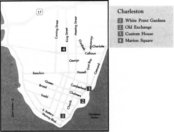
Return to U.S. 17/U.S. 701 Business and follow it for 1.9 miles north-east to the junction with U.S. 17/U.S. 701. Turn left and drive 2.3 miles to Meeting Street in Charleston, the capital of colonial South Carolina; en route, you will cross the historic Cooper River Bridge. Turn left on Meeting and proceed south all the way to South Battery Street on the historic waterfront. Leave your car at White Point Gardens, a magnificent municipal park.
White Point Gardens is an excellent place to start a walking tour of the city where much of the great drama of the Revolutionary War was played out. Beautifully landscaped with live oaks and palmettos, the seven-acre park is dotted with a variety of interesting memorials, statues, and monuments. Sergeant Jasper and the defenders of Fort Moultrie are honored here with a spectacular memorial surmounted by a soldier holding a South Carolina flag. It was erected in 1876 as part of the centennial celebration of the American victory at Sullivan’s Island.
White Point Gardens is located along the Battery, the high walls overlooking Charleston Harbor. From this historic spot, you can enjoy a spectacular view of the harbor at the confluence of the Ashley and Cooper Rivers. Few harbors in all the world have been witness to more important and dramatic events. For example, in the distance, you can see Fort Sumter, where the Civil War began; that nineteenth-century fortification was named for General Thomas Sumter, one of the great Revolutionary War heroes of South Carolina.

You are standing at a place long known as Oyster Point. It was here that the historic city took root. Originally an English settlement known as Charles Towne Landing, the community was established 3.5 miles up the Ashley River in 1670. Over the next decade, however, settlers discovered that Oyster Point was a better location because of its potential as a port and its defensive capabilities. Surveys were conducted to lay out a town site. In 1680, Charles Towne was born here. It became the seat of South Carolina government, a distinction it would hold for more than a century. The name was changed to Charlestowne in the early eighteenth century. The final e was not dropped until the end of the Revolutionary War. Both city and county were named for King Charles II of England.
By the late colonial period, Charleston was the most important city south of Philadelphia. In 1772, it boasted a population of nearly twelve thousand, making it the fourth-largest city in British North America. Only Philadelphia, New York, and Boston claimed more citizens.
As the first seeds of the Revolution were being sown, Charleston was at the forefront of the independence movement. On October 18, 1765, when the British ship Planters Adventure sailed within sight of the place where you now stand, it brought the first shipment of the new stamps that were to be used when the Stamp Act went into effect on November 1. Over the next nine days, the city was the scene of wild protests and demonstrations. Mobs sought out citizens suspected of being sympathetic to the Crown. Local Stamp Act officials were pressured to resign their positions. Meanwhile, several Charlestonians, including John Rutledge and Christopher Gadsden, were representing South Carolina at the Stamp Act Congress, where they joined in a petition seeking repeal of the unpopular legislation. News that the Stamp Act had been repealed reached Charleston on June 4, 1766—which, ironically, was the birthday of King George. Jubilant citizens took to the streets.
From stamps, the festering crisis with Great Britain moved to tea. In March 1774, Parliament enacted the Boston Port Act, which closed the Massachusetts city to all shipping until local citizens made restitution for the tea destroyed during the Boston Tea Party. When word of that punitive legislation reached Charleston on May 31, the citizens were outraged. A local newspaper decried the act as “the crudest Policy that ever disgraced a British Senate.”
Anxious to aid their fellow Americans, the people of Charleston rushed shipments of rice to Boston. On June 27, the first of many relief ships set sail from the harbor.
In 1778, a committee in Boston reported that the city had received more supplies and money from South Carolina than any other colony during the embargo.
It was Charleston that led South Carolina along the road toward independence. As you stroll the city, you will see many of the important Revolutionary War sites in one of the most historic cities on the North American continent. You will also partake of the nation’s most beautifully preserved city.
Walk north on East Battery for two blocks to where it becomes East Bay Street. This was the southeastern limit of the walled city that was colonial Charleston. A wall was constructed around the city in 1704 to provide protection against attacks from the Spanish settlement in Florida. The wall was removed in 1720.
Continue two blocks north to the Thomas Pinckney House, at 57 East Bay. Constructed in 1783, this much-altered three-story house with a second-floor wrought-iron balcony was owned by Major General Thomas Pinckney, a leading South Carolinian of the Revolutionary War era. It served Pinckney as a rental property. He lived at 14 George Street after the war; his life and contributions to the cause of independence will be chronicled at that site, which is covered in Tour 5, pages 68–69.
Continue north for two blocks to 76-80 East Bay. This is the oldest apartment building in the United States. It was constructed in 1800 by General Arnoldus Vanderhorst, the mayor of Charleston when George Washington visited the city in 1791 and the governor of South Carolina from 1792 to 1794.
Located at 83 East Bay, the William Stone House is a four-and-a-half-story dwelling constructed by Stone, a Tory merchant. Seeking safety, he fled to England during the Revolution. A fire gutted the structure in 1778. It was subsequently rebuilt.
Continue north to the Inglis Arch House, located at 91 East Bay. This structure was erected in 1798 by Leger and Greenwood, a local mercantile firm that specialized in the importation of tea before the Revolution. It was the stock of Leger and Greenwood that Charleston Patriots used for their own tea party in 1775.

Walk north for three blocks to the Old Exchange, located at 122 East Bay at the junction with Broad Street. This is one of the outstanding jewels in Charleston’s treasure chest of history and architecture. Open to the public as a museum, this magnificent building was constructed between 1767 and 1771 as a result of an appropriation by the colonial assembly for an “Exchange and Custom House and a new Watch House.”
History abounds both outside and inside this monumental structure, which rises two stories above a massive arcaded basement.
As you ascend the steps to the entrance, consider the scene at this very spot on March 28, 1776. A large crowd assembled in front of the building in anticipation of a public announcement by the Second Provincial Congress, which had been hard at work on a constitution for the colony. Drafted by a committee of eleven distinguished men that included three future signers of the Declaration of Independence and two future signers of the United States Constitution, the document was the second constitution adopted by an American colony and the first to establish a complete system of government. When it was adopted in Charleston that month, it was officially termed a temporary document until “an accommodation of the unhappy differences between Great Britain and America can be obtained.”
Christopher Gadsden, among the hottest of the firebrands at the Second Provincial Congress, suggested that the constitution should declare South Carolina independent, but the majority of his colleagues were not willing to go that far. However, one of the draftsmen, Henry Laurens, told an English friend that the document could serve as the basis of government for the independent state of South Carolina if a formal break between Great Britain and the colonies were declared.
On March 28, a delegation emerged from the Old Exchange, and the constitution was read publicly for the first time. John Rutledge was declared president of the colony. As soon as the last word was proclaimed, the crowd rejoiced and artillery pieces and ships in the harbor fired celebratory salutes.
Inside the grand building, you can walk in the very rooms where the leading citizens of Charleston met in late 1773 and early 1774 to protest the Tea Act. Indeed, tea seized by the Crown for nonpayment of duties was stored in the building.
A visit to the restored basement is a must. In a sealed secret vault here, William Moultrie and his men hid ten thousand pounds of gunpowder they had taken from the Powder Magazine on Cumberland Street. After the British captured Charleston, they used the Old Exchange as their headquarters, but they never discovered Moultrie’s secret cache.
During the British occupation of the city, the basement was used as a dungeon for the “most wanted” political and military prisoners. Among the captives held here were signers of the Declaration of Independence. Famous martyr Isaac Hayne was led from the dungeon to the gallows. (For information about Hayne, see Tour 7, pages 102–3.)
After the successful conclusion of the war, the United States Constitution was ratified here by South Carolina in 1788. President Washington was entertained in the Great Hall during his visit in 1791, as was Lafayette when he came to Charleston in 1825.
An admission fee is charged for this most historic of buildings.
Proceed north on East Bay for two blocks to Cumberland Street. Here at 200 East Bay stands one of the finest buildings of the city—the United States Custom House. It is located on the site of Craven’s Bastion, a portion of the wall that surrounded colonial Charleston.
Continue one block to the Robert Primerose House, at 332 East Bay. This early-nineteenth-century brick dwelling stands on the site of the residence of Christopher Gadsden, one of the most illustrious leaders of the Revolution in South Carolina; Gadsden’s career is detailed in Tour 5, pages 71–72.
Walk to the Blake-Grimke House, at 321 East Bay. Erected around 1789, this two-story frame dwelling was once occupied by the widow of Arthur Middleton, a signer of the Declaration of Independence.
Continue to the Gadsden-Morris House, located at 329 East Bay. Built around 1800, this is one of the tallest Federal-style houses in the city. Constructed by Thomas Morris, the son-in-law of Christopher Gadsden, it stands on land once owned by the Revolutionary War hero. Colonel Elnathan Haskell, another hero of the Revolution, was a subsequent owner of the dwelling.
Continue north on East Bay for two blocks to Calhoun Street. Turn left and walk one block west to Alexander Street to see the Gadsden-Dewees House, located at 80 Alexander. Built around 1800, this handsome two-story house stands on land owned by Christopher Gadsden during the Revolutionary War era.
A plaque on the house notes that the Liberty Tree once stood here. Described as a “noble live oak,” the tree was dedicated to liberty by the John Wilkes Club of Charleston in 1766. That organization later changed its name to the Palmetto Society. Its leader, Christopher Gadsden, used the tree as the setting for his first appeal that South Carolina be declared independent from Great Britain. Because of its significance, the British chopped the tree down during their occupation of the city.
Continue west on Calhoun for three blocks to King Street to visit Marion Square, a sprawling municipal park that was established as a parade ground in 1822. Named in honor of the legendary Swamp Fox, the square lies in the shadow of the historic and recently refurbished Francis Marion Hotel. Numerous monuments and memorials of varying sizes and shapes pay tribute to famous South Carolinians; one of the monuments honors General Marion.
Of special interest at Marion Square is the small fenced enclosure that holds the remains of the tabby fortifications built to protect Charleston during the Revolutionary War.
By the early spring of 1780, the British high command was convinced it could wait no longer to make an all-out attempt to take Charleston, one of the most vital ports to the American cause. Near the end of March, Sir Henry Clinton moved his army within striking distance of the fortifications here. Less than ten days later, Vice Admiral Marriott Arbuthnot sailed his fleet into Charleston Harbor past Fort Moultrie, which, like Fort Johnson, the other defense work protecting the water approaches, had been allowed to fall into disrepair.
With the harbor secure, Clinton was confident he had closed all the city’s links to the outside world. On April 10, the British dispatched a surrender demand to the Americans in the surrounded city. When the demand was refused, the British promptly laid siege. Clinton later noted that capturing “all the rebel corps in Charleston had been from the first a very principal object with me, as I saw the reduction of the rest of the province in great measure depended upon it.”
Commanding the American defense of Charleston was Major General Benjamin Lincoln, a native of Massachusetts. Though Lincoln would soon surrender the city, George Washington never lost confidence in him. At Yorktown in October 1781, Washington selected Lincoln to accept the British sword of surrender.
When Clinton appeared with his army, Lincoln had approximately 3,600 soldiers with whom to defend Charleston. Some 2,000 of them were militiamen from the two Carolinas. Before the noose was tightened around the Americans, 2,150 reinforcements (including almost 1,500 Continentals) reached the city. Some historians have speculated that Clinton allowed these soldiers to enter the city in order to fatten his prize when he ultimately claimed it.
Sporadic fighting took place along the city’s fortifications throughout the siege. By May 6, the beleaguered Americans had but a week’s rations. At sunrise on May 8, Lincoln received a summons for unconditional surrender. Negotiations began, but little progress was made.
At two o’clock in the morning on May 11, Christopher Gadsden, a spokesman for the leading citizens of Charleston, implored Lincoln to surrender on the best terms he could get. A day later, the siege ended when Lincoln capitulated. Under the terms of the accord, the city, every soldier defending it, all military stores and defense works, and all shipping were handed over to the British conquerors.
At eleven o’clock in the morning on May 12, the vanquished Americans, led by the Continentals, marched past the present tour stop. They were not allowed to fly their colors or play their favorite military airs. Instead, the terms of surrender required the drummers to pound out the demeaning “Turk’s March.”
To bring Charleston to its knees, Clinton employed 12,700 soldiers and 4,500 sailors. His losses in killed and wounded amounted to no more than 265.
Lincoln lost approximately 230 in killed and wounded. But 5,500 Americans were taken prisoner. Not until Stonewall Jackson’s capture of Harper’s Ferry more than eighty years later would more American soldiers be captured in a single day.
The tour ends here. Return to East Bay Street and follow it south to White Point Gardens to get back to your car. Or if you wish to combine this tour with the following one, turn right on King Street, walk two blocks to John Street, turn right again, and proceed one block to Meeting Street and the Charleston Museum.