
The Savannah River Tour, Part 1
Barnwell, Sumter National Forest, Fort Galphin, Aiken, North Augusta
Total mileage: approximately 117 miles.
THIS TOUR AND THE FOLLOWING two tours cover an area on the western border of South Carolina where the mighty Savannah River creates a natural boundary with Georgia. After Savannah fell to the British on December 29, 1778, South Carolina was under constant threat of invasion. The area encompassed by these three tours provided South Carolina’s front line of defense against British attack from Georgia.
The tour begins at the Salkehatchie River on U.S. 64 approximately 3 miles west of Barnwell, the county seat of Barnwell County. Vince’s Fort once stood in this vicinity. That small American installation was abandoned by its eighty-man garrison prior to the arrival of Colonel Hezekiah Williams and his band of Tories on October 28, 1781. Williams torched the outpost.
Proceed east on U.S. 64 for 3 miles to Hagood Avenue in Barnwell. Turn left and drive five blocks east to S.C. 3 (Marlboro Avenue). Here stands the Barnwell County Museum, which holds a treasure trove of relics and information related to the American Revolution and other periods of local history.
Turn left on S.C. 3, drive north for 12.2 miles to S.R. 6-32, turn right, and proceed 0.2 mile to S.R. 6-358. Turn right and go 0.2 mile south to Healing Springs Baptist Church.
Established in 1772, the Healing Springs congregation is the oldest in Barnwell County. It is now housed in a white frame building erected in the mid-nineteenth century. Near the church are the still-flowing artesian wells from which the church takes its name.
People continue to visit these springs to drink from them and to carry their water home. A centuries-old legend has it that the waters have great healing powers. During the Revolutionary War, soldiers who were too badly wounded to be transported were left near the current tour stop. Several weeks later, when their commander returned, he was shocked to find that his men had fully recovered after availing themselves of the waters.
Retrace your route to the junction of S.R. 6-32 and S.C. 3. Proceed west on S.R. 6-32 for 3.8 miles to S.C. 37. Turn right, head north for 3.7 miles to S.C. 39, turn right again, and drive northeast. It is 8 miles to the Aiken County line; en route, you will pass over the southern fork of the Edisto River and briefly enter Orangeburg County.
From the Aiken County line, continue on S.C. 39 for 0.6 mile to S.C. 394 in Salley, named for a family that settled here in the eighteenth century. Turn left on S.C. 394 and drive 1.2 miles west to the John Town Memorial, located at the site of the Battle of John Town.

Here, on the southern banks of Dean Swamp, a force of Patriots commanded by Captain Michael Watson and Captain William Butler was ambushed by a band of Tories on May 4, 1782. Watson and Miller had been sent out to find the Tories, who were considered a threat to two nearby bull pens where the Americans were holding British and Tory prisoners.
Though Watson and a junior officer were killed in the ambush, the Patriots pushed forward. After reinforcements arrived, they routed the Tories commanded by Major William Cunningham and drove them into the nearby swamp.
Continue on S.C. 394 for 8.8 miles to S.C. 302, turn right, and proceed 0.6 mile north to S.R. 2-53 at Kitchings Mill. Turn left, head south for 7.2 miles to U.S. 78, turn left again, and drive 0.3 mile southeast to S.R. 2-54 in Windsor. Turn right on S.R. 2-54 and follow it for 6.4 miles to U.S. 278, then turn right and drive 9.3 miles northwest to S.C. 19; en route, you will pass through the edge of the Savannah River Plant. Continue on U.S. 278 for another 2.3 miles to S.R. 2-62. Turn left and drive southwest for 5.9 miles. You will pass into Sumter National Forest, named for General Thomas Sumter of Revolutionary War fame (see Tour 20, pages 280–81).
Turn right at the junction of S.R. 2-62 and S.R. 2-5. Drive northwest for 2.2 miles to the junction with an unimproved road. Turn left and follow that road west for 2.3 miles to the Savannah River at Silver Bluff. A Revolutionary War fort that bore two names once stood at this site.
To the Patriots, it was Fort Galphin, since the stockade surrounded the home of George Galphin, a former deputy superintendent of Indian affairs who had cast his lot with the cause of independence. The British, who commanded the outpost for much of the war, gave it a name that suggested invincibility—Fort Dreadnought. In May 1781, the Patriots showed the British just how wrong they were.
At that time, the fort was manned by two companies of soldiers and was defended by heavy guns overlooking the river. Colonel Elijah Clarke, a Patriot from Georgia, learned that several boatloads of supplies and ordnance (the king’s annual gift to the Indians of South Carolina) were being shipped up the river near the fort. Clarke’s forces attacked the British boats and forced them into port at the fort.
British regulars used the fort’s cannon to keep Colonel Clarke at bay.
Day by day, additional partisans arrived to support Colonel Clarke. Among the new arrivals was General Andrew Pickens, who immediately invested two forts across the river near Augusta, so as to cut off assistance to the fort here at Silver Bluff. Then, on May 21, Lieutenant Colonel Henry Lee, in high spirits following his recent victory at Fort Granby (see Tour 21, pages 296–97), made his way to the Savannah River with some of General Sumter’s men. Lee promptly dispatched a portion of his vaunted legion under the command of Major John Rudolph to aid Colonel Clarke in the reduction of Fort Dreadnought.
Rudolph and Clarke used a bit of trickery to accomplish their objective. While hiding most of his Continentals, Rudolph sent a small force in front of the fort as a decoy. Falling for one of the oldest of military tricks, the fort’s defenders rushed out en masse to pursue Rudolph’s bait. When the gates of the fort were opened, Clarke’s militiamen and the regulars from Lee’s army poured in to surprise and capture the unsuspecting enemy soldiers therein.
Once the pursuers outside the fort discovered that their post had been captured, they capitulated to Clarke and Rudolph. Among the 126 prisoners taken, 70 were British regulars who would be sorely missed in the subsequent defense of Augusta. Included in the booty captured by the Americans were blankets, foodstuffs, clothing, medicines, weapons, munitions, and other provisions they desperately needed.
Return to the junction with S.R. 2-5. Turn left, proceed 2.2 miles north to S.R. 2-32, turn left again, and head east for 1.8 miles to U.S. 125/S.C. 302. Follow S.C. 302 for 11.9 miles east to Powderhouse Road in Aiken, the seat of the county of the same name. Turn left, drive 1.5 miles to South Boundary Street, turn left again, and go west for eleven blocks to U.S. 19 (Whiskey Road). Turn left and proceed one block south to the Aiken County Historical Museum, located at 433 Newberry Street.
Housed in a twentieth-century mansion called Banksia, the museum offers a wide variety of exhibits related to the early history of Aiken County. Standing on the museum grounds is the Eagle Log Cabin, constructed around 1808. It is believed to be the oldest building in the county.

From the museum, turn around and proceed north on U.S. 19 for five blocks to U.S. 1. Turn right and drive west for 13.1 miles to S.R. 2-365. Turn right, head north for 1.7 miles to S.R. 2-68, turn left, and proceed 1.1 miles south to S.C. 230. Turn left and follow S.C. 230 for 0.9 mile to the state historical marker for Martintown Road.
This historic road followed the route of an old Indian path. Abraham Martin, a descendant of Irish immigrants who came to America in the seventeenth century, settled here before the Revolution; Martintown Road took its name from his family. Martin served under George Washington in the French and Indian War. He subsequently married Elizabeth Marshall, the aunt of Chief Justice John Marshall. They were the parents of eight sons, all of whom fought in the Revolution. Martintown Road was heavily used by both sides during the war.

Proceed two blocks north on S.C. 230 to U.S. 25 Business (Georgia Avenue) in the town of North Augusta. Turn left, drive 0.6 mile to Buena Vista Avenue, turn right, and proceed 0.6 mile to Georgetown Drive. Turn left and go 0.3 mile to River View Park.
This municipal park affords an excellent setting from which to view the Savannah River near where President George Washington and his horse crossed a newly completed eight-hundred-foot bridge on his return from Georgia to South Carolina. Here, on the eastern banks of the river, he was greeted by an artillery salute.
Near the park stands a state historical marker honoring Samuel Hammond (1757–1842), whose grave was originally located on the banks of the river near the current tour stop. Born in Virginia, Hammond had established a solid reputation as an Indian fighter by the time he moved to the Edgefield District of South Carolina. During the Revolution, he attained the rank of lieutenant colonel and commanded state troops with great skill in many battles, including those at Hanging Rock, Musgrove’s Mill, Kings Mountain, Blackstock’s, Cowpens, Guilford Courthouse, Augusta, and Eutaw Springs. Hammond’s existing grave site is the next stop on this tour.

Retrace your route to the intersection of U.S. 25 Business and S.C. 230. Turn left on S.C. 230 (Martintown Road) and drive nine blocks to the Charles Hammond House, located at 908 West Martintown.
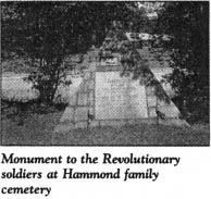
Constructed around 1790, this once-grand two-story frame dwelling was undergoing restoration at the time of this writing. Adjacent to it is the Hammond family cemetery, the burial site of Colonel Samuel Hammond. A granite monument in the shape of a pyramid pays tribute to Colonel Hammond and two of his kinsmen, Colonel LeRoy Hammond, Sr., and Captain LeRoy Hammond, Jr. All three men fought for the American cause in the Revolution.
Following the war, Samuel Hammond represented South Carolina in Congress. After the United States completed the Louisiana Purchase, he was appointed by President Thomas Jefferson as colonel-commandant of the St. Louis District. In 1813, he was elected the first president of the Missouri Territory Council.
The tour ends here in North Augusta. If you wish to explore the area further, continue northwest on S.C. 230 for 3.2 miles to the Edgefield County line, where the next tour begins.