
The Redcoats, Tories, and Indians Tour, Part 2
Tamassee, Keowee-Toxaway State Park, Greenville County, Travelers Rest, Paris Mountain State Park, Laurens County, Waterloo, Hayes Station Massacre site
Total mileage: approximately 183 miles.
THIS TOUR WINDS THROUGH the mountainous area of northwestern South Carolina that was the frontier in Revolutionary War times. Here, citizens dedicated to independence did battle with three enemies: British regulars, Tories, and Cherokees. To view the entire seven-county area, you can combine this tour with Tours 12 and 14.
The tour begins at the junction of S.C. 11 and S.R. 37-172 at Tamassee. Proceed north on S.C. 11 to the state historical marker for the Cherokee Path.
Here, S.C. 11 follows the historic trading path of the Cherokee Indians. During the Cherokee War and the Revolutionary War, this was an important military route because it linked Fort Loudoun on the Little Tennessee River with Fort Prince George on the Keowee River. Andrew Williamson used the route in his reprisals against the Indians in 1776.
Follow S.C. 11 for 4.8 miles to the Keowee River, where you’ll enter Pickens County. Continue east on S.C. 11 for 1.2 miles to S.C. 133 and the entrance to Keowee-Toxaway State Park.
The park is located on Lake Keowee. It rests on land that was once the capital of the Lower Cherokee nation. An interpretive center and a boardwalk with kiosks and exhibits relate the history of the Cherokee Indians.
As late as 1782, General Pickens and a force of four hundred militiamen were working in this area to destroy Indian villages in order to lessen the threat of attacks against settlers.
Continue east on S.C. 11 for 19.4 miles to the Greenville County line. Named for General Nathanael Greene, the man who conducted mop-up operations in South Carolina during the last two years of the war, the county was created in 1786.
From the county line, follow S.C. 11 for 4.9 miles to S.R. 23-175, turn right, and drive south for 3.9 miles to S.C. 288. Turn left and head east for 1.7 miles to U.S. 276. Proceed south on U.S. 276 for 4.9 miles to U.S. 25 in Travelers Rest.
This small town is the heart of the area where a local Tory known as Bloody Bill Bates carried on a reign of terror against local settlers in the months before the Battle of Kings Mountain. Encouraged by British authorities, Bates and his cruel band of Indians and Tories roamed the northern portions of what are now Greenville and Spartanburg Counties in search of homes and farms left defenseless by men who were away fighting with Greene and Pickens.
On one occasion, they called at the home of old Mr. Motley on Motlow’s Creek in Spartanburg County. Bates promptly executed the old man and several bystanders. Motley’s son was taken prisoner and informed that he, too, was going to die. The young man was ordered to remove his clothes and his knee breeches with the silver buckles because Bates did not want them bloodied. As Bates stooped over to remove the buckles, Motley, fully aware that his fate was sealed, lurched forward, knocked down the men encircling him, and outran his adversaries.
Turn left on U.S. 25, drive north for 0.6 mile to S.R. 23-563, turn left again, and proceed east for 2.6 miles to the entrance of Paris Mountain State Park.
Named for the mountain that towers a thousand feet above the nearby city of Greenville, the park encompasses the peak and the surrounding acreage that was once the estate of Richard Pearis. The name of the mountain is a corrupted version of his name.
Pearis, the first white settler in what is now Greenville County, was a gallant soldier for the British cause in the French and Indian War. He is said to have been the first British soldier to enter Fort Duquesne.
When the fight for American independence began, both the Americans and the British sought the support of Pearis. Initially, he pledged his loyalty to the colonies, but he was greatly disappointed at the rank he was offered in the Patriot army. Consequently, he cast his lot with the Crown.
In 1776, during Pearis’s nine months of captivity at a Charleston prison because of his loyalty to England, his extensive plantation here, known as Great Plains, was destroyed by Colonel John Thomas and his Spartan Regiment. Today, nothing remains of the vast estate, which included a lavish home, a mill, a trading post, and storage facilities.
Following his release, Pearis rose to the rank of colonel in the Loyalist army. It was he who received the surrender of Andrew Pickens after the fall of Charleston.
Following the war, the British government rewarded Pearis for his loyalty with a grant of land in the Bahamas.
Return to U.S. 25. Turn right and drive south for 1.5 miles. Near this site stood the Rock House, the home of Billy Young. True to his name, Young was a boy hero of the Revolution. As a member of General Marion’s army, he was known as the “Terror of the Tories.” By war’s end, he was but twenty-three years old.
Continue south on U.S. 25 for 31.1 miles to S.R. 23-456. Turn left, drive east for 2.4 miles to S.R. 23-68, turn right, and go south for 3.1 miles to S.R. 23-69. Continue on S.R. 23-68 for 1.6 miles to the Sullivan Cemetery, also known as the Grove Cemetery.
This was the site of one of the oldest Methodist churches in Greenville County. Established in 1790, the congregation later moved to another site. However, the old cemetery survives today. In it are the graves of numerous Revolutionary War soldiers. A state historical marker for the cemetery is located near the bridge over the Reedy River about 0.5 mile south.
Turn around at the cemetery and proceed 1.7 miles northwest on S.R. 23-68 to S.R. 23-455. Turn right, drive north for 5.8 miles to S.R. 23-154, turn right again, and go northeast for 0.4 mile to S.R. 23-55. Turn left, drive north for 0.4 mile to S.R. 23-451, turn right, and go 0.4 mile to Fairview Presbyterian Church.
Organized in the aftermath of the Revolution by local Scots-Irish families, the church stands beside an expansive cemetery that holds the graves of many local men who fought for independence. A state historical marker detailing the history of the church and cemetery is nearby.
Return to the junction with S.R. 23-55. Turn right and proceed north for 1.2 miles to S.C. 418, where you’ll see a state historical marker for the Battle of Great Cane Brake.
To visit the site of that 1775 battle between Patriots and Tories, continue north on S.R. 23-55 for 1 mile to S.R. 23-542, turn left, and drive west for 2.4 miles to S.R. 23-12 (Harrison Bridge Road). Turn left and head south for 0.5 mile to the battle site. A monument stands on the left side of the highway on private property. It was here on the banks of the Reedy River that Colonel William Thompson won the final battle of Colonel Richard Richardson’s Snow Campaign in December 1775.
Following the clash between Patriots and Tories at Ninety Six on November 17, Colonel Richardson moved into the frontier in search of Patrick Cunningham and his band. Disregarding the truce arranged at Ninety Six, Richardson boldly announced on December 8, “I am now come into these parts, in the name and behalf of the Colonies to demand of the inhabitants, the delivery up to the bodies of the principal offenders herein, together with the Said ammunition and full restitution for the ravages committed, and also the arms and ammunition of all the aiders and abettors of those robbers, murderers, and disturbers.” His army of several thousand Patriots fanned out in the Upcountry, seeking out Loyalists and neutralizing their influence.
This successful expedition was brought to a close here at the Battle of Great Cane Break on December 22. By that time, the organized Tory resistance had been reduced to Cunningham’s two hundred men. Colonel William Thompson of Richardson’s command caught Cunningham’s army at the current tour stop about dawn. Although Cunningham and a few of his followers escaped, most of his men were taken prisoner.
Following the battle, Loyalist strength in the back country was diluted. It did not grow again until the fall of Charleston four and a half years later. As Richardson’s army marched away, a winter storm dropped fifteen inches of snow on the victorious Patriots. As a result, the expedition was thereafter known as the Snow Campaign.
An abundance of canebrakes still grows at the battle site.
Retrace your route to S.R. 23-55. Turn right and drive 1 mile to the Laurens County line, where the route becomes S.R. 30-54. Established in 1785, Laurens County was named for Henry Laurens, the distinguished South Carolina statesman who served as president of the Continental Congress. (For more information on Laurens, see Tour 3, page 41–42.)
Proceed southeast on S.R. 30-54 for 10.4 miles to S.C. 252, turn left, and drive 4.7 miles to S.R. 30-398. Turn right and go 2 miles to the state historical marker near the site of Lindley’s Fort.
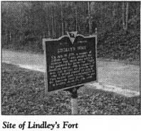
On July 15, 1776, many local settlers were crowded in the frontier fort that stood nearby when it was suddenly attacked by a force of 88 Indians and 102 Tories painted and dressed like Indians. Unbeknownst to the attackers, a company of 150 Patriot militiamen under Major Jonathan Downs had arrived at the fort the previous night. Downs and his soldiers beat back the assault. The victory by the Patriots here influenced many local residents to take up the cause of independence.
The reverse side of the historical marker pays tribute to Major Jonathan Downs. As a statesman, Downs served in the First and Second Provincial Congresses. As a soldier, he distinguished himself both here and at Hayes Station (visited later in this tour).
Retrace your route to S.R. 30-54, turn right, and proceed southeast for 2.9 miles to S.R. 30-36. Turn right and drive south for 3.9 miles to S.R. 306; en route, you will pass the Reedy River. Turn south on S.R. 30-6. Almost as soon as you turn, you will notice Old King’s Chapel Methodist Church. Organized in the eighteenth century, this church served as a muster ground during the Revolutionary War.
In this area stood Ridgeway’s Fort, a small structure comprised of two blockhouses and garrisoned by thirty Patriots. On September 5, 1781, Bloody Bill Cunningham and his force attacked and captured the fort. Two officers and eight privates were killed by Cunningham’s men after the surrender.
Follow S.R. 30-6 for 4.6 miles to S.R. 30-54, turn right, and drive 6.8 miles south to U.S. 221 at Waterloo. Turn right and proceed south for 2.1 miles to S.R. 30-149, where you’ll see a historical marker for Rosemont Manor.
To visit the site of the manor of Anne Pamela Cunningham, the lady who saved George Washington’s home, turn right on S.R. 30-149, proceed south for 0.8 mile to S.R. 30-221, turn left, and go 1.7 miles to the granite monument that marks the spot where Rosemont Manor stood.
Built in 1769 by Patrick Cunningham on land granted to him by King George III, Rosemont Manor was one of the most stately homes in the South Carolina Upcountry. During the war, the Cunningham family was loyal to the Crown. As a result, some of its members lived in temporary exile in the West Indies.
Ironically, it was a daughter of this Loyalist family who began the drive to preserve Mount Vernon, the home of George Washington. Anne Pamela Cunningham was born at Rosemont Manor and was an invalid for much of her childhood. But as an adult, she founded and was the first regent of the Mount Vernon Ladies’ Association of the Union. In 1858, that organization purchased Mount Vernon and made it into a national shrine.
Retrace your route to U.S. 221. Turn left, proceed north for 1.6 miles to S.R. 30-19 on the southern side of Waterloo, turn right, and go 4.3 miles southeast to the junction with S.C. 39 and S.C. 72 at Cross Hill. Drive south on S.C. 39 (North Main Street) for 0.2 mile to Puckett Ferry Road.
Located at this junction is the J. H. Coleman House. Built in the eighteenth century as an inn and stagecoach stop, it stands near the crossroads where the town of Cross Hill was established. When a hurricane hit the Upcountry during the Revolutionary War, a group of British officers took safety here while on their way to the star fort at Ninety Six.
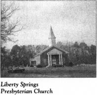
Continue south on S.C. 39 for 0.3 mile to South Liberty Street, turn right, and proceed 0.1 mile to Liberty Springs Presbyterian Church, located at the end of the road. This church was organized around 1786 and named for a local encampment of the Sons of Liberty. The founding meeting of the Mount Vernon Ladies’ Association was held in the church building that preceded the existing structure. Local Patriots are buried in the adjacent cemetery.
Return to S.C. 39, turn right, and drive south for 0.5 mile to S.C. 560. Turn left and proceed east for 7.1 miles to S.C. 56, where you’ll see a monument for the Hayes Station Massacre.
Located on land owned by the Laurens County Historical Association, the monument stands on the site of a small American post known as Hayes Station. Named for its commander, Colonel Joseph Hayes, the post was garrisoned by forty Patriot soldiers.
In November 1781, following the Cloud’s Creek Massacre (see Tour 21, pages 293–94), a communiqué was dispatched to Colonel Hayes informing him that Bloody Bill Cunningham was on a rampage in the area and ordering him to abandon his base.
Hayes had just returned from a scouting expedition on which he had found no evidence of Cunningham or his men. As a consequence, he decided to disregard the order and remain at his post. Word of his decision was sent to a nearby American installation in the event that aid might be needed.
Shortly thereafter, a group of Cunningham’s marauders appeared at Hayes Station with a warning that if any shots were fired from the fort, all the Patriots there would die. No sooner had the words been spoken than a blast from a Patriot gun felled one of the Tories.
Presently, Bloody Bill arrived on the scene. Rather than launching an assault, he sent a courier under a flag of truce with the proposition that if the Patriots surrendered Hayes Station, no blood would be shed. On the other hand, he promised that resistance would be met with indiscriminate slaughter.
Wary because of Bloody Bill’s lack of integrity and confident that Patriot reinforcements would arrive in time to chase the Tories away, Colonel Hayes refused to capitulate. A gunfight of several hours’ duration ensued. To end the stalemate, Cunningham’s men fired flaming ramrods onto the roof of the outpost. Fire quickly engulfed the building. Unable to breathe in the smoke-filled inferno, Colonel Hayes led his coughing and choking soldiers out with their hands in the air.
True to his promise, Bloody Bill promptly strung up Hayes and one of his men. But before the hanging was completed, the pole holding the rope gave way. As the two half-dead men gasped for air, Cunningham finished them with his sword.
Then Bloody Bill was told that one of the Patriot captives had taken part in the killing of Cunningham’s brother. In an instant, the sword of the Tory commander impaled the hapless victim. Sated with personal revenge, Bloody Bill turned the remainder of the garrison over to his men, who delivered death sentences in a variety of ways.
The tour ends here. If you wish to continue with the following tour, turn left on S.C. 56 and proceed north for 10.1 miles to U.S. 76 in Clinton.