THE VALLEY OF OAXACA


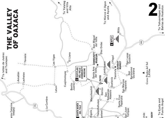
The riches, both cultural and economic, of the city of Oaxaca flow largely from its surrounding hinterland, the Valley of Oaxaca, a mountain-rimmed patchwork expanse of fertile summer-green (and winter-dry) fields, pastures, villages, and reed-lined rivers and streams. By far Oaxaca’s largest valley, both in size and population, with an aggregate population of about half that of the central city, the Valley of Oaxaca consists of three subvalleys—the Valley of Tlacolula, the Valley of Ocotlán, and the Valley of Etla—that each extend, respectively, about 30 miles east, south, and northeast of Oaxaca City.
The Valley of Oaxaca is unique in a number of ways. Most importantly, the inhabitants are nearly all indigenous Zapotec-speaking people. You will often brush shoulders with them, especially in the big markets in Tlacolula, Ocotlán, Zaachila, and Etla. The women traditionally dress in attractive bright skirts and blouses, with their hair done up in colorful ribbon-decorated braids. Although only a fraction of them speak fluent Spanish, they will nearly always understand and appreciate a smile and friendly “buenos dias” or “buenas tardes.”
The Valley of Oaxaca’s vibrant and prosperous native presence flows from a fortunate turn of history. During the mid-1800s, Mexico’s Laws of the Reform forced the sale of nearly all church lands throughout the country. In most parts of Mexico, rich Mexicans and foreigners bought up much of these holdings, but in Oaxaca, isolated in Mexico’s far southern region, there were few rich buyers, so the land was bought at very low prices by the local people, most of them indigenous farmers. Moreover, after the Revolution of 1910–1917, progressive federal-government land-reform policies awarded many millions of acres of land to campesino communities, notably to Oaxaca Valley towns Teotitlán del Valle and Santa Ana del Valle, whose residents now conserve many thousand acres of rich valley fields and foothill forests.
HIGHLIGHTS
 Santa María del Tule: Townsfolk have literally built their town around their gigantic beloved El Tule tree, a cousin of the giant redwood trees of California (
 Santa María del Tule).
 Teotitlán del Valle: Fine wool carpets and hangings, known locally as tapetes, are the prized product of dozens of local family workshop-stores (
 TEOTITLÁN DEL VALLE).
 Mitla: Explore the monumental plazas and columned buildings, handsomely adorned by a treasury of painstakingly placed greca (Grecian-like) stone fretwork (
 MITLA).
 San Bartolo Coyotepec: A small city of roadside home-workshops and a must-see museum display of the pearly-black pottery pioneered by celebrated potter Doña Rosa a generation ago (
 SAN BARTOLO COYOTEPEC).
 Zaachila: Its monumental archaeological zone and riotously colorful tianguis (native market) make Zaachila a Thursday destination of choice in Oaxaca (
 Zaachila).
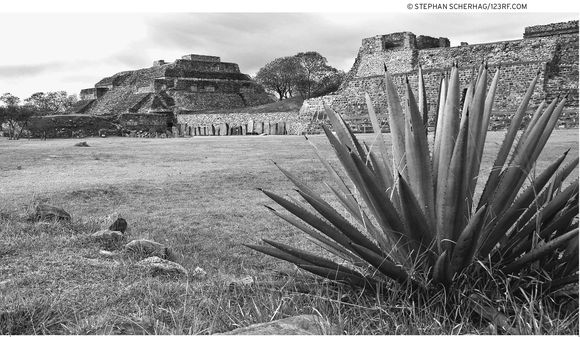
 Monte Albán: Any day is a good day to visit this–Mesoamerica’s earliest true metropolis –which to some still rules from its majestic mountain-top throne (
 MONTE ALBÁN).
 San José El Mogote: Its regal reconstructed pyramids and plazas and the unforgettably red diablo enchilado sculpture displayed in its community museum, plus the neighboring Etla market, make San José El Mogote a worthwhile Wednesday excursion (
 SAN JOSÉ EL MOGOTE).
LOOK FOR  TO FIND RECOMMENDED SIGHTS, ACTIVITIES, DINING, AND LODGING.
Although the grand monuments, fascinating museums, good restaurants, and inviting handicrafts shops of Oaxaca City alone would be sufficient, a visit to Oaxaca is doubly rich because of the manifold wonders of the surrounding Valley of Oaxaca. The must-see highlights of the valley are the timeless Mitla and Monte Albán archaeological sites and the fetching crafts—wool weavings, pearly black pottery, floral-embroidered blouses and dresses, and alebrijes (wood-carved animals). You could easily spend a week or more of your time touring the Valley of Oaxaca from a base in Oaxaca City.
You can even let the valley’s tianguis (literally, “shade awnings” and synonymous with “native markets”) guide you along your excursion path. Along the way, beneath the shadowed market canopies and the shops of Oaxaca’s welcoming local people, you can look, choose, and bargain for the wonderful handicrafts that travelers from all over the world come to the Valley of Oaxaca to buy.
PLANNING YOUR TIME
If your time is limited, your enviable task is to pick, according to your own interests, the best of the best from the Valley of Oaxaca’s treasury of colorful markets, bucolic handicrafts villages, mysterious archaeological sights, and community museums. In a whirlwind four or five days, you can soak in the valley’s celebrated highlights, scheduling your time according to the weekly market days.
Given the limited hotel choices in the Valley of Oaxaca and the relatively short distances (16–48 km/10–30 mi) to valley sights from Oaxaca City, you could use your lodging in the city as a home base and take excursions from there to explore the valley.
For transportation, you could hire a guide for about $150–200 per day, which should include a car for 4–5 people; rent a car for around $50 per day ($250 per week); or use private tourist bus transportation for $10–15 per person. Each of these options can get you to most of the valley’s highlights over three or four days. A fourth option, touring by local public bus from camionera central segunda clase (second-class bus station) is much cheaper, but it requires twice the time.
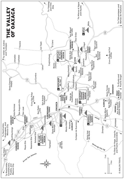
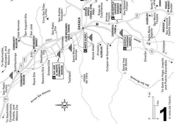
Some sights you won’t want to miss are the archaeological zones of Mitla, on the east side, and Monte Albán, on the southwest side of the valley. Of the markets, the biggest are the Tlacolula Sunday market, the Ocotlán Friday market, the Etla Wednesday market, and the Zaachila Thursday market. Fascinating crafts villages along the way are Teotitlán del Valle (on the way to Tlacolula and Mitla); Santo Tomás Jalieza, San Martín Tilcajete, and San Bartolo Coyotepec (on the way back to Oaxaca City from Ocotlán); and the Santa María Atzompa pottery village (on the way to or from Monte Albán).
If your time is very limited, you could skip the Tlacolula market, but make sure to visit the Thursday market in Zaachila, unbeatable for its intensely colorful ambience and exotic fruits and other food. Be sure to include the nearby Zaachila archaeological site in your visit.
On the other hand, if you have an extra day, it would be worthwhile to visit the San José El Mogote archaeological site and the adjacent community museum. Continue to the Etla market, especially good on Wednesdays.
GETTING AROUND
Taxis, Buses, and Rental Cars
For short runs in downtown Oaxaca, street taxis ($2–3, 25–35 pesos) are quick and secure. Be sure to establish the price before getting into the taxi. If it’s too high, hail another taxi.
For Oaxaca Valley touring, the cheapest (but not quickest) option is to ride a bus from the west-side Abastos market camionera central segunda clase (second-class bus terminal). The buses run everywhere in the Valley of Oaxaca and beyond. Arrive early any day and you could cover most major valley destinations in about a week: two days east (Teotitlán, Tlacolula, Mitla), two days south (crafts villages, Ocotlán market), two days southwest and west (Zaachila market and archaeological site, Cuilapan, Arrazola, Monte Albán, and Atzompa), and one day northwest (Etla market and San José El Mogote).
Get to the second-class bus terminal by walking one block south from the zócalo’s southwest corner, turn right at Las Casas, and keep walking about seven blocks. With caution, cross the periférico. The big terminal is two blocks farther, on the right.
More leisurely options include renting a car or riding a private tourist bus, or both. Get your car rental through either a travel agent or U.S. and Canadian toll-free car rental number before you leave home, or in Oaxaca locally: Hertz (at airport, or Valdivieso 100, tel. 951/139-8845, cell tel.044-951 /508-8721, oax60@avasa.com); Alamo (at airport or Cinco de Mayo 203, tel. 951/511-6220, tel./ fax 951/514-8534, fax 951/514-8686, oaxalamo@hotmail.com); and Europcar (at airport, or at Matamoros 101, tel./fax 951/143-8340, toll-free tel. in Mexico, tel. 800/201-1111 or 800/201-2084).
For economical private transportation-only tourist buses, a good bet is to go with Viajes Turísticos Mitla (at Hóstal Santa Rosa, Trujano 201, tel./fax 951/514-7800 or 951/514-7806, fax 951/514-3152), a block west of the zócalo’s southwest corner. They offer many tours, including a guide and transportation, for small- or medium-size groups. You can also contact their main office (Mina 501, tel./fax 951/514-3152), three blocks west, three blocks south of the zócalo’s southwest corner.
Guided Tours
Many private individual guides offer tours. One of the the most highly recommended is fluent-in-English Juan Montes Lara (Prol. de Eucaliptos 303, Colonia Reforma, tel./fax 951/513-0126, jmonteslara@yahoo.com, $25/ hour), backed up by his wife Karin Schutte. Besides cultural sensitivity and extensive local knowledge, they can also provide comfortable transportation in a Chrysler van.
Moreover, satisfied customers rave about guide Sebastiañn Chino Peña (local cell tel. 044-951/508-1220, tel. 951/562-1761, sebastian_oaxaca@hotmail.com, $20/hour). He offers tours of anywhere you would like to go in the Valley of Oaxaca.
Another promising guide option is Judith Reyes López (B&B Oaxaca Ollin, Quintana Roo 213, tel./fax 951/514-9126, ju-dithreyes37@hotmail.com or reservations@oaxacaollin.com, www.oaxacaollin.com), who operates through her Art and Tradition tours. Judith offers tours ranging from half-day city tours and whole-day Valley of Oaxaca archaeological and crafts-village outings to farther-reaching explorations of the art and architecture of venerable Dominican churches in the Mixteca. Contact her at her bed-and-breakfast, Oaxaca Ollin, a block north and a block east of the Centro Cultural de Santo Domingo.
On the other hand, folks interested in the exceedingly diverse natural world of Oaxaca might appreciate a tour led by biologist Fredy Carrizal Rosales, owner-operator of Tourism Service in Ecosystems (tel. 951/515-3305, in-town cell tel. 044-951/164-1897, ecologiaoax-aca@yahoo.com.mx). Fredy offers customized explorations of many Oaxaca locations—pine-oak woodlands, coastal mangrove wetlands, semi-desert highlands, lush coastal foothill forest coffee plantations—viewing and identifying plants and animals and enjoying nature in general.
Customized explorations of Oaxaca’s indigenous communities, traditions, and natural treasures are the specialty of native Zapotec guide Florencio Moreno, who operates Academic Tours in Oaxaca (Nieve 208A, Colonia Reforma, home tel. 951/518-4728, in-town cell tel. 044-951/510-2244, info@academictoursoaxaca.com, www.academictoursoaxaca.com). Florencio’s tours reflect his broad qualifications: fluency in native dialects, historical knowledge, cultural sensitivity, personal connections with indigenous crafts communities, and expertise in wildlife-watching and identification. His excursions can be designed to last a day or a week and include any region of Oaxaca, exploring anything from folk art and hidden archaeological sites to the colorful indigenous markets and festivals of the Mixteca or the Isthmus.
Higher up the economic scale, commercial guided tours also provide a hassle-free means of exploring the Valley of Oaxaca. Travel agencies, such as Viajes Turisticos Mitla (at Hóstal Santa Rosa, Trujano 201, tel./fax 951/514-7800 or 951/514-7806, fax 951/514-3152), Viajes Xochitlán (M. Bravo 210A, tel. 951/514-3271 or 951/514-3628, www.xochitlan-tours.com.mx, oaxaca@xochitlan-tours.com.mx, 9 A.M.–2 P.M. and 4–7 P.M. Mon.–Sat.), and others, offer such tours.
For even more guide recommendations, check at the Oaxaca state tourist information office (Av. Juárez 703, west side of El Llano park, tel. 951/516-0123, www.aoxaca.com, info@aoaxaca.com, 8 A.M.–8 P.M. daily).
East Side: The Textile Route
The host of colorful enticements along this path could tempt you into many days of delightful exploring. For example, on Saturday you could head out, visiting the great El Tule tree and the weavers’ shops in Teotitlán del Valle and continuing east for an overnight at Mitla. Next morning, explore the Mitla ruins, then return, stopping at the hilltop Yagul archaeological site and the Sunday market at Tlacolula. In either direction, going or coming from the city, you could pause for a brief exploration at the Dainzu and Lambityeco roadside archaeological sites.
One more day would allow time to venture past Mitla to the remarkable mountainside springs and limestone mineral deposits at Hierve El Agua. Stay longer and have it all: a two- or three-day stay in a colorful market town, such as Tlacolula, with a side trip to visit the textile market and community museum at Santa Ana del Valle and also perhaps to a quiet backcountry village, such as San Bartolomé Quialana or San Marcos Tlapazola, south of Tlacolula.
EL TULE AND TLACOCHAHUAYA
 Santa María del Tule
El Tule is a gargantuan Mexican ahuehuete (cypress), probably the most massive tree in Latin America. Its gnarled, house-size trunk divides into a forest of elephantine limbs that rise to bushy branches reaching 15 stories overhead. The small town of Santa María del Tule, 14 kilometers (nine mi) east of Oaxaca City on Highway 190, seems built around the tree. A crafts market, a church, and the town plaza, where residents celebrate their El Tule with a fiesta on October 7, all surround the beloved 2,000-year-old living giant.
Note: Eastbound Highway 190 to El Tule divides inbound traffic, either to the left along a town bypass, beneath a viaduct, or to the right, passing over the viaduct to the town and the El Tule tree.
Tlacochahuaya
At San Jerónimo Tlacochahuaya (tlah-koh-chah-WYE-yah), about seven kilometers (four mi) east of El Tule, stands the village’s pride and joy, the venerable 16th-century Templo y Ex-Convento de San Jerónimo. Dominican padres and their native acolytes, under the guidance of Father Jordán de Santa Catalina, began its construction in 1586 and completed it a few decades later.
Tlacochahuaya is usually a quiet little town except during holidays, notably the eight days of processions, dances, fireworks, and food that climax on September 30, the feast day of San Jerónimo.
The church’s relatively recent 1991 restoration glows so brilliantly, especially from the white baroque facade, that, standing beneath the spreading wild fig tree in the courtyard (or more precisely, atrium), you can feel the facade reflecting the warmth of the late afternoon sun. The atrium appears big enough to assemble a crowd of about 5,000 folks, probably the number of local indígenas the padres hoped to convert during the 16th century. At the atrium’s corners stand the three open-air but arch-roofed chapels, or pozas, where the conversions took place.
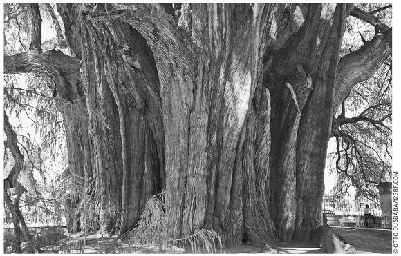
El Tule may be the largest cypress tree in Latin America.
Above the entrance portal, see San Jerónimo standing piously, his left hand on a skull, listening for the voice of God. Inside, glance upward at the lovely nave ceiling and appreciate the still-vital spirit of those long-dead artists who created its flowery, multicolored swirls. Look for the group of oil paintings depicting the legend of the Virgin of Guadalupe, with the last showing the roses miraculously tumbling from Juan Diego’s cape, emblazoned with her image.
Once when I visited, near the entrance was the pledge of the Sacerdote de Cristo (Priest of Christ), which, translated, reads:
The priest of Christ offers
THIS MASS
As if it were your
FIRST MASS
As if it were your
ONLY MASS
As if it were your
LAST MASS
Get there by car, guide, or the Sociedad Cooperativa Valle del Norte or Fletes y Pasajes local bus from the camionera central segunda clase in Oaxaca City.
DAINZU AND LAMBITYECO ARCHAEOLOGICAL SITES
Among the several Valley of Oaxaca buried cities, Dainzu and Lambityeco, both beside Highway 190, are the most accessible. Dainzu comes first, on the right, about nine kilometers (six mi) east of El Tule.
Dainzu
Dainzu (in Zapotec, “Hill of the Organ Cactus”; Hwy. 190, no phone, 10 A.M.–5 P.M. daily, $3) spreads over an approximate half-mile square, consisting of a partly restored ceremonial center surrounded by clusters of unexcavated mounds. Beyond that, on the west side, a stream runs through fields, which at Dainzu’s apex (around A.D. 300) supported a town of about 1,000 inhabitants.
The major excavation, at the foot of the hill about a hundred yards south of the parking lot, reveals more than 30 bas-reliefs of ball players draped with leather head, arm, and torso protectors. Downhill, to the west, lies the partly reconstructed complex of courtyards, platforms, and stairways. The northernmost of these was excavated to reveal a tomb, with a carved door supporting a jaguar head on the lintel and arms—note the claws extending down along the stone doorjambs. The jaguar’s face, with a pair of curious vampire teeth and curly nostrils, appears so bat-like that some investigators have speculated that it may represent a composite jaguar-bat god.
A couple of hundred yards diagonally southwest you’ll find the ball court running east–west in the characteristic I-shaped layout, with a pair of “scoring” niches at each end and flanked by a pair of stone-block grandstandlike seats. Actually, archaeologists know that these were not seats, because the blocks were once stuccoed over, forming a pair of smooth inclined planes (probably used for glancing shots) flanking the central playing area.
Lambityeco
Ten kilometers (six mi) farther, Lambityeco (Hwy. 190, 10 A.M.–5 P.M. daily) is on the right, a few miles past the Teotitlán del Valle side road. The excavated portion, only about 100 yards square, is a small but significant part of Yegui (Small Hill in Zapotec), a large buried town dotted with hundreds of unexcavated mounds covering about half a square mile. Salt-making appears to have been the main occupation of Yegui people during the town’s heyday, around A.D. 700. The name “Lambityeco” may derive from the Arabic-Spanish alambique, the equivalent of the English “alembic,” or distillation or evaporation apparatus. This would explain the intriguing presence of more than 200 local mounds. It’s tempting to speculate that they are the remains of cujetes, raised leaching beds still used in Mexico for concentrating brine, which workers subsequently evaporate into salt.
In the present small restored zone archaeologists have uncovered, besides the remains of the Valley of Oaxaca’s earliest known temazcal (a curative hot room), a number of fascinating ceramic sculptures. Next to the parking lot, a platform, mound 195, rises above ground level. If, after entering through the gate, you climb up its partially restored slope and look down into the excavated hollow in the adjacent east courtyard, you’ll see stucco friezes of a pair of regal, lifelike faces, one male and one female, presumably of the personages who were found buried in the royal grave (Tomb 6) below. Experts believe this to be the case, because the man was depicted with the symbol of his right to rule—a human femur bone, probably taken, as was the custom, from the grave of his chieftain father.
See TOWN NAMES
Mound 190, sheltered beneath the adjacent large corrugated roof about 50 yards to the south, contains a restored platform decorated by a pair of remarkably lifelike, nearly identical divine stucco masks. These are believed to be of Zapotec rain god Cocijo (see the water flowing from the mouths). Notice also the rays, perhaps lightning, representing power, in one hand, and flowers, for fertility, in the other.
 TEOTITLÁN DEL VALLE
Teotitlán del Valle (pop. 5,000), 14 kilometers (nine mi) east of El Tule, at the foot of the northern Sierra, means “Place of the Gods” in Nahuatl; before that, it was known, appropriately, as Xa Quire (shah KEE-ray), or “Foot of the Mountain,” by the Zapotecs who settled it at least 2,000 years ago (by archaeologists’ estimate). From the age of artifacts uncovered beneath both the present town and at nearby sites, experts estimate that approximately 1,000 people were living in Teotitlán by A.D. 400.
Present-day Teotitlán people are relatively well off, not only from sales of their renowned tapetes (wool rugs), but from their rich communal landholdings. Besides a sizable swath of valley-bottom farmland and pasture, which every Teotitlán family is entitled to use, the community owns a dam and reservoir and a small kingdom of approximately 100,000 acres of sylvan mountain forest and meadow, spreading for about 32 kilometers (20 mi) along the Valley of Oaxaca’s lush northeastern foothills.
Getting Oriented
Teotitlán del Valle has two principal streets: Juárez, the entrance road, which runs northerly about four kilometers (2.5 mi) from the highway; and Hidalgo, which intersects Juárez at the center of town. Turn right at Hidalgo (where the pavement becomes cobbled) and you’ll be looking east, toward the town plaza and the 17th-century town church behind it.
Textile Shops
Nearly every Teotitlán house is a mini-factory where people card, spin, and color wool, often using hand-gathered natural dyes. Each step of wool preparation is laborious; obtaining pure water is even a chore—families typically spend two days a week collecting it from mountain springs. The weaving, on traditional handlooms, is the final, satisfying part of the process. The best weaving is generally the densest, typically packing in about 18 strands per centimeter (45 strands per inch); ordinary weaving incorporates about half that. Please don’t bargain too hard. Even the highest prices typically bring the weavers less than a dollar an hour for their labor.
The Teotitlán del Valle church is built on the original Zapotec temple’s foundation.
Visiting the workshop-stores should be first on your itinerary. The home workshops, once confined to the town center, now sprinkle nearly the entire mile-long entrance road. Half a kilometer (about 0.25 mi) from Highway 190, be sure to visit the cooperative shop Mujeres Que Tejan (Women Who Weave; Juárez, old number 86, new number 162, tel. 951/166-6174), on the right side. The shop is managed by welcoming sparkplug Josefina Jiménez and displays the fine for-sale woven products of 28 women weavers.
In the town center, also be sure not to miss the shop of renowned master Isaac (“Bug in the Rug”) Vasquez (turn left at main crossstreet Hidalgo, number 30, tel. 951/524-4122, 10 A.M.–6 P.M. daily).
A number of Teotitlán workshops are especially welcoming. For example, step into the workshop-restaurant-hotel El Descanso (Juárez 51, tel. 951/524-4152, 8 A.M.–7 P.M. Mon.–Sat., 8 A.M.–3 P.M. Sun.), at the town-center corner of Juárez and Hidalgo.
Also well worth a visit is the charming garden shop of friendly Luis Martínez Jiménez (Juárez 48, tel. in Oaxaca city, 951/516-1675), on the main street. (Luis also arranges very reasonably priced tours by car, check with him at petite Oaxaca City shop: Macedonio Alacalá 402, at the Santo Domingo church corner.)
For some good Teotitlán del Valle tips, visit Ron Mader’s super website (www.planeta.com/ecotravel/mexico/oaxaca/teotitlan.html).
Community Museum
Allow enough time to visit the community museum Balaa Xtee Guech Gulal (Hidalgo, tel. 951/524-4463, 10 A.M.–6 P.M. Tues.–Sun., $3), whose name translates from the local Zapotec as “Shadow of the Old Town.” It’s on the north side of Hidalgo, about a block east of Juárez. Step inside and enjoy the excellent exhibits that illustrate local history, industry, and customs. One display shows the wool-weaving tradition (introduced by the Dominican padres, that replaced the indigenous cotton-weaving craft), including sources of some natural dyes—cochinilla (red cochineal), musgo (yellow moss and lichens), anil (dark blue indigo), and quizache bean (black). Another exhibit shows the local practice of a prospective groom’s service to the bride’s parents. A house mock-up shows the prospective bride making tortillas. Be sure to get a copy of the good English-language explanatory pamphlet.
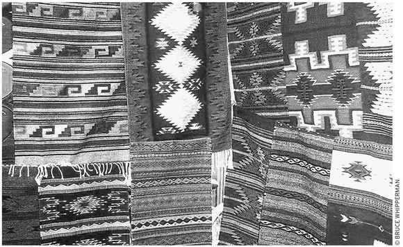
woolen weavings for sale in Teotitlán del Valle
A Walk Around Town
If you ask, a community museum volunteer may be available to lead you on a walking tour of the town and environs. English-speaking Zeferino Mendoza is especially recommended. Walking tour highlights often include visits to weavers’ homes, the church, a traditional temazcal, the recently reconstructed foundation stones of the ancient town, the dam and lake, and the hike to Picacho, the peak above the town’s west side.
Lacking a guide, simply stroll out on your own self-guided tour. After seeing the community museum, head east on Hidalgo. If you haven’t already, take a look around the plaza-front textile stalls, then continue to the Templo de la Precioso Sangre de Cristo (Church of the Precious Blood of Christ). This is the central location for both the patronal festival (July 1–15) and the Fiesta del Señor de La Natividad (Festival of the Lord of the Nativity; first Sun. in Sept.), which include processions, fireworks, and the spectacular Danza de las Plumas (Dance of the Feathers).
The Teotitlán Church
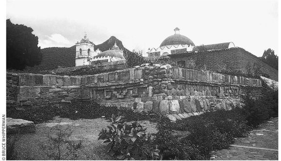
The church itself, built over an earlier Zapotec temple, contains many interesting pre-Columbian stones, which the Dominican friars allowed to be incorporated into its walls. Notice the corn motif carved into the front doorway arch, similar in style to the monolith built into the outside wall at the right of the church entrance steps. Inside, admire the nave’s flowery overhead decorations and the colorful Bible-story paintings. Continue from the nave into the intimate claustro (cloister) and see the Zapotec god of the wind, with stone curls curving upward to represent the wind (on the southwest corner column, to the right as you enter from the nave).
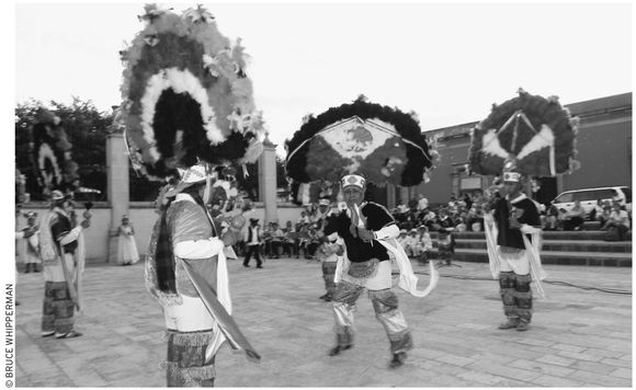
the Dance of the Feathers
Outside, behind the church, continue to the reconstructed foundation corner, on the street, downhill, of the original Zapotec temple. Notice the uniquely Zapotec stone fretwork, similar to the famous Greca remains at Mitla, 32 kilometers (20 mi) farther east.
Farther Afield
If you have time, you can venture even farther afield. One option is to walk or drive along the bumpy, but passable, uphill gravel continuation of main street Juárez about 1.6 kilometers (one mi) to the town dam. After the summer rains, the reservoir fills and forms a scenic lake, good for swimming, picnicking, and even possibly camping, along its pastoral mountain-view shoreline. If you plan to camp at the Teotitlán reservoir, first ask for permission at the community museum (Hidalgo, tel. 951/524-4463, 10 A.M.–6 P.M. Tues.–Sun.) or the presidencia municipal (951/524-4123, www.teotitlandelvalle.gob.mx).
Travelers can extend their Teotitlán adventure all the way into the neighboring mountains. From the Teotitlán reservoir, hike (be prepared with water, good shoes, and a hat), hitchhike, taxi, or drive about 19 more kilometers (12 mi) uphill (with an elevation gain of 1,500 meters/5,000 feet) along the good gravel road to pine-shadowed Benito Juárez and Cuajimoloyas mountain hamlets in northern Oaxaca.
Back at the Teotitlán reservoir, you can also venture up the slope of Picacho, the steep, peaked hill 1.6 kilometers (one mi) west of town. The usual route from town is along Calle 2 de Abril, which heads west, bridging the west-side arroyo. Continue uphill, bearing right at the fork, on to the dirt road at the base of the hill. First you’ll pass some houses, then continue, curving left around the hillside. Eventually, before the summit, you’ll pass some cuevitas (small caves), a holy site where local folks have been gathering for sacred ceremonies each New Year’s Day since before anyone can remember.
Accommodations and Food
Sample Teotitlán’s best at the traditional Tlamanalli restaurant (on Juárez, about a block south of Hidalgo, no phone, 1–4 P.M. daily except possibly Mon. and Thurs., longer hours when more people stop by, $5–10). Their menu of made-to-order Zapotec specialties, such as sopa de calabaza (squash soup) and guisado de pollo (chicken stew) is limited, but highly recommended by Oaxaca City chefs.
If Tlamanalli is closed, go to the inviting Restaurant El Descanso (Juárez 51, tel. 951/524-4152, weaving shop and restaurant 8 A.M.–7 P.M. Mon.–Sat., 8 A.M.–3 P.M. Sun.; lodging $40 d). Your hosts will be the welcoming family of Edmundo and Alicia Montaño, who, besides crafting and selling lovely wool weavings, also serve tasty country fare and offer a number of rooms that open on to their leafy and lovely inner garden-patio. Choices include king-size, regular double, and single beds.
Alternatively, for a lunch or early dinner treat, stop at showplace  Restaurant El Patio (Hwy. 190, 1.2 km/0.8 mile east of the Teotitlán entrance road, tel. 951/514-4889, 10 A.M.–6 P.M. Tues.–Sun.). The restaurant centers around an airy patio, decorated by antique country furniture and a fetching gallery of scenes from the 1940s-era films of the Mexican Golden Age of cinema. The finale is the food: tasty traditional Oaxacan dishes, such as ensalada Oaxaqueña, Zapotec soup, and the house specialty botana Don Pepe.
Getting There
You can go to Teotitlán del Valle by car, tour, taxi, or bus. Drivers: Simply turn left from Highway 190 at the signed Teotitlán del Valle side road, 14 kilometers (nine mi) east of El Tule. By bus: Ride a Fletes y Pasajes Tlacolula- or Mitla-bound bus from the camionera central segunda clase (in Oaxaca City by the Abastos market at the end of Las Casas, past the periférico west of downtown). Alternatively, ride the hourly Valle del Norte bus from the camionera central segunda clase parking lot. Get off at the signed bus stop and walk, taxi, or hitchhike the four kilometers (2.5 mi) into town.
SANTA ANA DEL VALLE
This is a sleepier version of Teotitlán del Valle, where virtually every family speaks the Zapotec tongue at home and earns at least part of its living through weaving. Many older folks understand Spanish only with difficulty. Santa Ana del Valle, like Teotitlán, has thousands of acres of communal lands in the valley bottom and mountains north of the town. Nearly all households tend plots of corn, beans, and vegetables. Most also graze cattle, sheep, and goats in specified communal areas. These lands have been traditionally held by the town since before the conquest. Families may buy or sell shares of their allotted land, but only within the Santa Ana del Valle community.
Community Museum
Your first stop should be at the excellent community museum Shan Dany (tel. 951/562-1705, 11 A.M.–3 P.M. and 4–7 P.M. Mon.–Sat.), on the town plaza opposite the presidencia municipal. The exhibits include an archaeological section with pre-conquest remains found during a recent plaza-front construction project. Also notice the ponderous monolith, brought from the mountain above town, carved with the visage of Cocijo, the god of lightning and rain. Another museum section details 1910–1917 revolutionary history, when townsfolk had to flee to the hills and wage a guerrilla war against rampaging forces of “Primer Jefe” General Venustiano Carranza.
Toward the rear of the museum, a pair of excellent displays illustrate more community lore: one shows many of the naturally occurring dyes, including avocado seeds, guaje bark, and copal bark, that local weavers gather and use; the other explains the Danza de la Pluma (Dance of the Feathers), in which a dozen young men dance and brighten the town plaza with their huge, round feathered hats. This dance takes place during the July 26 and August 14–16 split-date festival in honor of Santa Ana.
A Walk Around Town
Ask and a museum volunteer may be able to find a guide (offer to pay) to lead you on a two- or three-hour recorrido (tour) around town, including the presa (dam and small reservoir); a creek, where you can cool off during the summer rainy season (bring your bathing suit); a breezy mirador (viewpoint) for a spectacular valley vista; and an old gold, silver, and copper mine. During the walk, your guide might identify and explain the uses of the many medicinal plants along the path. Be sure to ask them to point out the poison oak–like mala mujer (bad woman) bush to you. Finally, ask them to take you to shops of outstanding local weavers for demonstrations and possible purchases of their work.
If you can’t get a guide, you can still do most of the walk on your own. The path to the dam takes off from Calle Plan de Ayala, on the east, uphill side of town. After about 0.8 kilometers (0.5 mi), bear left, around the hill. If you get confused, ask a younger person (they’re most likely to understand Spanish), “¿Donde está la presa” (PRAY-sah), “por favor?” The viewpoint, the big moss-mottled rock about halfway up the steep, left-hand slope, sticks out of the hillside above the path to the dam.
Accommodations
The comfortable Santa Ana del Valle tourist  cabaña ecoturística is at Calle Moreles #2, on the entrance road to town. It is well situated for exploring, being just a few blocks from the center of town. The nightly rate is approximately $30 for one to four people, with toilet, hot-water shower-bath, and two double or bunk beds. Reserve at the community museum (on the town plaza, tel. 951/562-1705, 11 A.M.–3 P.M. and 4–7 P.M. Mon.–Sat.), either in person or by telephone.
Shopping
Although Santa Ana del Valle weavers sell much of their work through shops in Teotitlán del Valle and Oaxaca City, they also sell directly in town, from both the Mercado de Artesanías on the town plaza and their home workshops. For suggestions of who to visit, ask at the community museum (on the town plaza, tel. 951/562-1705), or go directly to Casa Martínez (Matamoros 3, corner of V. Carranza, tel. 951/562-0366), the house of personable master weaver Ernesto Martínez. His house is around the corner, a few doors downhill from the town plaza. You’ll also be welcome at the home shop of the friendly weaving family of Alberto Sánchez Garcia (Sor Juanes Inés de la Cruz 1, no phone), a few blocks from the town plaza.
For some good Santa Ana del Valle tips, visit Ron Mader’s super website (www.planeta.com/ecotravel/mexico/oaxaca/santana.html).
Getting There
You can go to Santa Ana del Valle by car, tour, taxi, or bus. Drivers: Turn left at the fork across Highway 190 from the Tlacolula Pemex gasolinera 38 kilometers (24 mi) east of Oaxaca City. After 0.8 kilometers (0.5 mi), turn left again at the signed Santa Ana del Valle side road. Continue another few minutes; pass the tourist cabaña ecoturística on the right, and arrive at the town plaza a few blocks farther. By bus, you can ride a Tlacolula- or Mitla-bound bus from the camionera central segunda clase in Oaxaca City by the Abastos market (end of Las Casas, west of downtown). Get off at the Tlacolula stop on Highway 190 by the Pemex station. Cross to the side road on the north side of the highway and take a taxi, ride the Transportes Municipal del Santa Ana del Valle local bus, or hike the 6.4 kilometers (four mi) from the highway—walk the side road 0.8 kilometers (0.5 mi) to a signed Santa Ana del Valle fork; go left and continue for 3.2 more kilometers (two mi), passing the cabaña ecoturística, at Calle Moreles #2, on the right, and then on to the town plaza a few blocks farther.
TLACOLULA
The Zapotec people who founded Tlacolula (pop. 15,000, 38 km/24 mi east from Oaxaca City) around A.D. 1250 called it Guichiibaa (“Place Between Heaven and Earth”). Besides its beloved church and chapel and famous Sunday market, Tlacolula is also renowned for mescal, a Tequila-like alcoholic beverage distilled from the fermented hearts of maguey. Get a good free sample at the friendly Pensamiento shop (Juárez 9, tel. 951/562-0017, 9 A.M.–7 P.M. daily), about four blocks from the highway gasoline station (along Juárez) toward the market. Besides many hand-embroidered Amusgo huipiles and Teotitlán weavings, proprietor Guadalupe Pensamiento offers fruit and spice-flavored mescal, which, at this writing, came in 40 flavors, 16 for men and 24 for women.
Just before the market, take a look inside the main town church, the 1531 Parroquia de la Virgen de la Asunción. Although its interior is distinguished enough, the real gem is its attached chapel, Capilla del Señor de Tlacolula, which you enter from the nave of the church. Every inch of the chapel’s interior gleams with sculptures of angels and saints, paintings, and gold scrollwork. Notice the pair of floating angels, each holding a great pendulous solid silver censer, on opposite sides of the altar; also, admire the solid silver fence in front of the altar. Saints seem to live on in every corner of the chapel. Especially graphic are the martyrs, who reveal the way they died, such as a sorrowful San Sebastián, his body shot full of arrows, and a decapitated San Pablo, above the right transept, his head on the ground.
Ordinarily tranquil, the church grounds seem to nearly burst with the faithful during the five-day Fiesta del Santa Cristo de Tlacolula, climaxing on the second Sunday of October, when the plaza is awash with merrymakers. It is then that folks enjoy their favorites, the Danza de los Jardineros (Dance of the Gardeners) and the spectacular Danza de las Plumas (Dance of the Feathers), along with a pelota mixteca (traditional Mixtec ball game) tournament.
The big gate bordering the church grounds leads you to the Tlacolula market. One of Oaxaca’s biggest and oldest, the Tlacolula market draws tens of thousands from all over the Valley of Oaxaca every Sunday. Wander around and soak it all in—the diverse crowd of buyers and sellers, and the equally manifold galaxy of merchandise. How about a hand-hewn yoke for your oxen, or a new stone mano (roller) and metate (flat stone) for your kitchen? If not, perhaps some live (or ground) chapulines (grasshoppers), maybe a live turkey for dinner tomorrow, or a hunk of sugarcane to chew on while you stroll?
For food and accommodations, try the basic but clean downtown Tlacolula lodging, the Hotel and Restaurant Calenda (Juárez 40, tel. 951/562-0660, food $3–8, lodging $20 s or d, $30 t). They offer about 30 rooms with fans and hot-water shower-baths in three floors around an interior restaurant courtyard. Their restaurant serves a wholesome country menu that, although specializing in barbacoa pollo, chivo, or borrego (barbecue chicken, goat, or lamb), offers many more hearty choices, such as pork chops, spaghetti, eggs, fish, and chiles rellenos.
YAGUL ARCHAEOLOGICAL ZONE
The regal remains of Yagul (Zapotec for “Old Tree”; 45 km/28 mi east of Oaxaca City, just north of Hwy. 190, 10 A.M.–5 P.M. daily, $3) preside atop their volcanic hilltop. Although only 12 kilometers (7.5 mi) from Mitla and sharing architectural details, such as Mitla’s famous Greca fretwork, the size and complexity of its buildings suggest that Yagul was an independent city-state in its own right. Local folks call the present ruin the Pueblo Viejo (Old Town) and remember it as the forerunner of the present town of Tlacolula. Archaeological evidence, which indicates that Yagul was occupied for about a thousand years, at least until around A.D. 1100 or 1200, bears them out.
One of Yagul’s major claims to fame is its Palace of Six Patios, actually three nearly identical but separate complexes of two patios each. In each patio, rooms surround a central courtyard. The northerly patio of each complex is more private and probably was the residence, while the other, more open patio served administrative functions.
South of the palace sprawls Yagul’s huge ball court, the second largest in Mesoamerica, shaped in the characteristic Oaxaca I configuration. Southeast of the ball court is Patio 4, consisting of four mounds surrounding a courtyard. A boulder sculpted in the form of a frog lies at the base of the east mound. At the courtyard’s center, a tomb was excavated; descend and explore its three greca-style, fretwork-decorated chambers.
If it’s not too hot, gather your energy and climb to the hilltop above the parking lot for a fine view of the ruin and the entire Valley of Oaxaca. The name for this prominence—the Citadel—was probably accurately descriptive, for Yagul’s defenders long ago added rock walls to enhance the hilltop’s security.
 MITLA
MITLA
The ruins at Mitla (Hwy. 176, about 57 km/35 mi east of Oaxaca City, 8 A.M.–5 P.M. daily, $5) are a “must” for Valley of Oaxaca sightseers. Mitla (Liobaa in Zapotec, the “Place of the Dead”) flowered late, reaching a population of perhaps 10,000 during its apex around A.D. 1350. It remained occupied and in use for generations after the conquest.
During Mitla’s heyday, several feudalistic, fortified city-states vied for power in the Valley of Oaxaca. Concurrently, Mixtec-speaking people arrived from the north, perhaps under pressure from Aztecs and others in central Mexico. Evidence suggests that these Mixtec groups, in interacting with the resident Zapotecs, created the unique architectural styles of late cities such as Yagul and Mitla. Archaeologists believe, for example, that the striking Greca (Grecian-style) frets that honeycomb Mitla facades are the result of Mixtec influence.
Exploring the Site
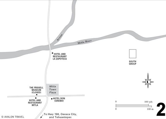
In a real sense, Mitla lives on. The ruins coincide with the present town of San Pablo Villa de Mitla, whose main church actually occupies the northernmost of five main groups of monumental ruins. Virtually anywhere archaeologists dig within the town they hit remains of the myriad ancient dwellings, plazas, and tombs that connected the still-visible landmarks.
Get there by forking left from main Oaxaca Highway 190 onto Highway 176. Continue about two miles to the Mitla town entrance, on the left. Head straight through town, cross a bridge, and, after about a mile, arrive at the site. Of the five ruins clusters, the best preserved is the fenced-in Columns Group. Its exploration requires about an hour. Three of the others—the Arroyo and Adobe Groups beyond an arroyo, and the South Group across the Mitla River—are rubbly, unreconstructed mounds. Evidence indicates the Adobe and South Groups were ceremonial compounds, while the Arroyo, Church, and Columns Groups were palaces.
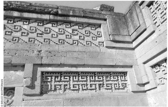
Hundreds of thousands of pieces of Greca stone fretwork make up Mitla’s magnificent buildings.
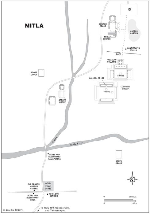
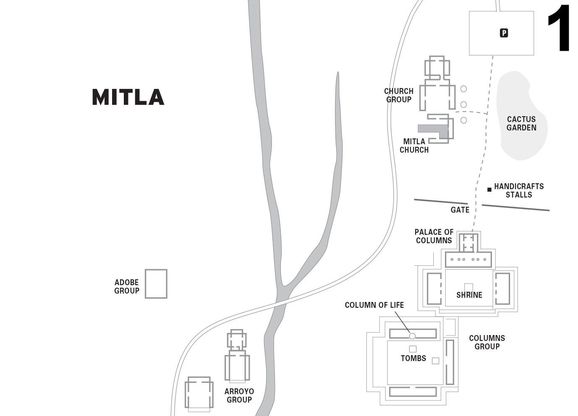
The interesting Church Group (marked by the monumental columns that you pass first on your right after the parking lot) is on the far north side of the Palace of Columns. Builders used the original temple stones to erect the church here. Although the Church Group has suffered from past use by the local parish, it deserves a few minutes’ look around inside. It consists of a pair of regal courtyards, labeled A and B, adjacent to the triple red-domed 16th century church. You first enter courtyard B, enclosed by monumental stone-framed doorways. A passageway leads to smaller courtyard A, where you can see the fascinating remnants of the red hieroglyphic paintings of personages, name-dates, and glyphs that once covered its walls.
Back outside, on the main entrance path, continue past the tourist market and through the gate to the Columns Group. Inside, two large patios, joined at one corner, are each surrounded on three sides by elaborate apartments. A shrine occupies the center of the first patio. Just north of this stands the Palace of Columns, the most important of Mitla’s buildings. It sits atop a staircase, inaccurately reconstructed in 1901.
Inside, a file of six massive monolithic columns supported the roof. A narrow “escape” passage exits out the right rear side to a large patio enclosed by a continuous narrow room. The purely decorative Greca facades, which required around 100,000 cut stones for the Columns Group complex, decorate the walls. Remnants of the original red and white stucco that lustrously embellished the entire complex hide in niches and corners.
Walk south to the second patio, which has a similar layout. Here the main palace occupies the east side, where a passage descends to a tomb beneath the front staircase. Both this and another tomb, beneath the building at the north side of the patio, are intact, preserving their original crucifix shapes. (The guard, although he is not supposed to, may try to collect a tip for letting you descend.) No one knows for certain who and what were buried in these tombs, which were open and empty at the time of the conquest.
See THE MYSTERY OF MITLA’S FRISSELL MUSEUM
The second tomb is similar, except that it contains a stone pillar called the Column of Life; by embracing it, legend says, you will learn how many years you have left.
Fiesta del Apóstol de San Pablo
Mitla (pop. 15,000), although famous, is a quiet town where tranquility is disturbed only by occasional tourist buses along its dusty, sun-drenched main street. A major exception occurs during Mitla’s key fiesta, which centers on the town’s venerable 16th-century church, dedicated to San Pablo Apóstol (St. Paul the Apostle). If you plan your visit during the eight days climaxing around January 25 (or also around June 29, the day of St. Pablo and St. Pedro), you can join with the townsfolk as they celebrate their patrón with masses, processions, a feast, fireworks, jaripeo (bull roping and riding), and dancing.
Accommodations and Food
Stop for a refreshment at the homey Hotel and Restaurant Mitla (Benito Juárez 6, tel. 951/568-0112, cell tel. 044-951/115-5676, food 8 A.M.–7 P.M. daily; lodging $15 s, $22 d), domain of the sparkplug mother-daughter team of Teresa and Gloria González de Quero. Here you can enjoy Mexico as old-timers remember it, in a charmingly ramshackle hacienda-style farmhouse, where roosters crow, dogs snooze, and guests can have their seasonal fill of bananas, avocados, mandarins, and zapotes from a shady backyard huerta (orchard). Their 16 rooms vary. Most rooms in the upstairs tier—plain but clean (if you don’t look too hard), with the essentials, including hot water—are acceptably rustic.
Diagonally across the plaza from the museum is the shiny, four-star neo-colonial-style Don Cenobio Banquet Salon and Hotel (Benito Juárez 3, tel. 951/568-0330, fax 951/568-0050, informes@hoteldoncenobio.com, www.hoteldoncenobio.com, $70 d), with about 20 beautifully decorated rooms built around a large, inviting pool and grassy patio. Guests enjoy a wealth of facilities, including a restaurant and banquet hall for 500 people. Rooms come with air-conditioning, cable TV, queen and king-size beds, and much more. The only drawback to all of this is that they rent the place out to hundreds for conferences and parties quite often. Best to check by telephone before reserving an overnight.
Alternatively, about five blocks north, closer to the archaeological zone, try the family-run  Hotel and Restaurant La Zapoteca (5 de Febrero 12, tel. 951/568-0026, ivettsita_revelde@hotmail.com, food 8 A.M.–6 P.M. daily; lodging $15 s, $20 d, $27 t), on the right just before the Río Mitla bridge. The spic-and-span restaurant, praised by locals for “the best mole negro and chiles rellenos in Oaxaca,” is fine for meals, and the 20 clean, reasonably priced rooms, with hot water, in-house Internet, and parking, are good for an overnight.
Shopping
Instead of making handicrafts, Mitla people concentrate on selling them, mostly at the big handicrafts market adjacent to the archaeological zone parking lot. Here you can sample from a concentrated all-Oaxaca assortment, especially textiles: cotton huipiles, wool hangings and rugs, onyx animals and chess sets, fanciful alebrijes (wooden animals), and leather huaraches, purses, belts, and wallets.
Getting There
Bus travelers can get to Mitla from Oaxaca City by Fletes y Pasajes or Oaxaca-Istmo bus from the camionera central segunda clase. Drivers get there by forking left from main Oaxaca Highway 190, at the big Mitla sign, onto Highway 176. Continue about 3.2 kilometers (two mi) to the Mitla town entrance, on the left. Turn left, and head straight past the town plaza. Continue across the bridge over the (usually dry) Río Mitla, and after about 1.6 kilometers (one mi), arrive at the archaeological site.
HIERVE EL AGUA MINERAL SPRINGS
Although the name of this place translates as boiling water, the springs that seep from the side of the limestone mountain less than an hour’s drive east of Mitla aren’t hot. Instead, they are loaded with minerals. These minerals over time have built up into rock-hard deposits, forming great algae-painted slabs in level spots and, on steep slopes, accumulating into what appear to be grand frozen waterfalls. Note: A local community dispute has unfortunately led to periodic closures of the Hierve El Agua park. Before planning a visit, check at the Oaxaca state tourist information office (Av. Juárez 703, west side of El Llano park, tel. 951/516-0123, 8 A.M.–8 P.M. daily, info@aoaxaca.com, www.aoxaca.com, 8 A.M.–8 P.M. daily). You can also consult with a tour agency or guide, such as the excellent Juan Montes Lara (tel/fax 951/513-0126, cell 951/170-3239).
The Springs
Although Hierve El Agua (9 A.M.–6 P.M. daily, $2) may be crowded on weekends and holidays, you’ll probably have the place nearly to yourself on weekdays. The first thing you’ll see after passing the entrance gate is a lineup of snack and curio stalls at the cliff-side parking lot. A trail leads downhill to the main spring, which bubbles from the mountainside and trickles into a huge basin that the operators have dammed as a swimming pool. Bring your bathing suit.
Part of Hierve El Agua’s appeal is the panoramic view of mountain and valley. On a clear day, you can see the tremendous massif of Zempoatepetl (saym-poh-ah-TAY-pehtl), the grand holy mountain range of the Mixe people, rising above the eastern horizon.
From the ridge-top park, agile walkers can hike farther down the hill, following deposits curiously accumulated in the shape of miniature limestone dikes that trace the mineral water’s downhill path. Soon you’ll glimpse a towering limestone formation, like a giant petrified waterfall, appearing to ooze from the cliff downhill straight ahead, on the right.
Back uphill by the parking lot, operators have augmented the natural springs with a resort-style swimming pool, where, along with everyone else, you can frolic to your heart’s content.
Hikers can also enjoy following a sendero peatonal (footpath) that encircles the entire zone. Start your walk from the trailhead beyond the bungalows past the pool, or at the other end, at the cliff edge between the parking lot and the entrance gate. Your reward will be an approximately one-hour, self-guided tour, looping downhill past the springs and the great frozen rock cascades and featuring grand vistas of the gorgeous mountain and canyon scenery along the way.
The Hierve El Agua zone and surrounding country is habitat for a hardy dry-country palm you’ll probably see plenty of while strolling around. Lack of winter–spring moisture usually keeps the palms small, sometimes clustering in great wild gardens, appearing like regiments of desert dwarfs. Local people gather and weave their fronds into tenates (baskets), petates (mats), escobas (brooms), and more, which they sometimes sell in the stalls by the parking lot.
Accommodations and Food
The Hierve El Agua tourist  cabañas ecoturísticas have in the past provided the key for a restful one- or two-night stay. The several clean and well-maintained housekeeping bungalows, with shower-baths and hot water, rent for about $10 per person, or around $40 for up to six in a bungalow, with refrigerator, stove, and utensils. For information about cabaña reservations, contact the Oaxaca state tourist information office (Av. Juárez 703, west side of El Llano park, tel. 951/516-0123, 8 A.M.–8 P.M. daily, info@aoaxaca.com, www.aoxaca.com, 8 A.M.–8 P.M. daily).
For food, you can bring and cook your own in your bungalow or rely upon the strictly local-style beans, carne asada (roast meat), tacos, tamales, and tortillas offered by the parking-lot food stalls. In any case, fruit and vegetable lovers should bring their own from Oaxaca City. Produce selection in local San Lorenzo village stores will most likely be minimal.
Getting There
Get there by riding an Ayutla-bound Fletes y Pasajes bus east out of either Oaxaca City (departing from camionera central segunda clase) or from Mitla on Highway 179 just east of town. Get off at the Hierve El Agua side road, about 18 kilometers (11 mi) past Mitla. Continue the additional eight kilometers (five mi) by taxi or the local bus marked San Lorenzo. At this writing, the road is open for cars and buses only to the edge of San Lorenzo village, from which you can walk or continue by taxi the additional mile to the Hierve El Agua entrance.
South Side: The Crafts Route
Travelers who venture into the Valley of Oaxaca’s long, south-pointing fingers, sometimes known as the Valleys of Zimatlán and Ocotlán, can discover a wealth of crafts, history, and architectural and scenic wonders. These are all accessible as day trips from Oaxaca City by car or combinations of bus and taxi. Most reachable are the renowned crafts villages of San Bartolo Coyotopec, San Martín Tilcajete, Santo Tomás Jalieza, and others along Highway 175, between the city and the colorful market town of Ocotlán (best to plan a visit to all on Friday, Ocotlán’s market day; start at Ocotlán early and work your way north back to Oaxaca City). Another day, you can either continue farther south, off the tourist track, to soak in the feast of sights at the big market in Ejutla, or fork southwest, via Highway 131 through Zimatlán, to the idyllic groves, crystal springs, and limestone caves hidden around San Sebastián de las Grutas.
 SAN BARTOLO COYOTEPEC
San Bartolo Coyotepec (Hill of the Coyote), on Highway 175, 23 kilometers (14 mi) south of Oaxaca City, is famous for its pottery and its August 23–28 festival, Fiesta de San Bartolomé. During the fiesta, masked villagers costumed as half-man half-woman figures in tiaras, blond wigs, tin crowns, and velvet cloaks dance in honor of their patron.
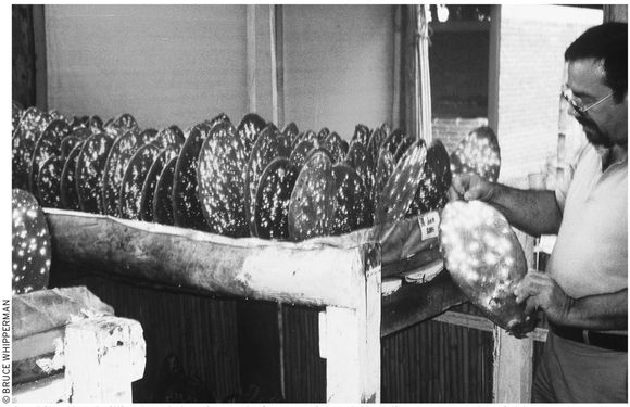
The town’s black pottery, the renowned barro negro sold all over Mexico, is available at the signed Mercado de los Artesanias market on the right and at a number of cottage factory shops (watch for signs) off the highway, scattered along the left (east side) of Calle Juárez, marked by a big Doña Rosa sign. Doña Rosa, who passed away in 1980, pioneered the technique of crafting lovely, big, round jars without a potter’s wheel. With their local clay, Doña Rosa’s descendants and neighbor families regularly turn out acres of glistening black plates, pots, bowls, trees of life, and fetching animals for very reasonable prices (figure on about $20 for a pearly black three-gallon vase, and perhaps $2 for a cute little rabbit).
San Bartolo Museum
Across the highway from the town church, on the town plaza’s southern flank, stands the large, new Museo Estatal de Arte Popular (Plaza Principal, tel. 951/551-0036, 10 A.M.–6 P.M. Tues.–Sun., $4). Although the main event is a fine exposition of San Bartolo Coyotepec’s famed black pottery, the museum also exhibits a surprisingly innovative range of some of the best crafts that the Valley of Oaxaca offers. Besides Doña Rosa’s classic pearly-black examples, a host of other pieces—divine angels, scowling bandidos, fierce devils—reveal the remarkable talent of Doña Rosa’s generation of students and followers.
Cochineal Farm
On your way either to or from San Bartolo Coyotepec and Ocotlán, you’re in for an unusual treat if you stop at the small demonstration cochineal farm and museum Rancho la Nopalera (Km 10.5 Carretera Oaxaca–Puerto Ángel, Calle Matamoros 100, tel. 951/551-0030, fax 951/551-0053, info@aztecacolor.com, www.aztecacolor.com, 9 A.M.–1 P.M. and 2–5 P.M., $3), a few blocks off the highway at San Bartolo Coyotepec.
The farm, officially called the Centro de Difusión del Conocimiento de la Grana Cochinilla y Colorantes Naturales, is the labor of love of retired chemical engineer Ignacio J. del Río Dueñas and his son-in-law, engineer Manuel Loera Fernández. They graciously welcome all visitors—schoolchildren, visiting scholars, neighbors, tourists—to their ranch for the purpose of breathing life into the ancient Oaxaca tradition of cochineal dye, the source of the bright reds in many of the Oaxaca weavings.
Many others besides Señores Dueñas and Fernández believe in cochineal and support its use as a natural dye. Its color, so intensely scarlet that it is sometimes known as the “blood of the nopal,” is produced from the bodies of the scale insect, Dactylopius coccus, that thrives on the thick leaves of the nopal (prickly pear) cactus, found all over Mexico and much of the western United States. Precisely because cochineal is a natural, non-synthetic product, it’s gaining favor as a food and cosmetic (lipstick) coloring. The modest cochineal crop that the farm produces requires the processing of about 600 nopal leaves for each kilogram of cochineal, which sells for about $200.
They (or an assistant) will be happy to show you around their cactus cultivation house and demonstrate how the insects are harvested, and explain their several interesting museum exhibits, which illustrate the history and uses of cochineal.
Get there by bus from the camionera central segunda clase in Oaxaca City, via regional buses Estrella del Valle, Oaxaca Pacifico, or Estrella Roja del Sureste, or more local Choferes del Sur or Halcón buses, which will let you off at the highway, where you can taxi or walk according to the following driver’s directions: By car, from Highway 175, about 7.5 kilometers (4.7 mi) south of the Oaxaca airport, turn right, southbound, at the small blue roadside sign (“El Museo Centro Reproducióa Grana Cochininilla”) at Calle Unión, at the northern, Oaxaca edge of San Bartolo Coyotepec village; after a few hundred yards westbound, on a dirt road, another sign directs you left to the rancho.
Cochineal, a brilliant red dye, is made from an insect that lives on nopal (prickly pear) cactus.
CRAFTS VILLAGES ON THE ROAD TO OCOTLÁN
Each of the three crafts villages not far north of Ocotlán has something unique to offer. In order to visit all of them, plus San Bartolo Coyotopec and Ocotlán, on Friday, you’ll need to get an early start. If you’re inclined to linger, it’s best to allow two days for your visit, with an overnight in Ocotlán. Under any circumstances, visit San Antonino Castillo Velasco on the same Friday that you visit Ocotlán, because it also has its tianguis (native market) on Friday. Two things to look for are the wonderful breads (in the morning, sold out by afternoon), fresh and yummy as you come into town, and the famous vestidos de San Antonino, sometimes known as “Oaxaca wedding dresses,” marked by their elaborately fancy and colorful animal and floral embroidery.
First stop for the vestidos de San Antonino should be the small Artesanías de Castillo Velasco (on the San Antonino entrance road, Av. Castillo Velalsco, on the right, two blocks from the highway, tel. 951/571-0623). Your hosts will be friendly Enrique Lucas G. and his wife Maria Luisa Amador H., who manufacture and offer lovely embroidered vestidos, blusas, and servilletas (dresses, blouses, and napkins), and much more. Their finest vestidos, elaborately adorned with fetchingly colorful floral and animal designs, sell for $100 and up. Besides the goods they display up front, they can show you much more, including men’s wedding shirts, from their rear storeroom.
For more embroidery options, a few women sell dresses and blouses in the regular market on Friday (turn left at the first block after the bread stalls). If you arrive and no one seems to be selling any dresses, mention vestidos de San Antonino, and someone will lead you to a woman who makes them. Alternatively, ask for friendly Rosa Canseco Godines (go-DEE-nays; Calle Guerrero 33, no phone), one of the local mae-stras of the craft. If she’s home, she’ll gladly show you examples of her beautiful work.
Bus passengers, take a taxi or walk 1.6 kilometers (one mi) from Ocotlán. Drivers, turn west at the San Antonino Castillo Velasco sign just at the northern (Oaxaca) edge of Ocotlán.
San Martín Tilcajete and Santo Tomás Jalieza
San Martín Tilcajete (teel-kah-HAY-tay; Hwy. 175, not far north of the Hwy. 131 fork), about 37 kilometers (21 mi) south of Oaxaca City, is a prime source of alebrijes, fanciful wooden creatures occupying the shelves of crafts stores the world over. Both it and Santo Tomás Jalieza (Hwy. 175, south of the Hwy. 131 fork), a mile or two farther south, can be visited as a pair on any day.
The label alebrije, a word of Arabic origin, implies something of indefinite form, and that certainly characterizes the fanciful animal figurines that a generation of Oaxaca woodcarvers has been crafting from soft copal wood. Dozens of factory-stores sprinkle San Martín Tilcajete. Start on the front main street, but also be sure to wander the back lanes and step into several cottage workshops, whose occupants will be happy to show you what they have and demonstrate how they make them. You’ll find lots more than funny animals. Artisans branched out to plants such as purple palm trees and yellow cacti. Some items, such as imaginatively painted jewel boxes and picture frames, are practical, while others, such as miniature sets of tables and chairs, are for kids 3–90. Find some of the most original examples at the back-street shop of Delfino Gutiérrez (Calle Reforma, tel. 951/524-9074), who specializes in free-form elephants, frogs, turtles, armadillos, and much more.
Santo Tomás Jalieza, on the other hand, is known as the town of embroidered cinturones (belts). Women townsfolk, virtually all of whom practice the craft, concentrate all of their selling in a single many-stalled market (Centro de Artesanias, Plaza Principal, no phone,9 A.M.–5 P.M. daily) in the middle of town. Step inside and you’ll be tempted not only by hundreds of hand-embroidered leather belts, but also by a wealth of lovely handloomed and embroidered purses, shawls, dresses, blouses, small backpacks, and much more. Furthermore, asking prices are very reasonable.
A couple of local restaurants received favorable reviews. Although it caters to the tourist crowd, the food is good and innovative at Restaurant Azucena (on the Tilcajete entrance road). On the other hand, for truly rustic, ranch-style ambience, complete with old wagon wheels, wooden picnic-style tables and plenty of savory barbeque, stop by Restaurant Huamuches (on the highway, by the Santo Tomás Jalieza entrance road).
OCOTLÁN
Your first stop in district capital Ocotlán (pop. 20,000, 42 km/26 mi south of Oaxaca) should probably be the interesting trio of family workshops (9 A.M.–6 P.M. daily) run by the Aguilar sisters, Irene, Guillermina, and Josefina. Watch for signs reading “Aguilar,” on the right, on the outskirts, about 0.4 kilometers (0.25 mi) on the Oaxaca side from the town plaza. Their creations include a host of charming figures in clay: vendors with big ripe strawberries, green and red cactus, goats in skirts, and bikini-clad blondes.
The main Ocotlán attraction (unless you’re lucky enough to arrive for the big fiesta on the third Sunday of May) is the huge Friday market. Beneath a riot of colored awnings, hordes of merchandise—much modern stuff, but also plenty of old-fashioned goodies—load a host of tables and street-laid mats. How about a saddle for your donkey? If not that, why not four or five turkeys, a goat, or perhaps half a dozen bags of hard-to-get wild medicinal plants? And be sure to pick up a kilo or two of cal (lime or quicklime) for soaking your corn. If you’re looking for lots of native costumes, you’ll have to head for the mountains, because few women (except for their ribbon-decorated braids) and virtually no men wear traje (traditional indigenous dress). You’ll hear plenty of Zapotec, however. At least half of the local people are native speakers.
Since markets are best in the morning, you should make Ocotlán your first Friday stop. Drivers could get there by heading straight south out of the city, arriving in Ocotlán by mid-morning. Spend a few hours, then begin your return in the early afternoon, stopping at the sprinkling of crafts villages along the road back to Oaxaca. Gasoline is available at the Pemex gasolinera, on the highway, on the north edge of Ocotlán.
Bus travelers could hold to a similar schedule by riding an early Autobuses Estrella del Valle, Autotransportes Oaxaca–Pacífico, or Choferes del Sur from the camionera central segunda clase, then returning, in steps, by bus, or more quickly by taxi, stopping at the crafts villages along the way.
Casa de Cultura Rudolfo Morales
During the 1980s and 1990s, Ocotlán came upon good times, largely due to the late Rudolfo Morales, the internationally celebrated but locally born artist who dedicated his fortune to improving his hometown. The Rudolfo Morales Foundation has been restoring churches and other public buildings, reforesting mountainsides, and funding self-help and educational projects all over Ocotlán and its surrounding district. The bright colors of the plaza-front presidencia municipal and the big church nearby result from the good works of Rudolfo Morales.
The Morales Foundation’s local efforts radiate from the Casa de Cultura Rudolfo Morales (Morelos 108, tel. 951/571-0198, 9 A.M.–2 P.M. and 5–8 P.M. Mon.–Fri., 9 A.M.–3 P.M. Sat.), in the yellow-painted mansion three doors north from the Ocotlán plaza’s northwest corner. In the Casa de Cultura’s graceful, patrician interior, the Morales family and staff manage the foundation’s affairs, teach art and computer classes, and sponsor community events.
The foundation staff welcomes visitors. For advance information, contact the foundation’s headquarters in Oaxaca City (Murguia 105, between Macedonio Alcalá and 5 de Mayo, tel. 951/514-2324 or 951/514-0910, galeria@artedeoaxaca.com, www.artedeoaxaca.com, 11 A.M.–3 P.M. and 5–8 P.M. Mon.–Sat.).
Templo de Santo Domingo
Local people celebrate Rudolfo Morales’s brilliant restoration of their beloved 16th-century Templo de Santo Domingo. Gold and silver from the infamous Santa Catarina Minas (mines), in the mountains east of Ocotlán, financed the church’s initial construction. When overwork and disease tragically decimated the local native population by around 1600, the mines were abandoned, and work on the church stopped. Although eventually completed over the succeeding three centuries, it had slipped into serious disrepair by the 1980s.
Fortunately, the Templo de Santo Domingo is now completely rebuilt, from its bright blue, yellow, and white facade to the baroque gold glitter of its nave ceiling. Inside on the right side, you’ll pass a pious Saint John the Baptist, with Mary Magdalene at his feet. Up front, above the main altar, a white-haired, bearded Creator reigns, resembling an indigenous Father Sun, with a halo of golden rays bursting from behind his head. Below him, Jesus hangs limply on the cross, flanked below by Mother Mary with a knife in her breast and St. John the Baptist lamenting at Jesus’s feet.
Walk to the nave’s south (right) side, to a gilded chapel dedicated to the Señor de la Sacristía (Lord of the Sacristy), the image above the altar. Also notice the adjacent oil painting of the Virgin of the Rosary, singular for her mestizo facial features. The Señor de la Sacristía is the object of community adoration in a festival of food, fireworks, processions, high masses, and dances climaxing on the third Sunday in May.
Practicalities
Free yourself of the Friday downtown crowd at the rustic-chic restaurant La Cabaña (Hwy. 175, tel. 951/571-0201, 8 A.M.–7 P.M. daily, $4–10), an open-air palapa by the gasolinera on the highway, at the north, Oaxaca, side of town.
If you decide to linger overnight in Ocotlán, the newish, clean, and modern Hotel Rey David (16 de Septiembre 248, tel. 951/571-1248, $13 s or d in one bed, $22 d or t in two beds) can accommodate you. The hotel offers about 20 comfortable, attractively decorated rooms. Find it on the south-side Highway 175 ingress-egress avenue, Avenida 16 de Septiembre, where it runs east–west, about three blocks east of the market and central plaza.
Do your money business at the Ocotlán Banamex (9 A.M.–4 P.M. Mon.–Fri.), with ATM, on the north side of the town plaza.
EJUTLA
Tour buses usually skip Ejutla de Crespo (pop. 20,000) because of its distance, about 59 kilometers (36 mi, one hour) from Oaxaca City. This is a pity, because Ejutla (ay-HOOT-lah) hides some surprises, not the least of which is its huge, colorful Thursday market. Folks troop in from country villages all over the huge Ejutla governmental district and farther to haggle over everything from hamacas (hammocks) and huaraches to radios and refrigerators. Moreover, Ejutla also offers accommodations at Hotel 6, the graceful hacienda-turned-hotel at the south edge of town.
Sights
Take a walk around Ejutla’s shady plaza to get your bearings. The portico-fronted presidencia municipal stands on the plaza’s south side, the market is on the north, and the big, proud Templo de la Natividad towers above the southeast corner. Sometime around 1750, the present church replaced the 16th-century original (which itself replaced a big pre-conquest Zapotec pyramid). Over the years, earthquakes took their toll; it was extensively restored around 1900.
Several large hieroglyph-decorated stone blocks built into the church’s walls attest to the fact that the entire town remains an unexplored archaeological zone. You can find more evidence of this about two blocks north and two blocks east of the church, near the corner of Calles Altimirano and 16 de Septiembre. A big house compound encloses what appears to be a small hill, which is actually a buried temple-topped pyramid. Look for the several hieroglyph-decorated pre-conquest monoliths that have been incorporated into modern walls.
Since the church is usually open, you might as well step into the cool interior and contemplate the town’s patron, the Virgin of the Nativity, presiding in front of the altar in what at first glance appears to be a bridal gown. In the lovely transept chapel on the right of the nave, you’ll see another image of the same patron. Local people celebrate both, with a big fiesta centering around December 8.
For something else interesting, step over to the presidencia municipal and look on the wall for Ejutla’s official escudo (coat of arms), which incorporates no arms at all. It’s a portrait in tile of a bean vine, encircling a view of the sun rising from behind a likeness of Cerro El Labrador, the town’s sacred mountain, towering in the east. A poem in praise of the “Sun, which rises here earlier than other lands…the source of life…without which there would be nothing” is included at the base of the escudo.
Practicalities
Another of Ejutla’s surprises is the  Hotel 6 (Km 61.5 Carretera Oaxaca–Puerto Ángel/ Hwy. 175, tel. 951/573-0350, $20 s or d in one bed, $30 d or t in two beds), “probably the best in North America,” claims the owner-operator, cordial former Olympic wrestler and civil engineer Mario E. Corres. A sign, which strikingly resembles Motel 6 signs all over the United States and Canada, draws you into the parking lot. You know you’re in for something unique when you pull up to an old hacienda as big as a baseball field, with a mini-jungle on one side, complete with a tree house and a swinging rope suspension bridge.
The Hotel 6 in Ejutla is more impressive than its ho-hum name suggests.
Inside, you’ll find everything completely in order, from three spreading courtyards and a spacious pool, to two big function rooms and a grand living room, dining room, and spotless, shining, old-fashioned kitchen. The climax to all this is Señor Corres’s museum, which includes his family tree and which he gladly explains to visitors (in Spanish, of course).
The 14 rooms, which after everything else seem an afterthought, are plain but clean. Some are more inviting than others. Take a look at two or three, small and large, before choosing. If the weather’s warm, you’ll need a fan, which some rooms have. This hotel offers all this plus parking, hot-water shower-baths, and an elegantly homey dining room.
You’ll encounter most of Ejutla’s services during your stroll around town—most of the available stores and institutions are right on or near the plaza. Starting at the presidencia municipal, on the south and moving clockwise, at the plaza-front eatery Taquería Mary (8 A.M.–7 P.M. daily, $2–6), at the southwest plaza corner, a squad of hardworking teenage girls serve hearty country food.
For pizza and hamburgers, go to Restaurant Rulis (roo-LEES; 8:30 A.M.–10 P.M. Mon.–Sat., noon–10 P.M. Sun.). To get there, walk a block west (downhill) from Taquería Mary, to Díaz, then turn left and continue, passing the Banamex bank (9 A.M.–5 P.M. Mon.–Fri.), for a block and a half.
Alternatively, for fresh and home-cooked food on the plaza’s north side, visit the market (8 A.M.–6 P.M. daily) where permanent fondas (eateries) serve plenty of hearty breakfasts, soups, and stews, and stalls offer mounds of luscious fruit and veggies.
Continuing east, uphill at the street corner past the market, find the huarachería La Principal (tel. 951/573-0717, 9 A.M.–7 P.M. Mon.–Sat.) with a huge assortment of footwear, some still made onsite by the owner’s daughter. One short block behind that (north) is the Clínica San Gabriel (tel. 951/573-0244), with a gynecologist and a general practitioner–surgeon on call 24 hours a day. If you need a farmacia, you have your choice of either the Santa Fe (9 A.M.–9 P.M. daily), on the plaza’s northeast corner, or the Farmacia Liliana (pharmacy 9 A.M.–9 P.M. daily; doctor 4–8 P.M. Mon.–Fri.) with general practicioner Doctora Concepción Carballido, a block east of the plaza, next to the church. Gasoline is available at the highway Pemex gasolinera at the north edge of town.
DOWN HIGHWAY 131
Zimatlán
Travelers who head far enough along Highway 131, which branches west about 35 kilometers (22 mi) south of Oaxaca City through the Valley of Oaxaca’s southwest side, are in for more than just one treat. They pass some of Oaxaca’s most productive farmland: lush fields and pastures that in summer and fall appear like a verdant carpet reaching to the foot of pine- and oak-studded mountains.
Zimatlán (pop. 20,000), the capital of all this, appears simply as a workaday farming town, with a modicum of strictly local-style services. Zimatlán’s pace quickens, however, on Wednesdays, when the town market overflows with a flood of Zapotec buyers and sellers from the surrounding mountains. Excitement peaks during the eight days around January 15, when folks celebrate the unique Fiesta del Dulce Nombre de Jesús. Keeping by their traditional ways, townspeople enjoy old-fashioned events including processions, a big everyone-invited barbecue, jaripeo (bull roping and riding), and the Danza de las Plumas (Dance of the Feathers) and Danza de los Jardineros (Dance of the Gardeners), plus a pelota mixteca (pre-conquest ball game) tournament.
San Sebastián de las Grutas
It’s hard not to fall in love with this idyllic hidden corner of the Valley of Oaxaca. Don’t be put off by the tourist restaurants that clutter Highway 131 as you follow the right turnoff, 73 kilometers (45 mi) south of Oaxaca City. After 0.4 kilometers (0.25 mi) toward the grutas (caves), the road becomes a gently winding, sylvan, creekside drive. The jade-green brook (sometimes muddy in wet season) gurgles downhill over little rocks and giant boulders, pausing here and there in picture-perfect swimming holes. Meanwhile, from overhead, a regal host of towering, gnarled sabinos (bald cypress trees; tules or ahuehuetes) shades the creek, appearing every bit as ancient and grand as their northern cousins, the California redwoods. Now and then, you pass by the rustic wooden homes and cornfields of the local farm families. Or you might glimpse the big cylindrical fermentation vats of a rough-and-ready roadside mescal factory.
About 12 kilometers (seven mi) after the Highway 131 turnoff, and half a mile past San Sebastián de las Grutas village (pop. 900), you reach the caves. The creek emerges clear and pristine, as if by magic, from beneath a big rock at the foot of a mountain.
A hundred yards uphill are the caves, which you can tour for a fee of about $2. A guide, armed with strong flashlights, will lead you on an easy, mostly level walk through the cave’s several chambers, which vary from about 6 meters (20 ft) to more than 60 meters (200 ft) in height. The guide is used to receiving a tip of about $2 per person.
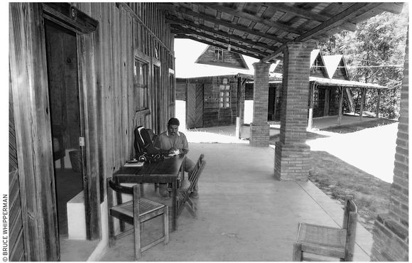
Cabañas ecoturísticas invite an overnight stay in San Sebastian de las Grutas.
The cave you will see is only one of the several partly explored caves honeycombing the mountain, Cerro Cruz del Lado. Its five or six main chambers stretch about 0.5 kilometers (500 yards) into the mountain. Inside, the formations, which include many towering stalagmites and plenty of bulging stalactites, initially appear, in the semi-darkness of the flickering flashlights, to be gargantuan mounds and columns of half-melted vanilla-chocolate-swirl ice cream. However, when your eyes get accustomed to the darkness, many of the formations take on fanciful shapes. Bring your own flashlight and have fun dreaming up your own interpretations instead of merely seeing the guide’s camel, turtle, shark, alligator (which looked like a seal to me), or tiger.
PRACTICALITIES
One could spend two or three enjoyable days hiking, bird-watching, swimming in the creek, sitting in the town plaza, and getting to know the local people. They’re generally friendly, having seen enough visitors that they’re not afraid and don’t think you’re too strange.
Moreover, the local folks are ready for you, with a pair of cozy, rustic wooden cabañas ecoturísticas (tel. 951/488-4640, $25 d, $30 t or q), with hot-water shower-bath, for up to six people in an inviting, forested creekside setting.
The shady streamside park, furthermore, appears ripe for camping ($15), either in your tent or (self-contained) RV. For food and drinking water, bring your own or go to stores in the village (or possibly food stalls near the caves).
Get there by bus via the Trans-Sol or Estrella Rojo del Sureste bus from the camionera central segunda clase next to the Abastos market on the southwest side of Oaxaca City. The Trans-Sol buses, some of which may (ask when you buy the ticket) go right to the caves, leave several times a day, beginning around 6 A.M. The Estrella Rojo del Sureste may only drop you at the intersection, 13 kilometers (eight mi) from the caves. Take a taxi or colectivo van or truck from there. Drivers, follow Highway 131, a total of 76 kilometers (53 mi) south of Oaxaca City. Allow about two hours’ driving time. In the reverse, north direction, the grutas (caves) are 190 kilometers (119 mi) north of Puerto Escondido. For safety, under the best of conditions, allow about four hours of daylight driving time.
Sola de Vega
San Miguel Sola de Vega (pop. 5,000), diminutive capital of the remote, sprawling governmental district of the same name, is the main service stop on Oaxaca–Puerto Escondido Highway 131. The town, 95 kilometers (59 mi) south of Oaxaca City (159 km/99 mi north of Puerto Escondido), presides over a lush mountain-valley checkerboard of corn, cane, and cattle. The lovely sabino-shaded Río Sola de Vega ripples right past the town, crossed by quaint but practical footbridges. It looks as if the people have plenty of fun, spending about half their Sunday afternoons in the water. Informal camping by tent or RV appears seasonally promising in shady spots by the river. Get permission from authorities at the presidencia municipal at the town plaza, about three blocks north from the highway.
If you arrive on Sunday, Sola de Vega’s traditional market day, be sure to visit the local tianguis (native market) around the town plaza.
PRACTICALITIES
A few stores near the plaza can supply basic groceries. For cooked food, the town’s best bet is the 24-hour dining room of the plain but clean Hotel Aguirre (Hwy. 131, tel. 951/574-0046 or 951/574-0047, food $3–8; lodging $15 s, $22 s or d one bed, $31 d, t, q in two beds) on the highway. Its 25 rooms come with private hot-water shower-baths. You will not generally need a reservation, unless you’re arriving late (perhaps after 9 P.M.).
Drivers: Fill up with gasoline at the Pemex station (about a mile north of town), since gasoline is scarce in most of the country along Highway 131. For other essential services, you have the correo (post office), telégrafo, and Internet stores by the plaza; a centro de salud (health clinic) on Independencia, off the plaza; and a private physician, Dr. Vicente Mendoza Martinez, also on Independencia (neither have phones). For nonprescription medicines and phone calls, go to the farmacia-caseta larga distancia San Miguel, right on the highway at the south (Puerto Escondido) end of town. Also on the highway you’ll find the Trans Sol and Estrella Roja del Sureste bus stations.
SOUTHWEST SIDE
 Zaachila
About 16 kilometers (10 mi) south of Oaxaca City, Zaachila (pop. 30,000), like Mitla, overlies the ruins of its ancient namesake city, which rose to prominence after the decline of Monte Albán. Although excavations have uncovered many Mixtec-style remains, historical records nevertheless list a number of Zapotec kings (including the greatest, Zaachila Yoo, for whom the town is named) who ruled Zaachila as a virtual Zapotec capital during the 14th and 15th centuries. Nevertheless, by the eve of the conquest, in the early 16th century, a noble Mixtec minority dominated the Zapotec-speaking inhabitants, whose leaders the Mixtec warriors had sent fleeing for their lives to Tehuántepec.
The big forested hill that rises north of the market plaza is topped by the large, mostly unexplored Zaachila pyramid (8 A.M.–5 P.M. daily, $4). Several unexcavated mounds and courtyards dot the hill’s north and south flanks. The site parking lot and entrance gate are adjacent to the colonial church just north of the plaza.
In 1962, archaeologist Roberto Gallegos (guarded from hostile residents by armed soldiers) uncovered a pair of unopened tombs beneath the summit of the pyramid. They yielded a trove of polychrome pottery, gold jewelry (including a ring still on a left hand), and jade fan handles. Tomb 1 descends via a steep staircase to an entrance decorated with a pair of cat-motif heads. On the antechamber walls a few steps farther are depictions of owls and a pair of personages (perhaps former occupants) inscribed respectively with the name-dates 5-Flower and 9-Flower. Do not miss the bas-reliefs on the tomb’s back wall that depict a man whose torso is covered with a turtle shell. (Tomb 2, although open for inspection, contains no remaining sculptures or inscriptions.)
Hint: The narrow tomb staircase is negotiable by only a few persons at a time and often requires an hour for a tour-bus crowd to inspect it. Rather than waste your time standing in line, go downhill, stroll around the market, and return when the line is smaller. If driving, arrive early, around 9 A.M. on Thursday, to avoid tour-bus crowds. Return in early afternoon, allowing time to visit Cuilapan and Arrazola.
After visiting the archaeological site, you might take a look inside the smallish but robustly buttressed colonial-era Zaachila church, which appears to have been erected atop one of the town’s original pre-conquest ceremonial platforms. Inside, atop the altar, an unusual black Jesus presides above the glass-encased town patron, the Virgin of the Nativity. In her honor, townsfolk stage a big fiesta during the eight days around September 8, which, besides the exhilarating carnival rides, challenging games of chance, tasty food, and flashing fireworks, also features the spectacularly colorful Danza de las Plumas (Dance of the Feathers).
The Thursday tianguis (native market) is Zaachila’s weekly main event. It spreads for blocks below the archaeological site and church. Thousands of Zapotec-speaking country people stream into town to buy, sell, gossip, flirt, and fill up with their favorite delicacies. A few highlights are the luscious, scarlet-red pitacaya (pee-tah-KAHY-yah) fruits, and the foamy-tan tecate (tay-KAH-tay) drink, corn-based and deliciously flavored with chocolate, rosita flower petals, and ground seeds of mamey, all sweetened with brown sugar juice and honey. For a breezy change of pace, hop into one of the buzzing moto-taxis (motorized rickshaws) for a 10-minute jaunt (for about $1.50) around town.
If you’re in the mood for food, wholesome country fare (make sure you get it served hot) is available at the regiment of fondas in the permanent, roofed section of the market. Pork is a Zaachila (“Town of Pork”) specialty, and any one of a small acre of pork stalls will be ready to barbeque a pork chop for you on the spot. Alternatively, enjoy lunch at the showplace  Restaurant La Capilla (tel. 951/528-6115, 7 A.M.–7 P.M. daily, $5–10). Get there on foot or by asking your moto-taxi driver to let you off at La Capilla (kah-PEE-yah), on the main east–west Oaxaca ingress street, a few blocks west of the market.
By bus, get to Zaachila via Autobuses de Oaxaca, from the camionera central segunda clase in Oaxaca City, or by private tourist bus. By car from Oaxaca City, head south from downtown to the periférico. Do not continue south via the airport Highway 131–175. Instead, from the periférico a block west of the airport-highway intersection (watch for the Monte Albán sign), follow the four-lane boulevard that angles southwest, away from the periférico, across the Río Atoyac bridge. Just after crossing the bridge, do not continue straight ahead toward Monte Albán, but take the second left (south) onto the old (scenic route) Zaachila road, which also passes Cuilapan de Guerrero and Arrazola. (Note: The first left fork heads along the no-nonsense—but at this writing, potholed—highway, in a straight four-lane bee-line toward Zaachila, bypassing Cuilapan de Guerrero and Arrazola.)
Cuilapan de Guerrero and Arrazola
Southwest of Oaxaca City, on the old road between Zaachila and Arrazola, Cuilapan de Guerrero is famous for its elaborate but unfinished Ex-Convento de Santiago (Saint Jame, 9 A.M.–5 P.M. daily). It’s visible from the Oaxaca City–Zaachila Highway (via Xoxocotlan). This is where Vicente Guerrero, father of the Mexican republic, was infamously executed in 1831. Although construction began in 1535, the cost of the basilica and associated monastery began to balloon. In 1550, King Philip demanded humility and moderation of the builders, whose work was finally ended by a 1570 court ruling. The extravagances—the soaring, roof less basilica, magnificent baptismal font, splendid Gothic cloister, and elaborate frescoes—remain as national treasures.
Arrazola, a few miles farther north, toward Oaxaca City, is one of the sources (along with San Martín Tilcajete) of the intricately painted alebrijes (ah-lay-BREE-hays)—fanciful wooden creatures that decorate the shelves of handicrafts shops all over Mexico and foreign countries. Bus travelers: Get there either by second-class bus or by tourist bus from Oaxaca City. Drivers: Turn west (left) onto signed Highway 145 a few miles north of Cuilapan de Guerrero or, traveling south, turn right 5.1 kilometers (3.2 mi) south of the Río Atoyac bridge in Oaxaca City. Pass through San Javier village and continue from the turnoff a total of five kilometers (three mi) to the Arrazola town plaza. Turn right immediately before the plaza onto Calle E. Zapata and turn left after one block, at Independencia. After one more block you will be at Calle Obregón, where everyone seems to be making alebrijes. Although you should visit a number of family workshops along the street, be sure to visit Pepe Santiago (no phone, 10 A.M.–6 P.M. daily) and his Santa’s workshop of craftspeople. Inside the Santiago compound (on the right, just below the hilltop), men and boys saw and carve away while a cadre of young women and girls painstakingly add riots of painted brocade to everything from whimsical dragons and gargoyles to armadillos, giraffes, and rabbits.
West Side: The Archaeological Route
Although all of these interesting destinations are readily reachable from Oaxaca City, they are far too rich to be visited in a single day. As a minimum, be sure to visit Monte Albán, which can be conveniently combined with a side trip to Atzompa. On another day, preferably a Wednesday, visit the Etla market, with stops at the community museums and key archaeological sites at El Mogote and Suchilquitongo nearby.
 MONTE ALBÁN
Monte Albán ranks among Mesoamerica’s most regally spectacular ruined cities. Known in ancient times by its Zapotec name, Danni Dipaa, the site’s present “Monte Albán” label was probably coined by a local Spaniard because of its resemblance to a similarly named Italian hilltop town.
Monte Albán’s original inhabitants cultivated beans, chilies, corn, fruits, and squash on the hillsides and in adjacent valleys, occasionally feasting on meat from deer, small game, and perhaps (as did other native Mexicans) domesticated dogs. Tribute from surrounding communities directly enriched Monte Albán’s ruling classes and, by extension, its artisans and farmers.
The great city atop the hill reigned for at least 1,200 years, between 500 B.C. and A.D. 750, as the capital of the Zapotecs and the dominant force between Teotihuacán in the Valley of Mexico and the Maya kingdoms of the southeast. Archaeologists have organized the Valley of Oaxaca’s history from 500 B.C. to the conquest into five periods, known as Monte Albán I–V. Over those centuries, the hilltop city was repeatedly reconstructed with new walls, plazas, and staircases, which, like layers of an onion, now overlie earlier construction.
Remains from Monte Albán Period I (500 B.C.–A.D. 1) reveal an already advanced culture, with gods, permanent temples, a priesthood, a written language, numerals, and a calendar. Sharply contrasting house styles indicate a differentiated, multilayered society. Monte Albán I ruins abound in graceful polychrome ceramics of uniquely Zapotec style.
Concurrent Olmec influences have also been found, notably in the buildings known as the Danzantes (Dancers), decorated with unique bas-reliefs similar to those unearthed along the Veracruz and Tabasco coasts.
The people who lived during Monte Albán Period II (A.D. 1–300), by contrast, came under heavy influence from Chiapas and Guatemala in the south. They built strange, ship-shaped buildings, such as Monte Albán’s mysterious Building J, and left unique remains of their religion, such as the striking jade bat-god now on display in the Anthropology Museum in Mexico City.
Monte Albán reached its apex during the classical Period III (A.D. 300–800), attaining a population of perhaps 40,000 in an urban zone of about eight square kilometers (three sq mi), which spread along hilltops (including the El Gallo and Atzompa archaeological sites) west of the present city of Oaxaca.
Vigorous Period III leaders rebuilt the main hilltop complex as we see it today. Heavily influenced by the grand style of the Teotihuacán structures in the Valley of Mexico, the buildings were finished with handsome sloping staircases, corniced walls, monumental carvings, ball courts, and hieroglyph-inscribed stelae depicting gods, kings, and heroic scenes of battle.
By A.D. 750, few foreign influences were continuing to enrich Monte Albán’s uniquely Zapotec pottery styles. Quality declined until they seemed like mere factory copies. Concurrently, the Zapotec pantheon expanded to a horde of gods, as if mere numbers could protect the increasingly isolated Valley of Oaxaca from the outside world.
In A.D. 800, Monte Albán, mysteriously cut off from the rest of Mesoamerica, was declining in population and power. By A.D. 1000, the city was virtually abandoned. The reasons—whether drought, disease, or revolt—and the consequent loss of the necessarily imported water, wood, salt, and food supplies remain an enigma.
During Periods IV and V, Mixtec peoples from the north invaded the Valley of Oaxaca. They warred with valley Zapotecs and, despite their relatively small numbers, became a ruling class in a number of valley city-states. The blend of Mixtec and Zapotec art and architecture sometimes led to new forms, especially visible at the west valley sites of Yagul and Mitla.
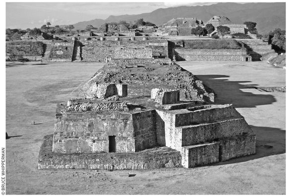
Monte Albán’s enigmatic Building J, foreground
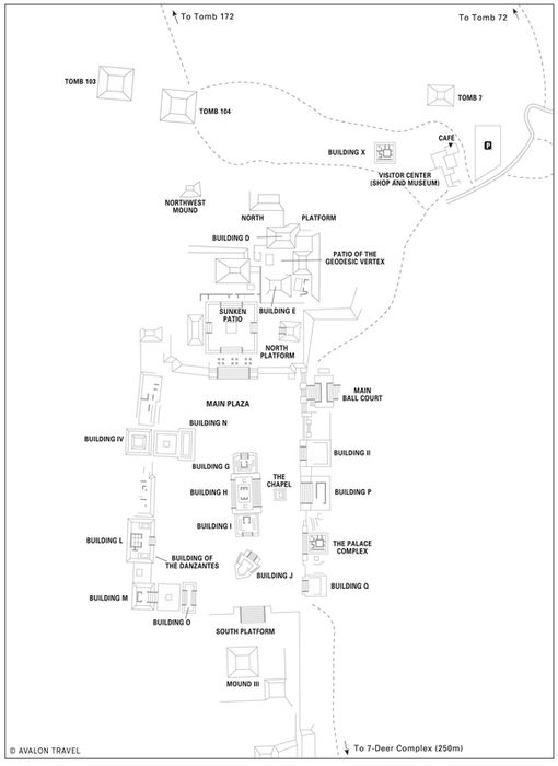

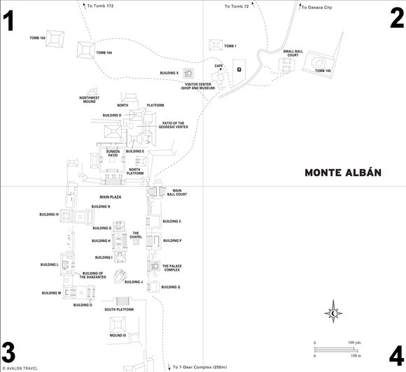
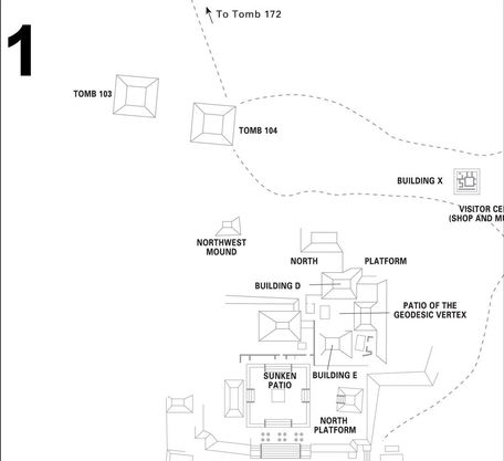
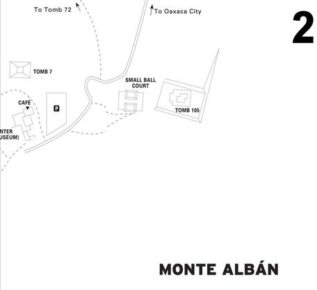
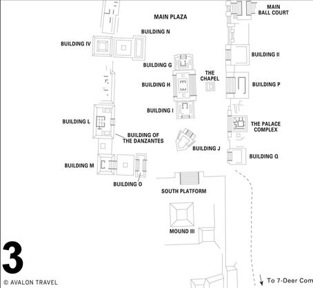
Monte Albán, meanwhile, although abandoned, was not forgotten. It became both a refuge and a venerated burial place. In times of siege, local people retreated within the walls of a fortress built around Monte Albán’s South Platform. At other times, Mixtec nobles opened tombs and reused them as burial vaults right up until the eve of the conquest.
Exploring the Site
Visitors to Monte Albán (tel. 951/516-9770, 8 A.M.–5 P.M. daily, entrance $5) enjoy a panoramic view of green mountains rising above the checkerboard of the Valley of Oaxaca. Monte Albán is fun for a picnic; alternatively, it is an auspicious place to perch atop a pyramid above the grand Main Plaza, etched by lengthening afternoon shadows, and contemplate the ages. Allow at least two hours for your visit.
A good guide (about $10 pp for a two-hour tour) can certainly enhance your Monte Albán visit. Many are licensed by the authorities. You can often hire someone on the spot. Or, make an appointment with one of the best: very knowledgable and English-fluent Juan Carlos Peralta (cell tel. 044-951/103-4004, guiasjuan@hotmail.com).
Past the visitor’s center, as you enter the Main Plaza, north will be on your right, marked by the great North Platform, topped by clusters of temples. The Ball Court will soon appear on your left. Twenty-foot-high walkways circumscribe the sunken I-shaped playing field. To ensure true bounces, builders spread smooth stucco over all surfaces, including the slopes on opposite sides (which, contrary to appearances, did not seat spectators). This, like all Oaxacan ball courts, had no stone ring (for supposed goals), but rather four mysterious niches at the court’s I-end corners.
The Main Plaza, 1,000 feet long and exactly two-thirds that wide, is aligned along a precise north–south axis. Probably serving as a market and civic/ceremonial ground, the monumentally harmonious Main Plaza was the Zapotec “navel” of the world.
Monte Albán’s oldest monumental construction, the Danzantes building (surmounted by newer Building L, on the west side of the plaza between Buildings M and IV), dates from Period I. Its walls are graced with a host of personages, known commonly as the danzantes (dancers) from their oft-contorted postures—probably chiefs vanquished by Monte Albán’s armies. Their headdresses, earplugs, bracelets, and necklaces mark them among the nobility, while glyphs around their heads identify each individual.
Building J (circa A.D. 1), one of the most remarkable in Mesoamerica, stands nearby in mid-plaza at the foot of the South Platform. Speculation has raged since excavators unearthed its arrow-shaped base generations ago. It is not surprising that Alfonso Caso, Monte Albán’s original principal excavator, theorized it was an astronomical observatory (perhaps since it does point in the direction of the setting sun at its winter solstice).
See THE TRAGIC STORY OF PRINCESS DONAJI
In the mind’s eye, however, it seems like some fantastic ocean (or space?) vessel, being navigated to some mysteriously singular southwest destination by a ghostly crew oblivious of its worldly, earthbound brother monuments.
Aficionados can’t resist claiming that Building J represents some other-worldly influence. They assert that the figure, visibly inscribed on the building’s upper northwest corner, is an extraterrestrial wearing a space helmet. Expert professionals refute this with a more earthly explanation, that the figure simply represents a ball player wearing the customary protective leather helmet.
The South Platform affords Monte Albán’s best viewing point, especially during the late afternoon. Starting on the right-hand, Palace-complex side, Building II has a peculiar tunnel on its near side, perhaps covertly used by priests for privacy or some kind of magical effect. To the south stands Building P, an undistinguished, albeit multi-room palace.
The South Platform itself is only marginally explored. Looters have riddled the mounds on its top side. Its bottom four corners were embellished by fine bas-reliefs, two of which had their engravings intentionally buried from view. You can admire the fine sculpture and yet-undeciphered Zapotec hieroglyphs on one of them, along with others, at the South Platform’s plaza-edge west side.
Still atop the South Platform, turn southward, where you can see the Seven-Deer complex, a few hundred yards away, labeled for the name-date inscribed on its great lintel.
Turning northward again, look just beyond Building J to Buildings G, H, and I at the plaza center, erected mostly to cover a rocky mound, impossible to remove without then-unavailable dynamite. Between these buildings and the palace complex on the right stands the small chapel where the remarkable bat-god jade sculpture was found.
On Monte Albán’s northern periphery stand a number of tombs that, when excavated, yielded a trove of artifacts, now mostly housed in museums. Walking west from the Northern Platform’s northeast base corner, you will pass Mound X on the right. A few hundred yards farther comes the Tomb 104 mound, presided over by an elaborate ceramic urn representing Cocijo, the Zapotec god of rain. Just north of this is Tomb 172, which has its skeletons and offerings left intact when it was first opened.
Heading back along the northernmost of the two paths from Tomb 104, you will arrive at Tomb 7 a few hundred feet behind the visitors center. Here, around 1450, Mixtec nobles removed the original eighth-century contents and reused the tomb, burying a deceased dignitary and two servants for the netherworld. Along with the bodies, they left a fabulous treasure in gold, silver, jade, alabaster, and turquoise, now visible at the museum at the Centro Cultural de Santo Domingo in Oaxaca City.
A few hundred feet toward town on the opposite side of the road from the parking lot is a trail leading past a small ball court to the Cerro de Plumaje (Hill of Plumage), site of Tomb 105. A magnificent entrance door lintel, reminiscent of those at Mitla, welcomes you inside. Past the patio, descend to the mural-decorated tomb antechamber. Inside the cruciform tomb itself, four figures walk in pairs toward a great glyph, flanked by a god and goddess, identified by their name-dates.
Visitors Center
The Monte Albán Visitors Center (tel. 951/516-9770, 8 A.M.–5 P.M.) has an excellent museum, good café with airy terrace, and information counter. Also, a well-stocked store offers many books—guides, histories, art, folklore—on Mesoamerica. First, take a look inside the museum, which displays a number of Monte Albán’s famous finds. Most notable are several of the original danzantes monolith reliefs, recognizable by their mutilated genitals.
In the bookstore (tel. 951/516-9180), you might purchase a copy of the very useful Guide to Monte Albán, by Monte Albán’s director, Neli Robles. You could also pick up a copy of the very authoritative, in-depth Oaxaca, the Archaeological Record, by archaeologist Marcus Winter, that covers many Oaxaca archaeological sites, including the valley sites of Dainzu, Lambityeco, Mitla, San José El Mogote, Suchilquitongo, and several other important sites in the Mixteca.
Getting There
Get to Monte Albán economically and very conveniently by one of the several tourist buses, run respectively by Hotel Rivera del Ángel (Mina 518, tel. 951/516-6666), and Viajes Turísticos Mitla (Mina 501, tel. 951/516-5327). Find them three blocks south and four blocks west of the zócalo in Oaxaca City.
By car, get to Monte Albán via the most scenic route. Start from Oaxaca City’s south side, at the periférico, about a mile due south from the zócalo past the end of southbound Calle M. Cabrera. At the periférico, watch for a Monte Albán sign. Cross the periférico, then bear right (southwest) and immediately cross over the Río Atoyac bridge. Continue ahead, following other Monte Alban signs, about eight kilometers (five mi), uphill, to Monte Albán.
Alternatively, get to Monte Albán by following Highway 190 northwest from downtown Oaxaca City. After just about three kilometers (two mi) from the city center (look for a Monte Albán sign), curve left, around the big monument and traffic circle, reversing your direction, then immediately turn right (west) and continue across the Río Atoyac bridge. Follow the signs about 10 more kilometers (six mi) uphill to Monte Albán.
SANTA MARÍA ATZOMPA
The present-day town of Santa María Atzompa (pop. 5,000) spreads over the western end of the greater Monte Albán archaeological complex, overlying hundreds of acres of unexplored ancient remains. The majority of modern Atzompans, however, have little time for the past. They are busy producing their distinctive pottery creations—attractive emerald green–glazed cooking pots, bowls, baking dishes, plates, and more—famous all over Mexico and the world.
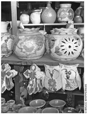
pottery selection, Atzompa Mercado de Artesanías
Now, however, they make much more than these, having developed a host of new styles such as multicolored vases, some with artfully cut holes for placing dried or fresh flowers, as well as lily-adorned crosses, vases, plates, and red pottery, inscribed with fetching floral motifs.
Atzompa’s artists, moreover, make it very easy to select from their wares, with an inviting Mercado de Artesanías (Handicrafts Market, tel. 951/558-9232, or local cell tel. 044-951 516-5062, 9 A.M.–7 P.M. daily), on the entrance road (right side) after a long initial lineup of private stores. Each of the mercado displays contains the name and address of the artist, whom you can contact nearby in town. (Note: Recently, some artists have been trying harder, building individual stores on the road before the official Mercado de Artesanías. For the best selection, however, pass these and go straight to the official market.)
For lunch at the handicrafts market, try the adjacent, airy  Restaurant Patio (11 A.M.–6 P.M. daily, $4). They offer an inviting menu of many Mexican country specialties, including a number of moles (with chicken) and the reliable favorite, chiles rellenos.
Atzompa Archaeological Zone
The line of hilltops stretching west from Monte Albán to Atzompa is peppered with buried pyramids, ceremonial plazas, and ball courts. Archaeologists have recently been investigating the hilltop above Atzompa. They have excavated a mound (known locally as el mogote) and partly restored a regal platform and pyramid. At this writing, they’re not yet welcoming visitors, but a visitor’s center and museum are in the works.
Get there by taxi, car, or on foot, climbing main Atzompa street Calle Independencia (the first street past the Mercado de Artesanías). Turn left and continue uphill about a mile to the visitor’s center and parking lot.
Get to Atzompa by bus, from the Abastos camionera central segunda clase in Oaxaca City, or by car, heading northwest out of town, along the Highway 190 exit boulevard in the direction of Mexico City. After about three kilometers (two mi) from the city center, follow the Monte Albán sign, bearing left around the traffic circle, which heads you momentarily back toward town. Immediately turn right, cross the Río Atoyac bridge, and continue for 0.8 kilometers (0.5 mi), turning right (north) at an Atzompa-signed intersection. Continue another four kilometers (2.5 mi) to the Mercado de Artesanías and the restaurant on the right.
 SAN JOSÉ EL MOGOTE
Finds uncovered at San José El Mogote have shed considerable light on Valley of Oaxaca prehistory, especially during the thousand-year period preceding the founding of Monte Albán, around 500 B.C. Remains reveal that San José El Mogote was founded around 1500 B.C. and developed into a sophisticated center, with factory workshops supervised by elite merchants, which manufactured mica mirrors and jewelry for local and regional trade.
Old San José El Mogote lives on, literally, in the backyards of its present Zapotec residents. The people had forgotten what was buried in the seven or eight mogotes (mounds) dotting their village. From the pottery shards littering their fields, however, they suspected something was buried beneath the mounds. Archaeologists came and dug up the treasures now displayed in the community museum.
Museum
San José El Mogote people take justifiable pride in their museum, the Hacienda del Cacique, housed in a gorgeously restored old hacienda, the former ranch home of a local founding cacique (political boss) family. Its intriguing displays include shell jewelry, ceramic and stone burial offerings, a reconstructed tomb, a pre-Columbian adobe wall, a photo of a danzante (dancer) monolith (still situated in the ruins) like those found at Monte Albán, and exquisite ceramic sculptures. Outstanding among these is the amazing diablo enchilado, with a half-scowling, devilish grin, exactly like a scary red Halloween demon.
Note: The museum’s hours are irregular. If you arrive unannounced, you may find the museum closed. However, someone is usually in charge, and, if available, he or she will open it for you. To inquire, say (or point to) this phrase “¿Donde está el encargado del museo?” (“Where is the person in charge of the museum?”) The presidencia municipal (town hall) is usually the best place to make your inquiry.
Exploring the Site
The archaeological zone consists of eight mounds in all, which extend over a local half-mile square. Only one of them, the biggest, immediately behind the museum, has been extensively explored. Climb its reconstructed stone staircase to a broad courtyard. On the courtyard’s north side is an excavated shaft, customarily locked, with the danzante (dancer) monolith at its bottom. Climb the regal, stair-stepped pyramid adjoining the courtyard. At the summit, you can glimpse the other mounds, scattered near and far. Most notable among these is a partly excavated ball court, a five-minute walk to the northwest, once used for the pelota mixteca ball game, which is still played locally.
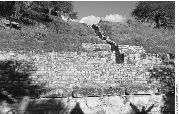
the ancient restored staircase at San José El Mogote
Farther afield, a 10-minute walk to the southwest side of the zone past a modern but now unused stone era (threshing circle), local people can lead you to a corrugated iron roof that shelters the stone foundation of what archaeologists believe to be an elite family house.
While exploring the site, you may see a scattering of tiny yellow daisies. Local folks call this yerba de conejo (herb of the rabbit). They take it as a tea, or mixed with beans, especially before siestas. Some say that its aphrodisiac effect is indeed potent.
Festival of San José
Arrive during the third week in March and join in the fun of the patronal festival of San José, which climaxes on the weekend closest to March 19. Festivities include processions, fireworks, dances of giant figures (called monos or marmotas), and a pelota mixteca tournament. While at the museum, ask the volunteers to show you the hule (natural rubber) ball and the leather mitts currently used to play the game.
Getting There
You can reach San José El Mogote in a number of ways. The easiest way is to go by tour or taxi from downtown Oaxaca City. You can also go solo by second-class bus from the camionera central segunda clase, just north of Abastos market. Catch the Choferes del Sur bus to Nazareno town. Alternatively, you can catch a colectivo on the prolongation of V. Trujano, which runs along the north side of the second-class bus station.
Drivers: Head north along Highway 190 out of Oaxaca City. About 12 kilometers (7.5 mi) from downtown, at the fork to the new cuota autopista, stay on the libre (free) old route. After about three kilometers (two mi), turn left (west) at the San José El Mogote (also Nazareno) side road (marked by the pyramid archaeological symbol sign). Pass over the railroad tracks, continue 0.8 kilometers (about 0.5 mi), and at the bus stop shelter, turn left. Continue to the museum just past the water towers on the left.
SIDE TRIP TO SAN AGUSTÍN ETLA
Renowned Oaxaca artist Francisco Toledo encourages the public to visit and support hillside art center that he, with others, founded in 1999. His efforts continue to fulfill his goal of inspiration, education, and encouragement of art appreciation in his native state of Oaxaca. Toledo, now over 70, was honored with the Mexico National Prize in 1998 in recognition of his work (which included the Oaxaca Institute of Graphic Arts and the Museum of Oaxaca Contemporary Art in Oaxaca City).
You can view some results of his work in the suburban village of Vista Hermosa, above small San Agustín Etla town. First you arrive at the factory-shop of Arte Papel Vista Hermosa (tel./fax 951/521-2394, 9 A.M.–5 P.M. Mon.–Fri., 9 A.M.–2 P.M. Sat.), with an airy showroom in an antique high-ceilinged former power-generating house. Overhead a festoon of colorful paper banners hang like kites in the wind, while in a next-door rear workshop a cadre of young artisans diligently execute Toledo’s sometimes whimsical, but sometimes stark, graphic designs-in-paper.
Up the hill two blocks, find the Centro de Artes San Agustín (Calle Indepencia, tel. 951/521-3042, 951/521-3043, or 951/521-2574, www.casanagustin.org, 9 A.M.–6 P.M. daily), the art exhibition hall and educational center. The main building resembles a Greek temple much more than the cotton-weaving mill that it once was. There’s an expansive pond surrounding a massive iron boiler—the only hint of the site’s former identity.
San Agustín Etla makes a good side trip from San José Mogote (it’s about 20 minutes by car or taxi), and can also be combined with a visit to Etla. On Highway 190, drive shortly past the San José El Mogote exit (archaeological sign on left), to a paved road (watch for a Vista Hermosa sign) on the right. Turn right and continue uphill for about 7.2 kilometers (4.5 mi), to the paper factory (fábrica de papel) on the right.
To get there from Oaxaca City, start at the second-class bus station, much like going to San José El Mogote. Ask the Choferes del Sur bus driver to let you off at the branch road to San Agustín Etla, from Highway 190. Ride a taxi or collective taxi from there the 6.4 kilometers (four mi) to Vista Hermosa.
ETLA
The name Etla strictly refers to a county-size district northwest of Oaxaca City that contains a number of small towns (such as Soledad Etla, San Miguel Etla, and San Gabriel Etla) that cluster around the central hub town of San Pedro y San Pablo Etla, site of the famous Etla Wednesday market. Consequently, this is the place that most folks refer to simply as Etla (or sometimes Villa de Etla). Although the Etla Wednesday market invariably has stalls overflowing with its celebrated “Oaxaca” (but more correctly “Etla”) cheese, vendors offer plenty of other old-fashioned merchandise. How would you like, for example, some fresh sheepskins, burro pack frames, green Atzompa pottery, or banana-leaf-wrapped red Oaxaca tamales? The market’s main attraction, however, is the battalion of native country women offering mounds of carrots, forest-gathered herbs, nopal cactus leaves, onions, and much more.
For food, either pick one of the platoon of very clean fondas (food stalls) on the upper level of the main market, or head outside, to country-style comedor  La Fonda (no phone, 8 A.M.–7 P.M. daily, $2–5), adjacent to the market’s southeast side. Elderly Señora Julia both cooks and directs a bustling cadre of helpers in serving up a wholesome menu of homemade breakfasts, sopas (soups), and guisados (stews), all served up with generous portions of rice and beans and steaming stacks of handmade tortillas. Alternatively, try Restaurant Chefy (8 A.M.–8 P.M. daily, $3–8) for a wholesome, home-style breakfast or lunch, on the left side of the main street as you enter town from the highway.
Get to Etla much as you would get to San José El Mogote. Preferably arrive at the market by about 10 A.M. to allow time for visits to San José El Mogote, Suchilquitongo, and/or San Agustín Etla later. By bus from Oaxaca City: Ride a Choferes del Sur Etla–marked bus from the camionera central segunda clase, or a colectivo from the north side of the bus station.
By car: Head north along old libre (toll-free) Highway 190 for about 15 kilometers (nine mi) from the center of Oaxaca City and turn left at the big green Etla sign above the highway. The market is the prominent light-yellow cantera stone building, uphill from the rail station, about 0.4 kilometers (0.25 mi) from the highway.
SUCHILQUITONGO AND CERRO DE LA CAMPANA ARCHAEOLOGICAL ZONE
Suchilquitongo
Before heading uphill to investigate the important Cerro de la Campana archaeological zone, look around the nearby Suchilquitongo town plaza. Suchilquitongo (“Place of Flowers” in the Mixtec language; pop. 5,000) is the seat of the surrounding Suchilquitongo municipio, a rich domain of hills and mountains enclosing the emerald vale of the upper Río Atoyac. Using irrigation, bottomland farmers routinely bring in three crops per year, achieving some of Mexico’s highest yields per acre in corn, beans, alfalfa, and squash. If only the rest of Oaxaca were so productive. Although virtually all of the bottomland is privately owned, much of the surrounding hills and mountains are undeveloped town communal pasturelands.
The Suchilquitongo Museo Comunitario (Community Museum; no phone, but check with the presidencia tel. 951/528-4616, 10 A.M.–2 P.M. and 4–8 P.M. Tues.–Sun.) is on the town plaza. It’s one of best of the network of community museums sprinkled around the state, with artifacts, reproductions, and an actual-size mock-up model of the famous Tomb 5, discovered in the Cerro de la Campana archaeological zone in 1985. A glance at the archaeological displays reveals why it’s considered the most important Zapotec city-state tomb uncovered to date. It was literally a house of the dead, with the remains of about 20 noble personages from at least three generations, with calendrical birth names, such as 5-Earth, 5-Serpent, and 12-Monkey. Before the excavation, they lay at rest in a massive three-room, 15-foot-deep crypt complex among piles of jewelry, supplied with elaborate goods for the afterlife, and surrounded by bright murals of ceremonial scenes, including a grand procession of feathered and helmeted ball players. Before you leave the Tomb 5 mock-up, be sure to see the Sphere of Day and Night, and the richly engraved columns and tomb entrance door, both embossed with as-yet-untranslated Zapotec glyphs.
Another museum room illustrates the Spanish-Mexican custom of mayordomía, as acted out by Suchilquitongo people for their major fiesta, the July 22–27 fiesta of Santiago (St. James). Everyone participates—cooking food, making costumes, rehearsing for the dancing, setting up ramadas (temporary roofs) for shade, spiffing up the church, donating money—especially the mayordomo, the man or woman nominated by the presidente municipal and approved by a grand church meeting of the entire community to head all this up. The mayordomo, nearly always a person of means, usually ends his or her term of office poorer, but rich with community affection and prestige.
Before you leave Suchilquitongo, you might want to visit one of the town’s basket weavers at work. For a small fee, maybe the equivalent of a couple of dollars, the person at the museum desk may be able to guide you (or find someone who can) to one of their workshops.
Suchilquitongo’s other significant craft is stonemasonry. Local quarries mine three types—morada (pink), blanco (meaning white, but actually a pale green), and amarillo (pale yellow)—of the soft cantera (volcanic tufa) for which Oaxaca is famous. As you exit at the highway, go left a few hundred yards, and on the right you’ll see the covered workshop of master stonemason Cenobio Ausencio Pinelo Martínez (tel. 952/528-4569), who is teaching his sons his disappearing craft.
Exploring Cerro de la Campana
From the town plaza, you can see the Cerro de la Campana cluster of hilltops above the northern horizon. The site is about a three-kilometer (two mi), 150-meter (500 ft) climb. If it’s hot, hire a taxi. If not, be sure to wear a hat, sturdy shoes, and take water. Atop the hill, you’ll find Tomb 5 (hopefully open to the public after years of restoration), a ball court, three courtyards, and three partly restored pyramids.
After you arrive atop the hill, look closely at the knolls in the immediate vicinity and you’ll see that they too are topped by pyramids, approximately 20 in all. Also, as you walk next to a road-cut section of hillside, look carefully and you’ll be able to spot and examine 1,500-year-old pottery shards.
Climb to the highest—the cross-topped—pyramid, and your reward will be a breezy view of the entire Etla Valley and mountain panorama. Notice the dark Monte Albán ridge, far to the southeast, to the right of distant Oaxaca City (below the Cerro San Felipe massif on the left). You can immediately see Cerro de la Campana’s advantages: direct signal-fire communication with its contemporary, Monte Albán; a strong defensive position; and fertile riverbank fields. Why it was abandoned, like Monte Albán, around A.D. 800, remains a puzzle for future generations of archaeologists to decipher from the bones, stones, and mute, mysterious glyphs Cerro de la Campana’s builders left behind.
Getting There
Get to Suchilquitongo by bus via one of the Cooperativo de Autobuses Suchilquitongo buses, which leave from the camionera central segunda clase just north of the Abastos market in Oaxaca City, west of the periférico. Alternatively, you can go by a Suchilquitongo-bound colectivo on the prolongation of V. Trujano, which runs along the bus station’s north side.
Drivers: Head out of Oaxaca City along Highway 190 in the direction of Mexico City, northwest. Bear right onto libre (toll-free) Highway 190 where the cuota autopista (toll expressway) splits off to the left, about 12 kilometers (7.5 mi) from the city center. Continue another several kilometers along libre Highway 190, pass an industrial park entrance on the left and, within a few minutes, turn left 27 kilometers (17 mi) from the city center at the big Suchilquitongo entrance arch on the left. Pass over the railroad tracks and continue straight ahead to the Community Museum, another 0.8 kilometers (0.5 mi) to the town plaza. Climb the plaza stairway on the right to the museum.
For the Cerro de la Campana archaeological zone, return to the railroad tracks, where Calle Victoria forks left, uphill north, passing a church, continuing a total of about 2.5 kilometers (1.5 mi) to the hilltop archaeological zone.
COMMUNITY MUSEUMS
Oaxaca’s many community museums (museos comunitario) provide visitors with a potentially rewarding alternative for getting to know local people. The museums, which now number about 20, sprinkle the Valley of Oaxaca, the Mixteca, and the Pacific coast. The first community museums began as a result of archaeological digs. Later museums arose from the local need to house historic community documents and the myriad artifacts that folks have been digging up in their own backyards for centuries.
During the 1980s and 1990s, the government funded the construction of museums and installation of exhibits in a number of indigenous communities, in both the Valley of Oaxaca and the Mixteca. Now, excellent small museums in the communities of Teotitlán del Valle and Santa Ana del Valle, in the east Valley of Oaxaca, and San José El Mogote and Suchilquitongo, in the northwest valley, welcome visitors during regularly maintained hours.
The same is more or less true for the well-organized Mixteca museums in Huajuapan de León, San Pedro y San Pablo Tequixtepec, Huamelulpan, and Tututepec on the Mixtec Coast.
A number of other small communities also established museums but do not yet maintain regular hours. Nevertheless, local contact people are available to open their museums for visitors. In the Valley of Oaxaca, such museums exist at San Pablo Huixtepec (on Hwy. 131, south of Zimatlán) and San Pablo Huitzo (northeast, off of Hwy. 190). The same is true in the Mixteca for the communities of Yucuita, San Miguel Tequixtepec, Tepelmeme de Morelos, San José Progeso, San Juan Mixtepec, Santa María Cuquila, and Santa María Yucuhiti.
REACHING OUT
By establishing museums for public viewing, the communities are reaching out as never before. Your interest in visiting them will most likely be seen as a compliment by the local people. If you’re interested in seeing more than just the museum, ask the museum attendant to suggest a guide who can show you around. Most of these museums have regular guides who are available to lead visitors to notable local sites, such as ruins, sacred caves, lakes, springs, mountain summits, and artisans’shops.
Always volunteer to pay–donar al museo (donate to the museum)–for such services. If necessary, be sure to bring along your own English-speaking guide or a Spanish-speaking friend to interpret.
For details, see museum information in the individual community sections. Also, you might contact Oaxaca state tourism (Av. Juárez 703, west side of El Llano park, Oaxaca City, tel. 951/516-0123, www.aoaxaca.com, info@aoaxaca.com, 8 A.M.–8 P.M. daily).
TOWN NAMES
Town names in Oaxaca (and in Mexico) generally come in two pieces: an original native name accompanied by the name of the town’s patron saint. Very typical is the case of San Jerónimo Tlacochahuaya, a sleepy but famous little place. Combining both the saint’s name (here, San Jerónimo) and the native name (here, Tlacochahuaya) often makes for very unwieldy handles; so, many towns are known only by one name, usually the native name. Thus, in the west side of the Valley of Oaxaca, San Jerónimo Tlacochahuaya, Santa María del Tule, Tlacolula de Matamoros, and San Pablo Villa de Mitla, for example, are commonly called Tlacochahuaya, El Tule, Tlacolula, and Mitla, respectively.
Nevertheless, sometimes a town’s full name is customarily used. This is especially true when a single name–such as Etla, northwest of Oaxaca City–identifies an entire district, and thus many towns, such as San Agustín Etla, San Sebastián Etla, and San José Etla, must necessarily be identified with their full names. In this book, although we may mention the formal name once on a map or in the text, we generally conform to local, customary usage for town names.
THE MYSTERY OF MITLA’S FRISSELL MUSEUM
The Frissell Museum (a block west of the town entrance road, by the Mitla town plaza) has been closed since 1995, presumably for remodeling. Even worse, sometime between 1995 and 2007, the museum’s entire priceless 40,000–80,000 piece collection (such as masterfully carved ceramic figurines, yet-to-be-deciphered Zapotec glyphs, and a Zapotec marriage certificate in stone) disappeared. Local folks shake their heads when they sadly report that none of the stolen artifacts have yet been recovered.
Besides its collection, the museum’s venerable hacienda-style home is notable in its own right. From the mid-19th century, as the Posada La Sorpresa, it served as a lodging, owned and operated by the longtime local Quero family. In 1950, they sold it to American artifact collector Edwin R. Frissell, who turned the hotel into both his home and a repository for his growing collection and that of his friend, Howard Leigh, noted scholar of Mixtec language and culture. Upon their deaths, the entire building and artifact collection passed to the Mexico City University of the Americas.
In 2001, Mitla residents, notably Rufino A. Quero, descendant of the historic owners, suspected foul play and hired attorneys to investigate. By 2007 they had gathered enough evidence to denounce the “sacking” of the collection and hinted that Oaxaca state officials were responsible. In 2008, they filed legal charges, and in 2009 a group of local residents petitioned the National Institute for Archaeology and History (INAH) to return at least 30 percent of the collection. Meanwhile, local folks wait and hope that their cherished, lost legacy will someday be returned home.
BUILDING CHURCHES
Although European architects designed nearly all of Mexico’s colonial-era churches, embellishing them with old-world Gothic, Renaissance, baroque, and Moorish decorations, native artists blended their own geometric, floral, and animal motifs. The result was a hybrid that manifested in intriguing variations all over Mexico. This was especially true in Oaxaca, where faithful droves worship before gilded altars and flowery ceilings built and decorated by their long-gone ancestors. Local materials further distinguish Oaxacan churches from others in Mexico. The spectrum of soft pastels of local cantera volcanic stone, from yellow through gray, including green in Oaxaca City, marks Oaxacan walls and facades.
Sometimes the native influence led to poor (“provincial”) versions of European designs; other times (notably, the Templo y Ex-Convento de Santo Domingo in Oaxaca City), artists merged brilliant native decorations with the best of European-style vaults, arches, and columns.
THE LAYOUT
Mexican church design followed the Egypto-Greco-Roman tradition of its European models. Basically, architects designed their churches beginning with the main space of the nave, in the shape of a box, lined with high lateral windows. Depending on their origin and function, the churches fit into three basic groups–the monk’s convento (monastery or convent), the bishop’s catedral (cathedral), and the priest’s templo or parroquia (parish church). Most Oaxacan monastic churches (nearly all now ex-convents) were begun during the 16th and 17th centuries by the missionary orders–ahandful by the Franciscans, Jesuits, and Augustinians, and the overwhelming remainder by the Dominicans.
In Oaxaca, faced with the constant threat of earthquakes, the Dominican padres built massively thick walls supported on the exterior with ponderous buttresses. Key elements were naves, with or without cruceros (transepts), cross spaces separating the nave from the altar, making the church layout resemble a Christian cross. They placed the coro (choir) above and just inside the entrance arch.
At the opposite, usually east (or sunrise) end of the church, builders sometimes extended the nave beyond the transept to include a presbiterio (presbytery), which was often lined with seats where church officials presided. The building ended past that at the ábside (apse), the space behind the altar, frequently in semicircular or half-octagonal form. Within the apse rose the gilded retablo (retable or altarpiece) adorned with sacred images, attended by choirs of angels and cherubs.
Larger churches usually incorporated side altars presided over by images of locally popular saints, nearly always including the Virgin of Guadalupe.
THE FACADE
Outside, in front, rises the fachada (facade), sometimes in a uniform style, but just as often with a mixture of Renaissance, Gothic, and baroque, with some mujedar (Moorish) worked into the mix. A proliferation of columns nearly always decorates Oaxacan church facades, from the classic Toscano, Dórico, Jónico, and Corintio (Etruscan, Doric, Ionic, and Corinthian) pillars to spiraled Salomónico (Solomonic) barber’s poles and bizarre estipites. The estipite columns, a baroque feature of Plateresque facades (so-named for their resemblance to elaborate silverware designs), usually begin with a classical capital (base) but rise, curiously, like an inverted obelisk, widening to a pair or trio of elaborately carved prismatic blocks and narrowing quickly again to an identical capital at the top.
CONVENTS
The monastery- (or convent-) style churches included, in addition to all of the above, living and working quarters for the members of the order, typically built around a columned patio called the claustro (cloister). A corridor through an arched portería (porch) adjacent to the nave usually leads to the cloister, from which monks and nuns could quickly reach the dining hall, or refectorio (refectory), and their private rooms, or celdas (cells).
The Oaxacan missionary fathers always designed their churches with an eye to handling the masses of natives whom they hoped to convert. For them, padres included an atrio (atrium), a large exterior courtyard in front of the facade. For the partly initiated natives, they often built a capilla abierta (open chapel) on one side of the atrium. Conversions also occurred at smaller open chapels called pozas, built at the corners of the atrium.
OAXACA STANDOUTS
(an asterisk “*” denotes especially recommended churches)
Outstanding examples (nearly all Dominican) of Oaxacan church architecture are scattered throughout the state, notably in the following locations:
Oaxaca City
- Basilica y Ex-Convento de Nuestra Señora de la Soledad*
- Catedral de Oaxaca*
- Iglesia y Ex-Convento de San Agustín
- Iglesia y Ex-Convento de Santo Domingo*
- Templo de San Felipe Neri
Valley of Oaxaca
- Cuilapan*
- Ocotlán
- Tlacochahuaya
- Tlacolula*
Mixteca
- Coixtlahuaca*
- San Juan Teposcolula
- San Miguel Achiutla*
- Santo Domingo Tonalá
- Tamazulapan
- Tejupan
- Teotongo
- Teposcolula*
- Tlaxiaco*
- Yanhuitlán*
Northern Oaxaca
- Capulalpan*
- Ixtlán de Juárez*
- Santa Catarina Ixtepeji
The Isthmus
- Juchitán
- Tehuántepec*
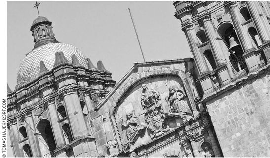
Catedral de Oaxaca architectural details
THE TRAGIC STORY OF PRINCESS DONAJI
The fabled marriage of King Cosijoeza (koh-see-hoh-AY-zah) of the Zapotecs to Coyollicatzin (koh-yoh-yee-KAH-tseen), daughter of Emperor Moctezuma II of the Aztecs, around 1490, was a happy one. It resulted in five children, the youngest of whom was a charming little girl.
The king asked his soothsayers what their divinations told of his little daughter’s future. They replied that her life would be filled with tragic events and that she would finally sacrifice herself for her people. The king, saddened by the news but happy that she would turn out to be so selfless, named her Donaji (Great Soul).
Earlier, Cosijoeza, who ruled the Zapotec Isthmus domains from his capital at present-day Tehuántepec, had been an uneasy ally of his old enemy, King Dzahuindanda (zah-ween-DAHN-dah) of the Mixtecs. In 1520, with the Aztec threat diminished by the Spanish invasion, Cosijoeza recklessly attacked the fierce Mixtecs, losing the initial battle and then nearly his life as the Mixtecs pressed their advantage.
However, the Spanish, in the person of Hernán Cortés’s lieutenant, Francisco Orozco, soon imposed a Mixtec-Zapotec treaty in which Dzahuindanda received Princess Donaji as a hostage to guarantee the peace.
Having Donaji as a prisoner at Monte Albán (known as Danni Dipaa in those days) was not exactly an advantage to Dzahuindanda, for he suspected that she was as much a spy as a hostage. His guess was right. Donaji gleaned intelligence vital to the Zapotec counterattack her father Cosijoeza was planning. At the moment Dzahuindanda’s forces were most vulnerable, she sent her father a secret message to attack, which he did, with complete success, except for one thing.
With the treaty broken, the outraged Mixtecs decided to do away with Donaji. They decapitated her and buried her body before her father could rescue her. Later, some Zapotecs found Donaji’s remains on the bank of the Atoyac river. They were surprised to see a lovely violet wild iris blossoming from her blood. Even more surprising, they found the flower’s roots growing around her head, which was without any sign of decomposition.
Three hundred years later, the Oaxaca government decided to honor the heroine who sacrificed herself for her people by adding an image of Donaji’s head to the Oaxacan coat of arms, where it remains to the present day.

Princess Donaji sacrificed her life in order to protect the safety of her Zapotec kinfolk.