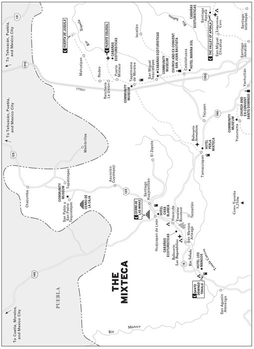
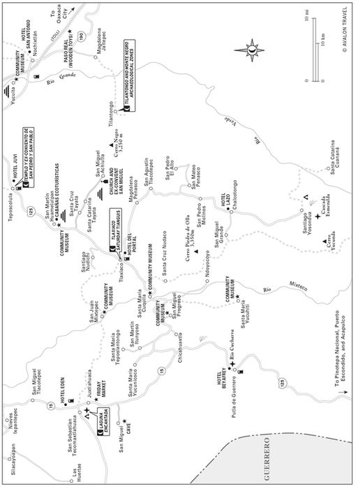
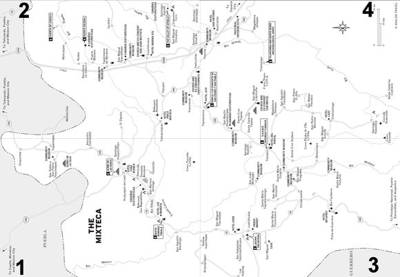
THE MIXTECA

The homeland of the Mixtecs, Oaxaca’s “People of the Clouds,” spreads over an immense domain encompassing the state’s entire northwest, stretching northward from the tropical Pacific coast over the high, cool pine-tufted Sierra to the warm, dry “Land of the Sun” along Oaxaca’s northern border. The Mixteca’s vastness and diversity have led Oaxacans to visualize it as three distinct sub-regions: Mixteca Alta, Mixteca Baja, and Mixteca de la Costa. These labels reflect the geographical realities of the Mixteca’s alta (high) and baja (low) mountains and the tropical Pacific costa (coastal plain and foothills).
The Mixteca Alta comprises the Mixteca’s highest, coolest country—all or part of the governmental districts of Nochixtlán, Coixtlahuaca, Teposcolula, and Tlaxiaco. The Mixteca Baja includes, on the other hand, the warm, dry districts of Huajuapan, Silacayoapan, and parts of Juxtlahuaca along Oaxaca’s northern frontier. The Mixteca de la Costa lies south of all this, encompassing the tropical coastal districts of Putla and Jamiltepec on Oaxaca’s southwest border.
This chapter traces a counterclockwise circle route through the Mixteca, northwest from Oaxaca City. First, we arrive in Nochixtlán, scarcely an hour from Oaxaca City, and use it as a base for exploring the hidden delights of the southern Mixteca Alta. Next, the route continues north through country renowned for its exquisite and monumental Dominican churches, then on to the warm, sunny Mixteca Baja country around Huajuapan de León. There, our journey curves through the scenic back door to the Mixteca Alta—the cool, verdant roof of Oaxaca.
HIGHLIGHTS
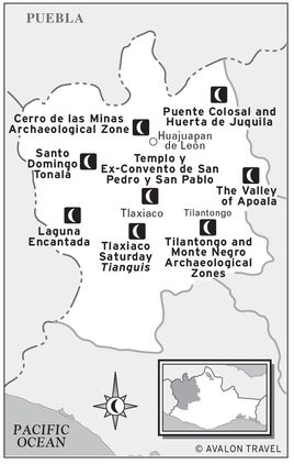
 Tilantongo and Monte Negro Archaeological Zones: The ancient capital of the Mixteca and nearby Monte Negro, with ruins dating back to 500 B.C., make a memorable one-day excursion (
 Tilantongo and Monte Negro Archaeological Zones).
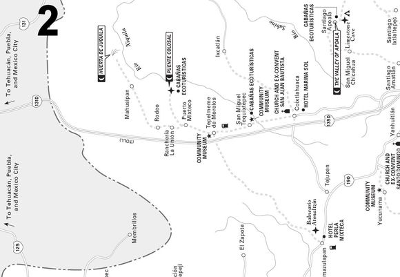
 The Valley of Apoala: This bucolic, spring-fed, mountain-rimmed Oaxacan Shangri-La, replete with scenery and legends, deserves at least an overnight (
 THE VALLEY OF APOALA).
 Templo y Ex-Convento de San Pedro y San Pablo: The newly restored gargantuan Capilla Abierta (Open Chapel), big enough for 10,000 acolytes, crowned the Dominican padres architectural efforts in Oaxaca (
 Templo y Ex-Convento de San Pedro y San Pablo).
 Puente Colosal and Huerta de Juquila: Scramble a mile downhill into a hidden box canyon and explore one of the world’s tallest natural bridges, decorated by giant, yet-to-be-deciphered Mixtec petroglyphs (
 Puente Colosal and Huerta de Juquila).
 Cerro de las Minas Archaeological Zone: A high point of your Mixteca visit will most likely be the chance to climb to the top of the regal pyramids and stroll the broad stately plazas of this archaeological zone (
 Cerro de las Minas Archaeological Zone).
 Santo Domingo Tonalá: This village is worth a visit, both for the 16th-century Templo de Santo Domingo and the lovely cypress grove behind it (
 Santo Domingo Tonalá).
 Laguna Encantada: This legendary spring-fed lagoon is deep, cold, and crystal-clear emerald green. It’s set at the foot of a towering mountain with picture-perfect gnarled ahuehuete cypresses inhabiting its banks (
 Laguna Encantada).
 Tlaxiaco Saturday Tianguis: This native market, with its winding, awning-draped stalls of scarlet tomatoes, deep green cucumbers, bright yellow calabazas (gourds), lilies, roses, and marigolds, may be Oaxaca’s most colorful (
 Tlaxiaco Saturday Tianguis).
LOOK FOR  TO FIND RECOMMENDED SIGHTS, ACTIVITIES, DINING, AND LODGING.
PLANNING YOUR TIME
The Mixteca is a large and fascinating region, rich in history and natural wonders, quickly accessible by tour, bus, or car from Oaxaca City. Your interests, of course, will show you how to use your time. If you have only a day, you can get a quick glimpse of the Mixteca on a day trip, visiting the grand restored 16th-century Dominican churches at Yanhuitlán and Teposcolula and returning to Oaxaca City in the afternoon. If you add a day for a Friday overnight in Tlaxiaco, you could soak in the sights and sounds of the big, colorful Tlaxiaco Saturday tianguis (native town market) before returning back to Oaxaca City.
Add two days to the above and you’ll have time en route to Yanhuitlán for a rewarding two-day side-trip from Nochixtlán for a hotel or camping overnight in the lovely, rustic Valley of Apoala. Here you can soak in Apoala’s tranquil, bucolic ambience while exploring the limestone Cave of the Serpent, the towering canyon of the Two Colossal Rocks, and the Tail of the Serpent waterfall.
With a week to spend, you could enjoy a grand circle tour of the Mixteca. It would be best to synchronize your trip with the vibrant markets (Fri. in Juxtlahuaca, Sat. in Tlaxiaco) along the way. You can do this by heading north from Oaxaca City on Monday, over-nighting in Apoala, then continuing northeast for an overnight or two in Huajuapan, capital of the Land of the Sun, in the Mixteca Baja. Here you’ll find a charmingly refined city around a lovely central plaza, dotted with comfortable hotels and good restaurants. The town’s sights could begin with the market and continue to the monumental pyramids of the Cerro de las Minas Archaeological Zone north of town. A rewarding day trip out of Huajuapan would include the lovely green Valley of the Río Mixteco and a visit to the pilgrimage town of San Pablo and San Pedro Tequixtepec and its community museum that highlights the fascinating, but as yet untranslated, Ñuiñe glyphs.
On Thursday, continue your tour by heading south to Santo Domingo Tonalá for a visit to the town’s great grove of ancient sabino trees and a walk into the nearby Boqueron (Big Mouth) of the spectacular canyon of the Río Mixteco. Continue south for an overnight at Juxtlahuaca; on Friday, stroll the fascinatingly rich native market and marvel at the emerald-green Laguna Encantada spring-fed lake. Spend the night in Tlaxiaco, and on Saturday take in the grand market, the cathedral, and the unmissable Botica la Parroquia antique pharmacy.
On Sunday, return back to Oaxaca City, with stops in Teposcolula and Yanhuitlán.
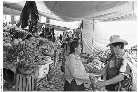
the Saturday tianguis (market) at Tlaxiaco
Northwest from Oaxaca City
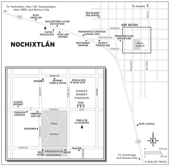
NOCHIXTLÁN
Nochixtlán (noh-chees-TLAN, pop. 11,000), busy capital of the governmental district of Nochixtlán, is interesting for its colorful market and festivals and especially as a jumping-off point for exploring the wonders of the idyllic mountain valley of Apoala and the remains of the ancient Mixtec kingdoms of Tilantongo and Yucuita.
Sights
Nochixtlán town itself spreads out from its plaza, which is directly accessible from Highway 190, from the Oaxaca side by north–south street Calle Progreso and, from the adjacent, Tamazulapan side, by east–west Calle Porfirio Díaz. The streets intersect at the northwest corner of the central plaza. From there, you can admire the distinguished 19th-century twin-towered Templo de La Asunción rising on the plaza’s opposite side. Adjacent, to the right of the church, the presidencia municipal spreads for a block along Calle Hidalgo. At the plaza’s northeast side is the big market, which expands into a much larger tianguis on Sunday, when campesinos from all over northwest Oaxaca crowd in to peruse, haggle, and choose from a small mountain of merchandise.
The major patronal fiesta, celebrating Santa María de La Asunción, customarily runs August 1–21, climaxing around August 15. Merrymaking includes calendas (religious processions), marmotas (giant dancing effigies), mascaritas (dancing men dressed as women), nearly continuous fireworks, a blaringly loud public dance, and a carnival of food, games, and rides that brightens the entire central plaza.
Accommodations
The town’s three recommendable hotels are all on Highway 190, which curves past the edge of town.
For room for parking and a green inner patio, check out the loosely run but family-friendly Hotel Santillan (Porfirio Díaz 88, tel./fax 951/522-0351, norbertpcl@hotmail.com, $20 s or d, $27 d in two beds, $29 t), on the highway’s west (Tamazulapan) side, convenient for drivers and RVers. The motel-style rooms are arranged in an L-shaped, two-story tier around a spacious inner parking lot, with kiddie pool and patio garden. Additional amenities include a volleyball/basketball court and a pair of shady picnic palapas. Upper rooms, probably the best choice, are plainly furnished, but light. All come with hot-water shower-baths, parking, and a family-run restaurant, as well as proximity (half a block west) to the Omnibus Cristóbal Colón–Sur bus station. (Details, however, are not the family’s strong point. Inspect your room to see if all is in order and repaired before moving in.)
Right across from the main bus station, check out the brand-new Hotel San Antonio (Porfirio Díaz 112, no phone, $20–40 s or d). The 25 semi-deluxe rooms, invitingly furnished in beige-tone bedspreads and drapes, with shiny hot-water bathrooms and spacious modern-standard wash basins and commodes, are stacked in three stories above the bottom-floor parking garage. More expensive rooms come with king-size beds and whirlpool tubs.
On the diagonally opposite, Oaxaca, side of town, find the newish Hotel Juquila (Hwy. 190, Km 1, tel. 951/522-0581, $26 s or d in one bed, $32 d or t in two beds) on the highway, about 0.8 kilometers (0.5 mi) from the center of town, a few doors from the ADO bus stop. The hotel’s name comes from the owner’s devotion to the Virgin of Juquila, for whom he keeps a candle burning in front of a picture of the Virgin on the hotel front desk. Upstairs, the rooms are sparely decorated but very clean. Many are dark, however. Ask for one with mas luz (more light). Rooms all come with TV, hot-water showers, and a restaurant downstairs. If you’re sensitive to noise, come prepared with ear plugs; the passing trucks and buses may be a problem here.
Food
Nochixtlán offers a sprinkling of budget meal and bakery options. For wholesome (if they’re hot) country-style meals, go to the fondas (food stalls) in the market, on the north side of the plaza.
In the evenings the action spreads to the market streetfront, across from the church, where a line-up of stalls does big business serving a small mountain of tacos, tortas, quesadillas, and especially the Oaxaca specialty, tlayudas: giant pizza-sized crisp tortillas loaded with everything from beans and cheese to spicy chorizo sausage, cabbage, boiled eggs, and more ($3–6).
Freshly baked offerings are plentiful at Panadería Plaza (Porfirio Díaz, no phone, 7 A.M.–9:30 P.M. daily), a block and a half west of the plaza.
Nochixtlán’s restaurant of choice is Dos Agaves (local cell tel. 044-951/160-4399, 8 A.M.–8 P.M.daily, comida corrida $2.50). Although breakfast is fine here, they specialize in hearty four-course comidas corrida (set lunch; for example, fresh strawberry punch, rice, cream of carrot soup, and scrumptious meat balls in sauce). Find them on the west side of downtown. From the highway, walk east along Porfirio Díaz a block, turn left and go one block to Morelos and continue a fraction, to Dos Agaves (which looks like a rustic cowboy bunkhouse) on the left.
Alternatively, try Restaurant Uruapan (southwest corner of Porfirio Díaz and Hwy. 190, tel. 951/522-0495, 8 A.M.–9:30 P.M. daily, $3–5). Offerings include especially good Mexican-style breakfasts with fruit; a hearty afternoon four-course comida with tasty entrées, such as guisado de res (savory beef stew), and soup, rice, and dessert included; and à la carte omelets, tacos, quesadillas, tamales, and much more for supper.
Information and Services
Find the correo (tel. 951/522-0309, 8 A.M.–4:30 P.M. Mon.–Fri., 8 A.M.–noon Sat.) at the plaza’s southwest corner, west end of the presidencia municipal. Skip uphill east, half a block past the presidencia municipal, to telecomunicaciones (corner of Hidalgo and Reforma, tel. 951/522-0053, 9 A.M.–3 P.M. Mon.–Fri.).
For economical local or long-distance telephone access, buy a widely available Ladatel telephone card and use it in one of the several downtown street telephones. Otherwise, use the long-distance public phone and also connect to the Internet, at Claudia’s restaurant (Porfirio Díaz, tel. 951/522-0190, 9 A.M.–11 P.M. daily). Find it on the north side of Porfirio Díaz, a block west of the plaza.
Stock up with pesos at Bancomer (tel. 951/522-0154, 8:30 A.M.–4 P.M. Mon.–Fri.), in the middle of the plaza’s west side, with a 24-hour ATM.
A number of attractive all-Oaxaca handicrafts are for sale at the small Tradición Santiago (Porfirio Díaz 49, tel. 951/522-0294, 9 A.M.–9 P.M. daily). Offerings include fetching embroidered huipiles from remote source villages (such as Yalalag and Tehuacán), genuine homegrown Oaxaca mescal, and the famous green pottery from Atzompa.
Furthermore, beside the toll expressway between Nochixtlán at Km 209, about 16 kilometers (10 mi) past the Huitzo toll gate, watch for the bright toys beside the road. A close look reveals a charming treasury of handmade wooden toys, from windmills and angels to trucks and tractors. They’re made by the local members of Paso Real Toy cooperative (8 A.M.–8 P.M., toys $2–10).
Simple over-the-counter remedies and prescriptions are available at the big well-stocked drugstore, Farmacia San Luis (tel. 951/522-0484, 7 A.M.–11:30 P.M. daily) at the plaza’s northwest corner.
As for doctors, you can visit the Centro de Especialidades (Melchor Ocampo 10, tel. 951/522-0594, 9 A.M.–7 P.M. Mon.–Sat.) of José Manuel Sosa Bolanos, M.D.
For police and fire emergencies, dial tel. 951/522-0430, or go to the policía municipal, at their plaza-front station, at the east end (across from the church) of the presidencia municipal.
Getting There and Away
Several long-distance bus lines serve Nochixtlán. Luxury and first-class Autobuses del Oriente (ADO), first-class Omnibus Cristóbal Colón (OCC), and second-class Sur (operating jointly out of their west-side station on Porfirio Díaz, Hwy. 190, tel. 951/522-0387) provide broad service southeast with Oaxaca City; northwest both along Highway 190, with the Mixteca Baja (Tamazulapan, Coixtlahuaca, Huajuapan), and along the autopista 135D, continuing to Puebla, Veracruz, and Mexico City Tapo and Tasqueña terminals; and west with Teposcolula, Tlaxiaco, Juxtlahuaca, Putla, and intermediate points in the Mixteca Alta.
Additionally, second-class Fletes y Pasajes (Porfirio Díaz, corner of Hwy. 190, tel. 951/522-0585) offers connections northwest with Mexico City via Tehuacán and Puebla and southeast, with Oaxaca.
Enterprising Transportes Turísticos de Nochixtlán (Porfirio Díaz 72, tel. 951/522-0503, 6 A.M.–9 P.M. daily, $15), on the west-side highway, offers fast and frequent Suburban van rides to and from Oaxaca City. In Oaxaca City, contact them downtown (Galeana 222, tel. 951/514-0525). They also rent Suburban station wagons for $15 per hour; negotiate for a cheaper daily rate. This would be especially handy for a family or group visit to Apoala. Drivers can cover the 80 kilometers (50 mi) from Oaxaca City in an easy hour via the cuota autopista. If you want to save the approximately $6 car toll (more for big RVs and trailers), figure about two hours via the winding old Highway 190 libre (free) route.
YUCUITA, TILANTONGO, AND MONTE NEGRO: FORGOTTEN KINGDOMS
Yucuita
Yucuita (pop. 500) was once far more important than it is today. It started as a village around 1400 B.C., then grew into a town of 3,000 inhabitants around 200 B.C., about the same time that early Monte Albán was flourishing. Later, by A.D. 200, it lost population and became a center secondary to Yucuñudahui, several miles north.
The claim to fame of drowsy, present-day Yucuita, about eight kilometers (five mi) northwest of Nochixtlán, is that it sits atop the old Yucuita, one of the Mixteca’s largest and most important (but barely explored) archaeological zones. City officials received donations of so many artifacts that they had to organize a small community museum to hold them. Local volunteers offer, when possible, to open it up for any interested visitor. (Drop by the presidencia municipal before noon, preferably on a weekday, early enough to arrange a visit.)
Inside, your guide might point out (in Spanish) interesting aspects of the collection (mostly pottery): 2,000-year-old turkey eggs; human-effigy censers and bowls; 1,000-year-old manos and metates (stone rollers and grind stones), just like those used today; and a platoon of small, toy-like figurines. The most intriguing piece in the museum is a carved stone relief of a seated figure, appearing Olmec-influenced, holding what looks like a bunch of flowers. Maybe this is related to the meaning of Yucuita, which in Mixtec means Hill of Flowers.
Perhaps your guide will have time to show you around town. In any case, be sure to explore the Yucuita archaeological zone by climbing the reconstructed steps (fast becoming part of the ruins themselves) next to the paved through-town highway, about a 1.6 kilometers (one mi) south of the town plaza. If you’re agile and adventurous, you can enter the site via a dry tunnel that runs about 30 meters (100 ft) from the entrance steps to a big opening and then continues another 30 meters to a final opening, where you can lift yourself out. (Warning: Carry a flashlight and a stick to spot and ward off pests, such as scorpions and rattlesnakes, in time to back out. If this scares you, don’t try the tunnel.)
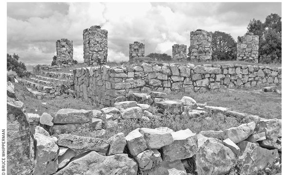
Regal, columned palace-houses speak of Monte Negro’s distinguished past as a commercial and ceremonial center.
Aboveground, what you mostly see is an expansive corn and bean field littered with the stones from the walls and foundations of ancient Yucuita. Pottery shards are common—the colored ones especially stand out. A couple hundred feet to the south of the tunnel opening, inspect the partly reconstructed temple mound with an unfinished stairway and four belowground chambers. Archaeologists say that the entire site, elongated along a north–south axis, is riddled with buried structures, whose remains extend beyond the high hill (the original Hill of Flowers) to the north.
If possible, coordinate your Yucuita visit with the Fiesta de San Juan Bautista (June 22–24), when the ordinarily sleepy town is at its exciting best. Many folks return home to Yucuita from all over Mexico and the United States for reunions and to once again enjoy country delicacies, dance the favorite old dances, honor San Juan with grand floral processions, and thrill to rockets bursting and showering stars overhead. (If you can’t come in June, then come for the equally popular fiesta to honor the beloved Virgin of Guadalupe around December 18.)
GETTING THERE
Reach Yucuita via minibus from Calle Porfirio Díaz, in front of the Nochixtlán market, or along Highway 190, northwest side of town. Drivers: Head northwest on Highway 190 from Nochixtlán. Continue straight ahead along the old Highway 190, Huajuapan direction (not the cuota expressway to Puebla and Mexico City). Pass the gas station and continue for about three kilometers (two mi) until you see a signed right turnoff to Yucuita. Southbound drivers: On old Highway 190, watch for the signed left turnoff to Yucuita before Nochixtlán. If you reach the Pemex gasolinera, before the cuota expressway, you have gone too far. Turn around and look for the signed Yucuita right turnoff.
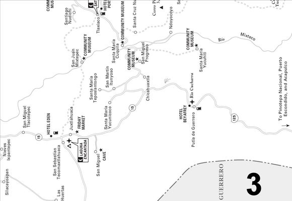
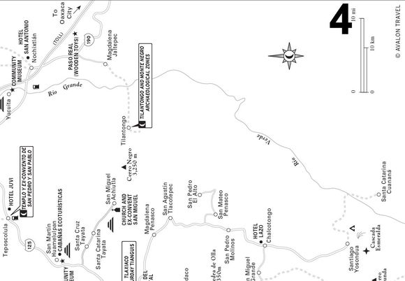
 Tilantongo and Monte Negro Archaeological Zones
The Tilantongo archaeological zone is the town itself (pop. 4,000), which sits smack on top of storied ancient Tilantongo. In the old days, around A.D. 1050, Tilantongo was the virtual capital of the Mixteca, ruled by the ruthless but renowned Mixtec king 8-Deer of the Tiger Claws. Carved stones built into the Tilantongo town church wall attest to Tilantongo’s former glory.
The town government commissioned a mural, now on the outside wall of the presidencia municipal, which dramatically portrays the legendary Mixtec Flechador del Sol (Bowman of the Sun) and copies of pages from the Codex Nuttall, a pre-conquest document in blazing color that records glorious events in Mixtec pre-conquest history. See if you can identify 8-Deer (hint: look for the very pictorial 8-Deer hieroglyph) on one of the Codex Nuttall pages reproduced in the mural.
At least as important and more rewarding to explore is the much older Monte Negro archaeological zone atop the towering, oak-studded Monte Negro (Black Mountain), visible high above Tilantongo. A graveled road, passable by ordinary cars, easier for high-clearance trucks or jeep-like vehicles, allows access to the top in about an hour. If you have no wheels, you may be able to get a taxi driver to take you up there. If not, perhaps someone with a car might accept the job. Fit hikers should allow about three hours for the eight-kilometer (five mi) uphill climb, two hours for lunch and exploring the site, and two hours for the return. Take plenty of water, wear a hat and strong shoes, and use a strong sunscreen. You must obtain permission from authorities at the presidencia municipal (tel. 951/510-4970), who require that a local guide (whom they will furnish, fee about $10, plus lunch) accompany you.
Monte Negro flourished about the same time as early Monte Albán, 500–0 B.C. The 150-acre hilltop zone is replete with ruined columned temples, raised residences of the elite (complete with inner patios), ceremonial plazas, and a ball court, all aligned along a single avenue. Monte Negro’s long, north–south orientation is reminiscent of Monte Albán, although its structures are not as grand. For reasons unknown, Monte Negro, like Monte Albán, was abandoned during the Late Urban Stage, around A.D. 800. All that remains are the old city’s stone remnants, while its descendants still husband the land you see in all directions from the breezy hilltop. Some of what surrounds you is thick oak forest; other parts are fertile terraced corn and bean fields; while much, in mute testimony to the passage of time, is tragically eroded.
GETTING THERE
Bus passengers can go by the Tilantongo–Nochixtlán bus, which makes the trip about three times a day from Calle Porfirio Díaz, in front of the Nochixtlán market. Drivers: Follow Highway 190 (old libre route) to the Jaltepec paved turnoff about 13 kilometers (eight mi) southeast (Oaxaca City direction) from Nochixtlán. Mark your odometer at the turnoff. The road is paved to the Jaltepec plaza (8.2 km/5.1 mi), where you turn right. The road is dirt and gravel, often rough, after that. Follow the Tilantongo (or Teozocoalco) signs. Turn left at a church (17.7 km/10.8 mi) at Morelos villages, and right after a river bridge (23.8 km/14.8 mi). (Note: The riverfront at the bridge would make a lovely picnic or overnight camping spot, beneath the shade of the grand old sabino, especially during the dry, clear-water fall–spring–summer season.) You’ll pull up to the Tilantongo plaza after 29 kilometers (18 mi) and about an hour of steady, bumpy driving.
 THE VALLEY OF APOALA
It’s hard to describe the valley of Apoala, tucked in the mountains north of Nochixtlán, with anything less than superlatives. A fertile, terraced, green vale nestles beneath towering cliffs far from the noise, smoke, and clutter of city life. Apoala is no less than a Oaxacan Shangri-La—a farming community replete with charming country sights and sounds, such as log-cabin houses, men plowing the field with oxen, women sitting and chatting as they weave palm-leaf sombreros, dogs barking, and burros braying faintly in the warm dusk. The spring-fed river assures good crops; people, consequently, are relatively well-off and content to remain on the land. They have few cars, almost no TVs, and few, if any, telephones.
What’s more, the local folks are ready for visitors. I arrived at a string stretched curiously across the narrow gravel entrance road. I realized that there must be a good reason for this, so I stopped, instead of just barging in. The explanation is that the local folks want to tell you about the wonders of their sylvan valley. The entrance fee is about $5 per group, which includes a guide (an absolute must).
Exploring Apoala
The tour, which takes about two hours, begins at the Cave of Serpent, translated from the local Mixtec dialect, which all townsfolk speak. Just before the cave, you pass a crystalline spring welling up from the base of a towering cliff. This spring supplies a large part of the Río Apoala flow, which ripples and meanders down the valley and which folks use to keep their fields green. Another major (and more constant) part of its flow wells up from beneath a huge rock across the creek, below the cave entrance.
Entering the cave, be careful not to bump your head as you descend the tight, downhill entrance hollow. Immediately, you see why your guide is so important: He carries a large battery and light to illuminate the way. In the first of the cave’s two galleries, bats flutter overhead as your guide reveals various stalactites and then flashes on the subterranean river gurgling from an underground dark lagoon, unknown in extent. What is known, however, is that the water from the lagoon arrives at the springs at Tamazulapan, more than 50 kilometers (30 mi) away. Someone long ago dropped some oranges into the cave lagoon in Apoala, and they bobbed to the surface later in Tamazulapan.
See THE LEGEND OF THE FLECHA DEL SOL (ARROW OF THE SUN)
In the other cave gallery (careful, the access is steep and slippery), the light focuses on a towering stalagmite capped by a bishop’s visage, complete with clerical miter and long beard. On the other side, you see a stalactite shaped exactly like a human leg.
After the cave, you’ll head up-valley between a pair of cliffs that tower vertically at least 150 meters (500 ft). If you speak Spanish or have someone to interpret, be sure to ask the guide to explain the names and uses of the plantas medicinales (medicinal plants) along the path. Every plant, even the notorious mala mujer (bad woman), which your guide can point out, seems to have some use.
Soon, above and to your left, you’ll see the towering 600-meter (2,000 ft) burnt-yellow rampart, La Peña Donde Murió El Aguila con Dos Cabezas (The Rock Where the Eagle with Two Heads Died). No kidding. It seems that, once upon a time, a huge eagle that actually had two heads lived in one of the many caves in the rock face. The problem was, it was killing too many lambs, so one day one of the villagers shot it. The Eagle with Two Heads, however, lives on in the community memory of Apoalans.
Finally, after about 20 minutes of walking and wondering at the natural monuments towering around you, the climax arrives: a narrow, river-cut breach in the canyon, like some antediluvian giant had cut a thin slice through a mountain of butter. The slice remains, between a pair of vertical rock walls called Las Dos Peñas Colosales (The Two Colossal Rocks).
The grand finale, down-valley about 1.6 kilometers (one mi), is the waterfall Cola del Serpiente (The Serpent’s Tail). You walk down a steep forested trail that looks out on a gorgeous mountain and valley panorama. At the bottom, the Río Apoala, having already tumbled hundreds of feet, pauses for spells in several pools, and finally plummets nearly 90 meters (300 ft) in a graceful arc to an emerald green pool surrounded by a misty, natural stone amphitheater.
Local Guides
If you’d like a guide for more local exploring, contact very knowledgeable and personable Leopoldo Guzman Alvarado, who, if he can’t guide you himself, will find someone who can, such as youthful Oswaldo López Jiménez. To contact them in advance, leave a message via the Apoala satellite phone: Dial long distance 01-55/5151-9154.
Accommodations and Food
Camping ($15 per day per group, pay at the cabaña ecoturística), by self-contained RV or tent, would be superb here. The community has set aside a choice grassy riverside spot, across the river from the cave at the upper end of town—heavenly for a few days of camping. Clear, pristine spring water, perfect for drinking, wells up at the foot of the cliff at the road’s end nearby. Wilderness campers can choose among more isolated spots upstream, ripe for wildlife-viewing. (Swimming, however, is only permitted downstream from the village, preferably at the foot of the waterfall. Always swim with a bathing suit on; skinny-dipping is locally disapproved.)
Non-campers shouldn’t miss staying in Apoala’s fine cabaña ecoturística ($15 pp), where you probably first met your guide. This is a model of Oaxaca’s improved second-generation government-built, locally-managed tourist accommodation. Besides three very clean and comfortable modern-standard rooms with either one or two double beds, it features a light, spacious solarium–sitting room–snack café, serving water, beer, and sodas, as well as breakfast, lunch, and early supper.
Guests can also eat their own food there. If you do, bring your own food, since Apoala has only one basic store, the Conasupo (9 A.M.–4 P.M. Mon.–Tues. and Thurs.–Fri.), with groceries only, no fruit or veggies. In an emergency, go to the very modest abarrotes Juana (grocery), behind the cabaña ecoturística, which furnishes basic meals and a few food supplies.
Overnight reservations are strongly recommended. Reserve directly with Apoala through their satellite phone connection (in Mexico long-distance tel. 01-55/5151-9154; in Mexico City, simply dial as a local call, tel. 5151-9154; from the U.S. tel. 011-52-55/5151-9154). Alternatively, you can get information and lodging reservations in Oaxaca City at the government tourism office (703 Av. Juáraz, tel. 951/516-0123, www.aoaxaca.com).
Getting There and Away
Like Shangri-La, Apoala isn’t easy to get to. Colectivo passengers have it easiest. The Apoala community provides an Apoala-marked colectivo ($5), which leaves from Calle 2 de Abril near the corner of Morelos, Nochixtlán (a block north of the plaza’s northeast corner). At this writing, it departs at noon Wednesday–Monday, arriving in Apoala around 3 P.M. It departs Apoala for Nochixtlán on the same days at around 6:30 A.M. Check locally for the Apoala colectivo schedule with stores or bus or truck drivers parked along Calle 2 de Abril. To check in advance, call the Apoala satellite phone number: Dial long distance 01-55/5151-9154. Otherwise, taxis ($18) and passenger trucks ($4–6) make the same trip hourly until about 5 P.M. from the same spot.
For drivers, the 42-kilometer (26 mi) rough dirt and gravel road is a challenge, especially in an ordinary passenger car. The route heads north from downtown Nochixtlán; turn left from Calle Porfirio Díaz (the street that borders the plaza’s north side) at the street just past (east) the market. Follow the road signs all the way.
Trucks, vans, and VW Beetles carry nearly all the traffic to Apoala, although a careful, experienced driver in an ordinary car could usually complete the trip with minimal damage. The ideal vehicle (which I’ve driven three times) would be a high-clearance Jeep-like truck or sport-utility vehicle, with tough tires. Four-wheel-drive, not necessary under dry conditions, is mandatory in rain. Under dry conditions, lighter, maneuverable campers and RVs could make it; large rigs would be marginal at best, because of the narrow, steep, rocky, and winding descent into Apoala Canyon.
Dominican Route South
Of the four missionary orders—Franciscans, Jesuits, Augustinians, and Dominicans—who established an important presence in New Spain, the Dominicans were dominant in Oaxaca. Hernán Cortés had barely begun to resurrect Mexico City from the rubble of old Tenochtitlán when a stream of Dominican padres was heading southeast to Oaxaca. For the next three centuries, until republican reforms forced many of them from Mexico during the late 1800s, the padres earnestly pursued the spiritual thrust of Spain’s two-pronged “God and Gold” mission in the New World. The Dominicans converted, educated, protected, and advocated for Oaxaca’s native peoples, often in conflict with brutal and greedy Spanish soldiers and colonists.
The Dominicans’ legacy remains vibrant to this day. More than 90 percent of Oaxacans consider themselves Catholics, and lovely old Dominican ex-convent/churches decorate the Oaxacan countryside. Some of these outstanding venerable monuments—notably at Yanhuitlán, Teposcolula, Tlaxiaco, and Coixtlahuaca—grace the Mixteca Alta, not far from the modern town of Tamazulapan, making it a natural base for extended exploration of what has become known as Oaxaca’s Dominican route. The Dominican route’s more isolated (but very intriguing) northern section—north and west of Tamazulapan—is usually explored via the autopista that connects with Coixtlahuaca, from Nochixtlán and Oaxaca City.
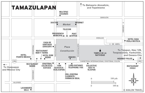
TAMAZULAPAN AND VICINITY
Tamazulapan (tah-mah-soo-LAH-pahn, pop. 5,000), partly by virtue of its crossroads position on the National Highway 190, has eclipsed its more venerable, but isolated, neighbor towns and become the major service and business center for the Teposcolula district. You know you’re in Tamazulapan immediately as you pass its town plaza, which proudly displays a semicircular columned monument right by the highway in honor of Benito Juárez, “Benemérito de las Américas.” Upon reflection, nothing seems more appropriate directly on the Pan-American Highway.
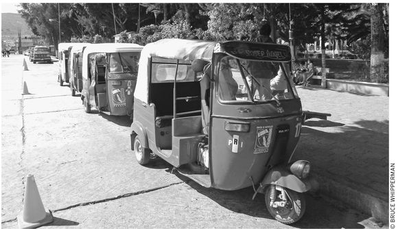
Moto-taxis wait for customers in Tamazulapan.
Sights
As you stand on the edge of the highway (locally known as Carretera Cristóbal Colón) looking at the Benito Juárez monument, you’ll be facing approximately north. The noble, portaled presidencia municipal will appear straight ahead behind the square, the Plaza Constitución. To your right, beyond the storefronts along plaza-front Calle Independencia, rise the ruddy cupolas of the 18th-century Dominican Templo de la Natividad. Bordering the plaza on your left are the stores and services along Calle Constitución.
Walk a block east and step into the cool calm of the venerable Dominican church which, although large and harmoniously decorated, is not architecturally comparable to the masterpieces at Coixtlahuaca, Yanhuitlán, and Teposcolula. What is unique, however, are the two images on the altar, both illuminated. The bottom figure (in the coffin) is an unusually small image of Jesus on the cross. This figure (known as the Señor Tres de Mayo), is locally paraded and celebrated, along with food, games, dancing, and a basketball tournament, in a festival culminating on May 3, El Día de la Cruz.
Above the figure of Jesus is the larger, but still petite town patron, La Virgen de la Natividad (The Virgin of the Nativity), dressed in blue and white, whom townsfolk celebrate in a fiesta culminating on September 8. As you retrace your steps, exiting through the church garden, you pass the old Dominican convent on the left, now mostly converted to storefronts facing the highway.
Tamazulapan townsfolk love their resort, Balneario Atonaltzin (9 A.M.–6 P.M. daily, adults $3, kids $2). You’ll see why if you drive, taxi, or walk the 2.5 kilometers (1.5 mi) north along the road to Tepelmeme (east plaza-front Calle Independencia). Soon after a bridge, you’ll see the balneario (resort) on the right. This spot would be a merely typical Sunday family bathing resort if it were not for its crystalline, naturally disinfected sulfurous springs. The waters gurgle up, cool and clear, from a pair of sources in the rocky cliff behind the Olympian double-size pool—a lap swimmer’s delight (except on Sundays and holidays, when it’s filled with frolicking families). Besides the big main pool, there are two kiddie pools, a local-style restaurant, volleyball, dressing areas, a few picnic tables, and campsites. The balneario invites overnight tent-camping and self-contained RV parking, for about $10 per car, including the general admission fee.
Two lesser-known but nevertheless interesting spots are the nearby ojo de agua swimming hole and the Xatachio archaeological zone. The ojo de agua (literally, eye of water), a general term for a natural spring or source of water, is about 90 meters (300 ft) back from the balneario (resort) toward town, on the right, below the creek bridge. Step toward the ruined building on the right and you’ll see the creek cascading into a big blue pool. Before the Balneario Atonaltzin was built, this was a popular swimming hole. Today, the water appears much less than pure, since it’s mostly used by families for washing clothes. Although the steep riverbank near the bridge is nonnegotiable, you can get down to the water via a path to the right around the ruined building, through the brush, up some stone steps, and down again to the creek.
The unexcavated Xatachio archaeological zone (shah-TAH-shioh) is accessible via the dirt side road on the left, just past the Balneario Atonaltzin. You’ll first spot the zone as a brush-covered hill (actually a former ceremonial pyramid) about 0.8 kilometers (0.5 mi) away on the left. Note: Do not try to explore the site on your own. The site lies on communal land, and people are rightly suspicious of possible artifact looters. Go to the presidencia municipal on the plaza and ask for permission (preferably through a local spokesperson, such as the owner or manager of your hotel); offer to pay someone (approximately $15) to act as a guide for a couple of hours. Any artifacts you might stumble upon are legally the joint property of the INAH (National Institute of Archaeology and History) and the local community.
Tejupan
If you have time, stop for a few minutes for a look inside the relatively humble, but nevertheless worthy, Dominican church and ex-convent at Tejupan (Tay-HOO-pahn) in the Tamazulapan valley, a 15-minute drive east (Oaxaca City direction) from Tamazulapan. Tejupan is a sleepy farming town, basking in its past glory, visibly represented by its noble, multi-portaled palacio municipal and the distinguished 17th-century Dominican Templo y Ex-Convento de Santiago Apóstol, across the street. Memorable inside the church is the pretty pink transept chapel, left side, dedicated to the Virgin of Guadalupe. The restored ex-convent section stands to the right of the church front entrance.
Get to Tejupan by bus, taxi, or car via the signed side road off Highway 190 about 11 kilometers (seven mi) southeast of Tamazulapan, or about 13 kilometers (eight mi) northwest of the Highway 190–Highway 125 junction northwest of Yanhuitlán.
Accommodations
Of Tamazulapan’s acceptable hotels, most prominent is the four-story Hotel Dom Pedro (Cristóbal Colón 24, tel./fax 953/533-0736, $14 s or d in one bed, $16 d in two beds, $18 t), a few doors north of the plaza. The 25 plain but clean upstairs rooms (no elevator) come with toilets and hot-water showers, TV, and parking, but no phone except the long-distance phone at the hotel desk. Credit cards are not accepted.
Although Hotel Puerto Mexico (Cristóbal Colón 12, tel. 953/533-0044, $19 s or d, $22 t), a few doors farther west, appears humdrum from the outside, guests enjoy an inviting tropical patio blooming with leafy banana trees. Rooms are clean and carpeted but have the almost universal Mexican small-town bare bulb hanging from the middle of the ceiling. Bring your own clip-on lampshade. Amenities include hot-water showers, parking, TV, and a pretty fair restaurant downstairs, but no phones. Credit cards are accepted.
The star of Tamazulapan hotels is the deluxe, newish  Hotel Casa Perla Mixteca (Calle 2 de Abril 3, tel./fax 953/533-0280, toll-free Mex. tel. 800/717-3956, $25 s, $28 d, and $33 t). A major plus here is the hotel’s quiet location, removed from the noisy highway truck traffic. Take your pick of 10 designer-decorated rooms, with rustically lovely tile floors, handwoven bedspreads, reading lamps, and shiny bathrooms with hot-water showers.
Food
For inexpensive prepared food, try the fondas (food stalls) inside the market and the nighttime taco stands or one of the several sit-down snack bars along the highway by the plaza.
As for restaurants, although the Hotel Puerto Mexico offers breakfast, lunch, and dinner, you might do better by walking a few steps west to  Restaurant Noemi (Cristóbal Colón 16, tel. 953/533-0595, 8 A.M.–11 P.M. daily, $2–7) between Hotel Puerto Mexico and Hotel Dom Pedro. The grandmotherly owner puts out Mexican home-style breakfasts, lunches, and suppers, including savory café de la olla (pot-brewed coffee, with cinnamon).
Another good choice is Restaurant Mar y Tierra (Cristóbal Colón 20, tel. 953/533-0045, 8 A.M.–10 P.M. daily, $4–12), between Hotel Dom Pedro and Restaurant Noemi. In a relaxingly airy patio location, patrons select from a long menu of breakfasts, soups, salads, pastas, seafood, and meat and suppers of Mexican specialties. They also serve a selection of good beers and wines from their bar.
Alternatively, check out the clean, highway-front Restaurant Coqui (KOH-kee; Cristóbal Colón 57, tel. 953/533-0109, 7 A.M.–9 P.M. daily), a block and a half east from the plaza. Although she’ll cook nearly anything you want, the hard-working owner is best at Oaxacan country delicacies, such as chiles rellenos, enchiladas tasajos (beef enchiladas), and Oaxacan tamales, covered with plenty of mole negro. (At this writing, however, her asking breakfast prices for scrambled eggs, fruit salad, ordinary coffee, and orange juice have doubled.)
Shopping
Get groceries, fruit, and vegetables at either the town market behind the presidencia, or at one of the plaza-front abarroterías (grocery stores), such as west plaza-front Casa de Santiago (Constitucion 6, tel. 953/533-0015, 8:30 A.M.–3:30 P.M. and 4:30–9:30 P.M. daily).
The market, especially during the big Wednesday tianguis, can be a good spot for local indigenous handicrafts shopping. Items might include pottery and palm-leaf woven goods such as tenates (tump-line baskets), petates (mats), and soft woven Panama hat–like sombreros.
Services
Tamazulapan provides a number of basic services along the blocks near the plaza. At this writing, there is neither bank nor ATM, so make sure to arrive with a supply of pesos (from banks in Nochixtlán, Tlaxiaco, or Huajuapan) or U.S. dollars that you may be able to exchange in local stores or at your hotel.
For public telephone, money orders, and fax, find the telecomunicaciones (a block north along Independencia, at corner of Obregón, tel. 953/533-0113, 9 A.M.–3:30 P.M. Mon.–Fri., 9 A.M.–1 P.M. Sat.) behind the presidencia. For stamps and sending mail, walk a few doors farther west along Obregón to the correo (Obregón, 8 A.M.–4:30 P.M. Mon.–Fri., 9 A.M.–1 P.M. Sat.). Half a block farther along Obregón, you can send a fast, secure mailing via courier service Multipac (Obregón 2, 9 A.M.–3 P.M. Mon.–Fri., 9 A.M.–noon Sat.).
For telephone service, go to the larga distancia across the highway from the plaza, or one of the three or four Ladatel card-operated public phones sprinkled along the highway and near the plaza. Answer your email at the Internet store (across from the plaza, tel. 953/5330694, 9 A.M.–11 P.M. daily).
At least two doctors near the plaza offer consultations and medicines. Choose either Dra. Josefina Clemente at her Farmacia Ideal (on the highway directly opposite the plaza, tel. 953/533-0224; pharmacy: 8 A.M.–9 P.M. Mon.–Sat.; consultations: 4–8 P.M. Mon.–Fri.); or Dr. Fidel A. Cruz Ramírez (a block and a half north from the highway, on the west Constitución side of the market; no phone; consultations: 9 A.M.–3 P.M., 5–9 P.M. Mon.–Fri.).
For a police emergency, contact either the Delegación de Transito highway police (half a block east of the plaza, on the same side as the highway, tel. 953/533-0472, on duty 24 hours); or the municipal police (at the presidencia municipal, tel. 953/533-0017).
Get your laundry done at handy Lavandería Delij (on Zaragoza, 9 A.M.–8 P.M. Mon.–Sat.), a block and a half south (uphill) from the Hotel Puerto Mexico on the highway.
Getting There and Away
Bus lines Omnibus Cristóbal Colón and Sur (both across from the plaza, tel. 953/533-0699) operate jointly out of their highway-front station. Their buses connect southeast with Oaxaca City via Nochixtlán; northwest via Huajuapan and Cuautla (Morelos), with Mexico City (Tapo); and south with Teposcolula, Tlaxiaco, and Juxtlahuaca, where you can transfer to a bus headed for Pinotepa Nacional on the Pacific coast.
Good paved roads connect Tamazulapan with all the important Mixteca and Oaxaca destinations: southeast, via Highway 190, 133 kilometers (84 mi), two hours, with Oaxaca City; northwest, 41 kilometers (25 mi), 45 minutes, with Huajuapan; north, by paved (but potholed) secondary road via Tejupan, 35 kilometers (22 mi), 45 minutes, with Coixtlahuaca; and south via Highway 190–Highway 125, 35 kilometers (22 mi), 45 minutes, with Teposcolula.
Frequent (10 per day) Transportes Atolzín vans (cell tel. 044/117-8800) connect southeast with Oaxaca City, and northwest with Huajuapan. Check for departures at their small office across the highway from the plaza’s southwest corner.
Servicios Turísticos Teposcolula vans connect south with Mixteca destinations of Teposcolula and Tlaxiaco, and west with Huajuapan. They stop for passengers on the highway, by the plaza.
TEPOSCOLULA
Although smaller in population than Tamazulapan, Teposcolula (pop. 2,000) continues to outrank it as district capital, a distinction it gained way back in 1740. Its history, however, reaches back much further. When the Spanish arrived in the 1520s, they found well-established Mixtec towns on the hillsides above a beautiful lake-filled valley. They drained the lake for farmland and moved the population down to Teposcolula’s present location. Abiding by common practice, the Spanish kept the Mixtec name, Teposcolula (Place Surrounded by Springs), tacking on the Catholic patronal title San Pedro y San Pablo. This produced a name so long that practically no one refers to the official San Pedro y San Pablo Teposcolula. People, however, still remember the old pre-conquest settlements on the hillsides. The old palace and temple foundations still stand, as El Fortín (The Fort) on the uphill slope behind the town and Pueblo Viejo (Old Town) on the pine-clad hilltop across the valley.
Teposcolula’s central plaza is quiet most of the time.
Orient yourself by standing (or imagining you’re standing) on the sidewalk on the through-town highway, facing the tree-shaded town plaza. North will be straight ahead, toward the cartoon-bright, repainted presidencia municipal on the far side of the plaza. The main streets are 20 de Noviembre (the highway), Madero (along the plaza’s left, west side), and Iturbide (along the plaza’s right, east side). Diagonally on your left stands the renowned Templo y Ex-Convento de San Pedro y San Pablo.
 Templo y Ex-Convento de San Pedro y San Pablo
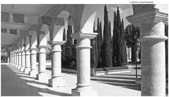
Most visitors head right over to the venerable 1538 Dominican church and ex-convent, one of Oaxaca’s most important, not only for its historical significance, but also for its monumental architecture, much of which you can view from the exterior by walking around to the church’s back (west) side. Here rises the famous, recently-restored Capilla Abierta (Open Chapel), with massive, soaring arches and gigantic buttresses. Visitors often wonder why such a huge outdoor chapel was needed right next to an equally massive indoor church. The adjacent grassy expanse provides the reason. It’s the atrium, the extension of the outdoor chapel, the largest in Mexico, where the Dominican builders imagined 10,000 native faithful (so numerous that they were not allowed inside) gathering for mass. Although their vision was fulfilled for a span of perhaps a generation after the conquest, European diseases decimated the Mixtec population by 1600, leaving the huge expanse, equal to three football fields, forever empty.
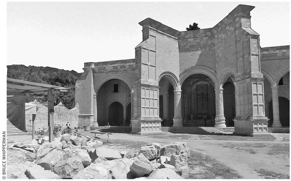
the Capilla Abierta (Open Chapel)
Step into the main church nave, accessible from outside either the nave’s rear door (next to the Capilla Abierta), or from side door on the town plaza. Inside, admire the symphony of glittering retablos (altarpieces) that decorate the walls. The tallest and most magnificent towers above the front altar, where the town patron El Señor de Vidrieras (Lord of the Glass Box) presides. On the right and left of the patron are the grand apostles, respectively: bald St. Peter and pious St. Paul. And, finally, above all the glitter, high over the altar, presides the omnipresent, all-seeing eye of God.
Local people celebrate their Señor de Vidrieras (named for the glass box they parade him in) during a big eight-day festival culminating on the first Friday of Lent (Cuaresma). Events include traffic-stopping processions, pilgrimages, a flower parade, plenty of fireworks, crowning of a queen, floats, bull roping and riding, and a big community dance.
Find the door to the ex-convent (9 A.M.–5 P.M. daily, entrance $2.50) at the rear of the nave. The ex-convent serves largely as a museum of paintings by noted 16th-century artists Andrés de la Concha and Simón Pereyns. As you walk, see if you can recognize the functions—refectory (dining), kitchen, chapel, cloister, monks’ cells (upstairs)—of the various rooms that you pass by or through.
During your visit, at the end of the refectory (monks’ dining hall) be sure to see the fresh, very recognizable modern or restored painting of Jesus with wounds, at the right hand of a very youthful God the Father, with the Holy Spirit (in the form of a radiant dove) above them. In the middle of the refectory, also notice the interesting painting of St. Michael the Archangel dangling a fish. Also, around the cloister, note the paintings that depict the baptism, school days, mission, and dreams of Santo Domingo.
Archaeological Sites and Casa de la Cacica
If you’re interested in historic ruins, you might inquire at the presidencia municipal for a guide to lead you to the El Fortín and Pueblo Viejo archaeological sites. (Note: Don’t try to go to these sites without permission, since local folks are rightly suspicious of strangers poking around their archaeological zones.)
An interesting, close-by site that you can visit without permission is the Casa de la Cacica (kah-SEE-kah, House of the Chiefess). Walk west about three blocks along the street heading due west from the middle of the church’s huge grassy atrium. The street ends at a school, and on the right is the Casa de la Cacica.
The Casa, a complex of buildings, is unique because it’s one of the few known stone structures built by the Spanish specifically for indigenous nobles. The Spaniards’ motivation was probably to concentrate and thus more easily control the local Mixtec population, who were living in dispersed hillside settlements when the Spanish arrived. They built a noble housing complex and evidently persuaded the local cacica (chiefess) to live there, hoping that her people would follow her. Presumably, the House of the Chiefess (under restoration) will eventually become a museum or community cultural center, or both.
Finally, before you leave town, be sure to visit the carcel (jail) at the presidencia municipal on the plaza. There, the prisoners make and sell handicrafts, such as leather belts, leather-covered mescal flasks, and miniature-shoe key rings.
Accommodations and Food
Teposcolula’s first and only hotel (at least in recent times), the Hotel Juvi (tel. 953/518-2064, $13 s, $15 d in one bed, $16 d in two beds, $18 t, $20 q) now makes an overnight stay possible. The hotel’s layout remains unique—12 rooms around a parking courtyard containing the last remnant, a grain storage crib, of the ancient family homestead. Children of the original ancestors have built a sparsely furnished (but clean) lodging, with bare fluorescent bulbs to go with the shiny bathroom fixtures.
You can buy basic food supplies at a plaza-front abarrotes (grocery); a panadería (bakery; on Iturbide, tel. 953/537-8683, 8 A.M.–8 P.M. daily), a block behind the presidencia municipal; or treat yourself to a hearty afternoon comida at the town’s good (but pricey) Restaurant Eunice (tel. 953/518-2017, 8 A.M.–8 P.M. Sun.–Fri., $4–12), a block behind the east side of the presidencia municipal.
Alternatively, go to the modest but clean restaurant Temita (tel. 953/518-2040, 7 A.M.–10 P.M. daily, $3–6), a block east (Oaxaca direction) of the plaza, across from the Cristóbal Colón–Sur bus station.
Information and Services
If you’re sick, consult Dr. Brigido Vidal in his Farmacia Nelly (on the plaza-front east side, a few doors from the highway, tel. 953/518-2072; consultations: 3–10 P.M.; pharmacy: 9 A.M.–2 P.M. and 5–9 P.M. Mon.–Sat.). Alternatively, go to the Centro de Salud (doctor available 8 A.M.–2 P.M. and 4–6 P.M. daily, 24 hours in emergency). Get there via Calle Madero, uphill, passing the presidencia municipal ’s west side. After two blocks, turn left, and continue three long blocks to the centro de salud, on the right.
For police or fire emergencies, contact the police at the presidencia municipal, north side of the plaza.
To mail a letter, make a phone call, or use a fax, go either to the telcomunicaciones (on Madero, upstairs, half a block north of the plaza’s northwest corner, tel. 953/518-2070, 9 A.M.–3 P.M. Mon.–Fri.) or the correo (on Madero, downstairs, 11 A.M.–4 P.M. Thurs. only). Otherwise for telephone, fax, or Internet go the “Mr. Marbo” office (across the highway from the plaza, tel. 953/518-2103, 7 A.M.–10:30 P.M. daily).
Getting There and Away
Bus transportation to and from Teposcolula is easy and frequent. Bus passengers arrive at and depart from the bus station (Autobuses Sur, Omnibus Cristóbal Colón, and Fletes y Pasajes; on Hwy. 125, tel. 953/518-2000), half a block east from the plaza. Buses connect southeast with Oaxaca City; north with Tamazulapan, Huajuapan, and Mexico City; and south with Tlaxiaco, Juxtlahuaca, and Putla (where connections are available with Pinotepa Nacional on the Pacific coast).
Long-distance vans Servicios Turísticos Teposcolula (local cell tel. 044-953/110-9288) connect frequently with Oaxaca and Tlaxiaco, from the small station directly across the highway from the town plaza.
For drivers, Highway 125 runs right past Teposcolula’s town plaza, about 13 kilometers (eight mi) southwest of its junction with the Oaxaca City–Mexico City Highway 190. To or from Oaxaca City, using the cuota autopista (toll expressway), drivers should allow around two hours to safely cover the approximately 125-kilometer (78 mi) Oaxaca City–Teposcolula distance; add at least another hour if going by the old Highway 190 libre (free) route via Yanhuitlán. To or from Tamazulapan in the north, allow about 45 minutes for the 35 kilometers (22 mi) via Highway 190–Highway 125 and about an hour for the 47 kilometers (29 mi) along Highway 125 to or from Tlaxiaco in the south.
YUCUNAMA
Teposcolula’s petite neighbor, Yucunama (pop. 600), is attractive partly because of its small size. Imagine taking a seat on a stone bench one bright, blue summer morning in Yucunama’s flower-decorated town plaza. Birds flit in the bushes and perch, singing, in the trees. Now and then, someone crosses the square and returns your “Buenos días.” You admire the proud, whitewashed bandstand at the plaza center; behind it rises the old church facade, patriotically decorated like a birthday cake in red, white, and green. From the plaza, cobbled streets pass rustic stone houses and continue downhill to verdant fields, which, in the distance, give way to lush oak and pine-tufted woodlands.
Although it sounds too good to be true, it isn’t. Yucunama’s beauty is probably one reason that Mixtec people have been living there for at least 4,000 years. Its name, which means Hill of Soap, perhaps reflects the town’s spic-and-span plaza, clean-swept streets, and newly painted public buildings. It’s a pure Mixtec town, for although Yucunama is part of the Teposcolula district, Spanish settlers never lived here. In fact, in 1585 the all-Mixtec townsfolk declared themselves an independent republic. Nothing came of that, but Yucunama’s people nevertheless retain their independent spirit.
The remarkable must-see Bee Nu’u (House of the People) community museum should be your first stop. The museum now only opens by appointment. Try contacting someone at the dignified, porticoed presidencia municipal, across the plaza from the museum. Say (or show them) this: “¿Puede alguién mostrar el museo para nosotros?” (“Can someone show us the museum?”)
If the presidencia municipal is closed, as it sometimes is, you have the pleasant alternative of knocking on the door of welcoming Señora Cleotilde San Pablo (local cell tel. 044-951 /105-1019, long distance tel. 045-951/105-1019, son Alvaro Emanuel’s email kopec_32@hotmail.com, food $5, lodging $10 pp) who runs the town restaurant Comedor Doña Coti on the north side of the plaza. She promises to find someone who will open the museum for you. Moreover, Cleotilde will also will fix you a meal and put you up in her large, comfortable house overnight. Contact her in Spanish, of course.
All of these preparations are well worth the chance to look inside the excellent, professionally prepared museum. Its several very interesting exhibits include the original of the Lienzo Yucunama, an amate (wild fig bark paper) document from the 1300s that details the 35 tribute payments of a Yucunama Mixtec noblewoman with the name-date 5-Eagle, and her first and second husbands, 12-Flower and 10-Eagle, to her father, who lived in a nearby town. In the cabinet below the lienzo stands a copy of the famous Codex Nuttall (folded like an accordion), which details, in full color, the exploits of the renowned Mixtec lord 8-Deer. Your guide may be able to provide some details (including odysseys to Coatzacoalcos on the Gulf Coast, and perhaps as far as Panama) of 8-Deer’s adventures. If you don’t understand Spanish, the museum is well worth bringing a friend to translate for you.
Another fascinating exhibit displays the complete remains of a robust 70-year-old noblewoman (notice her very husky leg bones) and the trove of goods recovered from her grave, one of a score of burials retrieved locally by archaeologists.
Yucunama’s richness as an archaeological zone is further evidenced by the two 1996 INAH (National Institute of Archaeology and History) survey maps of the buried remains of a pair of early Classic-period (300 B.C.–A.D. 300) towns nearby. If you’re strongly interested, ask at the presidencia municipal and you may be able to get permission and a guide. Expect to pay $20 for a full-day guided trip; transportation is extra.
On the other hand, you can step outside the museum and guide yourself on a short stroll to a pair of nearby local sights. Walk down Calle Independencia (from the museum, follow the left side of the plaza, past the presidencia municipal) about three long blocks east to the picture-perfect town fountain, fed by the old town aqueduct. You may see women doing the day’s laundry in the adjacent arched public washhouse basins. A block south and a couple more blocks downhill east, at the end of Calle Libertad, you can marvel at Yucunama’s oldest resident, the gigantic 1,000-year-old Tule, or ahuehuete tree (Mexican bald cypress, Taxodium mucronatum), a distant cousin of the California redwood. If you get lost, you can identify El Tule by its tall, bushy green silhouette, or mention El Tule (TOO-lay) to anyone.
Festivals
You’ll have even more fun if you arrive during one of Yucunama’s festivals. The biggest is the patronal Fiesta de San Pedro Mártir de Verona, which culminates on April 29. Festivities begin on April 26 with a calenda (procession) and plenty of mescal, aguardiente, and pulque for those so inclined to drink liquor. Sometimes town men dress up like women and perform the dance of the mascaritas (little masks). The fun continues with more processions, plenty of flowers, food, fireworks, masses, and a dance on April 29.
Other especially festive times in Yucunama include the fiesta of the Virgen del Rosario (first Sun. in Oct.), El Día de los Muertos (Day of the Dead, Nov. 1 and 2), and the Christmas Eve procession, where everyone in town accompanies the infant Jesus to the church, then watches (or does) the traditional dance of the Pastor y Pastorela (Shepherd and Shepherdess).
Getting There and Away
Yucunama is about nine kilometers (six mi) northwest of the Highway 125–Highway 190 intersection. Drivers: Follow the signed, graded gravel road that takes off from the north corner of the intersection. By bus: Ride an Omnibus Cristóbal Colón, Sur, or Fletes y Pasajes bus to the Highway 125–Highway 190 intersection, then hike the nine kilometers (six mi) or ride a colectivo van or truck from there. A number of snack stands and small stores at the intersection provide water and food.
YANHUITLÁN
It sometimes seems a miracle that the Dominican padres, against heavy odds and isolated as they were in the far province of Oaxaca, were able to build such masterpieces as their convent and church in Yanhuitlán. Upon reflection, however, their accomplishments seem less miraculous when you realize the mountain of help the padres received. When Father Domingo de la Cruz began the present church, in 1541, Yanhuitlán retained the prosperity and the large skilled population that it had when it was a reigning Mixtec kingdom prior to the arrival of the Spanish. For a workforce, de la Cruz used the labor of thousands of Mixtec workers and artisans, who deserve much of the credit for the masterfully refined monuments that they erected.
And monuments, indeed, they still are. Approaching Yanhuitlán from the northwest, the road reaches a hilltop point where the entire Yanhuitlán Valley spreads far below. In the bright afternoon sun, the white-shining, massively buttressed Yanhuitlán church and adjacent atrium (now soccer field), big enough for 15,000 indigenous faithful, dwarfs everything else in sight.
Up close, you see why. The building’s exquisitely sculptured Renaissance facade towers overhead, making those standing on the front steps appear like ants. A graceful semicircular arch frames the entrance, while in the niche to the left stands the robed St. Francis of Assisi. In the right niche, Santa Margarita de Alacoque occupies the position customarily reserved in Dominican church facades for Santo Domingo de Guzmán. The Dominican order’s revered founder, Santo Domingo de Guzmán, is nevertheless present. Directly above the front portal, a masterful relief of Holy Mother Mary shelters a diminutive Santo Domingo de Guzmán and Santa Catarina de Siena, like small children, beneath her cape.
The church, officially the Templo y Ex-Convento de Santo Domingo de Guzmán, is as much a museum of national treasures as it is a place of worship. In fact, it is divided so: The ex-convent, which you enter on the right, has been converted to a museum (9 A.M.–4 P.M. daily, $4). Inside, you begin to appreciate the gigantic proportions of the place as you circle the cloister, passing beneath ponderous but delicately designed arches that appear to sprout and spread from stone cloister columns like branches from giant trees. On the stairway leading upstairs at the cloister’s corner, don’t miss the mural of Jesus dressed like a 16th-century dandy except for his bare feet and the little angel perched on his shoulder.
The nave glows with golden decorations. Overhead, stone rib arches support the ceiling completely, without the need of columns, creating a single soaring heavenly space. Up front, above the altar, Santo Domingo de Guzmán presides, gazing piously toward heaven, his forehead decorated by a medallion that appears remarkably like a Hindu tilak. Before you exit, take a look by the front door for the dramatic painting of Jesus, whip in hand, driving the money changers from the temple.
Get to Yanhuitlán, on Highway 190, by car, van, or Sur, Fletes y Pasajes, or Omnibus Cristóbal Colón bus. By car, from Nochixtlán, head 12 miles (19 km) north along Highway 190 (62 miles from Oaxaca via the toll expressway, allow an hour and a half), or about 23 miles (37 km) south from Tamazulapan (or about the same from Teposcolula via Hwys. 125 and 190.)
Dominican Route North
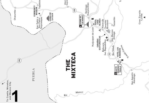
This corner of the Mixteca hides a treasury of undiscovered gems, just right for adventurers hankering to follow the road less traveled. First, make sure you spend some time at the grand old Dominican church at Coixtlahuaca, the Templo y Ex-Convento de San Juan Bautista. Then continue north to the hamlet of San Miguel Tequixtepec to contemplate the ancient (1590) stone bridge and the community museum’s mammoth fossils, then continue on a prehistoric rock painting excursion, and finally enjoy an overnight in San Miguel Tequixtepec’s cozy community-built cabaña lodging. Carry on north to Tepelmeme de Morelos and culminate your adventure by boulder-hopping down into a tropical canyon to the astonishingly grand Puente Colosal.
COIXTLAHUACA
Coixtlahuaca (koh-eeks-tlah-OOAH-kah, pop. 3,000), although the capital of an entire governmental district encompassing a significant fraction of the Mixteca Baja’s municipios, is a modest town even by Oaxaca standards. Before the conquest, it was a powerful Chocho-speaking (Chocholteco) chiefdom, so strong that in the 1400s the Coixtlahuaca warriors stopped the invading Aztecs, forcing them to detour through Tlaxiaco. During colonial times and through the 19th century, Coixtlahuaca continued to be an important Chocholteco market center. But depopulation by emigration and increased education and literacy in Spanish have reduced the number of Chocho speakers to a handful of elderly folks in the surrounding countryside.
Most visitors enter Coixtlahuaca by the cuota autopista from Oaxaca City. Just inside the edge of town, a big sign on the left marks the road north to San Miguel Tequixtepec. Straight ahead a couple more blocks, most drivers turn right on Independencia, the main town street. Nearly all stores and services are spread along Independencia, which continues several blocks past the town plaza and then the church, both above and to the left of the street. Bus passengers will arrive at the Autobuses Sur station, on Independencia, in the town center.
Sights
Coixtlahuaca’s past importance is reflected in its grand church, the Templo y Ex-Convento de San Juan Bautista, one of Oaxaca’s largest. At this writing, it appeared that its grand open chapel, similar to the one at Teposcolula, is being restored. Inside the church’s nave stretches to the proportions of a great European cathedral, its vault soaring overhead, supported by a delicate network of brilliantly painted colored stone arches. Dominican friar Francisco Marín, Coixtlahuaca’s first vicar, was the moving force behind all this grandeur, initiating construction in 1546. Although the Reforms forced closure of the convent in 1856, the Dominicans continued to run it as a church until 1906, when locally based “secular” clergy took over.
In addition to its robust proportions, the church has much of interest. As you enter, notice the dark-complexioned image of African padre San Martín de Porres, in a friar’s robe, on the right. Farther into the nave, gaze overhead and admire the whirling, rainbow-hued floral designs, lovingly executed by long-dead native artists. All are original, although time and recent replastering have erased much that you don’t see. On the right, take a look at the unusually large side altar to the Virgin of Guadalupe and continue to the main altar, where St. John the Baptist, Coixtlahuaca’s patron saint, presides at the foot of the towering, gilded retablo (altarpiece).
The town is mostly quiet, except for fiestas, which include the patronal festival of San Juan Bautista (around June 24) and the festival of the Señor del Calvario (Lord of Calvary), during the last half of May. The fiestas include processions, carnival games, traditional food, the hazardous jaripeo (bull roping and riding), and the Jarabe Chocholteco traditional Coixtlahuaca courtship dance.
Accommodations and Food
The only hotel along the expressway between Nochixtlán and Tehuacán, Puebla, is the local Hotel Marina Sol (Calle Independencia, tel. 953/503-5302, $22). Singles, doubles, and triples are available. Although it has been neglected in recent years, renovations are now complete. The owner’s motivation is most likely the ongoing restoration of the church across the street and the lavish parador turístico (tourist center), recently built nearby (but not yet operating at the time of this writing).
Although the Hotel Marina Sol’s rooms are modestly furnished, they’re clean and spacious, with private hot-water shower-baths. Summer humidity, however, has, in the past, caused the rooms to accumulate mildew. If so, beds will need fresh linens; don’t hesitate to request them before moving in. Guests additionally enjoy a tranquil garden setting, decorated with roses, statuesque Roman cypresses, and a countryside-view deck behind the reception. (You may have to ask around for the manager, who has been present only when guests were expected. If you can’t find the manager, or the rooms are unacceptable, it’s best to lodge at the cabañas in San Miguel Tequixtepec, a few miles north.)
As for food, Coixtlahuaca has two or three local-style comedores and taco shops on Independencia, plus the highly recommended Restaurant Blanquita (on the entrance road from the expressway, tel. 953/504-5420, 9 A.M.–9 P.M. daily, $2–3), downhill, a block below the road north to San Miguel Tequixtepec. Restaurant Blanquita is open for breakfast, including tasty huevos a la Mexicana; lunch, try guisado de res (beef stew) or chilote de pollo (spicy chicken); and supper, such as quesadillas.
Another Coixtlahuaca pleasant surprise is the fruit store, Frutería Juquilita (8 A.M.–8 P.M. daily), on the street above the town plaza and presidencia municipal.
Furthermore, some stores also offer a pair of renowned Coixtlahuaca baked specialties: menudencia rolls—big, brown, and not too sweet, sprinkled with a bit of sesame—and pancake cubes, made with alcoholic pulque instead of water.
Information and Services
Other services along Calle Independencia include a combined farmacia–larga distancia, La Lupita (Independencia, tel. 953/503-5405, 8 A.M.–8 P.M. daily).
At the town plaza, a few blocks east, before the church, next to the plaza-front library, find the telecomunicaciones (9 A.M.–3:30 P.M. Mon.–Fri.) for fax and money orders. Also find a correo (8 A.M.–4 P.M. Tues. only) nearby. Additionally, there is a centro de salud with doctor (8 A.M.–4 P.M. daily), tucked on the side street, between the town plaza and the church grounds.
For handicrafts shoppers, Artesanias del Sur (Independencia 20, tel. 953/503-5475), next to the bus station, offers a fetching collection of locally-crafted pottery, woven palm baskets, sombreros, wooden toys and trinkets, and more.
Getting There and Away
The Coixtlahuaca bus terminal is at the middle of main-street Independencia. Second-class Sur buses connect southeast with Nochixtlán (thence Oaxaca City); south with Tlaxiaco via Teposcolula; and northwest, via the toll expressway, with Tehuacán, Puebla, and Mexico.
A local bus connects Coixtlahuaca, with Highway 190 at Tejupan, accessible by collective taxi either northwest to Tamazulapan, or south, to Teposcolula.
To or from Coixtalahuaca, drivers can also connect with Oaxaca (or Puebla–Mexico City), via the fast and easy cuota autopista (toll expressway); it’s approximately 113 kilometers (70 mi), 80 minutes, to Oaxaca (or Puebla, two hours; Mexico City, four hours in the opposite direction).
Furthermore, drivers to and from Coixtlahuaca can take advantage of the short (24 km/15 mi, 45 minutes) connection with Highway 190 (thence Tamazulapan and Teposcolula) via the paved but sometimes potholed road from its Highway 190 junction at Tejupan.
SAN MIGUEL TEQUIXTEPEC
Tequixtepec is the Aztec translation of the town’s original Chocho name, Jna Niingui (Hill of the Conch). Local legend says that Tequixtepec was the site of a now-lost temple dedicated to the god of the conch.
The local region comprises the municipio of San Miguel Tequixtepec; once rich, fertile, and thickly populated, it has fallen on hard times. Overgrazing, tree cutting, and selling the stones from the old irrigation terraces have degraded the Tequixtepec region into a semi-desert. Many hills are half-eroded, bare stone. Some good land exists at the stream bottoms, but many people are discouraged by such hardscrabble farming. Most residents leave to work for a year in Oaxaca City, Mexico City, or the United States, then come back and live for three or four years on their earnings. The population has dwindled from 3,000 around 1900 to perhaps 400 now.
It turns out, however, that San Miguel Tequixtepec is a village with grit. It shows in the people and their efforts to reverse their fortunes. A major moving force behind the local folks’ determination is personable community leader Juan Cruz Reyes, who spearheaded the remodeling of a ruined schoolhouse into a working museum, now a focus for showing off Tequixtepec’s valuable touristic assets: a graceful 1909 presidencia municipal, a dignified 18th-century church, woven-palm handicrafts, and, in the vicinity, a colonial-era fossil bridge and prehistoric rock paintings.
Sights
If you arrive heading north along the road from Coixtlahuaca, after about eight kilometers (five mi) you cross a creek bridge, where you can gaze upon an adjacent, crumbling, early colonial-era stone-arched bridge. It’s a remnant of Tequixtepec’s glory days, when merchants marketed small fortunes of locally grown silk and red cochineal dye. Tequixtepec tradition says that one such merchant, Don Diego de San Miguel, built the bridge around 1590 to easily transport his valuable silk and cochineal to the formerly big market in Coixtlahuaca. (Although still crossable on foot at this writing, the old bridge is in bad shape. Hopefully, it will be restored, before it falls victim to old age.)
At the town plaza three kilometers (two mi) farther north, make your first stop at the community museum. While there are no regular operating hours, a volunteer will often be available to show you the exhibits of local historical lore, fossils (notably, a huge mammoth tusk), local archaeological finds, and handicrafts. If the museum is closed, check at the presidencia municipal, across the plaza.
If you’ve made a prior appointment (tel. 953/503-5407), volunteers will be available to show you around the town, probably starting at the museum, then the town church, the Parroquia de San Miguel Arcángel, built of locally quarried rose cantera stone and finished in 1766. The vases you see topping the churchyard fence are from Atzompa, near Oaxaca City, and are always ready to be filled with flowers during the town’s festivals. Foremost is the big September 27–29 town patronal fiesta in honor of San Miguel. Highlights include traditional dances, such as the Cristianos y Moros (Christians and Moors). Other important fiestas are celebrated on Palm Sunday (Domingo de Ramos) and Sábado de Gloria (the Sat. before Easter Sun.), when people, for the occasion called mecos, don masks and do a kind of adult trick or treat. They go from store to store, asking for something to drink and dancing with whomever is present. Yet another important day in Tequixtepec is Sunday, when, between 3 and 4 P.M., teams face off for a game of pelota mixteca, the local version of the ancient Mesoamerican ball game.
As you walk around town, be sure to ask your guide to take you to someone who is weaving palm leaves. This won’t be difficult, since everyone appears to be doing it during most of their waking hours. Townsfolk gather and sun-dry the leaves of the little local wild palms, which they craft into a number of useful items, notably mats, grain bags, rope, and sombreros. Although their reward (about $0.25 for a sombrero) is pathetically small, at least the raw materials are free and everyone seems to have plenty of time on their hands. This is especially true during the hot (Feb.–June) dry season, when people do their weaving in cool, backyard cuevas (caves), most often in the company of others, when work becomes a party.
Something else you shouldn’t miss during your around-town walk is a traditional temazcal (ritual hot room). Many local traditional curers have built temazcales of stone in their backyards for healing, especially for women after childbirth.
Finally, if the season is right, don’t miss sampling a tuna (cactus apple). Simply pluck one from the leaf-tip of the many neighborhood nopal (prickly pear) cacti. If it’s red and ripe, you’ll be in for a sweet, delicious treat.
Guides
It is best to have made an appointment before arriving at the Tequixtepec community museum. Call the presidencia municipal (tel. 953/503-5407), first. Tell them when you’re arriving and that, if possible, you would like someone to show you the museum. Alternatively, you could try contacting the museum president, Alfonso Villegas (tel. 953/538-4415), or Rudolfo Villegas (tel. 953/540-3325), the Presidente Municipal. If your Spanish is rusty, ask a friend or your hotel desk clerk to do it for you. Leave a message (or a fax: ask for “tono fax, por favor” ) telling them your arrival time. Contact them by mail: the best is fast Mexpost; or send by courier, such as Estafeta, or UPS, with their name and title, then, Domocilio Conocido, San Miguel Tequixtepec, Oaxaca 79360.
Even if you arrive unannounced (but by noon), you still might be able to hire a guide (Spanish-speaking only) to show you around town and even lead you to the rock paintings (probably on a succeeding day) for a modest fee, perhaps $30. The most experienced guide is Juan Cruz Reyes, then if he’s not available, perhaps Nazario Zacarias Zacarias, Jacobo Cruz Gúzman, or Joventino Cruz Cruz, who are all capable and competent. All of them can be reached through the presidencia municipal.
Hieroglyphic Rock Painting Excursion
Farther afield, but well worth a day’s time for travelers interested in antiquities and the great outdoors, are the local pinturas rupestres (rock paintings), which adorn the walls of a nearby river canyon. The jumping-off point, for which you certainly will need a guide, is Rancho La Barrete, a few miles from town, where a rocky but easy trail heads down into a shallow canyon, the Arroyo Palo Solo, of the local Río Grande.
As you descend, keep quiet and keep your eyes peeled for armadillo, coyote, deer, fox, skunk, wild turkeys, or any of a host of bird species. Your immediate destination is the Cueva de la Iglesia—a sacred site where children used to be baptized on a large flat rock below the cave. In the cave above, you can see an eagle’s nest; nearby is a prehistoric painting dubbed the “alligator man.”
Farther down the canyon, climb over a low ridge and cross an often-dry tributary, the Río Seca. Soon you will pass Peña Pirul and Peña Amarillo, a pair of painting-decorated cliff faces pocked with caves, and, above, ancient walls and irrigation terraces. Finally, after passing through a forest of moss-draped trees, comes the climax, the Peña de los Guerreros (Rock of the Warriors), adorned with plumed figures carrying shields and feathered lances.
Practicalities
Tequixtepec townsfolk, with government help, have built a pair of comfortable cabañas ($10 pp) on the town plaza, adjacent to the presidencia municipal. For reservations (ordinarily not necessary) contact Alfonso Villagas, museum president and cabañas registrar (tel. 953/538-4415), or simply call the presidencia municipal (tel. 953/503-5407).
Each cabaña has bunk beds and hot-water showers for overnight visitors. Bring your own towel and soap. Moreover, you can camp by tent or self-contained RV, for which it would be no problem to obtain permission from the generally hospitable townsfolk. Ask Juan Cruz Reyes or one of the other museum volunteers.
Basic fruits, vegetables, and foodstuffs are available at a pair of grocery stores, one of which also runs the long-distance telephone. It’s on the corner across the main street, half a block south from the museum. The other, a block north, is run by the friendly sisters Elvia and Cari Córdoba Reyes. Given half a day’s notice, the sisters will also cook hearty, wholesome, reasonably priced meals for you.
Getting There
From Oaxaca, get to Tequixtepec by bus via Nochixtlán and Coixtlahuaca. From the Oaxaca City first-class terminal, ride a bus, such as Sur or Omnibus Cristóbal Colón, to Nochixtlán. Continue via Sur to Coixtlahuaca, where you can catch a colectivo north the 11 kilometers (seven mi) to Tequixtepec.
Bus passengers can also get to Coixtlahuaca, thence Tequixtepec, from Tamazulapan, by collective taxi to Tejupan, thence by local bus, from Highway 190 at Tejupan, thence by the paved (but potholed) road to Coixtlahuaca.
For drivers, access to Tequixtepec is also best through Coixtlahuaca. From Oaxaca City, simply follow the cuota autopista north approximately 113 kilometers (70 mi), 80 minutes, to Coixtlahuaca, and continue another 11 kilometers (seven mi) north via the signed gravel road (that forks left as you enter Coixtlahuaca) to Tequixtepec.
From Tamazulapan, Teposcolula, or Yanhuitlán, access is best via the paved road that intersects Highway 190 at Tejupan, from which Coixtlahuaca is an easy (but potholed) scenic 24-kilometer (15 mi), 30-minute drive.
TEPELMEME DE MORELOS
Before the Spanish conquest, Tepelmeme de Morelos (pop. 1,600), 13 kilometers (eight mi) north of Tequixtepec, was a semi-independent chiefdom, a tributary of Nochixtlán, at times allied with neighboring Mixtec and Ixcatec chiefdoms. The Mixtec connection was so strong that anthropologists sometimes speak of pre-conquest Tepelmeme as a fused Mixtec-Chochotec culture. Tepelmeme’s earliest Christian church, founded by the Dominican missionaries not long after the conquest, was built over an earlier Mixtec-style temple at the same spot where the present church stands on the town plaza.
Despite Spanish dominance, Tepelmeme’s Chocho-speaking rulers retained influence over their people into the 18th century. At that time, during the 80 years until 1743, their dynasty was united with the Ixcatec kingdom of Ixcatlán, to the northwest. The great majority of Tepelmeme people continued to speak Chocho until around 1900, when improved education and Spanish literacy began to reduce the number of Chocho speakers to the small group of elderly folks who still speak it.
The present town appears to be the rival metropolis of the Coixtlahuaca district, sometimes overshadowing the district capital in hustle and bustle. The source of Tepelmeme’s prosperity is its relatively fertile valley soil, not nearly as eroded as many other Mixteca communities. Some farmers, consequently, have money for wells, pumps, and electricity for irrigation. A number are prosperous enough to even own tractors.
Sights
Tepelmeme, laid out along a north–south axis, has two town plazas. The more formal of the two, a jardín with grass and a promenade-encircled bandstand, borders the church on its east side and the presidencia municipal on the south. Farther south, behind the presidencia municipal, is the town’s real heart—the scruffy but seasonally busy market plaza.
The community museum, Niace (nee-AH-SAY; located behind the presidencia municipal), which in Chocho means Mountain of Honey, has unfortunately been closed in recent years. You might check with the town officials at the presidencia municipal (tel. 953/506-6149 or 953/506-6143) to see if the museum has re-opened. Perhaps they will find someone to open it for you. If so, you will have the pleasure of seeing the museum’s collection, mainly artifacts, including a huge ceremonial conch shell uncovered from one of the region’s several excavated archaeological sites. Most prominent are the copies of the ancient but sophisticated glyphs painted on the cliff face at the awesome Puente Colosal natural bridge.
Townsfolk built the jardín-front church, the newly restored Templo de Santo Domingo de Gúzman, in 1769 to replace an earlier, conquest-era church. Community adoration culminates here during the major August 2–6 festival in celebration of Santo Domingo. Folks mark his memory with pilgrimages, processions, baptisms, confirmations, fireworks, and a big carnival.
Inside, don’t miss the transept chapel (on the left, as you enter), dedicated to the Sacred Heart of Jesus. Here, you’ll find several intriguing banners, one for each of the town’s mayordomías, the community organizations separately responsible for Tepelmeme’s 10-odd yearly religious festivals. The pervasive influence of the mayordomías is visible during the individual festivals that they each organize.
 Puente Colosal and Huerta de Juquila
With a prior appointment, a Tepelmeme guide (call the Tepelmeme presidencia municipal, tel. 953/506-6149 or 953/506-6143) will be available to escort you (21 km/13 mi) to the point of departure for the three-kilometer (two mi), two-hour round-trip hike down a forested boulder-strewn creek bottom to Puente Colosal. Here it appears as if a glacier-era lake once filled a deep limestone box canyon. Over eons, the water gradually dissolved the limestone, finally scooping out a yawning, 60-meter-high (200 ft) tunnel through a towering mountain ridge. The result is spectacular Puente Colosal, probably the world’s tallest natural stone bridge.
Puente Colosal has most certainly inspired awe in human visitors for thousands of years. Some inscribed their presence, in both primitive rock paintings and refined (probably city-state stage A.D. 1000–1500) Mixtec glyphs, graphically painted on Puente Colosal’s stone face. Someday, when archaeologists finally crack the ancient Mixtec code, humanity will know what Puente Colosal inspired them to record for posterity on its stark bedrock walls.
Get there—by permission only, through the Tepelmeme municipal authorities—accompanied by a local guide. A rugged, high-clearance vehicle is necessary for the last few miles of this route: Mark your odometer at the Tepelmeme town plaza. Head north through town to the expressway entrance (two km/1.2 mi). Continue north to the expressway bridge, Puente La Unión (9.6 km/six mi). With caution, just before the bridge, exit left at the unofficial dirt driveway. Cross back over the expressway via the bridge, then, after a fraction of a mile, turn right (10 km/6.3 mi) at the T at Ranchería La Unión. At kilometer 13.4 (mile 8.3), turn left at another T, at Ranchería Puerto Mixteco. Continue down a mountain-rimmed farm valley, past a hillside spring and small dam at Rosario (16.7 km/10.4 mi). Continue down-canyon via the increasingly rough track to road’s end (21.7 km/13.5 mi) and the accommodations cabañas.
Puente Colosal is at the downstream end of the canyon. Scramble downhill via a steep trail to the shady stream bottom, then boulder-hop the remaining 2.4 kilometers (1.5 mi). Although the stream bottom is usually dry, beware of possible flash flooding from upstream thunderstorms. Take a hat, binoculars, camera, strong shoes, and drinking water.
Experienced and well-equipped wilderness backpackers might enjoy spending an overnight or two beneath Puente Colosal’s grand, sheltering rock ceiling. The environs are ripe for wildlife-viewing, expert-grade vertical rock climbing, and exploring past Puente Colosal’s downstream portal, where the stream bottom continues into a lush semitropical mountain-walled wild valley.
Even more remote is the locally famous and idyllic Huerta de Juquila grove and waterfall. Access, strictly by museum- or municipal-approved guide only, is also north of Tepelmeme via the expressway to Puente La Unión. In this case, however, you turn left at the T at Ranchería La Unión. The route continues another 29 kilometers (18 mi) into the mountainous backcountry on foot or by horseback. The key intermediate destination is Mahusipan village (jeep-accessible, at 21 km/13 mi), where you continue on foot or by horse approximately another eight kilometers (five mi) to Huerta de Juquila.
Practicalities
For accommodations, Tepelmeme offers rustic cabañas (presidencia municipal: tel. 953/506-6149 or 953/506-6143, $25 for four) near the road’s end, on the way to Puente Colosal. Reserve by contacting the Tepelmeme presidencia municipal and specifying how many are in your party and when you’ll be arriving.
Tepelmeme has a sprinkling of small basic stores and restaurants. Get groceries at the small mini-super Lupita or Super Centro Mahuizapan across the street (about three blocks north of the town plaza, past the river bridge, 8 A.M.–9 P.M. daily).
The Lupita’s grandmotherly co-owner also displays a collection of handicrafts, from all over the Mixteca. She invites visitors to take a look (while her good-natured husband sighs, explaining that she’s “loco” for handicrafts.)
For cooked food, across the street from Lupita, check out country Comedor Santo Domingo (local cell tel. 044-953/114-6605, 8 A.M.–10 P.M. daily) with good breakfasts and a hearty comida corrida (set lunch).
For stamps and letter-mailing, go to the correo (behind the presidencia municipal, 5–7 P.M. Mon., Wed., and Fri.). If you’re ill, visit the doctor at the centro de salud (8 A.M.–2 P.M., 4–6 P.M., Mon.–Fri., 8 A.M.–2 P.M. Sat.) at the jardín southeast corner, across the street from the church. You can also make long-distance phone calls at the larga distancia at Lupita grocery.
Getting There and Getting Away
Sur maintains a bus station on the north side of town, past the bridge. Get to Tempelmeme easily by Sur bus from the Oaxaca second-class bus station, via the cuota autopista and Nochixtl<#\135>n.
You also can get away by Sur bus, northeast, via Puebla to Mexico City, or southeast to Oaxaca via Nochixtlán. Alternatively, you can head south, by Sur to Coixtlahuaca (where you transfer to the local bus to Tejupan and Hwy. 190). There, catch a van or bus at roadside to Tamazulapan or Huajuapan, or south to Teposcolula and Tlaxiaco.
Drivers: From Oaxaca City drive northwest two easy hours, approximately 137 kilometers (85 mi), via the cuota autopista to the Tepelmeme exit.
From Highway 190, drivers should go via Tejupan, a few miles southeast of Tamazulapan. Turn east from Highway 190 at the Tejupan crossroad, pass through the town and continue another 25 (paved but potholed) kilometers (15 mi), to the cuota autopista near Coixtlahuaca. Head north another 13 kilometers (eight mi) to the Tempelmeme turnoff.
The Mixteca Baja: Land of the Sun
Although its name implies a lowland, the Mixteca Baja is high, seasonally dry, but sunny country. It comprises the 900–1,600-meter (3,000–5,000 ft) mountain valley and plateau land of northwest Oaxaca. Before the conquest, this land was richer and much more densely populated than today. Irrigated stone-terraced fields graced the hillsides and busy market towns supported large populations of Mixtec-speaking people in the fertile valleys. However, after the conquest, the Spanish soldiers and settlers forcibly congregated the indigenous people into more controllable villages and introduced sheep and goats, which quickly ate up much of the natural grassland. Their way of life changed forever; the people abandoned most of their irrigated fields, and their terraces fell into ruin.
Now, however, the people of the Mixteca are making a comeback: They are replanting their fields and rebuilding their terraces. Furthermore, they offer a modicum of hotels and restaurants and a sprinkling of community museums. These smooth the way for visitors to enjoy the wonders of their land, which vary from natural beauty—crystalline springs, stalactite-hung limestone caves, grand cool groves of ancient sabino (Mexican cypress) trees, wildlife-rich river canyons—to the exotic color and bustle of indigenous markets, the mystery of ancient ruined cities, and the fascinating puzzle of the yet-to-be deciphered glyphs of the pre-Columbian Ñuiñe language.
HUAJUAPAN DE LEÓN AND VICINITY
Huajuapan de León (pop. 50,000), with good hotels, restaurants, and many services, makes a comfortable base for enjoying the intriguing corners of the Mixteca Baja. Day trips north, via the Tehuacán road, open the fertile, green valley of the Río Mixteco with its colorful hamlets, venerable churches, and ancient archaeological sites. Similarly, excursions south, along the high road to the Mixteca Alta, reveal a wealth of hiking, camping, boating, and fishing opportunities.
What’s even better is that the town itself has much to offer. For first-time arrivals, untouristed Huajuapan de León is a pleasant surprise. The town center—plaza, church, and presidencia municipal—is removed a few blocks south of the Highway 190 clutter and bustle. Although the present town dates only from colonial times, the surrounding region, which city hall boosters call Tierra del Sol (Land of the Sun), has been inhabited for many millennia. The extensive Cerro de Las Minas (Hill of the Mines) archaeological zone, just 1.6 kilometers (one mi) north of the present town, was a ceremonial, market, and governmental center for thousands of inhabitants during its apex, around A.D. 500. It was excavated and partially restored during the late 1980s.
Huajuapan (a tongue twister, say ooah-WAH-pahn) put itself on the map during Mexico’s War of Independence. After two years of seesaw rebellion, national attention focused on Huajuapan, where insurgente Valerio Trujano was leading local forces in blocking the advance of a well-disciplined royalist force. Inspired by faith in their patron saint, El Señor de los Corazones (The Lord of the Hearts), the Huajuapan fighters resisted a royalist siege of 111 days, until relieved by Independence hero General José María Morelos on June 23, 1812.
Later, in the early 1820s, Huajuapan’s favorite son, Antonio de León (thus, Huajuapan de León) played a crucial role in securing Mexican Independence. He was among the first leaders in conservative Oaxaca to support Agustín de Iturbide’s Plan de Iguala, which finally freed Mexico from Spain. Later, León headed the fight against Iturbide when he proclaimed himself emperor and dissolved Congress. León (by then a general at the age of 29) and Nicolas Bravo captured Oaxaca City for republican forces on June 9, 1823.
The Plaza
The town’s choice people-watching spot is the tranquil, old-fashioned town plaza, Plaza Central Antonio de León, bordered by the presidencia municipal on its west side. On the plaza’s north side stands a distinguished bronze statue of General Antonio de León (1794–1847). Also on the north side, across the street from the plaza, rise the twin spires of the late-19th-century Catedral de la Virgen de Guadalupe. A major plaza-front thoroughfare is Antonio de León, on the west side, which becomes Valerio Trujano as it continues north to its highway crossing. On the plaza’s east side runs Avenida Porfirio Díaz, which jogs around the backside of the cathedral, becoming Avenida Nuyoo (noo-YOH-oh) as it heads north to the highway.
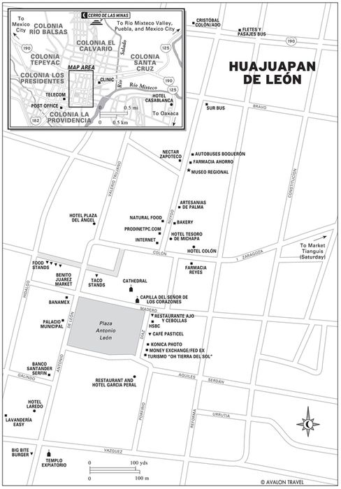
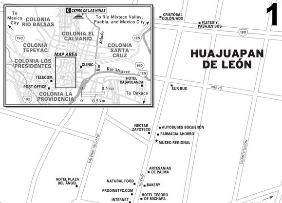
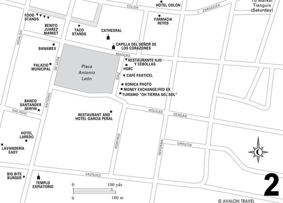
The plaza’s major source of early-evening entertainment is the army of birds, mostly black grackles, who around sunset head from all directions straight for the big, bushy plaza trees. For about an hour, they flutter, cackle, and squabble for perches until they finally settle down for the night.
Stroll over for a look inside the cathedral. For Mexico, this is a new church. Earthquakes repeatedly damaged the previous structures occupying the site since colonial times. The present church, built in the late 1800s, was so severely damaged by earthquakes that it had to be extensively rebuilt and earthquake-proofed in the 1960s. But for the people of Huajuapan, it’s not the building, but what it contains, that counts.
Inside, a brilliantly illuminated Virgin of Guadalupe occupies the main front altar, while in the right-side chapel, the Capilla del Sagrario del Señor de los Corazones, a painted celebration of baroque glitter climaxes in the beloved, dark-complexioned Señor hanging limply above the altar. On auspicious days, the faithful arrive in a near-continuous stream to pay their respects. As you leave, look on the wall in the small sub-chapel on the left, just outside the door, for the heart festooned with little metal milagros (wish offerings), which beseeching pilgrims have left for the Señor.
 Cerro de las Minas Archaeological Zone
Be sure to spend at least an hour investigating the remains of Cerro de las Minas, a major urban-stage (A.D. 300–800) Mixtec town. Artifacts uncovered on this hill just north of town during the 1980s demonstrate characteristics of so-called Ñuiñe glyphs, which archaeologists recognize as one of the five unique writing systems of ancient Mesoamerica.
Similar finds unearthed at contemporaneous Mixteca Baja ruined cities, such as Tequixtepec, Chazumba, Miltepec, Suchitepec, Lunatitlán, and Mixtlahuaca, led archaeologists to name the style by the Mixtec label, Ñuiñe (nyoo-EE-nyay), for the “Hot Country,” the Mixteca Baja, where they were discovered.
Before charging up the hill, however, first visit the Huajuapan Regional Museum (Museo Regional de Huajuapan; Nuyoo 15, no phone, www.mureh.org.mx, 10 A.M.–2 P.M. and 4–8 P.M. Tues.–Sun.), half a block uphill from the church. Professionally prepared exhibits on the bottom floor give an overview and explanations of the exquisite finds at Cerro de las Minas. Upstairs is a library and beautifully displayed life-size mock-ups—community, costumes, economics, fiestas, religion, and work—of present Mixteca Baja people. Another room exhibits a graphic post-Conquest history and culture of Huajuapan up to modern times, including a description of the interesting tradition of tequio (community volunteer work). The museum also sells some books of local history and culture, notably archaeologist Marcus Winter’s Cerro de las Minas guide to the ruined city uphill.
EXPLORING THE SITE
After the museum, get to the ruins by driving, hiking, or hailing a taxi. Wear sturdy walking shoes, a hat, and take water. From the town center, follow Nuyoo north across the highway and three blocks past the uphill church. Continue straight ahead, up a steep track and turn right to the parking lot, marked by a Zona Arqueología sign. From there, on foot, scramble uphill past the retaining wall to the highest point, Mound 1, on the east side.
From the top, the entire Huajuapan Valley spreads in all directions. On the south side, in the distance, rise the downtown cathedral’s ruddy twin towers. Far behind them stand the cloud-draped heights of the Mixteca Alta. On the opposite, north side, flat-topped Cerro Yucunitza, the site of another hilltop ruined city, towers over the valley. Below Yucunitza’s right shoulder, the Río Mixteco meanders below the high brushy hills of the Mixteca Baja.
Unrestored Mound 1, most certainly a former pyramid, slopes downhill past some reconstructed walls and stairs to a wide ceremonial courtyard. Descend Mound 1 to the courtyard. On its north side are the previously excavated Tombs 4 and 5. On the south side, a staircase descends to a smaller courtyard complex of what appear to be residential walls and patios. Continue west to Mound 2, a partly reconstructed ceremonial pyramid. Looking south toward town from its summit, you can view the clear outlines of a partially excavated ball court about a hundred yards down the slope.
Continue west, descending the regal, restored ritual staircase down the west side of Mound 2 to a grand 100-yard-square courtyard. Ahead rises Mound 3, a brushy hill that most certainly conceals yet another staircase and pyramid summit.
The visible hilltop remains of Cerro de las Minas around you were the ceremonial hub of a small city that, at its apex around A.D. 500, was home to perhaps 4,000 people whose hundreds of homes extended over scores of surrounding hillside acres. Like many of Oaxaca’s forgotten cities, the city’s original name has been lost over time. What archaeologists do know, however, is that, like Monte Albán and several other of Oaxaca’s ancient cities, the inhabitants of Cerro de las Minas mysteriously abandoned it around A.D. 800.
Las Campanas
Las Campanas park, a lovely streamside stroll on Huajuapan’s northwest outskirts, is worth at least an hour’s visit. At Las Campanas, community efforts have preserved a unique natural desert-like spring and habitat, decorated with rock outcroppings and ferny, shaded nooks. Tables beneath streamside willows make for restful picnicking.
The name Las Campanas (The Bells) derives from the stalactites hanging from the ceilings of shallow, streamside caves. If struck just right, a stalactite will vibrate and ring with a soft, bell-like monotone.
(Note: Experienced cavers and hikers might enjoy exploring the cave complex upstream from Las Campanas. A large tree, locally known as Palo Blanco, marks the entrance. The cave extends a mile or two uphill to around Agua Dulce village. Ordinary travelers should only attempt this led by an experienced guide. For information and guide recommendations, check with the municipal museum director and/or the tourism office at the presidencia municipal.)
Las Campanas, although readily accessible, is not well marked and is easy to miss. Follow the road to Mexico City about 1.6 kilometers (one mi) west of Huajuapan town center. Las Campanas nestles in a shallow arroyo on the left, marked by a left-side (heading in the Mexico City direction) short driveway, leading to a small parking lot. If you pass a government vivero (nursery) on the left, you’ve gone too far; turn around and return one block to Las Campanas.
Shopping
If it’s Wednesday or Saturday, the days of Huajuapan’s huge tianguis (native town market), which is so big that the local government had to move it to the western outskirts of town, it’s best to get there by taxi ($3). Stroll beneath the acres of shady tianguis (literally, awnings) for your pick of the best, from mounds of luscious bananas, tomatoes, cucumbers, and squashes. During the summer and fall, you’ll also see plenty of pears, peaches, guavas, and grapes. Also admire the piles of deep-red chilies and bright-yellow flor de calabaza (squash flower) used for flavoring soups and stews. Here and there, you’ll glimpse piles of old-fashioned items, such as corn husks (for wrapping tamales), cal (lime or quicklime) for soaking corn, red jamaica (hah-MAHEE-kah) petals for delicious drinks, nopal (cactus leaves), tamarindo and guaje pods, yellow manzanilla (chamomile) flowers, and hunks of panela (brown sugar). Throughout your walk, take note that the women vendors are definitely in charge, although few wear traje (traditional indigenous dress).
You’ll also find some handicrafts. Locally made items include red- and black-streaked pottery, in practical shapes such as ollas (pots), bowls, and comales (griddles); and stone, carved into manos (rollers), metates (basins), and mol-cajetes (mortar and pestle) for grinding corn and chilies. Local folks also sell plenty of items woven from palm. These include sombreros, bolsas (purses), petates (mats), and cestas (baskets).
Although few if any local people make textiles, they do import and sell, mostly huipiles, from other parts of Oaxaca. You’ll probably find some on Wednesday, if you look around the covered section.
Back downtown, on the five non-tiangius days (Sun., Mon., Tues., Thurs., and Fri.), you can still enjoy much the same as at the tianguis, by meandering the aisles of the downtown Mercado Benito Juárez (west side of Trujano), three blocks north of the plaza.
Furthermore, a pair of small stores on Nuyoo, in the town center, offer handicrafts. First, take a look at the woven-palm treasures of the precious little Artesanías de Palma (Nuyoo 13, no phone, 9 A.M.–6 P.M. daily), half a block uphill from the cathedral. Stop by and pick a few items from their selection of old-fashioned dress-up costumes, cowboy hats, and calabazas for carrying water. Uphill, across Nuyoo from the museum, the mezcal shop Nectar Zapoteco (Nuyoo 20, tel. 953/522-0133, 8 A.M.–10 P.M. daily) also stocks some attractive Valley of Oaxaca handicrafts. These include pottery from Atzompa and Coyotepec, leather, and mezcal, in dozens of flavors.
Accommodations
UNDER $25
The budget hotels (none of which accept credit cards) dot the downtown, along Nuyoo and Colón, near the second-class bus stations. Hotel Colón (Colón 10, tel./fax 953/532-0817 or 93/532-1860, $15 s, $22 d one bed, $28 d two beds, $31 t), on the north side of the church, is probably the best super-budget choice. It offers about 20 clean but smallish dark rooms, with cable TV, hot-water shower-baths, all around a parking patio, with gratis songs from the owner’s bird flock, and a restaurant on site.
Another recommendable budget choice is the Hotel and Restaurant El Tesoro (Nuyoo 7, tel. 953/532-4501, $17 s, d one bed, $22 d, t, and q two beds). Choose from around 20 basic rooms with baths, around an inviting plant-decorated restaurant patio, also embellished by birdsong. Clean but small rooms, with TV, in-house Internet, and good restaurant, but no parking, are set back from the busy street and consequently insulated from traffic noise.
For another economical choice, take a look at Hotel Laredo (Antonio de León 13, Colonia Centro, just a block south of the plaza, tel. 953/532-0402, $17 s or d one bed, $25 d or t in two beds). The 40 rooms, stacked in three levels around a convenient but morning-noisy parking courtyard, are plain and less than immaculate. If not acceptable, ask them to clean up what’s wrong before paying. Amenities include bath, fan, parking, and a passable restaurant.
$25–50
High marks go to suburban resort-style  Hotel Casa Blanca (Amatista 1, Colonia Sta. Teresa, tel. 953/532-0779 or 953/532-9364, fax 953/532-0979, $26 s or d in one bed, $50 d in two beds, $60 t), on Highway 190, Oaxaca City side, about 1.6 kilometers (one mi) east of downtown. This is a comfortable option for drivers anxious to avoid downtown traffic and save money. The Casa Blanca’s 70 semi-deluxe rooms, in a pair of two-story wings in a spacious garden complex, are carpeted and comfy. Amenities include hot-water shower-baths, cable TV, fans and air-conditioning, relaxing pool-patio, good, airy restaurant, parking, and phones; credit cards are accepted.
If you must stay downtown, but can’t find anything else, you can settle for a night in the Hotel Plaza del Ángel (Valerio Trujano 22, tel./ fax 953/532-0851, $24 s, $32 d, $40 t). Although not much to look at from the outside, the Ángel has carpeted, and therefore quiet, hallways. Rooms, plain but clean, have private hot-water baths, cable TV, fans, in-house Internet, parking, but no phones nor credit cards accepted.
OVER $50
Visitors who enjoy soaking up Mexico in comfort should choose the immaculate, class-act  Hotel Garcia Peral (Porfirio Díaz 1, tel. 953/532-0777 or 953/532-0742, fax 953/532-2000, hotel_garciaperal@hotmail.com, www.garciaperalhotelrestaurant.com, $41 s, $53 d, $70 t), by the southeast corner of the central plaza. The 37 rooms in three floors surround an inviting pool patio blooming with tropical plants and birdsong. Rooms are comfortably furnished, with beige bed covers, reading lamps, attractively rustic tile floors, and modern-standard bathrooms. Amenities include fans, a good restaurant-bar, pool and sauna, and parking; credit cards are accepted.
Food
Huajuapan’s best grocery, vegetable, fruit, and economy meals source is the downtown Mercado Benito Juárez, (west, on Trujano), two blocks north, from the plaza’s northwest corner. For wholesome cooked specialties, visit the airy andador de fondas walkway on the Benito Juárez market’s north side.
On the other hand, health food fanciers can get plenty of honey, grains, juices, soya, vitamins, supplements, granola, and yogurt at Natura (Nuyoo 18, tel. 953/532-2538, 9 A.M.–9 P.M. Mon.–Sat.), a block uphill from the cathedral. Satisfy your hankering for cake, pie, and cookies at the bakery, Espiga de Oro (Nuyoo 9, tel. 953/532-3432, 7 A.M.–10 P.M. daily), half a block uphill from the cathedral.
The town center abounds with wholesome cooked food. For inexpensive snacks and meals, try the taco stands, on the corner northwest of the church. On the other hand, cross Colón and walk up Nuyoo a few doors and step into the sheltered patio of the hotel and Restaurant El Tesoro de Michapa (Nuyoo 7, tel. 953/532-4501, $4–9). Here, you can enjoy a good home-cooked meal accompanied by the melodies of the owner-chef’s pet tropical birds.
A cluster of good restaurants serve customers on the east-side plaza-front. In succession, moving south, across from the plaza’s northeast corner, first find the Starbucks-like Italian Coffee Company (tel. 953/530-5742, 8 A.M.–10 P.M. daily, $1–8). Step into the cool, comfortable interior for a light lunch of either delicious pizza or panini, followed up by a selection of luscious cookies, cakes, and savory café Americano.
Directly upstairs from Italian Coffee Company, on the 2nd floor, you can enjoy both good food and a superbly airy sunset-view and plaza-front perch, at century 21-mod Zona Zero (tel. 953/532-0795, 8 A.M.–mid-night daily, $8–14), and be entertained with techno tunes and continuously lively TV monitors. As for food, choose from an innovative international menu of breakfasts, soups, salads, pastas, seafood, and meat.
Relaxing courtyard ambience, quiet music, and genteel conversation draw a steady stream of middle- and upper-class patrons to  Cafetería Pasticel (two doors south of Zona Zero, next to HSBC, tel. 953/532-2161, 8 A.M.–10 P.M. daily, $3–7). Here, diners start off the day with strong Oaxaca espresso coffee and hearty breakfasts (hotcakes, eggs), and enjoy lunches and suppers of American-style sandwiches (hamburgers, hot dogs, and club) and hearty Oaxacan-style specialties (chicken enchiladas, chilaquiles, tacos).
For refined hotel dining, try the airy plaza-view corner restaurant of the Hotel Garcia Peral (tel. 953/532-1532, 8 A.M.–10:30 P.M. daily, $7–15). Pick from the long recognizable menu of everything, from cream of asparagus soup and club sandwiches to shrimp salad, filet mignon, or enchilada Oaxacan-style, smothered in black mole sauce.
Information and Services
A number of banks around the plaza, all with ATMs, change money. Best for its long hours is HSBC (on Porfirio Díaz, tel. 953/532-0169, 9 A.M.–6 P.M. Mon.–Fri., 9 A.M.–3 P.M. Sat.), across from the plaza’s northeast corner, south of the church.
If somehow HSBC isn’t satisfactory, walk a block to Banamex (tel. 953/532-1282, 9 A.M.–4 P.M. Mon.–Fri.), at the plaza’s northwest corner.
Get to the correo (5 de Febrero 16, on the south side, tel. 953/532-0692, 8 A.M.–4 P.M. Mon.–Fri., 9 A.M.–noon Sat.) from the plaza’s southwest corner, by walking south on de León three blocks to 5 de Febrero; turn right and continue another two blocks to the post office on the left side of the street. The telecomunicaciones (on Galindo, between Hidalgo and Matamoros, tel. 953/532-0584 or 953/532-3577, 8 A.M.–7:30 P.M. Mon.–Fri.), with money orders, telephone, and fax, is southwest of the plaza. From the plaza’s southwest corner, walk a block south, turn right at Hidalgo, and walk a block and a half.
Long-distance telephone and fax are readily available at the money exchange (on the plaza, west side, tel. 953/532-2908, 9 A.M.–4 P.M. Mon.–Fri., 9:30 A.M.–2:30 P.M. Sat.–Sun.); it’s also a Federal Express and copy shop.
Internet connection is available at Prodinetpc.com (Nuyoo 12A, tel. 953/532-2724, 9 A.M.–9 P.M. daily).
If you get sick, one of the best places to go for a doctor is the Centro de Especialidades de la Mixteca (Zaragoza 24, tel. 953/532-1355, consultations: 9 A.M.–8 P.M. Mon.–Sat.), three blocks west of the plaza. It has about 15 specialists on call, from gynecologist and pediatrician to internists and a cardiologist.
For routine remedies and prescriptions, go to one of the several pharmacies near the plaza, such as Farmacia San Jorge (on Colón, behind the church, tel. 953/532-1399, 8 A.M.–11 P.M. daily), or its second branch (Nuyoo 20, half a block north from the church, tel. 953/532-1123 or 953/532-1584, 8 A.M.–11:30 P.M. daily).
Although Huajuapan has a city turismo office on the upper floor of the presidencia municipal on the west side of the plaza, you might get more good information by consulting friendly José Flores Cubas, owner of the Turismo “Oh Tierra del Sol” (at the plaza’s southeast corner, tel./fax 953/532-4555, ohtierradelsol@hotmail.com, 8:30 A.M.–7 P.M. Mon.–Sat).
Get your wash done at Lavandería Easy (on Hidalgo, 8 A.M.–8 P.M. Mon.–Sat., 9 A.M.–8:30 P.M. Sun.), one block west, one block south from the plaza’s southwest corner.
Getting There and Away
Several first- and second-class bus lines operate out of various terminals, providing direct connections with many Oaxacan and national destinations. The busy, nearly all-first-class bus terminal (Hwy. 190 intersection with Nuyoo, tel. 953/532-9309), six blocks north of the plaza, is the hub for Omnibus Cristóbal Colón, Autobuses del Oriente (ADO), Sur, and Autobuses Unidos (AU) ticket sales, arrivals, and departures. Principal connections, including many intermediate destinations, are southeast with Nochixtlán and Oaxaca City; south via Highway 182 and Tonalá with Juxtlahuaca, where you can transfer on to Tlaxiaco, Putla, and Pinotepa Nacional; and northwest with Puebla and Mexico City.
Second-class Fletes y Pasajes (on the highway, across the street, west from the ADO station) offers a broad range of connections in Oaxaca, approximately the same as Sur.
Also, the old (1960s) buses of backcountry bus line Boqueron (on Hwy. 182, west edge of town, take a taxi) offer about three connections daily, along the north–south Tonalá–Juxtlahuaca–Putla route all the way to Pinotepa Nacional, on Oaxaca’s Pacific coast.
Some independent bus and van stations are scattered along Nuyoo, along the blocks north of the cathedral.
Autobuses Erco (Linea Oro, Nuyoo 19, tel. 953/532-1513) offers first-class express connections with northern destinations of Izucar de Matamoros, Puebla, and Mexico City.
A pair of long-distance van services also provide oft-frequent fast connections. Servicios Turísticos Huajuapan (Nuyoo, tel. 953/554-0813) provides broad connections, southeast, with Highway 190, to the destinations of Tamazulapan, Nochixtlán, and Oaxaca; and south, along Highway 182, with Tonalá and Juxtlahuaca.
Furthermore, Servicios Turísticos Teposcolula (Nuyoo, local cell tel. 044-953 /110-4025) provides connections southeast with Tamazulapan, thence south along Highway 125, with Teposcolula and Tlaxiaco. Find them both, on Nuyoo, about three blocks north of the church, across from the big Farmacia Ahorros.
Drivers have their pick of four major paved highways radiating from Huajuapan. Northwest, Highway 190 connects with Mexico City—316 kilometers (196 mi) via Cuautla, Morelos. Two winding lanes and numerous big trucks along the way usually slow traffic on route. Figure about seven hours under good conditions, in either direction. A quicker alternative is to first head northeast via Highway 125, 118 kilometers (74 mi), two hours, to Tehuacán, Puebla. There, connect with the cuota autopista, which will whisk you in another three hours, via Puebla, to Mexico City.
For Oaxaca City, follow Highway 190 for 113 kilometers (70 mi), two hours, southeast to Nochixtlán. Continue via the cuota autopista to Oaxaca City, another 80 kilometers (50 mi), about one additional hour.
Drivers can also access points directly south most easily via Tonalá, along the paved (but sometimes potholed), lightly trafficked secondary road, Highway 182, which takes about two hours to Juxtlahuaca (100 km/62 miles). South of Juxtlahuaca 40 kilometers (25 mi; one hour), at the Highway 125 junction, either head left (east) along Highway 125 another 34 kilometers (21 mi), to Tlaxiaco, or go right (south) along Highway 125 via Putla to Pinotepa Nacional on the Pacific coast (a total, from Huajuapan, of 332 km/206 mi). Allow six hours’ driving time south to the coast, four hours to Tlaxiaco.
NORTH OF HUAJUAPAN: INTO THE ÑUIÑE REGION
National Highway 125 winds north along the rural, tree-shaded valley of the Río Mixteco, passing a sprinkling of little towns, sleepy except during fiestas, when they liven up with days of processions, barbecues, and carnivals. Along this route, interest climaxes at San Pedro y San Pablo Tequixtepec, where townsfolk welcome visitors to explore their community museum. There, you can view the Ñuiñe-engraved monoliths, whose cryptic inscriptions have convinced archaeologists that they represent a unique written language.
By car, starting early, you could enjoy this 121-kilometer (75 mi) round-trip excursion in a day, allowing time for a picnic in Tequixtepec (35 km/22 mi from Huajuapan) around the midpoint. Bus travelers: Head out by ADO, Sur, or AU bus straight from Huajuapan, on a Tehuacán-bound bus. Ask the driver to let you off at the Tequixtepec entrance road, where you can catch a taxi or the town colectivo van and ride the five kilometers (three mi) to town. Afterward, either continue north or return to Huajuapan stopping along the way, if time allows.
Santiago Huajolotitlán
This small town, 6.4 kilometers (four mi) north of Huajuapan, is well known, both for its annual patronal festival and as the place where the Virgin of Guadalupe appeared in 1978. First, stop at the town church, the Templo de Santiago Apóstol, built between 1835 and 1840. Inside, to the right as you enter, notice the popular San Isidro Labrador, the patron of farmers, animals, and children, with his customary yunta (yoked pair) of oxen and a child. Folks celebrate his memory on May 15, when children bring their animals to church to be blessed.
Also, don’t miss the uniquely quaint town patron, Santiago Caballerito (Little Saint James), mounted on a small horse, waving a big sword. His festival, celebrated July 26–29, usually includes plenty of fireworks, flowers, music, marches, and mañanitas (early morning masses).
Also, on the slope of Cerro del Chilar, northwest of town, is the Capilla de la Virgen de Guadalupe, built over the spot where a shepherd saw the Virgin in December 1978. Thousands of believers subsequently flocked to the site, now relatively unfrequented, where the chapel stands.
Río Mixteco Valley and Asunción Cuyotepeji
North of Huajolotitlán, the winding river valley is especially lush during the cooler summer rainy season, when it’s abloom with fields of vegetables, tall green corn, and waving wheat. The natural charm climaxes at the riverbank itself, decorated by groves of stately ahuehuetes or sabinos (bald cypress trees). Here and there, where the highway nears or crosses the river, pause for a stroll along the river and enjoy a spell in the company of the old shady giants.
During mid-August, you also might enjoy getting in on the fun of the Fiesta de Santa María de la Asunción, at Cuyotepeji, about 19 kilometers (12 mi) north of Huajuapan. At least take a look inside the church, known for its gilded baroque main retablo (altarpiece), crowned by the Holy Mother ascending to heaven guided by a pair of adoring cherubs.
San Pedro y San Pablo Tequixtepec
You could easily spend your entire day at Tequixtepec (formally, San Pedro y San Pablo Tequixtepec, pop. 1,400), the head town of the municipio of the same name. Make your first stop at the community museum, Memorias de Yucundaayee (yoo-koon-dah-ah-YAY-ay; adjacent to the town presidencia municipal, no phone, 10 A.M.–2 P.M. and 4–7 P.M. Mon.–Thurs.), named with the town’s original Mixtec label (Hill of the Standing Conch), which the Aztecs translated to Tequixtepec.
The professionally prepared exhibits display the intriguing glyph-carved monoliths, with Spanish-language explanations of their Ñuiñe writing style. Despite a generation of study and excavations, archaeologists still can say little about the people depicted. For now, their feathered visages remain mute to us; maybe someday experts will decipher the Ñuiñe glyphs and understand their messages.
See COHETES: BANGS, FLASHES, AND HISSES IN THE NIGHT
The recently completed mural on the museum’s front wall depicts the sweep of Tequixtepec history, from pre-Conquest times, through independence, civil war, and reform, clear up to the 20th century, when the tradition of the town’s beloved Señor del Perdón began in 1917–1918.
If you have arranged a tour appointment, a museum volunteer will be available to take you on an extensive exploration, including a three-hour round-trip hike to Cerro de La Caja (Mountain of the Box), a regal hilltop ruined town. There, among other things, you’ll be able to inspect a ponderous box-like monolith, inscribed with a number of graphic Ñuiñe reliefs, one of which includes a personage devouring a captive. Make an appointment by leaving a message, specifically for the museo comunitario, with the town long-distance caseta (long-distance within Mexico tel. 200/123-7044, 200/123-7045, or 200/123-7046).
Back in town, be sure to visit the church, dedicated to the Señor del Perdón (Lord of Forgiveness), who is celebrated in a big regional fiesta and pilgrimage culminating on the second Friday of Lent. At that time, 20,000 people are likely to crowd into little Tequixtepec, sleeping in the plaza, the town pilgrimage shelter, and in scores of buses parked along the road into town. The object of all is to ask forgiveness from the Señor del Perdón, who presides above the church’s front altar.
Before you leave, ask your guide for a demonstration of palm weaving, which many townsfolk do during their spare moments. Both individual weavers and the museum sell examples of woven sombreros, petates (mats), tenates (tumpline baskets), and more. Additionally, be sure to step 100 years into the past into the Porfirian-era store of grandfatherly Faustino “Tino” Moran Castillo in the center of town opposite the church. Here you might say a good word, make a small purchase, and enjoy a sip of his zingy homemade brandy, which Faustino claims is “very good for your health.”
Hint: If you happen to arrive in Tequixtepec unannounced, Faustino is the one to see first, and can usually find someone to open the museum for you. Furthermore, if you decide to linger in Teqiuxtepec, Faustino and his daughter Abigail are prepared for you. He offers a room in his house for $10 per person, and given a day’s notice will arrange for meals for $4 per person. Kindly place a reservation via the town long-distance telephone (tel. 200/123-7044, 200/123-7045, or 200/123-7046).
Santiago Chazumba
The main yearly attractions here at sleepy Chazumba, about 60 kilometers (37 mi) north from Huajuapan, are its two major festivals, in honor of Santiago (July 24–26) and the Señor de Esperanza (Lord of Hope—the 15 days beginning on Good Friday).
The town’s permanent jewel is its church, dedicated to Santiago Apóstol (St. James the Apostle). Although it seems a small miracle that such a monumental building and refined works of art can be found in such an isolated little place, it is the Chazumba townsfolk’s intense devotion, rather than divine intervention, that has produced the monumentally resplendent results over centuries of effort. While inside, among all the glitter, don’t miss the baptismal chapel to the right of the front door, the Señor de Esperanza in the transept chapel, and Santiago above the front altar.
The Chazumba bus stop supports a few eateries alongside Highway 125. The best seems to be the Restaurant Los Arcos (tel. 953/525-0083, 7:30 A.M.–9 P.M. daily), where you can enjoy house specialties, such as mole de guajalote (turkey with mole sauce), tamales de frijol (bean tamales), and barbacoa (barbecued beef, pork, or chicken).
Besides food, Restaurant Los Arcos also provides a long-distance telephone and fax (tel. 93/525-0083). Moreover, in town you’ll find a correo (across the highway, 9 A.M.–1 P.M. and 3–6 P.M. Mon.–Fri.) and a telégrafo (9 A.M.–3 P.M. Mon.–Fri.) for money orders and fax.
ADO and AU buses, which depart from the Restaurant Los Arcos, connect several times a day north with Tehuacán, Puebla, and Mexico City, and south with Huajuapan, Nochixtlán, Oaxaca City, and intermediate points.
SOUTH OF HUAJUAPAN: ALONG THE HIGH ROAD TO THE MIXTECA ALTA
This lightly traveled, all-paved (but sometimes potholed) route, National Highway 182, branches south from Huajuapan, opening a scenic back door to Oaxaca’s cool, green, and culturally rich Mixteca Alta. Along the way, you’ll cross rushing mountain rivers, wind through fertile farm valleys, and climb to high ridges where you can gaze back down upon it all.
Pleasant surprises along the way include boating, fishing, camping, and lakeside bungalows at Yosocuta Reservoir and riverside hiking and wilderness camping in spectacular Tonalá Canyon. A few miles farther, at colonial-era Tonalá town, you can enjoy a cool, shady walk, and a picnic in the town’s grand old sabino (bald cypress tree) grove. Finally, at the route’s end, at Juxtlahuaca, enjoy the color of the grand indigenous Thursday–Friday tianguis (native town market), a relaxing stroll, and restful overnight camping in the pine grove beside the crystalline, emerald-green Laguna Encantada. With an extra three hours, you can even go for an easy but amazing walking adventure through the stalactite-hung grottoes of the limestone cave at nearby San Miguel de la Cueva village.
Yosocuta Reservoir
This big artificial lake, 13 kilometers (eight mi) south of Huajuapan, confined by the government-built Yosocuta dam on the Río Salado, rises and falls with the seasons. From February through June, the reservoir drains, nourishing irrigated crops downstream. Its level consequently falls, leaving an ugly bathtub-like lakeshore ring. However, by October, the lake usually refills to its brim, gently lapping the shoreline at Parador Yosocuta, the major lakeside access point.
Here, you have several choices. Lake-view restaurants offer snacks, drinks, and fresh lo-bina negro (black bass) dinners. A concession, owned by the Yosocuta town fishing cooperative and managed by welcoming Sammy Martínez, offers lake tours by boat ($10–15 per party), fishing excursions ($20/hour), boat rentals, bait, and fishing poles (for sale for about $50); launching fee for your own motorboat runs about $5.
If you decide to stay overnight, Sammy will let you set up your tent on the lakeshore ($2 pp) or park your self-contained RV overnight in the parking lot for free. He also rents out cozy lakeshore four-person duplex cabins (which he calls bungalows, $12 pp per night), with their own hot-water baths and porch-front hammock hooks.
Furthermore, if somehow Lake Yosocuta doesn’t suit you, stop instead at the Balneario las Bugambilias (10 A.M.–6 P.M. daily, no phone, $6 adults, $3 under 12), a family paradise of pools, water slides, merry-go-round, a restaurant, and a campground. It might be crowded on Sundays and holidays. The balneario (resort) is located on the highway, past the town of San Marcos, about eight kilometers (five mi) west of the reservoir.
Also along the road, at San Marcos village, you must stop for a treat at  Panadería San Marcos (7 A.M.–8 P.M. daily), on the highway at the south edge of San Marcos village, a few kilometers past (west of) Yosocuta (but before the balneario). Here, you can savor what has to be the Mixteca’s, if not all of Oaxaca’s, best pastries.
About half a mile before reaching Tonala Canyon, a rustic restaurant, Comdeor Boquerón, provides a pleasant place to pause, offering food, drinks, and a panoramic view of the Río Salado valley.
Tonalá Canyon
Past a high, pine-studded ridge and pass, Highway 182 winds down to the fertile, green, Tonalá valley. There, 43 kilometers (27 mi) south of Huajuapan, beneath the foot of Puente Morelos, a steel-arch highway bridge, the Río Salado issues through the deep defile of Cañon de Tonalá (known locally as El Boquerón—Big Mouth).
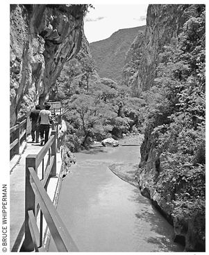
A sturdy walkway leads through El Boquerón, the grand river gap of the Río Salado.
A trail (and aqueduct) cut into the canyon wall leads to a diversion dam about 1.6 kilometers (one mi) upstream. The trail begins at some stairs not far from the bridge’s north footing. It continues spectacularly, above the river along the diversion canal, winding beneath towering 300-meter (1,000 ft) moss-mottled cliffs, green-tufted like a classical Chinese painting. At one point, a great boulder overhangs the trail; at another, a mass of ferns appears to cascade from the vertical rock wall.
At the dam, the trail ends at a small park and commemorative plaque that records that President Gustavo Díaz Ordaz came here during the late 1960s to dedicate the dam, a part of the federal Río Balsas Basin Development Project. A rough informal trail continues past the dam. After 50 downhill yards it leads to a flat spot on the right good for camping, with a bit of shade and safely above the river.
For equipped and prepared wilderness adventurers, the river farther upstream, which runs about 16 kilometers (10 mi) through a wild, deep gorge, might be heaven. Overhead, vultures and eagles soar; coyotes, foxes, and wildcats hunt along the shore; and butterflies flutter among streamside trees and wildflowers. The river, rushing and often muddy during the summer rainy season, slows to a clear, tranquil creek during the dry winter and spring. Although the Yosocuta Dam upstream probably minimizes the hazard, hikers should be aware of possible flash flooding from upstream thunderstorms.
 Santo Domingo Tonalá
The sleepy farm community of Santo Domingo Tonalá (pop. 3,000) owns a pair of gems: its 16th-century Dominican-founded church and ex-convent, the Templo de Santo Domingo, and the shady, sylvan sabinera (cypress grove) behind the church. First, take a look inside the church, behind its front garden, a block north of the town plaza. Just past the entrance hangs an intriguing portrait of Angel Gabriel holding the scales of justice, deciding which of a cluster of beseeching souls will be admitted to Paradise. Farther on stands an image of the beloved African Dominican padre San Martín de Porres. The treasures climax in the right-side chapel, in a glittering, gorgeous small retablo (altarpiece), appearing as intricate as filigree and dedicated to the Holy Sacrament. Continue outside to the church’s right (east) side and enjoy a turn through the garden within the old convent cloister.
You’ll find the sabinera two blocks behind the church. Stroll around and soak in the cathedral-like loveliness beneath the ancient trees. Perhaps you will agree that the magnificent, gnarled old veteran sabinos, or ahuehuetes, are in their own way as magnificent as the stately old-growth groves of their cousins, the California redwoods. They certainly approach the size of redwoods. At the grove’s far west end (left as you enter), find the rugged old grandparent of them all, 4.5 meters (15 ft) in diameter and 15 meters (50 ft) around. During your walk, you probably will notice the several small, clear rivulets running through the grove. This is no coincidence; local folks believe sabinos to be the most intelligent of trees; they always grow where the water flows.
If you arrive on Sunday, you might be able to see a pelota mixteca ball game in the field across the highway at the town entrance road. A direct descendant of the ancient Mesoamerican tradition, the modern game has players batting a big rubber ball back and forth, by hand, not unlike tennis (except without a net or a raquet).
Furthermore, you’re in for a treat if you arrive in early May or early August, when Tonalá wakes up for its annual festivals. Between May 1 and May 4, you can get in on the fun (dancing, cockfights, and bull roping and riding) of the Fiesta de la Santa Cruz. Three months later, around August 4, join Tonalá folks as they rev up again for more of the same during the Fiesta de Santo Domingo.
Ecotourism
What’s more, Santo Domingo Tonalá has been increasingly welcoming to visitors. Besides camping, hiking, and wildlife-viewing opportunities in Tonalá Canyon, you can enjoy guided tours of local archaeological sites. These include a cave with pinturas rupestres (prehistoric hieroglyphic rock paintings), and walls of ancient crumbling temples (from a time long ago, when the local population is said to have migrated from present Chiapas state).
For information on all this, drop by the local ecotourism office (in the Tonalá presidencia municipal, tel. 953/531-0023, in Spanish), where Artemio Cruz is in charge. They now have hiking trails for guided tours, navigable either on foot or by mountain bike; and in Tonalá Canyon, a riverside campground and cabañas for overnight accommodations.
Accommodations and Food
Consider Tonalá’s one hotel, the homey Los Mangos (Lázaro Cárdenas 27, tel. 953/531-0023, $15 s, $18 d in one bed, $22 d or t in two beds), marked by a tall mango tree, on the entrance road from the highway. The grandmotherly owner and her daughter offer 10 rooms beside a flowery garden and the loveliest of crimson-blossomed tabachínes (flame trees). Check the rooms before moving in; mildew can be a problem here, especially during the rainy summer. Ask for fresh linens if necessary. All rooms have baths, with 24-hour hot water and all the mangos you can eat, in season.
For groceries and fruits and vegetables, go to well-stocked Comercial Itzoca (Lázaro Cárdenas, tel. 953/531-0138, 8 A.M.–9 P.M. daily), in the northwest corner of the plaza.
The best place in town for hearty home-cooked meals is the Los Mangos hotel’s restaurant (Lázaro Cárdenas 27, tel. 953/531-0023, 8 A.M.–8 P.M. daily, $3–8).
Information and Services
Most of Tonalá’s essential services are on Lázaro Cárdenas, near the town plaza. For example, if you’re sick, go to the centro de salud (8 A.M.–2 P.M., 4–6 P.M. Mon.–Sat.), downhill a block past the church. Alternatively, consult with Doctora Aracel Orate at her Farmacia Diana (across from the centro de salud, pharmacy: 8 A.M.–9 P.M. Mon.–Sat., 8 A.M.–3 P.M. Sun.).
Find both the correo (9 A.M.–2 P.M. Mon.–Fri., 9 A.M.–1 P.M. Sat.) and the telecom (8 A.M.–3 P.M. Mon.–Fri.) on the plaza, by the presidencia municipal. For long-distance telephone and fax go to the larga distancia (Lázaro Cárdenas, 9 A.M.–9 P.M. daily), a block downhill from the church, on the right.
For lots of digital photo services, go to Foto Studio Tonalá (local cell tel. 044-953/531-0307, 10 A.M.–4 P.M. and 5–9 P.M. Mon.–Sat.), a block south of the plaza.
Getting There and Away
Bus passengers can reach Yosocuta, Tonalá Canyon, and Tonalá town by second-class Sur (choose Sur) or Boquerón buses, either northbound for Huajuapan or southbound for Juxtlahuaca. By van, Servicios Turísticos Huajuapan picks up southbound (Juxtlahuaca), or northbound (Huajuapan) passengers.
From Huajuapan, drivers should first take the Mexico City direction along Highway 190 to a signed Highway 182 Juxtlahuaca (or Tonalá) left turn, about 1.6 kilometers (one mi) west of the city center. After another 1.6 kilometers (one mi) turn right at the main street, Avenida Mina, and head out another 13 kilometers (eight mi) to Yosocuta. After a total of 43 kilometers (27 mi), arrive at Tonalá Canyon; continue another five kilometers (three mi) to Tonalá town, continuing to Juxtlahuaca, a total of 100 kilometers (62 mi) to Juxtlahuaca. Heading in the reverse direction, north from Juxtlahuaca, the distances total approximately 51 kilometers (32 mi) to Tonalá, 56 kilometers (35 mi) to Tonalá Canyon, and 87 kilometers (54 mi) to Yosocuta. Figure about two hours at the wheel, either direction.
SANTIAGO JUXTLAHUACA AND VICINITY
Santiago Juxtlahuaca (pop. 30,000) is the largest town and major service and governmental center for the Juxtlahuaca governmental district. It’s clear why the town has prospered. It nestles in a deep, fertile valley between a pair of towering oak- and pine-studded mountain ranges. Main roads branch south, west, and north, connecting Juxtlahuaca with the outside world.
A second glance at the surrounding mountains reveals sinuous trails so steep that it’s a wonder how anyone could climb them. But people do—the indigenous Mixtec- and Trique-speaking mountain people, for whom Juxtlahuaca’s big tianguis (native town market) is the focus of their week. They rise long before dawn and bundle up their merchandise—perhaps a basket packed with flowers, potatoes, or carrots; maybe they pile on a few handloomed bright-red-striped huipiles. Husband and wife sling the loads on their backs, adjust the tum-plines on their foreheads, and begin the steep trek downhill, with hope that this will be a good tianguis, and they won’t have to haul everything back uphill tomorrow night.
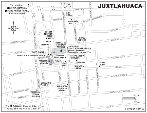
Sights
Orient yourself by the tall, straight-laced bell tower of the town church, the Templo de Santiago Apóstol, visible from all over town. The church faces the customary west, downhill. If you stand looking at the church-front, south will be on your right, north on your left. The uphill direction, toward the rear of the church, is east. Main east–west streets are Libertad, which runs along the church’s north side; Porfirio Díaz, along the church’s south side by the plaza; and Benito Juárez, along the plaza’s south side. Important north–south streets are Lázaro Cárdenas, a block behind the church; and Independencia, a block farther east, uphill.
If at all possible, schedule your Juxtlahuaca visit to coincide with its two-day tianguis (native town market), big on Thursday, but among Oaxaca’s biggest on Friday. Vendors’ awnings (known in the Aztec language as tianguis) stretch from curb to curb, beginning at the town plaza just downhill from the church, and overflow, filling half of Juxtlahuaca’s south-side streets.
The star actors of the tianguis are the Trique women, who proudly wear their horizontally striped bright-red wool huipiles over their black woolen skirts. (If you wonder why in sunny Mexico they wear wool, it’s because afternoons are often cloudy and cool in Juxtlahuaca, especially during the summer and fall rainy season, and doubly so in the Triques’ mountaintop villages.)
A number of Trique women congregate in the town plaza, north side, and display their for-sale homespun textiles: huipiles, black enredos (skirts), and blouses. They don’t like having their pictures taken.
From the plaza, plunge into the hubbub of stalls on the south-side street, Benito Juárez. Along your meandering path you’ll find loads of lovely fruit, many exotic tropical varieties—anonas, guanabanas, pitahayas, zapotes—but also apples, grapes, peaches, pears, and plums in the summer and fall.
You’ll also see a fair amount of pottery, especially along Calle Lázaro Cárdenas, the north–south street that runs behind the church. Varieties include flower-painted, hard-glazed bowls, cups, and plates from Santa Rosa in the Valley of Oaxaca; green ware from Atzompa, also in the Valley of Oaxaca; and red and black jugs, plates, and bowls from Puebla. A few stalls also sell soft woven palm tenates and petates (tumpline baskets and mats), and sombreros from around Huajuapan de León.
If you’re in the market for authentic masks, go to the shop of master craftsman Alejandro Jesús Vera Guzmán (Lázaro Cárdenas 301 Sur, corner of Melchor Ocampo, tel. 953/554-0060 or 953/554-1424, alexvera_72@hotmail.com, alexvera_72@yuahoo.com, www.alejandromascaras.com.mx), one block east and one block south of the plaza’s southeast corner. His store is adjacent to the southwest corner grocery. He got started creating masks (devils seem to be his specialty) for local fiesta dances; now he sells to the public. His prices aren’t cheap; expect to pay $80 and up. From him, however, you’re getting the genuine article. If you lend him your photo, he’ll even create a mask of you, for around $200.

Master craftsman Alejandro Jesús Vera Guzmán carves a devilish mask.
While you’re strolling around, you might take a look inside the church. Just as you enter the door, look into the small alcove on the right and you’ll see the town patron, Santiago (St. James), sword in hand, on his usual white horse, but this time with a cowboy hat atop his head. Up front, above the altar, you’ll see Santiago in more traditional dress. Step left, into the left transept chapel, and see the Virgen de Soledad presiding above the altar.
 Laguna Encantada
Yet another good reason for coming to Juxtlahuaca is Laguna Encantada (Enchanted Lagoon), a deep crystalline, emerald-green lake beside the Huajuapan highway about three kilometers (two mi) north of town. Laguna Encantada, set like a jewel at the foot of a towering mountain, is a precious asset that, besides furnishing irrigation water, supplies the adjacent communal swimming pool and picnic and camping ground. Even if you don’t camp there, you should at least go for a stroll around its shoreline, made picture-perfect by the family of gnarled old ahuehuete cypresses inhabiting its banks.
(Note: So many men have drowned in Laguna Encantada’s cold deep waters that legend says that Laguna Encantada has the spirit of a woman, who takes men that she likes. Notice the crosses on the inner shoreline, adjacent to the hillside, which is especially treacherous because of its steep drop-off to seemingly bottomless depths. Nevertheless, swimming in Laguna Encantada without accident is doable with precautions: You risk drowning by venturing into such cold water that’s over your head in depth. Play it safe, and confine your workout to either the shallower, outer shoreline, across the lake from the mountainside, or the safe and sane community bathing pool, where you can reach the shore readily in an emergency.)
Both tent and RV camping prospects at Laguna Encantada could hardly be better. A broad cypress-shaded campground on the lake’s north side provides plenty of grassy space to spread out. As a courtesy, ask the caretaker, friendly Natalia Ramos de Morales, or her husband, Francisco, who run the snack stand ($1–4) by the campground and the restaurant on the opposite side, if camping is OK. It will always be both allowed and free; as a courtesy, kindly buy a few tacos and drinks from them at the snack stand, and maybe even a hearty full meal, such as hamburgers, tortas, cappuccino, fresh fish, shrimp, and, on Sundays, scrumptious chili-garlic mole on roast pork.
Natalia recommends that visitors hike up to the top of the hill, Mogote de la Tialeja, just north of the campground. Natalia (a definite local booster) says that the Mogote, an ancient Mixtec town, is full of artifacts (which must remain in place; Mexican law forbids their removal). Artifacts or not, your reward for the 250-meter (750 ft) summit climb will be an airy, panoramic valley and mountain view.
San Miguel de la Cueva
Townsfolk of San Miguel de la Cueva (pop. 1,000), south of Juxtlahuaca, invite visitors to explore their big limestone cave. An adventurer’s delight, the cave has plenty of hanging stalactites, fluttering bats, and a river that flows down from a hidden subterranean lake. Up the road, about 100 yards past the cave, is a petite pretty lake, with picnic shelters, fine for tent or self-contained RV camping. The Río Media Luna (Half Moon), which both enters and exits the tunnel-like cave, provides water (use purification tablets to be safe). A dry path continues about 300 yards through the cave to a separate exit on the north side of a small ridge. With a strong flashlight, good shoes, and a hat, you could hike it yourself, but it’s best to get permission and a guide (offer to donate $10) at the agencia municipal (which has flashlights) in town. Get there via the signed right-side road from Highway 15, three kilometers (two mi) south of Juxtlahuaca. Continue about 13 kilometers (eight mi) to the hilltop town church, on the right. Go one block straight downhill to the basketball court/town plaza in front of the agencia municipal.
To get to the cave, turn right at the bottom of the hill, in front of the agencia municipal, and continue exactly 1.6 kilometers (one mi) along the graded dirt road to the cave, visible downhill on the left, beyond a grassy field of big, beautiful summer lilies.
Accommodations and Food
Juxtlahuaca has several hotels, at least three of which are recommendable. Homiest is the family-run Hotel Mixteco (Independencia 200, tel. 953/554-0025, $11 s, $14 d, $17 t), near the corner of Libertad, two blocks behind the church. The 13 plainly furnished but clean rooms encircle a picturesque mango and lemon tree–decorated patio. Rooms come with hot-water shower-baths and parking; credit cards are not accepted.
Much fancier is the newish Hotel Eden (Calle Mexico 309, tel. 953/554-0706, $20 s, $25 d in one bed, $28 d in two beds, $32 d king-size bed, $33 t), at the corner of Morelos. Choose from three stories of 30 tastefully decorated 1990s-modern rooms, with polished wood highlights, plush maroon carpet, shiny bathrooms, and built-in bed reading lamps, all with hot water, parabolic antenna TV, telephone, and wireless Internet access; credit cards are not accepted. It’s best to arrive in the mid-afternoon, whether you have a reservation or not. This place is popular.
If both of the above hotels are full, you’ll likely find a room at the Hotel Diana (Porfirio Díaz 300, tel. 953/554-1159, $13 s, $18 d in one bed, $22 d in two beds, $25 t), a block downhill from the plaza. The 30 basic but clean rooms come with hot-water shower-baths, TV, and parking; credit cards are not accepted.
As for food, plaza-front taco stands and market fondas (food stalls) provide plenty of inexpensive local-style food. Remember: If it’s hot, it’s wholesome. For dessert, go to the bakery, panadería Erick (Benito Juárez, no phone, 6 A.M.–9 P.M. daily), half a block uphill from the plaza’s northeast corner.
Market vegetable and fruit selection is super, especially during the summer. To be on the safe side, peel, cook, or scrub with soap and water any fruit or vegetable you eat. Stores such as Estrada Fería (Lázaro Cárdenas, tel. 953/554-0026, 9 A.M.–9 P.M. daily), half a block south of Porfirio Díaz and a block uphill from the plaza, opposite HSBC, supply basic groceries.
Juxtlahuaca people are prosperous enough to support a few restaurants. Always busy is the Comedor Dona Tere (behind the church on Lázaro Cárdenas, no phone, 7 A.M.–6 P.M. Mon.–Sat., $4 lunch), a block uphill from the plaza, by HSBC. The specialty here is a hearty afternoon four-course comida, typically soup, rice, stew, and dessert.
Try López Pizza (Lázaro Cárdenas, corner of Santa Cruz, tel. 953/554-1213, 10:30 A.M.–10:30 P.M. daily, $2–7), about four blocks north of the town center, for pizza, spaghetti, calzone, hamburgers, and lettuce and tomato salad.
Alternatively, for tasty Mexican selections, go to spic-and-span Tacos Ruíz (Lázaro Cárdenas, corner of Independencia, 8 A.M.–9 P.M. daily), two blocks closer in than López Pizza.
Festivals
Local townsfolk celebrate both Santiago and the Virgen de Soledad in big festivals. Santiago’s festival culminates around July 25, with a number of traditional dances: the Cristianos y Moros (a variation of the Dance of the Conquest; the Moors are the bad guys); the Chilolos (masked men, posing as women, in bells and skirts); and the town favorite, the Diablos (Devils). Much of the same thing goes on during the December 8 Virgen de Soledad festival. In addition, Carnaval is big in Juxtlahuaca. On the four days before Ash Wednesday, the beginning of Lent, townsfolk whoop it up with the masked-dance Rubios (Blondes), a parody of the Spanish conquistadores, and the Machos dance.
Juxtlahuaca, moreover, is a center of pelota mixteca, the Mixtec version of the ancient Mesoamerican ball game. Although commonly played with a hule (natural rubber) ball, the local variation is to use a big leather ball. Players wrap their hands in thick cloth and bat the ball in a court, not unlike tennis. Local teams get ready for the yearly November 20 and February 5 tournaments nearly every afternoon in the long sandy court marked out just below the church.
See EASTER CALENDAR
Information and Services
Change money at the air-conditioned HSBC (on Lázaro Cárdenas behind and a block south of the church, tel. 953/554-0427 or 953/554-0428, 9 A.M.–6 P.M. Mon.–Fri., 9 A.M.–3 P.M. Sat.) with ATM. Otherwise, go to Juxtlahuaca’s Banamex (on Benito Juárez, two blocks uphill from the plaza, tel. 953/554-0417, 9 A.M.–4 P.M. Mon.–Fri.), also with an ATM.
Juxtlahuaca’s correo (on Porfirio Díaz, no phone, 8 A.M.–4:30 P.M. Mon.–Fri.) is on the northwest plaza corner. The neighboring telecomunicaciones (on Porfirio Díaz, half a block downhill from correo, fax 953/554-0044, 9 A.M.–3 P.M. Mon.–Fri., 9 A.M.–noon Sat.) provides public fax and money orders. For after-hours long-distance phone and fax, go to either of the two private larga distancias on the plaza’s south side.
Access the Internet at Bin@ry Internet (on Lázaro Cárdenas, south side, corner of Libertad, tel. 9554-0872, 8 A.M.–10 P.M. daily).
For photographic supplies and services, go to the photo shop Konica (9 A.M.–6:30 P.M. Mon.–Sat.).
Get laundry done at Lavandería Yvet (on Lázaro Cárdenas, north end, tel. 953/554-1356, 8 A.M.–8 P.M. daily).
Some doctor-owned pharmacies on Lázaro Cárdenas, such as Doctor Amadeo T. Chaves’ Farmacia Diana Luz (Lázaro Cárdenas, tel. 953/554-0014, 9 A.M.–10 P.M. daily) are open long hours for consultation, prescriptions, and sales right on the spot. For hospital and emergency medical service, Juxtlahuaca has a general hospital (about 1.6 km/1 mi north of town on the Huajuapan highway, tel. 953/554-0307, 953/554-0308, or 953/554-0309).
Getting There and Away
A few long-distance bus lines connect Juxtlahuaca with various Oaxaca and national destinations. Most terminals are downhill near the highway. From their terminal at the foot of Melchor Ocampo, first-class Omnibus Cristóbal Colón and second-class Sur (tel. 953/554-0181) connect via Highways 182 and 190, north with Huajuapan, continuing to Mexico City (Tapo and Norte terminals), via either Puebla (by the expressway) or Cuautla, Morelos (by Hwy. 190). One weekly (Sunday only) departure connects with Oaxaca.
Additionally, second-class Sur offers many connections: north with Huajuapan, continuing to Mexico City; and east with Oaxaca City, via Tlaxiaco. They all depart out of the Sur downtown station (at the north end of Lázaro Cárdenas, corner of Progreso, tel. 953/554-0181).
Aging and worn second-class Boquerón buses offer connections south with Putla, continuing to Pinotepa Nacional on the coast; and north with Tonalá and Huajuapan from their stop, also near the foot of Melchor Ocampo.
Furthermore, Transportes Turísticos Mixteca Baja passenger vans (on Díaz, corner of Allenda, tel. 953/554-0813), a few doors downhill from the Hotel Diana, provide fast connections north, via Tonalá, with Huajuapan; and northeast, with Oaxaca, via Tlaxiaco.
For drivers, paved (but sometimes potholed) mountain roads connect Juxtlahuaca with Oaxaca destinations: north with Huajuapan, 100 kilometers (62 mi), 2.5 hours; south with Putla de Guerrro, via Oaxaca Highway 182 (32 km/20 mi), thence via National Highway 125 (28 km/17 mi), a total of 60 kilometers (37 mi), in about an hour; or east, with Tlaxiaco, via Oaxaca Highway 182 (32 km/20 mi), then via National Highway 125 (48 km/30 mi), a total of 80 kilometers (50 mi), in about two hours.
The Mixteca Alta: Roof of Oaxaca
The Mixteca Alta, Oaxaca’s temperate Mixtec highland, is a land poor in gold but rich in scenic and cultural assets: Airy mountain vistas, colorful village markets, pine-scented breezes, beloved old churches, tumbling waterfalls, ancient ruins, and crystalline springs await the traveler who ventures into the Mixteca Alta.
Moreover, travel within the Mixteca Alta is not difficult. Tlaxiaco, with its hotels, restaurants, bus connections, and services, is a good base for exploring the Mixteca Alta. From Tlaxiaco, roads lead out east past cool green mountain vistas to the enigmatic ruins at Huamelulpan and Achiutla, south over the airy Chalcatongo plateau to the Cascada Esmeralda at Yosundua, and west to the friendly little Mixtec-speaking museum towns of Cuquila and San Miguel Progreso.
ASUNCIÓN TLAXIACO
Asunción Tlaxiaco (ah-soon-see-OHN tlah-shee-AH-koh) is far more important than its population of about 20,000 would imply. Tlaxiaco (Place of the Ball Game) is the economic capital of the entire Mixteca Alta, a magnet for many hundreds of vendors from all over central and southern Mexico and thousands more native folks who swarm into town for the Saturday tianguis (native town market), second only to the big Saturday market in Oaxaca City.
Tlaxiaco, also capital of its own governmental district, was even more important in times past. During the “Order and Progress” of President Porfirio Díaz (1876–1910), Tlaxiaco’s significance perhaps eclipsed even Oaxaca City. Its key position on the trade route between Puebla-Veracruz and the southern Pacific coast, as well as its large hinterland population, made Tlaxiaco a key trading and supply center for much of southwest Mexico. Rich merchants and entrepreneurs, both Mexican and foreign, together with wealthy hacendados (landed gentry), constituted a local upper crust who, for a generation, earned Tlaxiaco the unofficial title of “Little Paris.”
The Dominican missionary padres certainly understood Tlaxiaco’s importance as early as 1550, when Friar Francisco Marín began building the monumental town church, the Templo de la Asunción. Scholars have identified details in the church’s decorations that resemble those of the main church in the city of Caceres, Spain. This link has added a piece to one of the puzzles of Oaxaca’s great Dominican churches: Where did the Dominican clerics, presumably isolated in the Oaxaca hinterlands, acquire the skill to create the masterpiece churches of Yanhuitlán, Teposcolula, Coixtlahuaca, and Tlaxiaco? The answer may lie in a previously unknown connection between the Dominican friars and the noted Rodrigo Gil de Montañon, master of Spanish Gothic–Plateresque architecture and builder of the Caceres church.
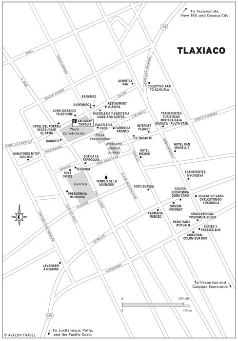
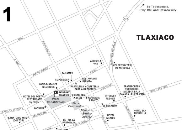
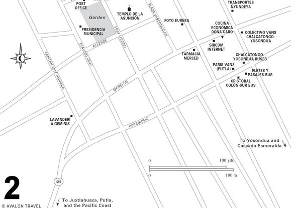
 Tlaxiaco Saturday Tianguis
Let Plaza Constitución, the hub of the Tlaxiaco market, a few blocks uphill from the cluttered and bumpy through-town highway, be your key to finding your way around town. Main east–west streets Colón and 5 de Mayo run along the north and south sides, respectively, of Plaza Constitución. East of the plaza, they intersect the other main town streets, Independencia and Hidalgo, which both run north, uphill from the highway. The perfect spot to view all of this is the front porch of the Hotel del Portal, which perches on the uphill (north) side of the plaza. From there, you’ll see the town clock in the plaza foreground, and in the background, the bell tower of the town church, Templo de la Asunción, a few hundred yards to the southwest. To the right of the church, behind some trees on the west side of a shady jardín, stands the town presidencia municipal.
Make sure to arrive in Tlaxiaco by noon on Saturday, in time to soak in its spreading, colorful, Saturday tianguis (native town market). It’s fun to just wander around beneath the rainbow of awnings shading a galaxy of merchandise, both modern and traditional. Especially interesting are the time-tested handmade goods: calabazas (gourds) cut and carved into bowls, utensils, and musical instruments; extensive assortments of forest-gathered roots, seeds, bark, dried flowers, and nuts, ready to brew into teas to relieve dozens of illnesses; traditional clothes—hand-embroidered huipiles and blusas from all over Oaxaca; canastas, tenates, petates (reed baskets, sturdy woven palm-leaf baskets, and mats); soft sombreros, not unlike famed “panama hats” also from palm; and leather cinturones (belts), bolsas (bags), purses, and billeteras (billfolds).
The big plus of all the bustle, of course, is the people, especially the native women, who really run the whole show. The men, who help transport the goods, usually stand back (and sometimes, unfortunately, get drunk) and let their spouses do the buying and selling. Perhaps the best two spots for native action are the narrow Plaza Vasconcelos, which heads downhill for a block from the southeast corner of Plaza Constitución, and the front steps of the church, a hubbub of native fruit and vegetable sellers.
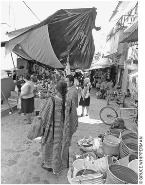
the Tlaxiaco Saturday tianguis
While you’re people-watching in front of the church, the Templo de la Asunción, take a break and step into its cool, calm interior. Although begun in 1550, the church, once a Dominican convent, has been continually modified and strengthened since that time. Towering overhead, a network of unreinforced (no steel: all stone and mortar) Gothic arches have, amazingly, supported the entire ceiling for more than 400 years, freeing the nave from the clutter of columns and creating a heavenly, soaring space for worship, rest, and contemplation.
Tlaxiaco’s patron, the Virgen de la Asunción, presides from above the altar. High above her, note the all-seeing Eye of God (which looks every bit like its counterparts that decorate many Buddhist and Hindu stupas in India and Nepal).
Townsfolk celebrate their beloved patron in a pair of annual fiestas. The first, the official patronal religious festival, Fiesta de la Virgen de la Asunción (accent on the “o” in “Asunción”), kicks off on the third Sunday in August and continues for two more days with processions, food, and fireworks. The second patronal festival begins on the third Sunday of October and includes fireworks, basketball and pelota mixteca (traditional ball game) tournaments, and popular dances.
Botica la Parroquia
Just across the street, north, from the churchfront, the Botica la Parroquia (Porfirio Diaz, at the corner of Fray Candelas, tel. 953/552-0008, 8 A.M.–9 P.M. daily) is as much a museum as a pharmacy. Its 150 years of continuous operation, begun by the present owner’s great-grandfather and handed down through the family, has resulted in a vast and venerable collection of antique bottles, flasks, urns, mortars and pestles, and a regiment of drawers stuffed with locally gathered barks, leaves, mosses, grasses, flowers, mushrooms, seeds, minerals, and animal parts for compounding into remedies to relieve a host of ailments. For example, you can get siete aguas (seven waters) for relief of mal aire (bad air), a folk name for a common ailment with symptoms of weakness and fever; often, but not always, modern doctors diagnose mal aire as malaria. You can also get catalan and arnica for aches and pains; and, for whatever else ails you, homemade herbal brandy is dispensed in two-peso portions from a gallon jug on the front counter.
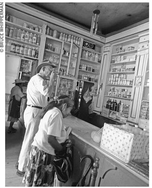
The author samples the medicinal brandy at the bar of Botica la Parroquia.
The present owner explains his pharmacy’s history and mission: “Grandad was the town doctor. Everyone came to him when they were sick. He hand-prepared all of his prescriptions. My mom still does it.”
Accommodations
UNDER $25
A block and a half west of Plaza Constitución stands the downscale old standby, the family-run Hotel Mexico (Hidalgo 13, tel. 953/552-0086, $15 s or d, $23 t “old” rooms, $25 s or d, $29 t “new” rooms). Rooms in “new” (private bath) and “old” (shared bath) sections surround a rambling inside patio. All of the 20-odd rooms are clean; the “old” rooms are plainly furnished, while the “new” are thoughtfully decorated with polished wood furnishings, attractive bedspreads, and drapes. Rooms all come with hot water, available only in the morning until 11 A.M.; credit cards are not accepted.
Located a few blocks southeast of the town center, the Hotel San Mishell’s (Independencia 11, tel. 953/552-0064, $13–21 s, $21–25 d) offers attentive on-site family management. The 20 superior-grade rooms in a two-story wing surround an inviting inner garden patio. Inside, rooms are clean, carpeted, and thoughtfully decorated. Outside the rooms, on a shady garden-view porch, guests enjoy soft chairs for reading and relaxing. Standard-grade (shared bath) rooms occupy a two-story tier beside an adjacent parking patio, and do not have TVs. All guests enjoy hot-water shower-baths, parking, and a breakfast restaurant, but credit cards are not accepted.
$25–50
Of Tlaxiaco’s hotels, the semi-deluxe  Hotel del Portal (Constitución 2, tel. 953/552-0154, $23–28 s, d one bed; $26–35 d, t two beds), at the north-side plaza-front, affords a superb vantage for soaking in the market action and exploring the colorful town center. Inside, past the reception, you enter an elegantly restored grand patio, softly illuminated by an overhead skylight. The three stories of approximately 50 rooms encircle a back parking courtyard. The rooms come in two grades, standard and semi-deluxe (invitingly decorated, with wall-to-wall carpet), and all are clean, comfortable, and well maintained, with hot-water shower-baths, TV, and parking; Visa and Mastercard are accepted.
Food
Taco stands and upstairs fondas (food stalls) at the covered Mercado Benito Juárez (one block south of the Plaza Constitución’s southeast corner) are your best source of economical meals and snacks. Furthermore, a homey sit-down comedor, the Cocina Economica Doña Caro (Morelos 13, no phone, 8 A.M.–8 P.M. Mon.–Sat., $4–5), between Independencia and Hidalgo, two blocks east and three blocks south of the plaza’s southeast corner, serves from a bountiful menu, for example, huevos rancheros and mexicanos for breakfast; and choice of either steaming chicken, turkey, or tamales smothered in mole, or savory pork and beef guisados (stews) for their all-inclusive four-course comida lunch or supper.
Basic groceries are available at plaza-front abarroterías (grocery stores), notably at Super Mega (Constitución, tel. 953/552-0179, 8:30 A.M.–9 P.M. Mon.–Sat., 8:30 A.M.–6:30 P.M. Sun.), on the plaza’s northeast side, two doors east of the Hotel del Portal.
Baked goods are also sold at several stalls at the Mercado Benito Juárez and Pastelería Flor (Cinco de Mayo, half a block east of the market plaza’s southeast corner, tel. 953/552-0555, 9 A.M.–10 P.M. daily), with a host of delights, including chocolate, three-milk, cheese, and lemon cakes, good coffee, and hamburgers, tortas, and hot dogs to boot.
A sprinkling of restaurants (some very good) cater to the trickle of visitors and handful of Tlaxiaco residents who can afford to eat out. Tlaxiaco’s fanciest is the Restaurant El Patio (Constitución 2, tel. 953/552-0154, 8 A.M.–9 P.M. daily, $4–5), in the airy inner courtyard of the Hotel del Portal. Oaxacan cuisine is the main event here; pick from a long list of appetizers, such as roasted onions with leaves of nopal or tortilla soup; for a main dish, you might choose pierna de puerco (leg of pork) smothered in rich dark mole or Tlaxiaco-style tacos.
For a leisurely comida corrida (set lunch) or a bountiful à la carte selection on a warm afternoon, go to refined, airy restaurant  El Encanto (Vásquez 6, tel. 953/552-0529, 8 A.M.–9 P.M. Mon.–Sat., $3–7, set lunch $4), a block south and a block and a half east of the main plaza’s southeast corner. Find them open also for à la carte breakfast and cena (supper).
Information and Services
Change money at Tlaxiaco’s plaza-front Banamex (Colón 1, tel. 953/552-0166 or 953/552-0133, 9 A.M.–4 P.M. Mon.–Fri., 9 A.M.–1 P.M. Sat.) with ATM.
Alternatively, go to Banorte (at the plaza’s southwest corner, tel. 953/552, 9 A.M.–5 P.M. Mon.–Fri.) for similar services and ATM.
Find the correo (tel. 953/552-2126, 9 A.M.–5:30 P.M. Mon.–Fri., 9 A.M.–1 P.M. Sat.), on the north side of the jardín in front of the church. Next door, at telecomunicaciones (tel. 953/552-0190, fax 953/552-0465, 8 A.M.–7:30 P.M. Mon.–Fri., 9 A.M.–noon Sat.), you can send or receive a fax or money order.
Telephone long distance or send a fax at the big SAM caseta larga distancia (Constitución, on the plaza’s north side, next to the Hotel del Portal, tel. 953/552-0313, 953/552-0314, or 953/552-0147, 7 A.M.–11 P.M. daily). Alternatively (and more economically), buy a commonly available Ladatel telephone card and use it to call home in the United States, Canada, or Europe ($2 for four minutes).
See MEXICAN NAMES
Answer your email and access the Internet at Internet Pl@net (on Vasconcelos, near corner of Independencia, no phone, 8 A.M.–10 P.M. Mon.–Sat., 10 A.M.–10 P.M. Sun.), two blocks west and a block south of the plaza’s southwest corner.
If you need a doctor, ask at your hotel desk for a recommendation or contact one of Tlaxiaco’s highly recommended physicians: such as Dr. Javier Noé Alavez Cervantes at Sanatorio Mitzy (Moctezuma 4, tel./fax 953/552-0058), a block and a half west from the plaza; or physician-surgeon Dr. Geraldo Cruz Vela (Aldama 6, tel. 953/552-0210).
For nonprescription medicines and drugs, try either Farmacia La Merced (corner of Morelos and Hidalgo, tel. 953/552-0483, 8 A.M.–9 P.M. Mon.–Sat., 10 A.M.–2 P.M. Sun.), downhill three blocks from the plaza, or Farmacia Pronto (Cinco de Mayo, tel. 953/552-0664, 9 A.M.–9 P.M. Mon.–Sat.), half a block east of the plaza’s southeast corner.
In police, fire, or medical emergencies call the policía municipal (tel. 953/552-1021) or hire a taxi to take you to them.
For film, development, and some digital and film point-and-shoot cameras and supplies, go to Tlaxiaco’s Fuji film dealer, Foto Eureka (Hidalgo, tel. 953/552-0249, 8 A.M.–9 P.M. Mon.–Sat., 8 A.M.–2 P.M. Sun.), two blocks south, one block east of the plaza.
Tlaxiaco’s friendly, family-owned laundry is Lavandería Geminis (Capitán José Herrera 20, tel. 953/552-0708, 8 A.M.–9 P.M. Mon.–Sat.). Find it on Herrera: from the plaza’s southwest corner, walk a block west, then three blocks south.
Getting There and Away
A welter of taxis, local buses and minivans, and long-distance buses deposit and pick up a small army of passengers daily downhill on Highway 125, locally called Avenida Hipodromo as it runs east–west along the south edge of downtown, and Independencia after it turns north and continues along the east edge of downtown.
Long-distance service includes Sur and Omnibus Cristóbal Colón, from their station (Hipodromo 24 B, tel. 953/552-0182), half a block west of the Independencia corner. There, buses connect east and southeast with Teposcolula, Yanhuitlán, Nochixtlán, and Oaxaca City; and north with Tamazulapan, Huajuapan, Puebla, Cuautla (Morelos), and Mexico City.
Also, on Hipodromo, a few doors east, second-class Fletes y Pasajes (tel. 953/552-0432) long-distance buses connect east and southeast with Teposcolula, Yanhuitlán, Nochixtlán, and Oaxaca City; and north with Mexico City (Tapo terminal) by the expressway, via Coixtlahuaca, Tepelmeme, Tehuacán, and Puebla.
Furthermore, a pair of good van services provide fast and frequent connections. On Independencia, three blocks north of Hipodromo, Transportes Turística Mixteca Baja (Independencia, tel. 953/552-0308) connects very frequently with Oaxaca City, via Teposcolula and Nochixtlán, south with Putla (where connections are available for the Pacific coast), and Yosundua (around noon and 6 P.M. daily). Alternatively, reliable RAMSA vans (Hipodromo 13), next to Omnibus Cristóbal Colón, connect frequently northeast with Oaxaca City, and south with Putla.
Drivers can connect southerly, to or from Tlaxiaco, with Putla, by Highway 125 (75 km/47 mi), in about two hours; westerly, with Juxtlahuaca via Highways 125 and 182 (80 km/50 mi), also in about two hours; and easterly with Teposcolula (42 km/26 mi), in about an hour, thence another three hours, to or from Oaxaca City.
SOUTH OF TLAXIACO
Although the glorious Cascada Esmeralda (Emerald Waterfall) at the end of the road is reason enough to venture out on this 171-kilometer (106 mi) round-trip excursion, the sights along the way make the journey doubly enjoyable. You’ll gaze at a succession of mighty pine- and oak-studded mountains, mile upon mile of green, terraced fields, and, oddly in contrast, one of the most spectacularly eroded landscapes in Oaxaca. Moreover, you’ll pass as many log cabins here than on a trip through all of Montana and Wyoming. And if you go on Sunday, you’ll get a chance to visit a pair of busy country markets. Finally, self-contained RV or tent campers can enjoy a superbly scenic natural camping site at the dramatic top of Cascada Esmeralda. The all-paved route climbs to the top of the Mixteca Alta—the 2,700-meter (9,000 ft) cool, fertile, Chalcatongo plateau—before descending to Yosundua and the subtropical Esmeralda valley, where on a clear day, folks say, you can glimpse the blue Pacific.
The Road to Chalcatongo
Start out early (8 A.M. by bus, no later than 10 A.M. by car) because in the Mixteca (Land of the Clouds), especially in the summer–fall rainy season, sunny mornings often turn gray, drizzly, and cool by mid-afternoon. By minibus, go from the Transportistas Ñundeya minibus terminal (on Independencia, half a block uphill from Hipodromo). Catch one of their morning departures to Chalcotongo and Yosundua.
Drivers, mark your odometer and head south along the southern prolongation of Independencia, from the Highway 125 Independencia-Hipodromo corner. It’s best to fill up with gasoline in town before departure (gas on east, Oaxaca City, side only). There is only one gas station en route, at Chalcatongo (although stores along the way do sell unleaded regular). If you want to eat well along the way, take your own picnic, especially during the winter, when upcountry fresh fruit and veggie supplies are at a low ebb.
At kilometer 16 (mi 10), the road reaches an overlook where you can gaze down upon the Magdalena Peñasco (Stony) valley, with erosion so dramatic that, like the scenic Badlands of Dakota, it’s a sight in itself. The reason isn’t so difficult to figure out. Long ago, the people cut the trees for fuel and houses, then farmed the hills without contour terracing. They let sheep and goats overgraze the meadows, and when downpours began forming gullies, it was too late. Today the entire valley looks like a red, rutted devil’s playground.
As you continue downhill, you’ll see folks along the road weaving palm leaves, especially on Sunday, as they walk toward the weekly Magdalena Peñasco tianguis (native town market). Passing the town square and market, at around kilometer 19 (mi 12), notice one of Magdalena’s major public buildings—a turquoise-blue log house—on the right.
Around kilometer 34 (mi 21), continuing through San Mateo Peñasco, it’s difficult not to be awed by the towering stone-faced mountain on the right. In times past (or maybe even in times present) this awesomely rugged rampart, which local people call simply La Peña (The Rock), must have been a sacred mountain, with its own Señor del Monte (Lord of the Mountain).
Today, a cross stands partway up the slope, where the villagers climb on May 3, the Día de la Santa Cruz (Day of the Holy Cross). Although arduous, the hike to the summit appears doable with effort by fit people wearing hats and sturdy shoes and carrying drinking water. Don’t attempt it, however, without permission from the San Mateo Peñasco municipal authorities, who can probably suggest a guide whom you can hire to show the way.
In contrast to the eroded Magdalena valley, the surroundings of San Pedro Molinos, at kilometer 45 (mi 28), appear the model of progressive farming practice. Lush valley-bottom fields give way to terraced, mid-slope gardens, which lead to a crown of thick summit forests. San Pedro Molinos town is marked by its spiffy, portaled presidencia municipal.
Farther on, at Santa Catarina Ticúa around kilometer 50 (mi 31), note the uniquely picturesque three-story log house, on the right just as you arrive at the town plaza and church. Next, step across the plaza and take a look inside the brilliantly painted 18th-century church, dedicated to martyr Saint Catherine. If you’re lucky, you’ll arrive on November 24 or 25, when local people are celebrating Santa Catarina with processions, fireworks, sports contests, and dances. If not, at least you can admire the Mixtec pre-Columbian floral designs on the church’s walls and ceiling, and maybe afterward, if it’s a warm day, you might pause for a dip in the community swimming pool (if it’s been maintained; it was algae-stained at my last visit) outside, next to the church.
Chalcatongo
At around kilometer 60 (mi 37), you reach high and cool, sometimes even chilly, Chalcatongo (pop. 2,000). Chalcatongo has two plazas; the first one bordered by the distinguished church, the Templo de la Natividad, whose patron, the Virgen de la Natividad, townsfolk celebrate with a fiesta on September 8. Chalcatongo is otherwise quiet except for Thursday, when a regiment of local Mixtec-speaking folks and dozens of vendors from as far as Mexico City crowd in for a big country tianguis market.
At the second plaza, one block ahead, one block left, stands the presidencia municipal. Although the plazas have a few taco shops, only a few places in town serve complete, country-style meals. The best are the immaculate Restaurant El Paisano and the Restaurant El Fortín, both on the north (Tlaxiaco) side of town where, entering town from Tlaxiaco, the truck route bypass forks right. El Fortín is on the right, just before the fork.
 El Paisano (around the corner, just past the Hotel 2000, 7 A.M.–8 P.M. daily, $2–3) serves hearty breakfasts (huevos a la Mexicana, pancakes, chilaquiles and eggs) until noon, and a filling comida (pork in red mole, chiles rellenos in tomato sauce) until 5 P.M., and supper choices of tacos, quesadillas, eggs, and tortas until closing. El Fortín, also highly recommended locally, has similar hours and food, as does a the third restaurant choice, El Calvario (corner of Guerrero and Insurgentes, 2nd floor), on the south side, on the highway out of town.
If you decide to stay overnight, Chalcatongo has a good family-run hotel, the  Hotel Lazo (Cinco de Mayo 67, tel. 953/533-4061, $10 s, $17 d in one bed, $24 d in two beds, $30 t), in the south-side neighborhood. The hotel, built around an inviting interior patio courtyard, offers 24 very clean, comfortable (but smallish) rooms, with 1–3 beds and private hot-water shower-baths.
Yosundua and Cascada Esmeralda
Drivers lucky enough to arrive in Yosundua (at km 82/mi 51) on Sunday will probably find the way to the waterfall blocked by the big, colorful tianguis (native town market). Stroll around for a while, then detour downhill, then ahead, via the street that runs in front of the big church, Templo Santiago Apóstol. The church is dedicated to Saint James the Apostle, whom townsfolk celebrate July 23–26. Bus passengers should either hire a taxi or hike straight ahead from the Yosundua bus stop about 4 kilometers (2.5 mi) and 300 meters (1,000 ft) downhill to the Cascada Esmeralda.
If you’re hungry, stop by the clean, family-run, home-style Restaurant Manantial (Restaurant Spring; 8 A.M.–9 P.M. daily, $2–8), named for the town’s crystal-clear water source, nearby. It’s at the far, southeast edge of town, where the gravel road heads south to the Cascada Esmeralda.
If you miss the last bus back, you can stay at the basic but serviceable Hotel California (no phone, $12 s or d one bed, $18 d in two beds), whose personable owner returned from California with a wad of cash and decided to build himself a hotel. He now has 31 mostly empty, spare but clean rooms, with private hot-water shower-baths. You can’t miss the place, because, except for the church, it’s the biggest building (downhill two blocks on the right as you enter) in town.
Another overnight option, for people who are equipped, is to set up a tent or park their self-contained RV in the informal meadow campground at the top of the Cascada Esmeralda, at kilometer 85 (mi 53). There, the blue-green (brown during the summer rains, however) Río Esmeralda pauses a while in an inviting pool (safe only at low water) before it plunges over the cliff. The road winds another few hundred yards down a steep grade; continue on foot down a steep, short path to the foot of the falls, where you’re surrounded by natural beauty. On one side, the waterfall, split into a lacy network of petite cascades, cools you with gentle spray, while on the other, far below, a grand, sun-dappled verdant valley of field and forest nestles beneath a host of sharp, soaring peaks.
EAST OF TLAXIACO
The country east of Tlaxiaco undulates over small fertile vales and green pine-forested hilltops, many crowned with the ruins of ancient buried towns and cities. Two of the largest and most interesting of those ruins are at Achiutla and Huamelulpan, not far from Tlaxiaco.
San Miguel Achiutla
The archaeological site at Achiutla (ah-shee-YOO-tlah, pop. 1,000) stands among Oaxaca’s historically most intriguing, partly because it contains both pre- and post-conquest ruins. These include the remains of the earthquake-collapsed original Dominican church and a grand pre-conquest ruined complex, once the site of a renowned 15th-century Mixtec oracle.
GETTING THERE
The gorgeous pine-forested mountains and lush (summer–fall rainy season) valleys you pass along the way are part of the fun of Achiutla. Bus travelers go most conveniently by the minibuses that leave for Achiutla (via Santa Caterina Tayata) from the corner of Calle 5 de Mayo and Highway 125 (Av. Independencia) at the northeast corner of downtown Tlaxiaco. Alternatively, bargain for a taxi to take you to the Achiutla turnoff (signed Santa Catarina Tayata) about 14 kilometers (nine mi) east of town, then catch a truck from there. If so, find out the price—ask, “¿Cuanto cuesta a Achiutla?” (“How much to Achiutla?”)—before getting on.
For drivers, the road is broad and paved all the way to Achiutla. From Tlaxiaco, along Highway 125, drive east about 14 kilometers (nine mi); or west from Teposcolula about 27 kilometers (17 mi). Set your odometer at the signed Santa Catarina Tayata turnoff. After 1.9 kilometers (1.2 mi), bear left at the fork, and continue through Santa Catarina Tayata (8.4 km/5.2 mi) and follow the left fork (8.7 km/5.4 mi). At 10.3 kilometers (6.4 mi) pass over Río Tayata (Puente Sabino) bridge, above the idyllic grove of ancient ahuehuete (sabino) (bald cypress) trees. Some of the gnarled giants, three meters in diameter, must be at least a thousand years old. The adjacent creekside meadows provide good informal camping. (Bring water.) First, however, get permission (which is usually no problem) from the municipal authorities at Santa Catarina Tayata.
At kilometer 17 (mi 10.5) you get the first glimpse of the old San Miguel Achiutla church on the hill straight ahead. Pass over another Puente Sabino bridge at kilometer 18 (mi 11) and continue straight ahead for the old church on the right, ruins on left (20.3 km/12.6 mi). San Miguel Achiutla village is a mile and a half farther, at 22.5 kilometers (14 mi).
EXPLORING THE SITE
The area of historical and archaeological interest lies on an airy, scenic hilltop west of the existing antique church. Christened the Templo de San Miguel Achiutla, the baroque (circa 1700) ex-convent stands on the rise to the south of the road. It supplanted an even older church, now in ruins, on the other side of the road, probably built atop the pre-conquest oracle temple. Beyond that rises a cemetery occupying what appear to be three pre-conquest ceremonial plazas cut, like grand stair steps, into a mountainside that stretches another 1.6 kilometers (one mi) to a high, breezy summit.
First, however, walk south across the broad atrium that leads to the present church. On your way, take a look at the pair of ponderous bronze bells, dated 1848, hanging from the rustic ground-level campanario (“bell tower”). The Dominicans built the church probably during the late 1600s, after the original across the road (that was begun in 1558) was destroyed by an earthquake. The new church, dedicated to Archangel St. Michael, grew into a prosperous vicarage, surrounded by a cluster of dependent congregations. Times changed, however. The once-new church is now crumbling and nearly abandoned. Its doors open regularly only for Sunday mass at 10 A.M., after which folks lock up and return downhill for an 11 A.M. mass at the church in town.
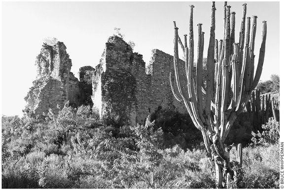
the original 1558 Achiutla church, now in ruins
A major exception occurs during festivals, celebrating the Sacred Heart of Jesus (June 19), Carnaval (Sun., Mon., and Tues. before Ash Wednesday), and especially the Fiesta de San Miguel (Sept. 21–29), when masses fill the old church every day.
At this writing, a combined federal-state effort is restoring the old ex-convent section as a museum, similar to what they did at Yanhuitlán. In the future, a museum volunteer might be available to show you around inside the old church.
For the present, the old place is certainly well worth finding the sacristan (church-keeper, often nearby) who might open the door for you.
If so, you’ll see the inside completely unrestored except for the gilded, baroque main altarpiece, recently refurbished after it collapsed under its own weight. In addition to the native artists’ colorful floral designs, the nave walls hold a gallery of precious 16th-century paintings. Don’t miss the one showing the angel St. Michael leading a mortal into heaven. Up front, bats flit and flutter out of the baptismal chapel on the left. On the opposite side, note the unusual screened platform high on the south wall, said to have accommodated cloistered nuns who nevertheless wanted to view mass in the nave. The door on the nave’s right front leads to an open courtyard, which in turn leads to the ex-convent’s former working and living quarters.
Outside, across the road, the crumbling ruin of the original church stands atop the once-famous Achiutla oracle temple. This spot abounds with legends. A Mixtec codex records that one Tilantongo queen was born from a tree in Achiutla. So powerful was Achiutla’s magic that people came, believing it to be the home of an all-seeing spirit, an oracle, known then as the Corazón del Pueblo (Heart of the People), who, acting through the local priests, could portend future events. When Cortés threatened his capital, no less than the Emperor Moctezuma sent emissaries to Achiutla. They asked that proper sacrifices be made to the oracle in return for a divination of the result of Cortés’s threat. The answer was that Moctezuma’s grand empire would be destroyed.
Past the ruined church, climb along paths through the ancient retaining walls, built by long-dead Mixtec masons, to the cemetery’s upper levels. Gaze out toward the fertile Achiutla valley far below, encircled by a verdant crown of pine-capped mountains.
Nearby, scattered around you, the cemetery’s oldest legible tombstones date from around 1900; many others, unreadably weathered and crumbling, appear much older. Buried beneath those—no one yet knows how deep or old—lie the relics of Achiutla’s past.
San Martín Huamelulpan
The community museum at Huamelulpan (oo-wah-may-LOOL-pahn), about two kilometers (1.2 mi) off Highway 125, five kilometers (three mi) east of the Achiutla turnoff, was built partly to display the artifacts uncovered at the town’s important archaeological zone. The National Archaeology and History Institute (INAH) installed the museum’s archaeological exhibits in 1978. Later, the local community took over and did its own oral history project during the late 1980s, which resulted in the museum’s traditional medicine displays.
See DUENDES: SPIRITS OF MEXICO
Note the sign on the post on the right as you reach the town plaza. It reads, roughly: “Please stop and register at the community museum and get a guide to show you the ruins.” If you arrive when the museum is closed, ask around for someone to guide you.
Huamelulpan Museum and Archaeological Zone
The museum is officially called the Museo Comunitario Ihitalulu (ee-ee-tah-LOO-loo; no phone, 10 A.M.–5 P.M. Tues.–Sun.), meaning “Beautiful Flower.” Inside, on the left after you enter, you’ll see the archaeological section first, with its especially notable monolith of Dzahui, the Mixtec god of rain, lightning, and thunder (akin to the Zapotec god Cocijo). Also fascinating are burial remains, including a complete skeleton and bowls for portions of water, food, and pulque (alcoholic beverage) for the afterlife. On the museum’s opposite side, find the equally intriguing traditional medicine exhibit, detailing methods that curanderos (curers), yerberas (herbal healers), and parteras (midwives) use to treat their clients. Conditions commonly treated include el parto (childbirth), el empacho (stomach infections), mal aire (shivering, and head and body aches; sometimes diagnosed as malaria), and el espanto (soul loss, accompanied by severe anxiety). Displays illustrate many remedies, from herbal teas and temazcal hot baths to doses of chicken blood and incantations beseeching forgiveness from earth spirits.
EXPLORING THE ZONE
Leave time for a stroll around the archaeological zone. It was first visited in 1933 by Alfonso Caso of Monte Albán fame, and it has been intensively excavated and partly reconstructed by several others since the 1950s. Finds reveal that Huamelulpan was a small city occupied between 400 B.C. and A.D. 600, approximately the same epoch as Monte Albán.
The zone rambles extensively over many hundreds of acres, running north of town along an approximate east–west line. The most westerly discovered (but unreconstructed) remains lie on the high west-side Cerro Volado hilltop. The most intensively reconstructed portion is the so-called Church Group, near the church, a few hundred yards east beyond the town plaza and museum.
Start at the church itself, which has what appears to be a grinning pre-conquest god of death skeleton-monolith built into its right (south) wall. If you continue walking south along the road in front of the church, you will be passing the partly reconstructed ball court, reachable by ascending the rise to the left (east) of the road. Notice, at the ball court’s south end, the reconstructed half of its I-shaped layout. Continue east, up the second embankment, to a regal ceremonial courtyard climaxed on its east side with an elegant staircase and retaining walls. Climb those stairs to another level and yet another courtyard crowned by an equally elegant but smaller ceremonial platform.
Huamelulpan community museum volunteers lead visitors on tours of their archaeological zone, including Cerro Volado, for a fee of about $20. Arrive early and you may be able to arrange such a tour on the spot. Guides and lodging at Huamelulpan’s tourist-house dormitory can also be reserved ahead of time by leaving a message, including time of arrival and number in your party, at the Huamelulpan long-distance telephone caseta (tel. 555/510-4949).
Get to Huamelulpan by car or Tlaxiaco-bound second-class Omnibus Cristóbal Colón Sur, Fletes y Pasajes, or van from Oaxaca City, Nochixtlán, Tamazulapan, or Teposcolula. Get off at the Huamelulpan turnoff on Highway 125, about half an hour (21 km/13 mi) past Teposcolula. In the reverse direction, drive or ride the same bus and van east from Tlaxiaco a similar 21 kilometers (13 mi), half an hour, and get off at the Huamelulpan side-road turnoff. Continue on foot, or by taxi, about two kilometers (1.2 mi) to the museum on the town plaza.
WEST OF TLAXIACO
This is high, cool country of pine-brushed mountains, villages, and cornfields. The people are reserved but quick to return your wave and smile. They see so few outsiders that, although they try to avoid it, they can’t help staring as you pass, wondering why you’ve come. For at least two of these communities, Santa María Cuquila and San Miguel Progreso, visitors have an immediate reason for coming: to see the community museums.
Santa María Cuquila
The Aztecs, to whom the Cuquila (koo-KEE-LAH) people were tributaries at the time of the conquest, coined the name Cuquila, which roughly translates to Snakes in the Brush. The Mixtec-speaking local people, however, previously called their village Ñu Kuiñe, which means “Town of the Tiger” in the local tongue.
Now, Cuquila (pop. 2,000) with the help of the government Centro de Desarollo Para los Pueblos Indígenas (www.cedei.gob.mx/cuquila) has organized a museum with a number of historic artifacts, including hieroglyphinscribed stones found in the big archaeological zone nearby, and documents from the 1580s, such as a map of the town and several yellowed pages recording a plethora of information—town borders, officials’ names, events, and perhaps even a little gossip—of early colonial days in Cuquila. The museum also displays examples of locally made present-day pottery and hand-woven huipiles.
The town presently runs a handicrafts store, built with the help of the American-based Amigos de las Americas (www.amigoslink.org), on the highway through town. This would be a good spot to stop and maybe see the artesanos—potters and weavers—at work, and/or make contacts to visit their home workshops in the village.
The museum committee is currently headed by its president, at this writing, Mario Hilario Baldamero. He and other committee members are qualified to take you on a tour (about three km/two mi, three hours round-trip, offer a donation of about $20) to their “old town” (former population of 3,000) archaeological site on a hill nearby.
Archaeologists reckon that the site was occupied for about 1,300 years, from 400 B.C. to A.D. 900. The ceremonial area, consisting of the remains of a pair of royal residences, a main plaza, two tombs, and a ball court, spreads over about 25 acres. The Cuquila museum is open by appointment, which you can make, or better yet, ask your hotel desk clerk to make by calling the town long-distance telephone (tel. 953/554-0716) or the town agencia municipal (tel. 953/596-3398 and 953/596-3399).
Although at this writing they have no guest cabañas, they’ve started a comedor (tel. 953/596-3302, 9 A.M.–5 P.M.) at their handicrafts shop.
Get to Cuquila by local van, or Fletes y Pasajes or Sur bus from Juxtlahuaca, Tlaxiaco, or Putla. By car, Cuquila is right on Highway 125, 19 kilometers (12 mi) west of Tlaxiaco, 56 kilometers (35 mi) east of Juxtlahuaca, or 51 kilometers (32 mi) northeast of Putla.
San Miguel Progreso
Three kilometers (two mi) downhill from its signed entry road from Highway 125, San Miguel Progreso (pop. 3,000) welcomes visitors to its museum. The museum committee has arranged the museum displays in four different sections. First are the historic papers, such as a 1780 document defining the town limits and a copy of a 1580 lienzo that maps the location of buildings, roads, rivers, and town boundaries. Next comes an excellent exposition of the local wool-weaving craft, then a mock-up of a typical indigenous dwelling. An archaeological section demonstrates finds, such as stone ax blades, ceramic vases, lance points, and human burial remains, including grave offerings. A final display models the pre-conquest method of terraced agriculture.
The local area contains a number of interesting sites, enough for a whole day of exploring. These include three unexcavated archaeological zones: Lomatutaya (Where the People Rest), Tuxau (Fifteen Words), and Panteón de los Angelitos (Cemetery of the Little Angels). Also nearby are two sacred caves, where masses are celebrated on May 3, El Día de la Santa Cruz (The Day of the Holy Cross).
Time your arrival on the locally important festival dates, September 29 (Fiesta de San Miguel) or the fifth Friday of Lent (Fiesta de las Tres Caidas de Jesús), when you can get in on the fun of fireworks, food, dancing, processions, music, flowers, and carnival diversions.
To make sure that one of the museum committee members is available to show you the museum and perhaps lead you on a tour, make an appointment (or best ask your hotel desk clerk to make the appointment) through the agente municipal (José Cruz Ramírez, tel. 953/556-4635).
Get to San Miguel Progreso by bus or car as described for Cuquila, except that the signed side road (off of Hwy. 125) to San Miguel is about six kilometers (four mi) past Cuquila (from Tlaxiaco) and a corresponding distance closer to Juxtlahuaca and Putla. Continue about three kilometers (two mi) along the downhill side road to San Miguel.
PUTLA DE GUERRERO: LAND OF WATER
After a week traveling in the cool, high Mixteca Alta, the rush of balmy moist tropical air you enjoy when entering the upland valley of Putla de Guerrero (pop. 15,000) feels like another country. Banana trees overhang the road; mangos, in season, sell for a dime apiece; the aroma of roasting coffee scents the air; and people fill their afternoons by splashing in their favorite local swimming holes.
You might want to linger a day or two and bask in the warmth. If so, Putla’s colorful market and its modicum of hotels, restaurants, and services can help make your visit interesting and comfortable.
Sights
The town centers on a leafy jardín, about four blocks west, downhill from Highway 125. The jardín, bordered by the presidencia municipal on the south, a line of shops on the north, and the church, at its northwest corner, focuses community activity.
The colorful, bustling market, busiest on Sunday, is a block behind the presidencia municipal. Here you’ll find stalls offering the handmade textiles—huipiles, rebozos (shawls), blusas, and enredos (wraparound skirts)—for which Putla is well known. Materials vary from wool, homespun and woven by highland Trique women, to cottons, hand-embroidered by coastal Mixtecs.
Accommodations
A relaxing hotel choice in Putla is the Hotel Beyafrey (Guerrero 9, tel. 953/553-0294, $15 s, $19 d, $25 t), about three blocks south and two blocks west of the plaza. It has a big blue pool-patio, but is somewhat unkempt. The approximately 30 high-ceilinged rooms come with toilets and hot-water showers, fan, cable TV, and parking. Ask for a room in the quiet rear section upstairs, away from the busy street-front and the trucks that use their parking lot. (Also make sure the room is clean enough and everything works before you move in.)
Another better-managed, but not so laid-back hotel, convenient for bus passengers, is the newish Hotel Plaza (Morelos 15, tel. 953/553-0403, $15 s, $18 d in one bed, $22 s, d in two beds, $26 t), on the east side of town half a block below the highway. The hotel’s 28 rooms surround an attractively leafy rear patio; uppers open to an inviting balcony walkway that leads to an airy street-view porch up front. (The only drawback is that room windows face the balcony, and curtains must be drawn for privacy, which renders the rooms dark.) Inside, guests enjoy attractive color-coordinated pink-white decor and shiny hot-water shower-baths, cable TV, and wireless Internet.
Food
You can find plenty of luscious fruits and vegetables and many inexpensive local-variety meals in fondas (food stalls) in and around the market. For groceries, try the Abarrotería Mary Carmen (at the southwest plaza corner, tel. 953/553-0228, 7 A.M.–8 P.M. daily) across the street from the presidencia municipal. For a larger selection, go to the chain grocery Super Mega (uphill a block, at the northwest plaza corner, tel. 953/553-0398, 7 A.M.–8 P.M. daily).
For restaurants, start with the choices on the highway. Most inviting is Restaurant Tito’s (next to the Omnibus Cristóbal Colón terminal, tel. 953/553-1065, 8 A.M.–9 P.M. daily, $4–12), decorated with a gallery of paintings of sentimental old-time Putla scenes, and an airy terrace with a view, especially pleasant for lunch or sunset supper. You also might say a good word to the friendly travel agent–owner Tito Chaves, who’s proud of his eclectic menu of salads, pasta, beef brochette, chicken fajita, and seafood (shrimp, fish, octopus).
Also on the highway, next door, downhill from Tito’s, you can choose the clean family-run comedor-style Abarrotes-Restaurant Velasco (tel. 953/553-0047 or 953/553-0099, 8 A.M.–9 P.M. daily, $2–8) for breakfast, lunch, and supper.
Downhill, near the plaza, is what seems to be Putla’s most popular local-style eatery, Sabor de Mi Tierra (Flavor of My Land; corner of Queretaro and Sonora, local cell tel. 044-953/113-4754, 8 A.M.–8 P.M. daily, $4–7), behind the church. Here, in a no-frills, but immaculate dining room, choose from a long, intriguing, all-local menu: eggs your choice, entomatado, carne enchilada, and tasajo for breakfast; chiles rellenos, barbequed pork ribs, pork chop or meat balls in spicy sauce, and baked chicken under black mole for comida or supper.
Entertainment and Events
Ordinarily quiet Putla livens up during its regionally important fiestas. Carnaval Putleco, celebrated on the Sunday, Monday, and Tuesday before miércoles ceniza (Ash Wednesday), is rich in traditional dances. Local favorites, nearly always performed, are Los Viejos (The Old Ones), El Macho, and Los Copala.
Later in the year, folks crowd the churchfront atrium for the Fiesta de la Natividad, which kicks off on September 6 with a grand calenda and flower-decorated floats, continues with a feast of fireworks on September 7, and culminates on the following day with peleas de gallo (cockfights), jaripeo, and a big community dance.
Other times, Putla people cool off from the heat by frolicking in the mountain rivers that flow past the town. Join in the fun on a hot afternoon by asking a taxi driver to take you to a balneario (bathing spot); one of the best is the Río Cucharra swimming hole, with restaurant and riverview picnic area, about three kilometers (two mi) along Highway 125, uphill from town.
Information and Services
You’ll find nearly all of Putla’s basic services near the town jardín. Change money or use the ATM at Bancomer (tel. 953/553-0028, 8:30 A.M.–4 P.M. Mon.–Fri., 10 A.M.–3 P.M. Sat.), a block north from the jardín’s west side, across from the basketball court. Alternatively, go to Banamex (Calle Oaxaca, 9 A.M.–4 P.M. Mon.–Fri.); from the southeast jardín corner, walk two blocks east, then south (right) two blocks.
The Putla correo (tel. 953/553-1484, 8 A.M.–4:30 P.M. Mon.–Fri., 8 A.M.–noon Sat.) is across from the northwest corner of the basketball court, a block above the jardín, right next to telecomunicaciones (tel. 953/553-0999, 9 A.M.–3 P.M. Mon.–Fri., 9 A.M.–noon Sat.).
Long-distance phone and fax are available at the caseta (tel./fax 953/553-0030, 8 A.M.–8 P.M. daily) on the jardín’s north side.
Answer your email at Paquirre Internet (tel. 953/553-0222, 9 A.M.–10 P.M. daily), at the southwest corner of the basketball court.
For telephones, use the street phones with a Ladatel card, or go to caseta Solivert (also by the plaza, tel. 953/553-0222, 9 A.M.–9:30 P.M. daily).
For routine nonprescription medicines and drugs, go to the Farmacia Ahorro (on the jardín’s west side, 7 A.M.–10 P.M. daily). If you’re ill, however, ask at your hotel desk for a doctor or go to see Doctora Silvia Zarate at her Farmacia Popular (at the jardín’s northeast corner, tel. 953/553-0252, 8 A.M.–2 P.M. and 4–8 P.M. daily). Medical consultations are also available at the General Hospital (tel. 953/553-0046), a block north of the jardín’s east side, across the street from the basketball court.
In police emergencies, call the policía municipal (tel. 953/553-0111).
For information and travel services go to Agencia de Viajes Tito (tel. 953/553-1065) of friendly Tito Chaves Garcia, on the highway next to Omnibus Cristóbal Colón bus station (which Tito also manages).
Getting There and Away
A few long-distance bus lines and vans operate from stations on or near the highway and connect Putla with many Oaxaca destinations. First-class Omnibus Cristóbal Colón (Hwy. 125, tel. 953/553-0163) connects south (one departure per day) with Pinotepa Nacional; north with Mexico City, via Huajuapan; and east, with Oaxaca via Tlaxiaco, Teposcolula, and Nochixtlán. Second-class Sur (at Sonora 34A, downtown near the Hotel Beyafrey, tel. 953/553-0350) offers both Mexico City connections via Huajuapan and Puebla and Oaxaca City connections via Tlaxiaco and Nochixtlán. Additionally, second-class Boquerón buses from a small terminal downhill from Omnibus Cristóbal Colón connect south with Pinotepa Nacional and north by the scenic backcountry Juxtlahuaca, Tonalá route to Huajuapan.
Also, from neighboring stations on Highway 125, a pair of van services provide connections with Oaxaca via Tlaxiaco; they are Transportes Turística Mixteca Baja (uphill from Omnibus Cristóbal Colón, tel. 953/553-0847), and RAMSA vans (cell tel. 953/117-6193).
For drivers, paved Highway 125 connects Putla south with Pinotepa Nacional, on the Pacific coast via 128 kilometers (80 mi) of winding, sometimes potholed, mountain road. Allow three hours for safety. In the opposite direction, Highway 125 and Highway 182 connect Putla north with Juxtlahuaca in about 59 kilometers (37 mi). Winding and sometimes steep grades require slow going. Allow 1.5 hours uphill, 1 hour downhill. About the same is true for the 77-kilometer (48 mi) connection northeast, along Highway 125, with Tlaxiaco, which, for safety, requires about 2 hours uphill, 1.5 hours down.
THE LEGEND OF THE FLECHA DEL SOL (ARROW OF THE SUN)
Once upon a time, the Mixtec warrior chief Yaconooy arrived with his soldiers in present-day Valley of Nochixtlán, looking for land for his people to settle and grow their crops. He found the place deserted, except for a brilliant sun in the sky overhead. Spoiling for a fight, but with no one to battle, Yaconooy shot an arrow at the sun, and wounded it. The Sun’s blood colored the horizon, the clouds, and the sky. With this victory over the sun, Yaconooy founded his dynasty, which prospered from his capital, the regal but now-ruined city atop Monte Negro, the Black Mountain, near the modern town of Tilantongo.
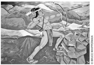
The fresco at Tilantongo City Hall illustrates how the Mixtecs came to settle in the present territory of Oaxaca.
COHETES: BANGS, FLASHES, AND HISSES IN THE NIGHT
Like everyone, Mexicans love celebrations, and every one of them, humble or grand, must be accompanied by cohetes. Although cohetes literally means “rockets,” folks always associate them with the myriad other booming, flaring, whooshing, banging, and whirling incendiary devices that traditionally go along with cohetes. And while in most of the United States, bland “Safe and Sane” fireworks are all that ordinary folks set off on the Fourth of July and maybe New Year’s, the sky seems to be the only limit during the seemingly innumerable fiestas that Mexicans celebrate everywhere.
One big climax of celebrating peaks during the several weeks before Easter Sunday, when folks start out with a rip-roaring Carnaval (Mardi Gras) and parade the six succeeding Friday afternoons to the cannonades of cohetes de trueno (thunder rockets) overhead, and end up with a grand explosive bash on Easter Sunday.
Whatever the occasion, the coheteros (rocketeers) have plenty of tricks up their sleeves, from the familiar, colorfully brilliant cohetes de luces (rockets of lights) to a dozen other strictly Mexican varieties. These include toritos, a bull-shaped frame, decorated with papier mâché and loaded with flares and firecrackers, that some daredevil wheels or carries on his back through the crowds of merrymakers.
Sometime after that, someone usually scatters some buscapies (heel-chasers) that go whizzing, whirling, and shrieking under the feet of the crowd.
Finally, the cohetero lights up the castillo, a grand framework laced with pinwheels, flares, and smoke bombs, from which a spinning corona finally swishes skyward, scattering a trail of stars in the inky firmament overhead.
EASTER CALENDAR
Although Christian religious denominations’ Easter calendars vary, virtually all Western Christian churches follow the same calendar as the Roman Catholic version, universally used in Mexico. This calendar originated with the Council of Nicaea, which, in A.D. 325, set Easter as the first Sunday after the first full moon of spring (or, more precisely, the first full moon after the vernal equinox, which the church authorities fixed as March 21).
The Easter season customarily kicks off with Carnaval, a rip-roaring party that runs the few days preceding Miercoles de Ceniza (Ash Wednesday), when all merriment ceases. Ash Wednesday, in turn fixed as the 46th day before Easter Sunday, occurs most often in February, and marks the beginning of Lent, a period of penitence and fasting. The gravity of Lent is literally rubbed in via ashes that the faithful get smeared onto their foreheads during solemn Ash Wednesday Christian church ceremonies worldwide.
In Mexico, religious processions and sober observances continue on each of the subsequent six Fridays. Domingo de Ramos (Palm Sunday) immediately follows the fifth Friday, and finally, after the sixth, or Viernes Santa (Good Friday), Domingo Gloria (Easter Sunday) breaks the fast of Lent as folks celebrate the risen Christ with joy and feasting.
MEXICAN NAMES
Nearly every Mexican, from native country folks to pure Spanish bluebloods, goes by his or her Spanish-origin names. Outsiders, confounded by long handles, such as Doña Juana María López de Díaz, wonder how Mexican names got so complicated.
The preceding “Doña Juana” example is especially complicated, because it’s a typical woman’s name, which is generally more complex than that of a typical man.
So, let’s explain a man’s name first. Take the national hero, Vicente Ramón Guerrero Saldaña. Vicente is his first given name; Ramón, the second given name, corresponds to the “middle” name in the United States. The third, Guerrero, is customarily the father’s first surname; and the last, Saldaña, his mother’s first surname. Only on formal occasions are men referred to with all four of their names. Simply, “Vicente Guerrero” would do most of the time.
Now, back to “Doña Juana.” I threw a curve at you by introducing “Doña.” It’s an honorific, used as “Dame,” for a distinguished woman. (“Don” is the corresponding honorific for Spanish men.)
So, skipping the honorific, women’s names start out like men’s: First given name, Juana; second given name, María; and father’s first surname, López.
Now, things get more complicated. For unmarried women, the naming is the same as for men. But when a woman gets married, she customarily replaces her second surname with her husband’s first surname, preceded by “de,” meaning “of.” So, in the example, Juana is evidently a married woman, who has substituted “de Díaz” (her husband’s first surname being Díaz) for her second surname, all adding up to Juana María López de Díaz.
Thankfully, however, informal names for women also are simplified. Juana, above, would ordinarily shorten her name down to her first given name followed by her husband’s first surname: simply Juana Díaz.
All the above notwithstanding, many Mexican women do not go along with this male-dominated system at all and simply use their maiden names as they were known before they were married.
DUENDES: SPIRITS OF MEXICO
Once upon a time, most everyone believed that the world was full of spirits that inhabited every object in creation: trees, rocks, animals, mountains, even the wind and the stars. World mythology is replete with examples, from the leprechauns of Ireland and the fairies of Mount Tirich Mir in Pakistan to the spirits who haunt old Hawaiian heiaus (temples) and the duendes of Mexico.
Such beliefs persist, especially in the Mixteca countryside. Eventually, many a campesino will take his children to his mountainside cornfield to introduce them to the duendes, the elfin beings who folks sometimes glimpse in the shadowed thickets where they hide from mortals.
At the upper end of his field, the campesino father addresses the duendes: “With your permission we clear your brush and use your water because it is necessary to nourish our corn and beans. Please allow us, for otherwise, we would starve.”
Modernized city Mexicans, generations removed from country village life, often scoff at such antique beliefs. That is, until the family doctor fails to cure their weakened spouse or sick child. Then they often run to a curandero or curandera (folk healer).
“Enduendado,” affliction by an angry duende, the curandero sometimes diagnoses. Often, the cure is simple and savvy: teas and poultices of forest-gathered herbs. Other times, it is mystical, such as “purifying” by passing an egg all over the afflicted one’s body to draw out the illness, and then breaking the egg into a bowl. The shape the broken yolk takes, maybe of a snake, might determine the treatment, which may be long and intricate: massage with lotions of herbs and oils, followed by a temazcal (sweat bath) rubdown with rough maguey fibers, all consummated by intense prayers to the Virgin of Guadalupe to force the duende to cease the affliction.
Many times, the folk cure fails; other times, however, it succeeds, and with enough frequency to convince millions of Mexicans of the power of the village folk healer to purge a duende’s poisonous spell.