HIKING JOHNSON CANYON-SKUTUMPAH ROAD
HIKING IN PARIA CANYON AND VERMILION CLIFFS
CORAL PINK SAND DUNES STATE PARK
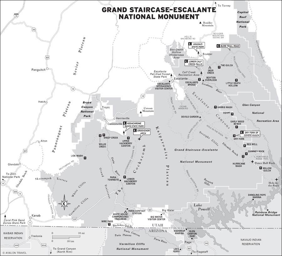
The 1.9-million-acre Grand Staircase-Escalante National Monument (GSENM) contains a vast and wonderfully scenic collection of slickrock canyon lands and desert, prehistoric village sites, Old West ranch land, arid plateaus, and miles of back roads linking stone arches, mesas, and abstract rock formations. The monument even preserves a historic movie set (think vintage Westerns).
The monument contains essentially three separate districts: On the eastern third are the narrow wilderness canyons of the Escalante River and its tributaries. In the center of the monument is a vast swath of arid rangeland and canyons called the Kaiparowits Plateau, with few developed destinations. The western third of the monument edges up against the Gray, White, and Pink Cliffs of the Grand Staircase. These thinly treed uplands are laced with former Forest Service roads. The GSENM is the largest land grouping designated as a national monument in the Lower 48.
There’s little dispute that the Escalante canyons are the primary reason people visit the monument. The river and its tributaries cut deep and winding slot canyons through massive slickrock formations, and hiking these canyon bottoms is an extremely popular adventure. A multiday trek is a rite of passage for many devoted hikers, but you don’t have to be a hardened backcountry trekker to enjoy this landscape: Two backcountry roads wind through the area, and some day hikes are possible.
M Kodachrome Basin State Park: Strange-looking rock pillars or “sand pipes” are the attraction at this state park on the edge of the Grand Staircase-Escalante National Monument. Hiking trails and a campground make this a good base for exploring Cottonwood Canyon Road south into the monument (click here).
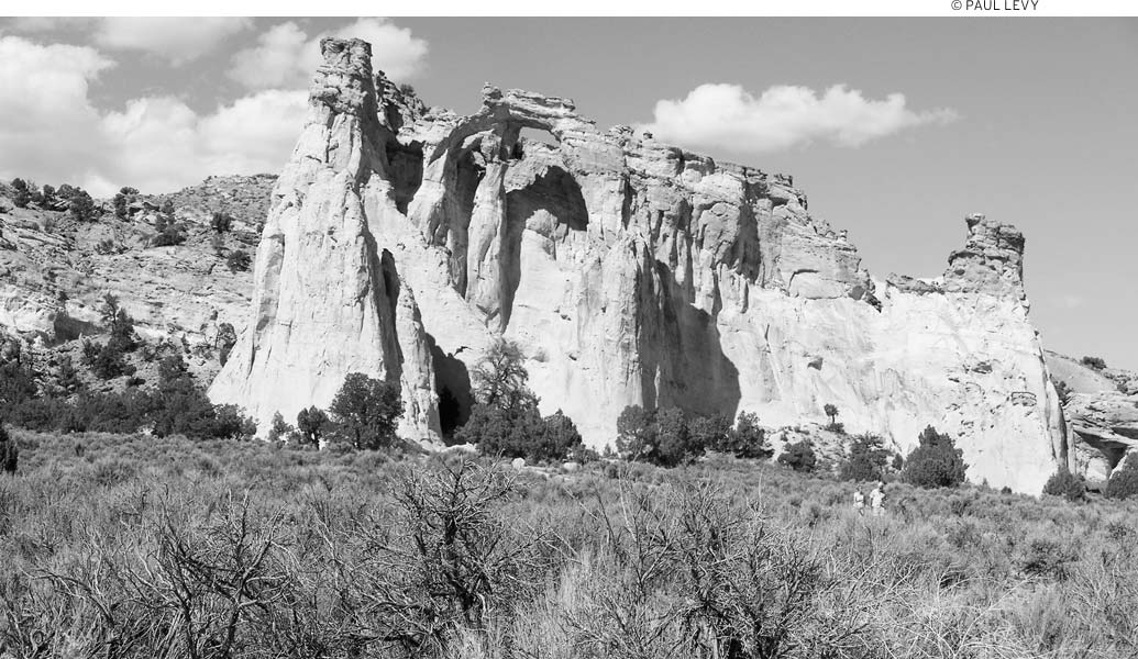
M Grosvenor Arch: In a remote yet drivable location off Cottonwood Canyon Road is the magnificent Grosvenor Arch, which is actually two sandstone arches. Photographers, including those from a National Geographic expedition in the 1940s, have continually been drawn to it (click here).
M Anasazi State Park: In addition to the good indoor exhibits at this park’s museum, there’s an excavated Anasazi village out back displaying a wide range of Anasazi building styles. This is an excellent opportunity to learn about the Anasazi (click here).
M Burr Trail Road: From its start in Boulder, through the astounding Long Canyon, to views of the Waterpocket Fold, the Circle Cliffs, and distant mountains, Burr Trail Road is a treat to drive. Don’t expect a fast trip; if the weather has been wet, inquire about the condition of the unpaved section (click here).
M Lower Calf Creek Falls: Easy enough for families, accessible with a regular car, and offering a different highlight every 0.5 miles or so, this hike is definitely worth taking. Expect to see desert varnish, beaver ponds, Native American ruins, pictographs, and the misty 126-foot-high Lower Calf Creek Falls (click here).
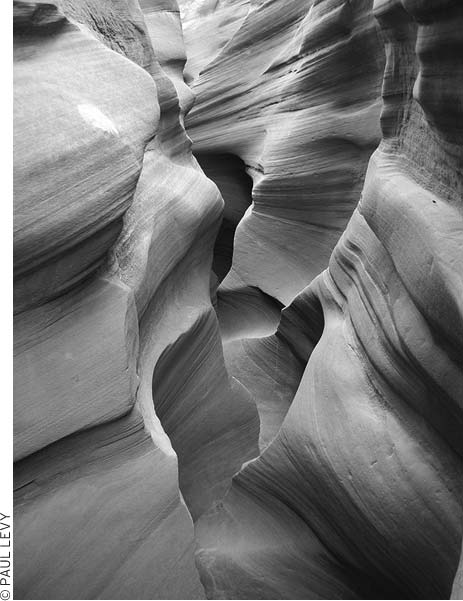
M Dry Fork of Coyote Gulch: To explore the enchanting slot canyons of this area, it’s necessary to drive 26 miles along the bumpy dirt Hole-in-the-Rock Road. If you and your vehicle are up for such a drive, don’t miss it. The slot canyons are easy enough for reasonably fit people to explore, and they’ll give you a taste of canyoneering (click here).
LOOK FOR M TO FIND RECOMMENDED SIGHTS, ACTIVITIES, DINING, AND LODGING.
The other districts offer less-well-defined opportunities for adventure. Backcountry drivers and long-distance mountain bikers will find mile after mile of desert and canyon to explore. Grosvenor Arch, with double windows, is a popular back-road destination. At the southern edge of the park, along the Arizona border, is another rugged canyon system that’s popular with long-distance hikers. The Paria River Canyon is even more remote than the Escalante, and hiking these slot canyons requires experience and preparation.
If you only have one day, plan to drive stunning Highway 12. The Lower Calf Creek Falls hike begins right off the highway between Escalante and Boulder, and hiking it is a great way to spend half a day.
If you have an additional day or two, it makes sense to base yourself either in Escalante (convenient camping and moderately priced accommodations) or in Boulder (where it’s possible to sleep and eat in luxury). Spend your second day here exploring Hole-in-the-Rock Road, where you can hike slot canyons in the Dry Fork of Coyote Gulch and explore Devils Garden. It’s possible to stay in this area of the monument for several days, either backpacking along the Escalante River or exploring its various canyons as day hikes. If you’re at all up to backpacking, it’s only a one-nighter to hike from the town of Escalante along the river to the river’s highway crossing.
If you have more time, drive between the Kanab area and Cannonville on Cottonwood Canyon Road (be sure to check on road conditions before heading out). Stop and walk up through the Cottonwood Narrows, and at the north end of the road, visit Grosvenor Arch and Kodachrome State Park. If you want to make a loop drive, return on the Johnson Canyon and Skutumpah Roads, with a hike along Lick Wash.
There is no entrance fee to visit Grand Staircase-Escalante National Monument (435/644-4600, www.ut.blm.gov/monument). Free permits are required for all overnight backcountry camping or backpacking. There is a fee to camp in the monument’s three developed campgrounds.
Hikers in the Paria Wilderness area, which includes Paria Canyon and Coyote Buttes, are required to buy a permit, as are hikers at the Calf Creek Recreation Area.
It’s best to have a travel strategy when visiting this huge national monument. Just as important, especially for a visit of more than a couple of days, is a vehicle that can take on some rugged roads. (A Subaru wagon proved perfectly adequate in dry weather, but when the clay was wet and muddy, the back roads were virtually impassable in all but 4WD vehicles with significantly higher clearance than a station wagon.)
Only two paved roads pass through the monument, both on a west-east trajectory. Highway 12, on the northern boundary of the park, links Bryce Canyon and Capitol Reef National Parks with access to the Escalante canyons. This is one of the most scenic roads in Utah—in fact, Car and Driver magazine rates this route as one of the 10 most scenic in the United States. Its innumerable vistas and geologic curiosities will keep you on the edge of your seat. U.S. 89, which runs along the southern edge of the monument between Kanab and Lake Powell, is no scenery slouch either. It is also the access road for the north rim of the Grand Canyon in Arizona.
Three fair-weather dirt roads, each with a network of side roads and trails, cut through the rugged heart of the monument, linking the two paved roads. Before heading out on these back roads, check with the visitors center for conditions; high-clearance vehicles are recommended.
The administrative headquarters of the GSENM (669 S. U.S. 89A, Kanab, 435/644-1200, www.ut.blm.gov/monument, 8am-4:30pm Mon.-Fri.) is about 15 miles from the southwestern edge of the monument in Kanab, but the regional visitors centers, listed below, are the best places for practical travel information.
Escalante Interagency Visitor Center (755 W. Main St., Escalante, 435/826-5499, 8am-4:30pm daily mid-Mar.-mid-Nov., 8am-4:30pm Mon.-Fri. mid-Nov.-mid-Mar.) is housed in a sprawling building at the west end of the town of Escalante. Staff are very knowledgeable and helpful, and exhibits focus on the monument’s ecology and biological diversity.
Kanab Visitor Center (745 E. U.S. 89, Kanab, 435/644-1300, 8am-4:30pm daily) is the place to stop if you’re planning to drive Cottonwood or Johnson Canyon and Skutumpah Roads from the south. Staff can give you updates on the road conditions and suggest driving and hiking strategies. Exhibits at this visitors center concentrate on geology and archaeology.
Cannonville Visitor Center (10 Center St., Cannonville, 435/826-5640, 8am-4:30pm daily mid-Mar.-mid-Nov.) is an attractive building at the north end of Cottonwood and Johnson Canyon-Skutumpah Roads. Even if the office is closed, stop by to look at the outdoor exhibits, which depict the different cultures that have lived in the area.
Big Water Visitor Center (100 Upper Revolution Way, Big Water, 435/675-3200, 9am-5:30pm daily Apr.-Oct., 8am-4:30pm daily Nov.-Mar.), a spiral-shaped building designed to resemble an ammonite, is home to a small but distinctive collection of dinosaur bones and a wild mural depicting late-Cretaceous life in the area. Stop here to learn about local paleontology.
Anasazi State Park (460 N. Hwy. 12, Boulder, 435/335-7382, www.stateparks.utah.gov, 9am-5pm daily mid-Mar.-mid-Nov., $5) has a ranger on duty at an information desk inside the museum. The museum is worth a visit, so don’t be stingy with your five bucks!
Paria Contact Station (U.S. 89, 44 miles east of Kanab, no phone, 9am-3pm daily Mar. 15-Nov. 15) is a small visitors center, but it’s an important stop for anyone planning to hike Paria Canyon.
For guided tours of the Escalante canyons, contact Utah Canyons Outback Adventures (325 W. Main St., Escalante, 435/826-4967, www.utahcanyons.com). Trips focus on day hikes (full-day from $110), with popular trips going to slot canyons and scenic Phipps Arch. It also offers hiker shuttles and runs a good gear shop in the salmon-colored building in downtown Escalante.
Escalante Interagency Visitor Center, in the town of Escalante, is a good place to plan trips into the monument.
The guides at Excursions of Escalante (125 E. Main St., Escalante, 800/839-7567, www.excursionsofescalante.com) lead trips into more remote canyons, including some that require some technical canyoneering to explore, and some multiday backpacking trips. Straightforward hiking trips (from $130) are also offered, either cross-country (easiest) or in slot canyons (more challenging). A day of basic canyoneering ($150) includes instruction.
Many local outfitters use pack animals. With Escape Goats (435/826-4652, www.utahpackgoats.com), you can hike with goats (and a friendly, goat-loving human guide) into canyons. This is a good bet for families with kids. A variety of hikes are available; full-day hikes start at $80 pp.
Hike into the canyon backcountry (let horses carry your gear) and spend a few days exploring with Escalante Canyon Outfitters (435/335-7311 or 888/326-4453, www.ecohike.com). Five-day trips run about $1,600.
Red Rock ’n Llamas (435/559-7325 or 877/955-2627, www.redrocknllamas.com) offers a variety of fully outfitted hiking adventures in the Escalante area. Llamas will carry most of the gear, leaving you to explore in comfort. Most trips are for 3-4 nights and cost $900-1,000.
Boulder-based Earth Tours (435/691-1241, www.earth-tours.com) offers full-day (from $100 pp) to six-day (price varies with number of guests) tours of the area. Most trips are led by a geologist with a wide-ranging interest in natural history.
Highway 12 runs west-east from Bryce Canyon National Park and Tropic along the north edge of the monument to the towns of Escalante and Boulder. Stop at the Cannonville Visitor Center (10 Center St., Cannonville, 435/826-5640, 8am-4:30pm daily mid-Mar.-mid-Nov.) for information about back-road conditions and hikes in this part of the monument. Two backcountry roads depart from Cannonville and lead to remote corners of the monument.
The northern end of the Johnson Canyon-Skutumpah Road (46 miles one-way) is in Cannonville, and its southern terminus is at U.S. 89, just east of Kanab. From the northernmost stretch of this road, Bryce Canyon rises to the west; about six miles from the southern end and off to the east on private land (look from the road but don’t trespass) is the set from the TV show Gunsmoke.
The unpaved portions of the road are usually in good condition, except after rains, when the bentonite soils that make up the roadbed turn to goo. In good weather, cars can usually make the journey. The road follows the Pink and White Cliff terraces of the Grand Staircase, with access to some excellent and comparatively undersubscribed hiking trails. Several steep slot canyons make for excellent canyoneering. The lower 16 miles of Johnson Canyon Road are paved.
The 46-mile Cottonwood Canyon Road also connects Cannonville with U.S. 89, but it passes through quite different terrain and landscapes. One of the most scenic backcountry routes in the monument, Cottonwood Canyon Road not only offers access to dramatic Grosvenor Arch; it also passes along the Cockscomb, a soaring buckle of rock that divides the Grand Staircase and the Kaiparowits Plateau. Cottonwood Creek, which this road parallels, is a normally dry streambed that cuts through the angular rock beds of the Cockscomb. Several excellent hikes lead into the canyons and narrows, where the Paria River, Hackberry Canyon, and Cottonwood Creek all meet, about 20 miles south of Cannonville.
Check at the Cannonville or Big Water Visitor Center for information about road conditions. Although the road is sometimes passable for cars, several road crossings are susceptible to washouts after rainstorms, and the northern portion is impassable even to 4WD vehicles when wet because of the extremely unctuous nature of the roadbed. Check conditions before setting out if you plan to go beyond Grosvenor Arch.
Visitors come to Kodachrome Basin State Park (435/679-8562, www.stateparks.utah.gov, 6am-10pm daily, $6), located in a basin southeast of Bryce, to see not only colorful cliffs but also strange-looking rock pillars that occur nowhere else in the world. Sixty-seven rock pillars (here called “sand pipes”) found in and near the park range in height from 6 feet to nearly 170 feet. One theory of their origin is that earthquakes caused sediments deep underground to be churned up by water under high pressure. The particles of calcite, quartz, feldspar, and clay in the sand pipes came from underlying rock formations, and the pipes appeared when the surrounding rock eroded away. Most of the other rocks visible in the park are Entrada sandstone: The lower orange layer is the Gunsight Butte Member, and the white layer with orange bands is the Cannonville Member.
Signs name some of the rock features. “Big Stoney,” the phallus-shaped sand pipe overlooking the campground, is so explicit that it doesn’t need a sign. The article “Motoring into Escalante Land” by Jack Breed in the September 1949 National Geographic magazine brought attention to the scenery and earned the area the name “Kodachrome Flat,” for the then-experimental Kodak film used by the expedition. The state park is a worthwhile stop, both as a day trip to see the geology and as a pleasant spot to camp. The park also offers several good half-day hiking trails and a host of shorter hikes.
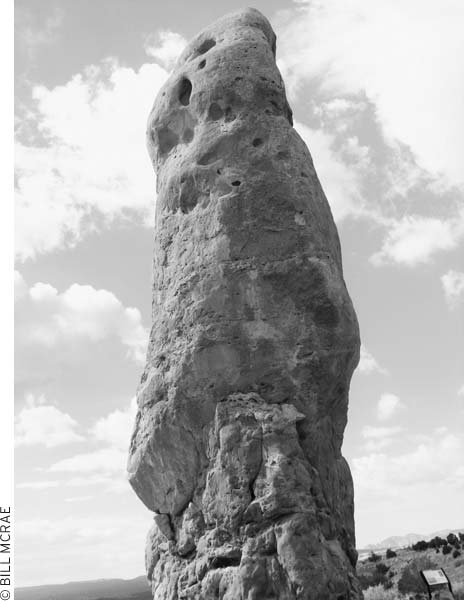
sandstone spires, called “pipes,” at Kodachrome Basin State Park
Supplies and accommodations are available in the park at the Kodachrome General Store, which also operates Red Stone Cabins (435/679-8536, www.redstonecabins.com, summer high season $99), six well-maintained log structures in a lovely setting. All have private baths and efficiency kitchens.
The state park’s campground (435/679-8562, reservations 800/322-3770 or www.reserveamerica.com, year-round, $16) is in a natural amphitheater at an elevation of 5,800 feet. It has restrooms, showers, and a dump station. During the winter, restrooms and showers may close, but pit toilets are available. The campground usually has space except on summer holidays.
To reach the park, take Highway 12 south to Cannonville and follow the signs for seven miles along paved Cottonwood Canyon Road. Adventurous drivers can also approach the park from U.S. 89 to the south via Cottonwood Canyon Road (35 miles) or Skutumpah Road through Bull Valley Gorge and Johnson Canyon (48 miles). These routes may be impassable in wet weather but are generally OK in dry weather for cars with good clearance.
Just one mile off Cottonwood Canyon Road, a side road leads to the magnificent Grosvenor Arch. It takes a bit of effort to get here (the 10-mile dirt road between the turnoff to Kodachrome Basin State Park and the arch can be bumpy and should be avoided in wet weather), so a visit to the arch can take on the qualities of a pilgrimage. There are actually two arches here, which is a rare occurrence for such erosion-formed arches. Their position, jutting like flying buttresses out of a soaring cliff, is also quite stunning. The larger of the two openings is 99 feet across. A 1949 National Geographic Society expedition named the double arch in honor of the society’s president. From Highway 12, take the Cottonwood Canyon Road turnoff to Kodachrome Basin State Park. Continue for 10 miles to the Grosvenor Arch parking area. Alternatively, the turnoff is 29 miles north from U.S. 89.
Kodachrome Basin has one of the nicest campgrounds in the area.
The pleasant Escalante Petrified Forest State Park (435/826-4466, www.stateparks.utah.gov, 7am-10pm daily summer, 8am-10pm daily winter, $6), just northwest of the town of Escalante, offers camping, boating, fishing, picnicking, hiking, a visitors center with displays of petrified wood and dinosaur bones, and a chance to see petrified wood along hiking trails. Rivers of 140 million years ago carried trees to the site of present-day Escalante and buried them in sand and gravel. Burial prevented decay as crystals of silicon dioxide gradually replaced the wood cells. Mineral impurities added a rainbow of colors to the trees as they turned to stone. Weathering has exposed this petrified wood and the water-worn pebbles and sand of the Morrison Formation.
For a look at some colorful petrified wood, follow the Petrified Forest Trail from the campground up a hillside wooded with piñon pine and juniper. At the top of the 240-foot-high ridge, continue on a loop trail to the petrified wood; allow 45-60 minutes for the one-mile round-trip hike. The steep Rainbow Loop Trail (0.75 miles) branches off the Petrified Forest Trail to more areas of petrified wood.
The campground (reservations 800/322-3770, www.reserveamerica.com, year-round, $16) offers drinking water, flush toilets, showers, and RV hookups ($20). The adjacent 139-acre Wide Hollow Reservoir offers fishing, boating, and bird-watching. The park is 1.5 miles west of Escalante on Highway 12, then 0.7 miles north on a gravel road.
The town of Escalante, 38 miles east of Bryce Canyon and 23 miles south of Boulder, has a full range of services and is the headquarters for explorations of the Escalante River canyons. The Escalante Interagency Visitor Center (755 W. Main St., Escalante, 435/826-5499) provides information on local hikes and road conditions.
From Escalante, it’s 78 miles south to U.S. 89 at Big Water, just shy of Lake Powell, along Smokey Mountain Road. This road is rougher than other cross-monument roads. Be sure to check on conditions before setting out; a 4WD vehicle is required. As this route passes across the Kaiparowits Plateau, the landscape is bleak and arid. After that, the road drops precipitously down onto a bench where side roads lead through badlands to Lake Powell beaches. Big Water is 19 miles from Page, Arizona, and 57 miles from Kanab.
The building of this road by determined Mormons is an epic story of the colonization of the West. Church leaders organized the Hole-in-the-Rock Expedition to settle the wildlands around the San Juan River of southeastern Utah, believing that a Mormon presence would aid in ministering to the Native Americans there and prevent non-Mormons from moving in. In 1878 the Parowan Stake issued the first call for a colonizing mission to the San Juan, even before a site had been selected.
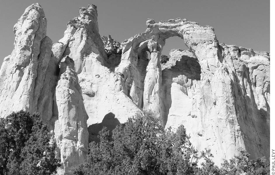
With its flying buttresses, Grosvenor Arch is one of the most distinctive of Utah’s many arches.
Preparations and surveys took place the following year as the 236 men, women, and children received their calls. Food, seed, farming and building tools, 200 horses, and more than 1,000 head of cattle were brought along. Planners ruled out lengthy routes through northern Arizona or eastern Utah in favor of a straight shot via Escalante that would cut the distance in half. The expedition set off in the fall of 1879, convinced that they were part of a divine mission.
Hints of the trouble to come filtered back from the group as they discovered the Colorado River crossing to be far more difficult than first believed. Lack of water sources along the way added to their worries. From their start at Escalante, road building progressed rapidly for the first 50 miles, then slowly over rugged slickrock for the final six miles to Hole-in-the-Rock. A sheer 45-foot drop below this narrow notch was followed by almost one mile of extremely steep slickrock to the Colorado River. The route looked impossible, but three crews of workers armed with picks and blasting powder worked simultaneously to widen the notch and construct a precarious wagon road down to the river and up the cliffs on the other side.
The job took six weeks. Miraculously, all of the people, animals, and wagons made it down and were ferried across the Colorado River without serious incident. Canyons and other obstacles continued to block the way as the weary group pressed on. Only after six months of exhausting travel did they stop at the present-day site of Bluff on the San Juan River.
Today, on a journey from Escalante, you can experience a bit of the same adventure the pioneers knew. Except for scattered signs of ranching, the land remains unchanged. If the road is dry, vehicles with good clearance can drive to within a short distance of Hole-in-the-Rock. The rough conditions encountered past Dance Hall Rock require more clearance than most cars allow. Bring sufficient gas, food, and water for the entire 126-mile round-trip from Escalante; there are no services along this route.

Near the town of Escalante, the Escalante River begins to trench through a layer cake of colorful rock.
Metate Arch and other rock sculptures decorate Devils Garden, 12.5 miles down Hole-in-the-Rock Road. Turn west and continue 0.3 miles at the sign to the parking area, because you can’t really see the “garden” from the road. Red and cream-colored sandstone formations sit atop pedestals or tilt at crazy angles. Delicate bedding lines run through the rocks. There are no trails or markers—just wander around as you like. The Bureau of Land Management (BLM) has provided picnic tables, grills, and outhouses for day use. No overnight camping is permitted at Devils Garden.
Dance Hall Rock (38 miles down Hole-in-the-Rock Rd.) jumped to the fiddle music and lively steps of the expedition members in 1879. Its natural amphitheater has a relatively smooth floor and made a perfect gathering spot when the Hole-in-the-Rock group had to wait three weeks at nearby Fortymile Spring for road work to be completed ahead. Dance Hall Rock is an enjoyable place to explore and only a short walk from the parking area. Solution holes, left by water dissolving in the rock, pockmark the sandstone structure.
At road’s end, 57 miles from Highway 12, continue on foot across slickrock to the notch and views of the blue waters of Lake Powell below. Rock slides have made the descent impossible for vehicles, but hikers can scramble down to the lake and back in about one hour. The elevation change is 600 feet. The 0.5-mile round-trip hike is strenuous. After a steep descent over boulders, look for steps of Uncle Ben’s Dugway at the base of the notch. Below this point, the grade is gentler. Drill holes in the rock once held oak stakes against which logs, brush, and earth supported the outer wagon wheels. The inner wheels followed a narrow rut 4-6 inches deep. About two-thirds of the route down is now under water, although the most impressive road work can still be seen.
The turnoff from Highway 12 is five miles east of Escalante. In addition to rewarding you with scenic views, Hole-in-the-Rock Road passes many side drainages of the Escalante River to the east and some remote country of the Kaiparowits Plateau high above to the west. Staff at the Escalante Interagency Visitor Center (755 W. Main St., Escalante, 435/826-5499, 8am-4:30pm daily mid-Mar.-mid-Nov., 8am-4:30pm Mon.-Fri. mid-Nov.-mid-Mar.), just west of Escalante, can give current road conditions and suggest hikes.
Be sure to pull off Highway 12 at the Boynton Overlook (Hwy. 12, 14 miles east of Escalante, at the Escalante River Bridge) and scan the walls on the far side of the Escalante River for the Hundred Hands pictograph (binoculars help immensely). For a closer look, take a 30-minute hike up from the parking lot at the bottom of the hill at the Escalante River crossing. Rather than hike along the river, go up above the house (don’t stray onto fenced-in private property), scramble up the face of the first cliff, and follow faint trails and rock cairns across the bench. It is easiest if you’ve located the pictographs first from the overlook. The Hundred Hands are high up on a cliff face that’s larger than the one you scrambled up. Follow the cliff to the right, where pictographs of goats are lower on the wall.
Back down at river level, head downstream a few hundred yards and look up to the left to see Anasazi ruins, known as the Moki House.
This stunning canyon and park at Calf Creek Recreation Area (day-use $2 per vehicle) offers the most accessible glimpse of what Escalante canyon country is all about. The trailhead to 126-foot Lower Calf Creek Falls is here, and you should definitely make plans for the half-day hike (6 miles round-trip, 3-4 hours), especially if you have no time for further exploration of this magical landscape. Otherwise, stop here to picnic in the shade of willows and cottonwoods. This is also the most convenient and attractive campground ($7) for dozens of miles. The 13 campsites have water, fire pits, and picnic tables.
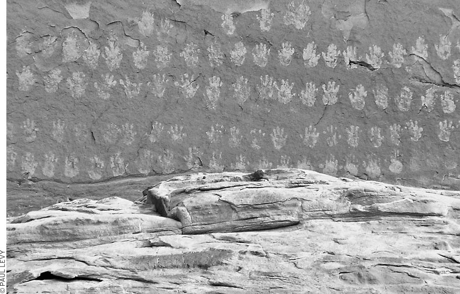
It takes binoculars and a little looking, but the Hundred Hands pictograph is visible from the Boynton Overlook.
Highway 12 between Escalante and Boulder was completed in 1935 by workers from the Civilian Conservation Corps. The cost was a budget-busting $1 million. Before then, mules carried supplies and mail across this wilderness of slickrock and narrow canyons. The section of Highway 12 between Calf Creek and Boulder is extraordinarily scenic—even jaded travelers used to the wonders of Utah will have to pull over and ogle the views from the Hog’s Back, where the road crests a fin of rock above the canyons of the Escalante. Be here for sunset on a clear evening and you’ll have a memory to carry for the rest of your life.
Boulder is a tiny community in a lovely location at the base of Boulder Mountain, where the alpine air mixes with the desert breezes. The single best lodging choice in the Escalante region—the Boulder Mountain Lodge—is here, so plan accordingly.
At the excellent Anasazi State Park (Hwy. 12, 1 mile north of Boulder, 435/335-7308, www.stateparks.utah.gov, 8am-6pm daily Apr.-Oct., 9am-5pm Mon.-Sat. Nov.-Mar., $5 pp), museum exhibits, an excavated village site, and a pueblo replica provide a look into the life of these ancient people. The Anasazi stayed here for 50-75 years some time between 1050 and 1200. They grew corn, beans, and squash in fields nearby. The village population peaked at about 200, with an estimated 40-50 dwellings. Why the Anasazi left or where they went isn’t known for certain, but a fire swept through much of the village before they abandoned it. Perhaps they burned the village on purpose, knowing they would move on. University of Utah students and faculty excavated the village, known as the Coombs Site, in 1958 and 1959. You can view pottery, ax heads, arrow points, and other tools found at the site in the museum, along with delicate items like sandals and basketry that came from more protected sites elsewhere. A diorama shows how the village might have appeared in its heyday. You can see video programs on the Anasazi and modern Native Americans on request.
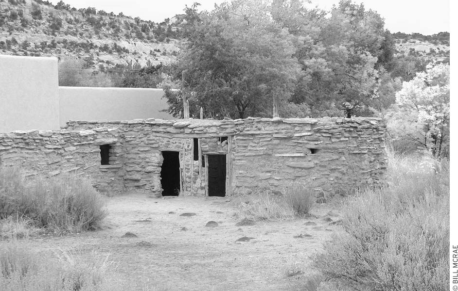
Anasazi State Park features excavated Anasazi structures.
The self-guided tour of the ruins begins behind the museum, one mile north of Boulder. You’ll see a whole range of Anasazi building styles—a pit house, masonry walls, jacal walls (mud reinforced by sticks), and combinations of masonry and jacal. Replicas of habitation and storage rooms behind the museum show complete construction details.
Burr Trail Road, originally a cattle trail blazed by stockman John Atlantic Burr, extends from the town of Boulder on Highway 12 to the Notom-Bullfrog Road, which runs between Highway 24 near the eastern entrance to Capitol Reef National Park and Bullfrog Marina on Lake Powell, off Highway 276. Starting at Boulder, the road is paved as far as the boundary between the GSENM and Capitol Reef National Park (31 miles), where the route traverses the Circle Cliffs, as well as spectacular canyon areas such as Long Canyon and the Gulch. As the route meets the Waterpocket Fold in Capitol Reef National Park, breathtaking switchbacks drop some 800 feet in just 0.5 miles. These switchbacks are not considered suitable for RVs or vehicles towing trailers. The unpaved sections of the road may be impassable in poor weather. Visitors should inquire about road and weather conditions before setting out. Also inquire about hiking trails that depart from side roads.
Burr Trail Road joins Notom-Bullfrog Road just before it exits Capitol Reef National Park.
In this region, U.S. 89 runs from Kanab to the Utah-Arizona border. From Kanab to Page, Arizona, at the Colorado River’s Glen Canyon Dam, is 80 miles.
Eight miles east of Kanab, Johnson Canyon Road heads north along the western border of the monument before joining Skutumpah Road and Glendale Bench Road. This road system links up with several more remote backcountry roads in the monument, and it eventually leads to Cannonville along Highway 12. From U.S. 89, Johnson Canyon Road is paved for the first 16 miles. The road passes an abandoned movie set, where the TV series Gunsmoke was sometimes filmed. The road then climbs up through the scenic Vermilion and then White Cliffs of the Grand Staircase. The road eventually passes over Skutumpah Terrace, a rather featureless plateau covered with scrub.
This road has several names, including Paria Valley and Paria Breaks Road. It turns north off U.S. 89 at milepost 31. The five-mile dirt road is passable to cars when dry. It passes some towering and colorful canyons and mesas, among which the remains of a 1930s Western movie set are slowly decaying. From the parking area, walking trails lead to the abandoned bleached wood buildings, which make for great photo opportunities against the rugged backdrop. Farther along the road, as it approaches the Paria River, are the remains of Pahreah, although there’s not much left of this ghost town.
Paria Canyon—a set of magnificent slot canyons that drain from Utah down through northern Arizona to the Grand Canyon—is the focus of popular multiday canyoneering expeditions. Paria Canyon and 293,000 acres of surrounding desert grasslands are now protected as Vermilion Cliffs National Monument (www.blm.gov). Although the monument spreads south from the Utah-Arizona border, access to the monument’s most famous sites is from back roads in Utah. In addition to the long Paria Canyon backpacking route, some shorter but strenuous day hikes explore this area. For more information, contact the Kanab Visitor Center (745 E. U.S. 89, Kanab, 435/644-4680, 9am-3pm daily Mar. 15-Nov. 15) or stop at the Paria Contact Station (U.S. 89, 44 miles east of Kanab, no phone, 9am-3pm daily Mar. 15-Nov. 15), near milepost 21 on U.S. 89.
A few miles east of the Paria Contact Station (milepost 21 on U.S. 89), Cottonwood Canyon Road leads north. The unpaved road’s lower portions, usually passable with a car in dry weather, pass through scenic landscapes as the road pushes north. The route climbs up across a barren plateau before dropping down to the Paria River. Several good hikes lead from roadside trailheads into steep side canyons. The route continues north along the Cockscomb, a long wrinkle of rock ridges that run north and south across the desert. At the northern end of this 46-mile route are Grosvenor Arch, Kodachrome State Park, and Highway 12.
At the little crossroads of Big Water, the GSENM has built a visitors center (100 Upper Revolution Way, Big Water, 435/675-3200, 9am-5:30pm daily Apr.-Oct. and 8am-4:30pm daily Nov.-Mar.) to serve the needs of travelers to the monument and to Glen Canyon National Recreation Area (NRA), which is immediately adjacent to this area. The visitors center is definitely worth a stop—it houses bones from a 75-million-year-old, 30-foot-long duck-billed dinosaur. The backbone, bearing tooth marks from a tyrannosaur, and the 13-foot-long tail are especially impressive.
Joining U.S. 89 at Big Water is Smokey Mountain Road. This long and rugged road links Big Water to Highway 12 at Escalante, 78 miles north. The southern portions of the route pass through Glen Canyon NRA, and side roads lead to remote beaches and flooded canyons. The original Planet of the Apes movie was shot here, before the area was inundated by Lake Powell.
From Big Water it is 19 miles to Page, Arizona, on U.S. 89.
The GSENM preserves some of the best long-distance hiking trails in the American Southwest, but it also has shorter trails for travelers who want to sample the wonderful slot canyons and backcountry without venturing too far afield.
Be sure to check at local visitors centers for road and trail conditions, up-to-date maps, and if you’re backpacking, a free backcountry permit, which is required for overnight stays. Many of the following hikes require extensive travel on backcountry roads, which can be impassable after rains and rough the rest of the time. In summer, these trails are hot and exposed; always carry plenty of water and sunscreen, and wear a hat.
Hiking the Escalante River Canyon is one of the world’s greatest wilderness treks. Most people devote 4-6 days to exploring these slickrock canyons, which involves frequent scrambling (if not rock climbing), stream fording (if not swimming), and exhausting detours around rock falls and logjams. Most of the day hikes are along side canyons of the Escalante River and can be reached by trailheads off Hole-in-the-Rock Road or Burr Trail. A couple of shorter hikes—Lower Calf Creek Falls and Escalante Natural Bridge—start quite conveniently from Highway 12. Another good jumping-off point for day hikers is the Dry Fork Coyote Gulch Trailhead, 26 miles south of Highway 12 on Hole-in-the-Rock Road; trails here lead to two fascinating and beautifully constricted slot canyons.
The Paria Canyon is another famed long-distance slickrock canyon hike that covers 37 miles between the border of Utah and the edge of the Colorado River’s Marble Canyon. Several long day hikes leave from trailheads on the Paria Plateau, along the border with Arizona.
Other areas with developed hiking trails include the Skutumpah Road area and Cottonwood Canyon, in the center of the park. Otherwise, hiking in the monument is mostly on unmarked routes. Although the park is developing more day hiking options, the rangers encourage hardy adventurers to consider extended hikes across the rugged and primitive outback, beyond the busy canyon corridors. Call one of the visitors centers and ask for help from the rangers to plan a hiking adventure where there are no trails.
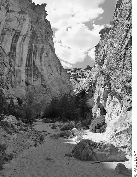
The northern portions of this road pass through the White Cliffs area of the Grand Staircase, and several steep and narrow canyons are trenched into these terraces. Rough hiking trails explore these slot canyons. As when hiking any slot canyon, be sure to check the weather report before venturing up-canyon, and beware of changes in weather; flash floods can strike fast, and they are especially common in mid-late summer.
• Distance: 4.4 miles round-trip
• Duration: 3-4 hours
• Elevation change: 40 feet
• Effort: easy
• Trailhead: 9 miles south of Cannonville along Skutumpah Road
This relatively easy trail follows a small stream as it etches a deep and narrow gorge through the sandstone. From the parking area, where Skutumpah Road crosses Willis Wash, walk downstream along the wash. Follow the streambed, which quickly descends between slickrock walls. The canyon is at times no more than 6-10 feet across, while the walls rise 200-300 feet. The trail follows the streambed through the canyon for nearly 2.5 miles. To return, backtrack up the canyon. Use caution when hiking during flash flood season.
• Distance: 2 miles round-trip
• Duration: 1-2 hours
• Elevation change: 850 feet
• Effort: moderate-strenuous
• Trailhead: 10.5 miles south of Cannonville along Skutumpah Road
Approximately 1.5 miles south of Willis Creek on Skutumpah Road, a narrow bridge vaults over the Bull Valley Gorge. Like the Willis Creek Narrows, this is a steep and narrow cleft in the slickrock; however, scrambling along the canyon bottom is a greater challenge. From the bridge, walk upstream along a faint trail on the north side of the crevice until the walls are low enough to scramble down. From here, the canyon deepens quickly, and you’ll have to negotiate several dry falls along the way (a rope will come in handy). When you reach the area below the bridge, look up to see a 1950sera pickup truck trapped between the canyon walls. Three men died in this 1954 mishap; their bodies were recovered, but the pickup was left in place. The canyon continues another mile from this point; after that the valley widens out a bit. There is no loop trail out of the canyon, so turn back when you’ve seen enough.
• Distance: 4 miles one-way to Park Wash
• Duration: 4-5 hours
• Elevation change: 200 feet
• Effort: easy
• Trailhead: 20 miles south of Cannonville along Skutumpah Road
From Lick Wash, trails lead downstream into slot canyons to a remote arroyo (dry riverbed) surrounded by rock-topped mesas. One of these lofty perches contains a preserve of now-rare native grasses. Although this area can be reached in a day’s hike, this is also a good place to base a multiday camping trip. The trail starts just below the road crossing on Lick Wash and follows the usually dry streambed as it plunges into a narrow slot canyon. The canyon bottom is mostly level and easy to hike. After one mile, the canyon begins to widen; after four miles, Lick Wash joins Park Wash, a larger desert canyon.
Looming above this canyon junction are mesas topped with deep sandstone terraces. Rising to the east is No Mans Mesa, skirted on all sides by steep cliffs. The 1,788 acres atop the mesa were grazed by goats for six months in the 1920s, but since then the pristine grassland has been protected by the BLM as an Area of Critical Environmental Concern. Hardy hikers can scramble up a steep trail—used by the goats—to visit this wilderness preserve. The ascent of No Mans Mesa is best considered an overnight trip from Lick Wash Trailhead.
The northern portions of this route pass by Kodachrome Basin State Park, with a fine selection of hiking trails through colorful rock formations. The first five hikes in this section are in Kodachrome Park. For a brief introduction to the park’s ecology, follow the short Nature Trail.
• Distance: 3 miles round-trip
• Duration: 2 hours
• Elevation change: 350 feet
• Effort: easy
• Trailhead: west side of park road, south of Trailhead Station
The Panorama Trail loops through a highly scenic valley with sand pipes and colorful rocks. The trail then leaves the valley and climbs up the rocks, offering good views of the park’s formations. The most spectacular views are found at Panorama Point, which requires a short steep climb up a few switchbacks. If the three-mile loop leaves you thirsty for more hiking (and you’re carrying an adequate supply of water), several spur trails offer the opportunity for a longer loop. Be sure to pick up a map of the park’s hiking trails before you begin; they’re available in several locations, including the Kodachrome General Store.
• Distance: 1.5 miles round-trip
• Duration: 30-45 minutes
• Elevation change: 300 feet
• Effort: easy-moderate
• Trailhead: Kodachrome Basin State Park, just east of group campground
From the trailhead, hike up the butte to its top, where you’re rewarded with fine views of the park and surrounding area, including Bryce Canyon. Once on top of the butte, the trail is level, and the hike becomes an easy amble. It’s easy to spend quite a bit of time exploring the plateau. Note that horseback riders share this trail.
• Distance: 1.5 miles round-trip
• Duration: 1.5 hours
• Elevation change: 100 feet
• Effort: easy
• Trailhead: Kodachrome Basin State Park, Trailhead Station
The Grand Parade Trail makes a loop with good views of rock pinnacles. It stays on the floor of the canyon, so it’s much gentler than some of the park’s other hikes. But it’s not dull—the trail visits a couple of box canyons and rock formations that resemble marchers in a parade. Horses and bicycles are permitted on this trail.
• Distance: 1 mile round-trip
• Duration: 30 minutes
• Elevation change: 1,000 feet
• Effort: moderate-strenuous
• Trailhead: north of Kodachrome Basin State Park campground
Eagle’s View Trail, a segment of a historic cattle trail, climbs steep cliffs above the campground. The highest overlook is a steep 0.25-mile ascent from the campground, but if you just want a good view, hike just to the top of the second set of stairs—after this point, the trail gets very narrow and exposed. Because this trail is so steep and has significant exposure, it’s not good for young children. It’s also best to avoid it in gusty winds.
• Distance: 1 mile round-trip
• Duration: 30 minutes
• Elevation change: 50 feet
• Effort: easy
• Trailhead: From the main park road, head east past the Arch group campground, turn right (south), and follow signs to Shakespeare Arch.
Although the arch is the destination of this trail, the trailside plants and excellent views are other highlights of this easy hike. Pick up a brochure at the trailhead to help with plant identification. The arch, which is 20 feet across and 90 feet high, is tucked into a small out-of-the-way cove and was not discovered until 1976, when a ranger searching for a coyote den stumbled across it. Note that just because you’ve seen this arch doesn’t mean you should skip Grosvenor Arch. Think of Shakespeare Arch as an appetizer for the main course down the road at Grosvenor.
• Distance: 22 miles one-way
• Duration: 3 days
• Elevation change: 1,300 feet
• Effort: strenuous
• Trailhead: southern end of BLM Road 422
• Directions: Head south on Cottonwood Canyon Road for 7.5 miles, from where the pavement ends at Kodachrome Basin State Park to the crossing of Round Valley Draw. From here, turn south on BLM Road 422.
Hikers can travel the 22-mile length of this scenic canyon in three days, or take day hikes from either end of the trail. The lower canyon meets Cottonwood Canyon at an elevation of 4,700 feet, just above the mouth of the Paria River. Cottonwood Canyon Road provides access to both ends. A small spring-fed stream flows down the lower half of Hackberry Canyon; hikers should expect to get their feet wet. Many side canyons invite exploration. One of them, Sam Pollock Canyon, is on the west side, about 4.5 miles upstream from the junction of Hackberry and Cottonwood Canyons; follow it 1.75 miles up to Sam Pollock Arch (60 feet high and 70 feet wide). Available topographic maps include the metric 1:100,000 Smoky Mountain or the 7.5-minute Slickrock Bench and Calico Peak. Michael Kelsey’s Hiking and Exploring the Paria River contains trail and trailhead information and a history of the Watson homestead, located a short way below Sam Pollock Canyon.
• Distance: 3 miles round-trip
• Duration: 2 hours
Cottonwood Narrows
• Effort: easy
• Trailhead: From the pavement’s end at Kodachrome Basin State Park, head south on Cottonwood Canyon Road. The northern end of the Cottonwood Narrows is 15 miles down the dirt road; the southern end is 1 mile farther south. Access is easier from the southern end.
This hike, through a narrow high-walled Navajo sandstone canyon, is good for casual hikers. The sandy-bottomed wash offers an easy path through the Cockscomb and a good look at the layers of warped rocks. Several side canyons join the wash; if you’re up for some scrambling, they can make for good exploring. Even on this short hike, remember to bring water. Use caution during flash flood season.
• Distance: 7 miles round-trip
• Duration: 4-5 hours
• Elevation change: 500 feet
• Effort: strenuous
• Trailhead: at the confluence of Cottonwood Creek and Paria River, 2.5 miles south of lower Hackberry Canyon trailhead (29 miles south of the pavement’s end at Kodachrome State Park, or from the south, 11.5 miles north of U.S. 89)
The confluence of Paria, Hackberry, and Cottonwood Canyons provides the backdrop to an excellent if strenuous day hike. The Box of the Paria River involves some steep climbs up rocky slopes as it traverses a tongue of slickrock between the mouth of the Hackberry and Paria Canyons. The route then follows the Paria River through its “box,” or cliff-sided canyon, in the Cockscomb Formation. The trail returns to the trailhead by following Cottonwood Canyon upstream to the trailhead. For an easier hike up the box, start at the Old Paria town site, at the northern end of Movie Set Road. Hike one mile down the Paria River, and then turn east into the box. Inquire at visitors centers for maps and about conditions.
The maze of canyons that drain the Escalante River presents exceptional hiking opportunities. You’ll find everything from easy day hikes to challenging backpacking treks. The Escalante’s canyon begins just downstream from the town of Escalante and ends at Lake Powell, about 85 miles beyond. In all this distance, only one road, Highway 12, bridges the river. Many side canyons provide additional access to the Escalante, and most are as beautiful as the main gorge. The river system covers such a large area that you can find solitude even in spring, the busiest hiking season. The many eastern canyons remain virtually untouched.
The Escalante canyons preserve some of the quiet beauty once found in Glen Canyon, which is now lost under the waters of Lake Powell. Prehistoric Anasazi and Fremont people have left ruins, petroglyphs, pictographs, and artifacts in many locations. These archaeological resources are protected by federal law: Don’t collect or disturb them.
Before setting out, visit the rangers at the Escalante Interagency Visitor Center (755 W. Main St., 435/826-5499, 8am-4:30pm daily mid-Mar.-mid-Nov., 8am-4:30pm Mon.-Fri. mid-Nov.-mid-Mar.), on the west edge of Escalante, for the required free permit to backpack overnight in the GSENM, and to check on the latest trail and road conditions. Restrictions on group size may be in force on some of the more popular trails. You can also obtain topographic maps and literature that show trailheads, mileages, and other information that may be useful in planning trips. Some of the more popular trailheads have self-registration stations for permits.
The best times for a visit are early March-early June and mid-September-early November. Summertime trips are possible, but be prepared for higher temperatures and greater flash-flood danger in narrow canyons. Travel along the Escalante River involves frequent crossings, and there’s always water in the main canyon, usually ankle- or knee-deep. Pools in the Narrows between Scorpion Gulch and Stevens Canyon can be up to chest-deep in spots (which you can bypass), but that’s the exception. Occasional springs, some tributaries, and the river itself provide drinking water. Always purify the water first; the BLM warns of the unpleasant disease giardiasis, which is caused by the invisible giardia protozoan. Don’t forget insect repellent—mosquitoes and deer flies seek out hikers in late spring and summer. Long-sleeved shirts and long pants also discourage biting insects and protect against the brush.
the deeply etched canyon of the Escalante River
For guided day hikes and hiking shuttles into the Escalante canyons, contact Utah Canyons (325 W. Main St., Escalante, 435/826-4967, www.utahcanyons.com).
The many approaches to the area allow all sorts of trips. Besides the Highway 12 access at Escalante and the Highway 12 bridge, hikers can reach the Escalante River through western side canyons from Hole-in-the-Rock Road or eastern side canyons from Burr Trail Road. The western-canyon trailheads on Hole-in-the-Rock Road can be more easily reached by car, thus facilitating vehicle shuttles. To reach eastern-canyon trailheads, with the exceptions of Deer Creek and the Gulch on Burr Trail Road, you’ll need lots of time and, if the road is wet, a sturdy 4WD vehicle. You must carry water for trips in these more remote canyons. With the exception of Deer Creek, they’re usually dry.
• Distance: 15 miles one-way
• Duration: 1-2 days
• Elevation change: 500 feet
• Trailhead: near the town of Escalante
• Directions: Follow signs from Highway 12 on the east side of town, by the high school, to the trailhead.
This section of the Escalante River offers easy walking and stunning canyon scenery. Tributaries and sandstone caves invite exploration. You’ll find good camping areas the entire way (be sure to get a permit for overnight camping). Usually the river here is only ankle deep. Almost immediately, the river knifes its way through the massive cliffs of the Escalante Monocline, leaving the broad valley of the upper river behind. Although there is no maintained trail along this stretch of the east-flowing river, it is relatively easy to pick your way along the riverbank.
Death Hollow, which is far prettier than the name suggests, meets the Escalante from the north after 7.5 miles. Several good swimming holes carved in rock are a short hike upstream from the Escalante; watch for poison ivy among the greenery. Continue farther up Death Hollow to see more pools, little waterfalls, and outstanding canyon scenery. You can bypass some pools, but others you’ll have to swim—bring a small inflatable boat, air mattress, or waterproof bag to ferry backpacks.
Sand Creek, on the Escalante’s north side, 4.5 miles downstream from Death Hollow, is also worth exploring; deep pools begin a short way up from the mouth. Another 0.5 miles down the Escalante, a natural arch appears high on the canyon wall. Then Escalante Natural Bridge comes into view, just two miles from the Highway 12 bridge.
• Distance: 2 miles one-way
• Duration: 2 hours
• Elevation change: 100 feet
• Effort: easy
• Trailhead: Highway 12 bridge over the Escalante River, between Escalante and Boulder
This hike upstream from the highway gives day hikers a taste of the Escalante River. After about 1.5 miles of hiking, you’ll see the arch (look up) and then the 130-foot-high natural bridge. Hike upstream from the bridge for better views of the arch. Continue hiking for another 0.5 miles beyond the arch to the point where Sand Creek enters the Escalante. Hot-weather hikers may want to head a short distance up Sand Creek to find deep pools.
• Distance: 2 miles one-way to Maverick Bridge
• Duration: 3 hours
• Elevation change: 300 feet
• Effort: easy
• Trailhead: Highway 12 bridge over the Escalante River, between Escalante and Boulder
Start this hike from the highway crossing and follow the Escalante River downstream to Phipps Wash, a lovely side canyon. A sign directs you to cross the Escalante River; heed it. Highlights of the hike are Maverick Bridge, about 0.5 miles up the wash in a side canyon, and Phipps Arch, visible high on the canyon wall above the wash. If you want to continue up the wash, the streambed trail gives way to a sandy wash, then slickrock. The head of Phipps Wash is about four miles from the Escalante River.
• Distance: 26.5 miles one-way
• Duration: 4-6 days
• Elevation change: 700 feet
• Effort: moderate
• Trailhead: Highway 12 bridge over the Escalante River
This is where many long-distance trekkers begin their exploration of the Escalante canyons. In this section, the Escalante Canyon offers a varied show: In places the walls close in to make constricted narrows; at others they step back to form great valleys. Side canyons filled with lush greenery and sparkling streams contrast with dry washes of desert, yet all can be fun to explore. A good hike of 4-6 days begins at the Highway 12 bridge, goes down the Escalante to Harris Wash, then up Harris to a trailhead off Hole-in-the-Rock Road (37 miles total).
From the Highway 12 bridge parking area, a trail leads to the river. Canyon access goes through private property; cross the river at the posted signs. Phipps Wash comes in from the south (the right side) after 1.5 miles and several more river crossings. Turn up its wide mouth for 0.5 miles to see Maverick Bridge in a drainage to the right. To reach Phipps Arch, continue another 0.75 miles up the main wash, turn left into a box canyon, and scramble up the left side (see the 7.5-minute Calf Creek topographic map).
Bowington (Boynton) Arch is an attraction in a north side canyon known locally as Deer Creek. Look for this small canyon on the left, one mile beyond Phipps Wash; hike up it for about one mile, past three deep pools, and then turn left into a tributary canyon. In 1878 gunfire resolved a quarrel between local ranchers John Boynton and Washington Phipps. Phipps was killed, but both their names live on.
Waters of Boulder Creek come rushing into the Escalante from the north in the next major side canyon, 5.75 miles below the Highway 12 bridge. The creek, along with its Dry Hollow and Deer Creek tributaries, provides good canyon walking; deep areas may require swimming or climbing up on the plateau. (You could also start down Deer Creek from Burr Trail Road, where they meet, 6.5 miles southeast of Boulder at a primitive BLM campground. Starting at the campground, follow Deer Creek 7.5 miles to Boulder Creek, then 3.5 miles down Boulder Creek to the Escalante.) Deer and Boulder Creeks have water year-round.
High sheer sandstone walls constrict the Escalante River in a narrow channel below Boulder Creek, but the canyon widens again above the Gulch tributary, 14 miles below the highway bridge. Hikers can head up the Gulch on a day hike.
Alternatively, hikers can descend the Gulch from Burr Trail Road to join the Escalante Canyon at this point (the Gulch trailhead is 10.8 miles southeast of Boulder). The hike from the road down to the Escalante is 12.5 miles, but there’s only one difficult spot: a 12-foot waterfall in a section of narrows about halfway down. When Rudi Lambrechtse, author of Hiking the Escalante, tried friction climbing around the falls and the pool at their base, he fell and broke his foot. That meant a painful three-day hobble out. Instead of taking the risk, Rudi recommends backtracking about 300 feet from the falls and climbing out from a small alcove in the west wall (look for a cairn on the ledge above). Climb up Brigham Tea Bench, walk south, then look for cairns leading back east to the narrows, and finally descend to the streambed (a rope helps to lower packs in a small chimney section).
Most springs along the Escalante are difficult to spot. One that’s easy to find is in the first south bend after the Gulch; water comes straight out of the rock a few feet above the river. Escalante Canyon becomes wider as the river lazily meanders along. Hikers can cut off some of the bends by walking in the open desert between canyon walls and riverside willow thickets. A bend cut off by the river itself loops to the north just before Horse Canyon, three miles below the Gulch. Along with its tributaries Death Hollow and Wolverine Creek, Horse Canyon drains the Circle Cliffs to the northeast. Floods in these mostly dry streambeds wash down pieces of black petrified wood. Vehicles with good clearance can reach the upper sections of all three canyons from a loop road off Burr Trail Road. Horse and Wolverine Creek Canyons offer good easy-moderate hiking, but if you really want a challenge, try Death Hollow, sometimes called Little Death Hollow to distinguish it from the larger one near Hell’s Backbone Road. Starting from the Escalante River, go about two miles up Horse Canyon and turn right into Death Hollow; rugged scrambling over boulders takes you back into a long section of twisting narrows. Carry water for Upper Horse Canyon and its tributaries. Lower Horse Canyon usually has water.
About 3.5 miles down the Escalante from Horse Canyon, you’ll enter Glen Canyon NRA and come to Sheffield Bend, a large grassy field on the right. Only a chimney remains from Sam Sheffield’s old homestead. Two grand amphitheaters are beyond the clearing and up a stiff climb in loose sand. Over the next 5.5 river miles to Silver Falls Creek, you’ll pass long bends, dry side canyons, and a huge slope of sand on the right canyon wall. Don’t look for any silver waterfalls in Silver Falls Creek—the name comes from streaks of shiny desert varnish on the cliffs. You can approach Upper Silver Falls Creek by a rough road from Burr Trail Road, but a car shuttle between here and any of the trailheads on the west side of the Escalante River would take all day. Most hikers visit this drainage on a day hike from the river. Carry water with you.
Harris Wash is to the right (west) side of the Escalante River almost opposite Silver Falls Creek. When the Hole-in-the-Rock route proved so difficult, pioneers figured there had to be a better way to the San Juan Mission. Their new wagon road descended Harris Wash to the Escalante River, climbed part of Silver Falls Creek, crossed the Circle Cliffs, descended Muley Twist Canyon in the Waterpocket Fold, and then followed Hall’s Creek to Hall’s Crossing on the Colorado River. Charles Hall operated a ferry there 1881-1884. Old maps show a jeep road through Harris Wash and Silver Falls Creek Canyons, used before the National Park Service closed off the Glen Canyon NRA section. Harris Wash is just 0.5 miles downstream and across the Escalante from Silver Falls Creek.
• Distance: 2.75 miles one-way
• Duration: 4 hours
• Elevation change: 250 feet
• Effort: easy-moderate
• Trailhead: Calf Creek Campground ($2 day-use), 16 miles east of Escalante on Highway 12
Calf Creek is a tributary of the Escalante River, entering it near Highway 12. The hike to Lower Calf Creek Falls is quite accessible for ordinary folks and is, for many people, the highlight of their first trip to the Escalante area. It’s the dazzling enticement that brings people back for longer and more remote hiking trips. From the trailhead and park just off Highway 12, the trail winds between high cliffs of Navajo sandstone streaked with desert varnish, where you’ll see beaver ponds, Native American ruins and pictographs, and the misty 126-foot-high Lower Calf Creek Falls. A brochure available at the trailhead next to the campground identifies many of the desert and riparian plant species along the way. Bring water and perhaps lunch. Summer temperatures can soar, but the falls and the crystal-clear pool beneath stay cool. Sheer cliffs block travel farther upstream.
Calf Creek Campground (early Apr.-late Oct., $7), near the road, has 13 sites with drinking water. Reserve group sites through the Escalante Interagency Visitor Center (755 W. Main St., Escalante, 435/826-5499, 8am-4:30pm daily mid-Mar.-mid-Nov., 8am-4:30pm Mon.-Fri. mid-Nov.-mid-Mar.).
• Distance: 1 mile one-way
• Duration: 1.5 hours
• Elevation change: 500 feet
• Effort: moderate
• Trailhead: just east of milepost 81 on Highway 12
• Directions: From Escalante, drive about 20.5 miles east on Highway 12. Turn left onto a dirt road between mileposts 80 and 81; the road may be marked by a black boulder with a white stripe. Drive 0.25 miles up the bumpy dirt road to the trailhead (park low-clearance vehicles at the turnoff and walk to the trailhead).
The hike to Upper Calf Creek Falls is more strenuous and less used than the trail to the lower falls. It’s also entirely different in nature, so don’t feel that, if you’ve hiked to the lower falls, the upper falls trip will be a mere repeat. This hike starts with a fairly steep descent across slickrock and then continues along a sandy trail. At a fork, you can choose to hike down to the base of the 87-foot-high falls or stay high and continue across more slickrock to the top of the falls and some deep pools in the stream. Near the bottom of the falls are hanging gardens and thick vegetation. At the top, paintbrush grows out of cracks in the slickrock.
• Distance: 10.25 miles one-way from trailhead to Escalante River
• Duration: 2 days round-trip
• Elevation change: 700 feet
• Effort: moderate
• Trailhead: Harris Wash Trailhead off Hole-in-the-Rock Road
• Directions: From Highway 12, turn south and travel on Hole-in-the-Rock Road for 10.8 miles, then turn left and go 6.3 miles on a dirt road (keep left at the fork near the end).
Clear shallow water glides down this gem of a canyon. High cliffs streaked with desert varnish are deeply undercut and support lush hanging gardens. Harris Wash provides a beautiful route to the Escalante River, but it can also be a destination in itself; tributaries and caves invite exploration along the way. The sand and gravel streambed makes for easy walking. Don’t be dismayed by the drab appearance of upper Harris Wash. The canyon and creek appear a few miles downstream. The Harris Wash Trailhead is restricted to a maximum of 12 people per group.
• Distance: 42.75 miles one-way
• Duration: 8-9 days
• Elevation change: 1,000 feet
• Effort: moderate
• Trailhead: Harris Wash Trailhead off Hole-in-the-Rock Road
• Directions: From Highway 12, turn south on Hole-in-the-Rock Road and take it 10.8 miles, then turn left and go 6.3 miles on a dirt road (keep left at the fork near the end).
The Escalante continues its spectacular show of wide and narrow reaches, side canyons, and intriguing rock formations. A trip all the way from Harris Wash Trailhead to the Escalante, down the Escalante River to near Lake Powell, then out to the Hurricane Wash trailhead is 66.25 miles and requires 8-10 days. Many shorter hikes using other side canyons are also possible.
Still in a broad canyon, the Escalante flows past Fence Canyon (to the west), 5.5 miles from Harris Wash. Fence Canyon has water and is a strenuous 3.5-mile cross-country route out to the end of Egypt Road. Get trail directions from a ranger, and bring a topographic map. (Adventurous hikers could do a three-day, 20-mile loop via Fence Canyon, the Escalante River, and the northern arm of Twentyfive Mile Wash. To reach the trailheads, take Hole-in-the-Rock Road 17.2 miles south of Highway 12, then turn left—east—and go 3.7 miles on Egypt Road to Twentyfive Mile Wash trailhead, or 9.1 miles to Egypt trailhead.)
Twentyfive Mile Wash, on the west side, 11.5 miles below Harris Wash, is a good route for entering or leaving the Escalante River. The moderately difficult hike is 13 miles one-way from trailhead to river. Scenery changes from an uninteresting dry wash in the upper part to a beautiful canyon with water and greenery in the lower reaches. To get to the trailhead, take Hole-in-the-Rock Road 17.2 miles south of Highway 12, then turn left and drive 3.7 miles on Egypt Road.
Moody Creek enters the Escalante six meandering river miles below Twentyfive Mile Wash (or just 2.25 miles as the crow flies). A rough road off Burr Trail Road gives access to Moody Creek, Purple Hills, and other eroded features. The distance from trailhead to river is seven miles one-way (moderately strenuous), although most hikers find it more convenient to hike up from the Escalante. Middle Moody Creek enters Moody Creek three miles above the Escalante. Moody and Middle Moody Canyons feature colorful rock layers, petrified wood, a narrows, and solitude. Carry water because springs and water pockets cannot be counted on. Canyons on the east side of the Escalante tend to be much drier than those on the west side.
East Moody Canyon enters the Escalante 1.5 miles downstream from Moody Canyon, and it also makes a good side trip. There’s often water about 0.5 miles upstream. Continuing down the Escalante, look on the left for a rincón, a meander cut off by the river. Scorpion Gulch enters through a narrow opening on the right, 6.5 miles below Moody Canyon. A strenuous eight-mile climb up Scorpion Gulch over rockfalls and around deep pools brings you to a trailhead on Early Weed Bench Road. Experience, directions from a ranger, and a topographic map are needed. A challenging four-day, 30-mile loop hike uses Fox Canyon, Twentyfive Mile Wash, the Escalante River, and Scorpion Gulch. Water is found only in lower Twentyfive Mile Wash, the river, and lower Scorpion Gulch. The Early Weed Bench turnoff is 24.2 miles south on Hole-in-the-Rock Road from Highway 12; head in 5.8 miles to Scorpion Gulch Trailhead.
In the next 12 miles below Scorpion Gulch, Escalante Canyon is alternately wide and narrow. Then the river plunges into The Narrows, a five-mile-long section choked with boulders; plan on spending a day picking a route through this stretch. Watch out for chest-deep water here. Remote and little-visited Stevens Canyon enters from the east near the end of the Narrows; Stevens Arch stands guard 580 feet above the confluence. The upper and lower parts of Stevens Canyon usually have water.
Coyote Gulch, on the right 1.5 miles below Stevens Canyon, marks the end of the Escalante for most hikers. In some seasons, Lake Powell comes within one mile of Coyote Gulch and occasionally floods the canyon mouth. Coyote Gulch can stay flooded for several weeks, depending on the release flow of Glen Canyon Dam. The river and lake don’t have a pretty meeting place—quicksand and dead trees are found here. Logjams make it difficult to travel in from the lake by boat.
Coyote Gulch has received more publicity than other areas of the Escalante, and you’re more likely to meet other hikers here. Two arches, a natural bridge, graceful sculpturing of the streambed and canyon walls, deep undercuts, and a cascading creek make a visit well worthwhile. The best route in starts where Hole-in-the-Rock Road crosses Hurricane Wash, 34.7 miles south of Highway 12. It’s 12.5 miles one-way from the trailhead to the river, and the hike is moderately strenuous. Coyote Gulch, which has water, is 5.25 miles from the trailhead. Another way into Coyote Gulch begins at the Red Well Trailhead; it’s 31.5 miles south on Hole-in-the-Rock Road, then 1.5 miles east (keep left at the fork). Starting from Red Well adds almost one mile to the hike, but this route is also less crowded.
• Distance: 3.5 miles round-trip
• Duration: 5 hours
• Elevation change: 300 feet
• Effort: moderate
• Trailhead: Dry Fork of Coyote Gulch
• Directions: From Highway 12, turn south on Hole-in-the-Rock Road and follow it for 26 miles. Turn left at the sign for Dry Fork and continue 1.7 miles along a rutted dirt road to the trailhead.
A little scrambling is necessary to enter Peek-a-boo Canyon, a tributary canyon of the Dry Fork of Coyote Gulch.
Twenty-six miles south of Highway 12 is a series of narrow, scenic, and exciting slot canyons reached by a moderate day hike. The canyons feed into the Dry Fork of Coyote Gulch, reached from the Dry Fork Trailhead. These three enchanting canyons are named Peek-a-boo, Spooky, and Dry Creek. Exploring these slots requires basic canyoneering skills and the ability to pass through some fairly narrow (12-inch) spaces. From the trailhead parking lot, follow cairns down into the sandy bottom of the Dry Fork of Coyote Gulch. The slot canyons all enter the gulch from the north; watch for cairns and trails because the openings can be easy to miss. You’ll have to scramble up some rocks to get into Peek-a-boo. The slots sometimes contain deep pools of water; choke stones and pour-offs can make access difficult. No loop trail links the three slot canyons; follow each until the canyon becomes too narrow to continue, then come back out. Making a full circuit of these canyons requires about 3.5 miles of hiking.
The wild and twisting canyons of the Paria River and its tributaries offer a memorable experience for experienced hikers. Silt-laden waters have sculpted the colorful canyon walls, revealing 200 million years of geologic history. Paria means “muddy water” in the Paiute language. You enter the 2,000-foot-deep gorge of the Paria in southern Utah, then hike 37 miles downstream to Lee’s Ferry in Arizona, where the Paria empties into the Colorado River. A handful of shorter but rugged day hikes lead to superb scenery and geologic curiosities.
Ancient petroglyphs and campsites show that Pueblo people traveled the Paria more than 700 years ago. They hunted mule deer and bighorn sheep while using the broad lower end of the canyon to grow corn, beans, and squash. The Dominguez-Escalante Expedition stopped at the mouth of the Paria in 1776, and these were the first nonnatives to see the river. John D. Lee and three companions traveled through the canyon in 1871 to bring a herd of cattle from the Pahreah settlement to Lee’s Ferry. After Lee began a Colorado River ferry service in 1872, he and others farmed the lower Paria Canyon. Prospectors came here to search for gold, uranium, and other minerals, but much of the canyon remained unexplored. In the late 1960s, the BLM organized a small expedition whose research led to protection of the canyon as a primitive area. The Arizona Wilderness Act of 1984 designated Paria Canyon a wilderness, along with parts of the Paria Plateau and Vermilion Cliffs. Vermilion Cliffs National Monument was created in 2000.
slot canyons at the Dry Fork of Coyote Gulch
The BLM Paria Canyon Ranger Station is in Utah, 43 miles east of Kanab on U.S. 89 near milepost 21. It’s on the south side of the highway, just east of the Paria River. Self-serve day-use permits ($6) are required for hiking in Paria Canyon and to visit other sites in Vermilion Cliffs National Monument.
• Distance: 38.5 miles one-way
• Duration: 4-6 days
• Elevation change: 1,300 feet
• Effort: moderate
• Trailhead: Whitehouse Campground
• Directions: The trailhead is two miles south of the Paria Contact Station, on a dirt road near a campground and old homestead site called White House Ruins. The exit trailhead is in Arizona at Lonely Dell Ranch of Lee’s Ferry, 44 miles southwest of Page via U.S. 89 and U.S. 89A (or 98 miles southeast of Kanab on U.S. 89A).
Allow plenty of time to hike Paria Canyon—there are many river crossings, and you’ll want to make side trips up at least some of the tributary canyons. Hikers should have enough backpacking experience to be self-sufficient, as help may be days away. Flash floods can race through the canyon, especially during summer. Rangers close the Paria if they think a danger exists. Because the upper end is narrowest (between miles 4.2 and 9.0), rangers require that all hikers start here so they have up-to-date weather information for their passage.
You must register at a trailhead or the Kanab BLM office (318 N. 100 E., Kanab, 435/644-2672, 8am-4:30pm Mon.-Fri. year-round). Permits to hike the canyon are $6 pp per day; overnight permits are $5. Backpackers should get a permit at the ranger station or online (www.blm.gov/az/paria), but day hikers can just register and pay the fee at the trailhead. The visitors center and the office both provide weather forecasts and brochures with map and hiking information. The visitors center always has the weather forecast posted at an outdoor information kiosk.
The hike requires a 150-mile round-trip car shuttle. For a list of shuttle services, check the BLM website (www.blm.gov) or ask at the Paria Contact Station (U.S. 89, 44 miles east of Kanab, no phone, 9am-3pm daily Mar. 15-Nov. 15) or Kanab BLM Office. Expect to pay about $100 for this service.
All visitors should take special care to minimize their impact on this beautiful canyon. Check the BLM’s “Visitor Use Regulations” for the Paria before you go. Regulations include no campfires in the Paria and its tributaries, a pack-in/pack-out policy, and require that latrines be made at least 100 feet away from river and campsite locations. Human waste and toilet paper must be transported out in plastic bags (available at the ranger station).
The Paria rangers recommend a maximum group size of six, though regulations specify a 10-person limit. No more than 20 people per day can enter the canyon for overnight trips. The best times to travel along the Paria are usually mid-March-June and October-November. May, especially Memorial Day weekend, tends to be crowded. Winter hikers often complain of painfully cold feet. Wear shoes suitable for frequent wading; canvas shoes are better than heavy leather hiking boots. You can get good drinking water from springs along the way (see the BLM hiking brochure for locations); it’s best not to use the river water because of possible chemical pollution from farms and ranches upstream. Normally the river is only ankle-deep, but in spring or after rainy spells, it can become much deeper. During thunderstorms, levels can rise to more than 20 feet in the Paria Narrows, so heed weather warnings. Quicksand, which is most prevalent after flooding, is more a nuisance than a danger—usually it’s just knee-deep. Many hikers carry a walking stick to probe the opaque waters for good crossing places.
Wrather Canyon Arch, one of Arizona’s largest natural arches, is about one mile up a side canyon of the Paria. The massive structure has a 200-foot span. Turn right (southwest) at mile 20.6 on the Paria hike. (The mouth of Wrather Canyon and other points along the Paria are unsigned; you have to follow your map.)
• Distance: 1.7 miles one-way
• Duration: 3 hours
• Elevation change: 300 feet
• Effort: moderate
• Trailhead: Wire Pass Trailhead
• Directions: From Kanab, head 37 miles east on U.S. 89 to BLM Road 700 (also called House Rock Valley Road), between mileposts 25 and 26. Turn south for 8.5 bumpy miles to the trailhead.
Buckskin Gulch is an amazing slot-canyon tributary of the Paria, with convoluted walls reaching hundreds of feet high and narrowing to as little as four feet in width. In places the walls block out so much light that it’s like walking in a cave. Be very careful to avoid flash floods.
Day hikers can get a taste of this incredible canyon country by driving to the Wire Pass trailhead. From the trailhead, a relatively easy trail leads into Wire Pass, a narrow side canyon that joins Buckskin Gulch. The trail runs the length of Wire Pass to its confluence with Buckskin Gulch. From here, you can explore this exceptionally narrow canyon or follow Buckskin Gulch to its appointment with Paria Canyon (12.5 miles).
For the full experience of Buckskin Gulch, long-distance hikers can begin at Buckskin Gulch Trailhead, 4.5 miles south of U.S. 89 on BLM Road 700. From here, it’s 16.3 miles (one-way) to Paria Canyon. Hikers can continue down the Paria or turn upstream and hike six miles to exit at the White House trailhead near the ranger station. Hiking this gulch can be strenuous, with rough terrain, deep pools of water, and log and rock jams that may require the use of ropes. Conditions vary considerably from one year to the next. Regulations mandate packing your waste out of this area.
Hiking permits ($6 pp per day) are required; backpackers should get an overnight permit ($5) at the ranger station, but day hikers can simply register and pay the fee at the trailhead.
You’ve probably seen photos of these dramatic rock formations: towering sand dunes frozen into rock. These much-photographed buttes are located on the Paria Plateau, just south of Wire Pass. Access is strictly controlled, and you can only enter the area with advance reservations and by permit. The number of people allowed into the area is also strictly limited; however, the permit process, fees, and restrictions are exactly the same as for Paria Canyon.
Advance permits are required for day use and are available online and at the Paria Contact Station (U.S. 89, 44 miles east of Kanab, no phone, 9am-3pm daily Mar. 15-Nov. 15); no overnight camping is allowed. Group size is limited to no more than six people. Dogs are allowed. All trash must be packed out and campfires are not allowed. See the Vermilion Cliffs Monument website (www.az.blm.gov/vermilion/vermilion.htm) for complete information and to obtain permits.
The BLM has divided the area into Coyote North and Coyote South. The Wave—the most photographed of the buttes—is in Coyote North, so this region is the most popular (and easiest to reach from Wire Pass trailhead); BLM staff will give you a map and directions when you get your permit. After the trailhead, you’re on your own, because the wilderness lacks signs. Permits are more difficult to obtain in spring and fall—the best times to visit—and on weekends. The fragile sandstone can break if climbed on, so it’s important to stay on existing hiking routes and wear soft-soled footwear.
Mountain bikes are allowed on all roads in the monument but not on hiking trails. Mountain bikers are not allowed to travel cross-country off roads or to make their own routes across slickrock; however, there are hundreds of miles of primitive roads in the monument, with dozens of loop routes available for cyclists on multiday trips. In addition to following the scenic Burr Trail from Boulder to the Waterpocket Fold in Capitol Reef National Park, cyclists can loop off this route and follow the Circle Cliffs-Wolverine trail. This 45-mile loop traverses the headwaters of several massive canyons as they plunge to meet the Escalante River.
Hole-in-the-Rock Road is mostly a one-way-in, one-way-out affair, but cyclists can follow side roads to hiking trailheads and big vistas over the Escalante canyons. Popular side roads include a 10-mile round-trip road to the area known as Egypt and the Fifty Mile Bench Road, a 27-mile loop from Hole-in-the-Rock Road that explores the terrain above Glen Canyon. Left Hand Collet Road, a rough jeep trail that a mountain bike can bounce along easily enough, links Hole-in-the-Rock Road with the Smoky Mountain Road system, with links to both Escalante in the north and Big Water in the south.
Other popular routes in the Big Water area include the Nipple Butte loop and the steep loop around Smoky Butte and Smoky Hollow, with views over Lake Powell. Cottonwood Canyon Road, which runs between U.S. 89 and Cannonville, is another long back road with access to a network of less-traveled trails.
Request more information on mountain biking from the visitors centers. They have handouts and maps and can help cyclists plan backcountry bike adventures. This country is remote and primitive, so cyclists must carry everything they are likely to need. Also, there are few sources of potable water in the monument, so cyclists must transport all drinking water or be prepared to purify it.
Without a mountain bike or a pair of hiking boots, the best way to explore the backcountry of the GSENM is with a high-clearance 4WD vehicle; however, the scale of the monument, the primitive quality of many of the roads, and the extreme weather conditions common in the desert mean that you shouldn’t head into the backcountry unless you are confident in your skills as a mechanic and driver. Choose roads that match your vehicle’s capacity and your driving ability, and you should be OK. Some of the roads that appear on maps are slowly going back to nature: rather than close some roads, park officials are letting the desert reclaim them. Other roads are being closed, so it’s best to check on access and road conditions before setting out. Remember that many of the roads in the monument are very slow going. If you’ve got somewhere to be in a hurry, these corrugated boulder-dodging roads may not get you there in time. Be sure to take plenty of water—not only for drinking but also for overheated radiators. It’s also wise to carry wooden planks or old carpet scraps for help in gaining traction should your wheels get mired in the sand.
Most of the year, shallow water and rocks make boat travel impossible on the Escalante River, but for 2-3 weeks during spring runoff, which peaks in late April-early May, river levels rise high enough to be passable. (In some years there may not be enough water in any season.) Contact the Escalante Interagency Visitor Center (755 W. Main St., Escalante, 435/826-5499, 8am-4:30pm daily mid-Mar.-mid-Nov., 8am-4:30pm Mon.-Fri. mid-Nov.-mid-Mar.) for ideas on when to hit the river at its highest. Shallow draft and maneuverability are essential, so inflatable canoes or kayaks work best (also because they are easier to carry out at trip’s end or if water levels drop too low for floating). Not recommended are rafts (too wide and bulky) and hard-shelled kayaks and canoes (they get banged up on the many rocks). The usual launch is the Highway 12 bridge. Coyote Gulch—a 13-mile hike—is a good spot to get out, as is Crack in the Wall, which is a 2.75-mile hike on steep sand from the junction of Coyote and Escalante Canyons to Forty-Mile Ridge Trailhead; a 4WD vehicle is needed, and a rope is required to negotiate the vessel over the canyon rim. Hole-in-the-Rock is another pullout (a 600-foot ascent over boulders; rope suggested). You could also arrange for a friend to pick you up by boat from Halls Crossing or Bullfrog Marina. River boaters must obtain a free backcountry permit from either the BLM or the National Park Service.
There aren’t many places to shop for gear in this remote area. The most centrally located shops are in the town of Escalante, where you’ll find Utah Canyons Desert Adventure Store (325 W. Main St., Escalante, 435/826-4967, www.utahcanyons.com), which stocks books, maps, and some outdoor gear. Right across the street, Escalante Outfitters (310 W. Main St., Escalante, 435/826-4266, www.escalanteoutfitters.com) has a little bit of everything, including a small liquor store, and is a good place to pick up a warm jacket or a stylish tank top.
Another shop with a good selection of clothing and gear is in Kanab. Willow Canyon Outdoor (263 S. 100 E., Kanab, 435/644-8884 www.willowcanyon.com) also serves good coffee and has an excellent book shop.
Escalante (elevation 5,813 feet) is a natural hub for exploration of the Grand Staircase-Escalante National Monument. Even if you don’t have the time or the inclination to explore the rugged canyon country that the monument protects, you’ll discover incredible scenery just by traveling Highway 12 through the Escalante area.
At first glance, Escalante looks like a town that time has passed by. Just under 1,000 people live here, in addition to the resident cows, horses, and chickens that you’ll meet just one block off Main Street. Yet this little community is the biggest place for scores of miles around and a center for ranchers and travelers. Escalante has the neatly laid-out streets and trim little houses typical of Mormon settlements.
Accommodations in Escalante range from simple to luxurious, but add a hefty 12.5 percent room tax to the listed rates.
The seven small but comfy log cabins at M Escalante Outfitters (310 W. Main St., 435/826-4266, www.escalanteoutfitters.com, $45) share men’s and women’s bathhouses and a common grassy area. Tucked behind the store, which also houses a casual pizza and espresso restaurant and a tiny liquor store, these cabins are convenient to all the action the town has to offer and include wireless Internet access. If you’d rather sleep in your own tent, camping is permitted on the lawn ($16), which is sheltered from the street. Dogs are permitted for a small fee in the cabins and are free if they stay in your tent.
The Prospector Inn (380 W. Main St., 435/826-4653, www.prospectorinn.com, $62) is Escalante’s largest and most modern motel; there’s a restaurant and lounge on the premises. If you usually stay at Best Westerns or comparable motels, this is the only standard motel in town that’s even close to that level of quality.
The Padre Motel (20 E. Main St., 435/826-4276, www.padremotel.com, June-Oct., $69-110) has clean, unfussy guest rooms as well as five mini suites with two bedrooms each. The property is nicely landscaped and maintained, with beautifully green lawns even in the height of summer. One guest room with a kitchen requires a three-day minimum stay. The motel is closed on Sunday, meaning that you can spend Saturday night and leave on Sunday, but you can’t check in for Sunday night.
On the west edge of town, the Circle D Motel (475 W. Main St., 435/826-4297, www.escalantecircledmotel.com, $69-99) reaches out to bicyclists and hikers with clean basic guest rooms. Pets are welcome in some guest rooms; a restaurant is part of the complex.
Recently remodeled with a fanciful Old West theme, the Cowboy Country Inn (75 S. 100 W., 435/826-4250, www.cowboycountryinn.com, $65-125) is half a block off the highway and offers one two-bedroom suite.
Another pleasant and modern establishment is Rainbow Country B&B (586 E. 300 S., 435/826-4567 or 800/252-8824, www.bnbescalante.com, $69-99), with four guest rooms sharing 2.5 baths; guests have the use of a hot tub, a pool table, and a TV lounge.
Right in the center of town but tucked back away from the main drag, guest rooms at Escalante’s Grand Staircase B&B Inn (280 W. Main St., 435/826-4890 or 866/826-4890, www.escalantebnb.com, $145) are some of the nicest in the area. The eight purpose-built B&B guest rooms are individually decorated—several have rather bold murals—and are separate from the main house.
Another downtown Escalante B&B is M Canyons B&B (120 E. Main St., 435/826-4747 or 866/526-9667, www.canyonsbnb.com, Mar.-Nov., $125-135), where a modern three-bedroom “bunkhouse” has been built behind an old farmhouse, which offers its own “lodge” room. There’s nothing rustic about the guest rooms; all are attractively decorated and equipped with TV, telephones, and wireless Internet. Minimum stay requirements may apply.
Head east from Escalante on Highway 12 to the landmark Kiva Koffeehouse, a quirky hilltop restaurant just east of the Boynton Overlook high above the Escalante River, and its beautiful M Kiva Kottage (milepost 73.86 on Hwy. 12, 435/826-4550, www.kivakoffeehouse.com, $170, breakfast included). The two spacious and beautifully decorated guest rooms each include a remarkable view of the surrounding country. The comfortable guest rooms, with their grand views, fireplaces, and big, deep, jetted bathtubs, make this a wonderful place to relax after a day of exploring, and the absence of TVs and phones makes it all the better. The Kiva is just above the spot where the Escalante River crosses Highway 12 and is a good base for hikers.
The M Slot Canyons Inn B&B (3680 W. Hwy. 12, 435/826-4901 or 866/889-8375, www.slotcanyonsinn.com, $165-215) is a new and purpose-built lodging about five miles west of Escalante on a dramatically scenic 160-acre ranch. Although the structure has adobe-like features and blends into the rustic environment, the eight guest rooms are very comfortable and modern, some with patios and balconies. There’s even a restaurant on the ground floor (dinner Tues.-Sun., reservations required) so you don’t have to drive into Escalante for your dinner. This is a very lovely place to stay—think of it not so much as a B&B (although breakfast is included in the rates) but as an exclusive small country inn.
If you’re traveling with a family or group of friends, consider renting the architecturally striking solar-heated La Luz Desert Retreat (888/305-4705, www.laluz.net, high season $175 for 4 people, 2-night minimum), in a private setting just south of town. The house, designed in the Usonian tradition of Frank Lloyd Wright, can sleep up to six.
Escalante Petrified Forest State Park (435/826-4466, www.stateparks.utah.gov, reservations 800/322-3770, www.reserveamerica.com, year-round, $16), just northwest of the town of Escalante, is conveniently located and full of attractions of its own, most notably trails passing big chunks of petrified wood. Drinking water and showers are available, as are RV hookups.
In town, you can stay at Broken Bow RV Camp (495 W. Main St., 435/826-4959 or 888/241-8785, www.brokenbowrvpark.com, spring-fall), which has simple cabins ($44-59) and sites for tents ($16) and RVs ($28-30), plus showers and laundry services.
Calf Creek Campground (early Apr.-late Oct., $7) is in a pretty canyon 15.5 miles east of Escalante on Highway 12. Group sites through the BLM at the Escalante Interagency Visitor Center (755 W. Main St., 435/826-5499, 8am-4:30pm daily mid-Mar.-mid-Nov., 8am-4:30pm Mon.-Fri. mid-Nov.-mid-Mar.). Lower Calf Creek Falls Trail (5.5 miles round-trip) begins at the campground and follows the creek upstream to the 126-foot-high falls.
Campgrounds at Posey Lake (16 miles north of Hwy. 12, 435/676-8608, reservations www.recreation.gov, Memorial Day-mid-Sept., $10) and Blue Spruce (19 miles north of Hwy. 12, www.fs.fed.us, Memorial Day-mid-Sept., $8) are atop the Aquarius Plateau in Dixie National Forest. Take the dirt Hell’s Backbone Road from the east edge of town.
The Esca-Latte Coffee Shop and Pizza Parlor (310 W. Main St., 435/826-4266, www.escalanteoutfitters.com, 8am-9pm daily), part of Escalante Outfitters, is a reliable place to eat in this little town. It serves espresso, handmade pizza ($17-21), and microbrew beer. The smoked trout plate ($9) is a special treat. The café has a couple of computers where customers can check email.
The Trailhead Café (125 E. Main St., 435/826-4714, 11:30am-4pm Wed.-Mon. Apr.-Nov., $7-12) has the best burgers in town, with an outdoor grill and shady deck seating.
As close as you’ll get to fine dining in Escalante is the M Circle D Eatery (485 W. Main St., 435/826-4125, www.escalantecircledmotel.com, 7:30am-9:30pm Wed.-Mon., $9-19), which offers local open-range beef and a variety of house-smoked meats and cheeses. Steaks are dependably outstanding, as is the smoked brisket and rainbow trout baked on a bed of peppers and onions.
Another spot for better-than-average food is Cowboy Blues (530 W. Main St., 435/826-4577, www.cowboyblues.net, 11:30am-10pm daily, $8-17), with burgers, pizza, ribs, and steaks in a Western-style log dining room.
Other dining spots are more traditional small-town restaurants. The Golden Loop Cafe (39 W. Main St., 435/826-4433, 7am-8pm daily, $6-14) is a typical Main Street diner with plenty of local color and homemade food.
East of town, Kiva Koffeehouse (milepost 73.86 on Hwy. 12, 435/826-4550, 8:30am-4:30pm Wed.-Mon. Apr.-Oct., $6-12) is worth a stop for a latte or for a lunch of delicious Southwestern-style food, much of it organic, and for a look at the view.
The Escalante Interagency Visitor Center (755 W. Main St., 435/826-5499, 8am-4:30pm daily mid-Mar.-mid-Nov., 8am-4:30pm Mon.-Fri. mid-Nov.-mid-Mar.), on the west edge of town, has an information center for visitors to Forest Service, BLM, and National Park Service areas around Escalante; this is also one of the best spots for information on the GSENM. Hikers or bikers headed for overnight trips in the monument system can obtain permits at the information center.
Kazan Memorial Clinic (65 N. Center St., 435/826-4374) offers medical care on Monday, Wednesday, and Friday. The nearest hospital is 70 miles west in Panguitch.
Located on Highway 12, Escalante is 38 miles east of Bryce Canyon and 23 miles south of Boulder. A word of warning: Drive slowly through town; the local police seem to have a refined eye for out-of-towners exceeding the speed limit.
This scenic 38-mile drive climbs high into the pine forests north of Escalante with excellent views of the distant Navajo, Fifty-Mile, and Henry Mountains. The highlight, though, is the one-lane Hell’s Backbone Bridge, which vaults a chasm between precipitous Death Hollow and Sand Creek Canyons. You’ll want to stop here for photographs of the outstanding vistas—and to quell your vertigo.
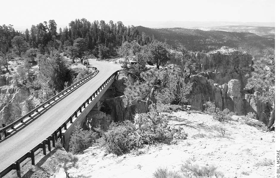
Hell’s Backbone Bridge spans a neck of land between two canyons.
Hell’s Backbone Road reaches an elevation of 9,200 feet on the slopes of Roger Peak before descending to a bridge. Mule teams used this narrow ridge, with sheer canyons on either side, as a route to Boulder until the 1930s. At that time, a bridge built by the Civilian Conservation Corps allowed the first vehicles to make the trip.
To reach Hell’s Canyon Road from Escalante, turn north on 300 East and follow the initially paved road out of town. The bridge is about 25 miles from town. Alternatively, you can turn onto Hell’s Backbone Road three miles south of Boulder on Highway 12. From this corner, the bridge is 13 miles.
Cars can usually manage the gravel and dirt road when it’s dry. Snows and snowmelt, however, block the way in winter until about late May. Check with the Escalante Interagency Visitor Center (755 W. Main St., Escalante, 435/826-5499, 8am-4:30pm daily mid-Mar.-mid-Nov., 8am-4:30pm Mon.-Fri. mid-Nov.-mid-Mar.) for current conditions. Trails and rough dirt roads lead deeper into the backcountry to more vistas and fishing lakes.
Amid aspen and ponderosa pines, Posey Lake (elevation 8,700 feet) is stocked with rainbow and brook trout. The adjacent Posey Lake Campground (Memorial Day-mid-Sept., $10) has drinking water. A hiking trail (two miles round-trip) begins near space number 14 and climbs 400 feet to an old fire-lookout tower, with good views of the lake and surrounding country. Posey Lake is 14 miles north of Escalante, and then two miles west on a side road.
Blue Spruce Campground ($8) is another pretty spot at an elevation of 7,860 feet, but it has only six sites. Anglers can try for pan-size trout in a nearby stream. The campground, surrounded by blue spruce, aspen, and ponderosa pine, has drinking water Memorial Day-mid-September; go north 19 miles from town, then turn left and drive 0.5 miles.
About 180 people live in this farming community at the base of Boulder Mountain. Ranchers began drifting in during the late 1870s, although not with the intent to form a town. By the mid-1890s, Boulder had established itself as a ranching and dairy center. Remote and hemmed in by canyons and mountains, Boulder remained one of the last communities in the country to rely on pack trains for transportation; motor vehicles couldn’t drive in until the 1930s. Today Boulder is worth a visit to see an excavated Anasazi village and the spectacular scenery along the way.
You wouldn’t expect to find one of Utah’s nicest places to stay in tiny Boulder, but the M Boulder Mountain Lodge (Hwy. 12, 435/355-7460 or 800/556-3446, www.boulder-utah.com, $130-200, discounts outside high season), along the highway right in town, offers the kinds of facilities and setting that make this one of the few destination lodgings in the state. The lodge’s buildings are grouped around the edge of a private 15-acre pond that serves as an ad hoc wildlife refuge. You can sit on the deck or wander paths along the pond, watching and listening to the amazing variety of birds that make this spot their home. The guest rooms and suites are in a handsome and modern Western-style lodge facing the pond; guest rooms are nicely decorated with quality furniture and bedding, and there’s a central great room with a fireplace and library and a large outdoor hot tub. One of Utah’s best restaurants, Hell’s Backbone Grill (435/355-7460 or 800/556-3446, 7am-11:30am and 5:30pm-9:30pm daily), is on the premises.
More modest accommodations are available at Pole’s Place (435/335-7422 or 800/730-7422, www.boulderutah.com/polesplace, spring-fall, $80), across the road from Anasazi State Park. It has a well-maintained motel, café, and gift shop.
Cowboy up at the Boulder Mountain Guest Ranch (3621 Hells Backbone Rd., 435/355-7480, http://bouldermountainguestranch.com), seven miles from Boulder on Hell’s Backbone Road. Guests have a choice of simple bunk rooms with shared baths ($70) and queen-bed guest rooms with private baths ($80-105) in the main lodge, or in free-standing cabins ($95-115) with basic kitchen facilities and private baths. Also in the lodge is the Sweetwater Café, which offers guests a variety of dining plans; nonguests are welcome at dinner (seatings 6:30, 7:15, and 8pm daily, $16-30) but reservations are required. Recreation options include daily trail rides, fly-fishing, multiday horse-packing trips, and 2-5-day riding and lodging packages based at the ranch.
The best bet for tent campers is Deer Creek Campground (year-round, $4), 6.5 miles from Boulder on Burr Trail Road; bring your own drinking water. During the summer, another alternative is to head north on Highway 12 up Boulder Mountain to a cluster of Fishlake National Forest campgrounds—Singletree (www.recreation.gov, $10), Pleasant Creek ($9), and Oak Creek ($9). In town, RV campers can stay at the Boulder Exchange (425 N. Hwy. 12, 435/335-7304, Apr.-Nov., $16 tents, $24 RVs), next to Anasazi State Park.
Hell’s Backbone Grill, one of southern Utah’s finest restaurants
The Boulder Mountain Lodge restaurant, M Hell’s Backbone Grill (Hwy. 12, 435/355-7460 or 800/556-3446, 7am-11am, noon-2pm, and 5pm-9pm daily mid-Mar.-Nov., noon-2pm daily Dec.-mid-Mar., $17-37) has gained something of a cult following across the West. Run by two American Buddhist women, the restaurant has a menu that changes with the seasons, but you can count on finding fresh fish, chipotle-rubbed meat, outstanding meatloaf, tasty posole, and excellent desserts. For simpler but good fare, the Burr Trail Grill (10 N. Hwy 12, 435/335-7432, www.burrtrailgrill.com, 11:30am-9:30pm daily Apr.-Oct. $8-18) is at the intersection of Highway 12 and Burr Trail Road. The atmospheric dining room, sided with weathered wood planking and filled with whimsical art, offers sophisticated soup and sandwiches for lunch and dinner main courses such as grilled pork loin, steaks, chicken, and trout, all with subtle Southwestern spicing.
A good stop for visitor information is the Anasazi State Park Museum (460 N. Hwy. 12, 435/335-7308, http://stateparks.utah.gov, 8am-6pm daily Apr.-Oct., 9am-5pm Mon.-Sat. Nov.-Mar.), where there’s an info desk for the GSENM. The two gas stations in Boulder sell groceries and snack food; at Hills and Hollows Mini-Mart (on the hill above Hwy. 12, 435/335-7349), you’ll find provisions as diverse as soy milk and organic cashews.
Take paved Highway 12 either through the canyon and slickrock country from Escalante or over the Aquarius Plateau from Torrey, near Capitol Reef National Park. Burr Trail Road connects Boulder with Capitol Reef National Park’s southern district via the Waterpocket Fold and Circle Cliffs. A fourth way in is from Escalante on the dirt Hell’s Backbone Road, which comes out three miles west of Boulder at Highway 12.
Utah Highway 12 climbs high into forests of ponderosa pine, aspen, and fir on Boulder Mountain between the towns of Boulder and Torrey. Travel in winter is usually possible, although heavy snows can close the road. Viewpoints along the drive offer sweeping panoramas of Escalante canyon country, the Circle Cliffs, the Waterpocket Fold, and the Henry Mountains. Hikers and anglers can explore the alpine country of Boulder Mountain and seek out the 90 or so trout-filled lakes. The Great Western Trail, which was built with ATVs in mind, runs over Boulder Mountain to the west of the highway. The Fishlake National Forest map (Teasdale District) shows the back roads, trails, and lakes.
The U.S. Forest Service has three developed campgrounds about midway along Boulder Mountain Scenic Drive: Oak Creek (18 miles from Boulder, elevation 8,800 feet, $8), Pleasant Creek (19 miles from Boulder, elevation 8,600 feet, $9), and Singletree (24 miles from Boulder, elevation 8,200 feet, www.recreation.gov, $10)—the largest of the three and the best pick for larger RVs. The season runs about late May-mid-September with water available; the campgrounds may also be open in spring and fall without water. Lower Bowns Reservoir (elevation 7,000 feet) has primitive camping (no water, free) and fishing for rainbow and cutthroat trout; turn east and go five miles on a rough dirt road (not recommended for cars) just south of Pleasant Creek Campground.
Contact the Teasdale Ranger District Office (138 S. Main St., Loa, 435/425-3702) for information about camping or recreation on Boulder Mountain.
Striking scenery surrounds this small town in Utah’s far south. The Vermilion Cliffs to the west and east glow with a fiery intensity at sunrise and sunset. Streams have cut splendid canyons into surrounding plateaus. The Paiutes knew the spot as kanab, meaning “place of the willows,” and the trees still grow along Kanab Creek. Mormon pioneers arrived in the mid-1860s and tried to farm along the unpredictable creek. Irrigation difficulties culminated in the massive floods of 1883, which gouged a section of creek bed 40 feet below its previous level in just two days. Ranching proved better suited to this rugged and arid land.
Hollywood discovered this dramatic scenery in the 1920s and has filmed more than 150 movies and TV series here since. Famous films shot hereabouts include movies as varied as My Friend Flicka, The Lone Ranger, and The Greatest Story Ever Told. The TV series Gunsmoke and F Troop were shot locally. Film crews have constructed several Western sets near Kanab, but most are on private land and are difficult to visit. The Paria set, east of town, is on BLM land and open to the public.
While most park visitors see Kanab (population 3,500) as a handy stopover on trips to Bryce, Zion, and Grand Canyon National Parks and the southern reaches of the GSENM, a few interesting sites around town warrant more than a sleep-eat-dash visit. Despite the presence of strongly conservative elements in the area—if, while exploring Kanab, you see what looks like a family reunion, it might be just a man and his wives from the nearby polygamist settlement of Colorado City or Hildale—there’s a pleasantly alternative vibe in the town itself.
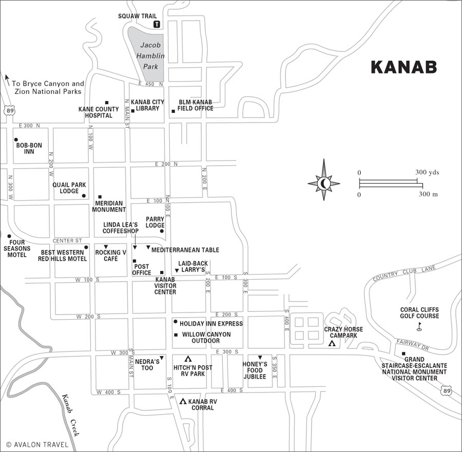
The natural Moqui Cave (U.S. 89, 5 miles north of Kanab, 435/644-8525, 9am-7pm Mon.-Sat. Memorial Day-Labor Day, 10am-4pm Mon.-Sat. Labor Day-Memorial Day, $5 adults, $4.50 seniors, $3.50 ages 13-17, $3 ages 6-12) has been turned into a tourist attraction with a large collection of Native American artifacts. Most of the arrowheads, pottery, sandals, and burial items on display have been excavated locally. A diorama recreates an Anasazi ruin located five miles away in Cottonwood Wash. Fossils, rocks, and minerals are exhibited as well, including what’s claimed to be one of the largest fluorescent mineral displays in the country. There’s even a Prohibition-era speakeasy. The collections and a gift shop are within a spacious cave that stays pleasantly cool even in the hottest weather.
• Distance: 1.5 miles one-way
• Duration: 2 hours
• Elevation change: 800 feet
• Effort: moderate
• Trailhead: north end of 100 East, near the city park
This well-graded trail provides a close look at the geology, plantlife, and animals of the Vermilion Cliffs just north of town. To cut the hike down by one mile and cut the elevation gain in half, turn around at the first overlook, where views to the south take in Kanab, Fredonia, Kanab Canyon, and the vast Kaibab Plateau. At the top, look north to see the White, Gray, and Pink Cliffs of the Grand Staircase. Pick up a trail guide at the Kanab Visitor Center (745 E. U.S. 89, Kanab, 435/644-1300, 8am-4:30pm daily). Brochures may also be available at the trailhead. Bring water with you, and in summer, try to get a very early start.
Kanab is central to an amazing number of sights, and if you’d like the pros to handle the logistics of your visit, turn to Dreamland Safari Tours (435/644-5506, www.dreamlandtours.net).
In summer, free musical concerts are held at the city park gazebo at the center of town. Every Wednesday is an ongoing local talent show. The GSENM office (435/644-4680, www.blm.gov/ut) sponsors regular ranger talks through the spring. A unique Kanab event is the Greyhound Gathering (435/644-2903, www.greyhoundgang.com, mid-May most years), when hundreds of greyhound owners converge on the town. Events include a parade, a race, and a howl-in. The Greyhound Gang, a nonprofit organization dedicated to the rescue, rehabilitation, and adoption of former racing greyhounds, hosts this unlikely festival.
Find a good selection of books, camping gear, and clothing, along with a little coffee bar, at Willow Canyon Outdoor (263 S. 100 E., 435/644-8884, www.willowcanyon.com). Terry’s Cameras (19 W. Center St., 435/644-5981, www.utahcameras.com) supplies film and camera needs, including repairs for film cameras, beyond what you would expect in a town of this size. The shop almost qualifies as an antique camera museum.
Denny’s Wigwam (78 E. Center St., 435/644-2452, www.dennyswigwam.com) is a landmark Old West trading post with a broad selection of Western jewelry, cowboy hats and boots, and souvenirs.
Most of the lodgings in Kanab are in modest family-run motels. Reservations are a good idea during the busy summer months. All of the motels and campgrounds are on U.S. 89, which follows 300 West, Center, 100 East, and 300 South through town.
The Sun-N-Sand Motel (347 S. 100 E., 435/644-5050 or 800/654-1868, $45-75) has a pool, included continental breakfast, kitchenettes, and very welcoming owners.
The Bob-Bon Inn (236 U.S. 89 N., 435/644-5094, http://bobboninn.com, $79-109) is a renovated family-run motel with pleasant log cabin-style guest rooms, fridges and microwaves in all guest rooms, plus an outdoor pool and breakfast included.
One place in Kanab that varies from the usual motor-court formula is the Parry Lodge (89 E. Center St., 435/644-2601 or 800/748-4104, www.parrylodge.com, $70-120). Built during Kanab’s heyday as a movie-making center, the Parry Lodge was where the stars stayed; 60 years later, this is still a pleasantly old-fashioned place to spend the night, and it has lots of character. At the very least you’ll want to stroll through the lobby, where lots of photos of the celebrities who once stayed here are displayed. There are many room types, including two-bedroom units, kitchen suites, a pool, and a restaurant.
A good midrange choice is the Four Seasons Motel (36 N. 300 W., 435/644-2635, www.fourseasonskanab.com, $80-110), which has a pool and accepts pets.
North of Kanab, at Mount Carmel Junction, is another Best Western. The Best Western East Zion Thunderbird Resort (435/648-2203, www.bestwestern.com, from $107), with a pool, a nine-hole golf course, and a restaurant, is convenient if you’re heading to Zion or Bryce Canyon National Parks. All guest rooms have balconies or patios.
The guest rooms at Best Western Red Hills Motel (125 W. Center St., 435/644-2675 or 800/830-2675, www.bestwesternredhills.com, $90-125) are a step up in comfort from Kanab’s lower-priced digs. The motel has balcony rooms and a pool, and it is within a short walk of restaurants.
The M Quail Park Lodge (125 U.S. 89 N., 435/644-5094 or 866/702-8099, www.quailparklodge.com, $89-149) has a pool and accepts pets. It’s one of the nicer budget motels in town, with 50s-era kitsch as well as quality linens and toiletries.
At the center of town is the Holiday Inn Express (217 S. 100 E., 435/644-3100, www.hiexpress.com, $139-154), with large, nicely furnished guest rooms, an indoor pool and exercise facility, a business center, and a guest lounge with complimentary continental breakfast.
With many inexpensive lodging options, Kanab is a good base for exploring the region.
Especially nice if you’re traveling with a group that plans to spend several nights in Kanab are the Kanab Garden Cottages (various locations, 435/644-2020, www.kanabcottages.com). You have a choice of beautifully furnished, fully outfitted studios (3-night minimum, $79) or full-size houses (3-night minimum, $160 for 2 people), which can easily sleep up to eight and are pet-friendly. All are within walking distance of town.
Northwest of Kanab, just a few miles east of Zion National Park, are the very appealing log cabins and lodges of the Zion Mountain Ranch (E. Hwy. 9, 435/648-2555 or 866/648-2555, www.zmr.com, $179-374). The cabins all have king beds and private baths plus microwaves and fridges; family lodges offer two or three bedrooms. The setting is great, with expansive views, a buffalo herd, and a decent on-site restaurant, Chez Bison. Horseback riding and other outdoor recreation is offered.
The campground at Coral Pink Sand Dunes State Park (reservations 435/648-2800 or 800/322-3770, www.stateparks.utah.gov, $16) has restrooms with showers, paved pull-through sites, and a dump station. It’s a pleasant, shady spot, but it can hum with ATV traffic. It’s open year-round, but the water is shut off late October-Easter; winter campers must bring their own. Reservations are recommended for the busy Memorial Day-Labor Day season. The campground is about 10 miles due west of Kanab, but the two are not directly connected by a road. Reach the campground by turning west off U.S. 89 about 10 miles north of Kanab onto Hancock Road, and follow it 12 miles to the campground. The route is well-marked by signs.
Just north of the state park, the BLM maintains Ponderosa Grove Campground ($5) on the north edge of the dunes. There’s no water here. From Kanab, head eight miles north on U.S. 89, turn west on Hancock Road (between mileposts 72 and 73), and continue 7.3 miles to the campground.
The Kanab RV Corral (483 S. 100 E., 435/644-5330, www.kanabrvcorral.com, year-round, $27-30) has RV sites (no tents) with hot showers, a pool, and laundry service. The Hitch’n Post RV Park (196 E. 300 S., 435/644-2142 or 800/458-3516, www.hitchnpostrvpark.com, May-Oct., $18 tents, $25-27 RVs, $28-32 cabins) has showers. The Crazy Horse Campark (625 E. 300 S., 435/644-2782, http://crazyhorservpark.com, mid-Apr.-late Oct., $16 tents, $25 RVs) has a pool, a store, a game room, and showers.
Find the best food in town at M Rocking V Café (97 W. Center St., 435/644-8001, www.rockingvcafe.com, 11:30am-3pm and 5pm-10pm daily, dinner $18-38). The setting is casual, and the food has a modern Southwestern flair. Rocking V, which caters to both vegans and steak-lovers, pays homage to the “slow food” movement and makes everything from scratch. Be sure to check out the art gallery upstairs.
Drop by Laid-Back Larry’s (98 S. 100 E., 435/644-3636, 7:30am-7pm Thurs.-Mon.) for an espresso, smoothie, or sandwich ($3-9). Larry’s also serves as the local vegan and vegetarian grocer. Linda Lea’s Coffeeshop (4 E. Center St., 435/644-8191, 7am-2pm Mon.-Fri., 8am-noon Sat.) is another good place for espresso drinks, homemade pastries, bagels, and deli sandwiches.
If you’re hankering for a good spinach enchilada or other Mexican food, settle into the friendly Nedra’s Too (300 S. 100 E., 435/644-2030, www.nedrascafe.com, 7am-9pm Tues.-Thurs., 7am-10pm Fri.-Sat., $6-10). You’ll find excellent panini and pita sandwiches at the M Mediterranean Table (18 E. Center St., 435/644-3200, 4pm-10pm daily, $7-17), along with a handful of Greek and Italian main courses. The chef-owner lived in Greece and Italy for over a decade, and the food is authentic and tasty.
Travelers setting out into the GSENM from Kanab should note that this is the best place for many miles around to stock up on groceries. Honey’s Food Jubilee (260 E. 300 S., 435/644-5877) is a good grocery store on the way out of town to the east.
Staff members at the Kanab Visitor Center (78 S. 100 E., 435/644-5033, www.visitsouthernutah.com, 8am-8pm Mon.-Sat.) offer literature and advice for services in Kanab and travel in Kane County. The Grand Staircase-Escalante National Monument has a visitors center (745 E. U.S. 89, Kanab, 435/644-1300, 8am-4:30pm daily mid-Mar.-mid-Nov., 8am-4:30pm Mon.-Fri. mid-Nov.-mid-Mar.) on the east edge of town.
Situated on U.S. 89, Kanab is 15 miles south of Mount Carmel Junction (Hwy. 9 and U.S. 89), a total of 40 miles from Zion National Park, and just 7 miles north of the Arizona-Utah border. From Kanab, U.S. 89 continues southeast, providing access to the southern reaches of Grand Staircase Escalante National Monument and, 74 miles later, Glen Canyon Dam at Page, Arizona.
Churning air currents funneled by surrounding mountains have deposited huge sand dunes in this valley west of Kanab. The ever-changing dunes reach heights of several hundred feet and cover about 2,000 of the park’s 3,700 acres. Different areas in Coral Pink Sand Dunes State Park (reservations 435/648-2800 or 800/322-3770, www.stateparks.utah.gov, day-use $6 per vehicle, camping $16 per vehicle) have been set aside for hiking, off-road vehicles, and a campground.
From Kanab, the shortest route is to go north eight miles on U.S. 89 to Hancock Road (between mileposts 72 and 73), turn left, and travel 9.3 miles on the paved road to its end, then turn left (south) and go one mile on a paved road into the park. From the north, you can follow U.S. 89 for 3.5 miles south of Mount Carmel Junction (Hwy. 9 and U.S. 89), then turn right (south) and go 11 miles on a paved road. The back road from Cane Beds in Arizona has about 16 miles of gravel and dirt with some sandy spots; ask a park ranger for current conditions.
The canyon country surrounding the park has good opportunities for hiking and off-road-vehicle travel; the Kanab BLM office (318 N. 100 E., Kanab, 435/644-2672, 8am-4:30pm Mon.-Fri. year-round) can supply maps and information. Drivers with 4WD vehicles can turn south on Sand Springs Road (1.5 miles east of Ponderosa Grove Campground) and go one mile to Sand Springs, and another four miles to the South Fork Indian Canyon Pictograph Site, in a pretty canyon. Visitors may not enter the Kaibab-Paiute Indian Reservation, which is south across the Arizona state line, from this side.