6 The North Fork of the Sol Duc
A 9-mile backpack up the North Fork of the Sol Duc River to the end of the trail. (See map 5 Aurora Ridge. )
Trail type: Secondary.
Best season: All year.
Elevation gain: 1,890 feet.
Elevation loss: 440 feet.
Maximum elevation: 2,900 feet (shelter).
Topo maps: Mount Muller, Lake Crescent; Custom Correct Lake Crescent–Happy Lake Ridge.
Finding the trailhead: Take U.S. Highway 101 west from Lake Crescent to mile 219. Then follow Sol Duc Hot Springs Road south for 8.2 miles. The parking area is marked by a sign on the west side of the road; the trail leaves from the east side.
The Hike
This trail follows the valley of the North Fork of the Sol Duc River, which has remained undisturbed by fire and human activities for centuries. The wild and remote character of this drainage is surprising given its easy access. The trail offers pleasant hiking as far as the second ford, after which it is no longer maintained. Numerous wades across the stream are required to reach the North Fork Shelter, but beyond this point it is no great feat to bushwhack upward through the open forests of a spur ridge to connect with the Happy Lake Ridge Trail.
The trail begins by climbing over the low ridge that separates the two forks of the Sol Duc. Upon reaching the banks of the North Fork, a knee-deep ford leads the hiker among the glassy green pools and chattering riffles. Once on the far bank, the trail follows the river upstream, rising gently as it traverses a bottomland stand of moss-hung bigleaf maples. This plant community is more typical of the rain forest bottoms of the peninsula’s western rivers; it is found along the North Fork because the unique configuration of the mountains produces a pocket of moist climate here.
The trail soon finds its way to the water’s edge, which it follows as the river swirls lazily across flutes and whorls of soft bedrock. After a time the path moves inland again to enter a true rain forest of mighty conifers. (Though this area might not meet the rainfall criterion of a true rain forest, it is ecologically identical to forests on the western part of the peninsula that do.) Sitka spruce and hemlock rise from skirtlike bases that formed as the saplings put down roots around a nurse log or rotting stump. The pattern is repeated in the newest generation of trees: Hemlock seedlings carpet the deadfalls and stumps that litter the forest floor. Sword ferns and vine maples dot the understory, rounding out this ancient plant community.
A campsite occupies a grassy glade at mile 3.1, after which the path climbs onto the slopes above the valley floor. It maintains a constant height of about 100 feet above the water as it continues eastward. These well-drained hillsides, crisscrossed by mossy brooks, support a lowland forest of Douglas fir and western hemlock more typical of the eastern slope of the peninsula. The valley ultimately widens out, and tall, evenly spaced Douglas firs rise from the level benches. This even-aged stand of shade-intolerant trees indicates that a forest fire probably swept the area about 250 years ago.
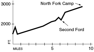
After passing a small camp on the wooded terraces, the trail begins to climb steadily and turns northeast to enter a major side valley. At mile 6.3 the path descends into a moss-lined canyon, where a tiny campsite marks the end of the maintained trail. The old trail bed fords the stream just above this spot and climbs over a hillside before dropping back to the stream. It makes innumerable fords of the creek, and it almost makes sense to hike straight up the streamcourse. The primitive trail peters out at the North Fork Shelter, which is set amid silver firs at the base of Happy Lake Ridge.
Key Points
0.0Trailhead.
1.0Knee-deep ford of North Fork of the Sol Duc River.
6.3Second ford and end of maintained trail.
9.0North Fork Shelter.