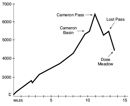
23 Cameron Pass
An extended 13.7-mile trip from Gray Wolf Camp to Dose Meadows. (See map 22 Grand Valley.)
Trail type: Foot to Cameron Basin; primitive beyond.
Best season: Late July to mid-October.
Elevation gain: 4,590 feet.
Elevation loss: 2,260 feet.
Maximum elevation: 6,450 feet (Cameron Pass).
Topo maps: Tyler Peak, Mount Angeles; Custom Correct Gray Wolf–Dosewallips.
Finding the trailhead: Taylor Cutoff Road leaves U.S. Highway 101 at mile 262, just west of Sequim. Follow it south for 2.7 miles to a junction with Fish Hatchery Road; turn right. This becomes lost Mountain Road, and after 2.8 miles, FR 2870 takes off to the left. Follow this gravel road for the remaining 6.8 miles (bearing left at junctions) to reach the marked Gray Wolf trailhead. The Cameron Pass hike begins at Gray Wolf Camp, at mile 9.8 on the Gray Wolf River Trail.
The Hike
This trail links the Gray Wolf and Dosewallips drainages, crossing Cameron and Lost Passes along the way. The grades to the passes are exceedingly steep when approached from the south, and travelers are advised to approach them from the much less strenuous northern side. This trail is well known for its late-lingering snowfields on the eastern approach to Cameron Pass, and an ice axe is often required. The trail begins at Gray Wolf Camp and runs downhill to cross a footlog over the river. It then follows the riverbank upstream to the Three Forks shelter, where a cutoff trail descends from the Deer Park auto campground. The camp occupies a grassy clearing in the gloomy forest beside the confluence of Grand and Cameron Creeks (the Gray Wolf enters some distance downstream from this point).
The Cameron Pass Trail then crosses a footlog over Grand Creek and follows the banks of Cameron Creek up into a glacier-carved valley. The path follows the streamside through a lush bottomland forest carpeted with a spongy layer of moss. It doesn’t stay there long, though. There are plenty of vigorous ups and downs to keep the traveler breathless as the trail makes periodic forays onto the hillside to avoid cut banks and washouts. A footlog spans the waters of Cameron Creek 2.1 miles above its mouth. The forest on this side of the creek receives less sunlight because of its northern exposure. As a result the closed-canopy stands are almost devoid of ground cover. When the trail returns to the northwest bank of the stream, note the vigorous growth of ferns, vanilla leaf, and trail-plant on the forest floor.
The path soon leaves the stream, climbing onto the first of many avalanche slopes that interrupt the forest from this point on. This is also the first chance to take in mountain scenery: Two sharp bulwarks of stone rise from the ridgetops across the valley. The lower spire is stout and pillarlike, while the upper one is as thin as a blade. Its triangular shape calls to mind the dorsal fin of some enormous shark, cleaving a green wave of forest. The trail continues to rise and fall as it crosses bands of timber and brushy clearings. One of the openings is occupied by the Lower Cameron shelter. Campsites are hard to come by here; campers may have to bushwhack through the tall grass to reach the creek bottom and find a spot suitable for pitching a tent.
The next major avalanche slope is 1.4 miles beyond the shelter. This opening is covered with subalpine spiraea, which bursts into lavender balls of tiny flowers in mid-July. From here hikers can look up a side valley at the summit of Mount Cameron, cradling its tiny glaciers between rocky spurs. The next broad opening allows views of the nameless peaks at the head of the valley. Just beyond its far edge, a trail descends from Grand Pass to join the Cameron Pass route. The trail then drops back to the valley floor, passing several good campsites as it follows Cameron Creek.
At the head of the valley, the trail bends gradually around to the south for the climb into Cameron Basin. Dense brushfields merge into subalpine parkland as the trail gains altitude, and nameless summits rise on all sides. The trail soon crests a rise and enters the basin, where a camping area occupies the top of a rocky knoll crowded
with sparse-limbed subalpine firs. The paths get somewhat confusing here; the main trail follows the western edge of a wet alpine meadow. The path surmounts a low headwall of rock, then turns west to cross a broad plain of broken stones. Snow lingers so late in this upper part of the basin that no plant can complete its life cycle during a single snow-free season.
Follow the cairns as the trail begins to wind up steep slopes of loose scree. The trail is constrained to a rocky crest between lingering snowfields as it climbs. The long grade ends atop Cameron Pass, which at 6,450 feet is the highest major divide served by a trail in the Olympic Mountains. The peaks rise rank on rank to the west, as numberless as waves on the sea. The distant peaks are highlighted by Mount Queets in the south, Mount Olympus in the center, and the Bailey Range in the north. Closer at hand the twin summits of Mount Claywood and Mount Fromme rear their somber heads above the basin of the Lost River. The noble summits of Mount Anderson cleave the sky beyond them, with pinnacles that guard the Eel Glacier.
Down goes the trail, following cairns through a barren waste where shrubby cinquefoils and alpine saxifrage cling tenuously to shale-covered slopes. Down farther it goes, across grassy slopes and among clumps of fir that cower as krummholz. Raptors of all kinds fill the skies, searching for the numerous rodents that in turn prey on the lush growth of grasses and forbs. The descent steepens as the trail goes downward through stands of tall firs, stately in their upright form on these more protected slopes. The path finally bottoms out in a luxuriant expanse of wet meadow that lies at the foot of Lost Peak. Marmots pipe their warning whistle in the basin. Several chuckling brooks wander through the grasslands, providing the extra moisture that is needed to sustain willows, monkeyflowers, and shooting stars.
The trail then climbs gradually through alpine parkland to reach Lost Pass. Looking south, the pointed crests of Wellesley and Sentinel Peaks guard the vast expanse of Thousand Acre Meadows. This high terrace of heath provides habitat for Roosevelt elk, black-tailed deer, and black bear. The brooding mass of Mount Claywood looms above the pass to the west. The path then dives headlong down the steep valley wall to the south, dropping through the timber at an insane rate. Watch out for loose rock that might roll underfoot; it is a serious safety hazard on pitches of this steepness. The trail deposits the traveler in Dose Meadows, where a pleasant camping spot provides a welcome respite. A trail ascends along the Dosewallips River to reach this point, and another climbs away to the southwest on its way to Hayden Pass.
Key Points
0.0 Gray Wolf Camp, junction with Gray Wolf River Trail. Bear north.
0.1 Trail crosses Gray Wolf River.
0.4 Three Forks shelter, junction with Three Forks cutoff trail. Turn left and cross Grand Creek.
2.5 Trail crosses Cameron Creek to reach its east bank.
3.6 Trail returns to northwest bank of Cameron Creek.
5.3 Lower Cameron shelter.
7.4 Junction with trail from Grand Pass. Keep going straight.
9.7 Cameron Basin camping area.
11.0 Cameron Pass.
12.1 Trail crosses headwaters of Lost River.
12.9 Lost Pass.
13.7 Junction with Dosewallips River Trail, Dose Meadows Camp.