26 The Royal Basin
A long (7-mile) day hike or backpack from Forest Road 2860 to Royal Lake. See map (25 The Upper Dungeness Trail.)
Trail type: Secondary.
Best season: Late June to mid-October.
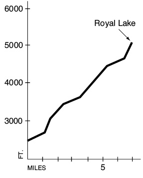
Elevation gain: 2,570 feet.
Maximum elevation: 5,120 feet (Royal Lake).
Topo maps: Tyler Peak; Custom Correct Buckhorn Wilderness.
Finding the trailhead: From Sequim, drive east on U.S. Highway 101 to mile 267.4 and turn south onto Palo Alto Road. The pavement ends after 6 miles, and the road becomes Forest Road 28. Drive another 3 miles to FR 2860. Turn left and drive 11.7 miles, avoiding Forest Road 2870, to the Upper Dungeness trailhead.
The Hike
This trail provides one of the gentlest grades to an alpine lake in the Olympic Mountains. The trek begins on the Upper Dungeness Trail, which it follows for the first mile along the noisy course of the headwaters of the Dungeness River. A dense forest of young hemlocks is underlain by a carpet of duff and moss. After 1 mile a footbridge marks the spot where the Royal Basin Trail splits off to the right, climbing gently beside the rather milky waters of Royal Creek. As the valley bends to take on a southwesterly orientation, the trail leaves the stream to wander up a series of forested benches. Undergrowth plants such as vanilla leaf and bracken fern begin to invade the understory.
At last the trail climbs into the first of several avalanche slopes that are choked with thimbleberry and ocean spray. This opening offers a fine first view of Mounts Clark and Walkinshaw. The path begins to climb steadily as the conifers become increasingly scarce. Stately silver firs, some of them quite stout, take shelter from avalanches on the rocky knobs. The trail makes its way through stands of subalpine fir and Alaska cedar on its way into the hanging upper valley of Royal Creek. In doing so, the trail passes within earshot of the roaring cataract that pours over the steep headwall.
The flat basin above is filled with subalpine vegetation: Silver and subalpine firs cluster on the higher ground, while grassy meadows and clumps of willow surround the myriad streams that wander the valley floor. Here a few blocky boulders were deposited far from their origins by the glaciers that once filled the valley. Mount Deception and its lesser companions can barely be glimpsed above the next rise, while the craggy faces of Mounts Clark and Walkinshaw tower to the west. On the opposite side of the valley, the steady slope of an arid ridge rises from fir-clad shoulders to tawny peaks. Sedge meadows near the head of the basin offer a few tent sites.
After a footlog crossing of Royal Creek, the trail makes a rocky and washed-out passage up the next rise to enter the Royal Basin. It soon arrives at Royal Lake, a tiny pool surrounded by firs and overlooked by Mounts Deception and Fricaba and a retinue of lesser snow-mantled peaks. There are a few campsites at the head of the lake and more in the meadow beyond it. Stunted brook trout cruise the waters of the lake, which are tinted green by suspended microscopic algae. The maintained trail ends at a huge overhanging boulder known as “Shelter Rock.” Beyond this point the upper part of the basin invites exploration by map and compass, featuring additional tarns, permanent snowfields, and abandoned glacial moraines.
Key Points
0.0Upper Dungeness trailhead.
1.0Junction with Royal Basin Trail. Turn right.
1.2Junction with Lower Maynard Burn way trail. Bear left.
1.5Trail enters Olympic National Park.
6.4Lower camping area
6.5Trail crosses Royal Creek to reach east bank.
7.0Royal Lake.
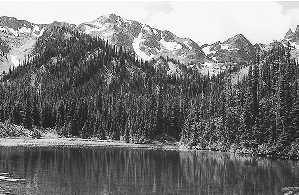
Royal Lake