28 Marmot Pass
A 7.1-mile day hike or backpack from Forest Road 2750 to the Upper Dungeness Trail. (See map 27 The Tubal Cain Trail.)
Trail type: Secondary.
Best season: Late June to mid-October.
Elevation gain: 3,580 feet.
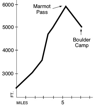
Elevation loss: 980 feet.
Maximum elevation: 5,980 feet.
Topo maps: Tyler Peak; Custom Correct Buckhorn Wilderness.
Finding the trailhead: From mile 296.1 on U.S. Highway 101 (just south of Quilcene), turn west onto Penny Creek Road. It becomes Forest Road 27, a paved, one-lane trunk route. Drive 11.2 miles from US 101 and turn left onto FR 2750 at a poorly marked junction. This dirt road splits three ways; follow the middle road 4.9 miles to the Upper Big Quilcene trailhead.
The Hike
This trail offers a brief climb to a windswept pass in the Buckhorn Wilderness. It is centrally located to connect with other trails in the area, providing longer trips to Constance Pass or the Copper Creek valley. This trail is officially known as the Upper Big Quilcene River Trail, even though the “river” is no more than a small mountain stream at these elevations. The hike begins in the mature forest that cloaks the north bank of the Big Quilcene. This small woodland brook splashes and tumbles through a gauntlet of mossy stones and fallen logs. After leaving the water’s edge, the climb stiffens and the path crosses several breaks in the forest. It is too early in the trek for mountain scenery, but showy wildflowers thrive in these patches of sunlight.
The trail approaches the stream once more at Shelter Rock Camp, named for an enormous boulder that hulks amid the trees just to the east. After passing the tent sites, the trail makes a sharp bend to the north and climbs vigorously beside a feeder stream. It then turns west again as the ascent slackens, and the montane forest is interrupted by openings that provide the first scenic views. Still climbing, the path crosses an open slope of broken basalt surrounded by spectacular scenery. Alaska cedar, ocean spray, and serviceberry grow amid the rocky waste, while Olympic daisies and mountain asters bloom on the verdant slopes beyond. Across the valley rise the towers and pinnacles of Warrior Peak, while the angular spires of Buckhorn Mountain protrude from the slopes above the trail.
The route soon crosses moister slopes clothed in elegant silver and subalpine firs, through which it climbs the final pitch to reach Camp Mystery. The tent sites are sheltered amid the firs atop a level shelf. A chuckling brook runs past the camp, providing a last reliable supply of water on the trail (be sure to treat it). The path then makes its way up through a charming vale where wildflowers thrive on the moisture provided by the rill. It then climbs around a brow of rock and enters a small, grassy bowl just below Marmot Pass. Once on top, the trail reveals the summits of the Needles rising above the ridgetops to the west: Mount Deception in the south, Mount Clark in the center, and the tip of Mount Walkinshaw just visible to the north. The rounded summits of Mounts Mystery and Fricaba rise farther to the south.
The Tubal Cain Trail descends into the pass from the north, while the Marmot Pass route departs on a southwesterly tangent. It crosses meadowy slopes splashed with clumps of wildflowers. Olympic daisies, rockslide larkspurs, spreading phlox, lupines, yarrow, and paintbrushes all intermix in a dazzling display of color that peaks in midsummer. Watch for Olympic marmots on these verdant hillsides, and keep an eye out for golden eagles that hunt along the open ridgetops. As the trail descends, the slopes become more arid, and a few whitebark pines are scattered amid broad expanses of bare ground. Magnificent views of Warrior Peak and a western spur of Mount Constance unveil themselves as the path rounds a finger ridge and begins to switchback down its spine. The trees thicken as the trail sheds altitude, finally reaching its end at a junction with the Upper Dungeness Trail, just north of the Boulder shelter.
Key Points
0.0Upper Big Quilcene trailhead.
0.1Trail enters Buckhorn Wilderness.
2.6Trail leaves valley floor near Shelter Rock.
4.6Camp Mystery.
5.3Marmot Pass. Junction with Tubal Cain Trail. Turn left.
7.1Junction with Upper Dungeness Trail.