34 Lake Constance
A 2.2-mile wilderness route to Lake Constance. (See map 33 Constance Pass.)
Trail type: Primitive.
Best season: Early June to mid-October.
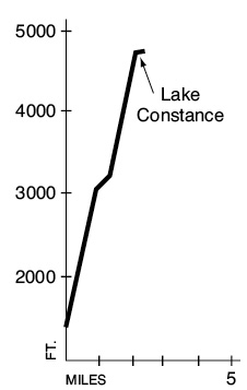
Elevation gain: 3,300 feet.
Maximum elevation: 4,750 feet.
Topo maps: The Brothers, Tyler Peak; Custom Correct Buckhorn Wilderness.
Finding the trailhead: From mile 306.1 on U.S. Highway 101 in the north part of Brinnon, turn west onto Dosewallips Road (Forest Road 2610). Drive 14 miles to the trailhead. The trail begins from a hard-to-see trail sign beside the cascade of Constance Creek.
The Hike
This “trail” is little more than a climbing route and is typified by brutal uphill pitches choked with roots and exposed boulders. Surfaces are often slippery when wet, and the route should not be attempted during rainy weather. There are campsites on the north shore of the lake that require reservations, but only a mountaineer would be crazy enough to haul a full pack up this grade. Camping is restricted to a limited number of permits, which are issued at the Dosewallips Ranger Station.
From the trailhead the route wastes no time in heading straight up the steep mountainside. It makes its way up among mature hemlocks that spread networks of exposed roots across the boulders and bedrock. Constance Creek soon disappears, leaving a stony bed beneath which the waters seek an underground passage. House-size boulders litter the forest floor. After 0.8 mile the path levels off, and the splashing of the stream can be heard once more.
The respite is brief, however, as the trail enters a narrow valley choked with brush. The trail plunges relentlessly up the cleft, following the streambank. Take a backward glance early in this pitch for a fine view of The Brothers. Upon reaching an impassable scarp of bedrock, the trail turns west to climb straight up the valley wall. Some scrambling skill is useful here as the path ascends along chinks in the basalt; travelers should keep three of their four limbs solidly on the rock at all times.
After a long and grueling ascent, the traveler arrives at the foot of Lake Constance. At this point the hiker is rewarded with dazzling views of the sheer spires of basalt that soar skyward above the turquoise waters of the lake. The main mass of Mount Constance rises above the eastern shore of the lake, while the rugged peak above its head to the west is known to climbers as “Inner Constance.” Brook trout cruise the depths, and mountain goats are frequently seen from the lakeshore. A few small tent pads occupy a stand of fir on the north shore of the lake; camping is prohibited elsewhere. Because of heavy human impacts around the lakeshore, visitors should stay on the designated trail and avoid areas marked for revegetation.
Key Points
0.0 Trailhead.
2.0 Foot of Lake Constance.
2.2 Camping area, head of lake.