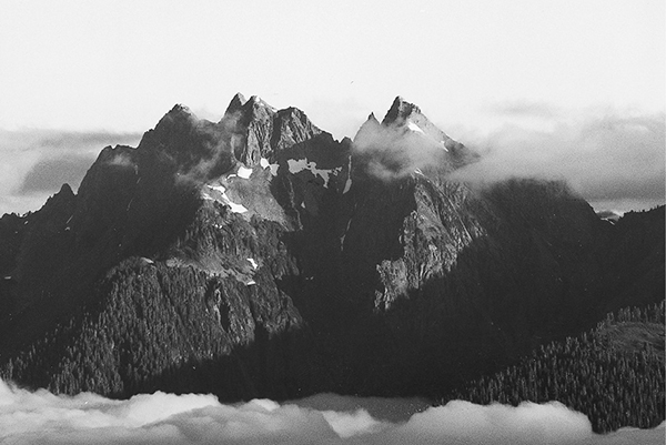
Rugged crags beyond the Queets Valley
51 The Skyline Trail
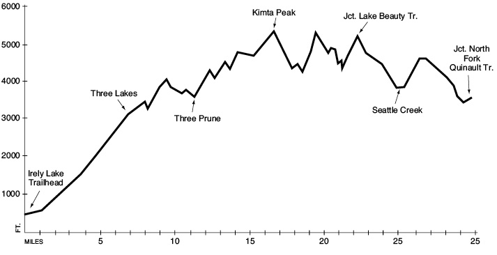
This is a 29.9-mile wilderness route from the Irely Lake trailhead to the North Fork Quinault Trail. (See map 50 The North Fork of the Quinault.)
Trail type: Foot to Three Lakes; primitive beyond.
Best season: Late July to mid-October.
Elevation gain: 9,180 feet.
Elevation loss: 6,110 feet.
Maximum elevation: 5,330 feet.
Topo maps: Bunch Lake, Kitma Peak, Mount Christie; Custom Correct Quinault–Colonel Bob.
Finding the trailhead: From U.S. Highway 101 at mile 125.5, turn east onto Lake Quinault South Shore Road. The pavement ends after 7.8 miles, and 5 miles later is a bridge over the Quinault. Turn left to cross it, and then turn right onto North Shore Road for the remaining 2.6 miles to the well-marked trailhead for Irely Lake.
The Hike
This trail offers an outstanding ridge walk along the Queets–Quinault divide, with outstanding views of the wild and remote peaks of the southwestern Olympics. The path is quite difficult to follow between Kimta Peak and Lake Beauty, and some route-finding ability is required. The Skyline Ridge Trail can be combined with the North Fork of the Quinault for a loop trip of five to six days.
The trail begins in the rain forest river bottoms of the Quinault’s North Fork. It runs northward among the stout trunks of old-growth red cedar and Sitka spruce, climbing in short bursts across the forested benchlands. Ferns and mosses grow from every available surface, suffusing the landscape with green. After 0.7 mile the trail crosses tiny Irely Creek and begins to follow its meandering, brush-choked channel. Salmonberries and thimbleberries grow side by side here, and are soon joined by a profusion of red huckleberries on the benches overlooking Irely Lake. This large rain forest pool is surrounded by wet meadows, forming a rare and important pocket of wetland in the midst of the conifers. Ospreys, waterfowl, and beavers are commonly seen at the lake and the surrounding marshes. There is a primitive camping area at the north end, but mosquitoes here are known to be fierce.
The main trail skirts the eastern side of the lake, then climbs aggressively as it makes its way into the valley of Big Creek. The path clings to the steep slopes several hundred feet above the stream as the forest steadily takes on a more montane character. Ferns and wood sorrel still abound in the understory, however, reminding the traveler that even the high slopes receive ample rainfall. The trail parallels Big Creek for 2.5 miles, then crosses it at an elaborate footbridge that arches gracefully above the mossy pools and rushing chutes. The trail then climbs steeply away from the stream on its way up the western wall of the valley.
The ascent slackens a bit as the route bends westward to enter a broad, shallow basin. Along the way a signpost marks the location of the largest Alaska cedar tree ever recorded. The forest begins to open up into wet meadows and brushfields interspersed with stands of mountain hemlock and Alaska cedar. Sedges and cottongrass occupy the water-soaked swales, while a dense growth of blueberry bushes adorns the well-drained hillocks. At the head of the valley, the trail reaches the Three Lakes camping area, situated beside a large pond and surrounded by open meadows. The abandoned Tshletshy Creek Trail is discernible as it breaks away to the west, while the Skyline Ridge Trail turns north.
After crossing the headwaters of Big Creek, the path begins to descend gradually through the montane forest. It passes a tiny pond, rises through the forest obscuring nearby Reflection Lake, then crosses the almost imperceptible divide into the Elip Creek drainage. At this open and windswept spot, a broad expanse of heather allows outstanding views of the ranges to the east. The rugged crag rising from the wooded ridges due east is Mount Lawson, and Muncaster Mountain rises to a sharp point beyond the U-shaped valley of Rustler Creek.
The trail passes several gemlike pools set among the rolling meadows of the upper Elip basin, then climbs the spur ridge to the north. The first glimpse of Mount Olympus can be had atop this divide. The trail then makes a brief but rather steep descent through a loose-knit subalpine forest, then begins to follow the contours around the head of the Three Prune drainage. The Elip Creek cutoff trail soon joins the Skyline route, and 1.5 miles later the trail arrives at Three Prune Camp. This spot occupies a collection of open knolls in the northeast corner of the basin and commands views of Muncaster Mountain. Elephant’s head blooms amid the cottongrass of the low spots; the drier ground is lit by the bulblike blossoms of beargrass.
Rugged crags beyond the Queets Valley
The trail then begins to climb through heavy timber, passing above the headwaters of Stalding Creek. The trees thin out here, and the path follows the ridgetop northward. On two occasions the trail crosses over the ridgeline to pass west of high points; the second of these west-facing hillsides sports an open meadow that looks out over the forested drainage of Alta Creek. The next pass is covered in open fellfield, where late-blooming wildflowers brave lingering snowdrifts to bring color to the high country. The slopes beyond this pass are dotted with clumps of ancient mountain hemlocks. In this part of the range, timberline is determined not by cold or wind but by patterns of lingering snow; seedlings that take root on raised knolls where the snow melts early can be expected to grow rapidly.
The next open slope marks the ascent of Kimta Peak. The path climbs steeply through the flowery meadow, and hikers must face bushy hemlock saplings that contest the right-of-way. The trail stops climbing just below the western summit of the mountain, then begins a long descent across open slopes dissected by a number of rushing rivulets. After quite some time the trail enters a swampy forest, where the path grows faint beneath a dense growth of tall grasses. This forest soon gives way to the stark, skeletal snags of the Kimta Peak burn. This fire razed 177 acres of timber in 1987. The trail is difficult to detect as it crosses the fire-scarred landscape; look for flagging and sawed deadfalls.
On the far side of the burn, the trail embarks on one of the great killer grades in the park. This incredibly steep path ends at a high pass at the head of the Promise Creek drainage. A primordial rockscape of tilted phyllite shot through with veins of quartz stretches broadly to encompass the entire headwaters area. Follow the cairns uphill to the north as the path fades to an indistinct route across bare bedrock and scree. Mount Seattle dominates the northern skyline, while a nameless crag guards the eastern approaches to Promise Creek. After nearing the ridgetop, travelers should follow cairns on a long downhill arc. The descent ends where the rock is covered with trees and meadows; here the trail climbs and drops dramatically as it picks its way among the vertically tilted strata that block its path. Excellent views of Mount Christie open up before the trail climbs into a pass above the head of Hee Haw Creek.
The steady descent continues across the western side of the ridge, where open slopes allow outstanding views of Mount Olympus and the crags that trail away to the west of it. These peaks are nameless, but mountaineers call them “The Valhallas.” The next saddle in the ridgetop is riven so deeply by erosion that the uplifted sheets of bedrock rise from the soil like bared bones. The junction with the Lake Beauty Trail lies at the northern edge of this pass. This path descends steeply for 0.3 mile to reach a campsite beside the lake. The water is tinted such that the deeper parts appear dark blue, while the shallows are a shade of turquoise. The meadowy hummocks surrounding the lake offer fine views of the Olympus massif across the deep Queets Valley, which is often filled with low clouds.
The main trail jogs east from the rocky saddle, maintaining its altitude with a series of gentle rises and descents. As the trail rounds a bend in the hillside, the sparsely forested slopes give way to meadowy benches that hold a scattering of ponds and rivulets. These meadows provide the picturesque foreground for the towering rock mass of Mount Seattle, which rises above the head of Seattle Creek along with its companion peak, Mount Noyes. After departing the high benchlands, the trail begins a gradual descent into the valley, then switchbacks downward through the trees at a more workmanlike pace. Near the bottom of the grade, the path traverses northeast once more, paralleling the meadowy course of Seattle Creek. The creek bottoms possess a subalpine character due to the snows that linger here into the summer, creating a sort of reverse timberline.
After a boulder hop across the rushing waters, the trail begins to climb the forested east wall of the valley. It switchbacks high onto the shoulders of Mount Seattle, where rolling country is covered with heather and blueberry bushes. After rounding the corner into the North Fork Quinault valley, the trail maintains its altitude to pass through rocky forest openings. The rocky spires of Mount Christie rise sheer above the deep trench carved over the course of millennia by glaciers. The trail soon zigzags down through the timber, then turns northeast to parallel the course of the North Fork. After 0.5 mile it reaches a junction with the North Fork Quinault Trail in a meadow just below the Low Divide Ranger Station.
Key Points
0.0Irely Lake trailhead.
0.7Trail crosses Irely Creek.
1.1Spur path to Irely Lake.
4.0Trail crosses Big Creek.
6.0Trail passes record Alaska cedar.
7.0Three Lakes Camp. Junction with abandoned Tshletshy Creek Trail. Turn right.
8.9Trail crosses divide into Elip Creek drainage.
9.6Trail enters Three Prune drainage.
9.9Junction with Elip Creek cutoff trail. Stay left.
11.4Three Prune Camp.
12.6Trail crosses divide into Stalding Creek drainage.
17.0Trail passes Kimta Peak.
19.3Trail enters Promise Creek basin.
22.5Junction with spur to Lake Beauty. Through hikers bear right.
25.5Trail fords Seattle Creek.
29.9Junction with North Fork Quinault Trail.