Uxmal
Uxmal, pronounced oosh-mahl, is an impressive set of ruins, easily ranking among the top (and unfortunately most crowded) Maya archaeological sites. It is a large site with some fascinating structures in good condition and bearing a riot of ornamentation. Adding to its appeal is Uxmal’s setting near the hilly Puuc region, which lent its name to the architectural patterns in this area. Puuc means ‘hills,’ and these, rising up to about 100m, are the first relief from the flatness of the northern and western portions of the peninsula.
For an additional cost, Uxmal projects a nightly light-and-sound show.
For an entirely different experience, outside the ruins, the Choco-Story (www.choco-storymexico.com; Hwy 261 Km 78, near Hotel Hacienda Uxmal; adult/child 6-12yr M$120/90; ![]() h9am-7:30pm) museum takes a look at the history of chocolate.
h9am-7:30pm) museum takes a look at the history of chocolate.
1Sights
Exploring the Ruins
Casa del AdivinoARCHAEOLOGICAL SITE
(Pirámide del Adivino)
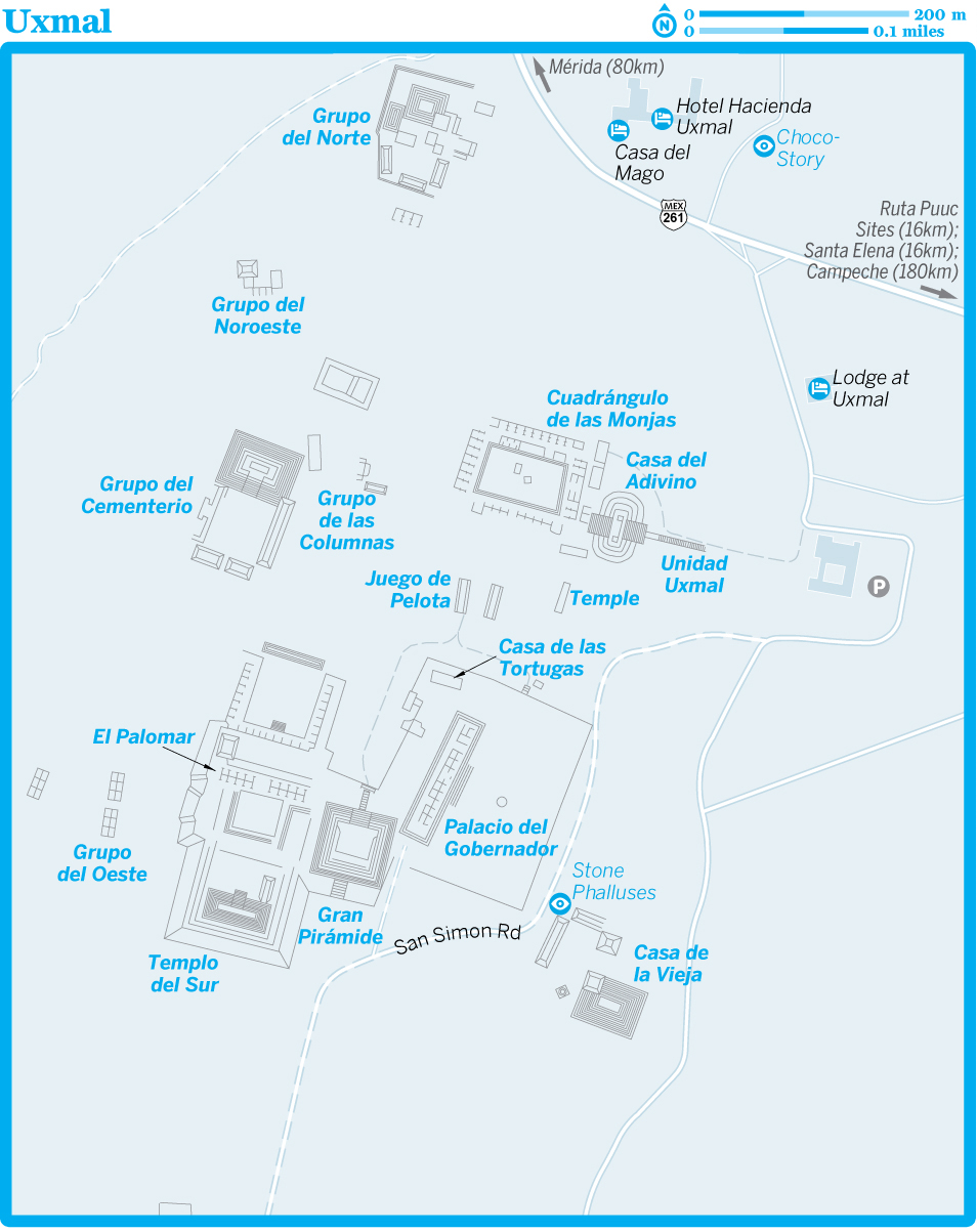
As you approach Uxmal, the Casa del Adivino comes into view. This 35m-high temple (the name translates as ‘Magician’s House’) was built in an unusual oval shape. What you see is a restored version of the temple’s fifth incarnation, consisting of round stones held rudely together with lots of cement. Four earlier temples were completely covered in the final rebuilding by the Maya, except for the high doorway on the west side, which remains from the fourth temple.
Decorated in elaborate Chenes style (a style that originated further south), the doorway proper forms the mouth of a gigantic Chaac mask.
Cuadrángulo de las MonjasARCHAEOLOGICAL SITE
The 74-room, sprawling Nuns’ Quadrangle is directly west of the Casa del Adivino. Archaeologists guess variously that it was a military academy, royal school or palace complex. The long-nosed face of Chaac appears everywhere on the facades of the four separate temples that form the quadrangle. The northern temple, the grandest of the four, was built first, followed by the southern, then the eastern and finally the western.
Several decorative elements on the exuberant facades show signs of Mexican, perhaps Totonac, influence. The feathered-serpent (Quetzalcóatl, or in Maya, Kukulcán) motif along the top of the west temple’s facade is one of these. Note also the stylized depictions of the na (traditional Maya thatched hut) over some of the doorways in the northern and southern buildings.
Passing through the corbeled arch in the middle of the south building of the quadrangle and continuing down the slope takes you through the Juego de Pelota (Ball Court). From here you can turn left and head up the steep slope and stairs to the large terrace. If you have time, you could instead turn right to explore the western Grupo del Cementerio (which, though largely unrestored, holds some interesting square blocks carved with skulls in the center of its plaza), then head for the stairs and terrace.
Casa de las TortugasARCHAEOLOGICAL SITE
The House of the Turtles, which you’ll find south of the Juego de Pelota (Ball Court), takes its name from the turtles carved on the cornice. The Maya associated turtles with the rain god, Chaac. According to Maya myth, when the people suffered from drought, so did the turtles, and both prayed to Chaac to send rain.
The frieze of short columns, or ‘rolled mats,’ that runs around the temple below the turtles is characteristic of the Puuc style.
On the west side of the building a vault has collapsed, affording a good view of the corbeled arch that supported it.
Palacio del GobernadorARCHAEOLOGICAL SITE
The Governor’s Palace, with its magnificent facade nearly 100m long, is arguably the most impressive structure at Uxmal. The buildings have walls filled with rubble, faced with cement and then covered in a thin veneer of limestone squares; the lower part of the facade is plain, the upper part festooned with stylized Chaac faces and geometric designs, often lattice-like or fretted.
Other elements of Puuc style are decorated cornices, rows of half-columns (as in the Casa de las Tortugas) and round columns in doorways (as in the palace at Sayil).
Researchers recently discovered some 150 species of medicinal plants growing on the east side of the palace. Due to the high concentration of plants growing there it’s believed they were cultivated by the Maya to treat stomach infections, snake bites and many other ailments.
Gran PirámideARCHAEOLOGICAL SITE
The 30m-high, nine-tiered pyramid has been restored only on its northern side. Archaeologists theorize that the quadrangle at its summit was largely destroyed in order to construct another pyramid above it. That work, for reasons unknown, was never completed. At the top are some stucco carvings of Chaac, birds and flowers.
El PalomarARCHAEOLOGICAL SITE
West of the Gran Pirámide sits a structure whose roofcomb is latticed with a pattern reminiscent of the Moorish pigeon houses built into walls in Spain and northern Africa – hence the building’s name, which means the Dovecote or Pigeon House. Honeycombed triangular ‘belfries’ sit on top of a building that was once part of a quadrangle.
Casa de la ViejaARCHAEOLOGICAL SITE
(Old Woman’s House)
Off the southeast corner of the Palacio del Gobernador’s platform is a small complex, now largely rubble, known as the Casa de la Vieja. In front of it is a small palapa (thatch-roof shelter) that covers several large phalluses carved from stone.
4Sleeping
There is no town at Uxmal, only several hotels, and there are no budget options. A good range of midrange lodgings can be found in Santa Elena, 16km southeast, or in Ticul, 30km east.
Hotel Hacienda UxmalHISTORIC HOTEL$$$
(![]() %800-719-54-65, USA 877-240-58-64; www.mayaland.com; Hwy 261 Km 78; r from US$136;
%800-719-54-65, USA 877-240-58-64; www.mayaland.com; Hwy 261 Km 78; r from US$136; ![]() p
p![]() a
a![]() W
W![]() s)
s)
This attractive Mayaland Resort is 500m from the ruins. It housed the archaeologists who explored and restored Uxmal. Wide, tiled floors, lots of wrought iron, high ceilings, great bathrooms and a beautiful swimming pool make for a pleasant stay. There are even rocking chairs to help you kick back after a hard day of exploring.
For those on a budget, the attached Casa del Mago may have cheaper rooms but was closed for unknown reasons at the time of research.
Lodge at UxmalLUXURY HOTEL$$$
(![]() %800-719-54-65, USA 877-240-58-64; www.mayaland.com; Hwy 261 Km 78; r from US$235;
%800-719-54-65, USA 877-240-58-64; www.mayaland.com; Hwy 261 Km 78; r from US$235; ![]() p
p![]() a
a![]() W
W![]() s)
s)
Rooms could be nicer for the price, but you can’t beat the easy access to the ruins and the pool certainly adds value. Some of the more expensive rooms have Jacuzzis. We don’t suppose Stephens and Catherwood enjoyed such luxury when they passed through the area in the late 1830s.
8Getting There & Away
Uxmal is 80km from Mérida. Departures (around M$70, 1½ hours, four daily) on the Sur bus line leave from Mérida’s Terminal TAME. But going back to Mérida, passing buses may be full. If you get stuck, a taxi to nearby Santa Elena costs M$150 to M$200.
Tours offered by Nómadas Hostel in Mérida are always a good option, or rent a car and also visit other ruins in the area.

Santa Elena
![]() %997 / Pop 3500
%997 / Pop 3500
Originally called Nohcacab, the town known as Santa Elena today was virtually razed in 1847 in the Caste War. ‘Ele-na’ means burnt houses in Maya. The Mexican government changed the name to Santa Elena in a bold PR stunt.
If you’re up for a little DIY adventure, head 4km outside town to the Mulchic pyramid; locals can tell you how to get there.
Santa Elena makes a great base to explore the nearby ruins of Uxmal, Kabah and those along the Ruta Puuc.
1Sights
Santa Elena MuseumMUSEUM
(M$10; ![]() h9am-6pm)
h9am-6pm)
The only reason you go to this tiny museum is for the view (it’s perched on a hill) and to support the locals – both worth doing. As for the displays? While they are termed ‘18th-century child mummies,’ in truth they are four sub-composed bodies that were found buried beneath the adjoining cathedral.
4Sleeping & Eating
![]() oPickled OnionB&B$$
oPickled OnionB&B$$
(![]() %cell 997-1117922; www.thepickledonionyucatan.com; off Hwy 261; d/f incl breakfast from US$50/65;
%cell 997-1117922; www.thepickledonionyucatan.com; off Hwy 261; d/f incl breakfast from US$50/65; ![]() p
p![]() n
n![]() W
W![]() s)
s)
Offers the chance to stay in a modern adobe-walled hut with lovely tiled floors and bathrooms. The well-maintained rooms all come with coffee makers and mosquito netting and keep you cool with palapa roofs. We love the pool and surrounding lush and landscaped gardens, and the excellent restaurant (mains M$110-120; ![]() h7:30am-8:30pm;
h7:30am-8:30pm; ![]() p
p![]() W) does food to go for picnics in the nearby ruins. It’s on the south end of town, off Hwy 261.
W) does food to go for picnics in the nearby ruins. It’s on the south end of town, off Hwy 261.
Nueva AltiaB&B$$
(![]() %cell 998-2190176; Hwy 261 Km 159; d incl breakfast US$66;
%cell 998-2190176; Hwy 261 Km 159; d incl breakfast US$66; ![]() p
p![]() n
n![]() W)
W) ![]() S
S
If you’re looking for some peace and quiet, this is the place. Geometrically designed to get nice cross breezes, the spiral-shaped bungalows were inspired by ancient Maya architecture. And, as with many locales, unearthed Maya ruins are tucked away on the pretty, wooded grounds.
Flycatcher InnB&B$$
(![]() %997-978-53-50; www.flycatcherinn.com; off Hwy 261; d incl breakfast from M$1200-1800;
%997-978-53-50; www.flycatcherinn.com; off Hwy 261; d incl breakfast from M$1200-1800; ![]() hmid-Oct–Aug;
hmid-Oct–Aug; ![]() p
p![]() a
a![]() W)
W)
Flycatcher Inn features seven squeaky-clean rooms, all with great porches, hammocks, excellent screenage and spiffy bathrooms. It is surrounded by a pleasant garden and a number of bird and animal species can be seen here, including the flycatchers that gave their name to the place.
The inn’s driveway is less than 100m north of Santa Elena’s southern entrance, near Restaurant El Chac-Mool (![]() %997-978-51-17; www.facebook.com/chacmooluxmal; Calle 18 No 211B; mains M$110-120;
%997-978-51-17; www.facebook.com/chacmooluxmal; Calle 18 No 211B; mains M$110-120; ![]() h7am-10pm;
h7am-10pm; ![]() p
p![]() W).
W).
8Getting There & Away
It’s handy to have your own wheels here, especially if you’re using it as a base to visit the ruins of Uxmal, plus to explore the Ruta Puuc. Second-class Sur Mayab buses run between Mérida and Campeche stopping in Uxmal and Santa Elena (plus Oxcutzcab, five daily, around M$70).
Kabah
KabahARCHAEOLOGICAL SITE
(Hwy 261; M$50, guides M$500; ![]() h8am-5pm)
h8am-5pm)
On entering, head right to climb the stairs of El Palacio de los Mascarones (Palace of the Masks). Standing in front of it is the Altar de los Glifos, whose immediate area is littered with many stones carved with glyphs. The palace’s facade is an amazing sight, covered in nearly 300 masks of Chaac, the rain god or sky serpent. Most of their huge noses are broken off; the best intact beaks are at the building’s south end.
These curled-up noses may have given the palace its modern Maya name, Codz Poop (Rolled Mat; it’s pronounced more like ‘Codes Pope’ than some Elizabethan curse). This section was recently restored.
When you’ve had your fill of noses, head north and around to the back of the Poop to check out the two restored atlantes (an atlas – plural ‘atlantes’ – is a male figure used as a supporting column). These are especially interesting, as they’re some of the very few 3D human figures you’ll see at the main Maya sites. One is headless and the other wears a jaguar mask atop his head.
Descend the steps near the atlantes and turn left, passing the small Pirámide de los Mascarones, to reach the plaza containing El Palacio. The palace’s broad facade has several doorways, two of which have a column in the center. These columned doorways and the groups of decorative columnillas (little columns) on the upper part of the facade are characteristic of the Puuc architectural style.
Steps on the north side of El Palacio’s plaza put you on a path leading about 200m through the jungle to the Templo de las Columnas, which has more rows of decorative columns on the upper part of its facade. At last visit, access to the temple was closed for restoration.
West of El Palacio, across the highway, a path leads up the slope and passes to the south of a high mound of stones that was once the Gran Pirámide (Great Pyramid). The path curves to the right and comes to a large restored monumental arch. It’s said that the sacbé, or cobbled and elevated ceremonial road, leading from here goes through the jungle all the way to Uxmal, terminating at a smaller arch; in the other direction it goes to Labná. Once, all of the Yucatán Peninsula was connected by these marvelous ‘white roads’ of rough limestone.
At present nothing of the sacbé is visible, and the rest of the area west of the highway is a maze of unmarked, overgrown paths leading off into the jungle.
The souvenir ticket office sells snacks and cold drinks. For good lodging, stay in Santa Elena, about 8km north of Kabah.
Kabah is 104km from Mérida. It’s easiest to reach the site by car, or from Mérida you can take a Sur bus (five daily).
Turitransmérida does Ruta Puuc tours on a more regular basis and Nómadas Hostel also runs tours to Kabah.
Ruta Puuc
The Ruta Puuc (Puuc Route) meanders through rolling hills dotted with seldom-visited Maya ruins sitting in dense forests. A road branches off to the east (5km south of Kabah) and winds past the ruins of Sayil, Xlapak and Labná, eventually leading to the Grutas de Loltún. The sites offer some marvelous architectural detail and a deeper acquaintance with the Puuc Maya civilization.
1Sights
LabnáARCHAEOLOGICAL SITE
(Ruta Puuc; M$50; ![]() h8am-5pm;
h8am-5pm; ![]() p)
p)
This is the Ruta Puuc site not to miss. Archaeologists believe that, at one point in the 9th century, some 3000 Maya lived at Labná. To support such numbers in these arid hills, water was collected in chultunes (cisterns); there were some 60 chultunes in and around the city; several are still visible. El Palacio, the first building you encounter, is one of the longest in the Puuc region, and much of its decorative carving is in good shape.
On the west corner of the main structure’s facade, straight in from the big tree near the center of the complex, is a serpent’s head with a human face peering out from between its jaws, the symbol of the planet Venus. Toward the hill from this is an impressive Chaac mask, and nearby is the lower half of a human figure (possibly a ballplayer) in loincloth and leggings.
The lower level has several more well-preserved Chaac masks, and the upper level contains a large chultun that still holds water. The view of the site and the hills beyond from there is impressive.
Labná is best known for El Arco, a magnificent arch once part of a building that separated two quadrangular courtyards. It now appears to be a gate joining two small plazas. The corbeled structure, 3m wide and 6m high, is well preserved, and the reliefs decorating its upper facade are exuberantly Puuc in style.
Flanking the west side of the arch are carved na with multi-tiered roofs. Also on these walls, the remains of the building that adjoined the arch, are lattice patterns atop a serpentine design. Archaeologists believe a high roofcomb once sat over the fine arch and its flanking rooms.
Standing on the opposite side of the arch and separated from it by the sacbé is a pyramid known as El Mirador, topped by a temple. The pyramid itself is largely stone rubble. The temple, with its 5m-high roofcomb, is well positioned to be a lookout, hence its name. Labná is 14km east of the Ruta Puuc junction with Hwy 261.
SayilARCHAEOLOGICAL SITE
(Ruta Puuc; M$50; ![]() h8am-5pm)
h8am-5pm)
Sayil is best known for El Palacio, the huge three-tiered building that has an 85m-long facade and is reminiscent of the Minoan palace on Crete. The distinctive columns of Puuc architecture are used here often, either as supports for the lintels, as decoration between doorways or as a frieze above them, alternating with stylized Chaac masks and ‘descending gods.’
XlapakARCHAEOLOGICAL SITE
(Ruta Puuc; ![]() h8am-5pm)
h8am-5pm) ![]() F
F
The ornate palacio at Xlapak (shla-pak), also spelled Xlapac, is quite a bit smaller than those at nearby Kabah and Sayil, measuring only about 20m in length. It’s decorated with the inevitable Chaac masks, columns and colonnettes and fretted geometric latticework of the Puuc style. The building is interesting and on a bit of a lean.
WORTH A TRIP
GRUTAS DE LOLTúN
One of the largest dry-cave systems (adult/child under 13yr M$127/free, parking M$22; ![]() htours 9:30am, 11am, 12:30pm, 2pm, 3pm & 4pm;
htours 9:30am, 11am, 12:30pm, 2pm, 3pm & 4pm; ![]() c) on the Yucatán Peninsula, Loltún (‘stone flower’ in Maya) provided a treasure trove of data for archaeologists studying the Maya. Carbon dating of artifacts found here reveals that the caves were used by humans 2200 years ago. Chest-high murals of hands, faces, animals and geometric motifs were apparent as recently as 25 years ago, but so many people have touched them that scarcely a trace remains, though some handprints have been restored.
c) on the Yucatán Peninsula, Loltún (‘stone flower’ in Maya) provided a treasure trove of data for archaeologists studying the Maya. Carbon dating of artifacts found here reveals that the caves were used by humans 2200 years ago. Chest-high murals of hands, faces, animals and geometric motifs were apparent as recently as 25 years ago, but so many people have touched them that scarcely a trace remains, though some handprints have been restored.
A few pots are displayed in a niche, and an impressive bas-relief, El Guerrero, guards the entrance. Other than that, you’ll mostly see illuminated limestone formations.
To explore the labyrinth, you must take a scheduled guided tour, usually in Spanish but sometimes in English if the group warrants it. The services of the guides are included in the admission price, though they expect a tip afterward (at least M$50 per person is fair). Tours last about one hour and 20 minutes, with lots of lengthy stops. Some guides’ presentations are long on legends (and jokes about disappearing mothers-in-law) and short on geological and historical information. The sign says the route is 2km, but in reality it’s around 1.1km. Colored lights illuminate the route.
Colectivos (shared vans) to Oxkutzcab (osh-kootz-kahb, M$60, 1½ hours, frequent) depart from Calle 67A in Mérida, beside Parque San Juan. Loltún is 7km southwest of Oxkutzcab, where you can catch colectivos (M$17) to the caves from Calle 51 (in front of the market). A taxi costs about M$120.
Renting a car is the best option for reaching the Grutas, though; once you’re out of Mérida it’s easy going on pretty good roads.
8Getting There & Away
Turitransmérida offers Ruta Puuc tours as do some of the hostels and accommodations.
On Sundays only, an ATS bus leaves Terminal de Segunda Clase at 8am and costs M$176. It returns at between 3pm and 4pm so it’s a whirlwind trip to three ruins, plus Kabah and Uxmal.
Ruinas de Mayapán
Ruinas de MayapánARCHAEOLOGICAL SITE
(M$50; ![]() h8am-5pm)
h8am-5pm)
Though far less impressive than many Maya sites, Mayapán is historically significant – it was one of the last major dynasties in the region and established itself as the center of Maya civilization from 1200 to 1440. The site’s main attractions are clustered in a compact core, and visitors usually have the place to themselves. It is one of few sites where you can ascend to the top of the pyramid.
The city of Mayapán was large, with a population estimated to be around 12,000; it covered 4 sq km, all surrounded by a great defensive wall. More than 3500 buildings, 20 cenotes and traces of the city wall were mapped by archaeologists working in the 1950s and in 1962. The late-post-Classic workmanship is inferior to that of the great age of Maya art.
Among the structures that have been restored is the Castillo de Kukulcán, a climbable pyramid with fresco fragments around its base and, at its rear side, friezes depicting decapitated warriors. The reddish color is still faintly visible. The Templo Redondo (Round Temple) is vaguely reminiscent of El Caracol at Chichén Itzá.
Don’t confuse the ruins of Mayapán with the Maya village of the same name, which is about 40km southeast of the ruins, past the town of Teabo.
The Ruinas de Mayapán are just off Hwy 184, a few kilometers southwest of the town of Telchaquillo and some 50km southeast of Mérida. Although some 2nd-class buses run to Telchaquillo (M$50, 1½ hours, hourly), consider renting a car to get here.
OFF THE BEATEN TRACK
BACK ROADS SOUTH OF MéRIDA
Hacienda Yaxcopoil (![]() %cell 999-9001193; www.yaxcopoil.com; Hwy 261 Km 186; adult/child under 12yr M$100/free;
%cell 999-9001193; www.yaxcopoil.com; Hwy 261 Km 186; adult/child under 12yr M$100/free; ![]() h8am-6pm Mon-Sat, 9am-3pm Sun;
h8am-6pm Mon-Sat, 9am-3pm Sun; ![]() p
p![]() c) If you visit one hacienda, this is the one. This vast estate grew and processed henequén; many of its numerous French Renaissance–style buildings have undergone picturesque restorations. The interior of the main building is superb. You can enter the sheds with the giant rasping machines that turned the leaves into fiber. The caretaker used to work cutting henequén (sisal) and has stories to share (should you speak Spanish; tip suggested).
c) If you visit one hacienda, this is the one. This vast estate grew and processed henequén; many of its numerous French Renaissance–style buildings have undergone picturesque restorations. The interior of the main building is superb. You can enter the sheds with the giant rasping machines that turned the leaves into fiber. The caretaker used to work cutting henequén (sisal) and has stories to share (should you speak Spanish; tip suggested).
Hacienda San Pedro Ochil (![]() %999-924-74-65; www.haciendaochil.com; Hwy 261 Mérida-Muna Km 175; M$30;
%999-924-74-65; www.haciendaochil.com; Hwy 261 Mérida-Muna Km 175; M$30; ![]() h10am-6pm;
h10am-6pm; ![]() p
p![]() c) There’s no lodging (nor old house) here, but it provides an interesting look at how henequén was grown and processed. From the parking lot, follow the tracks once used by small wheeled carts to haul materials to and from the processing plant. You’ll pass hemp and filigree workshops, and a small museum with changing exhibitions. The casa de maquinas (machine house) and smokestack still stand.
c) There’s no lodging (nor old house) here, but it provides an interesting look at how henequén was grown and processed. From the parking lot, follow the tracks once used by small wheeled carts to haul materials to and from the processing plant. You’ll pass hemp and filigree workshops, and a small museum with changing exhibitions. The casa de maquinas (machine house) and smokestack still stand.
Grutas de Calcehtok (Grutas de X’Pukil; ![]() %cell 999-2627292; off Hwy 184; tour 1-/2hr M$100/130;
%cell 999-2627292; off Hwy 184; tour 1-/2hr M$100/130; ![]() h8am-5pm;
h8am-5pm; ![]() p
p![]() c) The Calcehtok caves are said to comprise the longest dry-cave system on the Yucatán Peninsula. More than 4km have been explored so far, and two of the caves’ 25 vaults exceed 100m in diameter (one has a 30m-high ‘cupola’). The caves hold abundant and impressive natural formations; however, if you’re claustrophobic, have a fear of dark spaces or don’t like getting dirty, this definitely isn’t for you.
c) The Calcehtok caves are said to comprise the longest dry-cave system on the Yucatán Peninsula. More than 4km have been explored so far, and two of the caves’ 25 vaults exceed 100m in diameter (one has a 30m-high ‘cupola’). The caves hold abundant and impressive natural formations; however, if you’re claustrophobic, have a fear of dark spaces or don’t like getting dirty, this definitely isn’t for you.
Oxkintok (www.inah.gob.mx; M$50, guides around M$600; ![]() h8am-5pm;
h8am-5pm; ![]() p) Archaeologists have been excited about the ruins of Oxkintok for several years. Inscriptions found at the site contain some of the oldest-known dates in the Yucatán, and indicate the city was inhabited from the pre-Classic to the post-Classic period (300 BC to AD 1500), reaching its greatest importance between AD 475 and 860.
p) Archaeologists have been excited about the ruins of Oxkintok for several years. Inscriptions found at the site contain some of the oldest-known dates in the Yucatán, and indicate the city was inhabited from the pre-Classic to the post-Classic period (300 BC to AD 1500), reaching its greatest importance between AD 475 and 860.
Cenote X-Batún & Dzonbakal (![]() %cell 999-2565508; San Antonio Mulix; M$50;
%cell 999-2565508; San Antonio Mulix; M$50; ![]() h9:30am-6:15pm) Some will say we’ve given a ‘best kept secret’ away. But the word is out: a cooperative from the tiny village San Antonio Mulix runs this gorgeous spot, consisting of two cenotes, 800m apart. Pay at the Centro Comunitario, then drive 2km along a dirt road. At the end of the road turn right to X-Batún or left to Dzonbakal.
h9:30am-6:15pm) Some will say we’ve given a ‘best kept secret’ away. But the word is out: a cooperative from the tiny village San Antonio Mulix runs this gorgeous spot, consisting of two cenotes, 800m apart. Pay at the Centro Comunitario, then drive 2km along a dirt road. At the end of the road turn right to X-Batún or left to Dzonbakal.
X-Batún, although small, is one of the prettiest sinkholes around, its aquamarine waters open to the sky.
At the entrance to the 2km stretch is a community-run restaurant (mains M$40 to M$95) and you can stay in some simple Maya cabañas, complete with fans and mosquito nets (M$600 for four people).
Celestún
![]() %988 / Pop 6800
%988 / Pop 6800
West of Mérida, Celestún is a sleepy sun-scorched fishing village that moves at a turtle’s pace – and that’s the way locals like it. There’s a pretty-enough little square in the town center and some nice beaches, but the real draw is Reserva de la Biosfera Ría Celestún, a wildlife sanctuary abounding in waterfowl, with flamingos the star attraction.
It makes a good beach-and-bird day trip from Mérida, and it’s somewhere you can kick back and do nothing for a day or two, especially if you’ve become road weary. Fishing boats dot the appealing white-sand beach that stretches north for kilometers, and afternoon breezes cool the town on most days. Celestún is sheltered by the peninsula’s southward curve, resulting in an abundance of marine life and less violent seas during the season of nortes (winds and rains arriving from the north).
1Sights
Hacienda Real de SalinasHISTORIC BUILDING
This abandoned hacienda, a few kilometers southeast of town, once produced dyewood and salt, and served as a summer home for a Campeche family. It’s 5km in from the mouth of the estuary. Out in the ría (estuary) you can see a cairn marking an ojo de agua dulce (freshwater spring) that once supplied the hacienda.
The buildings are decaying in a most scenic way; you can still see shells in the wall mixed into the building material, as well as pieces of French roof tiles that served as ballast in ships on the journey from Europe. Many intact tiles with the brickworks’ name and location (Marseille) are still visible in what’s left of the roofs.
The hacienda makes a good bicycle excursion from town. Coming south on Calle 4, go left at the Y junction (a dirt road that flanks Puerto Abrigo), then turn right to reach El Lastre (the Ballast), a peninsula between the estuary and its western arm. Flamingos, white pelicans and other birds are sometimes seen here. If the water is high enough, it’s possible to ask your flamingo-tour captain to try stopping here on the way back from the birds. You’ll find bike rentals on the town square.
Reserva de la Biosfera Ría CelestúnWILDLIFE RESERVE
The 591-sq-km Reserva de la Biosfera Ría Celestún is home to a huge variety of animals and birdlife, including a large flamingo colony. You can see flamingos (via boat tours) year-round in Celestún, but they’re usually out in full force from November to mid-March.
TTours
Flamingo tours in the Reserva de la Biosfera Ría Celestún are Celestún’s main draw. Normally the best months for viewing the flamingos are from around end November to mid-March.
Trips from the beach last 2½ hours and begin with a ride along the coast for several kilometers, during which you can expect to see egrets, herons, cormorants, sandpipers and many other bird species. The boat then turns into the mouth of the ría (estuary).
Continuing up the ría takes you under the highway bridge where other boat tours begin and beyond which lie the flamingos. Depending on the tide, hour, season and climate conditions, you may see hundreds or thousands of the colorful birds. Don’t encourage your captain to approach them too closely; a startled flock taking wing can result in injuries and deaths (for the birds). In addition to taking you to the flamingos, the captain will wend through a 200m mangrove tunnel and visit freshwater springs welling into the saltwater of the estuary, where you can take a refreshing dip. Tours from the bridge run 1½ hours.
Hiring a boat on the beach can be frustrating at times. Operators tend to try to collect as many people as possible, which sometimes means a lot of waiting around. Prices are often quoted based on six passengers, but if fewer people show up, the quoted price rises. You can avoid this problem by coming up with a group of six on your own. Expect to pay around M$250 per passenger (for a boat of six people) plus the M$15 entry to the biosphere reserve.
With either the bridge or beach option, your captain may or may not speak English.
![]() oManglares de DzinitúnECOTOUR
oManglares de DzinitúnECOTOUR
(![]() %cell 999-6454310; dzinitun@gmail.com; 90min tour per canoe & 2-person kayak from M$800)
%cell 999-6454310; dzinitun@gmail.com; 90min tour per canoe & 2-person kayak from M$800) ![]() S
S
About 1km inland past the bridge (follow the signs to ‘Paseos: canoas y kayak’) you’ll find an ecotour operator offering ecofriendly tours in a double kayak (where you do the work) or canoe (the guide paddles). These run through a rehabilitated mangrove tunnel and good birding spots, made better by the lack of engine noise and knowledgable guides; a couple have basic English.
To get here from the beach, turn right on the street after the second transmission tower. It’s about 300m ahead.
4Sleeping & Eating
Most of Celestún’s hotels are on Calle 12, within a short walk of one another. Book ahead for a sea view.
Hotel Flamingo PlayaHOTEL$
(![]() %988-916-21-33; drivan2011@hotmail.com; Calle 12 No 67C; r M$700;
%988-916-21-33; drivan2011@hotmail.com; Calle 12 No 67C; r M$700; ![]() p
p![]() n
n![]() a
a![]() W
W![]() s)
s)
A family-run hotel on the beach with a pool overlooking the coast. Weathered sinks and showers could use some maintenance, and the rooms are humid, but the place is clean nonetheless. It’s 800m north of Calle 11.
Hotel ManglaresHOTEL$$
(![]() %988-916-21-04; hotelmanglares@hotmail.com; Calle 12 No 63; d/cabañas M$1100/1600;
%988-916-21-04; hotelmanglares@hotmail.com; Calle 12 No 63; d/cabañas M$1100/1600; ![]() p
p![]() n
n![]() a
a![]() W
W![]() s)
s)
Although the modern architecture doesn’t blend perfectly with the laid-back town, this is a nice midrange choice. The 24 rooms all have sea views and private balconies. The well-appointed cabañas face the beach and come with mini-kitchens, Jacuzzis and a small common area.
![]() oCasa de Celeste VidaGUESTHOUSE$$$
oCasa de Celeste VidaGUESTHOUSE$$$
(![]() %988-916-25-36; www.hotelcelestevida.com; Calle 12 No 49E; r/apt US$95/130;
%988-916-25-36; www.hotelcelestevida.com; Calle 12 No 49E; r/apt US$95/130; ![]() p
p![]() n
n![]() W
W![]() #)
#)
This friendly Canadian-owned place offers comfortably decked-out rooms with kitchenette (with toaster and coffee maker) and an apartment that sleeps four – all with water views and the beach at your doorstep. Kayak and bike use are free for guests. The hosts are happy to arrange flamingo tours and a nighttime crocodile excursion. It’s 1.5km north of Calle 11.
A large communal kitchen means you can cook your own meals. Breakfast baskets cost US$10 for two people. It’s open all year.
DolphinBREAKFAST$$
(Calle 12 No 104, cnr Calle 13; mains M$55-110; ![]() h8:30am-1pm Wed-Sun;
h8:30am-1pm Wed-Sun; ![]() p
p![]() W)
W)
It’s as casual as it comes with plastic chairs and a ‘picnic’ feel (sandy floor), but it’s an excellent breakfast spot at Hotel Gutiérrez. Full breakfasts include coffee, juice, freshly made bread, marmalade and some mighty fine egg dishes.
La PlayitaSEAFOOD$$
(Calle 12 No 99; mains M$70-150; ![]() h10am-6pm)
h10am-6pm)
Of all the sandy-floored, plastic table-and-chairs beachfront joints here, this one gets the thumbs-up from the locals. Fresh seafood and ceviche are its main draws.
La PalapaSEAFOOD$$
(![]() %998-916-20-63; restaurant-lapalapa@hotmail.com; Calle 12 No 105; mains M$120-215;
%998-916-20-63; restaurant-lapalapa@hotmail.com; Calle 12 No 105; mains M$120-215; ![]() h11am-7pm)
h11am-7pm)
A cut above the other seaside joints, La Palapa has an expansive dining area looking down to the sea, plus savory seafood dishes. The go-to dish is the coconut-coated shrimp served in a coconut shell.
8Information
There are no banks in town. You’ll find an ATM inside Super Willy’s, also located on the plaza. The best bet is to bring cash in case the ATMs run out of money (which occurs frequently).
8Getting There & Away
Calle 11 is the road into town (it comes due west from Mérida), ending at Calle 12, the road paralleling the beach.
Frequent buses head for Celestún (M$60, 2½ hours) from Mérida’s Noreste bus terminal. The route terminates at Celestún’s plaza, a block inland from Calle 12.
There are also colectivos on the plaza that will take you to downtown Mérida for around M$60.
By car from Mérida, the best route to Celestún is via the new road out of Umán.
Progreso
![]() %969 / Pop 39,000
%969 / Pop 39,000
If Mérida’s heat has you dying for a quick beach fix, or if you want to see the longest pier (6.5km) in Mexico, head to Progreso (aka Puerto Progreso). The front strip (malecón) can get packed with diners, drinkers and oversunned tourists, as can the beach (even though it’s loooong). Nevertheless, Progreso maintains a relaxed beach-town vibe. As with other Gulf beaches, the water is murky, even on calm days. Winds can hit full force in the afternoon and evenings, especially from December to March when los nortes (northern winds) kick up.
Méridanos come in droves on weekends, especially during July and August when it can be difficult to find a room with a view and, sadly, you’ll see more litter on the beach. Once or twice a week the streets flood with cruise-ship tourists, but the place can feel empty on off nights, which makes a refreshing change.
2Activities
El CorchitoSWIMMING
(![]() %999-158-51-55; Hwy 27 s/n, cnr Calle 46; M$35;
%999-158-51-55; Hwy 27 s/n, cnr Calle 46; M$35; ![]() h9am-4pm)
h9am-4pm)
Take a refreshing dip in one of three fresh-water swimming holes surrounded by mangroves at nature reserve El Corchito. Motorboats take visitors across a canal to the reserve. El Corchito is home to iguanas, boa constrictors, small crocs, raccoons and a band of coatis. The coons and coatis are skilled food thieves, something to consider if you bring lunch.
El Corchito sees a lot of visitors, especially on weekends, so get there early for a more peaceful swim.
‘Tecnológico’ buses departing from a bus station at Calles 82 and 29 will leave you a block and a half from El Corchito. If you’re driving, take Calle 46 south to Hwy 27.
4Sleeping & Eating
Hotel YaxactúnHOTEL$$
(![]() %969-103-93-26; yaxactun@outlook.com; Calle 66 No 129, btwn Calles 25 & 27; r from M$650-750;
%969-103-93-26; yaxactun@outlook.com; Calle 66 No 129, btwn Calles 25 & 27; r from M$650-750; ![]() n
n![]() a
a![]() W
W![]() s)
s)
The Yaxactún has earned bragging rights as one of the most modern (plus very brown and cream) hotels in town. Street-facing rooms get good natural light and have balconies. The hotel also has a small on-site restaurant specializing in Yucatecan food, and there’s a swimming pool with a kiddie corral. It’s three blocks from the beach. There’s little greenery and lots of concrete.
El NaranjoYUCATECAN$
(Calle 27 s/n, btwn Calles 78 & 80; tacos/tortas M$10/18; ![]() h6am-noon)
h6am-noon)
One of the best options in the market for cochito (slow-cooked pork) – and it’s squeaky clean.
Milk BarCAFE$$
(Malecón s/n, btwn 72 & 74; mains M$69-180; ![]() h8am-midnight)
h8am-midnight)
The huge ‘cow in a rowboat’ indicates you’ve arrived at this laid-back Texan-run spot. Despite the name, it doesn’t specialize in milk-based drinks, but is definitely the place to go for hefty sandwiches, burgers and salads. It’s a popular hangout for expats who enjoy the eclectic decor and large servings. Decent breakfasts will cure the dog of hangovers.
CrabsterSEAFOOD$$$
(![]() %969-103-65-22; www.crabster.mx; M$135-320;
%969-103-65-22; www.crabster.mx; M$135-320; ![]() h8-11am & noon-8pm)
h8-11am & noon-8pm)
At the current posh spot on the strip, with its blond-wood chairs, pink velvet trim and designer lighting, you could be in an international hotel, not smack on the beachfront. But this fancy spot pulls in the moneyed visitor for, you guessed it, seafood dishes (not to mention to be spotted). Another hook? Service is extremely professional.
8Getting There & Away
Progreso is 33km north of Mérida along a fast four-lane highway that’s basically a continuation of the Paseo de Montejo.
To get to Progreso from Mérida, go to the Progreso bus terminal or catch a colectivo one block east of the terminal on Calle 60.
Traveling to Mérida, frequent buses (M$20) depart from Progreso’s bus terminal (Calle 29 No 151, btwn Calles 80 & 82).
Izamal
![]() %988 / Pop 16,000
%988 / Pop 16,000
In ancient times Izamal was a center for the worship of the supreme Maya god, Itzamná, and the sun god, Kinich-Kakmó. A dozen temple pyramids were devoted to these or other gods. No doubt these bold expressions of Maya religiosity are why the Spanish colonists chose Izamal as the site for an enormous and impressive Franciscan monastery, which still stands at the heart of this town, about 70km east of Mérida.
The Izamal of today is a quiet provincial town, nicknamed La Ciudad Amarilla (the Yellow City) for the traditional golden-yellow buildings that spiral out from the center like a budding daisy. It’s easily explored on foot, and horse-drawn carriages add to the city’s charm.
1Sights
![]() oCentro Cultural y ArtesanalMUSEUM
oCentro Cultural y ArtesanalMUSEUM
(www.centroculturalizamal.org.mx; Calle 31 No 201; M$25; ![]() h10am-late)
h10am-late) ![]() S
S
Just across the square from the monastery, this cultural center and museum showcases popular art from around Mexico. Explanatory cards in English give an excellent summary. Its excellent shop sells fair-trade-certified crafts made by artisans from 12 indigenous communities. Any purchase you make is a direct source of income for rural indigenous families.
Kinich-KakmóARCHAEOLOGICAL SITE
(Calle 27 s/n, btwn Calles 26B & 28; ![]() h8am-5pm)
h8am-5pm) ![]() F
F
Three of the town’s original 12 Maya pyramids have been partially restored. The largest (and the third largest in Yucatán) is the 34m-high Kinich-Kakmó, three blocks north of the monastery. Legend has it that a deity in the form of a blazing macaw would swoop down from the heavens to collect offerings left here.
Convento de San Antonio de PaduaMONASTERY
(Calle 31 s/n; museum M$5; ![]() h6am-8pm, sound & light show 8pm Thu-Sat, museum 7am-8pm)
h6am-8pm, sound & light show 8pm Thu-Sat, museum 7am-8pm)
When the Spaniards conquered Izamal, they destroyed the major Maya temple, the Ppapp-Hol-Chac pyramid, and in 1533 began to build from its stones one of the first monasteries in the western hemisphere. Work on Convento de San Antonio de Padua was finished in 1561. Under the monastery’s arcades, look for building stones with an unmistakable maze-like design; these were clearly taken from the earlier Maya temple. There’s a sound-and-light show here three nights a week.
4Sleeping & Eating
Several loncherías occupy spaces in the market on the monastery’s southwest side.
Hotel Casa ColonialHOTEL$
(![]() %988-954-02-72; hotelcasacolonializamal@hotmail.com; Calle 31 No 331, cnr Calle 36; s/d M$500/600;
%988-954-02-72; hotelcasacolonializamal@hotmail.com; Calle 31 No 331, cnr Calle 36; s/d M$500/600; ![]() p
p![]() a
a![]() W
W![]() s)
s)
A clean and spacious option compared to some of the other more rundown and cramped budget hotels in town. All rooms are even decked out with dining tables, microwaves and minifridges.
![]() oHacienda Hotel Santo DomingoHOTEL$$
oHacienda Hotel Santo DomingoHOTEL$$
(![]() %cell 988-9676136; www.izamalhotel.com; Calle 18, btwn Calles 33 & 35; r M$900-1590, ste from M$1690;
%cell 988-9676136; www.izamalhotel.com; Calle 18, btwn Calles 33 & 35; r M$900-1590, ste from M$1690; ![]() p
p![]() n
n![]() W
W![]() s)
s)
Set on a 13-hectare property with lush gardens, walking trails, a pool and palapa restaurant, this serene, upscale and extremely well-run spot (the owner is always on site) will win over nature lovers and those who enjoy a touch of style. All rooms are very attractive, some with natural stone sinks and indoor-outdoor showers. The pool and small bar are wonderful.
On top of this, meals can be preordered and breakfast – enjoyed around the pool – is à la carte. Those missing their pet pooches will be sated: it has a few dogs. It’s five blocks from the monastery.
![]() oKinichMEXICAN$$
oKinichMEXICAN$$
(www.restaurantekinich.com; Calle 27 No 299, btwn Calles 28 & 30; mains M$75-230; ![]() h10am-8pm;
h10am-8pm; ![]() W)
W)
Sure, it’s touristy, but this is fresh, handmade Yucatecan cuisine at its finest. The papadzules kinich – rolled tortillas stuffed with diced egg and topped with pumpkin-seed sauce and smoky sausage – is a delightful house specialty. Kinich is also famous for its dzic de venado, a shredded venison dish (M$230).
The setting is a massive palapa and the servers are dressed in traditional huipiles (long, sleeveless tunics).
8Getting There & Around
Frequent buses run out of Izamal’s Oriente bus terminal (![]() %cell 988-9540107; Calle 32 s/n, cnr Calle 31A) and the nearby Terminal de Autobuses Centro (
%cell 988-9540107; Calle 32 s/n, cnr Calle 31A) and the nearby Terminal de Autobuses Centro (![]() %988-967-66-15; www.autobusescentro.com; Calle 33 No 302, cnr Calle 30).
%988-967-66-15; www.autobusescentro.com; Calle 33 No 302, cnr Calle 30).
Taxis around town charge M$25; a base is at Calles 32 and 31A.
Horse-carriage rides cost M$250 per hour.
BUSES FROM IZAMAL
| DESTINATION | FARE (M$) | DURATION (HR) | FREQUENCY (DAILY) |
|---|---|---|---|
| Cancún | 182 | 5 | frequent |
| Mérida | 40 | 1½ | frequent; Terminal de Autobuses Centro |
| Tizimín | 85 | 2½ | 3; Oriente |
| Valladolid | 66 | 2 | frequent; Terminal de Autobuses Centro |
Chichén Itzá
![]() %985 / Pop 5500 (Pisté)
%985 / Pop 5500 (Pisté)
The most famous and best restored of the Yucatán Maya sites, Chichén Itzá (Mouth of the Well of the Itzáes; http://chichenitza.inah.gob.mx; off Hwy 180, Pisté; adult/child under 13yr M$242/70, guided tours Spanish/English M$800/900; ![]() h8am-4pm;
h8am-4pm; ![]() p), while tremendously overcrowded – every gawker and his or her grandmother is trying to check off the new seven wonders of the world – will still impress even the most jaded visitor. Yes, it’s goose-bump material. Many mysteries of the Maya astronomical calendar are made clear when one understands the design of the ‘time temples’ here. Other than a few minor passageways, climbing on the structures is not allowed.
p), while tremendously overcrowded – every gawker and his or her grandmother is trying to check off the new seven wonders of the world – will still impress even the most jaded visitor. Yes, it’s goose-bump material. Many mysteries of the Maya astronomical calendar are made clear when one understands the design of the ‘time temples’ here. Other than a few minor passageways, climbing on the structures is not allowed.
The heat, humidity and crowds in Chichén Itzá can be fierce, as can competition between the craft sellers who line the paths (not to mention the irritating habit of hordes clapping to illustrate the pyramid acoustics). To avoid this, try to explore the site either early in the morning or late in the afternoon.
A nightly sound and light show gets some people fired up; others less so.
History
Most archaeologists agree that the first major settlement at Chichén Itzá, during the late Classic period, was pure Maya. In about the 9th century, the city was largely abandoned for reasons unknown.
It was resettled around the late 10th century, and shortly thereafter it is believed to have been invaded by the Toltecs, who had migrated from their central highlands capital of Tula, north of Mexico City. The bellicose Toltec culture was fused with that of the Maya, incorporating the cult of Quetzalcóatl (Kukulcán, in Maya). You will see images of both Chac-Mool, the Maya rain god, and Quetzalcóatl, the plumed serpent, throughout the city.
The substantial fusion of highland central Mexican and Puuc architectural styles makes Chichén unique among the Yucatán Peninsula’s ruins. The fabulous El Castillo and the Plataforma de Venus are outstanding architectural works built during the height of Toltec cultural input.
The sanguinary Toltecs contributed more than their architectural skills to the Maya: they elevated human sacrifice to a near obsession, and there are numerous carvings of the bloody ritual in Chichén demonstrating this.
After a Maya leader moved his political capital to Mayapán while keeping Chichén as his religious capital, Chichén Itzá fell into decline. Why it was subsequently abandoned in the 14th century is a mystery, but the once-great city remained the site of Maya pilgrimages for many years.
1Sights
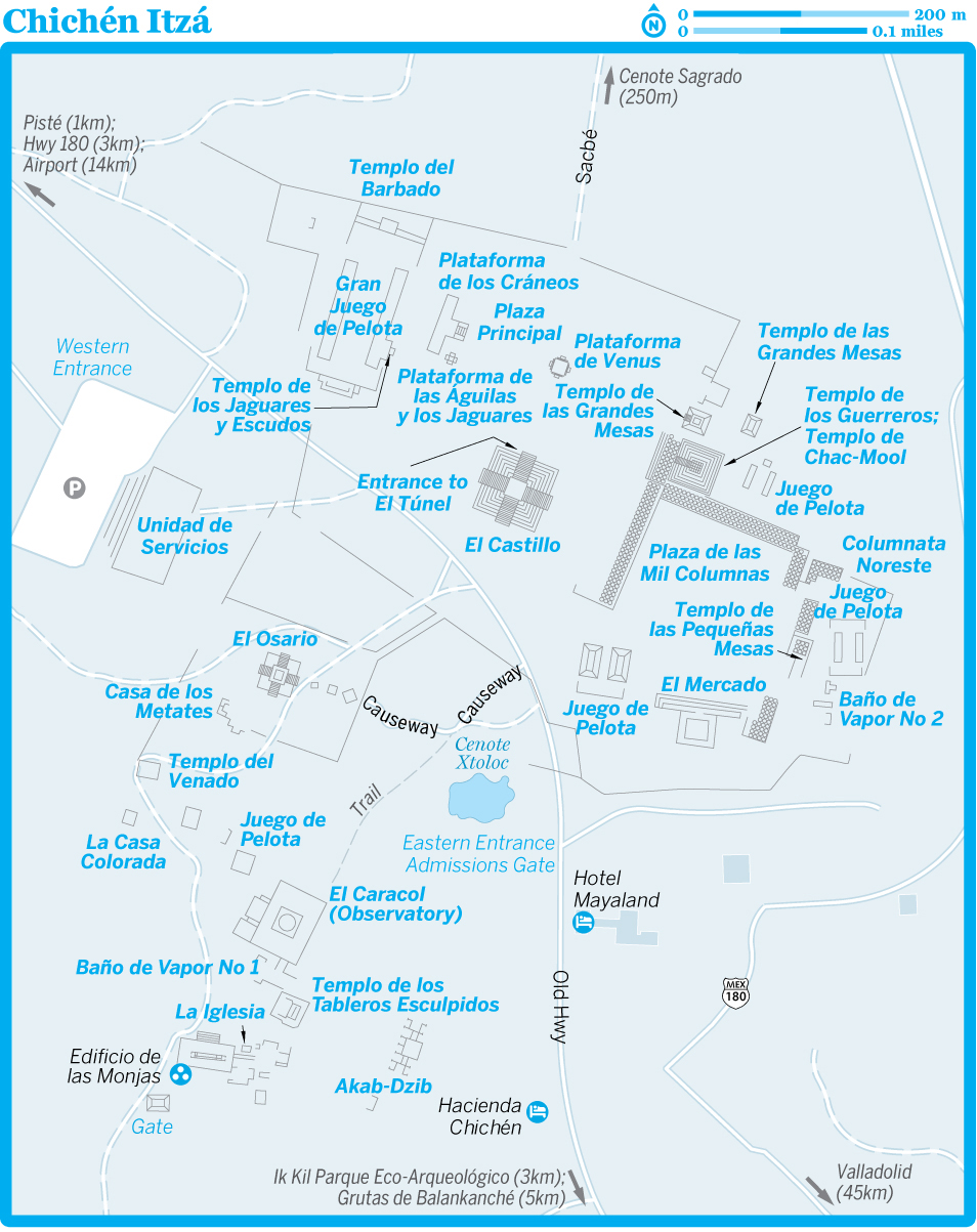
El CastilloARCHAEOLOGICAL SITE
Upon entering Chichén Itzá, El Castillo (aka the Pyramid of Kukulcán) rises before you in all its grandeur. The first temple here was pre-Toltec, built around AD 800, but the present 25m-high structure, built over the old one, has the plumed serpent sculpted along the stairways and Toltec warriors represented in the doorway carvings at the top of the temple. You won’t see the carvings, however, as ascending the pyramid was prohibited after a woman fell to her death in 2006.
The structure is actually a massive Maya calendar formed in stone. Each of El Castillo’s nine levels is divided in two by a staircase, making 18 separate terraces that commemorate the 18 20-day months of the Maya Vague Year. The four stairways have 91 steps each; add the top platform and the total is 365, the number of days in the year. On each facade of the pyramid are 52 flat panels, which are reminders of the 52 years in the Maya calendar round.
To top it off, during the spring and autumn equinoxes, light and shadow form a series of triangles on the side of the north staircase that mimic the creep of a serpent (note the carved serpent’s heads flanking the bottom of the staircase).
The older pyramid inside El Castillo has a red jaguar throne with inlaid eyes and spots of jade; also lying behind the screen is a chac-mool (Maya sacrificial stone sculpture). The entrance to El Túnel, the passage up to the throne, is at the base of El Castillo’s north side. You can’t go in, though.
Researchers in 2015 learned that the pyramid most likely sits atop a 20m-deep cenote, which puts the structure at greater risk of collapsing.
Gran Juego de PelotaARCHAEOLOGICAL SITE
The great ball court, the largest and most impressive in Mexico, is only one of the city’s eight courts, indicative of the importance the games held here. The court, to the left of the visitor center, is flanked by temples at either end and is bounded by towering parallel walls with stone rings cemented up high. Along the walls of the ball court are stone reliefs, including scenes of decapitations of players.
There is evidence that the ball game may have changed over the years. Some carvings show players with padding on their elbows and knees, and it is thought that they played a soccer-like game with a hard rubber ball, with the use of hands forbidden. Other carvings show players wielding bats; it appears that if a player hit the ball through one of the stone hoops, his team was declared the winner. It may be that during the Toltec period, the losing captain, and perhaps his teammates as well, was sacrificed.
The court exhibits some interesting acoustics: a conversation at one end can be heard 135m away at the other, and a clap produces multiple loud echoes.
Templo del BarbadoARCHAEOLOGICAL SITE
The structure at the ball court’s north end, called the Temple of the Bearded Man after a carving inside of it, has finely sculpted pillars and reliefs of flowers, birds and trees.
Plataforma de los CráneosARCHAEOLOGICAL SITE
The Platform of Skulls (Tzompantli in Náhuatl, a Maya dialect) is between the Templo de los Jaguares y Escudos and El Castillo. You can’t mistake it, because the T-shaped platform is festooned with carved skulls and eagles tearing open the chests of men to eat their hearts. In ancient days this platform was used to display the heads of sacrificial victims.
Plataforma de las Águilas y los JaguaresARCHAEOLOGICAL SITE
Adjacent to the Platform of Skulls, the carvings on the Platform of the Eagles and Jaguars depict those animals gruesomely grabbing human hearts in their claws. It is thought that this platform was part of a temple dedicated to the military legions responsible for capturing sacrificial victims.

Cenote SagradoARCHAEOLOGICAL SITE
From the Platform of Skulls, a 400m rough stone sacbé (path) runs north (a five-minute walk) to the huge sunken well that gave this city its name. The Sacred Cenote is an awesome natural well, some 60m in diameter and 35m deep. The walls between the summit and the water’s surface are ensnared in tangled vines and other vegetation. There are ruins of a small steam bath next to the cenote.
Grupo de las Mil ColumnasARCHAEOLOGICAL SITE
This group east of El Castillo pyramid takes its name – which means ‘Group of the Thousand Columns’ – from the forest of pillars stretching south and east. The star attraction here is the Templo de los Guerreros (Temple of the Warriors), adorned with stucco and stone-carved animal deities. At the top of its steps is a classic reclining chac-mool figure, but ascending to it is no longer allowed.
Many of the columns in front of the temple are carved with figures of warriors. Archaeologists working in 1926 discovered a Temple of Chac-Mool lying beneath the Temple of the Warriors.
You can walk through the columns on its south side to reach the Columnata Noreste, notable for the ‘big-nosed god’ masks on its facade. Some have been reassembled on the ground around the statue. Just to the south are the remains of the Baño de Vapor (Steam Bath or Sweat House) with an underground oven and drains for the water. The sweat houses (there are two on site) were regularly used for ritual purification.
El OsarioARCHAEOLOGICAL SITE
The Ossuary, otherwise known as the Bonehouse or the Tumba del Gran Sacerdote (High Priest’s Grave), is a ruined pyramid to the southwest of El Castillo. As with most of the buildings in this southern section, the architecture is more Puuc than Toltec. It’s notable for the beautiful serpent heads at the base of its staircases.
A square shaft at the top of the structure leads into a cave below that was used as a burial chamber; seven tombs with human remains were discovered inside.
El CaracolARCHAEOLOGICAL SITE
Called El Caracol (the Snail) by the Spaniards for its interior spiral staircase, this observatory, to the south of the Ossuary, is one of the most fascinating and important of all Chichén Itzá’s buildings (but, alas, you can’t enter it). Its circular design resembles some central highlands structures, although, surprisingly, not those of Toltec Tula.
In a fusion of architectural styles and religious imagery, there are Maya Chaac rain-god masks over four external doors facing the cardinal points. The windows in the observatory’s dome are aligned with the appearance of certain stars at specific dates. From the dome the priests decreed the times for rituals, celebrations, corn-planting and harvests.
Edificio de las MonjasARCHAEOLOGICAL SITE
Thought by archaeologists to have been a palace for Maya royalty, the so-called Edificio de las Monjas (Nunnery), with its myriad rooms, resembled a European convent to the conquistadors, hence their name for the building. The building’s dimensions are imposing: its base is 60m long, 30m wide and 20m high.
The construction is Maya rather than Toltec, although a Toltec sacrificial stone stands in front. A smaller adjoining building to the east, known as La Iglesia (the Church), is covered almost entirely with carvings.
Akab-DzibARCHAEOLOGICAL SITE
East of the Nunnery, the Puuc-style Akab-Dzib is thought by some archaeologists to be the most ancient structure excavated here. The central chambers date from the 2nd century. The name means ‘Obscure Writing’ in Maya and refers to the south-side annex door, whose lintel depicts a priest with a vase etched with hieroglyphics that have yet to be successfully translated.
4Sleeping & Eating
Most of Chichén Itzá’s lodgings, restaurants and services are arranged along 1km of highway in the town of Pisté to the western (Mérida) side of the ruins. It’s about 1.5km from the ruins’ main (west) entrance to the nearest hotel in Pisté, and 2.5km from the ruins to Pisté’s town plaza. Don’t hesitate to haggle for a bed in low season (May through June and August to early December).
The highway (Calle 15) through Pisté is lined with dozens of eateries, large and small. The cheapest are clustered in a roadside market, known as Los Portales, on the west end of town.
Pirámide InnHOTEL$
(![]() %985-851-01-15; www.piramideinn.com; Calle 15 No 30; campsite M$100, r without/with air-con M$500/600;
%985-851-01-15; www.piramideinn.com; Calle 15 No 30; campsite M$100, r without/with air-con M$500/600; ![]() p
p![]() n
n![]() a
a![]() W
W![]() s
s![]() #)
#)
Campers can pitch a tent, enjoy the inn’s pool and use tepid showers in this dated spot. The spacious rooms have decent bathrooms and two spring-me-to-the-moon double beds.
Located on the main drag in Pisté, this place has the closest budget rooms to Chichén Itzá, though it’s still a hike of about 1.5km. Animals are welcome.
Hotel Chichén ItzáHOTEL$$
(![]() %985-851-00-22, USA 800-235-4079; www.mayaland.com; Calle 15 No 45; r/ste M$1310/1750;
%985-851-00-22, USA 800-235-4079; www.mayaland.com; Calle 15 No 45; r/ste M$1310/1750; ![]() p
p![]() n
n![]() a
a![]() W
W![]() s)
s)
On the west side of Pisté, this hotel has 42 pleasant rooms with tiled floors and old-style brick-tiled ceilings. Rooms in the upper range face the pool and the landscaped grounds, and all have firm beds and minibars. Parents may bring two kids under 12 years old for free. The resort is one of the Mayaland chain, which is prominent in the district.
![]() oHacienda ChichénRESORT$$$
oHacienda ChichénRESORT$$$
(![]() %999-920-84-07, USA 877-631-00-45; www.haciendachichen.com; Zona Hotelera Km 120; d from US$224;
%999-920-84-07, USA 877-631-00-45; www.haciendachichen.com; Zona Hotelera Km 120; d from US$224; ![]() p
p![]() n
n![]() a
a![]() W
W![]() s)
s)
About 300m from the Chichén Itzá entrance, this resort sits on the well-manicured grounds of a 16th-century hacienda with an elegant main house and towering ceiba trees. The archaeologists who excavated Chichén during the 1920s lived here in bungalows, which have been refurbished and augmented with new ones. Monthly activities on offer include Maya cooking classes and bird-watching.
One small downer is that the restaurant’s prices are exorbitant.
Hotel MayalandHOTEL$$$
(![]() %998-887-24-95, USA 877-240-5864; www.mayaland.com; Zona Hotelera Km 120; d/ste from M$2100/3500;
%998-887-24-95, USA 877-240-5864; www.mayaland.com; Zona Hotelera Km 120; d/ste from M$2100/3500; ![]() p
p![]() n
n![]() a
a![]() W
W![]() s)
s)
Every world dignitary has stayed at the resort-style Mayaland, it seems. This smart spot in a lovely garden setting is less than 100m from Chichén Itzá and has a ‘private’ entrance. The rooms, garden bungalows and pools are very (very) nice, but when you’re on site at the observatory, El Caracol, you’ll see the hotel cuts a swath through the jungle.
As well as restaurants and all the services, it also offers cultural programs, including a popular ‘Be Maya’ activity where you cook Maya cuisine plus visit the resort’s own replica ‘observatory,’ while learning about the roles of Maya people. The Mayaland Lodge is the second option nearby, and features smart bungalows in a far more private setting.
Cocina Económica FabiolaMEXICAN$
(Calle 15 s/n; mains M$45-70; ![]() h7am-10pm)
h7am-10pm)
For a good, honest, cheap meal hit this humble little place at the end of the strip of eateries opposite the church. For 25 years it’s been churning out sopa de lima (lime soup) and pollo yucateco (Yucatecan chicken).
Las MestizasMEXICAN$$
(![]() %985-851-0069; Calle 15 s/n; mains M$70-110;
%985-851-0069; Calle 15 s/n; mains M$70-110; ![]() h9am-10pm;
h9am-10pm; ![]() a
a![]() W)
W)
The place to go in town if you’re craving decent Yucatecan fare (photos of each dish help you decide). There’s indoor and outdoor seating – depending on the time of day, an outdoor table may mean you’ll be getting tour-bus fumes (and lines of people) to go along with that poc chuk (pork marinated in orange juice and garlic and grilled).
8Getting There & Away
Oriente has ticket offices near the east and west sides of Pisté, and 2nd-class buses passing through town stop almost anywhere along the way.
Many 1st-class buses arrive and depart from the ruins only. These also head to Mérida and Valladolid, as well as to coastal locations in Quintana Roo: Playa del Carmen, Tulum and Cancún. If you plan to see the ruins and then head directly to another city by 1st-class bus, buy your bus ticket at the visitor center before hitting the ruins, to secure your seat.
Colectivos (shared vans) to Valladolid (M$35, 40 minutes) enter the car park.
BUSES FROM CHICHéN ITZá
| DESTINATION | COST (M$) | DURATION (HR) | FREQUENCY (DAILY) |
|---|---|---|---|
| Cancún | 151-298 | 3-4½ | 9 |
| Cobá | 69 | 2 | 7:30am |
| Mérida | 91-168 | 1¾-2½ | frequent |
| Playa del Carmen | 155-314 | 3½-4 | 3 |
| Tulum | 104-220 | 2½-3 | 3 |
| Valladolid | 31-100 | 1 | frequent |
8Getting Around
Buses to Pisté generally stop at the plaza; you can make the hot walk to and from the ruins in 20 to 30 minutes. First-class buses stop at the ruins; for others, check with the driver. The 2nd-class buses will also leave you near Cenote Ik Kil and the Grutas de Balankanché.
There is a taxi stand near the west end of town; the prices are around M$40 to M$50 to the ruins, M$80 to Cenote Ik Kil and M$150 to Grutas de Balankanché.
Valladolid
![]() %985 / Pop 52,000
%985 / Pop 52,000
Also known as the Sultaness of the East, Yucatán’s third-largest city is known for its quiet streets and sun-splashed pastel walls. It’s worth staying here for a few days or longer, as the provincial town makes a great hub for visits to Río Lagartos, Chichén Itzá, Ek’ Balam and a number of nearby cenotes. The city resides at that magic point where there’s plenty to do, yet it still feels small, manageable and affordable.
History
Valladolid has seen its fair share of turmoil and revolt. The city was first founded in 1543 near the Chouac-Ha lagoon some 50km from the coast, but it was too hot and there were way too many mosquitoes for Francisco de Montejo, nephew of Montejo the Elder, and his merry band of conquerors. So they upped and moved the city to the Maya ceremonial center of Zací (sah-see), where they faced heavy resistance from the local Maya. Eventually the Elder’s son – Montejo the Younger – took the town. The Spanish conquerors, in typical fashion, ripped down the town and laid out a new city following the classic colonial plan.
During much of the colonial era, Valladolid’s physical isolation from Mérida kept it relatively autonomous from royal rule, and the Maya of the area suffered brutal exploitation, which continued after Mexican independence. Barred from entering many areas of the city, the Maya made Valladolid one of their first points of attack following the 1847 outbreak of the Caste War in Tepich. After a two-month siege, the city’s occupiers were finally overcome. Many fled to the safety of Mérida; the rest were slaughtered.
Today Valladolid is a prosperous seat of agricultural commerce, augmented by some light industry and a growing tourist trade.

1Sights
![]() oCasa de los VenadosMUSEUM
oCasa de los VenadosMUSEUM
(map Google map ![]() %985-856-22-89; www.casadelosvenados.com; Calle 40 No 204, btwn Calles 41 & 43; admission by donation;
%985-856-22-89; www.casadelosvenados.com; Calle 40 No 204, btwn Calles 41 & 43; admission by donation; ![]() htours 10am or by appointment)
htours 10am or by appointment)
Featuring over 3000 pieces of museum-quality Mexican folk art, this private collection is interesting in that objects are presented in a house, in the context that they were originally designed for, instead of being roped off in glass cases. The tour (in English or Spanish) brushes on the origins of some of the more important pieces and the story of the award-winning restored colonial mansion that houses them.
Catedral de San ServasioCATHEDRAL
(map Google map San Gervasio)
The original edifice was built from the main pyramid in 1545, then it was demolished and rebuilt in the early 1700s. This is the only church with a north-facing entrance in the Yucatán (all the others are east-facing), a way of castigating recalcitrant locals.
2Activities
![]() oHacienda San Lorenzo OxmanSWIMMING
oHacienda San Lorenzo OxmanSWIMMING
(off Calle 54; cenote M$70, cenote & pool M$100; ![]() h9am-6pm)
h9am-6pm)
Once a henequén plantation and a refuge for War of the Castes insurgents in the mid-19th century, today the hacienda’s main draw is a gorgeous cenote that’s far less crowded than other sinkholes in and around Valladolid, especially if you visit Monday through Thursday. If you buy the entry to both you have a M$60 debit to use at the cafe.
To get there by bike or car, take Calle 41A (Calzada de los Frailes) past the Templo de San Bernardino along Calle 54A, turn right on Avenida de los Frailes, then hang a left on Calle 54 and head about 3km southwest. A taxi to the hacienda costs M$80 to M$100.
Cenote X’Kekén y SamuláSWIMMING
(Cenote Dzitnup & Samulá; 1/2 cenotes M$60/90; ![]() h8:30am-5:20pm)
h8:30am-5:20pm)
One of two cenotes at Dzitnup (also known as X’Kekén Jungle Park), X’Kekén is popular with tour groups. A massive limestone formation with stalactites hangs from its ceiling. The pool is artificially lit and very swimmable. Here you can also take a dip in cenote Samulá, a lovely cavern pool with álamo roots stretching down many meters.
Pedaling a rented bicycle to the cenotes takes about 20 minutes. By bike from Pisté’s center take Calle 41A (Calzada de los Frailes), a street lined with colonial architecture. Go one block past the Templo de San Bernardino (map Google map Convento de Sisal; cnr Calles 49 & 51; Mon-Sat M$30, Sun free; ![]() h9am-7pm) along Calle 54A, then make a right on Calle 49, which becomes Avenida de los Frailes and hits the old highway. Follow the ciclopista (bike path) paralleling the road to Mérida for about 3km, then turn left at the sign for Dzitnup and continue for just under 2km. Shared colectivos also depart for Dzitnup.
h9am-7pm) along Calle 54A, then make a right on Calle 49, which becomes Avenida de los Frailes and hits the old highway. Follow the ciclopista (bike path) paralleling the road to Mérida for about 3km, then turn left at the sign for Dzitnup and continue for just under 2km. Shared colectivos also depart for Dzitnup.
Cenote ZacíSWIMMING
(map Google map ![]() %985-856-0818; Calle 36 s/n, btwn Calles 37 & 39; adult M$30, child 3-11yr M$15;
%985-856-0818; Calle 36 s/n, btwn Calles 37 & 39; adult M$30, child 3-11yr M$15; ![]() hcenote 8:30am-5:30pm, restaurant 9am-6pm)
hcenote 8:30am-5:30pm, restaurant 9am-6pm)
One of few cenotes in a downtown location, Cenote Zací, an open-air swimming hole, is a handy place to cool off. While it’s pleasant enough, don’t expect crystalline waters. You might see catfish or, overhead, a colony of bats. The park also holds small souvenir stands plus a pleasant restaurant under a large palapa (mains M$85 to M$140).
TTours
![]() oYucatán Jay Expeditions & ToursBIRDWATCHING, CULTURAL
oYucatán Jay Expeditions & ToursBIRDWATCHING, CULTURAL
(![]() %cell 985-1118000, cell 985-1034918; www.yucatanjay.com;
%cell 985-1118000, cell 985-1034918; www.yucatanjay.com; ![]() h8am-8pm)
h8am-8pm)
This cooperative, run by five informative and enthusiastic individuals from the Xocén community, 14km south of Valladolid, offers a fabulous array of tours, from bird-watching to tours based on Maya culture and gastronomy. They can take you to cenotes and other locations, providing excellent insights into their culture.
Birders are usually delighted at the spotting successes (plus the guides have access to areas of flora and wildlife where you’d normally not be able to enter). They can arrange breakfasts in the community as well.
4Sleeping & Eating
![]() oHostel La CandelariaHOSTEL$
oHostel La CandelariaHOSTEL$
(map Google map ![]() %985-856-22-67; www.hostelvalladolidyucatan.com; Calle 35 No 201F; dm/r incl breakfast from M$230/500;
%985-856-22-67; www.hostelvalladolidyucatan.com; Calle 35 No 201F; dm/r incl breakfast from M$230/500; ![]() n
n![]() i
i![]() W)
W)
A friendly place right on a quiet little square, this hostel can get a little cramped and hot (but some dorms have air-con). The kitchen, a gorgeous elongated garden complete with hammocks, a gals-only dorm and plenty of hangout space, make it one of the best hostels in town. The hostel also rents out bikes for M$20 per hour.
One of the most organized hostels around, its has folders with lists of activities and ideas to keep you there for days, not to mention bike rental, laundry services, dinner options and more. Lovely owner Tania is a woman ‘in the know’!
Casa San RoqueB&B$$
(map Google map ![]() %985-856-26-42; www.casasanroquevalladolid.com; Calle 41 No 193B; r M$1582;
%985-856-26-42; www.casasanroquevalladolid.com; Calle 41 No 193B; r M$1582; ![]() p
p![]() n
n![]() a
a![]() W
W![]() s)
s)
With just six colonial rooms on offer you’ll get more privacy and personalized attention here than at some of the larger hotels on the main plaza. The full breakfast and a pool with dual fountains in the rear garden are the clinchers.
Hotel Zenti’kBOUTIQUE HOTEL$$$
(![]() %985-104-9171; www.zentikhotel.com; Calle 30 No 192C, btwn 27 & 29; cabañas M$2400;
%985-104-9171; www.zentikhotel.com; Calle 30 No 192C, btwn 27 & 29; cabañas M$2400; ![]() p
p![]() a
a![]() W
W![]() s)
s)
It bills itself as a boutique hotel and indeed the multilingual staff and excellent service back this up. It is, in fact, more like a miniresort, with a series of spacious cabañas (if set ever-so-too slightly together) within intimate surrounds. A gorgeous pool, spa, underground swimming cave and fabulous restaurant make this a clincher.
You’ll need your own transportation to get here as it’s just beyond walkable from the center for some, especially at night. Prices are significantly lower outside high season and that’s when you get real value for money. Several walls are covered in impressive murals by contemporary artists.
Casa Tía MichaBOUTIQUE HOTEL$$$
(map Google map ![]() %985-856-04-99; www.casatiamicha.com; Calle 39 No 197; r incl breakfast M$1700-2100;
%985-856-04-99; www.casatiamicha.com; Calle 39 No 197; r incl breakfast M$1700-2100; ![]() p
p![]() n
n![]() a
a![]() W
W![]() s)
s)
The corridor and rear garden are beautifully lit at night in this family-run boutique hotel just off the plaza. Some of the tastefully adorned colonial-style rooms have king-sized beds, and the upstairs suite comes with a Jacuzzi. If the Tía is booked, on the same block you’ll find sister property Casa Marlene (map Google map r incl breakfast M$1700-2100; ![]() p
p![]() a
a![]() W
W![]() s).
s).
![]() oYerba Buena del SisalMEXICAN$
oYerba Buena del SisalMEXICAN$
(map Google map ![]() %985-856-14-06; www.yerbabuenadelsisal.com.mx; Calle 54A No 217; mains M$80-120;
%985-856-14-06; www.yerbabuenadelsisal.com.mx; Calle 54A No 217; mains M$80-120; ![]() h8am-10pm Tue-Sun;
h8am-10pm Tue-Sun; ![]() W
W![]() v)
v)
Wonderfully healthy and delicious dishes are served in a peaceful garden. Tortilla chips and three delectable salsas come to the table while you look over the menu, which offers many great vegetarian and mostly organic dishes, such as the delightful tacos maculum (with handmade corn tortillas, beans, cheese and aromatic Mexican pepper leaf).
At the time of research, they were about to move three houses away but were hoping to re-create the same atmosphere – we believe they will be able to.
![]() oLa Palapita de los TamalesMEXICAN$
oLa Palapita de los TamalesMEXICAN$
(map Google map Calle 42 s/n, cnr Calle 33; tamales M$40; ![]() h8-10pm Mon-Sat;
h8-10pm Mon-Sat; ![]() v)
v)
You’ve probably never had tamales like these before. The menu changes daily here. At last visit, which may or may not have been a Friday, the tamal of the day had a pork, egg and bean filling and was lightly fried in manteca (lard) to give the exterior a hardened texture. Let’s just say it was quite a snack. Great juices, breakfasts and vegan options too.
![]() oNainoINTERNATIONAL$$
oNainoINTERNATIONAL$$
(![]() %985-104-90-71; www.facebook.com/zentikproject; Calle 30, btwn Calles 27 & 29; mains M$80-150;
%985-104-90-71; www.facebook.com/zentikproject; Calle 30, btwn Calles 27 & 29; mains M$80-150; ![]() h7am-noon & 3-10:30pm;
h7am-noon & 3-10:30pm; ![]() p
p![]() W)
W)
Located on the outskirts of town, on the premises of the resort Zenti’k, this pleasant open-air restaurant is a wonderful place for breakfast, lunch or dinner. It serves good international food; well-to-do locals love coming here at any time of day.
6Drinking & Nightlife
![]() oCoffee Bike StationCAFE
oCoffee Bike StationCAFE
(map ![]() %985-122-24-39; www.facebook.com/coffeebikestation2016; Calle 40 No 203, btwn Calles 41 & 43; snacks from M$40;
%985-122-24-39; www.facebook.com/coffeebikestation2016; Calle 40 No 203, btwn Calles 41 & 43; snacks from M$40; ![]() h8:30am-1:30pm & 6-10pm Mon-Fri)
h8:30am-1:30pm & 6-10pm Mon-Fri)
A welcome addition to Valladolid is this funky little coffee and bike-centric cafe. Yes, it really does boast a proper espresso machine and, yes, the owner (Enrique) really does know how to make great coffee. Beware unconventional opening hours, however. Get in while you can as Enrique also takes bike tours. You can rent bikes from here (M$160 per day).
8Getting There & Away
BUS
Valladolid’s main bus terminal is the convenient ADO bus terminal (www.ado.com.mx; cnr Calles 39 & 46). The main 1st-class services are by ADO, ADO GL and OCC; Oriente and Mayab run 2nd-class buses. Buses to Chichén Itzá/Pisté stop near the ruins during opening hours (but double-check).
BUSES FROM VALLADOLID
| DESTINATION | FARE (M$) | DURATION (HR) | FREQUENCY (DAILY) |
|---|---|---|---|
| Cancún | 117-261 | 2½-3½ | frequent |
| Chichén Itzá/Pisté | 31-28 | ¾ | frequent |
| Chiquilá (for Isla Holbox) | 115-170 | 4 | 1 |
| Cobá | 49 | 1 | frequent |
| Izamal | 66 | 2½ | 12:50pm |
| Mérida | 117-204 | 2-3½ | frequent |
| Playa del Carmen | 132-216 | 2½-3 | frequent |
| Tizimín | 30 | 1 | frequent |
| Tulum | 92-126 | 1½-2 | frequent |
COLECTIVO
Colectivos depart as soon as their seats are filled (or you can elect to pay the full fare). Most operate from 7am or 8am to about 7pm.
Direct services run to Mérida (Calle 39; near the ADO bus terminal; M$180, two hours) and Cancún (Calle 41, cnr Calle 38; M$200, two hours); confirm they’re nonstop. Colectivos for Pisté and Chichén Itzá (Calle 39; M$35, one hour) leave north of the ADO bus terminal. For Ek’ Balam (Calle 44 btwn Calles 35 & 37; M$50) take a ‘Santa Rita’ colectivo from Calle 44 between Calles 35 and 37.
It’s possible to get to many of the cenotes. Colectivos depart from different points around the center; ask the locals. Note that these tend to leave in the mornings only.
8Getting Around
The old highway passes through the town center, though most signs urge motorists toward the toll road north of town. To follow the old highway eastbound, take Calle 41; westbound, take Calle 39.
Bicycles are a great way to see the town and get out to the cenotes. You can rent them at Hostel La Candelaria or MexiGo Tours (map Google map ![]() %985-856-07-77; www.mexigotours.com; Calle 43 No 204C, btwn Calles 40 & 42;
%985-856-07-77; www.mexigotours.com; Calle 43 No 204C, btwn Calles 40 & 42; ![]() h4-7pm) for around M$20 per hour.
h4-7pm) for around M$20 per hour.
Ek’ Balam
The tiny village of Ek’ Balam is worth a visit to see what a traditional Maya village looks like. There’s not a lot here, except a handful of artisan stands along the main plaza, which also serves as the town’s soccer field, and a decent accommodation option.
1Sights
Ek’ BalamARCHAEOLOGICAL SITE
(adult M$205, guide M$600; ![]() h8am-4pm)
h8am-4pm)
The fascinating ruined city of Ek’ Balam reached its peak in the 8th century, before being suddenly abandoned. Vegetation still covers much of the archaeological site, but it’s well organized and has a lovely, lush setting. Interesting features include a ziggurat-like structure near the entrance, as well as a fine arch and a ball court. Most impressive, though, is the gargantuan Acrópolis, whose well-restored base is 160m long and holds a ‘gallery’ – actually a series of separate chambers.
Built atop the base of the Acrópolis is Ek’ Balam’s massive main pyramid, reaching a height of 32m and sporting a gaping jaguar mouth. Below the mouth are stucco skulls, while above and to the right sits an amazingly expressive figure. On the right side stand unusual winged human figures (some call them Maya angels, although a much more likely explanation is that they are shaman or medicine men).
The turnoff for the archaeological site is 17km north of Valladolid, and the ruins are another 6km east from the turnoff.
From the Ek’ Balam entrance you can visit the X’Canché Cenote (![]() %cell 985-1009915; www.ekbalam.com.mx/cenote-xcanche; M$50;
%cell 985-1009915; www.ekbalam.com.mx/cenote-xcanche; M$50; ![]() h8am-5pm), believed to have been a ceremonial site.
h8am-5pm), believed to have been a ceremonial site.
4Sleeping
![]() oGenesis Eco-OasisGUESTHOUSE$$
oGenesis Eco-OasisGUESTHOUSE$$
(![]() %cell 985-1010277; www.genesisretreat.com; Ek’ Balam pueblo; d US$65-79;
%cell 985-1010277; www.genesisretreat.com; Ek’ Balam pueblo; d US$65-79; ![]() W
W![]() s)
s) ![]() S
S
This retreat offers B&B intimacy in a quiet, laid-back ecofriendly setting. Mostly it’s environmentally friendly: gray water is used for landscaping, the rooms’ architecture (pitched, thatched roofs) encourages passive cooling, and there’s a dehydrating toilet or two. There’s a chilling swimming pool and a temascal (pre-Hispanic steam bath) on site – and it offers delicious veggie meals made from scratch.
8Getting There & Away
Colectivos (M$50) to Ek’ Balam depart Valladolid from Calle 44, between Calles 35 and 37.
Río Lagartos
![]() %986 / Pop 3000
%986 / Pop 3000
On the windy northern shore of the peninsula, sleepy Río Lagartos (Alligator River) is a fishing village that also boasts the densest concentration of flamingos in Mexico, supposedly two or three flamingos per Mexican, if one believes the provided math. Lying within the Reserva de la Biosfera Ría Lagartos, this mangrove-lined estuary shelters bird species, including snowy egrets, red egrets, tiger herons and snowy white ibis, as well as the crocodiles that gave the town its name. It’s a beautiful area. At the right time of year you can see numerous species of birds without even getting out of your vehicle.
Most residents aren’t sure of the town’s street names, and signs are few. The road into town is the north–south Calle 10, which ends at the waterfront malecón.
There are no banks or ATMs in town and many places do not accept plastic, so bring plenty of cash.
THE MARAUDING PIRATES OF CAMPECHE
Where there’s wealth, there are pirates – this was truer in the 1500s than it is today. And Campeche, which was a thriving timber, chicle (gum) and logwood (a natural source of dye) port in the mid-16th century, was the wealthiest place around.
Pirates (or ‘privateers,’ as some preferred to be called) terrorized Campeche for two centuries. Time and time again the port was invaded, ships sacked, citizens robbed and buildings burned – typical pirate stuff. The buccaneers’ hall of shame included the infamous John Hawkins, Francis Drake, Henry Morgan and the notorious ‘Peg-Leg’ himself. In their most gruesome assault, in early 1663, the various pirate hordes set aside rivalries to converge as a single flotilla upon the city, massacring Campeche’s citizens.
This tragedy finally spurred the Spanish monarchy to take preventive action, but it was another five years before work on the 3.5m-thick ramparts began. By 1686 a 2.5km hexagon incorporating eight strategically placed bastions surrounded the city. A segment of the ramparts extended out to sea so that ships literally sailed into a fortress to gain access to the city. With Campeche nearly impregnable, pirates turned to other ports and ships at sea. In 1717 the brilliant naval strategist Felipe de Aranda began a campaign against the buccaneers, and eventually made this area of the Gulf safe from piracy. Of course, all that wealth from chicle and timber was created using indigenous slaves, leading one to question: who were the real bad guys, anyway?
For a taste of the pirate life, take a 50-minute cruise on a ‘pirate ship’ that heads out Tuesday through Sunday at noon and 5pm (or noon and 6pm in warmer seasons), conditions permitting. Get information at a kiosk near the tranvía kiosk, in the Plaza Principal. (The ship was under maintenance at time of research so check if it’s afloat.)
TTours
![]() oRío Lagartos AdventuresBOATING
oRío Lagartos AdventuresBOATING
(![]() %cell 986-1008390; www.riolagartosadventures.com; Calle 19 No 134; per boat 2hr from US$110, fly-fishing per boat US$195)
%cell 986-1008390; www.riolagartosadventures.com; Calle 19 No 134; per boat 2hr from US$110, fly-fishing per boat US$195)
This outfit run by local expert Diego Núñez Martinez does various water and land expeditions, including flamingo- and crocodile-watching, snorkeling to Isla Cerritos, fly-fishing and excursions designed for photography. Diego is a licensed, fluent, English-speaking guide with formal training as a naturalist. He’s well up to date on the area’s fauna and flora, which includes some 400 bird species.
He organizes the tours out of Ría Maya Restaurante (www.riolagartosadventures.com; Calle 19 No 134, cnr Calle 14; mains M$150-300, lobster M$250-500; ![]() h9am-9pm) and trains local guides.
h9am-9pm) and trains local guides.
Flamingo ToursBIRDWATCHING
The brilliant orange-red flamingos can turn the horizon fiery when they take wing. Depending on your luck, you’ll see either hundreds or thousands of them. The best months for viewing them are June to August. The four primary haunts, in increasing distance from town, are Punta Garza, Yoluk, Necopal and Nahochín (all flamingo feeding spots are named for nearby mangrove patches).
4Sleeping & Eating
Restaurant y Posada MacumbaGUESTHOUSE$
(![]() %986-862-00-92; www.restaurantmacumba.com;
%986-862-00-92; www.restaurantmacumba.com; ![]() hd M$650-850, apt M$900-1200)
hd M$650-850, apt M$900-1200)
One of the village’s best choices to stay, the waterfront Macumba has six smallish and very comfortable rooms, decked out in funky Caribbean design, courtesy of the ultracreative owner. The panoramic view from the apartment makes it a great deal.
El Perico MarineroHOTEL$$
(![]() %986-862-00-58; www.elpericomarinero.com; Calle 9, near Calle 19; d incl breakfast M$800-900;
%986-862-00-58; www.elpericomarinero.com; Calle 9, near Calle 19; d incl breakfast M$800-900; ![]() p
p![]() a
a![]() W
W![]() s)
s)
Río Lagartos’ smartest hotel offers 14 pleasant rooms, some with estuary vistas and handmade wood furnishings, and all with excellent beds.
Restaurant y Posada MacumbaSEAFOOD$$
(![]() %986-862-00-92; www.restaurantmacumba.com; Calle 16 No 102, cnr Calle 11; mains M$85-135;
%986-862-00-92; www.restaurantmacumba.com; Calle 16 No 102, cnr Calle 11; mains M$85-135; ![]() h8am-7pm;
h8am-7pm; ![]() W)
W)
You may feel like you’ve swum into a mermaid’s cave here, such is the owner’s creative flair. Beyond the shell-focused crafts that line the walls, and the fanciful light shades, it’s a decent eatery with excellent seafood. The menu is massive so the photo board (à la Chinese restaurant) will help get you started.
8Getting There & Away
Several Noreste buses run daily between Río Lagartos and Tizimín (M$45, 1¼ hours), Mérida (M$210, three to four hours) and San Felipe (M$20, 20 minutes). Noreste serves Valladolid and Cancún, but you’ll need to transfer in Tizimín. If you are traveling to Valladolid, be sure to catch the 4pm bus from Río Lagartos; the 5pm doesn’t make the connection in Tizimín.
The bus terminal is on Calle 19, between Calles 8 and 10.
Campeche State
Tucked into the southwestern corner of the Yucatán Peninsula, Campeche state is home to low-key villages, vast stretches of tangled jungle, bird-dotted mangroves and lagoons, and some of the region’s most imposing Maya ruins – many of which you might have all to yourself. On deserted beaches endangered turtles lay their eggs, while offshore playful dolphins frolic in the surf. The walled capital city of Campeche is the region’s cultural epicenter, providing a great jumping-off point for your adventures into this offbeat hinterland.
Campeche is the least visited of the Yucatán’s states, laced through with lonely back roads, friendly people, quiet coastlines and a provincial, lost-land charm. It makes a welcome break from the tourist hordes that descend on the peninsula’s more popular destinations; here you’ll find peace, surprising attractions and very genuine, local experiences.
Campeche
![]() %981 / Pop 250,000
%981 / Pop 250,000
Campeche is a colonial fairyland, its walled city center a tight enclave of restored pastel buildings, narrow cobblestone streets, fortified ramparts and well-preserved mansions. Added to Unesco’s list of World Heritage sites in 1999, the state capital lacks a little of a ‘daily life’ ambience as few people actually live in the historic center. But leave the inner walls and you’ll find a genuine Mexican provincial capital complete with a frenetic market, peaceful malecón (boardwalk) and old fishing docks.
Besides the walls and numerous mansions built by wealthy Spanish families during Campeche’s heyday in the 18th and 19th centuries, seven of the baluartes (bastions or bulwarks) have also survived. Two preserved colonial forts guard the city’s outskirts, one of them housing the Museo de la Arquitectura Maya, an archaeological museum with many world-class pieces.
Campeche is the perfect base for day trips to Edzná, the Chenes sites and neighboring beaches.
History
Once a Maya trading village called Ah Kim Pech (Lord Sun Sheep-Tick), Campeche was first briefly approached by the Spaniards in 1517. Resistance by the Maya prevented the Spaniards from fully conquering the region for nearly a quarter-century. Colonial Campeche was founded in 1531, but later abandoned due to Maya hostility. By 1540, however, the conquistadors had gained sufficient control, under the leadership of Francisco de Montejo (the Younger), to found a permanent settlement. They named the settlement Villa de San Francisco de Campeche.
The settlement soon flourished as the major port of the Yucatán Peninsula, but this made it subject to pirate attacks. After a particularly appalling attack in 1663 left the city in ruins, the king of Spain ordered construction of Campeche’s famous bastions, putting an end to the periodic carnage. Today the economy of the city is largely driven by tourism.

1Sights
![]() oMuseo Arqueológico de Campeche & Fuerte de San MiguelMUSEUM, FORT
oMuseo Arqueológico de Campeche & Fuerte de San MiguelMUSEUM, FORT
(Campeche Archaeological Museum; Av Escénica s/n; M$55; ![]() h8:30am-5pm Tue-Sun;
h8:30am-5pm Tue-Sun; ![]() p)
p)
Campeche’s largest colonial fort, facing the Gulf of Mexico some 4km southwest of the city center, is now home to the most important of Maya museums, the excellent Museo Arqueológico de Campeche, and the city’s one must-see museum. Here you can admire emblematic pieces from the sites of Calakmul and Edzná, and from Isla de Jaina, an island north of town once used as a burial site for Maya aristocracy.
Stunning jade jewelry and exquisite vases, masks and plates are thematically arranged in 10 exhibit halls. The star attractions are the jade burial masks from Calakmul. Also displayed are stelae, seashell necklaces and clay figurines.
Equipped with a dry moat and working drawbridge, the fort itself is a thing of beauty. The roof deck, ringed by 20 cannons, affords wonderful harbor views.
To get here take a bus or combi (minibus; marked ‘Lerma’) from the market. Ask the driver to let you off at the access road (just say ‘Fuerte de San Miguel’), then hike 300m up the hill. Taxis cost around M$40 to M$50.
Plaza PrincipalPLAZA
(map)
Shaded by carob trees and ringed by tiled benches and broad footpaths radiating from a belle epoque kiosk, Campeche’s appealingly modest central square started life in 1531 as a military camp. Over the years it became the focus of the town’s civic, political and religious activities and remains the core of public life. Campechanos come here to chat, smooch, have their shoes shined or cool off with an ice cream after the heat of the day.
MalecónWATERFRONT
A popular path for joggers, cyclists, strolling friends and cooing sweethearts, the malecón, Campeche’s 7km-long waterfront promenade, makes for a breezy sunrise ramble or sunset bike ride.
Mansión CarvajalHISTORIC BUILDING
(map Google map Calle 10, btwn Calles 51 & 53; ![]() h8am-2:45pm Mon-Fri)
h8am-2:45pm Mon-Fri) ![]() F
F
Once the mansion of wealthy landowner Fernando Carvajal, this beautiful building now houses state offices. Visitors are welcome to take a peek inside, however. Black-and-white tiled floors, Doric columns, elaborate archways and a dramatic marble and ironwork staircase are highlights. Note the historical plaque.
Monument to the City GatesMONUMENT
Next to the Plaza Moch-Couoh is a monument of the city’s four gates (land, sea, San Román and Guadalupe); these entrances were in the city walls that surrounded the city. The first two are still standing.
Museo del Archivo General de EstadoMUSEUM
(map Google map ![]() %981-816-09-39; Calle 12 No 159;
%981-816-09-39; Calle 12 No 159; ![]() h8am-3pm Mon-Fri)
h8am-3pm Mon-Fri) ![]() F
F
At this small museum, learn how Campeche came to be. It’s free and air-conditioned, and you get to check out old documents and maps, and watch a video (in Spanish or English) that recounts the history of the state.
Catedral de Nuestra Señora de la Purísima ConcepciónCATHEDRAL
(map Google map Calle 55; ![]() h6:30am-9pm)
h6:30am-9pm) ![]() F
F
Dominating Plaza Principal’s east side is the two-towered cathedral. The limestone structure has stood on this spot for more than three centuries, and it still fills beyond capacity most Sundays. Statues of Sts Peter and Paul occupy niches in the baroque facade; the sober, single-nave interior is lined with colonial-era paintings. And at night, the gauzy lights on the illuminated church and other central landmarks creates a magical atmosphere.
Centro Cultural Casa Número 6CULTURAL CENTER
(map Google map Calle 57 No 6; M$20, audio guide M$15; ![]() h8am-9pm Mon-Fri, 9am-9pm Sat & Sun)
h8am-9pm Mon-Fri, 9am-9pm Sat & Sun)
During the prerevolutionary era, when this mansion was occupied by an upper-class campechano family, Número 6 was a prestigious plaza address. Wandering the premises, you’ll get an idea of how the city’s high society lived back then. The front sitting room is furnished with Cuban-style pieces of the period. Inside are exhibition spaces, a pleasant back patio and a gift shop.
Ex-Templo de San José & Bazar ArtesanalHISTORIC BUILDING
(map Google map former San José Church; cnr Calles 10 & 63; ![]() h10am-8pm)
h10am-8pm)
Faced with blue-and-yellow tiles, the Ex-Templo de San José is a wonder; note the lighthouse, complete with weather vane, atop the right spire. Built in the early 18th century by Jesuits who ran it as an institute of higher learning until they were booted out of Spanish domains in 1767, it now serves as the temporary location for the Bazar Artesanal. This is a one-stop shop for regional crafts, at least while the artisans’ market near the Convention Center is being remodeled.
Museo de la Arquitectura MayaMUSEUM
(map Google map Calle 8; M$40; ![]() h8:30am-5:30pm Tue-Sun)
h8:30am-5:30pm Tue-Sun)
The Baluarte de Nuestra Señora de la Soledad, designed to protect the Puerta del Mar, contains the fascinating Museo de la Arquitectura Maya. It provides an excellent overview of the sites around Campeche state and the key architectural styles associated with them. Five halls display stelae taken from various sites, accompanied by graphic representations of their carved inscriptions with brief commentaries in flawless English.
Baluartes
After a particularly blistering pirate assault in 1663, the remaining inhabitants of Campeche set about erecting protective walls around their city. Built largely by indigenous labor with limestone extracted from nearby caves, the barrier took more than 50 years to complete. Stretching more than 2.5km around the urban core and rising to a height of 8m, the hexagonal wall was linked by eight bulwarks. The seven that remain display a treasure trove of historical paraphernalia and artifacts of varying degrees of interest. You can climb atop the bulwarks and stroll sections of the wall for sweeping views of the port.
Two main entrances connected the walled compound with the outside world. The Puerta del Mar (map Google map Sea Gate; cnr Calles 8 & 59) ![]() F provided access from the sea, opening on to a wharf where small craft delivered goods from ships anchored further out. (The shallow waters were later reclaimed so the gate is now several blocks from the waterfront.) The Puerta de Tierra (map Google map Land Gate; Calle 18;
F provided access from the sea, opening on to a wharf where small craft delivered goods from ships anchored further out. (The shallow waters were later reclaimed so the gate is now several blocks from the waterfront.) The Puerta de Tierra (map Google map Land Gate; Calle 18; ![]() h9am-6pm)
h9am-6pm) ![]() F, on the opposite side, was opened in 1732 as the principal ingress from the suburbs. It is now the venue for a sound-and-light show (adult M$60, child 4-10 yr M$30;
F, on the opposite side, was opened in 1732 as the principal ingress from the suburbs. It is now the venue for a sound-and-light show (adult M$60, child 4-10 yr M$30; ![]() h8pm Thu-Sun).
h8pm Thu-Sun).
Baluarte de San Francisco & Baluarte de San JuanHISTORIC BUILDING
(map Google map Calle 18; M$25; ![]() h8am-9pm Mon-Wed, to 6pm Thu & Fri, 9am-6pm Sat & Sun)
h8am-9pm Mon-Wed, to 6pm Thu & Fri, 9am-6pm Sat & Sun) ![]() F
F
Once the primary defensive bastion for the adjacent Puerta de la Tierra, the Baluarte de San Francisco houses a pirate exhibition in both English and Spanish. You also enter here, to walk along the Baluarte de San Juan, the smallest of the seven bulwarks. Here you can see the bell that was rung to alert the population in times of danger. (Different bells around the city had different sounds and meanings.)
Baluarte de Santa RosaHISTORIC BUILDING
(map Google map cnr Calle 14 & Av Circuito Baluartes Sur; ![]() h8am-8pm)
h8am-8pm) ![]() F
F
The Baluarte de Santa Rosa has a gallery that houses temporary exhibitions.
Baluarte de San PedroHISTORIC BUILDING
(map Google map cnr Avs Circuito Baluartes Este & Circuito Baluartes Norte) ![]() F
F
Directly behind Iglesia de San Juan de Dios, the Baluarte de San Pedro served a post-piracy defensive function when it repelled a punitive raid from Mérida in 1824. Carved in stone above the entry is the symbol of San Pedro: two keys to heaven and the papal tiara. It is currently closed to visitors.
Baluarte de Santiago & Jardín Botánico Xmuch HaltúnGARDENS, HISTORIC BUILDING
(map Google map cnr Calles 8 & 49; M$15; ![]() h8am-9pm Mon-Fri, 9am-9pm Sat & Sun)
h8am-9pm Mon-Fri, 9am-9pm Sat & Sun)
Completed in 1704 – the last of the bulwarks to be built – the Baluarte de Santiago houses the Jardín Botánico Xmuch Haltún, a botanical garden with numerous endemic and some introduced plants. It’s not a huge place, but provides a green and peaceful respite when the sun gets particularly brutal.
TTours
Kankabi’ OkTOUR
(map Google map ![]() %981-811-27-92; Calle 59 No 3;
%981-811-27-92; Calle 59 No 3; ![]() h9am-1pm & 5-9pm Mon-Sat)
h9am-1pm & 5-9pm Mon-Sat)
A very reliable outfit that offers four-hour city tours (minimum two people; M$905), trips to archaeological sites such as Edzná (around M$930), Chenes (around M$1733) and the Ruta Puuc (around M$2272). Further afield they go to Cenote Miguel Colorado (M$1463) and Calakmul (M$2500). Also rents out bikes and does ecotourism and beach trips.
4Sleeping
Hostal ViatgerHOSTEL$
(map ![]() %981-811-4500; Calle 51 No 28, btwn 12 & 14; dm/d/tr incl breakfast M$250/790/830;
%981-811-4500; Calle 51 No 28, btwn 12 & 14; dm/d/tr incl breakfast M$250/790/830; ![]() p
p![]() W)
W)
Of the plethora of hostels that have popped up here in the last few years, we like this one for its location in the historic center (but away from the crowds), plus its friendly ambience. Dorms are slightly squishy, but women can enjoy their own space and there’s the option of private doubles and triples.
Hotel CampecheHOTEL$
(map Google map ![]() %981-816-51-83; hotelcampeche@hotmail.com; Calle 57, btwn Calles 8 & 10; s/d with fan M$285/380, r with air-con M$448;
%981-816-51-83; hotelcampeche@hotmail.com; Calle 57, btwn Calles 8 & 10; s/d with fan M$285/380, r with air-con M$448; ![]() a
a![]() W)
W)
Not much in the way of frills here, but the plaza-side location and big rooms in this classically crumbling building make this about the best budget bet in town. A couple of rooms have little balconies looking out over the plaza.
![]() oHotel LópezHOTEL$$
oHotel LópezHOTEL$$
(map Google map ![]() %981-816-33-44; www.hotellopezcampeche.com.mx; Calle 12 No 189; s/d/ste M$950/1080/1250;
%981-816-33-44; www.hotellopezcampeche.com.mx; Calle 12 No 189; s/d/ste M$950/1080/1250; ![]() a
a![]() W
W![]() s)
s)
This business hotel is by far one of Campeche’s best midrange options. Small but modern, comfortably appointed rooms open on to curvy art deco–styled balconies around oval courtyards and pleasant greenery. Bring your swimsuit for the lovely pool out back. Prices are considerably lower outside high season.
Hotel Misión CampecheHOTEL$$
(map ![]() %981-816-45-88; www.hotelmision.com.mx; Calle 10 No 252; r M$1162;
%981-816-45-88; www.hotelmision.com.mx; Calle 10 No 252; r M$1162; ![]() p
p![]() a
a![]() i
i![]() W)
W)
A large central hotel and part of a Mexican chain, this is a good midrange choice. The highlight is the pretty colonial courtyard with 42 large and clean rooms and arcaded corridors. The downside is that the rooms can vary widely in size and the general ‘feng shui’ (read size of windows, orientation and the like); check some out first.
Hotel SocaireBOUTIQUE HOTEL$$
(map ![]() %981-811-21-30; www.hotelsocaire.com; Calle 56 No 17; r from US$82;
%981-811-21-30; www.hotelsocaire.com; Calle 56 No 17; r from US$82; ![]() W
W![]() s)
s)
A charming converted colonial building (the reception area) leads through to a variety of spacious rooms in the rear. At the time of research, some were showing slight signs of humidity. The lovely pool area adds to a pleasant stay. The website photos slightly (over)do it justice, but it’s in a great central location and it’s excellent value.
Hotel Francis DrakeHOTEL$$
(map Google map ![]() %981-811-56-26; www.hotelfrancisdrake.com; Calle 12 No 207; s/d M$890/990, ste from M$1120, incl breakfast;
%981-811-56-26; www.hotelfrancisdrake.com; Calle 12 No 207; s/d M$890/990, ste from M$1120, incl breakfast; ![]() a
a![]() W)
W)
A somewhat baroque lobby leads to cool, fresh rooms with a sprinkling of tasteful decoration. Bathrooms and balconies are tiny, but the rooms are huge (other hotels would call them suites) with king-sized beds and separate sitting areas.
![]() oHacienda Puerta CampecheBOUTIQUE HOTEL$$$
oHacienda Puerta CampecheBOUTIQUE HOTEL$$$
(map Google map ![]() %981-816-75-08; www.luxurycollection.com; Calle 59 No 71; r from US$210;
%981-816-75-08; www.luxurycollection.com; Calle 59 No 71; r from US$210; ![]() a
a![]() i
i![]() W
W![]() s)
s)
This beautiful boutique hotel has 15 suites with high ceilings and separate lounges. Perfectly manicured gardens and grassy lawns offer peace, while the partly covered pool has nearby hammocks that are fit for a Maya king. It also runs a restored luxury hacienda 26km outside the city, on the way to the Edzná ruins.
Hotel Boutique Casa Don GustavoBOUTIQUE HOTEL$$$
(map Google map ![]() %981-816-80-90; www.casadongustavo.com; Calle 59 No 4; r/ste from M$4250/5000;
%981-816-80-90; www.casadongustavo.com; Calle 59 No 4; r/ste from M$4250/5000; ![]() p
p![]() a
a![]() W
W![]() s)
s)
Just 10 rooms decorated with antique furniture (and huge modern bathrooms), though everything is so perfectly museum-like it’s almost hard to relax. There’s a small pool with hammocks nearby, or try the rooftop Jacuzzi. Colorful tiled hallways line an outdoor courtyard, and there’s a restaurant too. Call or check the website for promotions.
5Eating
You can try some good local dishes in Campeche, especially seafood and the likes of cochinita pibil (roasted suckling pig). One of two high-end places steals the show for quality cuisine, but the rest offer fairly straightforward menus, especially eateries in the historic center. However, traditional atmosphere and old-fashioned service make up for bland offerings. Several restaurants offer musical entertainment.
Cafe LuanCAFE$
(map Calle 14 No 132; ![]() h8am-2pm;
h8am-2pm; ![]() W)
W)
This friendly, well-lit spot serves excellent lighter breakfast and lunch snacks, from eggs (any way you want them) to hot cakes and freshly made sandwiches. Reasonable coffee and excellent smoothies make it a great place to grab a welcome break from the heat.
![]() oMarganzoMEXICAN$$
oMarganzoMEXICAN$$
(map Google map ![]() %981-811-38-98; www.marganzo.com; Calle 8 No 267; mains M$160-250;
%981-811-38-98; www.marganzo.com; Calle 8 No 267; mains M$160-250; ![]() h7am-11pm;
h7am-11pm; ![]() W)
W)
Marganzo is popular with tourists and locals, for good reason – the food is great, the portions large and the complimentary appetizers numerous. An extensive menu offers everything from international fare to regional treats such as cochinita pibil. Wandering musicians provide entertainment. Thursday breakfasts come with a 50% discount for females.
![]() oLa PiguaSEAFOOD$$$
oLa PiguaSEAFOOD$$$
(map Google map ![]() %981-811-33-65; Miguel Alemán 179A; mains M$230-300;
%981-811-33-65; Miguel Alemán 179A; mains M$230-300; ![]() h1-9pm)
h1-9pm)
Some of Campeche’s finest meals are served at this upscale restaurant just outside the walls and behind Hotel Plaza (![]() %981-811-99-00; www.hotelplazacampeche.com; cnr Calle 10 & Av Circuito Baluartes; r/ste M$1667/1851;
%981-811-99-00; www.hotelplazacampeche.com; cnr Calle 10 & Av Circuito Baluartes; r/ste M$1667/1851; ![]() p
p![]() a
a![]() W
W![]() s). Service is attentive and the specialties include seafood dishes – camarones al coco (coconut shrimp), whole fish in cilantro sauce and grilled squid with ground almonds and paprika.
s). Service is attentive and the specialties include seafood dishes – camarones al coco (coconut shrimp), whole fish in cilantro sauce and grilled squid with ground almonds and paprika.
6Drinking & Nightlife
![]() oChocol-HaCAFE
oChocol-HaCAFE
(map Google map ![]() %981-811-78-93; Calle 59 No 30; drinks M$25-55, snacks M$55-80;
%981-811-78-93; Calle 59 No 30; drinks M$25-55, snacks M$55-80; ![]() h8am-1pm & 5-11pm Mon-Sat)
h8am-1pm & 5-11pm Mon-Sat)
When that chocolate craving hits, head on over to this cute little cafe with a patio in front and grassy yard in back. Drinks include bittersweet hot chocolate with green tea or chili, and a chocolate frappé. Sweet treats such as cake, crepes and even tamales (yep, all chocolate!) will give you a sugary high.
![]() oSalón Rincón ColonialBAR
oSalón Rincón ColonialBAR
(map Google map Calle 59 No 60; ![]() h10am-9pm)
h10am-9pm)
With ceiling fans high over an airy hall and a solid wood bar amply stocked with rum, this Cuban-style drinking establishment appropriately served as a location for Original Sin, a 2001 movie with Antonio Banderas and Angelina Jolie that was set in Havana. The botanas (appetizers) are exceptionally fine and go down well with a local beer.
7Shopping
Casa de Artesanías TukulnáARTS & CRAFTS
(map Google map ![]() %981-816-21-88; Calle 10 No 33;
%981-816-21-88; Calle 10 No 33; ![]() h9am-9pm)
h9am-9pm)
A central shop selling a lovely and high-quality range of textiles, clothing, hats, hammocks, wood chairs, sweets and so on – all made in Campeche state.
8Information
Campeche has numerous banks with ATMs.
Call 911 in an emergency.
A Central Post Office (cnr Av 16 de Sepiembre & Calle 53; ![]() h8:30am-4pm Mon-Fri)
h8:30am-4pm Mon-Fri)
A Hospital General De Especialidades (![]() %981-127-39-80; Las Flores)
%981-127-39-80; Las Flores)
A Hospital Dr Manuel Campos (![]() %981-811-17-09; Av Circuito Baluartes Norte, btwn Calles 14 & 16)
%981-811-17-09; Av Circuito Baluartes Norte, btwn Calles 14 & 16)
A HSBC Bank (Calle 10, btwn Calles 53 & 55; ![]() h9am-5pm Mon-Fri, to 2pm Sat) Open Saturday.
h9am-5pm Mon-Fri, to 2pm Sat) Open Saturday.
A Módulo de Información Turística del Município de Campeche (![]() %981-811-39-89; Plaza Central;
%981-811-39-89; Plaza Central; ![]() h8am-9pm Mon-Fri, 9am-9pm Sat & Sun) Basic information on Campeche city.
h8am-9pm Mon-Fri, 9am-9pm Sat & Sun) Basic information on Campeche city.
A Secretaría de Turismo (![]() %981-127-33-00; www.campeche.travel) About the only thing this place has going for it is its website with information on the state.
%981-127-33-00; www.campeche.travel) About the only thing this place has going for it is its website with information on the state.
8Getting There & Away
AIR
Campeche’s small but modern airport is 6km southeast of the center; it has car-rental offices and a tiny snack bar. Aeroméxico (![]() %Mexico City 55-51-33-4000; www.aeromexico.com) provides services.
%Mexico City 55-51-33-4000; www.aeromexico.com) provides services.
BUS
Campeche’s main bus terminal (![]() %981-811-99-10; Av Patricio Trueba 237), usually called the ADO or 1st-class terminal, is about 2.5km south of Plaza Principal via Av Central. Buses provide 1st-class services to destinations around the country, along with 2nd-class services to Sabancuy (M$36, two hours), Hecelchakán (M$45, one hour) and Candelaria (M$199, four hours).
%981-811-99-10; Av Patricio Trueba 237), usually called the ADO or 1st-class terminal, is about 2.5km south of Plaza Principal via Av Central. Buses provide 1st-class services to destinations around the country, along with 2nd-class services to Sabancuy (M$36, two hours), Hecelchakán (M$45, one hour) and Candelaria (M$199, four hours).
The 2nd-class terminal (Terminal Sur; ![]() %981-816-34-45; Av Gobernadores 479), often referred to as the ‘old ADO’ station or Autobuses del Sur, is 600m east of the Mercado Principal. Second-class destinations include Hopelchén (M$68, 1½ hours), Xpujil (M$220, four hours) and Bécal (M$60, 1¾ hours).
%981-816-34-45; Av Gobernadores 479), often referred to as the ‘old ADO’ station or Autobuses del Sur, is 600m east of the Mercado Principal. Second-class destinations include Hopelchén (M$68, 1½ hours), Xpujil (M$220, four hours) and Bécal (M$60, 1¾ hours).
Transportes Crígar (Calle 10 No 329) is a handy spot to buy ADO (1st-class) bus tickets. Or try or other travel agencies around town.
To get to the main bus terminal, catch any ‘Las Flores,’ ‘Solidaridad’ or ‘Casa de Justicia’ microbus by the post office. To the 2nd-class terminal, catch a ‘Terminal Sur’ bus from the same point.
A taxi costs around M$40.
BUSES FROM CAMPECHE
| DESTINATION | FARE (M$) | DURATION (HR) | FREQUENCY (DAILY) |
|---|---|---|---|
| Cancún | 652 | 7 | 7 |
| Chetumal | 305-498 | 6½ | 1 |
| Ciudad del Carmen | 250 | 3 | hourly |
| Mérida | 226 | 2½ | hourly |
| Mérida (via Uxmal) | 157 | 4½ | 5 from 2nd-class terminal |
| Mexico City | 1646 | 18 | 3 |
| Palenque | 440 | 5 | 5 |
| San Cristóbal de las Casas | 630 | 10 | 2 |
| Villahermosa | 283-524 | 6 | frequent |
| Xpujil | 220-362 | 5 | 2pm |
CAR & MOTORCYCLE
If you’re arriving in Campeche from the south, via the cuota (toll road), turn left at the roundabout signed for the universidad and follow that road straight to the coast, then go north.
If you’re heading to either Edzná, the long route to Mérida or the fast toll road going south, take Calle 61 to Av Central and follow signs for the airport and either Edzná or the cuota. For the non-toll route south, just head down the malecón. For the short route to Mérida go north on the malecón.
In addition to some outlets at the airport, several car-rental agencies can be found downtown, including Avis (![]() %981-811-07-85; www.avis.mx; Calle 10, btwn 57 & 59;
%981-811-07-85; www.avis.mx; Calle 10, btwn 57 & 59; ![]() h8am-2pm & 4-6pm). Rates start from M$700 per day depending on the season.
h8am-2pm & 4-6pm). Rates start from M$700 per day depending on the season.
8Getting Around
Taxis from the airport to the center cost M$160 (shared taxis M$70 per person); buy tickets at the taxi booth inside the terminal. Going to the airport, some street taxis (ie those not called from your hotel, which are more expensive) charge M$120 to M$150; penny-pinchers can try taking the hourly bus to Chiná (a village outside Campeche; around M$15) from the market, and getting off at the airport entrance, then walking 500m to the airport doors.
Within Campeche city, taxis charge M$30 to M$60; prices are 10% more after 10pm, and 20% more from midnight to 5am.
Most local buses (around M$7) have a stop at or near the Mercado Principal.
Consider pedaling along the malecón; get bike rentals at Kankabi’ Ok.
Drivers should note that even-numbered streets in the centro histórico take priority, but go slowly until you get the hang of the cross streets.
Northern Campeche
Northern Campeche offers a fascinating blend of experiences. An enticing mix of colonial and Maya elements, blended with centuries-old tradition and lush nature, it’s worth spending time here. Hang out with the locals in a colonial plaza of small towns, wander through the alluring complex of Edzná (one of the region’s finest set of ruins) or marvel over the unique features of architecture at the Chenes sites. Top off your experience by trying and buying one of the Yucatan’s traditional panama hats. Another plus? Most of these places are doable as separate day trips from Campeche.
Chenes Sites
Northeastern Campeche state is dotted with more than 30 sites in the distinct Chenes style, recognizable by the monster motifs around doorways in the center of long, low buildings of three sections, and temples atop pyramidal bases. Most of the year you’ll have these sites to yourself. The three small sites of El Tabasqueño, Hochob and Dzibilnocac make for an interesting day trip from Campeche if you have your own vehicle, or you can take a tour from Campeche with Kankabi’ Ok Tours – at the time of research they went to Hochob, Tohcok and Dzibilnocac.
1Sights
DzibilnocacARCHAEOLOGICAL SITE
(M$40; ![]() h8am-5pm)
h8am-5pm) ![]() F
F
Though it only has one significant structure, Dzibilnocac possesses an eerie grandeur that merits a visit. Unlike the many hilltop sites chosen for Chenes structures, Dzibilnocac (‘big painted turtle’ is one translation) is on a flat plain, like a large open park. As Stephens and Catherwood observed in 1842, the many scattered hillocks in the zone, still unexcavated today, attest to the presence of a large city.
The single, clearly discernible structure is A1, a palatial complex upon a 76m platform with a trio of raised temples atop rounded pyramidal bases. The best preserved of the three, on the east end, has fantastically elaborate monster-mask reliefs on each of its four sides and the typically piled-up Chac masks on three of the four corners.
Dzibilnocac is located beside the village of Iturbide (also called Vicente Guerrero), 20km northeast of Dzibalchén. From Campeche’s 2nd-class bus terminal there are several buses daily to Iturbide via Hopelchén (M$108, three hours). There’s no place to stay here so you’ll need to make it back to Hopelchén by nightfall.
HochobARCHAEOLOGICAL SITE
(M$40; ![]() h8am-5pm)
h8am-5pm)
About 60km south of Hopelchén, Hochob, ‘the place where corn is harvested,’ is among the most beautiful and terrifying of the Chenes-style sites. The Palacio Principal (Estructura 2, though signposted as ‘Estructura 1’) is on the north side of the main plaza, faced with an elaborate doorway representing Itzamná, creator of the ancient Maya, as a rattlesnake with open jaws.
Facing it across the plaza, Estructura 5 has two raised temples on either end of a long series of rooms; the better preserved eastern temple retains part of its perforated roofcomb.
To reach Hochob, go 5km south from El Tabasqueño, then turn right just before the Pemex station at Dzilbalchén. Now go 7.5km to the Chencoh sign, turn left, then after 400m go left again. Drive another 3.5km to Hochob.
El TabasqueñoARCHAEOLOGICAL SITE
(![]() h8am-5pm)
h8am-5pm) ![]() F
F
Supposedly named after a local landowner from Tabasco, El Tabasqueño boasts a temple-palace (Estructura 1) with a striking monster-mouth doorway, flanked by stacks of eight Chac masks with hooked snouts. Estructura 2 is a solid free-standing tower, an oddity in Maya architecture.
To reach El Tabasqueño, go 30km south from Hopelchén. Just beyond the village of Pakchén, there’s an easy-to-miss sign at a turnoff on the right; follow this rock-and-gravel road 2km to the site.
8Getting There & Away
If you don’t have your own wheels, head off on a day trip from Campeche with Kankabi’ Ok Tours. There is no easy public transportation to these, or other Chenes, sites.
Edzná
If you only have the time or inclination to visit one archaeological site in northern Campeche, Edzná should be your top pick. It’s located about 60km southeast of Campeche.
1Sights
![]() oEdznáARCHAEOLOGICAL SITE
oEdznáARCHAEOLOGICAL SITE
(M$55; ![]() h8am-5pm)
h8am-5pm)
Edzná’s massive complexes, that once covered more than 17 sq km, were built by a highly stratified society that flourished from about 600 BC to the 15th century AD. During that period the people of Edzná built more than 20 complexes in a melange of architectural styles, installing an ingenious network of water-collection and irrigation systems. (Though it’s a long way from such Puuc Hills sites as Uxmal and Kabah, some of the architecture here has elements of the Puuc style.)
Most of the visible carvings date from AD 550 to 810.
The causes leading to Edzná’s decline and gradual abandonment remain a mystery; the site remained unknown until its rediscovery by campesinos in 1906.
Edzná means ‘House of the Itzáes,’ a reference to a predominant governing clan of Chontal Maya origin. Edzná’s rulers recorded significant events on stone stelae. Around 30 stelae have been discovered adorning the site’s principal temples; a handful are on display underneath a palapa just beyond the ticket office.
A path from the palapa leads about 400m through vegetation; follow the ‘Gran Acropolis’ sign. Soon, to your left, you’ll come upon the Plataforma de los Cuchillos (Platform of the Knives), a residential complex highlighted by Puuc architectural features. The name is derived from an offering of silica knives that was found within.
Crossing a sacbé (stone-lined, grass walkway), you arrive at the main attraction, the Plaza Principal. Measuring 160m long and 100m wide, the Plaza Principal is surrounded by temples. On your right is the Nohochná (Big House), a massive, elongated structure topped by four long halls likely used for administrative tasks, such as the collection of tributes and the dispensation of justice.
Across the plaza is the Gran Acrópolis, a raised platform holding several structures, including Edzná’s major temple, the 31m-high Edificio de los Cinco Pisos (Five-Story Building). The current structure is the last of four remodels and was done primarily in the Puuc style. It rises five levels from its base to the roofcomb and contains many vaulted rooms. Note the well-preserved glyphs along the base of the central staircase.
South of Plaza Principal is the Templo de los Mascarones (Temple of the Masks), with a pair of reddish stucco masks underneath a protective palapa. Personifying the gods of the rising and setting sun, these extraordinarily well-preserved faces display dental mutilation, crossed eyes and huge earrings, features associated with the Maya aristocracy.
8Getting There & Away
Combis (around M$50, one hour) leave when full from Calle Chihuahua near Campeche’s Mercado Principal. Most drop you 200m from the site entrance unless the driver is feeling generous. The last combi back is midafternoon (some say 2pm, others 3pm…you get the idea), so ask the driver to make sure!
Kankabi’ Ok in Campeche provides guided tours of Edzná (including transportation) for around M$930 per person.
Southeastern Campeche
The southern peninsular region from Escárcega to Xpujil, which borders modern-day Guatemala, was the earliest established, longest inhabited and most densely populated region in the Maya world. Here you’ll find the most elaborate Maya archaeological sites on the Yucatán Peninsula.
Among the region’s archaeological sites, the Río Bec architectural style dominates. It is actually a hybrid of styles fusing elements from the Chenes region to the north and Petén to the south. Río Bec structures are characterized by long, low buildings divided into three sections, with a huge ‘monster’ mouth glaring from a central doorway. The facades are decorated with smaller masks and geometric designs. At each end are tall, smoothly rounded towers with banded tiers supporting small false temples flanked by extremely steep, nonfunctional steps.
The most significant is the spectacular Calakmul set amid the ecologically diverse, and very lush, Reserva de la Biosfera Calakmul.
Calakmul
The most remote of all the Maya ruins, Calakmul is also one worth making the effort to get to. Simply put, it’s a magnificent experience, made even better by its history as a leading city from around AD 250. Many buildings survive, giving an evocative sense of a powerful place.
But visiting Calakmul is not just a historical experience, it’s also an ecological one. Lying at the heart of the vast, untrammeled Reserva de la Biosfera Calakmul (which covers close to 15% of the state’s total territory), the ruins are surrounded by rain forest and seemingly endless canopy of vegetation. You might glimpse ocellated turkeys, parrots, toucans and more – around 350 bird species reside or fly through here. You’ll no doubt see or hear spider and howler monkeys, too, but you’re much less likely to spot a jaguar – one of five kinds of wildcat in the area.
1Sights
![]() oCalakmulARCHAEOLOGICAL SITE
oCalakmulARCHAEOLOGICAL SITE
(M$184; ![]() h8am-5pm)
h8am-5pm)
Possibly the largest city during Maya times, Calakmul was ‘discovered’ in 1931 by American botanist Cyrus Lundell. The site bears comparison in size and historical significance to Tikal in Guatemala, its chief rival for hegemony over the southern lowlands during the Classic Maya era. It boasts the largest and tallest known pyramid in Yucatán, and was once home to over 50,000 people.
A central chunk of the 72-sq-km expanse has been restored, but most of the city’s approximately 6000 structures lie covered in jungle. In 2004, amazingly well-preserved painted murals were discovered at the Chiik Naab acropolis of Estructura 1. They depicted something never before seen in Maya murals – the typical daily activities of ordinary Maya (as opposed to the usual political, ceremonial or religious themes). A few years before that, a significant 20m-long, 4m-high stucco frieze was uncovered at Estructura II, whose features seemed to mark a transition between Olmec and Maya architecture.
Unfortunately, the murals and frieze are not open to the public, but their reproductions can be seen at Calakmul’s modern Museo de Naturaleza y Arqueología (![]() h7am-3pm)
h7am-3pm) ![]() F, at Km 20 on the 60km side road to Calakmul. This worthwhile museum also has geological, archaeological and natural-history exhibits.
F, at Km 20 on the 60km side road to Calakmul. This worthwhile museum also has geological, archaeological and natural-history exhibits.
At the time of research, you pay three different fees: the community entrance (M$50), biosphere entrance (M$64) and the site entrance M$70. This combination seems subject to change.
TTours
From Campeche, Kankabi’ Ok runs tours to Calakmul. Alternatively, from Xpujil, Ka’an Expeditions (![]() %983-871-60-00; www.kaanexpeditions.com; Av Calakmul s/n; per person US$75;
%983-871-60-00; www.kaanexpeditions.com; Av Calakmul s/n; per person US$75; ![]() hnoon-8pm Tue-Sun) also runs a fairly ‘cookie-cutter’ but convenient tour, or a good English-speaking outfit is Calakmul Adventures (
hnoon-8pm Tue-Sun) also runs a fairly ‘cookie-cutter’ but convenient tour, or a good English-speaking outfit is Calakmul Adventures (![]() %cell 983-1841313; www.calakmuladventures.com; around M$1300). Just west of Xpujil, Río Bec Dreams (www.riobecdreams.com; Hwy 186 Km 142, Becán; 2-person cabaña M$1050-1350, 3-person cabaña M$1400-1550, 4-person cabaña M$1750;
%cell 983-1841313; www.calakmuladventures.com; around M$1300). Just west of Xpujil, Río Bec Dreams (www.riobecdreams.com; Hwy 186 Km 142, Becán; 2-person cabaña M$1050-1350, 3-person cabaña M$1400-1550, 4-person cabaña M$1750; ![]() p
p![]() n) arranges tours with English-speaking guides, but these are only available to its guests.
n) arranges tours with English-speaking guides, but these are only available to its guests.
If you want to arrange something on the hop, certified guides wait at the turnoff from Hwy 186 (at the entrance to the 20km of lands owned by the local community of Conhuas). They charge around M$600 for a multihour visit, but you need your own transportation. Most speak Spanish only.
If you want a real DIY experience, you can hire a taxi from Escárgeca or Xpujil (around M$1400 with a three-hour wait).
4Sleeping
Campamento Yaax’ CheCAMPGROUND$
(Servidores Turísticos Calakmul; ![]() %cell 983-1348818; www.ecoturismocalakmul.com; own/fixed tent US$6/19)
%cell 983-1348818; www.ecoturismocalakmul.com; own/fixed tent US$6/19)
The closest campground to the Calakmul site, and the nearest thing to a camping experience in the jungle, this is located several kilometers after the turnoff from Hwy 186 on the road to Calakmul and another 700m in on a rough road. It’s a relaxed, wilderness-style campground with sites for BYO tents. Or you can opt for ready-pitched tents.
It can be muddy when wet. There are environmentally friendly dry toilets and ‘natural’ showers plus a communal palapa. Meals can be arranged. Head honchos Fernando and Leticia offer tours, too (from around M$900 per person for the three-hour jungle tour; from M$1200 to archaeological sites; minimum numbers apply).
8Getting There & Away
Calakmul is 60km south of Hwy 186 at the end of a good paved road (the turnoff is 56km west of Xpujil).
Chicanná & Becán
Chicanna & Becan are two interesting sites that are easily accessible from Hwy 186, located 10km and 8km respectively west of Xpujil. They represent fascinating examples of Chenes and Río Bec styles.
1Sights
ChicannáARCHAEOLOGICAL SITE
(M$50; ![]() h8am-5pm)
h8am-5pm)
Aptly named ‘House of the Snake’s Jaws,’ this Maya site is best known for one remarkably well-preserved doorway with a hideous fanged visage. Located 11km west of Xpujil and 400m south of Hwy 186, Chicanná is a mixture of Chenes and Río Bec architectural styles buried in the jungle. The city attained its peak during the late Classic period, from AD 550 to 700, as a sort of elite suburb of Becán.
Beyond the admission pavilion, follow the rock paths through the jungle to Estructura XX, which boasts two monster-mouth doorways, one above the other. The top structure is impressively flanked by rounded stacks of crook-nosed Chac masks.
A five-minute walk along the jungle path brings you to Estructura XI, with what remains of some of the earliest buildings. Continue along the main path about 120m northeast to reach the main plaza. Standing on the east side is Chicanná’s famous Estructura II, with its gigantic Chenes-style monster-mouth doorway, believed to depict the jaws of the god Itzamná – lord of the heavens and creator of all things. Note the painted glyphs to the right of the mask. A path leading from the right corner of Estructura II takes you to Estructura VI, which has a well-preserved roofcomb and some beautiful profile masks on its facade. Circle around the back, noting the faded red-painted blocks of the west wing, then turn right to hike back to the main entrance.
BecánARCHAEOLOGICAL SITE
(M$55; ![]() h8am-5pm) The Maya word for ‘canyon’ or ‘moat’ is becán, and indeed a 2km moat snakes its way around this must-visit Maya site. Seven causeways provide access across the moat to the 12-hectare site, within which are the remains of three separate architectural complexes. A strategic crossroads between the Petenes civilization to the south and Chenes to the north, Becán displays architectural elements of both, with the resulting composite known as the Río Bec style.
h8am-5pm) The Maya word for ‘canyon’ or ‘moat’ is becán, and indeed a 2km moat snakes its way around this must-visit Maya site. Seven causeways provide access across the moat to the 12-hectare site, within which are the remains of three separate architectural complexes. A strategic crossroads between the Petenes civilization to the south and Chenes to the north, Becán displays architectural elements of both, with the resulting composite known as the Río Bec style.
The elaborate defenses surrounding the site allude to the militaristic nature of the city, which, from around AD 600 to 1000, was a regional capital encompassing Xpujil and Chicanná.
Enter the complex via the western causeway, skirting Plaza del Este on your left. Proceed through a 66m-long arched passageway and you will emerge on to the Plaza Central, ringed by three monumental structures. The formidable 32m Estructura IX, on the plaza’s north side, is Becán’s tallest building – though the sign says not to climb it, a rope is provided! Estructura VIII is the huge temple on your right, with a pair of towers flanking a colonnaded facade at the top. It’s a great vantage point for the area; with binoculars, you can make out Xpujil’s ruins to the east. Across the plaza from VIII is Estructura X, with fragments of an Earth Monster mask still visible around the central doorway. The other side of X opens on to the west plaza, with a ritual ball court. As you loop around Estructura X to the south, check out the encased stucco mask on display.
Follow around the right side of the mask to another massive edifice, Estructura I, which takes up one side of the eastern plaza. Its splendid south wall is flanked by a pair of amazing Río Bec towers rising 15m. Ascend the structure on the right side and follow the terrace alongside a series of vaulted rooms back to the other end, where a passage leads you into the Plaza del Este. The most significant structure here is Estructura IV, on the opposite side of the plaza; experts surmise it was a residence for Becán’s aristocrats. A stairway leads to an upstairs courtyard ringed by seven rooms with cross motifs on either side of the doorways. Finally, go around Estructura IV to complete the circle. Becán is located 8km west of Xpujil, 500m north of the highway.
8Getting There & Away
Your own transportation is required to get to these sites. Alternatively, a taxi from Xpujil costs around M$500 with one-hour wait at each.
Xpujil
![]() %983 / Pop 4000
%983 / Pop 4000
Although unremarkable, the small town of Xpujil (shpu-heel) has expanded over the last few years, especially given its proximity to the area’s many ruins. As such, it’s a useful base. It has a few hotels, some unexceptional eateries, several ATMs (one at supermarket Willy’s), an exchange house (Elektra Dinero on Calle Chicanna near Xnantun) and a bus terminal. Most services are along the seven-block main drag, Av Calakmul (aka Hwy 186) and one street heading inland. There are three gas stations in the area.
1Sights
XpuhilARCHAEOLOGICAL SITE
(M$50; ![]() h8am-5pm)
h8am-5pm)
The ruins of Xpuhil are a striking example of the Río Bec style. The three towers (rather than the usual two) of Estructura I rise above a dozen vaulted rooms. The 53m central tower is the best preserved. With its banded tiers and impractically steep stairways leading up to a temple that displays traces of a zoomorphic mask, it gives you a good idea of what the other two towers must have looked like in Xpuhil’s 8th-century heyday. Go around back to see a fierce jaguar mask embedded in the wall below the temple.
The ruins are located on the western edge of Xpujil town; it’s about a 1km walk from the entrance to the ruins, which are in a pretty setting.
OFF THE BEATEN TRACK
HORMIGUERO
The buildings of Hormiguero (![]() h8am-5pm) date as far back as AD 50; the city (whose name is Spanish for ‘anthill’) flourished during the late Classic period. Until recent times, the site was not easy to reach; the road, although overgrown, is largely sealed. Hormiguero has two impressive and unique buildings in a stunning, lush setting that are worth the trek. You are likely to have the site to yourself.
h8am-5pm) date as far back as AD 50; the city (whose name is Spanish for ‘anthill’) flourished during the late Classic period. Until recent times, the site was not easy to reach; the road, although overgrown, is largely sealed. Hormiguero has two impressive and unique buildings in a stunning, lush setting that are worth the trek. You are likely to have the site to yourself.
As you enter you’ll see the 50m-long Estructura II. The facade’s chief feature is a very menacing Chenes-style monster-mouth doorway, jaws open wide, set back between a pair of Classic Río Bec tiered towers. Around the back is intact Maya stonework and the remains of several columns. Follow the arrows 60m north to reach Estructura V, with a much smaller but equally ornate open-jawed temple atop a pyramidal base. Climb the right side for a closer look at the incredibly detailed stonework, especially along the corner columns that flank the doorway.
This site is reached by heading 14km south from Xpujil’s stoplight, then turning right and going 8km west on a sealed road (the final 2km are on a rough, dirt road).
4Sleeping & Eating
Xpujil’s sleeping options are all along the main highway, which can be noisy. Around the bus terminal at the east end of town you’ll find cheap hotels; the nicer hotels are at the west end of town. Some of the best options are near Bécan, around 12km west of Xpujil.
Aside from the hotel restaurants, various greasy spoons are clustered around the bus station and roadside taquerías (taco stands) toward the Xpuhil ruins. There’s a small supermarket next to the bus station. There is an excellent restaurant (https://riobecdreams.com; Hwy 186 Km 142; mains M$120-220; ![]() h7:30am-9pm;
h7:30am-9pm; ![]() p) near Bécan, around 12km west of Xpujil.
p) near Bécan, around 12km west of Xpujil.
Hotel Maya BalamHOTEL$$
(Calle Xpujil s/n, btwn Av Calakmul & Silvituc; d M$490-690, tr M$590; ![]() p
p![]() a
a![]() W)
W)
The best of a fairly basic lot in town, this place is small and modern with clean rooms. There’s not much outlook (back rooms face on to the car park), but it’s fine for a night or two if you’re exploring the area.
Sazon VeracruzanoMEXICAN$$
(Av Calakmul 92; mains M$130-170; ![]() h7am-11pm Mon-Sat)
h7am-11pm Mon-Sat)
Even though it’s a casual place with bright orange exterior and even more vibrant plastic tablecloths, it’s as smart as you’ll get in Xpujul. It offers a big menu of Mexican dishes (with a focus on Veracruz, where the owners are from). Think the likes of fajita la arrachera (beef strips; M$170) and fried fish fillet.
8Getting There & Away
The bus terminal (![]() %983-871-65-11) is just east of the Xpujil stoplight next to the Victoria Hotel. Services head to/from Campeche (M$260 to M$370, one daily, 4½ hours; via Champotón), plus Chetumal.
%983-871-65-11) is just east of the Xpujil stoplight next to the Victoria Hotel. Services head to/from Campeche (M$260 to M$370, one daily, 4½ hours; via Champotón), plus Chetumal.
There are also taxi colectivos to Chetumal (M$120 per person, 1½ hours). You’ll find these near the traffic circle opposite the bus terminal.