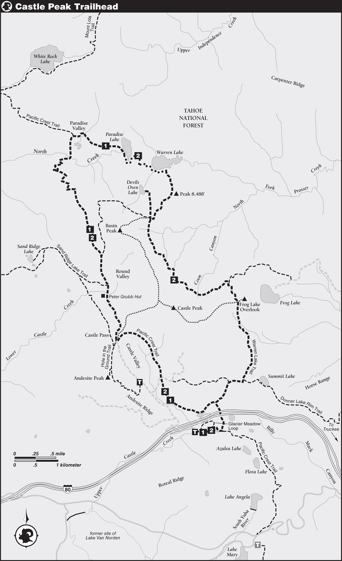
INFORMATION AND PERMITS: The Castle Peak area is in Tahoe National Forest: 631 Coyote St., Nevada City, CA 95959; 530-265-4531, fs.usda.gov/tahoe. For now, you don’t need a wilderness permit, but you do need a California Campfire Permit for campfires and stoves.
DRIVING DIRECTIONS: West of Donner Summit, take the Castle Peak/Boreal Ridge Road Exit 176 from I-80, drive to the frontage road on the south side of the freeway, and then proceed east 0.3 mile to the PCT parking area. The large parking lot has trailer parking, pit toilets, and running water in season.
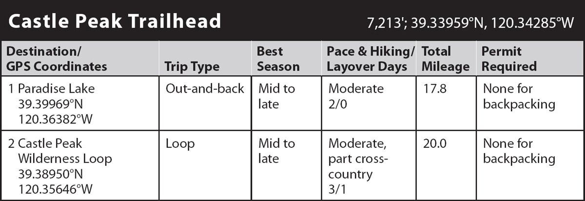
trip 1 Paradise Lake
Trip Data: |
39.39969°N, 120.36382°W; 17.8 miles; 2/0 days |
Topos: |
Norden, Independence Lake |
HIGHLIGHTS: The PCT combined with a 1-mile stretch of abandoned jeep road provides a well-graded route to island-dotted Paradise Lake, one of the most picturesque subalpine lakes in the greater Tahoe area. For those who aren’t up to the more difficult trek of the full loop past Warren Lake, with a side trip to Devils Oven Lake on the way (Trip 2), an out-and-back trip to Paradise Lake is a great way to spend a couple of days or more.
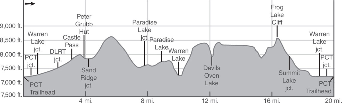
DAY 1 (Castle Peak Trailhead to Paradise Lake, 7.7 miles): From the parking lot, follow a well-signed gravel path to a stone bridge over a seasonal stream and continue on dirt track through lodgepole pines, western white pines, and white firs. Soon you encounter a junction with the Glacier Meadow Loop and proceed ahead (east) toward the PCT. After a short distance you pass by a second junction with the Glacier Meadow Loop and continue ahead (east) toward the PCT. Head past a shallow pond, where mountain hemlocks join the mixed forest, and then make a short descent to the well-signed PCT junction near the edge of a grass-and-willow-filled meadow.
Turn left and head north on the PCT around the fringe of the meadow to a pair of large pedestrian culverts underneath the eastbound and westbound lanes of I-80. Pass under the freeway and beyond the culverts, make a moderate climb to the crossing of a seasonal creek, and then come to a well-signed junction, 1 mile from the trailhead.
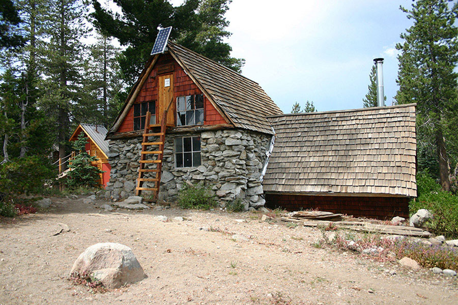
Peter Grubb Hut Photo by Mike White
At the junction, turn left (southwest) on the PCT, following signed directions to Castle Pass. The PCT rises and then drops to the north shore of a small pond and an unsigned path to the westbound Donner Summit Rest Area. Stay on the PCT here.
Beyond the unmarked junction, follow the gently graded PCT through mixed forest toward Castle Valley. The trail nears Castle Creek for a brief time and then travels just east of the verdant meadows of Castle Valley, where two use trails branch away toward the creek and meadows. At 2.3 miles from the trailhead, reach a junction with the Donner Lake Rim Trail on the right, and then continue generally north upstream through Castle Valley, hopping over a number of lushly lined tributaries along the way. Nearing the head of the valley, the PCT bends west, then south-southwest on an ascending traverse to a signed junction with a connecting trail from the Castle Valley Road. From there, make a short but stiff climb to Castle Pass and a junction with a trio of paths: northeast to the summit of Castle Peak, southeast to a connection with the trail to Andesite Peak, and north on the PCT toward Round Valley.
Take the middle fork north from Castle Pass, remaining on the PCT, on a traverse across a lightly forested slope. After about a half mile, begin a moderate, switchbacking descent toward Round Valley below. Nearing the floor of the valley, pass a very short use trail on the left that leads to Peter Grubb Hut.
PETER GRUBB HUT
Following a ski trip to the Swiss Alps, Harold T. Bradley, university professor and former president of the Sierra Club, proposed a string of six alpine huts between Donner and Echo Passes, similar to the ones he’d experienced in the Alps. Although only four of the six were eventually completed, the huts have provided warm shelter for many visitors since the late 1930s. Peter Grubb Hut is complete with a wood-burning stove and firewood, a gas stove and cooking utensils, a table and chairs, a loft with sleeping platforms, solar lights, and a detached out-house. Interesting old photos and memorabilia cover the walls and provide a sample of the area’s history. Except for emergency shelter, overnight use of Peter Grubb Hut is by reservation only. Contact the Sierra Club at Clair Tappaan Lodge, PO Box 36, Norden, CA 95724; 530-426-3632, sierraclub.org/outings/lodges/ctl.
The PCT crosses Lower Castle Creek just north of the hut and then soon comes to a Y-junction with the Sand Ridge Trail, where you continue ahead, northbound.
Skirt the western fringe of Round Valley through light forest and then follow a moderate climb with occasional filtered views of the terrain to the west. Break out of the trees to sweeping views farther up the southwest shoulder of Basin Peak and ascend open slopes carpeted with willows and wildflowers.
BASIN PEAK
Peak baggers can leave the trail anywhere near the high point and make a straightforward climb of flower-covered, volcanic slopes to the top of 9,017-foot Basin Peak, which affords a wide-ranging vista of the northern Tahoe Sierra. A use trail along the crest of the ridge connecting the summits of Basin and Castle Peaks offers climbers with some extra time the opportunity to double summit.
After cresting the shoulder of Basin Peak, the PCT follows a mellow descending traverse across flower-laden slopes before returning to light forest, where an extended, switchbacking descent heads toward the floor of Paradise Valley. At the bottom of the descent, stroll amid pines and firs with a lush understory of plants and flowers to a bridged crossing of lazy North Creek meandering through the tall grass. A gentle, winding climb from the bridge leads past a pond surrounded by the meadows of Paradise Valley to a signed junction with the track of an old jeep road traveling east toward Paradise Lake, 7.8 miles from the parking lot. Early-season visitors to Paradise Valley will be alternately rewarded with a fine display of wildflowers and cursed with hordes of pesky mosquitoes.
Leaving the PCT, turn right (east) at the junction and follow the easy grade of the jeep road around the northern perimeter of Paradise Valley, a verdant clearing carpeted with a dense swath of plants and flowers. Leaving the clearing behind, the jeep road makes a moderate climb through scattered conifers and granite boulders. Eventually, the track of the old road falters, but a ducked route continues the climb toward the obvious location of the lake at the head of the cirque.
Several campsites are clustered around the west side of the picturesque lake (7,729'; 39.39969°N, 120.36382°W) in sandy pockets between the numerous granite slabs scattered around the shoreline. More secluded camping is available along the southwest shore and the saddle above the east shore, where the view down to Warren Lake is quite impressive.
DAY 2 (Paradise Lake to Castle Peak Trailhead, 7.7 miles): Retrace your steps to return.
trip 2 Castle Peak Wilderness Loop

Trip Data: |
39.38950°N, 120.35646°W; 20.0 miles; 3/1 days |
Topos: |
Norden, Independence Lake |
HIGHLIGHTS: While the elevation gain and loss experienced along this route requires hikers to be in very good physical condition, the rewards of incomparable views, picturesque lakes, vibrant wildflowers, and exquisite scenery more than make up for the extra effort. Additional cross-country routes to the summits of Basin or Castle Peaks and plenty of connecting trails provide tantalizing ways to extend your visit to these lands.
HEADS UP! Because of the potentially dangerous cross-country route between Paradise and Warren Lakes and the indistinct trail to Devils Oven Lake, this trip is appropriate for experienced hikers only.
DAY 1 (Castle Peak Trailhead to Paradise Lake, 8.9 miles): From the Castle Peak Trailhead, take the gravel path over the stone bridge, and then follow the dirt track eastward, going ahead (east) at both junctions with the Glacier Meadow Loop. Where you meet the Pacific Crest Trail (PCT), turn left (north) and pass under I-80 to a seasonal stream and a signed junction where you turn left (southwest) to stay on the PCT, heading for Castle Pass. The trail presently curves northwest to an unsigned junction where you go ahead (north) to stay on the PCT along Castle Valley, passing by use trails into the valley. Pass by a junction with the Donner Lake Rim Trail and continue on the PCT as it bends west and then southwest to a junction with a trail to Castle Valley Road. Stay on the PCT here, climbing southwest to Castle Pass and a junction with three trails. Take the middle fork, the PCT, north toward Round Valley, passing the use trail to the Peter Grubb Hut. Skirt Round Valley, ascend the shoulder of Basin Peak, and descend into Paradise Valley. At the junction with the old road to Paradise Lake, turn right (east) to leave the PCT and follow first the road and then ducks to the lake (7,729'; 39.39969°N, 120.36382°W).
DAY 2 (Paradise Lake to Devils Oven Lake, 2.2 miles, part cross-country): A short climb up and over some bedrock cliffs at the south end of Paradise Lake is necessary in order to reach the saddle and the continuation of the loop trip via the cross-country route down to Warren Lake.
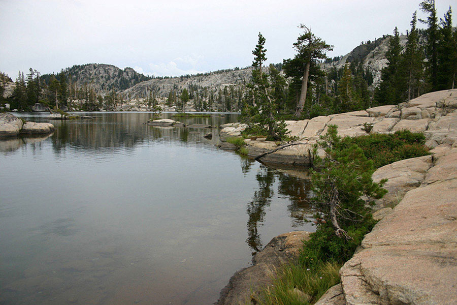
Paradise Lake Photo by Mike White
From the saddle above the east shore of Paradise Lake, look for a large cairn at the head of a rock slot that signifies the beginning of the ducked cross-country route down to Warren Lake. Head south from the saddle on an angling descent across the headwall of Warren Lake’s cirque to a slightly rising traverse below the base of some steep cliffs. Drop down some steep rocks and then follow a rocky swale through shrubs to easier terrain below, where the route bends left to avoid some talus. Continue the descent over rock slabs interspersed with sandy patches through waist-high shrubs toward the tree-lined southwest shore. Nearing the lake, very briefly follow an alder-lined stream to a secluded campsite and proceed a very short distance to the use trail that hugs the shoreline. Head right (east) on the use trail and stroll past several campsites and over a couple of tiny streams to the midpoint of Warren Lake’s south shore (7,259'; 39.39500°N, 120.35103°W), where a maintained trail resumes in an attack of the steep, 1,000-foot slope above.
Leaving the south shore of Warren Lake, one of the steepest miles of trail in the greater Lake Tahoe region winds tightly up a bedrock gully toward a high saddle in the ridge directly southwest of Peak 8,488. Complicating matters somewhat, the trail is quite rocky in places, providing laboring hikers with poor footing for a steep ascent. By getting an early start, at least the seemingly interminable climb can be done under shade and the relatively cool temperatures of morning. After cresting the lip of the basin, a more moderate climb over the last 150 vertical feet leads across drier slopes with widely scattered mountain hemlocks and western white pines. Persistence is finally rewarded at the saddle with an impressive view to the south of North Fork Prosser Creek’s sweeping basin arcing past Basin Peak and the impressive battlements of Castle Peak to Frog Lake Overlook, and also westward down the creek’s verdant canyon to Carpenter Valley. At the saddle a use trail veers left, petering out before reaching an exposed overlook of the canyon below, including an inviting-looking pond surrounded by lush greenery.
Turn right (west) at the saddle and follow a more reasonably graded trail to the crest of a ridge and across an open, flower-filled slope to a junction with the trail to Devils Oven Lake. A sign at the junction provides this ominous warning for those bound for the lake: ROUGH TRAIL.
To reach Devils Oven Lake, turn sharply right (north), away from the Warren Lake Trail, and follow the Devils Oven Lake Trail on a climb to a level area on the crest of a ridge. Close attention must be paid here, as the more obvious route on the ground leads not to the lake but on an arcing traverse on abandoned roads around the north and east sides of Basin Peak to a connection with the PCT southwest of the summit (a route that seems to be increasingly popular with the equestrian crowd). The deteriorating route to Devils Oven Lake heads north from the level area on a curving descent that bends northwest before arriving at the southeast shore (7,918'; 39.38950°N, 120.35646°W). Campsites appear to be more limited here than at the neighboring lakes, a testament to the fact that most backpackers are unwilling to make the steep climbs out of both Devils Oven and Warren Lakes.
DAY 3 (Devils Oven Lake to Castle Peak Trailhead, 8.9 miles): Return to the junction between the Devils Oven Lake and Warren Lake trails. From the junction, turn right (south) to begin an undulating 2.5-mile traverse of the head of North Fork Prosser Creek’s upper basin, across flower-filled slopes and several willow-and-flower-lined streams. Over the course of this traverse between the junction and the saddle below Frog Lake Overlook, the trail gradually curves east as it gains and loses a considerable amount of elevation due to the uneven terrain of the upper basin. After crossing the last stream in Coon Canyon, the trail begins a final, stiff climb toward the saddle. You reach a junction at a small flat on top of a ridge midway through this climb, where an old, lesser-used trail heads left (east) to the formerly privately owned environs around Frog Lake (the area was recently acquired by the Truckee Donner Land Trust). You go right (south). After the brief respite, the gently rising trail leads across a stream before a steep, winding climb to a junction on the saddle below Frog Lake Overlook. The short path on the left (east) to the overlook shouldn’t be missed, as the view straight down Frog Lake Cliff to the lake is a dramatic sight.
Return to the main trail and turn left (south) back onto the Warren Lake Trail. After the previous undulating route across North Fork Prosser Creek’s basin, you’re grateful to find that the trail from the saddle is all downhill back to the parking lot. Initially, the trail follows a gentle-to-moderate descent across a slope covered with acres and acres of mule ears—a beautiful sight at peak bloom—before a steeper descent leads back into the cover of mixed forest. Amid the trees, the trail crosses several trickling, flower-lined little streams on the way to an extensive clearing covered with wildflowers and shrubs that grants one last expansive vista—this one of the Carson Range to the east and the Donner Pass peaks to the south. Returning to a shady forest, the trail makes a winding descent down to a junction with the Donner Lake Rim Trail. On the left, the short lateral heads eastward to tree-rimmed Summit Lake, while the right-hand trail provides a connection to the PCT. Backpackers reluctant to end their journey may find reasonable campsites at this popular lake.
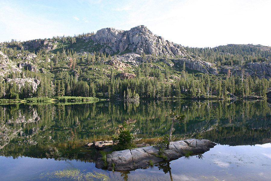
Warren Lake Photo by Mike White
Go right (west) from the Summit Lake junction and continue through the forest cover, broken momentarily by a substantial, open meadow thick with flowers and willows. The forest thins for a while again where the trail passes through an area sprinkled with granite boulders and slabs as the trail makes its way to closing the loop at the junction with the PCT. From there, turn right (south-southeast) to retrace your steps 1 mile to the parking lot.