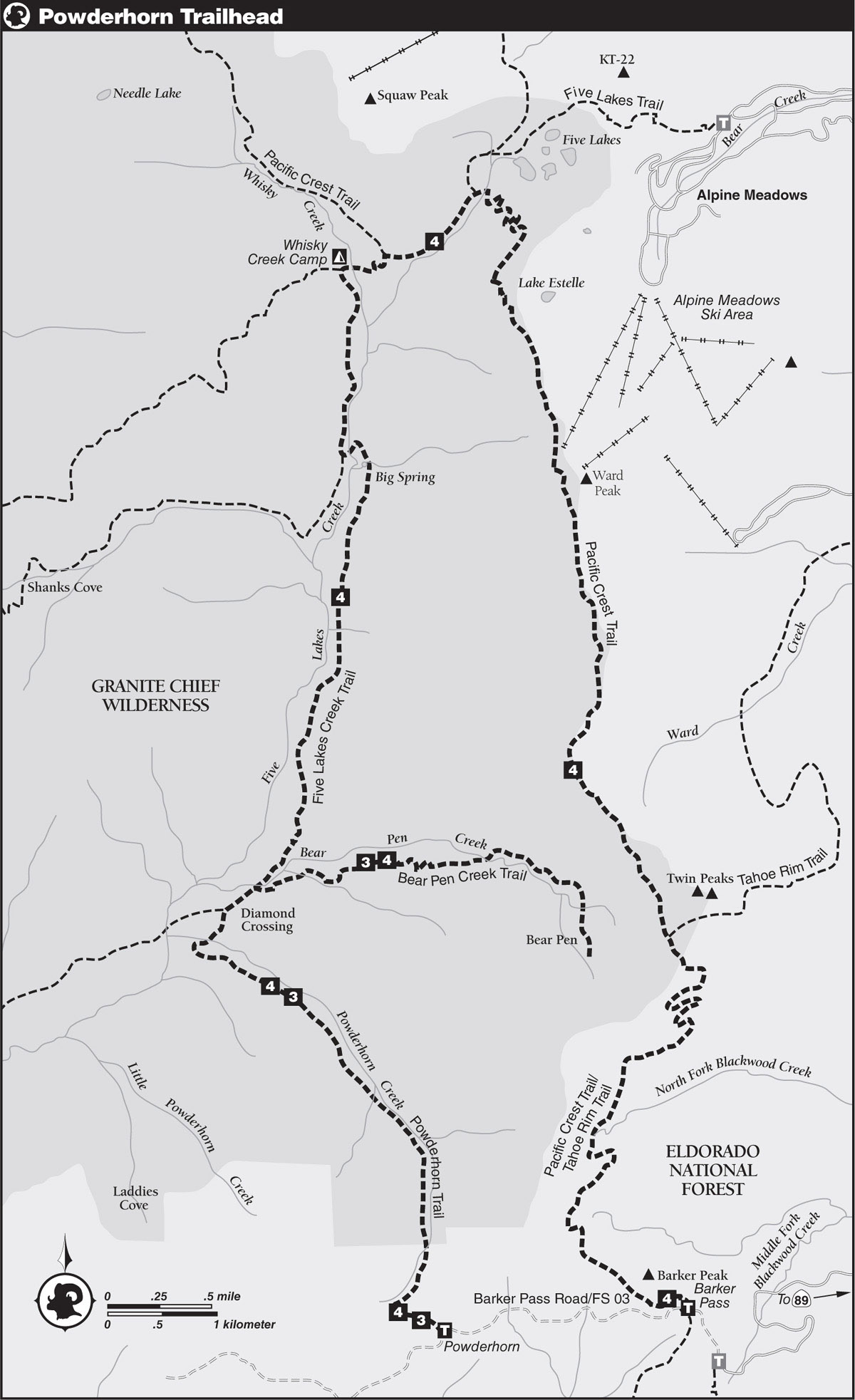
INFORMATION AND PERMITS: Granite Chief Wilderness is in the Tahoe National Forest: 631 Coyote St., Nevada City, CA 95959; 530-265-4531, fs.usda.gov/tahoe. You don’t need a wilderness permit for overnight travel, but you do need a California Campfire Permit for campfires and stoves. Currently, dogs are banned from fawning areas from May 15 to July 15; check with Tahoe National Forest for details.
DRIVING DIRECTIONS: From CA 89, about 4 miles south of its junction with CA 28 in Tahoe City, turn west onto Barker Pass Road (Forest Service Road 03), marked SNO-PARK and KASPIAN CAMPGROUND. Follow FS 03 along the north side of the valley, bend left to cross Blackwood Creek near the 2-mile mark, and then continue up the south side of Blackwood Canyon to the PCT trailhead parking area near Barker Pass (7,673'; 39.07698°N, 120.23509°W), 7 miles from CA 89. To get to the Powderhorn Trailhead, continue downhill from Barker Pass another 1.5 miles to the signed Powderhorn Trailhead (7,654'; 39.07467°N, 120.26134°W), where limited parking is available for two or three vehicles.
trip 3 Bear Pen
Trip Data: |
39.11187°N, 120.24570°W; 13.5 miles; 2/1 days |
Topos: |
Wentworth Springs |
HIGHLIGHTS: Follow a pair of delightful streams to a secluded basin rimmed by granite cliffs on the eastern fringe of Granite Chief Wilderness.
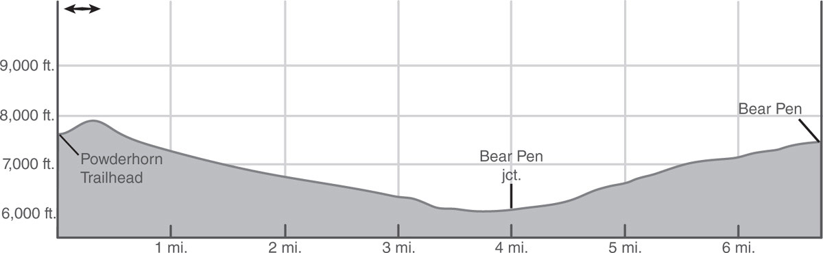
DAY 1 (Powderhorn Trailhead to Bear Pen, 6.75 miles): From the trailhead, make a short climb through selectively logged fir forest to a switchback and continue to where the route merges with a dirt road on the way to the top of a hill. As the road bends left, proceed ahead toward a cairn, where the singletrack trail begins a protracted drop into the canyon of Powderhorn Creek. Follow this steep, winding descent into the trees, soon crossing the nascent, flower-lined stream and proceeding downstream.
Continue the descent past the signed Granite Chief Wilderness boundary down Powderhorn Creek’s canyon. Along the descent, avalanche swaths have thinned the forest enough in spots to allow a profusion of wildflowers, plants, and shrubs to flourish. Amid a thickening forest, cross a narrow stream flowing through a tangle of alders and colorful wildflowers and proceed on a gentle-to-moderate descent down the canyon. The grade eventually eases where the trail crosses a wildflower-carpeted meadow and then encounters a boulder-hop ford of Powderhorn Creek (may be difficult in early season). There’s a marginal campsite near the crossing.
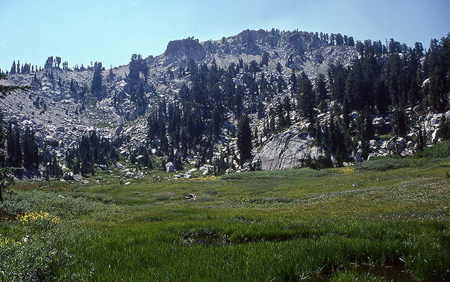
Lovely Bear Pen in the Granite Chief Wilderness Photo by Mike White
Heading northeast, the trail proceeds through the trees for about 300 yards to the open meadow known as Diamond Crossing. Pass by a marked junction in this meadow, where a very faint trail (the old Hell Hole Trail) heads southwest toward a trailhead near Hell Hole Reservoir. Bear right (northwest) at this junction to continue through the meadow, and then reenter forest on the way to a second junction, this one with a slightly more distinct trail heading up the canyon of Bear Pen Creek.
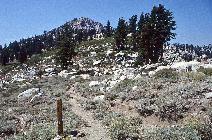
Turn right and head east on the Bear Pen Creek Trail on a moderate climb up a canyon filled with thick forest. The trail to Bear Pen is infrequently used, and the tread tends to falter crossing a small meadow. After 2.75 miles from the last junction of the mostly forested trail, reach a willow-and-grass-filled meadow known as Bear Pen (7,424'; 39.11187°N, 120.24570°W), an opening in the thick forest backdropped by a dramatic amphitheater of cliffs. Little-used, hemlock-shaded campsites around the meadow’s perimeter offer secluded camping to solitude seekers. With a little luck, visitors may also see a namesake critter or two.
DAY 2 (Bear Pen to Powderhorn Trailhead, 6.75 miles): Retrace your steps.
trip 4 Barker Pass

Trip Data: |
39.16627°N, 120.27192°W (Whiskey Camp Creek); 25.0 miles (shuttle) or 26.5 miles (loop); 3/1 days |
Topos: |
Wentworth Springs, Granite Chief, Tahoe City, Homewood |
HIGHLIGHTS: On the first part of this journey, backpackers are treated to a shady, old-growth forest that escaped the axes of the lumbermen who denuded the Tahoe Basin of most of its timber during the Comstock Lode frenzy in the 19th century. Secluded camping, colorful wildflowers, and dancing streams are delightful attractions. The second part of the trip follows a section of the Pacific Crest Trail (PCT) on a ridge route that offers sweeping vistas. To do this trip as a loop, see the directions.
HEADS UP! The heart of Granite Chief Wilderness is a lonely parcel of land where little-used trails can disappear in grassy meadows—make sure you carry a map and compass.
SHUTTLE DIRECTIONS: If taking the shuttle trip between the Powderhorn Trailhead and the Barker Pass Trailhead, leave your first car at the Barker Pass Trailhead (7,673'; 39.07698°N, 120.23509°W) and your second at the Powderhorn Trailhead (7,654'; 39.07467°N, 120.26134°W), 1.5 miles farther west down Barker Pass Road.
DAY 1 (Powderhorn Trailhead to Bear Pen, 6.75 miles): From the Powderhorn Trailhead, climb on the trail to a dirt road and follow that road to a bend where the marked route continues ahead. Descend the old roadbed to a sharp curve, where a trail marker directs hikers to veer left (generally north) onto singletrack trail. Make a steep, winding descent to another dirt road, which you briefly follow until the singletrack trail resumes. Continue on this trail to the wilderness boundary and then down Powderhorn Creek’s canyon to the junction with the Bear Pen Creek Trail. Turn right and take this trail 2.75 miles to Bear Pen (7,424'; 39.11187°N, 120.24570°W).
DAY 2 (Bear Pen to Whisky Creek Camp, 7.0 miles): Retrace your steps 2.75 miles to the junction of the Bear Pen Creek and Five Lakes Creek trails. From the junction, turn right and head north on the Five Lakes Creek Trail, immediately encountering the crossing of Bear Pen Creek. Beyond the crossing, briefly follow alongside the alder-lined course of Bear Pen Creek until it bends eastward, and then proceed up the trail in forested Five Lakes Creek’s canyon. Cross the rocky channel of the seasonal outlet from Grouse Canyon and then continue another quarter mile to a rivulet.
Another half mile from the rivulet leads to a signed junction just before a good-size meadow. The signed trail to Whisky Creek Camp is virtually impossible to follow. Therefore, continue straight ahead (north), following signed directions for Big Spring.
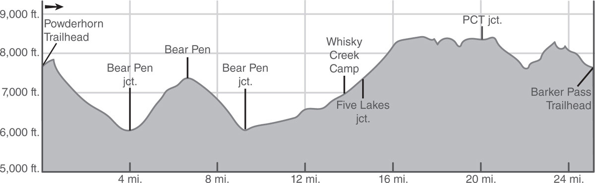
Crossing the meadow north of the junction, the tread may be difficult to follow through the tall grasses, but a distinct path reappears where the trail reenters the forest. From the meadow, an easy half mile leads to Big Spring at the south end of a large meadow; nearby conifers harbor campsites. Although the defined trail disappears in the meadow grass beyond the spring and the campsites, the trail resumes at the west edge of the meadow, about midway through the clearing and shortly to a ford of Five Lakes Creek and then to a junction (39.14986°N, 120.27241°W).
Turn right (north) at the junction and follow the west side of alder-lined Five Lakes Creek for 0.3 mile and then cross a side stream. Beyond this stream, climb moderately to the forested flat that harbors Whisky Creek Camp (6,927'; 39.16627°N, 120.27192°W). Observe posted regulations here.
DAY 3 (Whisky Creek Camp to Barker Pass, 11.25 miles, or to Powderhorn Trailhead, 12.75 miles): From Whisky Creek Camp, head east a short distance to the crossing of Five Lakes Creek, and then make a 0.3-mile switchbacking climb through the trees to a T-junction with the PCT. Turn right at the junction, following signed directions for the Alpine Meadows Trailhead, and proceed on the PCT on a moderate climb through a gradually lightening forest, where shrubs and wildflowers become more and more prominent. Follow occasional switchbacks up the left-hand side of Five Lakes Creek canyon across initially dry slopes, followed by a hillside of flourishing wildflowers and willows. Beyond this incredibly verdant hillside, where conifers start to reappear, is a signed junction with a lateral to Five Lakes. (Backpackers seeking campsites must find one at least 600 feet away from any of the lakes in the Five Lakes basin.)
From the junction with the Five Lakes lateral, veer right (east), remaining on the PCT, and follow the gently graded trail across a meadow sprinkled with lodgepole pines and firs to a boulder hop of Five Lakes Creek. From the crossing, climb an open hillside carpeted with patches of alder and willows and interspersed with a fine assortment of wildflowers, including delphinium, yarrow, paintbrush, aster, corn lily, and daisy. Beyond this colorful area, many long switchbacks zigzag up a forested hillside toward the crest of the ridge above. Before the end of these switchbacks, thinning trees allow the first of many sweeping views to come: Squaw Peak is the prominent mountain to the northwest, and below to the west is the heart of Granite Chief Wilderness; farther on, where the switchbacks end and the trail approaches the crest, views expand to the south of peaks in Desolation Wilderness, along with a varied assortment of communications equipment and ski lift machinery littering the summit of Ward Peak directly ahead. When the trail reaches a small saddle, the views include Lake Tahoe and Alpine Meadows to the east.
Granite Chief Photo by Mike White
With the stiff climbing behind you, traverse around Peak 8,474 to a second saddle, pass by a snow fence built to minimize cornices overhanging the ski slopes of Alpine Meadows, and continue through low-growing flowers and shrubs across the west side of Ward Peak, enjoying continuous views of the surrounding terrain along the way. Beyond Ward Peak, the PCT reaches two more saddles before dipping below impressive-looking volcanic cliffs on the west side of Peak 8,522.
Briefly enter a grove of western white pines, firs, and hemlocks, the first significant pocket of forest since the switchbacks above the crossing of Five Lakes Creek. Leave the trees for a while to regain the crest and enjoy fine views of Ward Canyon and Lake Tahoe to the east and ahead to Twin Peaks. Then head back into the trees, where a subsidiary ridge abuts the main crest, and follow a pair of short switchbacks on a brief climb back to the top of the shrub-covered ridge.
Continue along the ridge, where waist-high tobacco brush threatens to overgrow the path in places and where proclaiming the expansive views along this part of the journey becomes redundant. Eventually, the views diminish as the trail follows a gentle grade through mixed forest to a junction with the Tahoe Rim Trail (TRT) just southwest of Twin Peaks.
From the junction, the PCT and TRT share a similar course for many miles, almost to Carson Pass. Initially the trail continues through the trees, but eventually it emerges into the open again with excellent views of Twin Peaks and Blackwood Canyon. In order to avoid a knife-edge ridge, the trail next makes several long switchbacks down into the canyon of North Fork Blackwood Creek. The switchbacking trail loses 600 feet of elevation before ultimately climbing back out of the canyon. The trail crosses a few lushly lined streams and seeps along the way, all tributaries of North Fork Blackwood Creek, where a limited number of nearby campsites serve overnighters.
CLIMBING TWIN PEAKS
Peak baggers can easily add a notch to their belts by heading east from the junction on the TRT to a use trail that ascends the east ridge of the easternmost of Twin Peaks’ summits. The route climbs steeply up the ridge, offering excellent views of Lake Tahoe, the summits of Desolation Wilderness, and the surrounding canyons along the way, culminating in an even more impressive 360-degree view from the top.
A short but stiff climb from the campsites leads to the top of a ridge directly west of Peak 8,355. An extremely short use trail leads to a scramble of this volcanic pinnacle, where hikers can enjoy fine views of the surrounding terrain.
Away from the ridge, the trail traverses the head of a canyon of a subsidiary stream of Middle Fork Blackwood Creek, passing in and out of a light fir forest. Good views of Lake Tahoe, Barker Peak, and Ellis Peak are available along the way through gaps in the forest. A final, moderate descent across the south slopes of Barker Peak leads to the Barker Pass Trailhead (7,673'; 39.07698°N, 120.23509°W), where your shuttle ride should be waiting.
If you are doing the loop option, add 1.5 miles to your day and close the loop by turning right and descending generally west on Barker Pass Road to the Powderhorn Trailhead (7,654'; 39.07467°N, 120.26134°W).