
INFORMATION AND PERMITS: All backpackers must secure and pay for a wilderness permit for entry into Desolation Wilderness. The region is heavily used, and strict quotas are in place for the number of overnighters departing from every trailhead that enters the wilderness. A majority of permits are available by reservation, with the remainder handed out on a first-come, first-served basis. Reserved permits may be obtained online at recreation.gov. During business hours, walk-in permits may be picked up at the Taylor Creek Visitor Center, Pacific Ranger Station, LTBMU Supervisor’s Office, and LTBMU North Shore Office.
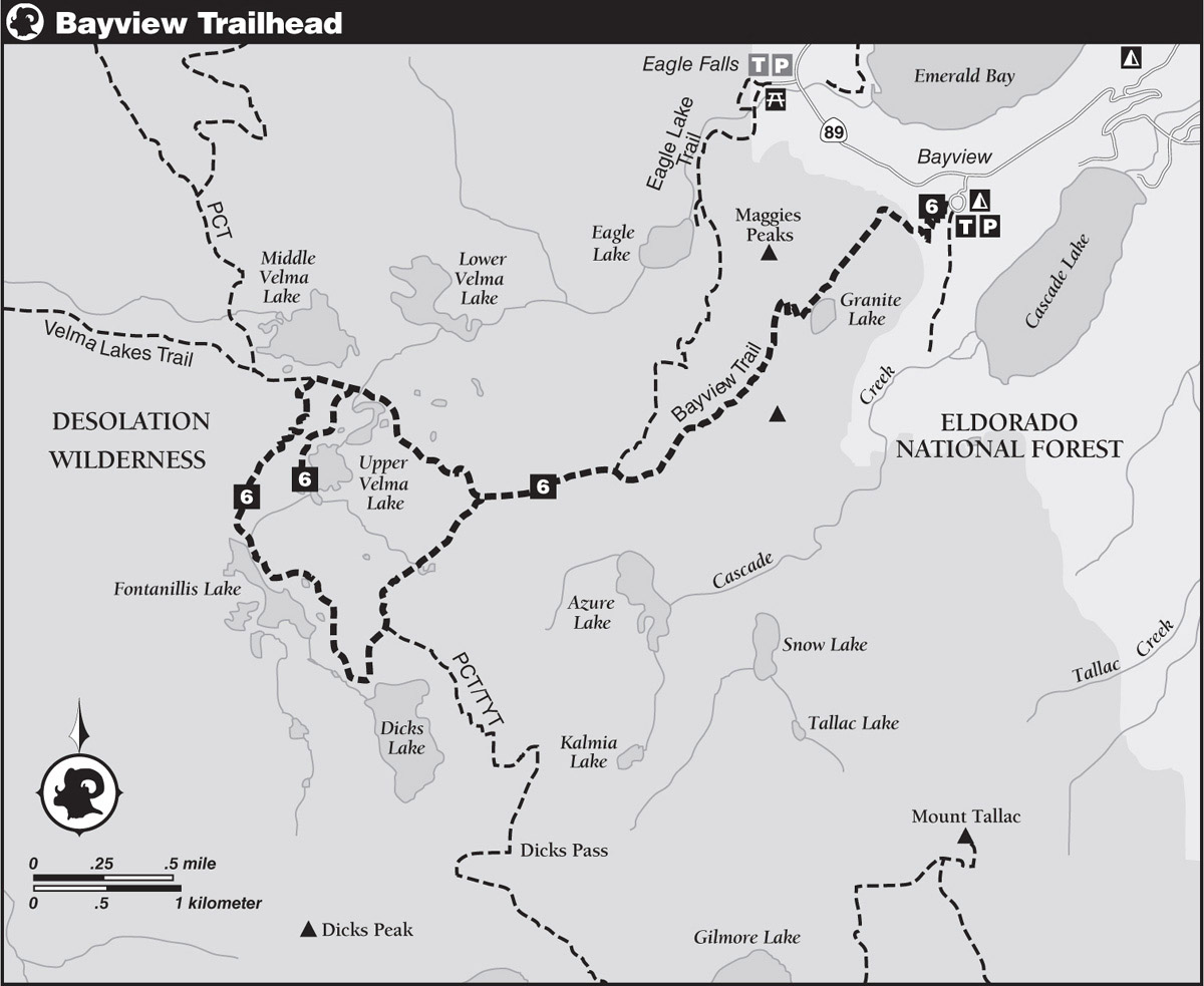
DRIVING DIRECTIONS: Follow CA 89 to Emerald Bay and find the turnoff for the Bayview Campground and Trailhead on the south side of the highway, approximately 7.5 miles from the junction of US 50 in South Lake Tahoe, or 19.5 miles south from the junction of CA 28 in Tahoe City. The trailhead is at the south end of Bayview Campground.
trip 6 Velma, Fontanillis, and Dicks Lakes

Trip Data: |
38.92595°N, 120.15068°W (Upper Velma Lake); 11.8 miles; 2/1 days |
Topos: |
Emerald Bay, Rockbound Valley |
HIGHLIGHTS: This hike through the heart of Desolation Wilderness visits several cirque-bound lakes surrounded by the characteristic granite terrain for which the area is renowned.
DAY 1 (Bayview Trailhead to Upper Velma Lake, 4.7 miles): Soon after leaving the trailhead, turn right to go generally southwest at a junction with the trail on the left to Cascade Lake. Follow a steep, switchbacking climb through mixed forest. After crossing the Desolation Wilderness boundary, follow the crest of a ridge, from where good views of Emerald Bay and Lake Tahoe appear through gaps in the forest. Leave the ridge and follow the alder-lined outlet of Granite Lake on a gentle ascent through lush foliage, reaching the hillside above Granite Lake. To visit the lake, drop down to the shoreline via one of the use trails on the northwest side.
Well above the far end of the lake, the Bayview Trail begins a steep, switchbacking climb across the south-facing slope below Maggies Peaks. Exiting Granite Lake’s basin, the grade mercifully eases to a gentle stroll along the back side of South Maggies Peak, followed by a gentle descent along the forested southwest ridge. You reach a junction with the Eagle Lake Trail at a saddle, 2.7 miles from the trailhead (8,179'; 38.92833°N, 120.12703°W).
Turn right (generally west) at the junction and follow sandy tread on a gently undulating route through scattered conifers and around granite boulders and slabs for 0.6 mile to a junction with the Velma Lakes Trail (8,228'; 38.92644°N, 120.13714°W).
Bear right (north-northwest) here and descend, with occasional glimpses through scattered pines of the unnamed pond directly north of Upper Velma Lake. Reach the floor of the basin and follow the north shore of the pond to a ford of the outlet and to a junction just beyond, 4.1 miles from the trailhead. Turn left (south) and proceed 0.6 mile to campsites near the inlet on the southwest shore of Upper Velma Lake (7,966'; 38.92595°N, 120.15068°W).
DAY 2 (Upper Velma Lake to Bayview Trailhead, 7.1 miles): Retrace your steps 0.6 mile to the last junction and turn left (west) to make a short climb to a junction with the Pacific Crest Trail (PCT) (7,958'; 38.93346°N, 120.14898°W). (To see Middle Velma Lake, continue west on the PCT a short distance to a fine viewpoint. A number of pleasant and popular campsites on the south shore are easily reached cross-country from the PCT.)
To continue the loop part of this trip, follow the PCT south-southwest on a moderate, winding climb along a forested ridge above the west shore of Upper Velma Lake. Eventually, Dicks Pass and Fontanillis Lake pop into view as the trees thin and the grade eases. A short drop leads to the crossing of Fontanillis Lake’s outlet, followed by a traverse across the east side of the lake’s multihued rock basin, which lies in the shadow of towering Dicks Peak. Legal campsites are absent on the trailside of the lake, but open benches above the west shore provide a number of excellent opportunities for overnight accommodations.
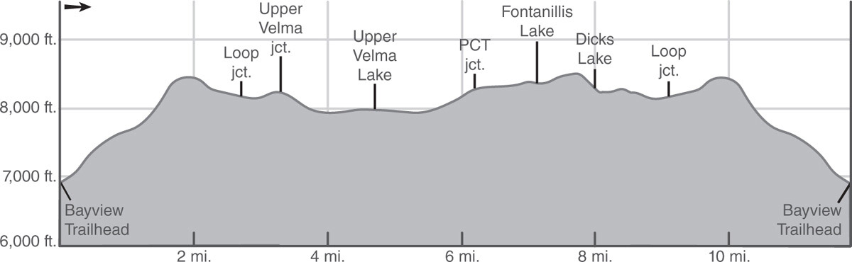
Leaving Fontanillis Lake, a brief ascent across boulder-covered slopes leads to the top of a rise and a junction with a 100-yard lateral right (south) to Dicks Lake. Backpackers will find excellent, although popular, campsites on the north shore and east peninsula of Dicks Lake.
Assuming you don’t take the lateral, the PCT heads left (generally north), away from Dicks Lake, on an easy ascent to a junction where the PCT and the Tahoe-Yosemite Trail (TYT) turn right (southeast) toward Dicks Pass. You go ahead here (north) to descend moderate switchbacks to the floor of a pond-dotted basin, and then traverse the basin northeastward to the junction of the Eagle Lake and Velma Lakes Trails, closing the loop part of this trip.
From there, turn right (east) and retrace your steps 2.7 miles past Granite Lake to the Bayview Trailhead.

A glorious view of Lake Tahoe and Emerald Bay from the trail to Velma Lakes Photo by Mike White