
INFORMATION AND PERMITS: “Meiss Country” is the current term for this area in the Lake Tahoe Basin Management Unit. For information: USDA Forest Service, Lake Tahoe Basin Management Unit; 35 College Dr., South Lake Tahoe, CA 96150; 530-543-2600, fs.usda.gov/ltbmu. No wilderness permits are required at this time, but you must have a California Campfire Permit to have a campfire or use a stove.
DRIVING DIRECTIONS: Follow US 50 to Echo Summit. From there go west to a paved access road on the south side of the highway, 0.2 mile west of Echo Summit. A sign for Adventure Mountain Lake Tahoe resort marks the turnoff. Proceed 0.2 mile to the large Pacific Crest Trail (PCT) parking lot.
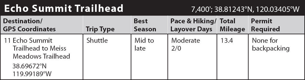
trip 11 Echo Summit Trailhead to Meiss Meadows Trailhead

Trip Data: |
38.69672°N, 119.99189°W; 13.4 miles; 2/0 days |
Topos: |
Echo Lake, Caples Lake, Carson Pass |
HIGHLIGHTS: This second leg of the unofficial Tahoe-Yosemite Trail (TYT) begins with an unpromising walk through a summer-dusty winter recreation area just south and west of Echo Summit (on US 50). But soon you leave this behind for the remarkable scenery of Meiss Country, where seasonal wildflowers from here to Carson Pass can be amazing at peak bloom. This section coincides with the Pacific Crest Trail (PCT).
HEADS UP! Hunters also favor this area: when hiking during deer season, wear bright clothing and stay near major trails.
SHUTTLE DIRECTIONS: To get to Meiss Meadows Trailhead, take CA 88 to Carson Pass and go 0.3 mile west to a large parking lot on the highway’s north side that serves this trailhead. There is a daily fee of $5 to park here.
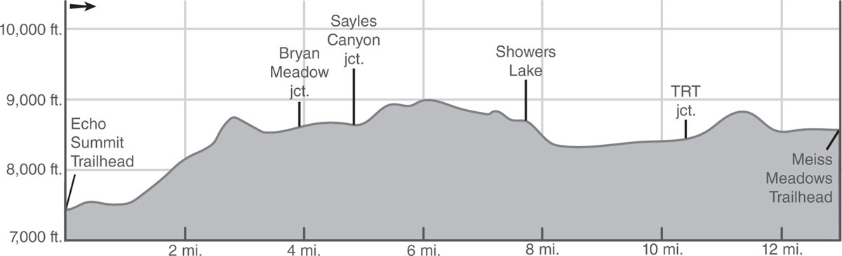
DAY 1 (Echo Summit Trailhead to Showers Lake, 8.3 miles): First, walk a short way down the paved road (south) from the parking lot and then through the ski area to pick up the trail on the snow park’s south edge. You’ve just passed through an old ski area, now Adventure Mountain Lake Tahoe resort. The former ski lodge now houses a unit of the California Conservation Corps.
Start hiking through shrubs and low pines, immediately crossing a section of old paved roadway, and then making a moderate climb of the old ski hill. The route, well signed, levels, merges with an old road for a short distance, and then veers right (south) on well-marked, singletrack trail. Follow the rocky trail up a shrub-covered slope to intersect a sandy road, and then turn right and climb up the road about 100 yards to the resumption of singletrack trail at a Tahoe Rim Trail sign.
Swinging south, stroll along granite-dotted slopes sparsely covered by white firs and lodgepole and Jeffrey pines, with a generous understory of huckleberry oak bushes. Approximately 1 mile from the parking lot, a momentary descent leads past a lateral heading northeast to an unnamed pond; go right (west) here to Benwood Meadow, which can dry up by late season.
Proceed through the forest around the edge of the usually boggy meadow and across a pair of seasonal streams to a wood-plank bridge over an alder-lined creek. After a moderate, winding climb from the bridge, the trail switchbacks and ascends into thinning forest, which allows periodic glimpses of Lake Tahoe over the next mile or so. Continue the moderate climb to the south past large granitic boulders.
Reach a saddle about 1.5 miles from Benwood Meadow, where an excellent view to the southeast includes the Upper Truckee River basin and surrounding peaks as well as Elephants Back and Round Top. Past the viewpoint, continue climbing for another 0.3 mile, staying at the foot of a row of nearly vertical cliffs, and reach a tiny creek. Half a dozen people could camp on the flat above the creek’s southeast bank. From the vicinity of this campsite, the trail switchbacks and climbs quite steeply to a hillside meadow with water and a campsite on a rise near the creek.
The grade soon eases upon entering a dense-to-moderate lodgepole forest as the trail crosses a ridge and descends gently to a shallow pass. Just beyond the pass, reach a junction with the Bryan Meadow Trail near the east end of the picturesque clearing. Nearby are several campsites with water plentiful in early season. Go left (ahead, south) here, staying on the PCT/TYT.
From Bryan Meadow, the trail leads south on sandy footing, undulating and then ascending gently to a minor summit, followed by a brief descent to a saddle and a junction with the Sayles Canyon Trail. Again, go left (ahead, south) here on the PCT/TYT.
A mile of gradually increasing ascent leads over the east ridge of Peak 9,020, which separates the two branches of the headwaters of Sayles Canyon Creek. At the upper lobes of a hillside meadow, there may be water into late season and campsites on a sandy rise nearby. At the first saddle beyond the ridge, a use trail crosses the PCT/TYT at right angles, and a short distance farther on is a junction with an infrequently maintained trail to Schneider’s cow camp. Once more, go left (ahead, south) here on the PCT/TYT.
The trail next curves through a willow-covered meadow and crosses its larger, flower-covered neighbor; both may provide late-season water. Keen eyes will begin to notice how the character of the rocks begins to change from granitic to volcanic and the sandy tread turns pinkish.
A descent leads into a large bowl whose southwest rim may be draped with snow cornices for much of the summer. The slopes of this bowl are very open and laced with runoff streams, which support lavish gardens of shrubs and flowers, including blue elderberry, rangers buttons (also called swamp whiteheads), mountain bluebells, green gentian, aster, wallflower, penstemon, cinquefoil, spiraea, corn lily, and columbine. This highly colorful bowl, harboring as-yet-unseen Showers Lake, offers photographers a great choice of hues, subjects, and compositions.
Make a gentle descent through the bowl, passing beneath a palisade-like outcropping below the cornice-laden rim. The trail, which here differs from the route shown on the topo, veers northeast and eventually drops below Showers Lake to cross the lake’s outlet. Beyond the ford, zigzag steeply uphill south-southwest a short distance to Showers Lake (8,658'; 38.74251°N, 120.03419°W).
DAY 2 (Showers Lake to Meiss Meadows Trailhead, 5.1 miles): Heading toward CA 88, the trail climbs as it curves around the lake’s east side to a junction at a small saddle above Showers Lake. Take the left fork southeast and away from the lake (the right fork is a seldom-used lateral to Schneider’s cow camp). Descend a switchback and drop down a slope with vegetation and colors much like the previous bowl. This trail segment offers panoramic views of the large meadows around the headwaters of the Truckee River. The best views occur when there’s just a bit of snow left on the west side of the Crystal Range.
Make a steady descent to traverse another meadow and reenter forest on the west slope of the Upper Truckee River valley. The trail begins to resemble an old four-wheel-drive road, which it once was, on the way past a large pond. Just north of your first ford of the Truckee River, a use trail heads roughly north-northeast across Meiss Meadows a half mile to Meiss Lake. Reaching the lake in early season may be a bit of a challenge, as parts of the trail are quite mucky and the ford of the creek on the way to the lake will most likely be a wet one. You, however, stay on the main PCT/TYT and ford the young Upper Truckee River.
MEISS MEADOWS
During the last ice age, a lake occupied all these meadows, which subsequently were filled with sediment—except for the small remnant of Meiss Lake. The meadows offer many attractions for the birder and also for those who wish to see Belding’s ground squirrels. The house and barn are the remains of a former cow camp—thank goodness, grazing here was banned several years ago.
Near the buildings is a defunct stock gate and a well-signed junction with the Tahoe Rim Trail heading left (northeast) to Round Lake. Go ahead (south) to stay on the PCT/TYT. Beyond this junction, the PCT/TYT fords the river again and begins a final, moderate ascent to a saddle dividing the Truckee River and American River drainages. On the climb, increasingly fine views culminate at the saddle, with the Round Top complex dominating the scene immediately to the south, Lake Tahoe capturing the eye in the distance to the north, and Red Lake Peak towering immediately to the east (you’re on its western slope).
From the saddle, the route descends steeply on the rocky-dusty tread of a former jeep road. After several hundred yards, the trail veers left (east) and follows a few switchbacks down sagebrush-covered slopes dotted with mule ears and a variety of other flowers. Follow the trail across a runoff stream and then around the nose of a ridge through a moderate forest cover of fir and pine.
Soon the sound of cars on CA 88 below heralds the approach to Meiss Meadow Trailhead. The final leg takes longer than you’d expect because the trail curves well to the east before exiting at the trailhead parking lot (8,560'; 38.69672°N, 119.99189°W) just off the noisy road.