INFORMATION AND PERMITS: You must have a wilderness permit for overnight visits to this part of Carson-Iceberg Wilderness. This trip is in the Stanislaus National Forest: Calaveras Ranger District, PO Box 500, Hathaway Pines, CA 95233; 209-795-1381, fs.usda.gov/stanislaus.
DRIVING DIRECTIONS: From the east end of Lake Alpine, travel 6 miles northeast up CA 4, or, from Ebbetts Pass, drive 8.4 winding miles west (just west of Pacific Grade Summit), to the west end of Mosquito Lakes (a single lovely pond at high water, or a pair of attractive ponds at low water) and the signed trailhead. There’s a vault toilet in the Mosquito Lakes Campground across the highway.
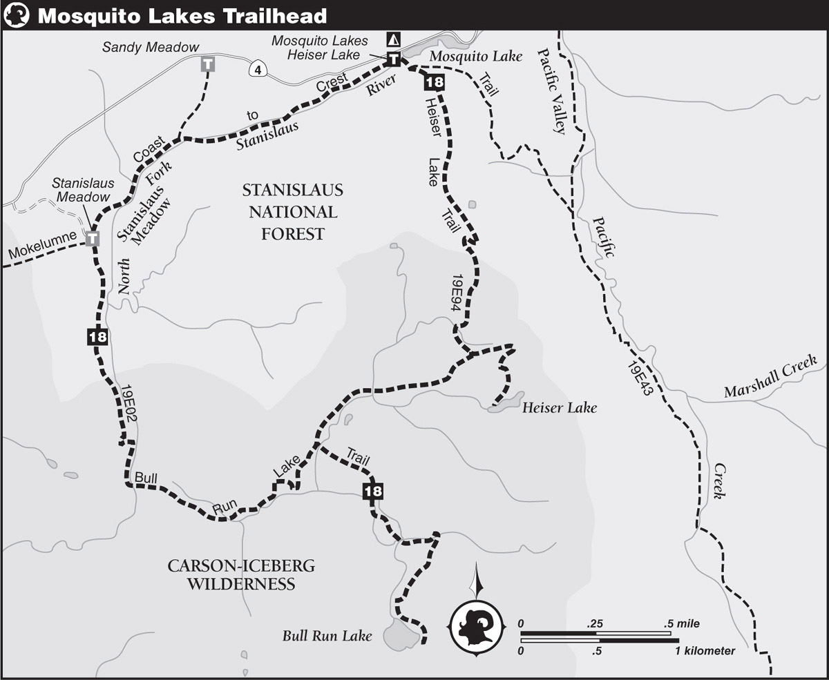
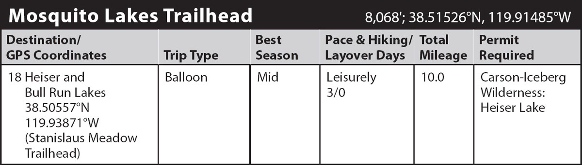
trip 18 Heiser and Bull Run Lakes

Trip Data: |
38.50557°N, 119.93871°W (Stanislaus Meadow Trailhead); 10.0 miles; 3/0 days |
Topos: |
Pacific Valley, Spicer Meadow Reservoir |
HIGHLIGHTS: You’ll visit two of the better, scenic, trout-stocked lakes off CA 4 on this easy hike. Day hikers and anglers may choose to hike only to Heiser Lake via the Heiser Lake Trail (Mosquito Lakes Trailhead), or only to larger Bull Run Lake via the Bull Run Trail (Stanislaus Meadow Trailhead).
DAY 1 (Mosquito Lakes Trailhead to Heiser Lake, 2.0 miles): Head briefly south on the Heiser Lake Trail, almost immediately meeting a junction with the Emigrant and Mokelumne Coast to Crest Trails on the right heading west to Lake Alpine (not shown on the topo). Step across the Emigrant Trail and continue ahead (south), remaining on the Heiser Lake Trail and curving around the western Mosquito Lake to a junction marked by a post with the recently designated Mokelumne Coast to Crest Trail on the left. Veering to the right, your trail makes a steep climb up a moraine south of the lake through moderate-to-sparse forest. Gaining the ridge at last, descend the sandy trail and enter Carson-Iceberg Wilderness near the half-mile mark. Continue generally southeast through forest interrupted by a pair of small meadows and then, at 0.75 mile, climb up the next moraine.
On fresh-looking, glacially scoured rock, descend the moraine and follow a winding route that takes the path of least resistance down rock slabs. After leveling off in deep forest, climb 0.3 mile to a small flat and a junction where tomorrow’s route will turn right (southwest) down a creekside trail. For today, you turn left (east) at the junction and make a quarter-mile ascent to a switchback and then climb south over the low granitic ridge that hides shallow Heiser Lake (8,365'; 38.49481°N, 119.90675°W). Dotted with several small granite islands, the conifer-fringed lake presents anglers with a picturesque distraction while they contemplate a meal of fresh trout. Campsites lie on the north and south shores under a pleasant canopy of red firs, lodgepole pines, western white pines, and mountain hemlocks.
DAY 2 (Heiser Lake to Bull Run Lake, 2.5 miles): First, retrace your steps a quarter mile to the trail junction. From here, the route, usually well-blazed and ducked, leads southwest to the brink of a rocky slope and then down the slope on very steep switchbacks. Paralleling Heiser Lake’s outlet, head west across a flat basin shaded by mountain hemlocks. Approaching the basin’s west edge, cross four closely spaced branches of a tributary that joins the outlet creek just south of the trail. After a brief climb west, the trail turns south and leads to a signed junction with the Bull Run Trail.
Turn left (east) at the junction and almost immediately ford Heiser Lake’s outlet, a ford that could present a problem in early season when the creek is a small torrent of whitewater. After following a nearly level granite bench for 0.3 mile, the route angles south to cross the first of many small rivulets. The winding route climbs and gyrates up toward Bull Run Lake from one granite slab to another. Broken into two distinct ascents, the first climb trends southeast up and around a secondary ridge; the second trends southwest past a trailside pond before approaching the outlet and then ascending alongside to the lake’s bedrock dam (8,348'; 38.48193°N, 119.91489°W).
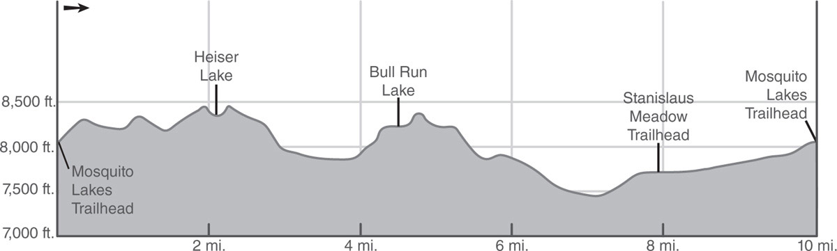
Although not large by Sierra standards, this popular lake can accommodate a large number of campers, particularly on the spacious flats shaded by large red firs. Swimming in the lake is comfortable by early August, and fishing is reported to be good for brook trout.
DAY 3 (Bull Run Lake to Mosquito Lakes Trailhead, 5.5 miles): Backtrack to the trail junction west of Heiser Lake’s outlet and turn left (southwest) onto the Bull Run Trail. Descend, steeply at times, 350 vertical feet down rock slabs covered with lodgepole and western white pines, red firs, and mountain junipers, staying well above the outlet creek from both lakes before the grade eases in a shady flat. A short, forested traverse leads to a crossing of this creek, which may entail a cold, wide, knee-deep ford in early season. Beyond the ford, follow the course of the creek on a shady, long 0.3 mile to a ford of the twin-branched outlet, which may also present early-season challenges. Beyond the ford the trail maintains a westbound course for 100 yards to an even wider ford of the headwaters of North Fork Stanislaus River. A search for logs across this stream may result in a quicker and drier crossing.
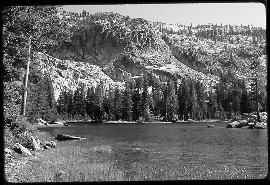
Bull Run Lake Photo by Kathy Morey
Immediately beyond the North Fork, cross a seasonally dry wash before turning north and roughly paralleling the river upstream. A wide path leads up a moderate grade to Stanislaus Meadow, where a chorus of cowbells may herald the presence of cattle munching away on the verdant grasses. A fence helps to keep the cattle in the meadow while the trail follows an easy route through the trees near the west edge for 0.3 mile to the signed Stanislaus Meadow Trailhead (7,776'; 38.50557°N, 119.93871°W).
Away from the trailhead, follow the dirt access road to the left of a barbed wire fence enclosing expansive Stanislaus Meadows to a 3-way junction marked by a post. Turn right onto the combined singletrack of the Emigrant and Mokelumne Coast to Crest Trails and continue along the fenced meadow on gently graded tread, crossing some usually dry seasonal streams on the way through the fringe of a lodgepole pine forest. Beyond the end of the fence, ignore an unmarked dirt trail angling across your path and proceed to a signed three-way junction with a lateral on the left to the Sandy Meadows Trailhead. Continue ahead shortly to a lobe of the meadows and a usually easy crossing of the trickling, nascent North Fork Stanislaus River. Soon the trail begins a moderate climb through a light forest of lodgepole pines, western white pines, and mountain hemlocks. Make another usually easy crossing of the river and continue the ascent. Eventually, the grade becomes steeper and the tread turns rocky just before a level stretch delivers you to the final junction with the Heiser Lake Trail near the highway. From there, turn left and retrace your steps a very short distance to the trailhead.