
INFORMATION AND PERMITS: These trips are in Yosemite National Park: wilderness permits and bear canisters are required; pets and firearms are prohibited. Quotas apply, with 60% of permits reservable online up to 24 weeks in advance and 40% available first-come, first-served starting at 11 a.m. the day before your trip’s start date. Fires are prohibited above 9,600 feet. See nps.gov/yose/planyourvisit/wildpermits.htm for more details.
DRIVING DIRECTIONS: The Sunrise Lakes Trailhead is along Tioga Road (CA 120) at a large pullout at a highway bend near Tenaya Lake’s southwest shore. It is located 30.7 miles northeast of Crane Flat and 8.7 miles southwest of the Tuolumne Meadows Campground. There are pit toilets at the trailhead.
trip 43 Sunrise Lakes and Sunrise High Sierra Camp
Trip Data: |
37.79404°N, 119.43412°W; 10.4 miles; 2/1 days |
Topos: |
Tenaya Lake |
HIGHLIGHTS: This trip follows very popular trails, but the breathtaking scenery you enjoy along the route more than makes up for the lack of solitude. The terrain passed on this quite short hike is varied and scenic, with two superb camping possibilities, the upper Sunrise Lake and Sunrise High Sierra Camp. The former offers sheltered camping beside a scenic subalpine lake, while those at the latter are rewarded with a beautiful sunrise.
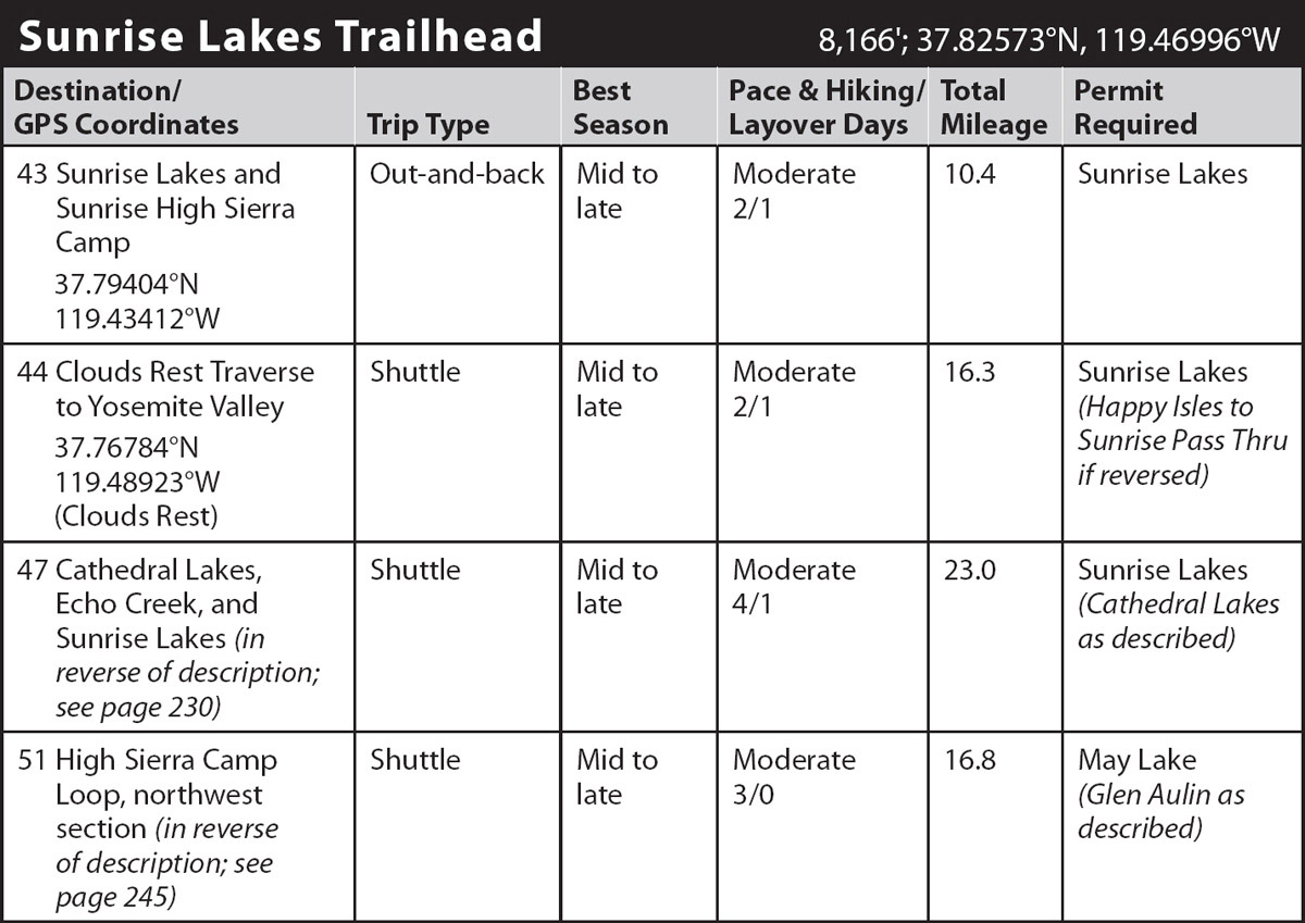
DAY 1 (Sunrise Lakes Trailhead to Sunrise High Sierra Camp, 5.2 miles): From the trailhead parking area, follow the eastbound trail, after a few steps passing a small spur trail that departs to the right (south) toward May Lake and Olmsted Point, then crossing the usually flowing outlet of Tenaya Lake on large rock blocks (an early-season wade). Just beyond this crossing you reach a trail junction, where left (northeast) leads to Tenaya Lake’s southeastern shore, while you go right (south-southwest) toward Sunrise High Sierra Camp. Three hundred feet later is a second junction, where left (north) also leads to Tenaya Lake’s southeastern shore, while you go right (south). The trail briefly parallels Tenaya Creek before veering a little left, gently crossing a minor rise and dropping to a ford of Mildred Lake’s outlet. Beyond, you continue an undulating traverse south in sparse forest. You pass pocket meadows and cross several seasonal tributaries, the Sunrise Lakes outlets, before embarking on a notably steep collection of switchbacks—few Sierra trails ascend 1,000 feet in just 1.1 miles. The trail is also, in places, annoyingly rocky, reflecting the many half-buried boulders and partially submerged slabs with which the trail construction crew had to contend. At least these switchbacks are, for the most part, mercifully shaded, and where they become steepest, they give back with the beauty of astounding views of the surrounding granite landscape as well as a fine wildflower display underfoot. Soon after the hemlock-and-red-fir forest becomes denser, the switchbacks end, and the trail levels out as it arrives at a junction on a shallow, forested saddle, 2.5 miles from the trailhead. Here you turn left (east), while the Forsyth Trail heads right (south) in the direction of Clouds Rest.
ABOUT THE SCENERY
To the south, notice the long, granite slope falling from Clouds Rest into Tenaya Canyon. This slope is a 4,500-foot drop, one of the largest continuous rock slopes in the world.
The Indian name for Tenaya Creek, Py-wi-ack (“Stream of the Shining Rocks”), is apt, for this canyon exhibits the largest exposed granite area in Yosemite, and its shining surfaces are barren except for sporadic clumps of hardy conifers that have found root in broken talus pockets.
You now stroll on a nearly level path under a sparse forest cover of pine and fir until the trail dips to lower Sunrise Lake, passing a few campsites. After rambling around the west side of the lake on a trail fringed with red mountain heather, you cross the outlet and ascend gradually northeast. Crossing a fairly flat saddle, the middle Sunrise Lake comes into view on the left, but you veer east and climb away from it, paralleling its inlet as you ascend to the upper Sunrise Lake. Attractive campsites hide in the forest to the north of the upper lake’s outlet.
With few trees to block the views of the surrounding granite slopes, the trail skirts the edge of the flower-filled meadow fringing the upper lake and, crossing one of the lake’s inlet rivulets, begins a gradual ascent up a trough. This leads southeast into and up a second shallow, gravelly gully that you follow nearly due south to a sparsely forested broad gap with magnificent views of the Clark Range piercing the southern sky. Beyond, you drop south into denser cover, veer east, then north, to make a steep descent to the Sunrise backpackers’ camp (9,365'; 37.79404°N, 119.43412°W), which is situated on a bench overlooking spacious Long Meadow (may be dry late in the year). There are ample, if crowded, sites here, together with a pit toilet, water faucet, and bear boxes. A few lucky people are able to reserve a meal at the nearby High Sierra Camp—you have to make reservations months in advance. Just a few steps beyond the backpackers’ camp you intersect the John Muir Trail (JMT) at the edge of Long Meadow.
On a layover day you may want to follow the JMT north, exploring the Long Meadow environs. Alternatively, you could drop to the headwaters of Echo Creek by following Long Meadow 0.8 mile north, then turning right (east) onto the Echo Creek Trail and following it 1.4 miles until you reach Echo Creek’s polished granite slabs.
DAY 2 (Sunrise High Sierra Camp to Tenaya Lake Trailhead, 5.2 miles): Retrace your steps.
trip 44 Clouds Rest Traverse to Yosemite Valley

Trip Data: |
37.76784°N, 119.48923°W (Clouds Rest); 16.3 miles; 2/1 days |
Topos: |
Tenaya Lake, Yosemite Falls, Half Dome |
HIGHLIGHTS: With elevations spanning nearly 6,000 feet, this route covers most of Yosemite’s vegetation zones. The hike first highlights the quiet beauty of the granite slabs dominating Tenaya Canyon, then segues to the powerful Merced River as it descends two earth-shaking waterfalls, Vernal and Nevada Falls. The world-renowned hike up Half Dome is described as an optional add-on.
SHUTTLE DIRECTIONS: The endpoint is located at Happy Isles, Yosemite Valley shuttle stop 16, along Happy Isles Loop Road, a location only accessible by shuttle bus or on foot. Overnight hikers should park their cars at the hiker parking area, located along Happy Isles Loop Road about halfway between Curry Village and Happy Isles (a 0.4-mile walk to Happy Isles) or in the Curry Village parking lot (a short shuttle ride to Happy Isles). These parking areas are in the far eastern part of Yosemite Valley: follow Southside Drive, the road all Yosemite Valley access roads funnel into, to its end, continuing straight ahead at every junction until you reach Curry Village. Then either turn right (south) into the Curry Village parking area or continue straight an extra 0.2 mile until a junction where you turn right, ignoring the BUSES ONLY sign, and continue to the hiker parking lot, on the right in 0.25 mile.
If your group has a single car, YARTS, the transit system serving Yosemite, has several bus services daily between Yosemite Valley (stopping in Yosemite Village at the Yosemite Valley Visitor Center) and Tuolumne Meadows and will drop off (but not necessarily pick up) people at the Sunrise Lakes Trailhead.
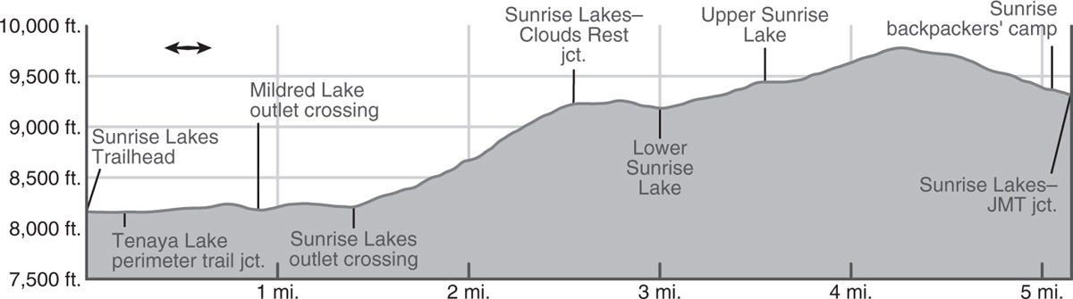
DAY 1 (Sunrise Lakes Trailhead to Sunrise Creek, 9.7 miles): From the trailhead parking area, follow the eastbound trail. After a few steps you pass a small spur trail that departs to the right (south) toward May Lake and Olmsted Point, then cross the usually flowing outlet of Tenaya Lake on large rock blocks (an early-season wade). Just beyond this crossing you reach a trail junction, where left (northeast) leads to Tenaya Lake’s southeastern shore, while you go right (south-southwest) toward Sunrise High Sierra Camp. Three hundred feet later is a second junction, where left (north) also leads to Tenaya Lake’s southeastern shore, while you go right (south). The trail briefly parallels Tenaya Creek before veering a little left, gently crossing a minor rise and dropping to a ford of Mildred Lake’s outlet. Beyond, you continue an undulating traverse south in sparse forest. You pass pocket meadows and cross several seasonal tributaries, the Sunrise Lakes outlets, before embarking on a notably steep collection of switchbacks—few Sierra trails ascend 1,000 feet in just 1.1 miles. The trail is also, in places, annoyingly rocky, reflecting the many half-buried boulders and partially submerged slabs with which the trail construction crew had to contend. At least these switchbacks are, for the most part, mercifully shaded, and where they become steepest, they give back with the beauty of astounding views of the surrounding granite landscape as well as a fine wildflower display underfoot. Soon after the hemlock-and-red-fir forest becomes denser, the switchbacks end, and the trail levels out as it arrives at a junction on a shallow, forested saddle, 2.5 miles from the trailhead. This junction was once known as Forsyth Pass, although the name has long since vanished from maps. Right (south) is your route to Clouds Rest, while left (east) leads to the Sunrise Lakes and Sunrise High Sierra Camp (Trip 43).
Continuing straight ahead on the Forsyth Trail, you begin a generally southward, 320-foot, switchbacking descent. At the bottom of the descent, the trail rises over a talus-swollen little ridge and drops beside a pleasant-looking lakelet (small campsites nearby). Continuing south, the trail ascends a lightly forested hillside, crosses an unnamed stream (with small campsites nearby), or in times of high runoff a trio of creeklets. This slope is boggy until midsummer, and the plentiful groundwater nourishes rank gardens of wildflowers throughout the summer. You have the choice to camp in this vicinity or just over 5 miles farther along where you next encounter flat ground and water together.
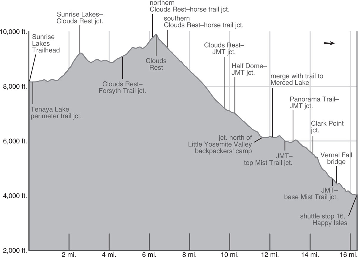
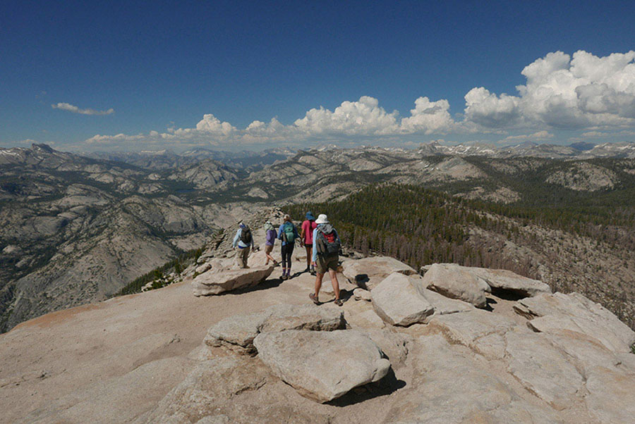
Looking northeast from Clouds Rest’s summit to Tenaya Lake and endless granite domes and peaks Photo by Elizabeth Wenk
A 200-foot ascent beyond the streams leads to a junction, where the Forsyth Trail turns left (south), descending a slope decimated by the 2014 Meadow Fire, while you stay right (west) toward Clouds Rest. Trending west, then northwest, you attain a gravelly crest. Onward, you traipse southwest for about a mile, crossing a minor saddle and soon ogling the dramatic granite slabs defining Tenaya Canyon to your north. Ascending more steeply, you reach a junction with a horse trail that bypasses Clouds Rest’s actual summit.
ALTERNATE ROUTES UP CLOUDS REST
If you struggle with exposure, at the Clouds Rest–horse trail junction you may wish to consider one of three alternatives. You could bypass the summit, simply trending left (south) on the horse trail, cutting 0.2 mile from the hiking distance, but will miss the view from the summit. You could leave your overnight pack at this junction (securing your food in your bear canister first), and hike to the summit without the cumbersome weight on your back, then return to this junction and take the horse trail bypass, adding a little under 0.2 mile to your distance. Or third, you could for now follow the horse trail 0.55 mile to a second junction where you meet the main Clouds Rest Trail ascending from Yosemite Valley. Here you would leave your pack and turn right (north) to follow this trail 0.6 mile to summit Clouds Rest via its less-exposed western side. This adds nearly a mile to your day, but without your pack. The junction west of the Clouds Rest summit is where all hikers reunite to follow a common route.
The trail essentially dies out beyond the horse trail junction, and the route to the summit of Clouds Rest follows a bedrock rib southwest. You scramble a few feet up to the narrow crest that leads to the summit; although there are drop-offs to either side, following the center of the rib limits your exposure, ensuring you can’t fall far. Focus on your footing until you reach the broader summit, then sit and enjoy the view. The panorama from Clouds Rest is among the most spectacular in the Sierra, including a 4,500-foot continuous granite slope stretching all the way down to Tenaya Creek and rising on the other side—the largest exposed granite area in Yosemite. The views are equally stunning in all directions: west to Half Dome and Yosemite Valley, south to the Clark Range, or east to the Sierra Crest.
Continuing on to Yosemite Valley, you negotiate short switchbacks down through a dense growth of chinquapin bushes. Beyond the rocky summit, descend longer switchbacks past western white pines and scattered Jeffrey pines to a junction with the western terminus of the aforementioned horse trail. Staying right (west), the trail descends past the back sides of the two Clouds Rest “pinnacles,” both broken with an abundance of horizontal fractures. The trail traverses in front of the pinnacles on a sandy tread decorated with shaggy-barked western junipers and nearly touches the rim of Tenaya Canyon, before initiating a steep switchbacking descent down an open slope. Reentering forest cover, your previously plentiful views of towering Half Dome instantly vanish, and you pass a trickling spring (good drinking water). Your moderate-to-steep descent soon leaves the last red firs behind, and, through a forest of white fir and Jeffrey pine, you drop eventually to a junction with the John Muir Trail (JMT). Here, close to a tributary of Sunrise Creek, you’ll find many campsites (7,159'; 37.74396°N, 119.50374°W).
MORAINE DOME
François Matthes, in an interesting “detective story” written in the form of a geological essay, discusses Moraine Dome extensively. He deduced, using three examples, that the moraines around the dome were the product of at least two glacial ages—a notion contrary to the thinking of the time. The morainal till of the last glacial age comprises the underfooting of the descent into Little Yosemite Valley.
DAY 2 (Sunrise Creek to Happy Isles Trailhead in Yosemite Valley, 6.6 miles): You continue descending along the JMT, reaching a junction with the Half Dome Trail after 0.55 mile. If—and only if—you procured a Half Dome permit when you applied for your Wilderness Permit, you may choose to take the approximately 4-mile round-trip detour to the summit of Half Dome from this point.
HALF DOME
If you obtained a permit to summit Half Dome—requested with your wilderness permit—turn right (north). After a 0.6-mile ascent through unassuming forest, the trail bends west and soon reaches a saddle offering filtered views north across Tenaya Canyon. Half Dome’s northeast face comes into view just before the trail tops a crest, and beyond you also have views backward to Clouds Rest and its satellites, the Quarter Domes. After a few more switch-backs you achieve a broad ridge, and traverse west. This flat, relaxing interruption in the climb ends all too soon at the base of Half Dome’s abruptly ascending shoulder. Beyond here a permit is required for all people, and rangers indeed patrol throughout the day. This is also where you must stop—for your safety—if thunderstorms threaten or the rock is wet. Nearly every fatality on Half Dome’s cables has occurred when the rock is wet! Almost two dozen very short switchbacks guide you up the view-blessed ridge of the dome’s shoulder.
Topping the shoulder, you are confronted with the dome’s intimidating pair of cables, which definitely cause some hikers to retreat. If you stare up the cables and decide this is not for you, feel comfortable in your decision and spend a delightful hour basking in the sun on the shoulder, watching the antlike line of people work their way up and down the cables and decide, quite accurately, that you have already reached an excellent viewpoint.
The ascent starts out gently enough, but it too quickly steepens almost to a 45-degree angle. On this stretch, first timers often slow to a snail’s pace, clenching both cables with sweaty hands—hands hopefully ensconced in gloves with a good grip. Most people are surprised by how much they use their arms on the ascent, especially for the middle third of the climb. Most frightening to me is the continual jockeying of people trying to pass or overtake each other, necessitating holding on to just one of the cables. Passing opposing traffic is best done courteously and where boards are laid between the cables in front of periodic posts.
Eventually an easing gradient provides new incentive, and soon you are scrambling up to the broad summit of Half Dome, an area about the size of 17 football fields. From the broad summit of this monolith, you have a 360-degree panorama. You can look down Yosemite Valley to the bald brow of El Capitan and back up Tenaya Canyon past Clouds Rest to Cathedral Peak, the Sierra Crest, and Mount Hoffmann. Mount Starr King—a dome that rises only 250 feet above you—dominates the Illilouette Creek basin to the south, while the Clark Range cuts the sky to the southeast. Looking due east across Moraine Dome’s summit, you see Mount Florence, whose broad triangular form hides the park’s highest peak, Mount Lyell, behind it. In this direction you will also see the forest charred in the 2014 Meadow Fire.
Meanwhile, the JMT turns left (south) and continues switchbacking down through a changing forest cover—incense cedar and sugar pines become more common along this stretch, providing dense shade, while the higher elevation conifers vanish. A final collection of tight zigzags drops you into the northwestern corner of Little Yosemite Valley, where you turn right (west). The left (south) branch would take you to the large Little Yosemite Valley backpackers’ camp, with toilet and bear boxes. If you’ve climbed Half Dome, you may have chosen to take an extra day for your trip and could spend the night here, the last legal camping before Yosemite Valley. A summer ranger is often stationed at a nearby cabin.
The fork you’ve taken angles across Little Yosemite Valley and after about 0.5 mile converges with the trail to Merced Lake along the quiet banks of the Merced River. At this junction, you turn right (west), shortly ascend out of Little Yosemite Valley, then descend a dry rocky slope to a junction, with pit toilets, where the JMT meets the famous Mist Trail at the top of a gully. Both descend toward Yosemite Valley, but this trip stays on the JMT by going left (south, then southwest) from this junction, and climbing briefly to reach the banks of the Merced River at the top of Nevada Fall. Along the river, slabs and pools beckon, but stay out of the rushing water, for people have been swept over 594-foot Nevada Fall. A cryptic lookout on the river’s north side offers close-ups of the fall: when you are still about 100 feet north of the bridge, walk toward the rim and you’ll find some roughly built steps that lead to a hidden shelf, from which you turn left to reach a railing.
MIST TRAIL
The Mist Trail drops very steeply on tight, slippery switchbacks to the foot of Nevada Fall, flattens out briefly, descends another bit, crosses the Merced River on a footbridge, passes a junction with the lower end of a connector descending from Clark Point, passes the Emerald Pool, and crosses slab to a vista at the brink of Vernal Fall. The trail then descends down a gully south of Vernal Fall. Partway down the trail sidles closer to the river and is usually soaked by spray from Vernal Fall—as are the hikers descending the tall, wet, slippery steps. After the Mist Trail levels out below Vernal Fall, it rejoins the JMT. We don’t recommend the Mist Trail for backpackers until water levels drop in late July, but it’s a day hikers’ challenge and delight.
Continuing the journey, the JMT crosses the Merced River on a footbridge, climbs briefly beneath conifer cover, and presently meets a couple of junctions with the Panorama Trail, which started at Glacier Point and ends here. At both junctions, trend right (west) on the JMT to begin a high traverse along a trail blasted into the rock. A stout rock wall protects you from the possibility of a slide, so you can instead imbibe the ever-changing panorama of domelike Liberty Cap and broad-topped Mount Broderick—both once overridden by glaciers. As you progress west, Half Dome becomes prominent. All the while, Nevada Fall decorates the foreground, its water dancing and churning down through the air. Eventually you descend to Clark Point, where the JMT continues left (west), making a long descent down a gully on quite shaded, cobbled switchbacks. It levels out, meets a signed HORSE TRAIL coming in from the left (west), and presently reaches a junction where the Mist Trail rejoins from the right (east). Turning left (west), the JMT follows the Merced River downstream, curving north to cross the river on a footbridge that offers a superb view of 317-foot Vernal Fall. On the south side of the river, before you cross the bridge, there are restrooms on the left and a drinking fountain on the right.
Once across the bridge, the trail climbs a few steps before beginning a long, reasonably steep descent down a mostly paved trail. Just where the trail makes a prominent bend to the right, looking south, you may glimpse Illilouette Fall high in Illilouette Gorge. Looking west yields views of the steep wall beneath Glacier Point, the scar from a massive rockslide in July 1996 still obvious. The deposit of boulders lies close to the cliff wall, and beyond is a ring of trees, toppled by the air blast that accompanied the slide. Looking north you just catch a glimpse of Yosemite Falls. Continuing down past a small spring, the JMT presently passes above the Happy Isles (named for two rocky islets in the Merced), then a gauging station and the remains of a bridge to the Happy Isles, washed out in 1997 floods. Beyond, the now broad trail intersects the Happy Isles Loop Road, and you turn left and cross a bridge to reach the shuttle stop (4,025'; 37.73242°N, 119.55965°W).
From here, you can walk or take the Valley Shuttle bus to your car (see shuttle directions), the backpackers’ campground (at the back of North Pine Campground, across a bridge near site 335) where you’re allowed to spend a night, or Yosemite Village where you may be meeting the YARTS bus back to Tenaya Lake.