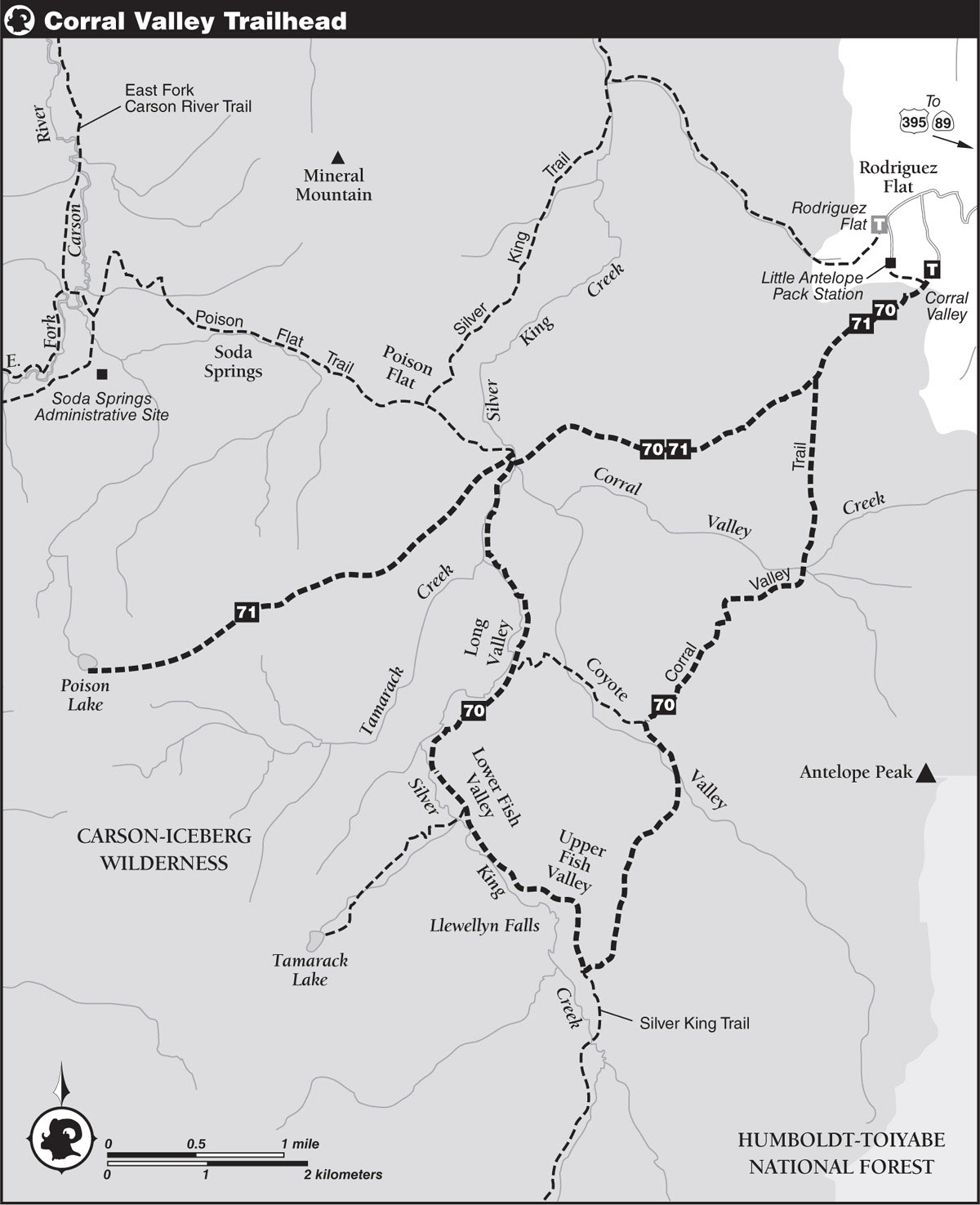
INFORMATION AND PERMITS: Responsibility for Carson-Iceberg Wilderness is split between Stanislaus and Humboldt-Toiyabe National Forests. For trips from the Corral Valley Trailhead out of Rodriguez Flat, get information from Humboldt-Toiyabe National Forest’s (HTNF’s) Carson Ranger District: 1536 S. Carson St., Carson City, NV 89701; 775-882-7766, fs.usda.gov/htnf. Wilderness permits are required, but there are no quotas, and permits can be self-issued at the information bulletin boards near the trailhead or procured at HTNF ranger stations. Note that for trail information, the USDA/USFS Carson-Iceberg Wilderness Map is generally more accurate than the topos.
DRIVING DIRECTIONS: From the junction of US 395 and CA 89, travel 5.5 miles south on US 395 to Coleville and continue another 2.2 miles to Mill Canyon Road heading west, signed MILL CANYON ROAD (for northbound motorists, this junction is 15.5 miles north of the US 395/CA 108 junction, about 2.5 miles north of Walker). Follow the road west and, following signs for Little Antelope Pack Station, proceed up the dirt road 0.3 mile to a fork and veer right. Continue another 5.7 miles to a mountain-crest road junction at broad, open Rodriguez Flat. Turn left (south), following signed directions for the Corral Valley Trailhead, and drive a narrow, rocky 0.4 mile to the end and the signed trailhead.
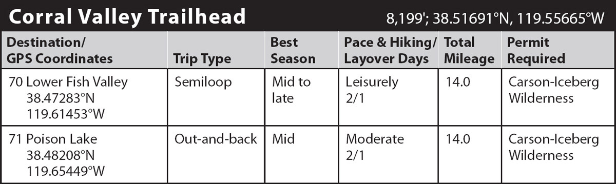
trip 70 Lower Fish Valley

Trip Data: |
38.47283°N, 119.61453°W; 14.0 miles; 2/1 days |
Topos: |
Coleville, Lost Cannon Peak |
HIGHLIGHTS: A fine weekend selection, this two-day trip visits five subalpine valleys. The country contains some of the largest Sierra junipers to be found anywhere. In addition, more than a half dozen side trips can be made from the Silver Creek Trail.
HEADS UP! The 2020 Slink Fire is burning near the Corral Valley Trailhead as this book goes to press and will likely impact the initial stretch of trail.
DAY 1 (Corral Valley Trailhead to Lower Fish Valley, 7.5 miles): On the Corral Valley Trail, make a moderate climb southwest, shortly reaching a trail on the right from the Little Antelope Pack Station and almost immediately entering signed Carson-Iceberg Wilderness. Continue ahead (southwest) through a cover of white firs, western white pines, and lodgepole pines on a stiff, 0.3-mile climb. Break out of the trees into an extensive area of sagebrush scrub, where the old, metamorphosed sediments of Rodriguez Flat give way to much younger volcanic rocks. The view here is quite spectacular on clear days, with desert ranges visible in the northeast well beyond Rodriguez Flat.
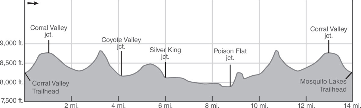
The short, open ascent soon arcs around the base of a volcanic hill to provide new views of Slinkard Valley in the north and the Sierra Crest in the northwest. A traverse south-southwest across broad, gentle, sagebrush-covered slopes leads to a signed junction, where the trail to Long Valley forks right (southwest; tomorrow’s return route).
Veer left (south) at the junction, remaining on the Corral Valley Trail, and descend moderately through sagebrush and bitterbrush to the well-used grazing lands of Corral Valley Creek. On the valley floor, the trail crosses two branches of Corral Valley Creek. Paiute trout, an endangered and protected species, live in Corral Valley Creek, as well as in Silver King Creek and Coyote Valley Creek, so there’s no fishing!
Beyond Corral Valley Creek, the southbound trail heads into the forest, curves west, parallels the valley for a short distance, and then climbs an ever-increasing slope to a dry saddle. From here, the descent into Coyote Valley is steep, made slightly easier by the cushioning effect of the deep gravel. Near the bottom of a gully, the trail crosses a seasonal creek and continues a short distance southwest before encountering an enormous, twin-trunked juniper. Beyond, the trail winds south down toward Coyote Valley, reaching the sagebrush-covered floor beside a large, 5-foot-diameter lodgepole pine (a key landmark for northbound hikers).
Hike a level quarter mile across the valley floor to an easy ford of Coyote Valley Creek. Beyond the ford, the trail veers away from the creek and gradually climbs south. Near the crest above Upper Fish Valley, the forest becomes denser and dominated by aspens. Pass through a fence gate at the crest’s broad saddle and descend steeply to Upper Fish Valley. On the floor of the valley, near an orange snow-depth marker, reach a signed junction with a lateral left (southwest) to Whitecliff Lake. Go right (north) about 300 yards past the junction to a meeting of three fences, each with a gate. Go through the north gate and follow the path that parallels the west side of the north-northeast–trending fence. The trail soon curves northwest, climbs over a low moraine, and then comes to within earshot of unseen Llewellyn Falls, just a short distance southwest. A short walk leads to the significant 20-foot cascade of Llewellyn Falls.
WHAT’S FISHY ABOUT LLEWELLYN FALLS
Biologists speculate that as a giant glacier slowly retreated up Silver King Canyon, perhaps 50,000 years ago, cutthroat trout followed its path. The fish were able to swim into Upper Fish Valley and beyond before Silver King Creek eroded away bedrock to form Llewellyn Falls. Once isolated, the trout evolved into a subspecies known as Paiute cutthroat trout (Salmo clarki seleniris), or simply Paiute trout. Ironically, these fish became endangered not because of overfishing but rather through the introduction of Lahontan cutthroats and rainbows, which bred with the Paiutes to produce hybrids. Once this miscegenation was discovered, Department of Fish and Game workers removed the purebreds and, in 1964, treated Silver King Creek with rotenone to kill the hybrids. After the purebreds were reintroduced to the stream above the falls, their numbers grew from approximately 150 in the late 1960s to about 600 in the early 1970s. By 1975, the population stabilized, but fishing is strictly prohibited, as the Paiute could easily be fished out of existence.
From Llewellyn Falls gorge, the trail descends briefly northeast into Lower Fish Valley. The trail approaches Silver King Creek several times before crossing the stream at the north end of this grassland. Although tree-shaded campsites are nearby (7,937'; 38.47283°N, 119.61453°W), they may be less than desirable if people and cattle have left too much of a mess. Fishing along Silver King Creek below Llewellyn Falls may yield rainbow, Paiute, or rainbow–Paiute hybrids. But beware: Taking Paiute purebreds is prohibited.

The Sierra Crest is the backdrop for this equestrian on the Corral Valley Trail. Photo by Mike White
DAY 2 (Lower Fish Valley to Corral Valley Trailhead, 6.5 miles): Continuing downstream, walk northwest toward a low ridge that hides the forested, little-visited valley of Tamarack Creek. The path leaves Lower Fish Valley, turns northeast, and climbs over a low granitic saddle before entering the south end of Long Valley. To avoid springs and boggy meadows, follow the trail that circles around the east side of the valley. Partway down the flat valley, the trails rejoin and then approach Silver King Creek, which meanders lazily through the glacial sediments that buried the canyon’s bedrock floor long ago. The trail approaches several of these meanders before exiting the valley at the north end.
Following Silver King Creek, the trail passes the confluence of Tamarack Creek and, after an easy half mile of shaded descent, leads to a ford of the stream where granite outcrops force the path to the west bank. Anticipate a wet ford in early season. About 200 yards downstream is a junction with multiple trails: your route goes right (northeast) across the creek; to the left (north), the trail you’ve been on for a while climbs a sandy slope to meet the trail to Poison Lake.
Heading right, now on the Long Valley Trail, make another wet ford of the creek (last water late in the season) and begin ascending a largely unshaded slope above the creek on long, gentle-to-moderate switchbacks through chaparral. When the switchbacks end, the dusty trail bears generally east and then northeast across the sunstruck hillside on a gentle, occasionally moderate, grade. As you approach the next junction, you’ll see an unusual monument, an arri mutillak, on your left.
ARRI MUTILLAK
An arri mutillak is a large stone cairn—this one is said to be 7 feet high—built to pass the time by lonely Basque sheepherders who once tended flocks in this area. You can make your way through the chaparral to take a closer look, but don’t alter the arri mutillak, which means “stone boy” in Basque.
Shortly beyond the arri mutillak, you reach the junction with the Corral Valley Trail, onto which you turned on Day 1. Here, 2.5 hot, dusty miles from your last crossing of Silver King Creek, you close the loop and turn left (north-northeast) to retrace your steps.
trip 71 Poison Lake
Trip Data: |
38.48208°N, 119.65449°W; 14.0 miles, 2 days |
Topos: |
Coleville, Lost Cannon Peak, Disaster Peak |
HIGHLIGHTS: Solitude usually abounds on this overnight trip into a beautiful lake in the Carson-Iceberg Wilderness, where good swimming and fishing await. Despite the name, Poison Lake is not poisonous at all. Along the way, you’ll experience sweeping views of canyons and mountains.
HEADS UP! The 2020 Slink Fire is burning near the Corral Valley Trailhead as this book goes to press and will likely impact the initial stretch of trail.
DAY 1 (Corral Valley Trailhead to Poison Lake, 7.0 miles): On the Corral Valley Trail, make a moderate climb southwest, shortly reaching a trail on the right from the Little Antelope Pack Station immediately prior to the signed Carson-Iceberg Wilderness boundary. Continue ahead (southwest) through a forest cover of white firs, western white pines, and lodgepole pines on a stiff, 0.3-mile climb. Break out of the trees into an extensive area of sagebrush scrub, where the old, metamorphosed sediments of Rodriguez Flat give way to much younger volcanic rocks. The view here is quite spectacular on clear days, with desert ranges visible in the northeast well beyond Rodriguez Flat.
The short, open ascent soon arcs around the base of a volcanic hill to provide new views of Slinkard Valley in the north and the peaks along the Sierra Crest in the northwest. A traverse south-southwest across broad, gentle sagebrush scrub–covered slopes leads to a marked junction, where the Corral Valley Trail veers left (south) and your route forks to the right.
Gently graded tread leads away from the junction through acres of sagebrush scrub, sprinkled with wildflowers in early season, including mule ears, phlox, lupine, common dandelion, and others. Fine views of the Sierra Crest are your constant companion along the protracted descent. Eventually the trail descends more steeply toward Silver King Creek, culminating in a series of switchbacks amid widely scattered junipers on the way to a ford. While the water is not deep here, it’s deep enough for the use of an extra pair of water shoes or bare feet for the crossing. Once on the far bank, turn right (north) onto the Silver King Creek Trail (21017) for about 100 yards to a junction with the trail to Poison Lake.
Turn left (southwest) and climb steeply for a while before the grade eases on the way to the top of a ridgecrest, and then follow the trail along the top of the ridge for the next mile. At the end of the ridge, near the base of a steep slope, climb stiffly southwest to a minor ridge, which provides a sweeping view of the ragged Sierra Crest to the southwest. From the ridge, the trail continues to ascend through thick brush. Soon, short, very steep switchbacks lead up into forest shade once more, as the grade becomes more pleasant.
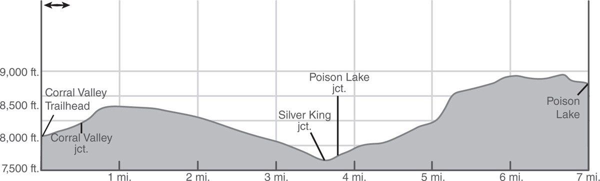
More climbing leads to a small, rocky flat densely covered with sagebrush and bitterbrush. At the south end of the flat is a good view up the canyon into Lower Fish Valley, Upper Fish Valley, and Fourmile Canyon. Beyond the flat, the path makes an undulating traverse west toward a small canyon, passing just above its head. From there, the trail turns briefly northwest and then resumes the southwest journey, passing several meadows before leveling off on a broad ridge above Poison Lake. A short, steep descent down this ridge leads to the lake’s willow-lined south shore (9,152'; 38.48208°N, 119.65449°W). Good lodgepole-pine-and-hemlock-shaded campsites may be found on the northwest shore. Fishing can be good for brook trout.
DAY 2 (Poison Lake to Corral Valley Trailhead, 7.0 miles): Retrace your steps.
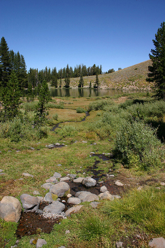
A spring near Poison Lake Photo by Mike White