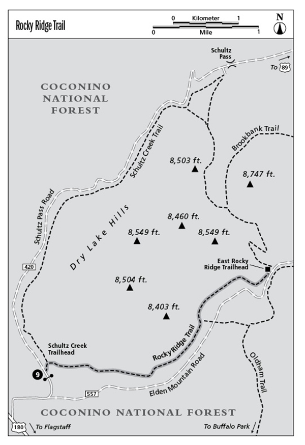
9 Rocky Ridge Trail
This is an easy hike along the base of the Dry Lake Hills. The trail faces south and dries out earlier in the spring than the other trails in the Dry Lake Hills–Elden Mountain trail system. Access is quick from Flagstaff. This is a good hike when you do not have much time.
Location: 4 miles northwest of Flagstaff.
Distance: 5.4 miles out and back.
Approximate hiking time: 3 hours.
Elevation change: 440 feet.
Best seasons: Late spring through fall.
Water: None.
Other trail users: Horses and mountain bikes.
Canine compatibility: Dogs are allowed if kept under control.
Permits and restrictions: None.
Maps: USGS Flagstaff West, Humphreys Peak, and Sunset Crater West; Coconino National Forest. The trail is not shown on the topographic map.
Trail contacts: Peaks Ranger District, Coconino National Forest, 5075 N. Highway 89, Flagstaff, AZ 86004, (928) 526-0866, www.fs.fed.us/r3/coconino/.
Finding the trailhead: From Flagstaff, drive northwest about 3 miles on U.S. Highway 180, then turn right (north) on the Schultz Pass Road (Forest Road 420). Continue 0.8 mile to the end of the pavement and park near the gate at the Schultz Creek Trailhead. The gate may be closed during winter and early spring when Schultz Pass Road is muddy.
The Hike
Walk through the gate, then down an unmaintained dirt road to the right (northeast) for about 0.1 mile to the signed trailhead. Go right (east) on the Rocky Ridge Trail and follow it up a gentle slope. The trail stays below the steep south slope of the Dry Lake Hills. It climbs gradually through open ponderosa pine and oak forest, and eventually turns more to the north as it enters the canyon between the Dry Lake Hills and Elden Mountain. At 1.2 miles, watch for a metal bearing-tree poster on a pine next to the trail. Forest Service surveyors use bearing-trees, which are marked with small (about 4 inches square) metal posters, to give the direction and distance to a nearby survey marker. One or more bearing-trees serve as backups in the event the primary marker is moved or lost.
The trail continues to contour along the slopes, gradually getting closer to the Elden Mountain Road (Forest Road 557). As the road first becomes visible below, a spur trail branches right (east), descends to Elden Mountain Road, then connects to the Oldham Trail. Remain on the Rocky Ridge Trail, which stays above the road and swings east, then north as the canyon narrows, before ending at the road at 2.7 miles. To return to the trailhead, retrace your steps.
(Options: You could continue the hike by heading off onto any of three other trails that leave from the East Rocky Ridge trailhead. See the Brookbank (Hike 8), Sunset-Brookbank Loop (Hike 10), and Oldham (Hike 12) trail descriptions for more details.)

Miles and Directions
0.0Schultz Creek Trailhead.
1.2Pass the bearing-tree.
2.7Arrive at the East Rocky Ridge Trailhead.
5.4Arrive back at the Schultz Creek Trailhead.