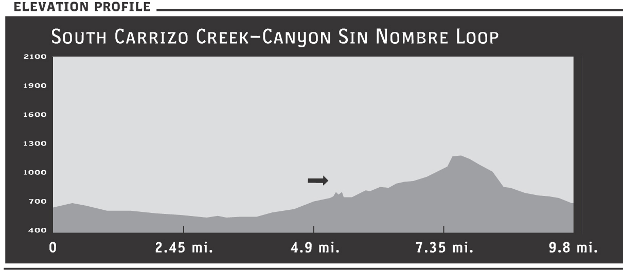
31 South Carrizo Creek–Canyon Sin Nombre Loop
SCENERY: 
DIFFICULTY: 
TRAIL CONDITION: 
SOLITUDE: 
CHILDREN: 
DISTANCE: 9.8 miles round trip
HIKING TIME: 5 hours
OUTSTANDING FEATURES: Sandy wash, open desert, smoke trees, and birds
One of my favorite loops, this hike allows you the feel of forging your own path—without having to work too hard at it. The final leg of this trek is on open desert closed to vehicles and not often visited by those on foot. Be alert for surprises. The wild desert never disappoints.
Directions: From Interstate 8E, take the Ocotillo Imperial Highway exit and head northwest on County Route S2 (the Great Overland Route of 1849). Drive 12.8 miles, just past the Canyon Sin Nombre turnout, to the sign marker for South Carrizo Creek, also on the right. As an alternative, where CA 78 meets CR S2, head south on CR S2 for approximately 32 miles. En route, you’ll see the sign marking your entrance into Anza-Borrego Desert State Park at about 4.4 miles. After 21 miles, CR S2 veers left (a side road goes straight here, so pay attention). The Carrizo Creek turnoff is on the left. Park just off the Jeep road (so others can pass), near S2.
| GPS Coordinates | 31 SOUTH CARRIZO CREEK–CANYON SIN NOMBRE LOOP | |
| UTM Zone (WGS84) | 11S | |
| Easting | 574945 | |
| Northing | 3634464 | |
| Latitude–Longitude | N 32º 50’ 44.4583” | |
| W 116º 11’ 56.8682” |


 From the parking area (see Directions following), head northeast on the dirt road. The wide-open space is relaxing. Enjoy the vast expanse of the desert beneath a wide sky and framed by rippled mountains in the distance.
After approximately 0.5 miles of easy walking on flat terrain, continue northeast past the strip of pines. The road continues northeast, with creosote bushes becoming the prominent feature (small leaves, yellow blooms, fuzz ball–type fruits). You’ll also see some remnants of barbed-wire fencing from Anza-Borrego’s cattle days and pass by some turnout spots on the right—probably holding campers on weekends during the busy spring desert-recreation season.
At 3.5 miles, the dirt road comes to a T. Go to the right (east). Vehicle use isn’t allowed in this section, so the sandy wash not packed by moving tires becomes looser, making for more difficult walking. After approximately 0.2 miles, the lay of the wash crimps sharply left (southwest). Look due south and notice the V of Canyon Sin Nombre ahead. Move away from the main wash, taking a more southerly route to the canyon opening.
Walk south-southwest through Canyon Sin Nombre and follow the vehicle path up to County Route S2 (for details, see Canyon Sin Nombre write-up). When you reach the highway, you’ll have gone 7.4 miles. At S2, turn right and walk on the shoulder, downhill, heading west. After approximately 0.7 miles, you’ll approach a hairpin turn of S2. Cross the highway here (careful of any traffic!), and access a trail heading steeply southwest down the ravine (with S2 now on your right). At the bottom, go right, following the northwest bend of the highway. Keep S2 in sight, but there’s no need to get too close to the road. Keeping your distance allows you to savor the desolate feel of the open desert.
It’s approximately 2 flat miles of sandy wash–type landscape until you spot your vehicle parked on the opposite side of S2. Take your time, enjoying this last, flat leg of the hike. This little-walked area is bound to draw a few stares from passers on the highway. Cars slowing, their inhabitants curious as to what you’re doing off the road, is part of the fun. Nature may have a surprise or two as well. On my last visit, I first heard the calls of the loggerhead shrike. A few minutes later, what I saw while pausing near a smoke tree confirmed the birdcall really was that of a loggerhead shrike. Impaled on the thorn of a smoke tree hung the proof—a decapitated lizard. Nicknamed the butcherbird for its habit of hanging its prey from barbed wire or thorns, the loggerhead shrike doesn’t have the strong talons of other predator birds. Therefore, it uses this impaling technique to compensate, allowing it to shred the kill into bite-sized pieces.