2.1. Stratigraphic units of the North Unit of Badlands National Park. The sequence in the west includes the rocks of the Red River paleovalley of Clark, Beerbower, and Kietzke (1967) and the rocks exposed on Sheep Mountain Table. The sequence in the east is a composite of features from the Dillon Pass area east to Norbeck Ridge.
THE ROCKS OF BADLANDS NATIONAL PARK RECORD THE end of the great Western Interior Seaway near the end of the age of dinosaurs (Mesozoic Era) and, after a 30-million-year gap, record some of the features on land during the greatest volcanic eruptive intervals and one of the greatest climatic changes in the age of mammals (Cenozoic Era). To understand the geologic history of the sedimentary rocks exposed in the South Dakota Badlands, we need to see how the rocks are distributed in space and time (stratigraphy) and how they were deposited (sedimentology). We start our story by building the framework of the rocks in space and time by discussing the stratigraphy of the Badlands. The rocks in the Badlands were deposited in the sea, in river deltas, by rivers, in lakes, and by the winds, and we will discuss the evidence for these depositional environments. To understand the ancient environments and how they changed through time, we need to start by understanding the origins of the sediments that now make up the 190 m thick sequence of rocks exposed in Badlands National Park (Fig. 2.1).
Sedimentary geologists recognize formal stratigraphic units, or distinct packages of rocks that are carefully described and named for permanent geographic features and their associated lithologies. These formal stratigraphic units include formations, members, and groups. The fundamental stratigraphic unit is a formation, which is a package of sedimentary rock with unique lithologic (rock) features that separate it from other formations above and below it. Formations must be widespread and thick enough to be easily plotted on a map. There are six formations recognized in the Badlands, including, from the oldest to the youngest, the Pierre Shale, the Fox Hills Formation, the Chamberlain Pass Formation, the Chadron Formation, the Brule Formation, and the Sharps Formation. Formations of similar origins and closely related through time can be combined to create groups. The Chamberlain Pass, Chadron, and Brule formations are part of the White River Group, the subject of most of this discussion. The 365 m thick Pierre Shale that lies below the Fox Hills Formation has traditionally been considered to be a formation, but Martin and Parris (2007) have subdivided the Pierre Shale into seven formations and elevated the unit to the Pierre Shale Group. (We will continue to call this unit simply the Pierre Shale in the following discussion.) Formations can be subdivided into members, which are thinner, less distinctive, but widespread units within a formation. The history and nomenclature of the White River Group and its formal subdivisions is presented in Table 2.1. These names all refer to distinct packages of rocks that have unique features and contain fossils that record changes in environments through time. Our discussion will focus on the features of the White River Group, the rocks, and the main source of fossils in the intricately carved Badlands.
Sedimentary geologists also recognize a variety of informal stratigraphic units. These tend to be widespread distinctive individual layers, too thin to be named as members but nonetheless important markers for stratigraphic positioning. Such marker beds can include volcanic tuff beds, widespread limestone beds, and, in the case of the White River Group, thin but widespread mudstone layers that can be traced for many tens of kilometers through the Badlands. Volcanic tuffs, or just tuffs, are by far the most distinctive and stratigraphically significant marker beds. They are formed from the lithification of a volcanic ash, or a deposit of fine-grained volcanic material blown out of large volcanic eruptions, carried downwind as ash clouds, and deposited on the land surface, into lakes, or on the seafloor. Volcanic ashes fall within a day to a few months, which is essentially instantaneous in geologic timescales measured in millions of years. Tuffs are considered lithologic timelines, or layers that represent a single geologically brief event. The tuffs contain volcanic glass, an amorphous material similar to window glass formed from the quenching of tiny bubbles of lava during an eruption. Volcanic ash clouds also carry tiny crystals of minerals, such as zircon, biotite, hornblende, sphene, apatite, pyroxene, and the potassium feldspar sanidine, all found in tuffs in the White River Group in the Badlands. Each individual tuff contains a unique set of these minerals, and the minerals often have unique geochemistries that allow the tuffs to be identified from isolated outcrops scattered over broad areas (Larson and Evanoff, 1998). In the field, tuffs are fine-grained rock layers of mudstone or claystone with noticeable amounts of floating sand-size crystals with well-preserved crystal forms (called euhedral crystals). The most obvious of these is the six-sided crystals of biotite, a black mica that is so flat that large crystals of biotite are floated in air far beyond the other, more compact crystals. Volcanic ashes fall on to a land surface, so tuffs typically have sharp or distinct bottom contacts but gradually mix with background sediments to develop diffuse top contacts. Finally, many of the minerals in a tuff, especially zircon and sanidine, carry radioactive elements in their crystalline structure that can be dated by precise radioisotopic dating techniques.
Table 2.1. Origin of stratigraphic names used in the Big Badlands
Numeric geologic dates, typically given as millions of years ago (Ma), are determined by radiometric dating, which analyzes the ratios of original radioactive materials (the parent element) to concentrations of new materials (the daughter element) generated by the radioactive decay process (such as the conversion of the radioisotope potassium-40 to stable argon-40). Radiometric dating of White River rocks is best accomplished on volcanic tuffs that contain feldspar and zircon crystals that formed in the magma chamber just before the eruption. These crystals act as miniature time capsules and preserve the parent/daughter element ratios. Modern radiometric dating techniques can analyze single crystals, providing precise determinations of ages, often to within a few tens of thousands of years. So far no tuffs in the South Dakota Badlands have been radiometrically dated, but White River tuffs have been dated in Wyoming and Nebraska, thus providing numeric date calibration for the transitions of the land mammal ages (Fig. 2.2).
The fossil mammal assemblages of the White River Group changed over time and can be used to determine the relative ages of rocks in three biostratigraphic zones. The three fossil mammal assemblages include the lower mammal fauna characterized by the huge brontotheres (Megacerops). A second fauna lacks brontotheres but is dominated by the oreodont Merycoidodon and is associated with the rhino Metamynodon found in river-channel deposits. The highest and youngest fauna is dominated by the oreodont Leptauchenia with the odd-looking ungulate Protoceras in river channels. The early paleontologists working in the Badlands recognized this succession of fossil faunas as the Titanotherium bed, the turtle–Oreodon bed with the Metamynodon channels, and the Leptauchenia beds with the Protoceras channels (Hayden, 1858, 1869; Wortman, 1893). In 1941 Wood et al. formalized these faunal zones into the Chadronian, Orellan, and Whitneyan land mammal ages. The land mammal ages are essentially time zones defined by their unique fossil mammal assemblages (Woodburne, 2004; Fig. 2.2). The most recent work on land mammal ages in the White River Group has documented the detailed stratigraphic ranges of fossil taxa across the boundaries of these biostratigraphic units (Zanazzi, Kohn, and Terry, 2009; Mathis and MacFadden, 2010).
Another technique for determining the age of the White River rocks is the study of the ancient magnetic signals in the rocks, called paleomagnetic analysis. Tiny magnetic minerals, such as magnetite, will orient like bar magnets in saturated sediment to the Earth’s magnetic field at the time of deposition. As the sediments are lithified into sedimentary rocks, the orientation of the magnetic minerals is locked into the rock. What is curious about the Earth’s magnetic field is that the dynamics in the Earth’s liquid nickel–iron core will sometimes allow the north and south magnetic poles to switch, even though the Earth’s orientation and rotation remain the same. The modern orientation of magnetic poles is called normal magnetic polarity, and when the north magnetic pole switches to the south geographic pole, it is called reversed magnetic polarity. The tiny magnetic grains in sediments will orient either to the normal or reversed magnetic orientations, and these polarity zones will be preserved in the rocks. Because these polarity zones affect the entire globe, they can be used to correlate rocks or to match rocks of the same age around the world. The boundaries between polarity zones on the global magnetopolarity timescale have been calibrated with radiometric dates (Cande and Kent, 1992; Berggren et al., 1995; Luterbacher et al., 2004). The trick is to determine which polarity zone – normal or reverse – in a rock sequence belongs to which polarity zone on the global timescale. The magnetic signal in White River rocks is weak, but sensitive magnetometers can determine the polarity of oriented rock samples. Prothero (1985), Tedford et al. (1996), and Prothero and Whittlesey (1998) have analyzed the rocks of the White River Group in the Badlands and recorded four normal polarity zones and three reversed polarity zones. By matching these zones with the global magnetopolarity timescale (Fig. 2.2), Prothero estimated a duration of about 5 million years, from about 35 Ma to 30 Ma, for the deposition of the middle Chadron Formation through the end of the Brule Formation in the Badlands.
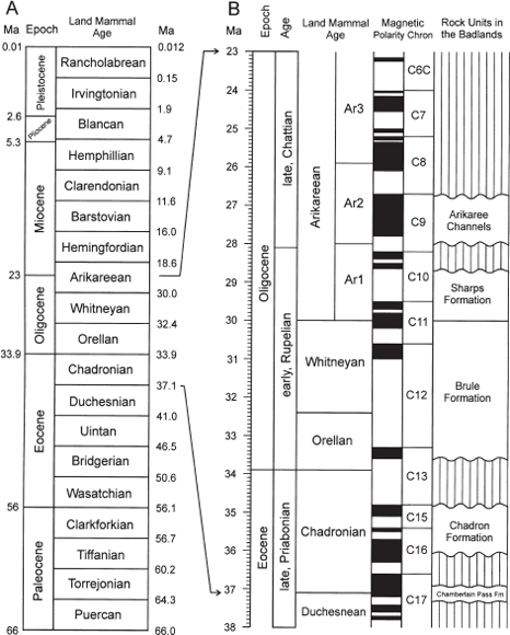
2.2. North American Land and Mammal Ages and the age relations of the rocks in the Big Badlands. (A) List of all the land mammal ages throughout the Cenozoic recognized in North America. The vertical scale does not reflect the actual duration of the individual land mammal ages. (B) Age chart of the ages and magnetostratigraphic features of 15 million years during the late Eocene through Oligocene. The vertical scale is in 100,000-year increments. Ar1 to Ar3 indicate subages of the Arikareean land mammal age. Estimated ages of the late Eocene and Oligocene rocks exposed in the Big Badlands are provided at right. The age dates for the epochs and ages are from the International Stratigraphic Chart for 2013 (http://www.stratigraphy.org/ICSchart/ChronostratChart2013-01.pdf). The numeric ages for the land mammal ages are from Woodburne and Swisher (1995), adjusted for current ages of the radiometric standard samples (Fish Canyon Tuff, 28.02 Ma). The ages of the Arikareean subages are from Albright et al. (2008). The ages of the paleomagnetic polarity zones is from Luterbacher et al. (2004) and Albright et al. (2008). Black intervals in the Magnetic Polarity column represent normal polarity intervals; white intervals represent reversed polarity intervals.
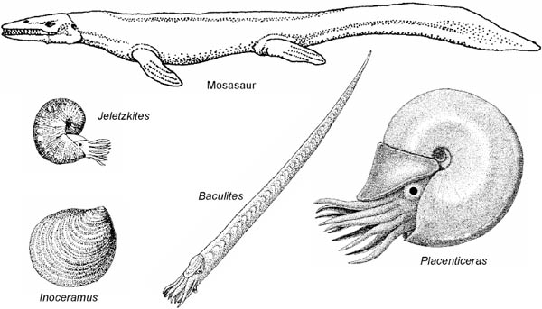
The oldest strata exposed in the Badlands is the Pierre Shale, an extremely thick sequence of black, organic-rich shale with scattered thin bentonites (volcanic ashes altered to clays at the bottom of the sea) and limestone nodules that often formed from groundwater precipitation of calcite around fossil marine shells. The fossils of the Pierre Shale include ammonites, large marine clams, and various types of marine reptiles, such as mosasaurs and giant sea turtles (Fig. 2.3). The fossils occur in zones that have been calibrated by radiometric dates to approximately 70 million years. The Pierre Shale represents the deposits of the shallow Western Interior Seaway, which covered the central part of North America and stretched from the Gulf of Mexico north to the Arctic Ocean, cutting North America into two separate landmasses. The Pierre Shale was named for exposures of this rock unit around Fort Pierre along the Missouri River by Meek and Hayden in 1862. The Pierre Shale is exposed in and around the Sage Creek Campground (Plate 1; see Fig. P.1 for the location of this site and other locations mentioned in the following discussion).
Overlying the Pierre Shale is the Fox Hills Formation. The Fox Hills Formation is a sequence of alternating gray to orange silty shale beds and brown to orange, fine-grained, thin to thick sandstone beds (Plate 1). Fossils are numerous in the Fox Hills Formation, including impressions of plant material, petrified wood, clams, fish scales, ammonites, crabs, shark teeth, and belemnites, a relative of the squid (Stoffer et al., 2001; Jannett and Terry, 2008). The mixture of terrestrial and marine fossils reflects the origin of the Fox Hills Formation as an advancing river delta into the Western Interior Seaway. There was continuous deposition between the Pierre Shale and the Fox Hills Formation with sandstone sheets increasing in number and thickness upward from the top of the Pierre Shale into the Fox Hills Formation. Throughout the entire package of strata that comprise the delta sequence, sediments will coarsen upward overall as areas that were once the toe of the delta were covered by additional sediment that built out into the ocean basin. The sand sheets show evidence of water flow as ripples from tide, storm, and river currents. Measurements of the alignment of these ripples show that this delta complex advanced from the north into the Badlands region. On the basis of the age of these fossils, the Fox Hills Formation in the Badlands persisted to about 67 Ma, just before the extinction of the dinosaurs. The Fox Hills Formation was named for outcrops in north-central South Dakota by Meek and Hayden (1862). It is best exposed in Badlands National Park at the upper Conata basin near Dillon Pass and below the Sage Creek Rim Road (Plate 1).
After the retreat of the Western Interior Seaway, the Badlands region experienced a prolonged episode that included both erosion and nondeposition, forming a surface that geologists call an unconformity, or contacts that represent major gaps in the geologic record. In the Badlands, this gap persisted for 30 million years. Both the older and younger rocks are essentially horizontal in the Badlands, but toward the Black Hills the Pierre Shale was tilted and eroded before the deposition of White River sediments. White River rocks filled valleys that cross older and older rocks to the west, eventually resting on Precambrian crystalline rocks in the center of the Black Hills (DeWitt et al., 1989). The tilting and uplift of the Black Hills was during an episode of mountain building across the eastern part of western North America, referred to as the Laramide Orogeny. The Laramide Orogeny was different from typical mountain-building events. Long mountain chains, such as the Cascades along the west coast of North America, are built by the plate tectonic process of subduction, during which dense oceanic crust slides beneath lighter continental crust and eventually dives down steeply into the mantle, melts, and provides magma to create volcanoes. The Laramide Orogeny was also caused by subduction of the east Pacific plate (called the Farallon Plate) during the latest Cretaceous and early Paleogene along what was the west coast of North America. However, instead of diving steeply into the mantle and melting, the Farallon Plate subducted at a low, shallow angle, like a spatula sliding under a pancake. This low angle of subduction did not produce volcanoes, but it compressed and shortened the overlying continental crust. This shortening forced large blocks of crust to pop up far to the east. These include the Rocky Mountains of south-central Montana, Wyoming, Colorado, and northern New Mexico, but further to the east, smaller blocks were also elevated by this compression to form localized mountains, such as the Black Hills. As the Black Hills pushed upward, their sedimentary rock cover was stripped to eventually expose the Precambrian core. The Black Hills rose during the Paleocene and early Eocene, as shown by sediments derived from Paleozoic and Precambrian rocks in the Black Hills that were shed to the northwest into the Powder River Basin of Wyoming (Curry, 1971; Flores and Ethridge, 1985).
During this extended period of time the Badlands region underwent an extensive episode of soil formation under humid and tropical conditions, similar to those in a modern-day rain forest. This altered the normally tan, beige, and brownish strata of the Fox Hills Formation and the underlying black Pierre Shale into a thick zone of bright yellow, red, and purple strata that can be seen at the base of the Badlands in Dillon Pass (Plate 2). This period of intense soil formation has been documented from North Dakota to Colorado and is generally referred to as the Interior Zone in the Badlands (Pettyjohn, 1966; Terry, 1998). At the base of the Interior Zone, Retallack (1983b) also a described a thick paleosol that he called the Yellow Mounds paleosol after the Yellow Mounds Overlook near Dillon Pass. This paleosol is more of a deep weathering zone in the Fox Hills Formation extending down from the red Interior Zone of stacked paleosols. Bedding features and original materials that would be removed within a soil are retained in the Fox Hills rocks that are in the Yellow Mounds weathering zone. An unusual gravel, composed almost entirely of quartz or other silica-rich rocks, was formed by the intense weathering that formed the Interior Zone soils. These gravels are scattered across the unconformity surface. It was not until the late Eocene (approximately 37 Ma; Fig. 2.2) that deposition resumed in the Badlands region. From this point forward, the sedimentary deposits that accumulated to create the various layers in the Badlands were totally terrestrial in origin, forming in rivers and lakes and as windblown accumulations of dust.
2.3. Reconstructions of some Cretaceous animals found in the vicinity of the Big Badlands. They include the 6 m long marine reptile mosasaur, the straight ammonite Baculites (shell length 1.2 m), and the coiled forms Placenticeras (80 cm shell diameter) and Jeletzkytes (9 cm shell height), which are related to modern squid and octopi. The clam shown is Inoceramus sagensis (maximum length 10 cm), named by F. B. Meek for Sage Creek. The figures are not to scale. Inoceramus was the most distinct and numerous bivalve of the Cretaceous Western Interior Seaway.
The Chamberlain Pass Formation is the basal unit of the White River Group and represents the return of deposition in this region 30 million years after the retreat of the Western Interior Seaway. The Chamberlain Pass Formation is recognized by its red mudstone and brilliant white lenticular bodies of sandstone directly overlying the bright yellow and red Interior Zone (Plate 2). The Chamberlain Pass Formation was deposited on the relatively flat surface of the unconformity. Although this unit is thin in the Badlands, it becomes progressively thicker, up to tens of meters, to the southwest in Nebraska. The age of the Chamberlain Pass Formation is constrained to the late middle Eocene on the basis of the rare occurrence of vertebrate fossils of the latest Duchesnean or earliest Chadronian land mammal age in South Dakota and Nebraska (Clark, Beerbower, and Kietzke, 1967; Terry, 1998). The formation is named for its type section at Chamberlain Pass, a gap in the Badland Wall near Kadoka, South Dakota (Evans and Terry, 1994; Fig. P.1). The Chamberlain Pass Formation is best seen in the Dillon Pass area, along the Sage Creek Rim Road and just west of the town of Interior along Highway 44 (Fig. P.1).
The Chadron Formation was named for the town of Chadron, Nebraska, by Darton (1899). Darton never named a type section for the Chadron Formation, but most workers consider the outcrops in northwest Nebraska to be the type area. Darton (1899) did recognize the formation’s presence in the South Dakota Badlands, replacing the old term, Titanotherium bed, with a lithologic unit. The mammalian fauna is a typical Chadronian fauna characterized in part by the presence of fossils of the huge brontotheres. The Chadron Formation is late Eocene in age, as based on a combination of vertebrate fossil data, paleomagnetic correlations, and radiometric dating of tuffs outside the South Dakota Badlands (Prothero and Emry, 2004).
The Chadron Formation in the Badlands is dominated by greenish-gray massive claystone beds and minor amounts of lenticular and sheet sandstones, conglomerates, and thin limestone sheets and stringers. The Chadron Formation includes the Ahearn, Crazy Johnson, and Peanut Peak members, all named by Clark (1954). The two older members are constrained to limited exposures west–southwest of Sheep Mountain Table. The Ahearn and Crazy Johnson members (Plate 3) filled a west-to-east paleovalley, called the Red River valley, which was cut 27.4 m below the surface of the Interior Zone (Clark, 1937; Clark, Beerbower, and Kietzke, 1967). The basal Ahearn Member rests directly on black Cretaceous Pierre Shale that was unaltered by the Interior Zone episode of soil formation. The Ahearn Member is composed of coarse basal gravel beds, multicolored sandstone beds, and upper tan to orange mudstones locally cut by lenticular sandstones (Clark, Beerbower, and Kietzke, 1967). The overlying Crazy Johnson Member includes a combination of numerous sandstone channels and sheets separated by olive mudstone and claystone beds (Clark, Beerbower, and Kietzke, 1967). The Peanut Peak Member is the most widespread unit seen throughout the Badlands. It directly overlies the Chamberlain Pass Formation and includes massive beds of olive-gray claystone that display haystack-mound morphology and a thick popcorn-textured weathered surface (Plate 4, bottom). Only the Peanut Peak Member of the Chadron Formation is recognized regionally (Terry, 1998). The three-part subdivision of the Chadron Formation is restricted to the Red River paleovalley and has limitations for regional stratigraphy (Harksen and Macdonald, 1969). For example, an unnamed fluvial sequence of channel sandstones, overbank sheet sands, and thin claystone sheets occur in the upper Chadron Formation in the vicinity of the town of Scenic and the Cain Creek drainage.
The Brule Formation directly overlies the Chadron Formation and is composed of alternating mudstone, muddy sandstone, and siltstone intervals with rare thick to thin limestone sheets. It is easily recognized as the brownish-tan, cliff-and-spire-supporting strata with prominent reddish-brown striping in its lower part and steep near-vertical cliffs in its upper part (Plate 4). The formation is divided into the lower Scenic Member and higher Poleslide Member (Fig. 2.1). The Scenic Member is composed of two thick intervals of massive, typically nodular mudstones separated by thick and widespread blankets of light gray well-bedded muddy sandstones. These sandstone blankets contain interbedded thin brown to red mudstone and claystone sheets exposed as the middle striped zone of the Badlands Wall. The overlying Poleslide Member is a more uniform tan to light gray and is composed mainly of thick siltstone and secondarily of rare mudstone beds and scattered, thick, well-bedded sandstone blankets. Sandstone blankets are widespread sequences of stacked sandstone sheets that can extend for 80 km along the Badlands Wall. Vertebrate fossils and paleomagnetic correlations (Prothero, 1996; Prothero and Emry, 2004) indicate that the Brule Formation is early Oligocene in age. The Brule Formation is capped by the Rockyford Ash of the Sharps Formation on Sheep Mountain Table (Nicknish and Macdonald, 1962).
The Brule Formation was named by Darton in 1899 with no designated type section, though most geologists recognize the Toadstool Geologic Park area of northwest Nebraska to be the type area. As with the Chadron Formation, Darton recognized the presence of the Brule Formation in the South Dakota Badlands in his 1899 paper. The Scenic and Poleslide members were named by Bump (1956) for the town of Scenic and for Poleslide Canyon on the south side of Sheep Mountain Table. The Poleslide refers to a canyon where poles, cut from the cedars on Sheep Mountain Table, were slid down to the lower flats. Poleslide Canyon and outcrops near the town of Scenic were designated by Bump (1956) as type sections for the members. The detailed stratigraphy of the Brule Formation in the North Unit of Badlands National Park has been a major focus of study for over a decade and a half by Emmett Evanoff (Benton et al., 2007, 2009). Previous studies on the detailed stratigraphy of the Brule Formation in the Badlands were done by Wortman (1893), Sinclair (1921b), Wanless (1923), Bump (1956), and Clark, Beerbower, and Kietzke (1967).
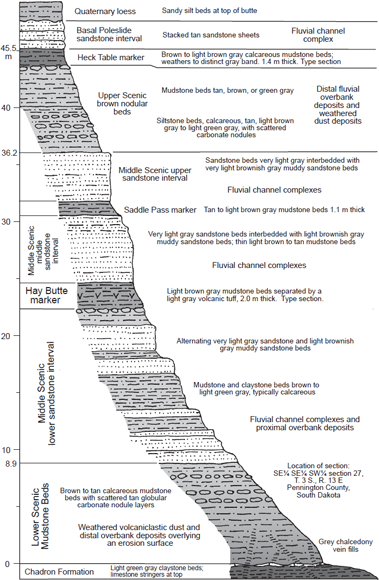
The basal contact of the Scenic Member is where green-gray claystone beds of the upper Chadron Formation abruptly change into brown mudstone beds of the basal Scenic. Claystones tend to have abundant clay with little or no silt grains and have a smooth, nongritty texture. Mudstones contain roughly equal amounts of silt and clay and thus have a slightly gritty texture. The contact also has scattered thin white limestone or silica stringers at the top of the Chadron rocks. The Chadron/Scenic contact is not flat but was an erosional contact with high relief, as seen by thickness variations in Scenic Member. The Scenic Member ranges from a minimum total thickness of 39.5 m to a maximum of 76.6 m in the North Unit of Badlands National Park. This variation in thickness is largely caused by ancient topographic relief on the basal contact of the Scenic Member (Fig. 2.4).
If the uppermost Chadron and the lowest Scenic rocks are within normal polarity zones, as indicated by Tedford et al. (1996) and Prothero and Whittlesey (1998), then an estimate of the amount of time missing in the Chadron/Brule erosional contact can be made. The Chadron rocks are latest Eocene in age and the Brule rocks are early Oligocene (Tedford et al., 1996; Prothero and Emry, 2004). The youngest late Eocene normal polarity zone is zone C15n (Fig. 2.2). The oldest early Oligocene normal polarity zone is C13n, which had a duration of 1.05 million years (between 34.8 Ma and 33.75 Ma; see Luterbacher et al., 2004). Thus, at least 1.05 million years is missing at this contact. Because the Eocene–Oligocene boundary occurs within C13r (Luterbacher et al., 2004), the complete rock and fossil record across the Eocene–Oligocene boundary is not preserved in Badlands National Park.
The Scenic Member has three subdivisions: the brown mudstone beds of the lower Scenic, the muddy sandstone beds middle of the middle Scenic, and the gray to brown mudstone beds of the upper Scenic (Plate 4). The lower Scenic sequence is characterized by thick beds of brown mudstone. The mudstones are typically calcareous and can contain globular carbonate nodules, especially in the upper part of the unit, where they are typically arranged into nodule layers. The lower Scenic brown mudstone beds outcrop as low, rounded hills below the steep cliffs of the middle Scenic muddy sandstone beds. Channel sandstones are rare in the lower brown mudstone beds and tend to be isolated ribbons. Thin but locally widespread limestone sheets containing fossil freshwater snail shells, ostracod carapaces, and algal fossils are scattered in the lower Scenic brown mudstones. The lower Scenic brown mudstone unit is one of the most widespread units in the North Unit of Badlands National Park, blanketing the basal Brule contact. Its thickness ranges from as little as 12.6 m on Chadron highs to as much as 65.3 m in the base of the large paleovalleys cut into the Chadron Formation (Fig. 2.4). Fossils are scattered throughout this unit as discrete bone beds, such as the Big Pig Dig quarry. The lower brown mudstone beds were well known to the early vertebrate paleontologists, who called it the red layer (Wortman, 1893; Sinclair, 1921b) for the red hematite staining of the fossils in this unit, or the Lower Nodules or Lower Nodular Zone for the carbonate nodules (Wanless, 1921, 1923; Bump, 1956).
The middle Scenic is characterized by multiple stacks of very thick, widespread, light gray muddy sandstone blankets that are separated by thin to thick, brown or red mudstone and claystone beds (Plate 4). These sandstone blankets are well bedded and are composed of thick to thin sheets of alternating very light gray, very-fine-grained sandstone interlayered with light brownish-gray muddy sandstone. The individual thin sandstone sheets locally surround scattered thick lenticular sandstone ribbons. The individual blankets are separated by thin to thick brown to red mudstone and claystone sheets that rarely extend for more than a kilometer along the outcrop. Bedding is not obvious in the mudstone and claystone sheets, but Clark, Beerbower, and Kietzke (1967:78) report that the claystone beds show thin horizontal bedding on fresh-cut surfaces when coated with kerosene. Together, the white, well-bedded sandstone blankets that are separated by brown to red mudstone beds give the middle Scenic outcrops a distinct banded pattern on steep, steplike slopes. Fossils are rare in the middle Scenic sandstone blankets, but they do occur in bone beds at a few localities at the bottoms of a sandstone ribbons and in carbonate-rich mudstones below the middle Scenic mudstone marker beds.
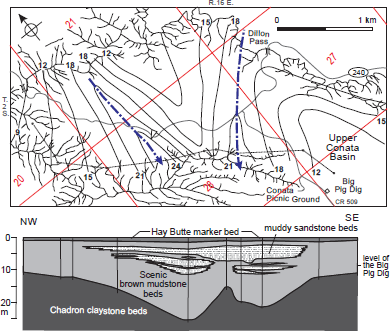
2.4. Topography cut into the Chadron Formation in the Upper Conata Basin, Badlands National Park. Top, Map showing thicknesses between the base of the Scenic Member of the Brule Formation and the Hay Butte marker. The contours are lines of equal thicknesses (in meters) called isopachs. Isopachs that are low indicate Chadron hills and those that are high values indicate valleys, with dot–dash arrows showing the drainages at the start of Scenic deposition. The thin black lines show ridge crests along the Badlands Wall. The arrow along State Highway 240 shows the viewpoint location and direction of Plate 4. Bottom, Cross section showing the thicknesses of various rock types in the lower Scenic below the Hay Butte marker along the badland ridge extending northeast from the Big Pig Dig. The location of the cross section is shown on the map with the dashed line. The dots along the cross section line on the map show the location of the sections shown by the vertical lines on the cross section. The cross section has a vertical exaggeration of 32.5×.
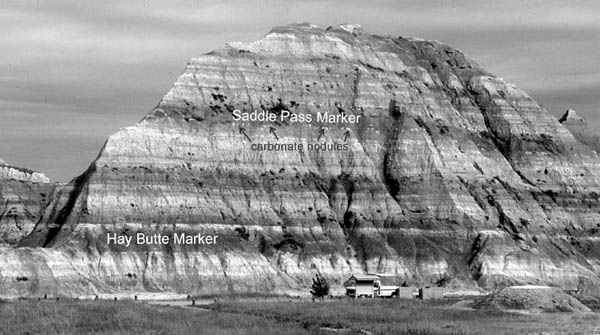
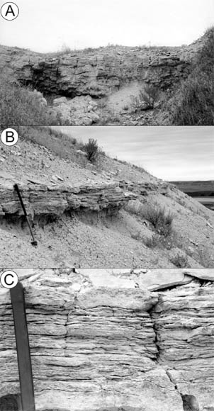
Two widespread mudstone marker units occur in the middle Scenic, the Hay Butte and Saddle Pass markers. The lower and most distinct of the widespread mudstone marker units is the Hay Butte marker. This informal stratigraphic unit is a thick complex of brown to gray mudstone beds that combine to form a unit averaging 1.9 m thick. The Hay Butte marker extends all along the Badlands Wall from Sheep Mountain Table to the northeast edge of Badlands National Park. The Hay Butte marker is one of the thickest and most pronounced brown bands on the Badlands Wall (Fig. 2.5). In the middle of the Hay Butte marker is an individual mudstone bed that contains abundant euhedral, six-sided biotite crystals as large as the size of medium sand. Other euhedral crystals of apatite, monazite, and rare sphene occur in this mudstone bed. This crystal-rich mudstone bed is most obvious on the west side of the Badlands National Park around Sheep Mountain Table but becomes indistinct on the eastern margin of the park. This bed is a volcanic tuff and represents a timeline within the Hay Butte marker. The older topography that was cut into the Chadron Formation was buried by the time of the deposition of the Hay Butte marker. The marker rests on sandstone blankets of the lower middle Scenic in the Brule paleovalleys and on the lower brown mudstones of lower Scenic on the Chadron highs (Fig. 2.4). Because the beds of the Hay Butte marker were deposited essentially on a level plain, the thickness of the Scenic rocks between the Chadron/Scenic contact and the Hay Butte marker records the topographic relief cut into the Chadron Formation. The Scenic rocks below the Hay Butte marker range in thickness from a minimum of 10.7 m to a maximum of 38.1 m. Therefore, the erosional contact cut into the Chadron Formation had a local maximum relief of 27.4 m. The Hay Butte marker is named for the long butte just west of the southeast branch of Sage Creek and west of the Pinnacles. The type section of the Hay Butte is in the type section of the Scenic Member, just south of the town of Scenic (Fig. 2.6).
2.5. Hay Butte and Saddle Pass marker beds within the middle Scenic Member sandstone beds at the Conata Picnic Ground, Badlands National Park. Photo by the authors.
The second marker bed in the middle Scenic is the Saddle Pass marker. This informal stratigraphic unit is composed of a thick, lower, brown mudstone bed and a thinner upper red to brown mudstone or claystone bed. Together they average 1.5 m thick, though the marker thins to a minimum of 0.6 m to the west and has a maximum thickness of 2.2 m in the east. East of the Wanless Buttes (Fig. P.1), the Saddle Pass marker always overlies a widespread carbonate nodule bed. West of the Wanless Buttes, the Saddle Pass marker thins and the underlying carbonate nodules disappear. However, like the Hay Butte marker, the Saddle Pass marker occurs along the entire Badlands Wall in the North Unit of Badlands National Park, typically appearing as a persistent brown band occurring on average 11 m above the Hay Butte marker (Fig. 2.5). The Saddle Pass marker is named for Saddle Pass, a notch through the Badlands Wall with a steep trail (the Saddle Pass Trail) north of the Loop Road about 2.5 km northwest of the Ben Reifel Visitor Center. Its type section is located adjacent to the Saddle Pass trail (Fig. 2.7).
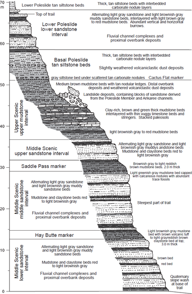
The sequence of rocks in the upper Scenic is characterized by a series of gray to brown mudstone beds that weather into smooth buff-colored slopes above the steplike cliffs of the middle Scenic rocks (Plate 4). West of the long ridge extending north of the old town of Imlay (the Imlay Table, Fig. P.1), the upper mudstone beds are brown to tan and contain abundant globular carbonate nodules. Fossils are fairly abundant in these nodular mudstones and were called the Upper Nodular Zone by Bump (1956). These western mudstone beds are capped by a third marker unit, the Heck Table marker, which is characterized by a thick basal brown mudstone bed capped by a claystone bed. Together these two beds make a marker bed with an average thickness of 1.4 m and weather into a prominent gray band that occurs at the top of the Scenic Member at the type section (Bump, 1956). The Heck Table marker is named for a butte southeast of Scenic, and its type section is at the top of the Scenic type section (Fig. 2.6). The Heck Table marker disappears to the east at the north end of Imlay Table. East of Imlay Table, the upper Scenic is characterized by a three-part sequence of a lower tan mudstone interval containing abundant globular masses of carbonate, a middle gray clayey mudstone unit riddled with thin stringers and discontinuous thin ledges of limestone, and an upper sequence of medium brown (buff) mudstones below the siltstone beds of the Poleslide Member. Fossils are extremely rare in the middle gray clayey mudstone beds of the eastern upper Scenic sequence. However, fossils can occur in scattered bone beds associated with the lower tan mudstone and uppermost buff mudstone beds of the eastern upper Scenic sequence. The thickness of the upper Scenic sequence averages 9.1 m west of Imlay Table and 14.1 m east of Imlay Table. This abrupt change in thickness is because the contact between the mudstone beds of the upper Scenic to the siltstone beds of the Poleslide rises by 5 m from the Heck Table marker to a new marker bed at the base of the Poleslide Member to the east (Fig. 2.1). The uppermost Scenic buff mudstone beds in the east gradually change into siltstone beds of the lower Poleslide sequence to the west in the vicinity of the north end of Imlay Table. Siltstones are composed of mainly silt grains with less than a third clay, so they are coarser, with a gritty texture relative to mudstones.
2.6. Type section of the Scenic Member of the Brule Formation at a location just south of Scenic, South Dakota, as given by Bump (1956). The section includes the type sections for the Hay Butte and Heck Table markers of the Scenic Member.
The base of the Poleslide Member east of Imlay Table occurs at the base of a marker bed called the “Cactus Flat bentonite bed” by Stinchcomb, Terry, and Mintz (2007). This bed is a light gray structureless siltstone bed averaging 0.7 m thick and is overlain by the first massive tan siltstone beds of the lower Poleslide. Stinchcomb (2007) separated the minerals from this bed and found some euhedral biotite, feldspar, and zircon crystals suggesting its origin as a tuff. However, in the field this bed has no obvious concentration of abundant euhedral crystals, shows no significant concentration of smectite clays relative to the overlying and underlying beds, and its bottom contact is diffuse. Soil development at the Scenic/Poleslide boundary was intense and caused its euhedral minerals to be dispersed and its lower contact to mix with the underlying mudstone beds. In addition, the “Cactus Flat bentonite bed” may be the extreme distal end of a volcanic ash (like the Hay Butte tuff at the east margin of Badlands National Park), but it is more properly called the Cactus Flat marker bed. Its type section is in the Norbeck Pass area.
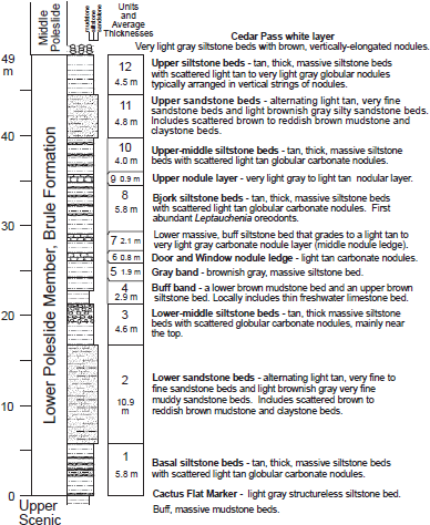
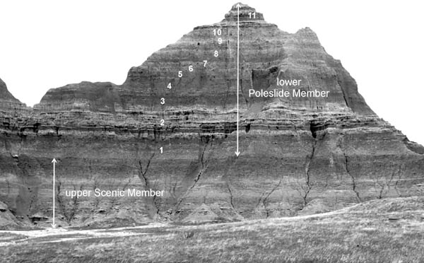
Like the Scenic Member, the Poleslide Member can be divided into lower, middle, and upper subdivisions, as was recognized by Bump (1956) in his description of the Poleslide type section. The lower Poleslide sequence is characterized by a combination of massive, stacked, thick siltstone beds, widespread blanket sandstones, and a thick interval of mudstone. Locally, the lower Poleslide sequence also has broad limestone sheets containing freshwater snail shells, ostracod carapaces, and algal fossils, but these limestone beds are limited in number. The detailed stratigraphy of the lower Poleslide rocks is remarkably consistent. The lower Poleslide sequence in the eastern half of Badlands National Park is composed of 12 stratigraphic units that always occur in the same order and retain their distinctive features (Fig. 2.8). These units extend from the east side of the North Unit of Badlands National Park to the Wanless Buttes, a straight-line distance of 35 km. The average thickness of the lower Poleslide sequence in these eastern outcrops is 50.9 m. Most of the outcrops of the lower Poleslide rocks in this eastern area are in steep-sided isolated buttes (Fig. 2.9). The most accessible areas to these rocks in the east are in the Cedar Pass and Norbeck Pass areas. Fossils in the lower Poleslide Member are not concentrated as distinct bone beds but are scattered throughout the siltstone beds. In this sequence, Unit 7 (Fig. 2.8) is at the boundary between the Merycoidodon-dominated assemblages below and the Leptauchenia-dominated assemblages above. This faunal boundary is considered to be the boundary between the Orellan and Whitneyan land mammal ages. To the west at Sheep Mountain Table, the sequence of units is not like those in the east. The base of lower Poleslide sequence in the west is marked by a well-bedded silty sandstone blanket directly above the Heck Table marker. Above this unit the lower Poleslide is characterized by three massive tan siltstone sequences that are separated by a brown mudstone unit and a thick sequence of well-bedded muddy sandstone sheets. The lower Poleslide sequence averages 50 m thick on Sheep Mountain Table, and the rocks are exposed in increasingly steep outcrops at the base of the table. As in the lower Poleslide sequence on the east side of Badlands National Park, the lower thick siltstone sequence contains abundant Merycoidodon fossils but no known Leptauchenia fossils. The exact stratigraphic position of the first abundant Leptauchenia fossils is still unknown on the steep flanks of Sheep Mountain Table.
2.7. Section at Saddle Pass along the Saddle Pass trail. This includes the type section of the Saddle Pass marker.
2.8. Units of the lower Poleslide Member of the Brule Formation in the eastern North Unit, Badlands National Park.
The middle sequence of the Poleslide Member is characterized by very thick, massive, very light gray siltstone beds that contain abundant globular carbonate nodules. These carbonate nodules are typically vertically stacked, suggesting they formed around roots and burrows. The middle Poleslide beds are exposed only on the mostly vertical flanks of Sheep Mountain Table as short sequences at the tops of isolated buttes along the Badlands Wall and in the Cedar Pass area. Like at Sheep Mountain Table, the middle Poleslide rocks are exposed almost exclusively in vertical cliffs in the Cedar Pass area. Thicknesses of the middle Poleslide siltstone beds are 32.0 m at Cedar Pass and 19.4 m on the east flank of Sheep Mountain Table. The variations of thickness of the middle Poleslide sequences between Cedar Pass and Sheep Mountain are caused by the nature of the upper Poleslide sediments. These upper Poleslide sediments are well-bedded fluvial deposits that were deposited in the Sheep Mountain Table area while massive siltstone deposits, representing wind transported dust deposits, were accumulating in the Cedar Pass area.
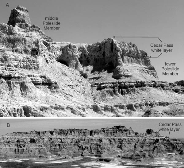
Overlying the lower Poleslide sequence at Cedar Pass is a prominent white bed that is silty and structureless, contains yellowish-brown vertically stacked carbonate nodules, and is 5.5 m thick (Fig. 2.10). Freeman Ward (1922:29) was the first to describe this bed as a light gray to white very fine “sandstone” that weathers into fine angular fragments that he called “road metal.” This bed has since been the focus of a stratigraphic correlation problem for 90 years. Harold Wanless (1923) interpreted this bed to be volcanic ash and correlated it with the white tuff at the top of Sheep Mountain Table. Nicknish and Macdonald named the tuff on top of Sheep Mountain Table the Rockyford Ash in 1962, and Harksen and Macdonald (1969) and Harksen (1974), accepting Wanless’s correlation, called the Cedar Pass white bed the Rockyford Ash. This correlation required that the overlying siltstones at Cedar Pass become part of the Sharps Formation, for the Rockyford Ash is the basal unit of the Sharps (Harksen, Macdonald, and Sevon, 1961). These upper rocks at Cedar Pass were mapped as the Sharps Formation by Raymond and King in 1976. However, Wanless in 1923 noted a problem: if these two white beds correlate, then the thickness of the upper White River beds at Sheep Mountain Table (91 m thick; Bump, 1956) was about twice the thickness of the upper White River beds at Cedar Pass (49 m thick). Wanless discussed two geologic possibilities for this discrepancy. The first was greater tectonic subsidence in the Sheep Mountain Table area; the other was a greater accumulation of sediment near the presumed source of the sediment. (Wanless favored the latter hypothesis.) A third possibility is that these two white layers are not the same bed. To test this last hypothesis, the features of the two beds have been compared, and the white bed at Cedar Pass was traced to the west along the high buttes of the Badlands Wall. First, the Rockyford ash on Sheep Mountain Table is a true volcanic tuff with a distinct base, a diffuse top, abundant crystals of euhedral biotite and hornblende, and less abundant zircon, apatite, and green clinopyroxene (E. E. Larson, pers. comm., 1998). The white bed at Cedar Pass has few euhedral biotite grains and no hornblende, and most of the heavy minerals are heavily weathered and abraded, not unlike the heavy minerals in the underlying and overlying siltstone beds. The bottom contact of the Cedar Pass bed looks sharp from a distance but is diffuse when examined up close. As the Cedar Pass white bed is traced to the west, it is still a distinct bed at the Pinnacles Overlook near the north entrance of Badlands National Park. Farther to the west at the Wanless Buttes, the 12 recognizable units of the lower Poleslide are overlain by a thick sequence of massive very light gray siltstone beds, identical to the beds of the middle Poleslide on Sheep Mountain Table (Fig. 2.1). No distinct white bed occurs at the base of these siltstone beds at either the Wanless Buttes or Sheep Mountain Table. The White River tuffs came from sources to the west (Larson and Evanoff, 1998), so the disappearance of a thick volcanic tuff to the west is quite unlikely. This thick white bed is an important and distinctive marker at the base of the middle Poleslide sequence in the east half of the North Unit of Badlands National Park and is an informal stratigraphic unit named the Cedar Pass white layer with its type section at Cedar Pass. In addition, the massive siltstones above the Cedar Pass white layer at Cedar Pass are part of the Poleslide Member, not part of the Sharps Formation.
2.9. The Scenic/Poleslide contact as exposed in the butte just east of the Headquarters, Badlands National Park. The contact is between the last mudstone unit of the Scenic Member and the first siltstone unit of the Poleslide Member. The numbers refer to the units within the lower Poleslide Member (Fig. 2.8). Photo by the authors.
The upper sequence of the Poleslide Member is characterized by alternating light brown mudstone and light gray siltstone sheets that occur near the top of Sheep Mountain Table. These rocks erode into ledgy vertical cliffs and spires characterized by Wanless (1923:230) as “organ pipe weathering” (Plate 5). Channels with broad lenticular cross sections and filled with coarse sandstone occur in these beds on the south end of Sheep Mountain Table. These channel deposits contain the artiodactyl Protoceras (Harksen, 1974). The upper Poleslide sequence is 20.7 m thick on Sheep Mountain Table and is capped by the Rockyford Ash at the base of the Sharps Formation. Upper Poleslide beds occurs 32 m above the Cedar Pass white layer at Millard Ridge on the east side of the Badlands National Park. Here a widespread fluvial sandstone blanket occurs within typical Poleslide massive siltstone beds. The bottom of this sandstone blanket is the base of the upper Poleslide Member in the Cedar Pass area.
The Sharps Formation conformably overlies the White River Group in the South Dakota Badlands. The Sharps Formation was named by Harksen, Macdonald, and Sevon (1961) for a thick sequence of massive, pinkish-tan, sandy siltstone beds containing globular carbonate nodules. The total thickness of the Sharps Formation at its type section near Sharps Corner, Shannon County, South Dakota, is 120.4 m. The basal bed of the Sharps Formation is a white tuff called the Rockyford Ash, named by Nicknish and Macdonald (1962) for outcrops near Rocky Ford in Shannon County, South Dakota. The type section is on the top of Sheep Mountain Table, where the 9.1 m thick tuff is capped by the basal siltstones of the Sharps. The fauna of the Sharps (Harksen, Macdonald, and Sevon, 1961) is early Arikareean in age.
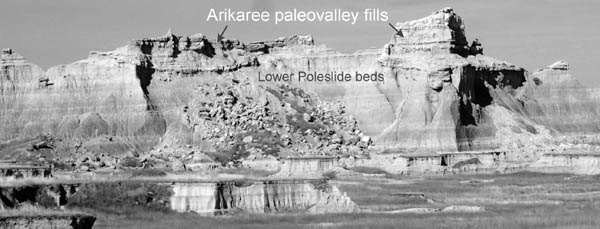
The high buttes along the Badlands Wall from Millard Ridge to the Wanless Buttes are capped by coarse conglomerates representing basal deposits of paleovalleys filled with rocks containing fossils of middle Arikareean age (Parris and Green, 1969; Harksen, 1974). A typical valley fill has a basal conglomeratic coarse-grained sandstone sheet with pebbles of siltstone and sandstone, overlain by alternating horizontal beds of light gray sandy siltstone and sandstone with rare mudstone and claystone beds. On Millard Ridge (east of Cedar Pass), the cumulative thickness of sandstone beds comprises 45 percent of one of the thick valley-fill sequences. These channel fills cut into the middle and lower Poleslide siltstones to a variety of levels (Fig. 2.11). Most cut down to about the level of the Cedar Pass white layer, but some were incised to 13 m below the base of the Cedar Pass white layer (Harksen, 1974), while others have a base as high as 32 m above the base of the Cedar Pass white layer. The fauna of these channels is Arikareean in age (Parris and Green, 1969) and includes the late Arikareean giant entelodont Daeodon (previously known as Dinohyus). Late Arikareean faunas are late Oligocene in age (Tedford et al., 2004) and are younger than the early Arikareean (late early Oligocene) faunas of the Sharps Formation. Though informally called the Sharps Channels, the abundance of sandstone beds and a late Arikareean fauna in these paleovalley fills suggest they are more properly part of the Arikaree Group. These paleovalley fills require additional mapping and faunal analysis, but their position in vertical cliffs and on top of high buttes makes them difficult to study.
2.10. Views of the Cedar Pass white layer. (A) Close-up of the Cedar Pass white layer on the east side of Cedar Pass. The thickness of the marker bed in this area is 5.5 m. (B) View from the north-northeast of the butte west of Cedar Pass showing the distinct band of the Cedar Pass white layer. Photos by the authors.
2.11. Arikaree sedimentary rocks filling two paleovalley sequences cut into lower Poleslide Member siltstone beds on a butte west of the east end of the Medicine Root Trail, North Unit, Badlands National Park. Here the paleovalleys cut through Unit 11 down to Unit 8 of the lower Poleslide Member. Photo by the authors.
Sedimentary rocks form from a series of processes acting at different times. In the case of the rocks of the White River Group, the original sediment was deposited by rivers and streams (fluvial processes), in lakes (lacustrine processes), or by wind (eolian processes). Once the sediment was deposited and exposed at a land surface, weathering occurred from rain and air. Burrowing animals and plant roots churned up and chemically altered the sediment to form a soil that would be buried by the next depositional event. Once the sediment was buried, it was compacted, and the pore space between the grains was filled with mineral cements to become a sedimentary rock, a process known as lithification. The cementation of sediment into rock can occur early or it can take millions of years. In the end, sediments become rocks that are later exposed by erosion for geologists to study.
The sediments of the White River Group came from two sources. One source was the Black Hills, and the other was volcanic eruptions far to the west. The local epiclastic sediment is indicated by such minerals as quartz, hornblende, tourmaline, epidote, and the feldspars microcline, orthoclase, and plagioclase. Unique mineral assemblages in White River sandstone stream deposits reflect the mineralogy of the rocks at the headwaters of the ancient streams in different parts of the Black Hills. Streams from the southern Black Hills transported sand containing a large amount of garnet and black tourmaline, as well as rare orange sphene and brown hornblende (Seefeldt and Glerup, 1958). Streams from the northern Black Hills transported sand containing abundant magnetite and greenish hornblende, less abundant lemon-yellow sphene, and rare gold (Ritter and Wolfe, 1958). These epiclastic minerals were mixed with volcanic materials, primarily volcanic glass and euhedral crystals like those found in the tuff beds.
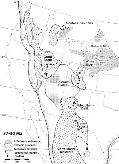
The White River Group was deposited during one of the greatest episodes of volcanic eruption in the Cenozoic, which geologists call the ignimbrite flare-up. Huge eruptions of volcanic ash occurred from the degassing of magma chambers and the collapse of the overlying rocks, thus forming a caldera, a typically circular volcanic basin many kilometers in diameter. Some of these eruptions were truly enormous (Best et al., 1989), with eruptions producing 1000 to 5000 km3 of volcanic materials. (For comparison, the Mount St. Helens eruption of 1980 erupted 1 km3 of material.) Larson and Evanoff (1998) studied the mineralogy, geochemistry, and age relations of White River tuffs in Wyoming, Nebraska, and Colorado, and they determined that the vast majority of the volcanic sediments (called volcaniclasts) came from volcanic eruptions in the Great Basin of modern Nevada and Utah (Fig. 2.12). The White River Group has about 40 percent volcaniclasts at it base and as much as 80 percent volcaniclasts at its top (Swinehart et al., 1985). Given an average of about 60 percent volcaniclasts for the White River rocks, their original distribution over ~400,000 km2 of North Dakota, South Dakota, Nebraska, Colorado, and Wyoming, and the regional variation of their thicknesses, the total amount of volcaniclastic sediment in the White River Group is about 25,000 km3 (Larson and Evanoff, 1998). It was truly an ashy, dusty time.
2.12. Palinspastic reconstruction of the west-central portion of North America showing the active volcanic provinces during the deposition of the White River sequence. Modified from Larson and Evanoff (1998).
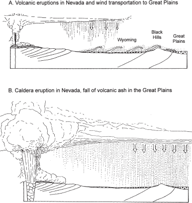
How did this volcanic material get transported to the Badlands? Most of it did not come in from direct ashfalls through the atmosphere. Most of the volcaniclasts were erupted by volcanoes and carried by winds as ash to sites west of the Badlands, where winds picked up the ash and local epiclasts to make dust that fell to the east (Fig. 2.13A). In the earlier and wetter times of White River deposition in the Badlands, this dust fell and was weathered into clay or was picked up by streams and deposited as fine-grained overbank deposits during floods. Evidence of this process is preserved as ash shards mixed with muds in the overbank deposits of rivers in the White River Group (Evanoff, 1990b; Lukens, 2013; Lukens and Terry, 2013). Eventually the climate dried out and the dust accumulated into thick dust deposits, called loess. Occasionally there were enormous eruptions that spread ash clouds thousands of kilometers downwind over the Great Plains, where the ash fell onto the land, forming volcanic ash deposits (Fig. 2.13B). The South Dakota Badlands were far downwind from most of the volcanic eruptions, and as a result there are only two distinctive tuffs known in the White River Group in the South Dakota Badlands.
Much of the original sediment of the Chamberlain Pass Formation, Chadron Formation, and Scenic Member of the Brule Formation was deposited by rivers and streams (fluvial processes). Approximately a third of sediments that made up the Poleslide Member of the Brule Formation are fluvial deposits. The coarse-grained channel deposits occur in two groups: as long, linear deposit with lenticular cross sections called sandstone ribbons and as sandstone blankets that are made of stacked thin sandstone sheets. The deposits of ancient stream channels rarely preserve the form and distribution of an individual channel in which water flowed at any one time. Over time, the channel swings from side to side, modifying preexisting channel deposits and creating a channel belt, or a broad band of internested individual channel deposits. For example, if the channel has limited movement from side to side, it will have a narrow channel belt that will be preserved as a ribbon sandstone body. The outcrop of a channel deposit that is preserved today actually reflects the geometry of the channel belt, not the individual channel in which water flowed at any one time. The two types of channel deposits in the White River Group reflect two kinds of fluvial depositional environments that are primarily related to the permanence of the flowing water and to the interconnectedness of the fluvial system.
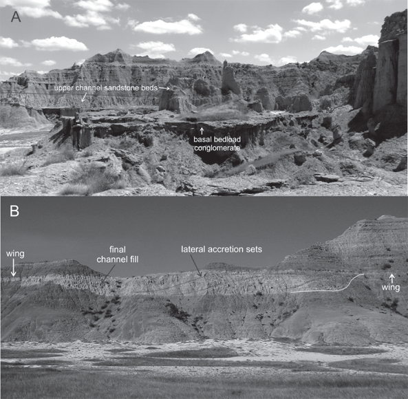
Isolated sandstone ribbon channel deposits are characteristic of the Chadron Formation, and they are locally common in the Poleslide Member of the South Unit of Badlands National Park (Fig. 2.14A). Sandstone ribbons also rarely occur in the lower mudstones of the Scenic Member (Fig. 2.14B). They include a central ribbon filled with basal gravels, coarse sandstone in the middle, and muddy sandstones at the top. The lower coarse sandstones in the ribbons contain thick cross bed sets indicating stream flow from the west or northwest toward the east or southeast. These channel deposits typically are attached to one or more “wings,” or tabular sandstone and muddy sandstone sheets that laterally extend from the tops of the ribbons and pinch out into the surrounding distal, well-bedded mudstones. Water flowed in the central channel throughout much of the year, but during floods, the rising waters dumped sand into broad sheets lateral to the channel to form splay deposits, and mud was deposited far from the channel as overbank deposits. Many of the channels have coarse-grained sediment derived from the Black Hills, but some isolated sandstone ribbons contain mudstone pebbles and fine-grained sand derived from sources within the White River Group. These sandstone ribbons containing intraformational clasts represent streams draining the Great Plains that were tributaries to the main trunk streams that carried sediment from the Black Hills. The areal geometry of the ribbons is typically a broken-stick pattern of long, straight reaches and short, abrupt bends. The bedding in the straight reaches is typically a series of thick internested cuts and fills, with the total thickness and width of the ribbon along the straight reaches less than in the bends. The thick and wide lenticular cross section of the ribbon at a bend contains lateral accretion deposits inclined toward the outside curve of the bend (Fig. 2.14B). These lateral accretion deposits represent the building of a point bar on the inside of the bend. The coarser basal gravels and sandstones of the ribbons are more resistant to erosion than the finer-grained upper channel and muddy overbank deposits, so after erosion the basal deposits will be preserved as long, sinuous ridges in badlands outcrops. The isolated sandstone ribbons contain a variety of aquatic animal remains, including the bones of freshwater fish, turtles, and alligators and the shells of freshwater unionid mussels. Locally, the channel deposits will contain bone beds in isolated pockets at the base of the channel where bones were concentrated as large sediment clasts.
The fluvial deposits of the middle Scenic Member and the Poleslide Member of the Brule Formation are dominated by sandstone blanket deposits. These sandstone blankets are thick sequences of interbedded sandstone and muddy sandstone sheets. These sandstone blankets are separated by wide, relatively thin sheets of mudstone or claystone that do not typically extend more than a kilometer along the Badlands outcrops. These muddy sediments were deposited as ponded overbank deposits in lows on the sand sheet surfaces, as indicated by the remnants of laminated bedding within them (Clark, Beerbower, and Kietzke, 1967). The alternating light gray sandstone blankets and brown to red mudstone/claystone sheets produce the striking banded outcrops of the middle Scenic Member in Badlands National Park (Plate 4, and the rocks between the marker beds in Fig. 2.5). Sandstone ribbons are scattered within these sandstone blankets, but they have different bedding features than those of the isolated sandstone ribbons. They are typically broad ribbons with very thin beds of sandstone that are horizontal or inclined at a low angle. They show abundant parting lineation, long linear streaks of grains on the bedding surfaces, and rare cross beds. The sandstone blankets are typically stacked, and the lateral extent of the stacked blankets can be quite remarkable. The middle Scenic blankets occur in three stacked sequences separated by the Hay Butte and Saddle Pass marker beds. The lower stack of sandstone blankets below the Hay Butte marker is limited by the distribution of basal Scenic paleovalleys, but the middle and upper stacks of sandstone blankets extend along the entire Badlands Wall of the North Unit of Badlands National Park, a north–south distance of 22 km and an east–west distance of 58 km. The edge of the upper stack of sandstone blankets above the Saddle Pass marker occurs in the vicinity of the Ben Reifel Visitor Center, where the sandstone blanket thins and grades into tan mudstone beds that contain massive carbonate nodules. The fossil site at the Ben Reifel Visitor Center (the Saber Site) is in these tan mudstone beds.
2.13. Origin of the White River sediments. (A) Normal deposition during White River time. Fine-grained volcaniclastic sediment originates from volcanic eruptions located in modern-day Nevada and Utah. Surface winds transport the volcaniclastic sediments as dust that mixes with fine-grained epiclastic material derived from local mountains. The dust falls into the Great Plains, where it either is reworked by stream or accumulates as loess. (B) An eruption of a huge caldera in modern Nevada or western Utah pushes fine-grained volcaniclastic material into the upper atmosphere. Winds carry this volcanic ash to the Great Plains, where it is deposited as a volcanic ash.
The well-bedded sandstone beds in the lower and upper Poleslide sequences are similar stacked sandstone blankets but contain increasing amounts of siltstone sheets between the sandstones sheets in progressively higher fluvial deposits. Bone accumulations are rare in the Poleslide sandstone blanket deposits and occur only in the coarse sandstone ribbons within the sandstone blankets (for example, the Protoceras channels of Sheep Mountain Table).
2.14. Cross sections of ribbon sandstone bodies in the White River Group. (A) Middle Poleslide channel-belt deposit showing the coarse basal conglomerate beds and the upper sandstone to muddy sandstone beds in the background as in the midground. The coarse basal conglomerate is filled with sediment derived from the Black Hills, indicating that the stream flowed from the Black Hills. Medium- to small-scale cross beds in these deposits indicate that the flow was toward the viewer. (B) Cross-sectional view of a channel-belt deposit in the lower Scenic brown mudstone interval. The outcrop was at a bend in the channel belt, so there are large, low-angle cross beds that represent lateral accretion deposits in a point bar. The channel migrated to the outside of the bed (to the left), and the point bar expanded toward the left. The final channel in the channel belt is represented by the sandstone fill on the left side of the channel. This stream channel occasionally flooded, producing sheet sands lateral to the top of the channel-belt deposits. These lateral sheet sandstones are labeled “wings” in the diagram. This channel-belt deposit has no basal coarse conglomerate and is filled with sandstone and muddy sandstone beds, indicating that this channel had its headwaters in the Great Plains, not the Black Hills. Photos by the authors.
The two kinds of fluvial deposits found in the White River Group in the Badlands reflect the kinds of sediments that are transported and the persistence of the stream flow in the rivers and streams. All of the streams that deposited the White River fluvial sediments were mixed-load streams, or streams that carried both gravel and coarse-grained sand as a bed load, and fine silt and clay grains as suspended load. The source of the coarse bed-load material was mainly from the Black Hills. The muddy suspended load was from erosion of older clay-rich rocks such as the Pierre Shale or, in the case of the lower brown mudstones of the Scenic Member, the claystone hills of the eroded Chadron Formation. Most of the suspended load in the streams of the White River Group was from dust derived from volcanic and epiclastic sources to the west.
The isolated ribbon sandstones of the Chadron Formation, the lower Scenic brown mudstones, and the Protoceras channels were deposited by rivers and streams with water flow throughout the year (perennial streams). This is indicated by their relatively coarse-grained, fairly well-sorted channel deposits and associated fossils of aquatic organisms. The freshwater unionid mussels in these channel deposits indicate that these streams had constant flow throughout the year, had well-oxygenated waters, and were part of an extensive interconnected river system. Freshwater mussels are dispersed by fish that carry their larvae as parasites attached to their gills and fins. The clam larvae drop off the fish at a certain point in their development and grow to become filter feeders on the stream floor. Fish will not inhabit streams that are dry for much of the year and cannot get to water bodies not connected by streams. Therefore, freshwater mussels will not live in intermittent streams or isolated water bodies, such as groundwater-fed lakes and ponds. The east-to-southeast current flow directions and the alligator fossils in the channels of the Chadron Formation indicate connections with an ancient Mississippi River system.
The fluvial deposits represented by the sandstone blankets were deposited in a completely different kind of fluvial system. The coarser sediment in the sandstone blankets are derived from the Black Hills (Clark, Beerbower, and Kietzke, 1967), so they had sources similar to those of the isolated sandstone ribbons. However, while the streams of the isolated ribbons transferred sediment along discrete channels that had flow throughout the year, the streams of the sandstone blankets flowed only during floods, eventually spreading the water and the sediment in extremely broad sheets across the plains. The alternating wet and dry conditions for these deposits are indicated by features in the interbedded mudstone and claystone sheets. Some of these mudstone deposits have desiccation cracks (mud cracks) that show drying of originally wet muddy sediment. Some discrete sandstone ribbons occurred within the sandstone blankets, and these have been traced for many kilometers in the Badlands (Ritter and Wolfe, 1958). These broad, thin-bedded ribbons with abundant parting lineation structures are typical of flash flow in ephemeral streams. Ephemeral streams are those that are dry for most of the year and only flow during local storms or as a result of floods derived in the headwaters. These streams eventually lost their water downstream as it percolated into the muddy and silty sediments of the Great Plains. These streams probably did not flow beyond the Great Plains. The large carbonate masses found in the mudstone beds lateral to the upper sandstone blankets near the Ben Reifel Visitor Center were derived from carbonate-rich groundwater flowing from the edges of the river system into the lateral fine-grained mud deposits. That these rivers did not flow all year or connect with other river systems is indicated by the lack of aquatic animal fossils, such as fish, turtles, and alligator bones, and freshwater unionid mussel shells. Such river systems, called distributive river systems (Hartley et al., 2010; Weissmann et al., 2010), or rivers that break into multiple channels that fan outward onto a plain, drop their sediment into broad sheets, eventually forming stacked blankets of sand. A modern analog to most of the river systems of the Brule Formation would be in the Pampas of South America, where streams flowing out of the Andes lose their water into the porous loess deposits of the Pampas and as a result make broad fans of isolated channels and broad sheet sand deposits (Arthur Bloom, pers. comm., 1989).
Lacustrine (lake) strata of the White River Group are preserved at various stratigraphic levels across the region and are preserved as two main end members: those dominated by muds and clays (siliciclastics) and those dominated by calcium carbonate (limestone). These lakes formed as a result of geologic and possibly paleoclimatic factors. In Badlands National Park, particular intervals of lacustrine sedimentation include siliciclastic lakes in the middle of the Crazy Johnson Member of the Chadron Formation and limestone-dominated lakes at the contact between the Chadron and Brule formations and within the Poleslide Member of the Brule Formation. Siliciclastic lake deposits from the Crazy Johnson Member are interbedded with ancient river deposits (Terry and Spence, 1997; Terry, 1998). The lake deposits appear similar to normal clays and silts within this part of the stratigraphic section, but upon closer examination, particular types of fossils (stromatolites) are preserved within these deposits that confirm their origin as lacustrine strata. Stromatolites are interlayered masses of photosynthetic cyanobacteria and clay that form through the periodic addition of a thin layer of mud and clay to the surface of the cyanobacteria (Fig. 2.15). The bacteria, in an attempt to survive, grow through and recolonize the surface of the clay and mud. This process repeats, and over time, large stromatolitic bodies can be formed. The shape of the stromatolite body is a function of the water depth within which the cyanobacteria are growing. Very shallow waters and edges of lakes will have nearly flat layers of cyanobacteria. As water depth increases, the stromatolitic bodies become more domelike in shape (hemispheroids) as the photosynthetic cyanobacteria attempt to grow vertically in order to reach the light.
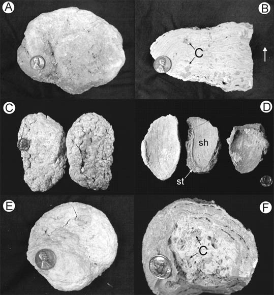
2.15. Photographs of lacustrine stromatolites. (A) Top view of stromatolite. (B) Cross section of stromatolite showing laminations and clay clasts (c) that were incorporated during growth. White arrow indicates original upward direction of growth. (C) Fossil bivalve shells encrusted by stromatolitic growth. (D) Interior view of bivalve shells (sh) encrusted by stromatolitic growth (st). (E) Exterior of oncolite. (F) Interior of oncolite showing laminations and clay clasts (c) that were incorporated during growth. Coin for scale in (A), (B), and (E) is 1.9 cm wide. Coin for scale in (C), (D), and (F) is 1.8 cm wide. Photos by the authors.
Stromatolites of the Crazy Johnson Member occur as laminar and hemispheroid masses. Some hemispheroids are up to 50 cm in diameter and 30 to 40 cm tall, although most are smaller (Fig. 2.15A). The large size of some of these stromatolites suggests that this was a stable perennial lake that existed for quite some time before eventually being buried by fluvial deposits. Some stromatolites show evidence of grazing, possibly by freshwater snails, which are known to be the primary predator of stromatolitic bodies. In addition to stromatolites, clams are also preserved in these deposits (Fig. 2.15D). Quite commonly the clamshells are covered with a layer of stromatolitic material that helped to preserve the shell (Terry and Spence, 1997; Terry, 1998).
In nearby ancient river deposits, rounded bodies of stromatolitic material are found as part of the coarser bed-load fraction of the channels. These rounded bodies, referred to as oncolites (Fig. 2.15F), represent the periodic movement of cyanobacterial masses by the river. As the oncolite rolls, its new resting place and orientation promotes the growth of new material in an upward direction on the oncolite mass. When the mass is moved again, the new orientation again promotes additional growth. Over time, this has a snowball-like effect on the growth of the oncolite. Some of these oncolites grew to the size of baseballs.
The contact of the Chadron and Brule formations is marked by occasional lacustrine limestone deposits. These deposits are easily seen in outcrops and can be recognized by their white color and resistance to erosion compared to the mudstones of the Badlands (Fig. 2.16). This difference in susceptibility to erosion has resulted in numerous tabletop buttes across the region, with the limestone layer acting as a protective layer to the mudstones beneath it. Specific examples of these lacustrine tabletop buttes can be found just south of the NPS Minuteman Missile Site at exit 116 on Interstate 90, and to the north of Interstate 90 between exits 114 and 116 (Fig. P.1).
The predominance of limestone versus siliciclastics as the primary lacustrine sediment is related to the conditions required for the formation of calcium carbonate in lakes. Limestone-dominated lakes require little influx of clastic sediment. Too much sediment and the clays and muds mix with calcium carbonate that is precipitating out of the water to form marls, in addition to inhibiting the growth of various forms of algae that biomineralize calcium carbonate. Lakes rich in limestone deposits generally form on stable landscapes away from rivers. It is also common for lakes that are dominated by limestone to be the result of carbonate-enriched groundwaters exposed at the surface, or springs. As these waters interact with the atmosphere, carbon dioxide dissolved in the water can escape into the atmosphere, thus making the waters less acidic and allowing calcium carbonate to precipitate.
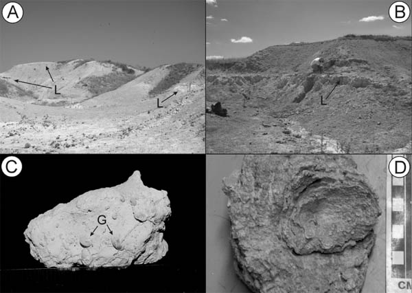
2.16. Photographs of lacustrine limestone caprock. (A) Massive lacustrine limestone representing a deeper part of an ancient lake. (B) Resistant layer of lacustrine limestone, which changes from massive at its base to progressively more laminated upward. Laminated sediments are indicative of shallower lake conditions. (C) Close-up of laminated lacustrine limestone. Pick for scale is approximately 60 cm long. Photos by the authors.
2.17. Photographs of lacustrine limestone in the Poleslide Member of the Brule Formation (A) Multiple layers of lacustrine limestone (L) separated by mudstone. Pick for scale is approximately 60 cm long. (B) Close-up of lacustrine limestone (L). (C) Lacustrine gastropods (G) in limestone. (D) Stromatolitic structure. Photos by the authors.
The lacustrine limestones south of the Minuteman Missile Silo are referred to as the Bloom Basin limestone beds (Evans and Welzenbach, 1998). These limestones range from 40 cm to meters in thickness and contain a rich diversity of aquatic life, including ostracods (a microscopic shelled arthropod), fish, turtles, charophytes (calcareous aquatic algae), and tracks of shorebirds (Evans and Welzenbach, 1998). These limestones, along with several other examples near the contact with the overlying Brule Formation, suggest that this time was geomorphologically stable across the region. This period of stability eventually gave way to active downcutting and erosion. Just northeast of Scenic, South Dakota, just north of the old Chamberlain Pass along Highway 44 (Fig. P.1), lacustrine limestones of the Chadron Formation are dissected and surrounded by sediments of the overlying Brule Formation. This downcutting created a complex paleotopography regionally across the top of the Chadron Formation that was eventually filled in by sediments of the Brule Formation (Benton et al., 2007; Evanoff et al., 2010).
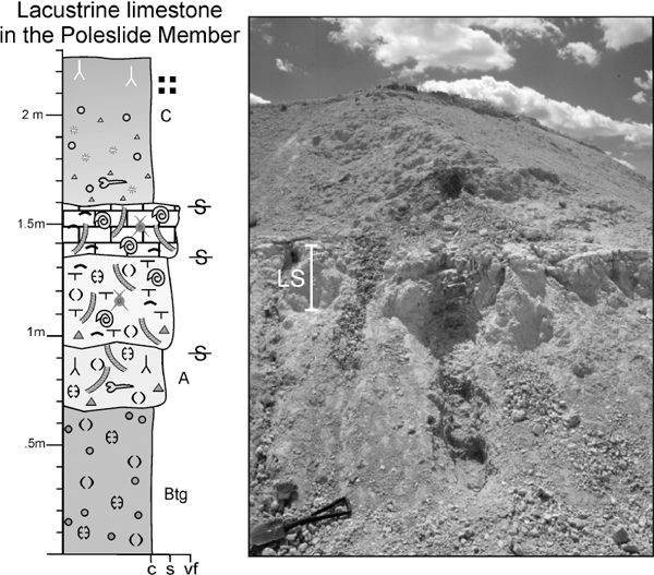
Lacustrine strata are also preserved within the middle of the lower Poleslide sequence (Unit 4, shown in Fig. 2.17). This depositional environment is unique within the Poleslide Member, which is dominated by eolian environments. The lake deposits range from relatively deeper water deposits in the center of the lake to shallow lake margin settings that interfinger with terrestrial environments (Fig. 2.18). At least two distinct episodes of lacustrine sedimentation are preserved. The lateral extent of these deposits is unknown because they are truncated by modern erosion. The central part of the lower lake level is preserved as a massive, chalky white micrite limestone. It rests on bluish-green, smectite-rich mudstones that weather similarly to the Peanut Peak Member of the Chadron Formation (Figs. 2.17, 2.18). The limestone is in turn capped by reddish marl that changes upsection to siliciclastics. Invertebrates and calcareous algae are the most common fossils within this part of the lake and include small gastropods, ostracods, and charophytes. Fish fossils are also present but are rare (Fig. 2.19). The upper lake level appears more laminated, possibly as a result of stromatolite growth. Domal stromatolites are found as float at the base of these exposures. Gastropods are also seen at this level.
2.18. Measured section and outcrop photograph of lacustrine limestone (LS) in the Poleslide Member. Limestone in the measured section is concentrated around 1.5 m level. See Fig. 3.6 for explanation of symbols. Photos by the authors.
Lake margin settings are marked by a transition to siliciclastic-dominated environments, but the nature of this transition is different depending on the individual lake level studied. The lowermost lake level preserves a lateral change to a more siliciclastic-dominated setting, whereas the uppermost lake level shows expansion of the lake system and the overlap of laminar, stromatolitic lacustrine limestone on top of terrestrial mudstone with fossil dung balls and sweat bee pupae. These strata represent a period of landscape stability. Because carbonate-dominated lakes form in response to low siliciclastic input, this suggests that this lake was set far away from an active channel system, that eolian influx was minor, or both.
These lacustrine limestones throughout the White River Group comprise a small part of the overall depositional history of these strata, but their paleoclimatic and paleogeomorphic requirements to form such deposits are important clues to the geologic history of the Badlands. The carbonate-rich nature of these lakes in the upper Eocene Chadron Formation suggests that climates by the end of the late Eocene were at times dry, that siliciclastic influx was at a minimum during stable geomorphic periods, or both. From a geologic standpoint, the source of these carbonate-rich waters is also interesting. It is likely that many of these lakes were fed by springs. Evans and Terry (1994) report the presence of tufa pipes (conduits for upward groundwater flow) that crosscut some of the lowest strata of the White River Group near the Bloom Basin limestone beds of Evans and Welzenbach (1998). The occurrence of these tufas was mapped by Evans and Welzenbach (1998) and Evans (1999), who postulated that these groundwater conduits could be related to the structural development of the Badlands. In essence, these tufa conduits followed faults to emerge at the land surface. The carbonate-rich nature of the groundwater could be explained as the result of hydrologic recharge from the ancient Black Hills as groundwater passed through various carbonate rock units, such as the Pahasapa Limestone.
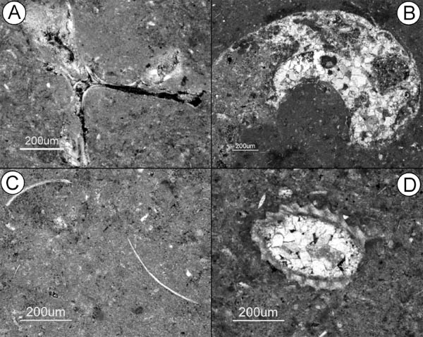
2.19. Photomicrographs of fossils from the lacustrine limestone in the Poleslide Member. (A) Fish vertebra. (B) Gastropod shell. (C) Ostracod shells. (D) Part of a charophyte. Photos by the authors.
The transition from stacks of mudstone beds in the upper Scenic Member into stacks of thick, massive siltstone beds in the Poleslide Member represents a change from predominantly wet conditions during Scenic deposition to the accumulation of thick eolian dust deposits, or loess, during the dry conditions of Poleslide deposition. The loessites, or lithified loess deposits, are typically tan to gray, massive thick siltstone beds that cover large areas with no associated channel deposits. Fossils of the fluvial Scenic deposits tend to occur in concentrations at local areas, called bone beds, but the fossils are typically scattered throughout the loessites. The fossil fauna of the siltstone beds are dominated by animals that prefer drier conditions, such as oreodonts, camels, running rhinos, and land tortoises. The dust was derived from sources to the west (Fig. 2.13) and includes a mixture of volcaniclastic and epiclastic silt-size particles that were picked up and transported by winds. Studies of modern dryland loesses (Pye and Tsoar, 1987) show that dust is derived from arid areas that have little vegetation to protect the silt from wind erosion. It accumulates in semiarid conditions that have enough vegetation to trap the dust but that are not wet enough to weather the dust or transport it by water. Subhumid and humid areas can have dust accumulation, but the dust weathers into clays or is redistributed by streams and rivers. Therefore, the transition from the mudstones of the Scenic Member to the siltstones of the Poleslide Member indicates a transition from wetter, probably subhumid conditions during the deposition of the Scenic Member into drier, probably semiarid conditions during deposition of the Poleslide Member. All of the eolian deposits of the Badlands are fine-grained loessites; no eolian sand dunes are known from the White River Group.
A broad erosional surface extended into the Great Plains from the Black Hills at the start of the deposition of the White River Group during the late Eocene. This surface was under intense weathering in warm and humid climates over a long period of time, forming the deep red soil of the Interior Zone. Gravel that had been deposited to the east of the Black Hills in the earlier Eocene was involved with this intense weathering, resulting in preserved gravels composed of only quartz, chert, and quartzite. As the land surface was slowly eroded, much of this gravel was spread across the land as lag gravels. Streams flowed across this surface and concentrated these quartz-rich gravels at the base of their channels. We know little of the geometry of these channels; they occur as isolated outcrops within the Chamberlain Pass Formation.
A major stream flowing out of the Black Hills and into the west side of the Badlands cut a major valley through the Interior Zone to a depth of about 27.4 m. This valley started to fill approximately 36 Ma as an influx of volcanic sediment from volcanic eruptions far to the west started to fall into the area as dust and ash, initiating the deposition of the Chadron Formation. This volcanic material was reworked and mixed with local epiclastic sediment by streams coming out of the Black Hills. These streams flowed throughout the year in channels that stayed in a narrow channel belt that are preserved as isolated sandstone ribbons. The freshwater fauna of these channels and east-to-southeast flow features indicate that these streams were part of a well-integrated river system that flowed into an ancient Mississippi drainage. The climate was still humid enough so that the volcanic dust that continued to fall into the area was either transported and deposited by the streams as overbank deposits or was weathered into clay where the dust fell but was not transported by streams. Locally, ponds and lakes contained aquatic animals and deposited sheets of lime mud. Eventually the deposition overtopped the valley walls and spread across the old erosion surface of the Interior Zone. Most of the deposits that lie on the old Interior Zone surface are the massive green-gray claystones of the Peanut Peak Member of the Chadron Formation, but broad channel complexes, such as the one in the vicinity of the town of Scenic and the modern Cain Creek drainage, were interbedded with these widespread massive clay beds. Locally, there were ponds and lakes that deposited sheets of lime muds, eventually becoming limestone sheets in the upper Chadron sequence.
Deposition of the upper Eocene Chadron sediments ended before the end of the period, and erosion carved valleys and hills into the Chadron Formation. The relief on this topography was at least 27.4 m with at least 1.05 million years of time missing across the Eocene–Oligocene boundary. A ridge of hills cut into the Chadron deposits in the Pinnacles–Dillon Pass area of Badlands National Park separated two broad paleovalleys at the start of Brule deposition. Deposition resumed with the accumulation of the basal brown mudstone beds in the lower part of the Scenic Member of the Brule Formation. These basal brown muds were derived from the eroded Chadron hills, the continued influx through the air of volcanic dust, and eventually muddy overbank deposition from streams. The brown mudstones blanketed the topography, and the valleys started to fill with sheets of sand from multiple channels and sheet floods. These sheet sands accumulated as widespread sand blankets that were separated by thin, often laminated sheets of muds and clay representing local overbank deposits. The ribbon sands within the sand blankets contain bedding features that indicate they were deposited by ephemeral streams that flowed only during flood events. The fluvial systems at this time (early Oligocene) were distributive channels flowing from the Black Hills and splitting into distributary channels on the Great Plains, depositing sand in broad but relatively thin fan-shaped sequences of stacked blankets of sand. Waters in these distributary channels eventually sank into the muds of the Great Plains, as indicated by the thick groundwater-derived carbonate nodules in mudstone sequences lateral to the sandstone blankets. The lack of aquatic animal remains in these sand blankets and associated channel deposits indicate the presence of ephemeral water flow and the lack of downstream continuity of the fluvial system. The thick stacked sand blankets are separated by two widespread mudstone marker beds, the Hay Butte and Saddle Pass markers. These represent accumulation and weathering of volcanic dust into widespread series of paleosols that occur within these markers, either from a shift in the deposition centers of the distributive fluvial systems or climatic cycles that shut down the deposition of the distributive river systems on the Great Plains. The widespread deposition of mud layers ended the aggradation of the Scenic Member. These muds resulted from the weathering of volcanic-rich dust still falling onto the Great Plains and from overbank deposits from rare stream channels. The highest mudstone beds in the Scenic Member in the eastern Badlands grade into siltstone beds of the lowest Poleslide Member in the western Badlands.
The Poleslide Member is characterized by the accumulation of dust deposits as dryland loess. The loess accumulated in semiarid environments where vegetation trapped dust derived from the west in more arid environments, and the local environment was dry enough to preserve the volcanic glass grains. The lower Poleslide sequence includes interbedded thick units of siltstone, sandstone blankets with almost as wide a distribution as those in the middle Scenic Member, and one widespread mudstone sequence that contains the last of the lacustrine limestone sheets. The middle Poleslide sequence in the North Unit of Badlands National Park is composed of massive siltstone beds that represent stacked blankets of loess. In the South Unit of Badlands National Park there are a few isolated sandstone ribbons in the middle Poleslide that indicate continually flowing streams that were connected to a larger river system. These sandstone ribbons and their associated overbank deposits are interbedded with thick, massive siltstone beds representing loessites. The upper Poleslide sequence is another thick fluvial sequence of alternating sandstone and siltstone sheets that are interbedded with broad coarse-grained sandstone ribbons, called the Protoceras channels. These well-bedded sandstone sheets are the last evidence of broad fluvial complexes in the White River Group in the Badlands. These upper Poleslide beds are found at the top of Sheep Mountain Table, where they are capped by the thick Rockyford Ash at the base of the Sharps Formation, a unit that is largely composed of sandy loessites. To the east, massive silty loess deposits continued to accumulate in the Cedar Pass area during the deposition of the upper Poleslide fluvial sequence. A solitary fluvial sandstone blanket marks the base of the upper Poleslide in the Cedar Pass area.
The buttes along the Badlands Wall, including those in the Cedar Pass area, are capped by valley-fill deposits of basal siltstone–pebble conglomerates and overlying alternating fine-grained sandstone and siltstone sheets. Sandstone beds are abundant in these upper valley fills, and the fauna is of late Oligocene (late Arikareean) age, indicating that these are valleys were filled with sediments of the Arikaree Group. Erosion has removed the upper levels of these Arikaree valley fills and the rocks through which they cut.