1. Photographs of (A) the Pierre Shale north of the Sage Creek Campground and (B) Fox Hills Formation north of Wall, South Dakota. Photos by the authors.
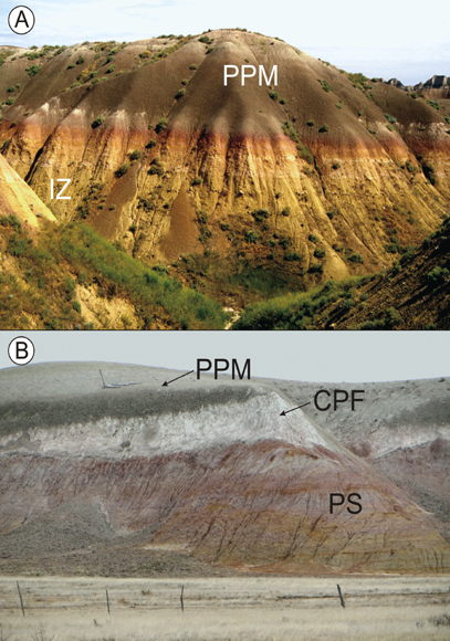
2. (A) Photograph of the Interior Zone (IZ) and Peanut Peak Member (PPM) of the Chadron Formation in Dillon Pass. (B) Photograph of the channel sandstone facies of the Chamberlain Pass Formation (CPF) underlain by Pierre Shale (PS), which has been modified by the Interior Zone of weathering and overlain by the Peanut Peak Member (PPM) of the Chadron Formation west of Interior, South Dakota. Photos by the authors.
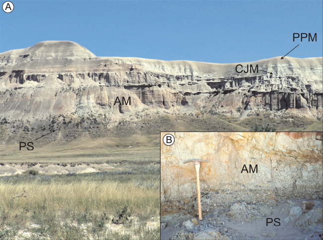
3. (A) Photograph of the Ahearn (AM), Crazy Johnson (CJM), and Peanut Peak (PPM) members of the Chadron Formation in Indian Creek northwest of Sheep Mountain Table. (B) Close-up of the unconformable contact between the Cretaceous Pierre Shale (PS) and the late Eocene Ahearn Member (AM) of the Chadron Formation. Pick for scale is 87 cm long. Photos by the authors.
4. Photo of complete White River Sequence, upper Conata Basin. HBm = Hay Butte marker; SPm = Saddle Pass marker; CPwl = Cedar Pass white layer. The rocks here dip 4 degrees to the southwest, away from the viewer. Photo by the authors.
5. Middle and upper Poleslide beds, the Rockyford Ash, and lower Sharps Formation at Cedar Butte. The view is to the west from the overlook at the southwest side of Sheep Mountain Table. Photo by the authors.
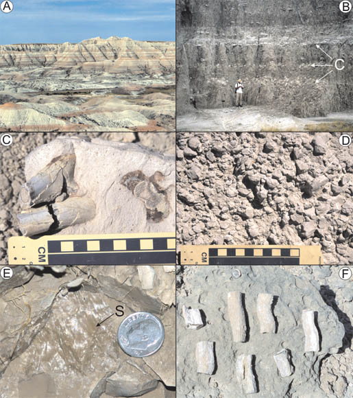
6. Photographs of various paleosol features in outcrop and hand sample. (A) Variegated striping is commonly seen with paleosols. (B) Horizons of soil-formed calcium carbonate (C) stand out in relief. Person for scale is 1.8 m tall. (C) Fossil bone locked inside of a calcium carbonate soil nodule. (D) Ped structures. (E) Slickensided surface (S). Coin for scale is 1.8 mm wide. (F) Permineralized roots. Coin for scale is 2 cm wide. Photos by the authors.
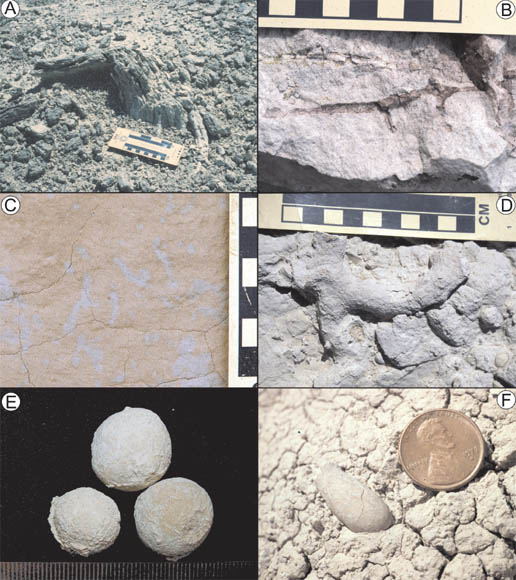
7. Additional paleosol features. (A) In situ silicified tree stump along an ancient stream channel. Note breakage suggesting water flow to the left. (B) Clay-filled root traces. Scale in centimeters. (C) Drab-haloed root traces. Scale in centimeters. (D) Burrow structure. (E) Dung balls. Scale in millimeters. (F) Bee larval cell. Coin is 1.8 mm wide. Photos by the authors.
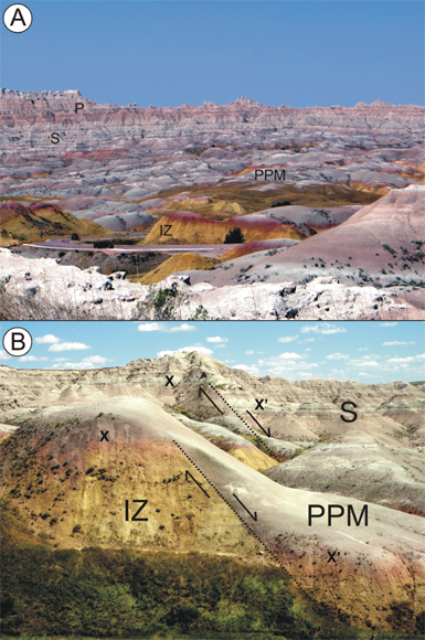
8. Photographs of Dillon Pass looking down the axis of the Sage Arch (A) with strata dipping down to the right and left from the center of the photograph, and the Dillon Pass Fault (B) showing directions of displacement and offset beds (X–X') on either side of the fault. IZ = Interior Zone (Plate 2); PPM = Peanut Peak Member of the Chadron Formation; S, P = Scenic and Poleslide members of the Brule Formation. Photos by the authors.
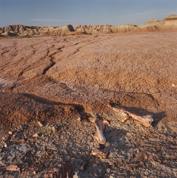
9. Photograph of the original discovery of fossil bones in Conata Basin that started the Big Pig Dig project. Note the greenish-colored layer from which the bones protrude. Photograph courtesy of Jim Carney.
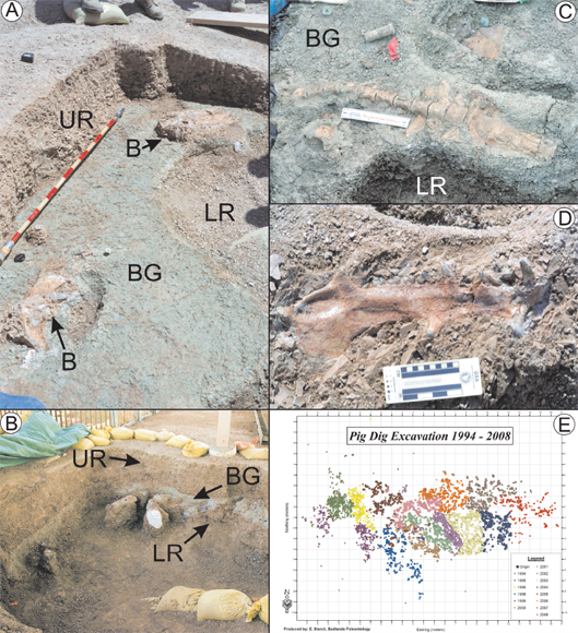
10. Photographs of the Big Pig Dig during excavation. (A) Several bones (B) resting within the bone-bearing green layer (BG). LR and UR = lower and upper red mudstone layers, respectively. Scale rod in decimeters. (B) View of the Big Pig Dig excavation in cross section. Various bones within the bone bearing green layer (BG), some of which have been covered with plaster for removal from the site. LR and UR = lower and upper red mudstone layers, respectively. Photograph courtesy of Diane Hargreaves.com. (C) Articulated backbone and pelvis within the bone-bearing green layer. (D) Lower jaw of an Archaeotherium. (E) Map of fossils recovered from the Big Pig Dig over a 14-year period. Photo (E) is courtesy of the National Park Service. Map is the property of the U.S. government. Photos (A), (C), and (D) are by the authors.
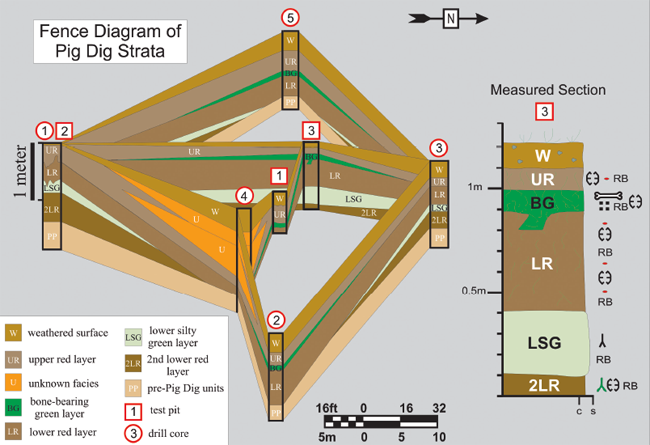
11. Fence diagram of units within the Big Pig Dig and a representative measured section. Modified from Terry (1996b). For a legend of paleosol symbols, see fig. 3.6.
12. Interpretive reconstruction of the Big Pig Dig by Robert Hynes. Property of the U.S. government.
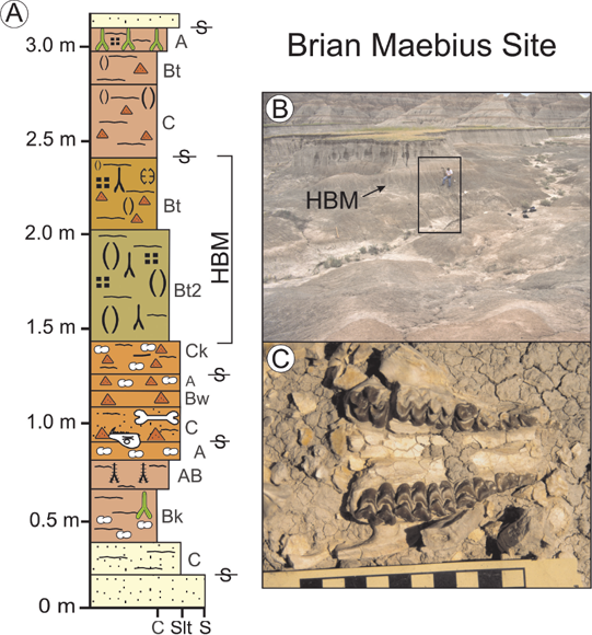
13. Measured section (A) through the Brian Maebius site, with photographs of the site (B) and fossil bone (C). The square in (B) denotes the location of the measured section (A). HBM = Hay Butte marker bed. For a legend of paleosol symbols, see fig. 3.6. Modified from Factor (2002).
14. Photographs of the White River Sequence across the region. Note that photographs are positioned in relative geologic order from bottom to top in each region. A–D, northwest Nebraska; E–F, southwest North Dakota; G–H, east-central Wyoming. (A) Outcrops near Toadstool Geologic Park showing the Interior Zone, which has modified the Cretaceous black Pierre Shale (PS) into a reddish-purple color, channel sandstone of the Chamberlain Pass Formation (CPF), and the Peanut Peak Member (PPM) of the Chadron Formation. (B) Exposures of the Big Cottonwood Creek Member (BCCM) of the Chadron Formation, the prominent volcanic ash of the Upper Purplish White layer (UPW), the Orella Member of the Brule Formation, and Toadstool Park Channel Complex (Tpcc). The Eocene–Oligocene boundary is several meters above the UPW. (C) The Orella (OM) and Whitney (WM) members of the Brule Formation. (D) The informal Brown Siltstone member of the Brule Formation just west of Fort Robinson State Park in northwest Nebraska. V = volcanic ash layers of the Nonpareil Ash Zone. (E) The Chalky Buttes (CB) and South Heart (SH) members of the Chadron Formation in the Little Badlands. (F) The South Heart Member (SH) of the Chadron Formation overlain by the Brule Formation (BF) in the Little Badlands. (G, H) Exposures of the undifferentiated late Eocene White River Formation at Flagstaff Rim southwest of Casper, Wyoming. V = volcanic ash. Note the rounded haystack morphology in (G), which is similar to the Peanut Peak Member, and the more cliff-forming strata in (H), which is similar to the Big Cottonwood Creek Member. Photos by the authors.
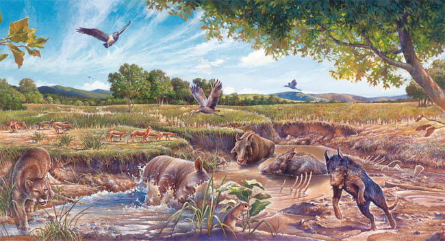
15. Eocene Chadron Formation. Mural by Laura Cunningham illustrating the White River Badlands over 37 Ma, during the deposition of the Chadron Formation. Fossil recreations depicted in the mural include the titanothere Megacerops and the oreodont Merycoidodon. Ancient forests and a warm subtropical environment, characteristic of the Late Eocene, are represented. Permission granted by Laura Cunningham and the Badlands Natural History Association.
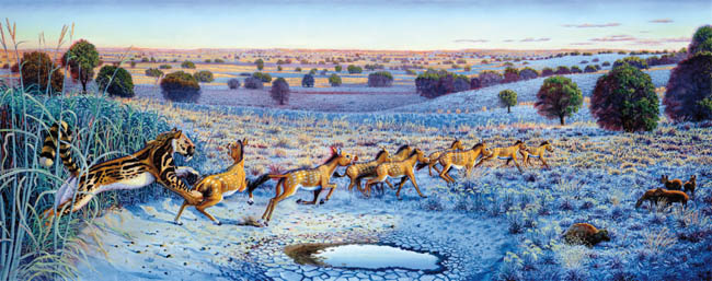
16. Oligocene Brule Formation. Mural by Laura Cunningham illustrating the White River Badlands about 33 Ma. Fossil recreations depicted in the mural include a saber-toothed cat from the family Nimravidae chasing three-toed horses known as Mesohippus. Open woodlands developing into an open grassland are represented in the mural. Permission granted by Laura Cunningham and the Badlands Natural History Association.