3.1. Primary factors affecting the development of a soil profile.
CLUES TO ANCIENT PALEOENVIRONMENTAL AND paleoclimatic conditions in the Badlands can be found in many sources, including fossils, sediments that make up the buttes and spires, and the enigmatic stripes of red, brown, and beige that cut across the Badlands. These razor-sharp lines of color are actually ancient soils (paleosols) representing former landscapes that have been buried and lithified (turned to rock). In order to utilize paleosols to reconstruct past climates and environments, we need a working knowledge of modern soils and the environmental conditions under which they form.
Soils are zones of physical, chemical, and biological activity at the surface of the Earth that modify geological materials into a more stable form. Physical weathering is the process by which geological materials are mechanically broken down into progressively smaller pieces. Chemical weathering is the interaction of geological materials with water and organic acids and alters the minerals that comprise the rock. These various forms of weathering and modification represent a quest for equilibrium between the forces of weathering and the stability of the geological material that is being weathered. As a soil develops, the downward movement of soil water and dissolved/suspended materials will create distinct accumulations (soil horizons) that reflect the particular physical, chemical, and biological processes regulated by five primary factors of soil formation: climate, organisms, relief, parent material, and time (CLORPT) (Jenny, 1941). Variations in these five factors have generated over 18,000 different soils in the United States alone (Soil Survey Staff, 1999).
In terms of soil formation, climate can be thought of as the predominant temperature and precipitation conditions for any given area. Is it hot or cold? Is it rainy most of the time, or is it dry like a desert? Warm, humid environments will promote faster rates of chemical weathering, whereas extremely cold climates promote physical weathering by freeze–thaw processes. Humid conditions favor the downward movement (eluviation) and accumulation (illuviation) of clays, whereas more arid conditions favor the accumulation of calcium carbonate by evaporation of soil water. The influence of organisms can be both physical and chemical in nature, and includes the smallest microbes to the largest animals as well as all varieties of plants. Relief is simply the shape of the landscape, otherwise known as topography. Changes in relief, if significant enough, will influence rates of soil erosion and stability, with areas of higher relief experiencing greater erosion. Parent material refers to the physical and chemical makeup of the geologic material that is being altered by soil formation. The last factor of soil formation is time. In the simplest sense, the more time that is available for weathering, the greater the degree of physical and chemical change that can be induced. Persistent deposition of new material or erosion of existing soil resets the time clock.
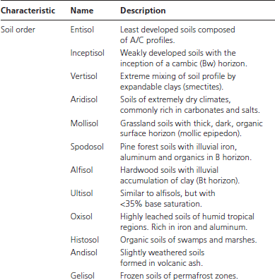
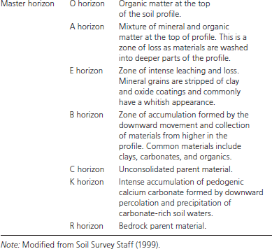
Soils are classified into 12 distinct orders (Soil Survey Staff, 1999). These soil orders are three-dimensional bodies of material that are composed of distinct combinations of horizons (Table 3.1). The types of horizons present in the soil are the direct result of CLORPT conditions. The first level of horizon classification is the master horizon (Table 3.1). O horizons are accumulations of purely organic matter at the land surface and can vary from a thin layer of leaf litter or a thick mat of marsh and swamp vegetation. A horizons are zones at the top of soil profiles (topsoil) that are defined by a mixture of geological materials and organic matter. B horizons are the primary zones of accumulation that form from the downward percolation of soil water and deposition of finer materials in pores and fractures, or the precipitation of minerals that were dissolved in the soil water. The C horizon represents unaltered parent material. These master horizons can be further classified on the basis of the presence of particular types of mineral and organic matter that accumulate within them (Table 3.1). Common diagnostic subsurface soil horizons include B horizons that are enriched in clay (argillic horizons, Bt) or calcium carbonate (calcic horizons, Bk). These horizons are stacked vertically and are referred to as a soil profile (Fig. 3.1).
Paleopedology is the study of fossilized soils (paleosols). This is a relatively new field within geology and has been steadily gaining in popularity over the past couple of decades. Today, the study of paleosols is used in a wide variety of geological investigations including paleoclimatology, paleoenvironmental analysis, geoarcheology, and vertebrate paleontology. The utility of paleopedology is grounded in the philosophy of modern soil genesis. The clues to ancient environmental and climatic conditions (paleo-CLORPT) that are preserved in the paleosol are extracted by a combination of field and laboratory techniques.
Early paleosol research in the Badlands was focused mainly on the intense zone of soil formation at the base of the White River Group within the Interior Zone (Plate 2; Ward, 1922; Wanless, 1923; Pettyjohn, 1966; Hickey, 1977). The first in-depth research on paleosols in Badlands National Park was conducted by Retallack (1983b) in which he recognized 87 superimposed paleosols representing 10 different types of soils within 143 m of section in the Pinnacles area (Fig. P.1). The most obvious clues to the presence of paleosols include horizonation, soil structure, and roots (Plates 6, 7). Horizonation is manifested as prominent brownish-red striping seen within outcrops. Particular horizons, such as accumulations of calcium carbonate, can form resistant ledges. The different colors are clues to ancient soil environmental conditions. Red and brown colors within paleosols are usually indicative of former well-drained soil conditions, allowing more oxygen to react with iron minerals, whereas green, black, and gray colors are commonly associated with former waterlogged and swampy conditions and less available oxygen. Depending on the type of paleosol that is preserved, individual paleosol profiles will contain horizons of differing colors, which is responsible for the barber pole striping so prevalent throughout the park (Plate 6).
Table 3.1. Soil orders, master soil horizons, and common subordinate indicators
Upon closer examination, smaller-scale features of paleosols can be detected and related to current soil forming conditions. In the Badlands, these smaller-scale features (nodules, concretions, and peds) are most commonly exposed by digging into the rock outcrop because the highly erosive nature of Badlands rock often obscures these features. Nodules and concretions are cemented bodies of particular types of minerals, most commonly calcium carbonate or iron oxide, which can sometimes be seen standing out in erosional relief in the outcrop (Plate 6). Soil scientists refer to these bodies as glaebules, and they form as the result of precipitation of minerals out of the soil water as it percolates through the soil profile. Glaebules of calcium carbonate are associated with drier soil conditions, and those composed of iron oxides are commonly associated with wetter soil conditions.
Peds are three-dimensional blocks of soil structure that form by the repetitive action of wetting and drying of a soil profile as a result of rain events, the burrowing action of organisms, and the downward penetration and branching of roots (Plate 6). Peds can be blocky, angular, crumb, granular, platy, columnar, or prismatic in shape. The different shapes depend on different types of soil conditions and position within a soil profile, and they represent the physical modification of the originally deposited sediments into distinct bodies. Crumb and granular peds are usually several millimeters in size, are generally rounded to slightly angular, and are commonly associated with dense accumulations of fine root hairs in the A horizon. Anyone who has tried to strip sod out of a yard is familiar with the little clumps of dirt that cling to the roots. These are the peds. Larger angular, blocky, and columnar/prismatic ped structures tend to be found deeper in soil profiles, commonly in the B horizon. Platy peds are most commonly associated with the original texture of sediments that were deposited by geological forces, such as flooding, and have not been altered to any great degree by soil formation. This type of ped structure is most commonly seen in the C horizon of soil profiles. Peds may sometimes display striated surfaces (slickensides) created by the expansion and contraction of soil materials as they repeatedly saturate and dry out as a result of rain events (Plate 6). Slickensides are common in soils that contain large proportions of smectite, a clay mineral that expands and contracts with moisture.
The most obvious clue to the presence of ancient soils in the Badlands should be fossilized plants and roots. The orientation, size, and mode of preservation of roots and plant material in a paleosol are important clues to ancient soil conditions. However, the soil conditions that were active during the formation of the Badlands did not favor the preservation of fossilized plant material. The most favorable environment for the preservation of plant material in the geologic record is in a marsh or swamp. The acidic nature of swamp and marsh waters helps to retard the decomposition of plant material. Over time, and with burial, thick accumulations of organic materials in swamps can be converted to coal. Under typical soil-forming conditions, water does not collect in the soil but drains through to the water table. This well-drained and aerated setting promotes the decay of plant material. This latter set of soil conditions was dominant during the accumulation of sediments in the Badlands.
Nevertheless, we do have evidence of ancient plant life in the Badlands. Within paleosols of the Badlands, plants, seeds, and roots are preserved as mineralized bodies or as clay or mineral infills of hollow spaces left by former roots that have since decayed, greenish ghosts formed by the decay of roots in low oxygen (anaerobic) conditions, or sheathes of calcium carbonate or iron oxide that precipitated around former roots (Plates 6, 7). Permineralization is the replacement of original plant materials on a microscopic scale, usually by quartz but by other minerals as well, and produces fossils most commonly referred to as petrified wood. This process produces extremely detailed preservation of original plant structures to such a degree that original cellular structures and tree rings can be preserved. Scientists can use this detailed preservation to classify plant remains into modern taxonomic groups, and they analyze variations in tree ring morphologies to interpret paleoclimatic conditions (Falcon-Lang, 2005).
Under well-drained and aerated soil conditions, which were the dominant conditions in the paleosols of the Badlands, plant material will decay rather quickly. Plant remains on the land surface will break down and become recycled. Roots will also decay and leave voids in the soil profile. These voids are commonly filled in with either clay or silt (a cast) and sometimes with minerals that grow in these voids upon burial in the geologic record (Plate 7). In other instances, original root material can persist with burial of the landscape and then be broken down by microbial decay of the root under oxygen-poor conditions. This process produces a greenish, ghostlike halo around the former position of the root (drab-haloed root trace), but the central void of the root will persist. This central zone can then be filled in by minerals (Plate 7).
Last, roots can self-fossilize while they are still alive. As roots absorb nutrients from the soil, they modify the chemistry of soil near the root. With periods of rainfall and infiltration, the acidity of the soil can change, as can the potential to release or fix iron. These repetitive episodes of wetting and drying, in conjunction with chemical changes in the root microenvironment, will promote the precipitation of calcium carbonate or iron oxides around the root body. This lithified mass, referred to as a rhizolith (root rock), can then be easily preserved upon burial in the geologic record. Carbonate rhizoliths are associated with drier climates, whereas iron oxide rhizoliths tend to be associated with soils that are subjected to periodic waterlogging.
In addition to the mode of preservation, the size and orientation of fossilized roots in paleosols of the Badlands provide insight into the general environment of soil formation and clues to overall paleoclimatic conditions. The size of fossil roots is directly related to the type of plant community that was present on an ancient land surface. Large roots several centimeters across represent trees, whereas hairline root structures indicate former grasslands. Roots that penetrate downward represent well-drained soil conditions, whereas roots that are more horizontal suggest waterlogged or shallow water table conditions. Roots and plants preserved as carbonized traces or coal, which have yet to be identified in the Badlands, represent former waterlogged, marshy, and swampy conditions. Clay- and mineral-infilled root voids, drab-haloed root traces, and rhizoliths represent soils that formed under well-drained conditions.
Burrows of small animals and insects are also common features within soils, which raises the question of how one would tell them apart in the geologic record. In brief, both can branch in a downward direction, but roots will taper as they branch whereas burrows will remain constant in size (Plate 7). However, similar to roots, burrows can be an indicator of soil conditions. Deep, penetrating burrows will be found in soils that are well drained. Burrowing animals that make their dens below ground will not dig deeper than the water table. Common insect burrows in the strata of the Badlands include those made by dung-ball beetles and subterranean bees (Plate 7). Dens or burrows of mammals have yet to be identified in the Big Badlands.
As we look at the strata of the Badlands, we can recognize a vertical change in the appearance of various rock formations (Plate 4). The base of the Badlands is composed of brightly colored orange and red strata, which are in turn covered by greenish-gray rock that weathers into haystack shapes, and finally beige and light brown cliff- and ridge-forming strata defined by vibrant stripes of color that cut across the Badlands. This vertical change in color and resistance to erosion is a function of the types of ancient environments that were responsible for the deposition of sediments that formed the Badlands, the types of sediments that were deposited, and the soil-forming environments that modified the sediments after deposition.
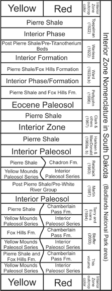
After the retreat of the Western Interior Seaway approximately 68 Ma, this entire region, from North Dakota to Colorado, was subjected to 30 million years of intense soil formation and erosion (Pettyjohn, 1966). Within Badlands National Park and the surrounding region, this episode of intense soil formation is represented as the bright yellow, purple, and red interval that underlies the White River Group Badlands and is referred to by various names, including the Interior Zone, Interior Paleosol, or Interior Formation, for exposures of this interval in and around the town of Interior, South Dakota (Plate 2; Fig. 3.2). Within Badlands National Park, this interval is best exposed in Dillon Pass and along the Sage Creek Rim Road (Fig. P.1).
From a distance, this brightly colored interval appears as a gradual transition from bright reddish rock at its top to progressively yellow strata farther down (Plate 2). In actuality, this brightly colored zone represents several different episodes of ancient soil formation that modified distinctly different sedimentary units before in turn being buried by the next depositional event (Retallack, 1983b). The lowermost of these distinct episodes of pedogenesis is referred to as the Yellow Mounds Paleosol Series and is named for exposures in Dillon Pass (Retallack, 1983b). The term series is used by modern soil scientists to describe a discrete package of soil with particular physical and chemical characteristics that can be compared to other nearby soils across a landscape. The Yellow Mounds Paleosol Series modified the underlying Cretaceous marine Fox Hills Formation and underlying Pierre Shale, which changed the Fox Hills Formation into a more yellowish-orange color with intervals of red and purple, and the Pierre Shale from its original dark grayish-black to bright yellow and orange (Plates 1, 2; Fig. 3.2). Within Dillon Pass, these colors extend and lessen downward for tens of meters, and in the lowest part of some stream drainages, the original black color of the Pierre Shale can be seen.
According to Retallack (1983b), the Yellow Mounds Paleosol Series represents an intense period of ancient soil formation under humid subtropical conditions, similar to what would be found today in Georgia or South Carolina. Within modern soil classifications (Soil Survey Staff, 1999), the Yellow Mounds paleosol represents an ultisol, a soil that has accumulated clays in its B horizon (A–Bt–C) and had a large proportion of its unstable, easily weathered minerals removed to leave behind only the most resistant minerals. Roots preserved within the Yellow Mounds Paleosol Series are suggestive of forested vegetation. With increasing depth into the Yellow Mounds Paleosol Series, the original unstable mineralogies of the Fox Hills Formation and Pierre Shale survived pedogenesis as the strength of soil formation waned.
Approximately 37 Ma, during the late Eocene, the rivers that had been flowing across the forested strata of the Pierre Shale and Fox Hills Formation began to deposit sediments. These sediments, referred to as the Chamberlain Pass Formation (Evans and Terry, 1994), are represented by the bright red stripe of mudstone just above the Yellow Mounds Paleosol Series in Dillon Pass and occasional bright white lenses of sandstone, which are seen more frequently to the south near the town of Interior (Plate 2) and to the north near the Minuteman Missile Site (Fig. P.1). Before the recognition of the Chamberlain Pass Formation, Retallack (1983b) recognized that this bright red stripe of mudstone capping the Yellow Mounds Paleosol Series was modified by a separate episode of ancient soil formation and that it not only modified the mudstone but also penetrated through this layer to partially overprint the underlying Yellow Mounds Paleosol Series. Retallack (1983b) named this distinct period of soil formation the Interior Paleosol Series (Fig. 3.2). According to Retallack (1983b), the Interior Paleosol Series represents pedogenesis in conditions similar to the underlying Yellow Mounds Paleosol Series. Within soil taxonomy, the Interior Paleosol Series is similar to modern alfisols, soils that form under forests and accumulate clays in their B horizons (A–Bt–C), but not to the extent of weathering and soil formation of an ultisol.
Lateral tracing of the Interior Paleosol Series reveals that paleosols next (proximal) to ancient stream channels of the Chamberlain Pass Formation formed under different environmental conditions. These proximal paleosols show evidence of hydromorphy, the effect of rising and falling water tables. As the position of the water table fluctuates, the chemistry of the soil will change from oxidizing to reducing conditions as the soil profile experiences alternating wet and dry conditions. Over time, this results in the buildup of iron oxide masses (glaebules) and discolors the soil profile into a mottled collection of reddish, greenish, and gray colors. Terry and Evans (1994) classified these particular soils as the Weta Paleosol Series for exposures east of Badlands National Park near the town of Weta, just southwest of Kadoka, South Dakota. Taken together, the Interior and Weta paleosol series represent an ancient soil catena, a laterally linked association of distinct soil types across a landscape.
After deposition of the Chamberlain Pass Formation, the rivers flowing across this region began to cut down through the strata of the Chamberlain Pass and Fox Hills formations, through the Yellow Mounds Paleosol Series, and eventually stopped downcutting after reaching unaltered Pierre Shale. This episode of river downcutting, which formed the Red River Valley of Clark, Beerbower, and Kietzke (1967), increased the percolation and drainage of precipitation through the paleosols of the Chamberlain Pass Formation and created highly weathered soils. The sediments in the former river channels of the Chamberlain Pass Formation, which were abandoned when the downcutting began, only preserve the most resistant of minerals, such as quartz (Terry and Evans, 1994), while the other minerals in these former stream channels were converted to kaolin clay by hydrolysis, which explains their blazing white color (Plate 2). The soils of the Interior Paleosol Series were so well drained and stable when the Red River Paleovalley was cut that the majority of mammal bones were destroyed before fossilization, a situation atypical for the majority of deposits in the Badlands. Fossils that have been recovered from the channel sandstones of the Chamberlain Pass Formation suggest a Chadronian age, and possibly as old as the Duchesnean (Clark, Beerbower, and Kietzke, 1967; LaGarry, LaGarry, and Terry, 1996; Terry, 1998).
3.2. History of nomenclature for the Interior Zone.
The sediments that filled the valleys that cut through the Chamberlain Pass Formation were deposited by ancient rivers to produce the Chadron Formation. The Chadron Formation is represented by the Peanut Peak Member across the majority of the region, but within one of the paleovalleys to the west (Plate 3), the Ahearn, Crazy Johnson, and Peanut Peak members are all present (Clark, Beerbower, and Kietzke, 1967; Terry, 1998). As with rivers today, periodic flooding buried ancient floodplain soils, and the paleovalleys were eventually filled, preserving numerous paleosols and their associated vertebrate fossils.
According to Retallack (1983b), the Chadron Formation (Peanut Peak Member) in the Dillon Pass area is dominated by soils similar to modern Alfisols (forest soils: A–Bt–C horizons) that would have formed under subhumid to humid, warm conditions (Plates 2, 4). Retallack (1983b) named these the Gleska Paleosol Series and recognized that on occasion these soils contained concentrations of pedogenic carbonate lower down in their horizons (A–Btk–Ck), which collected under drier soil forming conditions. To the west, within the paleovalleys filled by the Chadron Formation, permineralized roots from the Ahearn Member are several centimeters across and indicate forested vegetation (Plate 6; Terry, 1998).
The overlying Brule Formation represents a change to different soil-forming conditions than those that occurred during the deposition of the Chadron Formation. This change in paleo-CLORPT conditions manifests as a change in the types of sediments that were deposited as well as the types of paleosols that formed. The boundary between the Chadron and Brule formations straddles the transition from the Eocene to Oligocene and represents the local response to a significant worldwide climatic shift from warm and humid to cooler and drier climates: the Hothouse to Icehouse Transition.
Retallack (1983b) recognized five distinct types of paleosols over 38 m within the Scenic Member in the Pinnacles area (Fig. P.1). In stratigraphic order, these include the Conata, Gleska, Zisa, Ohaka, and Ogi soils. The profile identifications initially proposed by Retallack (1983b) have become outdated; they now fall within new categories in USDA soil taxonomy (Soil Survey Staff, 1999). The soils are described here as they were originally interpreted by Retallack (1983b), and reference to the old versus new classifications is made as needed.
The Conata Series represents soils that formed away from active river channels on terraces or floodplains. They are inceptisols (A–B–C profiles) and are characterized by clay enrichment in the B horizon (BE), moderately weathered volcanic ash shards and feldspars, medium-size greenish root traces, and an overall calcareous nature. The Gleska Series is still present in the Scenic Member, indicating that forested conditions were still present on these landscapes. The Zisa Series represents weakly developed soils that formed along active river channels, possibly within swales and on proximal levee deposits. They are entisols (A–C profiles), which are characterized by little development and small rootlets. The Ohaka Series represents weakly developed, possibly waterlogged soils, which formed along the edge of sloping floodplains or active rivers, or on stream-side bars. They are entisols in modern soil taxonomy (A–C profiles) on the basis of the descriptions of Retallack (1983b), although he lists them as inceptisols. They are characterized by surficial concentration of rootlets and reworked soil material from nearby Gleska Series soils. The Ogi Series represents thin, weakly developed, possibly waterlogged soils that formed in interstream depressions. They are also entisols by modern classification standards (A–C profiles), instead of inceptisols as reported by Retallack (1983b), and are characterized by poor development, colors suggestive of poor drainage, and roots ranging from small to large in size.
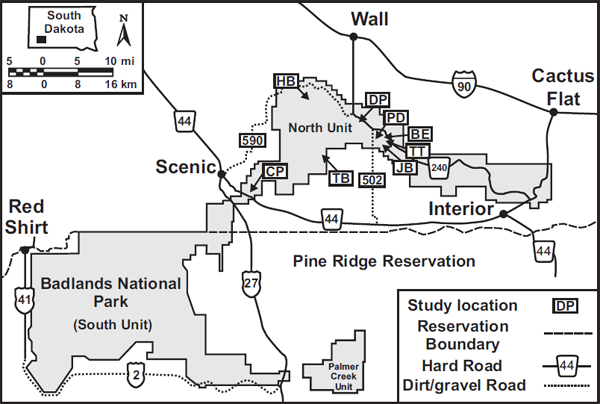
Additional research involving paleosols of the Scenic Member includes Terry (1996a, 1996b), who used paleopedology to interpret the genesis of the Big Pig Dig, an extremely concentrated Orellan vertebrate assemblage bone bed near the Conata Picnic Ground. Other, more recent researchers have used paleopedology to interpret vertebrate taphonomy within the lower Scenic Member (Factor, 2002; Factor and Terry, 2002; Terry in Benton et al., 2007), including McCoy (2002), who studied the paleopedology of the Hay Butte marker bed of Evanoff (in Benton et al., 2007), and Metzger, Terry, and Grandstaff (2004), who evaluated the effects of paleosols on the process of fossilization. This combination of research on the paleosols of the Scenic Member across the Badlands has revealed a pattern in which the variety of ancient soil types appears to be responding to changes in the environmental conditions of soil formation within the Scenic Member (Fig. 3.3). The majority of these observations fall within the lower part of the Scenic Member, below and within the Hay Butte marker of Evanoff (in Benton et al., 2007).
3.3. Map of paleosol study locations of within the Scenic Member. BE = Bessie Site; CP = Chamberlain Pass; DP = Dillon Pass; HB = Hay Butte; JB = Jerry’s Bone bed; PD = Big Pig Dig; TB = Tyree Basin; TT = Tilted Turtle.
The paleosols of the Scenic Member are generally weakly to moderately developed (entisols and inceptisols) and were strongly influenced by their position on the ancient landscape during deposition of the Scenic Member. Those paleosols closer to ancient streams were weaker (entisols) as a result of the more common episodes of overbank flooding and burial of the ancient landscape, and they sometimes show evidence of waterlogging (Fig. 3.4). Positions along the landscape further away from active rivers would have benefited from longer periods of time between flooding events and thus could have developed into better formed soils (inceptisols). Fossil roots within the Scenic Member are smaller overall in comparison to those preserved in the underlying Chadron Formation, 0.5 to 1 cm diameter, and suggest more open landscapes instead of forested ecosystems. Direct preservation of plant material is extremely rare in the Scenic Member, but a few locations in the park preserve silicified trees, still in life position (Plate 7).
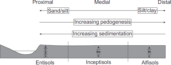
To the west near Scenic, South Dakota, paleosols of the basal Scenic Member are most commonly weakly developed, and vertebrate fossil preservation is excellent throughout the area (Figs. 3.3, 3.5, 3.6). Along with preservation within paleosol profiles, fossil bone is also preserved as bed load, the coarse material found at the bottom of river channels. The degree of abrasion of the bone varies from rounded bone chips to complete limb bones. From a facies perspective, this area represents a proximal floodplain position characterized by repetitive flooding events, now preserved as individual upward-fining packages of siltstone and mudstone, which buried former land surfaces and promoted fossil preservation. From a paleopedological perspective, this region is composed of a series of stacked entisols (A–C profiles) and inceptisols (A–Bw–C profiles) heavily influenced by river processes and minimal pedogenic modification (Figs. 3.4, 3.5). The individual profiles represent pedogenic modification of the discrete upward-fining overbank flood deposits. The fossils preserved with these deposits likely represent a combination of attritional accumulation on the landscape and animals caught up in individual flooding events. Commonly the fossils are lying directly on top of a former land surface (within an overlying C horizon), as indicated by drab-haloed root traces directly beneath the fossils (Plate 7; Fig. 3.5). These paleosols are most similar to the Zisa and Conata series of Retallack (1983b).
3.4. Model of soil formation on a floodplain from proximal to distal.
In the Dillon Pass area of the park (Fig. 3.3), the paleosols of the Lower Scenic Member are dominated by a combination of simplistic A–C profiles (entisols) and slightly more developed A–Bw–C profiles (inceptisols). The Dillon Pass area is situated on the crest and flanks of the Sage Arch. Because of syndepositional uplift during deposition of the White River Group, individual stratigraphic units thin across the top of the arch and create a condensed section in which larger amounts of geologic time are represented by the thinner strata and associated paleosols compared to areas off the arch that experienced greater rates of sedimentation. The paleosols in this area were also influenced by the infilling of paleotopography on the underlying Chadron Formation. Those soils that formed in lower parts of this aggrading paleotopography experienced greater influence from fluctuations on the ancient water table compared to others that formed on strata deposited after the majority of the paleotopography had been filled. Particular examples of paleosols within Dillon Pass serve to demonstrate this degree of pedogenic variability.
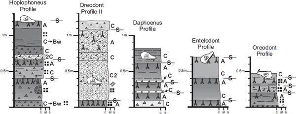
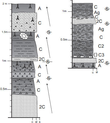
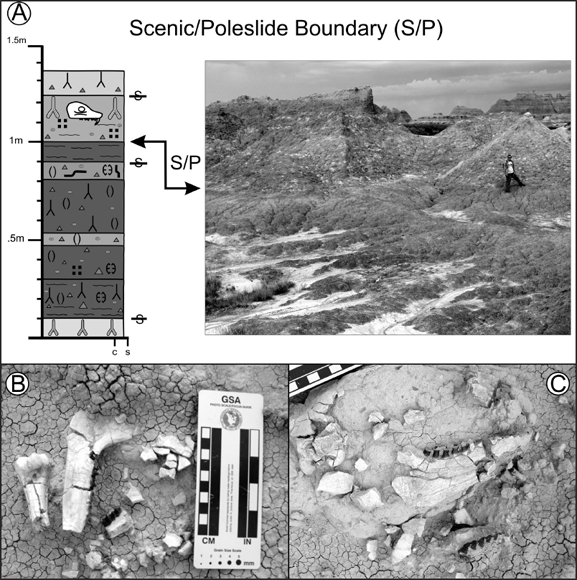
Jerry’s Bone Bed profile is located southeast of the Conata Picnic Grounds (Fig. 3.3). This site is noted for a large concentration of disarticulated bones that are commonly stained orange-red (Fig. 3.7). From a facies perspective, this site represents a proximal floodplain position dominated by interbedded siltstones and mudstones. From a paleopedological perspective, this site is composed of a series of stacked A–C profiles (entisols) with minimal pedogenesis and a strong influence from fluctuating water tables. The individual profiles are upward-fining fluvial packages that have been overprinted by pedogenesis. Their proximal position to a former stream channel creates a condition in which pedogenesis is commonly interrupted by overbank deposition. The bones associated with these deposits were transported as bed load. Although dominated by disarticulated bones, several complete turtle fossils are found lateral to these paleosols. Paleosols in this profile are most similar to the Zisa Series of Retallack (1983b).
The Tilted Turtle profile is located approximately 0.5 km northeast of the Conata Picnic Grounds (Fig. 3.3). This site is noted for the odd tilted orientation of an associated turtle (tortoise) carapace (Fig. 3.8). From a facies perspective, this site represents a proximal to medial floodplain position and is composed of an upward-fining sequence of overbank sediments, possibly a crevasse splay, given the siltstone at the base and the presence of claystone breccia that also fines upward. From a paleopedological perspective, this site is an A–Bw–C profile (inceptisol) that overlies an earlier soil and is in turn capped by an overlying profile. The proximal to medial floodplain position creates a condition in which pedogenesis was allowed sufficient time to begin modification of the profile to include a Bw (cambic) horizon (Fig. 3.4). The tortoise shell is in good condition and is buried within the uppermost horizon of the profile. On the basis of the presence of drab-haloed root traces, this was a stable land surface for a brief period of time before additional sediments accumulated and buried the profile. Vertical accretion was likely episodic given the presence of relict bedding and root traces in the uppermost A horizon. The entire profile was then removed out of the range of active pedogenesis by influx and burial of new sediments (uppermost C horizon). This paleosol is most similar to the Conata Series of Retallack (1983b).
3.5. Soils of the Scenic Member in Chamberlain Pass. See Fig. 3.6 for explanation of symbols.
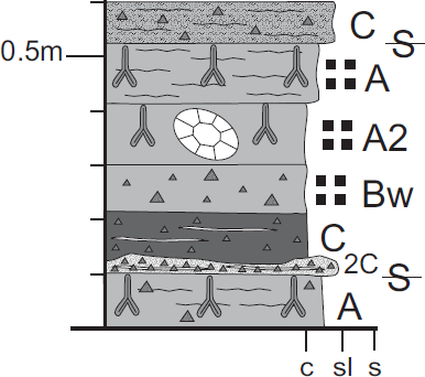
The Bessie Site profile is located approximately 0.5 km north-northeast of the Conata Picnic Ground (Fig. 3.3). It is noteworthy for the articulated skull and mandibles of the oreodont, Merycoidodon, in the middle of the profile (Fig. 3.9). From a facies perspective, this profile is proximal, but not immediately next to, a former channel. From a paleopedological perspective, this is a simplistic A–C (entisol) soil that appears to have been truncated by erosion. The base of the profile is a claystone breccia-rich C horizon overlying a former A horizon of an underlying profile marked by drab-haloed root traces. This C horizon is partially eroded and capped by another claystone breccia-rich C horizon. Drab-haloed root traces penetrate this horizon from above, although no well-defined A horizon is present. This may be due to frequent episodes of vertical accretion. Accretion eventually outpaced pedogenesis and buried the profile. The oreodont skull and mandibles are associated with the weak zone of drab-haloed root traces. The bones are in excellent condition except for the presence of gnaw marks on the sagittal crest area of the skull. This suggests that the skull was exposed briefly on the land surface before burial, but not long enough to incur damage from weathering or disarticulation by scavengers. The paleosols in this profile are most similar to the Zisa Series of Retallack (1983b).
Although the majority of the paleosols and ancient river deposits suggest that the landscapes of the Lower Scenic Member predominantly supported weakly to moderately developed soils because of frequent flooding, one paleosol profile within the Scenic Member tells a different story. As we look at the various stripes of paleosol profiles that stretch across the buttes of the Badlands, we can occasionally find one that can be traced over great distances. Within the Scenic Member, one particular paleosol profile forms a prominent, regionally extensive marker (Evanoff in Benton et al., 2007).
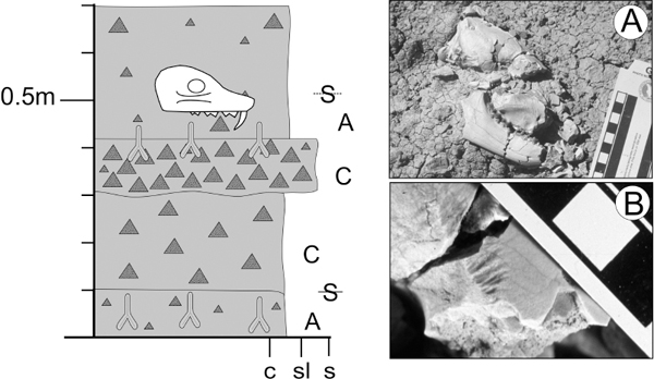
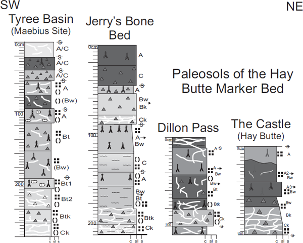
The Hay Butte marker bed is a paleosol profile that formed across an ancient landscape of the Scenic Member (Plate 4; Fig. 3.10), but depending on where you look, the physical nature of the Hay Butte marker bed changes (McCoy, 2002). In Tyree Basin (Fig. 3.3), the Hay Butte marker has an extremely enriched horizon of percolated clay in the subsoil (argillic horizon; Bt). Clay accumulated to such a degree that it created films of clay (argillans) up to 0.5 cm thick around peds. Most argillans are no more than a millimeter thick. Roots within the Hay Butte marker bed are quite small and suggest little to no influence by trees (similar to grassland soils of today: mollisols), and the sediments that make up the uppermost part of the Hay Butte marker bed are fine grained and massive, suggesting input via windblown (eolian) transport of silt. In Dillon Pass and at Hay Butte proper (Fig. 3.3), this interval is marked by thinner, less developed inceptisols.
3.6. Legend of paleosol symbols used throughout Chapter 3.
3.7. Jerry’s Bone Bed paleosol profiles in the Scenic Member. These profiles are lateral to each other and demonstrate changing hydromorphic conditions. See Fig. 3.6 for explanation of symbols.
The two most likely explanations for the regional variability across this ancient landscape (paleocatena) include tectonics and sedimentation. Whereas most paleosols of the Scenic Member are responding to their proximity to an ancient river and the effects of frequent versus infrequent flooding events, the Hay Butte marker bed represents a response to larger-scale tectonic forces. Dillon Pass rests on the Sage Arch, an uplifted area that acted as a highland during the formation of the Hay Butte marker. This relative difference in elevation from the “upland” of the Sage Arch to the “lowland” of the Tyree Basin area is reflected in the weaker soils on the flank and crest of the Sage Arch and the extremely well-developed paleosols of the Hay Butte marker in Tyree Basin (McCoy, 2002). The episode of pedogenesis that modified the Hay Butte marker was also influenced by a period of lower-than-normal sedimentation across the region that would have allowed the Hay Butte marker paleosols to develop into more mature profiles compared to those in other strata of the Scenic Member. The Hay Butte marker bed is capped by typical fluvial sedimentation found elsewhere in the Scenic Member, but the nature of sedimentation higher up in the Scenic Member suggests a greater influence of eolian sedimentation over time.
3.8. Titled Turtle Profile in the Scenic Member. See Fig. 3.6 for explanation of symbols.
The transition to the overlying Poleslide Member of the Brule Formation is marked by several distinctive features, and the paleosols within it record the influence of a combination of fluvial, lacustrine, and eolian environments, each of which is dominant at different times throughout the deposition of this unit. The Poleslide Member is distinguished from the underlying Scenic Member by an increase in the amount of silt. This translates to a relatively greater resistance to erosion for the Poleslide Member, which is why this unit erodes into vertical cliffs (Plate 4). The other characteristic that coincidentally marks the boundary between the Scenic and Poleslide members is a silver-beige layer of volcanic ash, referred to as the Cactus Flat bentonite bed (more appropriately a marker bed) by Stinchcomb (2007), which extends across the northern part of the park.
3.9. Bessie Profile in the Scenic Member, in situ skull (A), and ancient rodent gnaw marks along the top of the skull (B). See Fig. 3.6 for explanation of symbols. Photos by the authors.
Although there are stripes of color that represent paleosols that formed on landscapes of the Poleslide Member, some soils are different than those that formed earlier in the history of the Badlands and result in a more uniform color for the Poleslide Member (Plate 4). Retallack (1983b) recognized five distinct types of paleosols within 46 m of the Poleslide Member in the Pinnacles area of the park (Fig. P.1), two of which appear for the first time. In stratigraphic order, these include the Ogi, Wisange, Zisa, Gleska, and Pinnacles soils.
The Wisange Series represents weakly to moderately developed soils. They are inceptisols (A–B–C profiles) that formed on proximal floodplain positions, similar to the Ogi Series, but on slightly more elevated landscapes. They have slightly clay-enriched B horizons and roots ranging from small to large in size. The Pinnacles Series represents calcareous, ash-rich soils dominated by fine roots. They are aridisols with simplistic A–C horizonation that formed under dry climates on distal floodplain settings. The soils and ancient environments described herein for the Poleslide Member are based on observations concentrated around the Door and Window trailheads, at Cedar Pass, and at Norbeck Pass (Fig. P.1).
Pedogenesis associated with the Scenic/Poleslide contact is unique within the section. This is a moderately to well-developed, well-drained, and oxidized soil (Fig. 3.11). There are distinct soil horizons, root traces, ped structures, argillans, and soil fabric. Roots are abundant as branching, drab-haloed and clay-filled root traces up to 0.5 cm in diameter. The small root size suggests shrublike vegetation. This paleosol is similar to udalfs (humid climate alfisols; A–Bt–C profiles). According to Retallack (1983b), paleosols of the Scenic/Poleslide Boundary are classified as the Ogi Series (weak A–C profiles, occasionally with clay and carbonate accumulations) in the Pinnacles area. This paleosol is not an Ogi equivalent. The dissimilarity may be due in part to the revision of the boundary between the Scenic and Poleslide members by Evanoff (in Benton et al., 2009). This paleosol is most similar to the Gleska Series of Retallack (1983b), which is found near the revised lithologic boundary. The base of the Poleslide Member is a platy, greenish, muddy siltstone layer with prominent relict bedding. This greenish siltstone is also rich in vertebrate fossils, ranging from isolated bones to articulated skeletons.
3.10. Paleosol profiles within the Hay Butte marker bed of the Scenic Member across the North Unit of Badlands National Park. See Fig. 3.3 for location of individual profiles and Plate 4 for outcrop picture. Modified from McCoy (2002). See Fig. 3.6 for explanation of symbols.
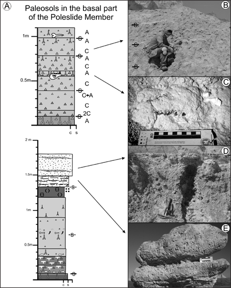
Basal fluvial soils The bottom 5 m of the Poleslide Member are characterized by a repetitive pattern of pedogenically modified nodular silty layers that are capped by finer muds and clays (Fig. 3.12). Small roots are common at the top of these individual 30 to 50 cm thick packages, which in turn are covered by the next silt to clay package. These soils are weakly developed entisols (A–C and A–Ck profiles; k = carbonate enriched) with little evidence of pedogenesis other than drab-haloed and clay-filled root traces, and occasional carbonate nodules. Fossils within these soils occur on top of upward-fining sequences as flat-lying, isolated bones, commonly within carbonate nodules. The orientation of the bones, their association with weakly developed soils, the overall upward-fining nature of these individual packages of sediment, and the concentration of roots at the tops of these packages suggest a scenario in which bones lying on ancient landscape were covered by flooding events. These soils are most similar to the Ogi Series of Retallack (1983b).
Lacustrine influenced soils Lacustrine environments are dominant in the middle of the Poleslide Member in the Door and Window area. Lateral to this ancient lake, the paleosols show evidence of groundwater influence as mottles, but also zones of intense cementation by calcium carbonate. These zones of intense carbonate cementation manifest themselves as resistant ledges in outcrop and contain well-preserved traces of former soil ecosystems, including fossilized dung balls, larval chambers of subterranean bees, burrows, and calcified root traces (Plate 7). On occasion, vertebrate fossils can be found within or directly on these resistant ledges, suggesting that they formed very near to, if not at, the ancient land surface.
3.11. Paleosol profile and outcrop photograph across the Scenic/Poleslide Member contact near the Fossil Exhibit Trail (A). Person for scale is 1.8 m tall. (B), (C) In situ fossils associated with the boundary. See Fig. 3.6 for explanation of symbols. Photos by the authors.
The characteristics of these paleosols lateral to the ancient carbonate lake suggest a combination of wetter soils proximal to the lake and drier soils farther away (Mintz, 2007; Mintz, Terry, and Stinchcomb, 2007). The preservation of burrows and dung balls suggests soil conditions that were well drained because these features would not have been formed beneath the water table. The dense concentration of roots, dung balls, burrows, and larval chambers, along with a greater-than-normal background accumulation of vertebrate fossils, suggests that these were stable landscapes with little to no sedimentation. On the basis of root diameters (most 5 mm or less, with infrequent traces up to 1 cm), landscapes at this period of time were open savanna-type environments with few to no trees. Within modern soil taxonomy, paleosols on these ancient landscapes would be similar to grassland soils of the Great Plains (mollisols) to those found in drier parts of the western United States (aridisols).
3.12. Paleosols from the basal part of the Poleslide Member. (A) Measured sections. (B) Stacked paleosols in outcrop. (C) Inverted skull on ancient land surface. (D) Fluvial sandstone capping paleosol profile. (E) Close-up of fluvial sandstone showing voids formed by ancient roots. See Fig. 3.6 for explanation of symbols. Photos by the authors.
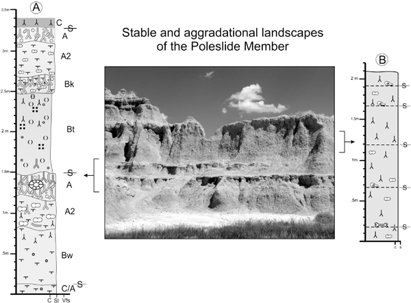
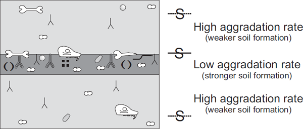
3.13. Photograph of stable (A) and aggradational (B) landscapes and associated paleosol characteristics in the Poleslide Member at Door and Window Overlook. Note differences in erosional relief. See Fig. 3.6 for explanation of symbols. Photo by the authors.
Eolian-dominated soils Landscapes dominated by eolian processes were present before and after this period of lacustrine-dominated sedimentation. The rate of eolian influx was not steady, resulting in dramatically different soil types (Fig. 3.13). During periods of relatively faster eolian influx, landscapes were progressively buried as soils kept pace with deposition, which created zones of massive, siltstone-dominated intervals. Pedogenic features, such as roots, are scattered throughout these zones of massive siltstone, and distinct paleosol horizons are absent (Fig. 3.14). Fossils appear to float within these massive intervals without reference to defined land surfaces. The lack of defined horizons and random distribution of fossils throughout these massive siltstones suggests cumulic soil-forming conditions during which the landscape slowly aggraded by the addition of eolian materials. New material was incorporated into the developing soil, creating overly thickened soil profiles without defined horizons. These soils are most similar to the Pinnacles Series of Retallack (1983b). Conversely, periods of low influx of eolian sediments resulted in stable landscapes that allowed for concentrated accumulation of pedogenic features. These stable soils manifest as resistant grayish-white layers that contain a high concentration of hairline carbonate rhizoliths, dung balls, burrows, and sweat bee pupae (Plate 7; Figs. 3.13, 3.14). These resistant horizons grade downward to relatively less carbonate-rich zones. Vertebrate fossils are concentrated within and at the top of these resistant layers (Benton et al., 2009). The presence of calcium carbonate at such a shallow depth and the prominence of a thick mat of carbonate rhizolith root traces containing dung balls and sweat bee pupae suggest that these soils formed under arid conditions. There is no direct match with the paleosols of Retallack (1983b). They are most similar to the Wisange and Pinnacles series, although the degree of carbonate accumulation and overall profile development within the Wisange and Pinnacles series is less.
3.14. Model of stable versus aggradational paleosol phases in the Poleslide Member. Note higher concentration of paleosol features during stable phases. See Fig. 3.6 for explanation of symbols.
Paleosols of the White River Group provide a unique perspective on paleoclimatic change across this region from the late Eocene into the Oligocene. On the basis of paleosols alone, the paleoclimates in this region of North America appear to have undergone a progressive drying trend that changed the landscape from a predominately forested habitat in the late Eocene Chadron Formation to open savannas of the Oligocene Brule Formation. These changes are recorded in the types of paleosols that formed. In particular, the most obvious clues to paleoclimatic change include a change from soil horizons enriched in translocated clays in the Chadron Formation to progressive enrichment of calcium carbonate in soils of the Brule Formation, and the change in the overall size of fossil roots from forested vegetation in the Chadron Formation to more open, prairielike vegetation in the Brule Formation. Across individual landscapes, the dynamics of sedimentation and relative degrees of time available to form these ancient soils resulted in weaker soils near ancient rivers, or during periods of rapid influx and aggradation of eolian materials. Geographic locations farther away from active river channels, or landscapes unaffected by rapid eolian influx, were able to generate better-developed soils. Some of the most distinct marker beds in these rock units, such as the Hay Butte marker, are the direct result of distinctive periods of pedogenic modification along a defined landscape. Although the data preserved within the paleosols suggest an overall change to progressively open landscapes from the late Eocene to the early Oligocene within the White River Group, the cause for this shift could have been paleoclimatic change, or possibly an increase in the rate of sediment delivery to this region. As with any research, more data are required in order to completely understand the dynamics of paleoecosystem change within these strata.
The other important consideration regarding the paleosols of the White River Group is the role they played in creating the lithologic units that we see today. The sediments that accumulated to form the White River Group were modified by pedogenesis before their eventual burial and preservation. The warm, humid conditions of the late Eocene resulted in soils enriched in the smectite clay formed by the breakdown of the large amounts of volcanic materials present across this region. By the time the Brule Formation was being deposited, the rate of weathering of volcanic material lessened, resulting in the preservation of original ash materials. This in turn created siltier sedimentary deposits with less smectite. These differences in ancient weathering during the deposition of the Chadron and Brule formations manifest today as the low, rounded, smectite-enriched hills of the Chadron Formation versus the silty cliff- and spire-forming Brule Formation (Plate 4).