8
Planning Lake Basins
ONCE CONSIDERED A limitless resource in the United States, water has in recent decades become an important policy concern in most regions of the country. The era of extensive water development based on federal subsidies for the construction of large dams, aqueducts, and intrabasin water transfers has ended. Disputes over the allocation and use of water, however, have just begun. In the eastern states, for instance, Florida has problems of aquifer depletion and saltwater intrusion. Many large cities suffer from groundwater pollution and would like to get future water supplies from nearby rural areas. In those areas, though, citizens may want to reserve the water for their own future growth. In the western states, particularly those governed by the water-rights doctrine of prior appropriation, there is a growing need to resolve water-use conflicts among energy producers, expanding municipalities, recreational tourists, commercial farmers, and Native American and Hispanic communities.1
Because of the expanding demand for water, small towns and other rural jurisdictions are finding it necessary to protect their long-standing claims to regional water supplies. Competing interest groups such as municipalities and industries can typically afford lawyers, engineers, hydrologists, and planners to lobby on their behalf. Small-scale water users, on the other hand, do not always have the means to present their unique interests on an equal footing. The transfer of water resources from agricultural and other rural uses to so-called higher uses is becoming more common. Many rural communities unable to compete in the water marketplace have lost their water rights to urban areas and developers.
As noted in chapter 5, the REP technique is for rural communities to inventory and classify their resource base. Nowhere is such a need better demonstrated than in the case for documenting and planning water supplies. To protect existing rights, and to preserve water supplies for the future, rural communities must take the offensive in water policy planning. The final plan for a small town, a county, or a region, therefore, should set out community goals with respect to present and future water use.
Lakes are among the most valuable public assets in communities fortunate enough to have them. Multiple use of a lake entails an understanding of its impact on the area that drains into the lake and on water quality and quantity, and protection of water quality through appropriate land-use controls. Both objectives can be incorporated into a rural environmental plan. Fortunately, techniques for lake basin management are well developed and readily available.
Most lake management and water-quality classification programs developed to date have been produced by state agencies. These programs are designed according to the standards of state water resource departments. The planning method presented here emphasizes local initiative and aims at lake management with local goals in mind. From this perspective a lake basin management program must meet two basic criteria: it must be scientifically sound, and the cost must be modest. In addition, some results should be obtained within a season to maintain public support, and the management system should be implemented by rural officials with minimal assistance from sources such as the state department of water resources and water resource specialists from the state university.
In the development of a lake watershed plan, the REP process suggests four specific indices or ways to measure the potential for maintaining lake quality in balance with existing or proposed uses: an index of the lake’s vulnerability to accelerated eutrophication (aging), an index of the degree of lakeshore land use intensity, an index of land use in the upland watershed (the land that drains into the lake), and an index of present water quality. These four indices are combined to develop a lake water-quality monitoring component and a watershed land-use component for the rural environmental plan. Although the tasks sound complicated, much of this information is available from state university departments, state or regional agencies responsible for water quality, environmental health, and game and fish, or state engineers and planning agencies. The task of the rural planner is to contact these sources, obtain the information identified in the sections that follow, fit them into the indices as shown in the examples, and incorporate them into goal formulation and planning.
INDEX 1: LAKE VULNERABILITY2
Some lakes are very susceptible to what natural scientists call accelerated eutrophication, that is, speeded-up aging. Accelerated eutrophication, which makes the lake environment less conductive to many species of fish, is often caused by human use of the lake and its shore. Some lakes, however, withstand considerable increase in nutrients and pollutants without adverse affect on their aging. To understand the urgency of various land-use controls, we need a measure to determine the relative vulnerability of a lake to loss of dissolved oxygen, rapid increase in algae, and silting and sedimentation.
A lake vulnerability index is developed by first collecting morphological data (that is, lake size, shape, depth, and flow) for all lakes in a specified region. These data should be available from the university sources or state agencies identified previously. A list is then made of the range of variation in each category. This list can be divided into three gradations (low, medium, and high), with a rating number assigned to each (1 for lowest vulnerability, 2 for medium, and 3 for most vulnerable). The list is arranged according to rating numbers for a lake vulnerability index (see fig. 8.1).
Five items that contribute to lake eutrophication are included in the vulnerability index: the ratio of lake volume to drainage-basin area, shoreline configuration, mean depth, shoalness ratio, and mean hydrologic residence time. Each of these has an effect on the growth of algae and loss of fish habitat in the lake. A discussion of each follows.
Drainage-Basin Area to Lake Volume Ratio. The drainage-basin area divided by lake volume provides a ratio that tells a lot about the potential rate of change in the quality of lake water. The larger this ratio, the more vulnerable the lake to a change in quality. The supply of nutrients and nutrient-bearing sediments from the area that drains into the lake tends to increase in direct proportion to the size of the watershed, if other things such as rainfall, slopes, and land use remain the same. That is, the smaller the lake volume in relation to the land area that drains into the lake, the less able the lake is to assimilate nutrients in inflowing water.
Shoreline Configuration. The total shoreline length of a lake divided by the circumference of a circle with equal area will produce another indicator of vulnerability. The higher this ratio, the more likely the lake is to have embayments with shallow water and, thus, the more likely to have more aquatic vegetation and to produce algae (as opposed to a lake with a more circular shoreline). Nutrients are more likely to be retained in embayments because the average depth of bays is usually less than that of the main part of the lake. Consequently, embayments are more likely to experience photic-production (vegetative matter produced in water that is penetrated by light) and eutrophication (vegetative and algae production).
Mean Depth. The mean depth is another indicator of vulnerability. The deeper a lake, the less vulnerable it is because of its greater capacity to absorb nutrients and hold them in sediments below the zone of light penetration. In the hypolimnion (cold) zone of stratified lakes nutrients cannot be utilized during the critical summer months. The shallower the lake, the more likely it is to have excessive vegetative and algae production.
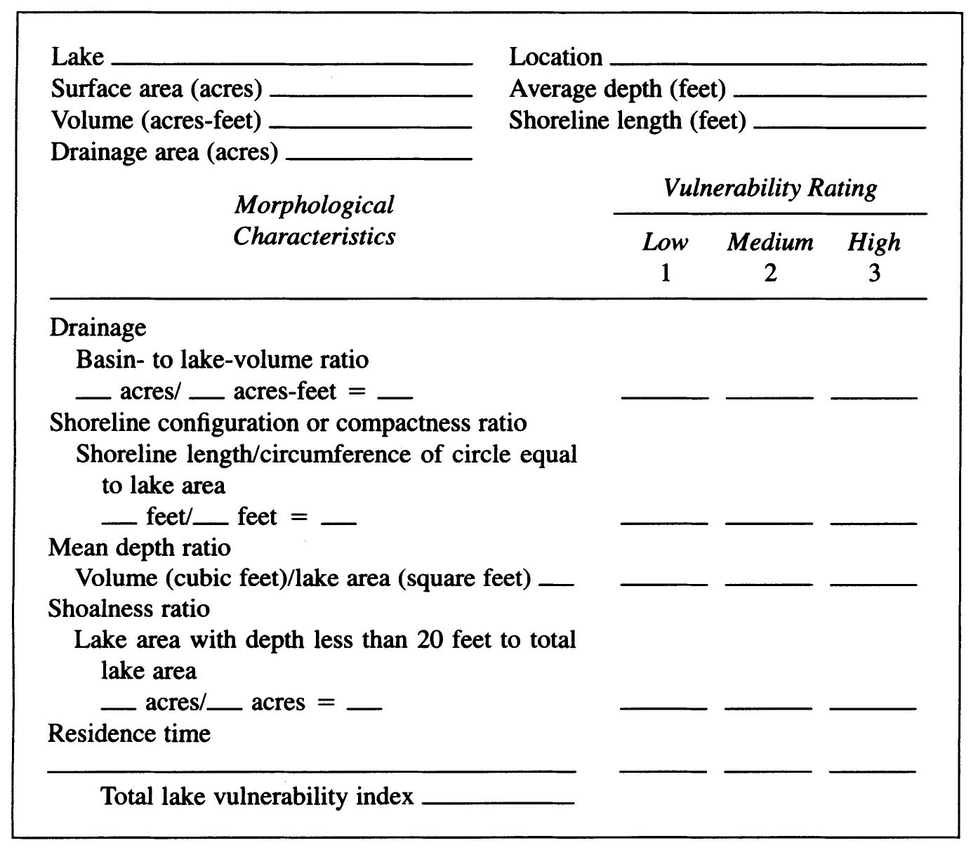
FIGURE 8.1. Index 1: Lake Vulnerability Compared to Other Lakes in Region Note: Indicators of lake vulnerability to accelerated aging are based on morphological characteristics.
Shoalness Ratio. The percentage of lake bottom areas that lies 20 feet or less below the water surface may be used as a vulnerability indicator. Light penetration to bottom sediment depends on various factors such as water color, turbidity, mineral content, and algal biomass. Twenty feet may be taken as the lower limit of the photic zone. Nutrients in sediments at this depth are readily available for the growth of water plants and algae under normal circumstances. This area of the lake is therefore most likely to exhibit the symptoms of excessive fertility, given the introduction of sufficient levels of nutrients. Thus, the greater the percentage of lake bottom that is less than 20 feet below the surface, the more vulnerable the lake is to accelerated eutrophication.
Mean Hydrologic Residence Time. The amount of time that inflowing water stays in a lake is called residence time. The shorter the residence time of a lake, the less high-nutrient inflows will affect it because they will be flushed through the basin more quickly (again, assuming all other factors to be invariable).
The above indicators of lake vulnerability were chosen for two reasons. First, although not exactly predictable, such relationships do exist and they are direct. Second, information pertaining to these indicators is readily available from state agencies or else can be collected inexpensively.
INTERPRETATION OF INDEX 1
Once the data are summarized, they can be taken to an expert in the water resources department or at the state university for interpretation. All five indicators are considered separately and then rated as follows: low (1), medium (2), or high (3) vulnerability. The three rating numbers are based on an approximate division into thirds of the values obtained for each factor in a survey of a number of lakes in the region. A comparative basis for evaluation is necessary, for there is no accepted criterion that pinpoints the value or range of values for low, medium, or high vulnerability.
In the absence of comparative data on other lakes, index 1B may be used (see fig. 8.2). This interpretation is based on an average of data from similar technical reports. It will give a preliminary indication of vulnerability for a single lake. This can also be interpreted by experts in the water resources department or at the state university.
INDEX 2: LAKESHORE LAND-USE INTENSITY3
The intensity of land use in the entire watershed is a measure of the lake’s vulnerability to pollution or eutrophication. It is also an indication of cultural, that is, manmade and therefore controllable, contributions to the aging process. The lakeshore land-use intensity index is based on a rating of the major types of human-influenced land uses that are recognized as having an effect on lake water quality. The intensity of each type of land use is rated on a scale from low to high, indicating its potential impact on the lake. The watershed assessment is then divided into two components: lakeshore land use within 1,000 feet of the shoreline, and watershed land use in the rest of the area that drains into the lake.
Index 2 (fig. 8.3) displays four factors to determine the impact on water quality of lakeshore land use. Each factor deals with shoreline use that di-rectly affects water quality: traditional on-site sewage-disposal systems, developed lot size, road proximity, and intensive public use areas.
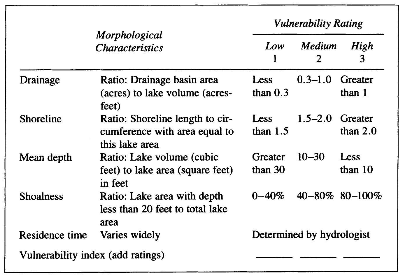
FIGURE 8.2. Index 1B: Lake Vulnerability for a Single Lake
On-Site Sewage Disposal Systems. Inadequately constructed or maintained on-site septic tank and drainfield sewage systems are potentially significant polluters. When septic systems are installed within 200 feet of a lakeshore, there is a risk that some of the nutrients, bacteria, and other pollutants can enter the lake. Traditional septic systems, however, are not inherently inappropriate. Adequately sized, properly maintained, and regularly inspected septic systems provide on-site wastewater treatment that is biologically equivalent to that provided by many centralized town or village sewage treatment plants. For such systems to function properly, though, they must be located a suitable distance from all water sources, and, most importantly, drainfields must be placed in living, loamy soil to allow aerobic bacteria to perform their biological and mechanical cleansing actions, which is equivalent to tertiary treatment at a centralized waste treatment plant.4
Developed Lot Size. Crowding structures along the lakeshore affects water quality directly because it increases the potential for pollutants from improperly designed or inadequately maintained septic systems or from boating and swimming. Crowding also means more runoff from near-shore areas. Development of houses, roads, and related support systems usually brings with it an increase in paved surfaces and a reduction of those plants and grasses that absorb rainfall. Lots averaging less than 100 feet in width may have inadequate surface area to absorb increased runoff or to mitigate the effect of contaminants.
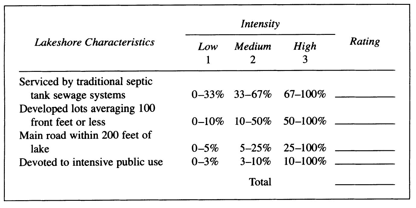
FIGURE 8.3. Index 2: Lakeshore Land-Use Intensity
Road Proximity. The proximity of a road to the lakeshore is important to water quality. Roads 200 feet or less from the shore often define the boundary lines of lakeshore property. This can limit the space available for well-designed septic systems. Also, roads mean less vegetative cover, which increases the amount and reduces the quality of runoff.
Intensive Public-Use Areas. These areas include marinas, boat-launching sites, public and private beaches, youth camps, picnic areas, campgrounds, and other intensively developed public and private lands. Land use contributes to lake water deterioration in several ways. Motorboats introduce oil and other chemicals into the water and cause shore erosion through wave action. Effects can be especially harmful when public areas concentrate several intensive water uses in relatively small areas.
INDEX 3: UPLAND WATERSHED LAND-USE INTENSITY
The remaining land-use categories that directly affect water quality are intensive development, agriculture and open space, and forest cover (see fig. 8.4). These relate to upland land use, that is, the rest of the watershed area.
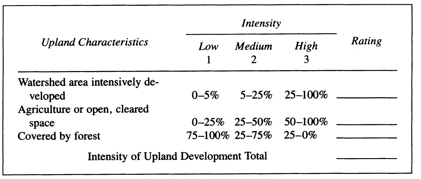
FIGURE 8.4. Index 3: Upland Watershed Land-Use Intensity
Intensive Upland Development. The higher the percentage of total watershed area covered by development, the greater the potential for accelerated eutrophication from sediments and nutrients. Intensive development in the upper areas of a watershed, like intensive development on a lakeshore, may have adverse effects on lake water quality as it implies a concentration of human-related activities which directly increase runoff flowing into the lake. Intensive development is defined here as any commercial or industrial development, any urbanized area (including villages and hamlets), and any cluster of five or more dwellings on five or less acres in the watershed.
Upland Agriculture and Open Space. Research demonstrates that runoff from cleared land (including both active and inactive farmland), some of which may be partially grown over, is a relatively heavy contributor of nutrients and pollutants to lakes and streams. Because cleared land is often used for human activity, it increases the probability of eutrophication.5
Upland Forest Cover. Forested land (except commercial tree farms or logging areas) is beneficial to the larger watershed area. Mature, established forests do not contribute to eutrophication because their sediments and nutrients are largely absorbed by the vegetative cover and soils of the forest floor. Note that the percentage of forest cover in table 4 is inversely proportionate to land-use intensity, that is, the more mature forest there is, the less the negative impact on a lake.
INTERPRETATION OF INDEX 3
As in the interpretation of the lakeshore area, here each development area is measured as a percentage of the total watershed area and then located in one of the percentage distributions. Rating values (1, 2, or 3) are then added to get a numerical total.
Seven ratings may now be generated from the examination of land use at the lakeshore and in the watershed. The first four ratings are added to arrive at an index number indicating the relative intensity of lakeshore development. The final three ratings are added to produce the lake basin land-use intensity index. Note that for the forest-cover component, the larger percentage of forest has a lower negative impact. Figure 8.6 gives an example of how an index is constructed from land-use ratings. The range of index numbers for upland land use is from 3, for a relatively undeveloped watershed, to 9, for a highly developed watershed.
INDEX 4: LAKE WATER QUALITY
Obtaining complete, objective, and scientific information on lake water quality can be time consuming and difficult. The best way for a rural planner or citizen to obtain this information is by interviewing experts in state agencies and at the state university. Experts include employees at the state department of water resources, health, and fish and game, and professors of limnology, aquatic biology, hydrology, geology, and planning. Interviews are easier when questions are organized in the form of a questionnaire (see fig. 8.5). On the basis of interviews, lake water quality can be given a rating of low (1), medium (2), or high (3) eutrophic level, and low (1), medium (2), or high (3) pollution level with reference to other lakes.
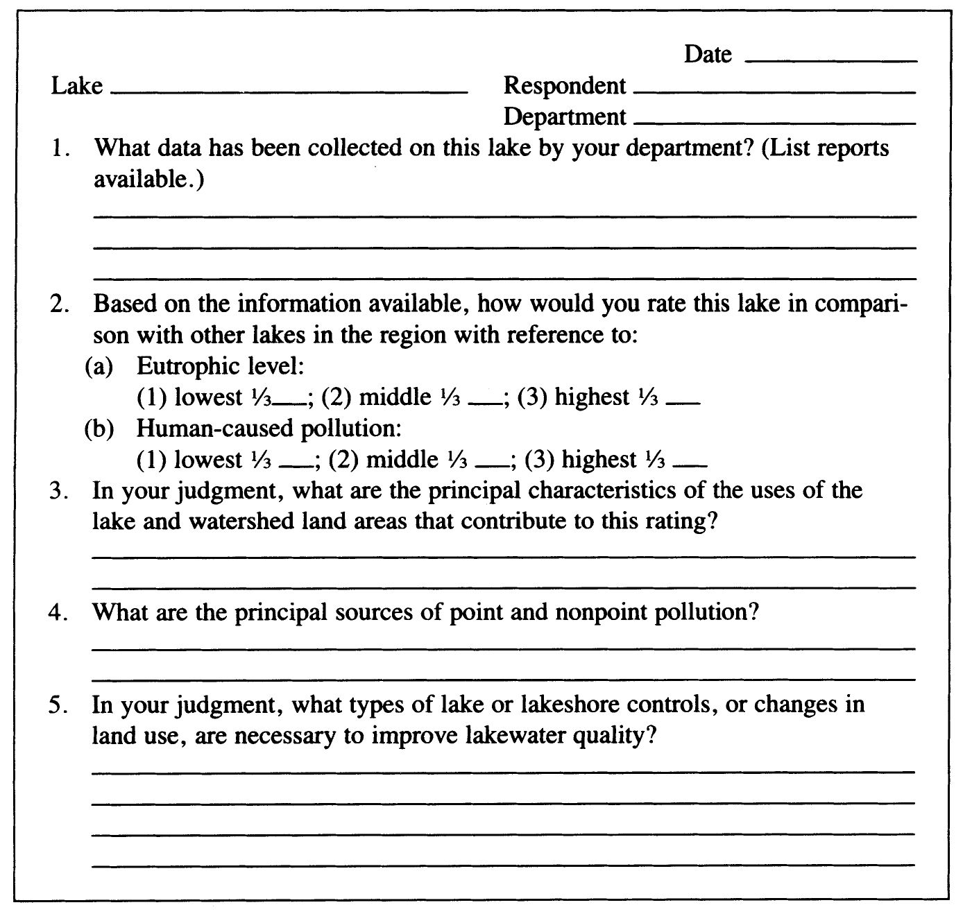
FIGURE 8.5. Index 4: Lake Water Quality Questionnaire
INDEX 5: COMBINED LAKE QUALITY INDICES
Now, combine all four indices to produce a four-digit number. The first digit indicates the level of lake vulnerability, the second and third digits indicate the intensity of lakeshore and upland land use, and the fourth digit indicates the level of water quality. The highest (negative) level in each category is 3, and the lowest (positive) level in each category is 1. A combined index may be constructed for each lake (see figure 8.6).
With the combined indexes, lakes may be classified to provide a basis for prescribing monitoring and management programs and for developing a comprehensive watershed plan. These indexes, which combine direct observation with the advice of state agency and university experts, permit local officials and local water committees to work with the environmental planner in forming a comprehensive plan for the lake basin as part of a rural environmental plan.
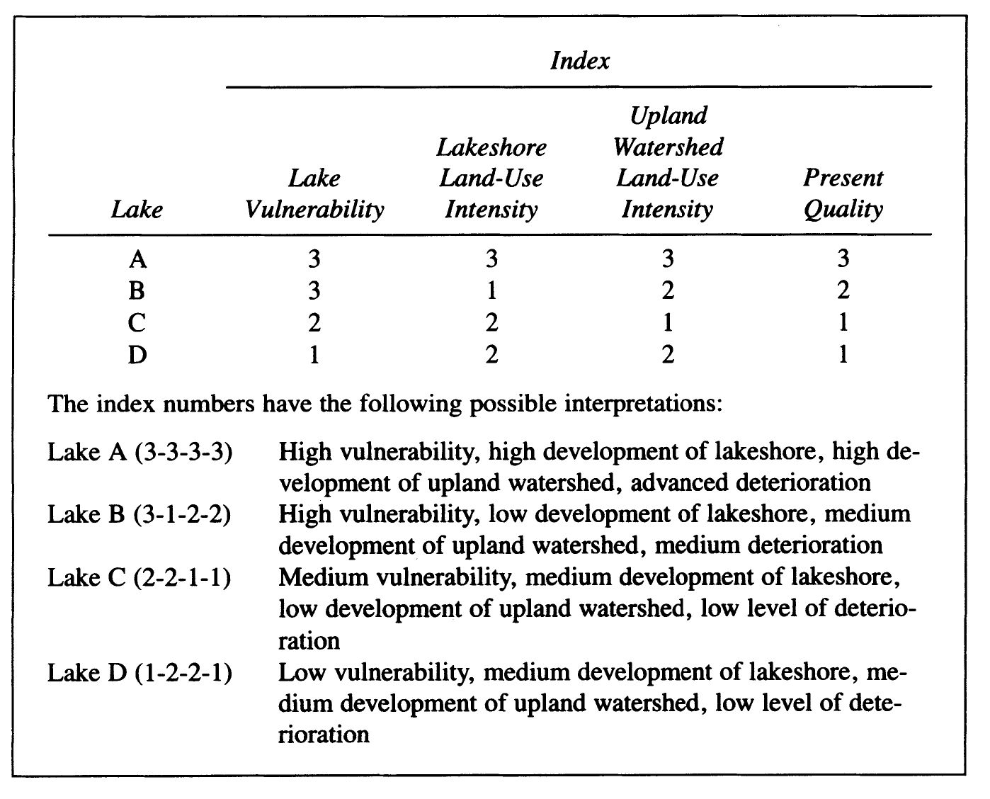
FIGURE 8.6. Index 5: Combined Lake Quality Indices
Examples of the practical application of this concept are the Granite Lake watershed in New Hampshire6 and the Seymour Lake watershed in Morgan, Vermont7. These two projects demonstrate the value of a special watershed plan to protect a community’s lake water. A lake basin plan includes land-use recommendations that have been agreed upon and that can be implemented by the local jurisdiction, the lakeshore owners’ association, and individual lot owners.
ALTERNATIVE WASTEWATER TREATMENT SYSTEMS
Because of their impact on water quality, the plan should give special attention to the location, number, and arrangement of building lots with access to a lakeshore. Strings of narrow lots with inadequately designed filter-field sewage disposals can lead to a polluted lake with low land values and reduced tax revenues. By requiring a 200-foot setback for buildings from the highwater mark and reserving a strip of public land along the shore, the local jurisdiction maximizes the number of people who use the lake and contribute to the local tax base. Minneapolis, Minnesota, has successfully planned some lakes in this way. Increased tax returns can be used for a sewer with watertight joints, cluster wastewater treatment, or other biologically sound systems. The costs and benefits should be studied carefully by a community planning a lakeshore.
Alternative on-site systems may be appropriate in low-density or cluster lakeshore developments where distances between lots, soil quality, or shallow bedrock conditions make traditional septic systems or sewer excavations inappropriate. For example, where space allows development but soils are inadequate, evapo-transpiration (ET) drainfield beds use replacement soil over contained, impermeable liners, which allow evaporation of drainage and biological processing of nutrients in the vegetated soilbed. A properly designed and constructed system can process 100 percent of the effluent with no discharge to surface or groundwater. Evapo-transpiration/absorption (ETA) beds are a variation that discharge to both the atmosphere and the groundwater when site size, configuration, and subsurface conditions are appropriate.
Other biologically sound on-site or cluster systems can be utilized in ecologically sensitive areas when environmental or economic conditions and community health requirements warrant. For small clusters, subdivisions with up to a few hundred units, aerobic, multichambered septic systems can produce effluent meeting federal standards for discharge to potable waters.8 For subdivision or large-scale developments, advanced centralized treatment systems such as enclosed solar aquaculture or constructed wetlands may be appropriate, particularly where water or discharge limitations make reuse and recycle options attractive.9
Where there are shallow soils, rock ledges, or severe limits on access to water, individual compost toilets are an option. A rural environmental plan for a town, lakeshore, or remote mountain area can specify performance requirements that allow individual waste-treatment choice and still reflect concern for public health and community utility and service costs. For example, in Sweden, which has extensive shallow soil and exposed bedrock, it is common to use in-house compost toilets in combination with water-conserving appliances. Small-scale, gray-water drainage systems are also extensively used. In Sweden and in other Scandinavian countries with long, subzero degree winters and shallow rocky soils, manufactured fiberglass interior toilets with a sloping composting chamber and a contributing chute from the kitchen for vegetable cuttings and other biodegradable wastes are fully sanctioned by environmental health agencies. These units have low-level air inlets and above-roof air outlets. They function as a low-temperature furnace volitolizing 90 percent of solids into harmless carbon dioxide gas and water vapor leaving a small, nearly odorless residue to be removed on an average of once every two to three years for a typical household of four persons.10
CASE: VERMONT ASSOCIATION OF CONSERVATION DISTRICTS
In Vermont, responsibility for management of on-site sewage disposal rests with local government. Although all towns have a health officer, many lack regulations governing on-site disposal. To induce them to adopt regulations and provide a service to homeowners, the Vermont Association of Conservation Districts (the coordinating organization for fourteen natural resource conservation districts) developed a multitown septic system design and inspection program in 1973. By 1988 the system had been adopted by over 107 towns.
To implement the inspection programs, a few changes were required in state health regulations and state law. One was to authorize on-site sanitary specialists and engineers, trained by the SCS, the Vermont Agency of Environmental Conservation, the extension service, and the state health department, to make inspections. Another measure was to replace percolation testing with soil analysis for determining a soil’s suitability for on-site disposal. SCS soil scientists assigned Vermont soils to ten categories according to their suitability for on-site disposal and established design standards for each soil type. The SCS provided maps and a classification and interpretation of soils for each of the ten classes.
Vermont’s Agency of Environmental Conservation and Department of Health also provide on-site sewage-system design criteria for each of the ten soil classes. Designs include recommended site modifications such as surface and subsurface drainage, benching, and filling to overcome site limitations.
The key to the program is the on-site sanitary specialist, employed by the natural resource conservation district, who performs an inspection at reasonable cost. The area covered by each specialist is determined by a workload of approximately two hundred sites per person per year. It amounts to five to fifteen towns per specialist. The specialists maintain an “open working schedule” and make many calls on weekends. Although sanitary specialists are assigned to specific towns, they may assist neighboring towns when the workload requires it.
The on-site sanitary specialist arranges for site inspection with the homeowner, installer, or contractor. The resulting report includes soil type, classification, and suitability for on-site disposal; recommendations for soil-related problems such as surface drainage, slope, and vegetative cover; basic criteria or a complete design for a disposal system; and provisions for compliance checks of the installation and an inspection report to the town board of health. The latter report is based on an inspection of the system before it is covered with earth. The SCS soil scientists and engineers assist when unusual site problems are encountered.
To participate in this program, a town first must adopt health regulations maintaining minimum standards for septic tank and leach-field installations. The town also must adopt a building-permit system and set a fee for inspection services. The on-site specialist assists the town in adopting these bylaws.
The Vermont program has grown at an encouraging rate. By 1988 all of the state’s fourteen natural resource conservation districts were sponsoring the on-site inspection program, employing a total of ten sanitary specialists. In 1987 specialists evaluated 1,120 sites alone. Since the program began in 1973 they have evaluated over 10,000 sites.
CONCLUSION
Goals for water resource planning are either obvious or relatively easy to determine. Goals in lake basin planning can be for agricultural and domestic use, for aesthetics or for recreation including boating, fishing, rafting, sailing, and swimming. Inventorying water conditions and their causes, however, is a complex procedure. Complexity and cost have been a major obstacle to locally initiated community planning for water resources. To resolve this problem the University of Vermont conducted a research program to develop a less expensive but scientifically acceptable means of obtaining such information. The program, which uses the indexing techniques presented in this chapter, is designed to be conducted by rural planners, students, or citizens with assistance from the state university and state agencies. The advantage of this program is the low cost of gathering data for the development of local plans for the management and protection of lake basins.