THE CRUST: EROSION AND DEPOSITION
The earth’s crust is influenced by three great processes which act together:
Gradation includes the various surface agencies (in contrast to the two internal processes below), which break down the crust (degradation) or build it up (aggradation). Gradation is brought about by running water, winds, ice and the oceans. Most sediments are finally deposited in the seas.
Diastrophism is the name given to all movements of the solid crust with respect to other parts (see here). Sometimes this involves the gentle uplift of the crust. Many rocks that were formed as marine sediments gradually rose until they now stand thousands of feet above sea level. Other diastrophic movements may involve intensive folding and fracture of rocks.
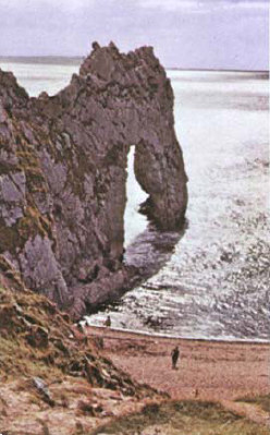
COASTLINES the world over provide evidence of changes in the earth’s unstable crust. The photograph shows cliffs made of rocks that were deposited under the seas that covered the area about 130 million years ago. These were uplifted and folded, so their original layers now stand almost vertical. At present they are undergoing erosion by the sea, typified by the form of the arch. Eroded material is being redeposited as a beach. The rocks of which coastlines are formed are themselves the result of earlier gradational events.
NATURAL ARCH reflects process of erosion, while deposition has produced the beach. Dorset, England.
Eruption of Kapoho, Hawaii, showing paths of molten lava
VULCANISM includes all the processes associated with the movement of molten rock material. This includes not only volcanic eruptions but also the deep-seated intrusion of granites and other rocks (see here).
These three processes act so that at any time the form and position of the crust is the result of a dynamic equilibrium between them, always reflecting the climate, season, altitude, and geologic environment of particular areas. As an end product of degradation, the continents would be reduced to flat plains, but the balance is restored and the processes of erosion counteracted by other forces that tend to elevate parts of the earth’s crust. These changes reflect changes in the earth’s interior (see here).
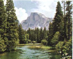
Yosemite valley is the result of interaction of various types of erosional processes.
EROSION involves the breaking down and removal of material by various processes or degradation.
YOSEMITE VALLEY in California is a good example of the complex interplay of gradational processes. A narrow canyon was first carved by the River Merced. This was later deepened and widened by glaciation. Running water is now modifying the resultant hanging and U-shaped valleys (see here), so characteristic of glacial topography. The level of the main valley floor lies 3,000 feet below the upland surface of the Sierras. Differences in topography are partly the result of differences in jointing and resistance of underlying granites. Half Dome and El Capitan are resistant granitic monoliths laid bare by this differential weathering. The region thus shows the effect of many degradational processes. But the 300-ft.-thick sediment on the valley floor reveals the continuing aggradational effects that are also at work.
WEATHERING
Weathering is the general name for all the ways in which a rock may be broken down. It takes place because minerals formed in a particular way (say at a high temperature in the case of an igneous rock) are often unstable when exposed to the various conditions affecting the crust of the earth. Because weathering involves interaction of the lithosphere with the atmosphere and hydrosphere, it varies with the climate. But all kinds of weathering ultimately produce broken mineral and rock fragments and other products of decomposition. Some of these remain in one place (clay or laterite, for example) while others are dissolved and removed by running water.
The earth’s surface, above the level of the water table (see here), is everywhere subject to weathering. The weathered cover of loose rock debris (as opposed to solid bedrock) is known as the regolith. The thickness and distribution of the regolith depend upon both the rate of weathering and the rate of removal and transportation of weathered material.

THE EFFECTS of weathering are most strikingly seen in arid and semiarid environments, where bare rocks are exposed without a cover of vegetation. Bryce Canyon, Utah, shows the effects of the bedding and differing resistance of rocks in producing distinctive erosional landforms. Weathering is of great importance to humankind. Soils are the result of weathering processes, and are enriched by the activities of animals and plants. Some important economic resources, such as our ores of iron and aluminum, are the result of residual weathering processes.

FROST SHATTERING is often produced by alternate freezing and thawing of water in rock pores and fissures. Expansion of water during freezing causes the rock to fracture.

SPHEROIDAL WEATHERING occurs in well-jointed rocks, because weathering takes place more rapidly at corners and edges (3 and 2 sides) than on single faces.
MECHANICAL WEATHERING involves the disintegration of a rock by mechanical processes. These include freezing and thawing of water in rock crevices, disruption by plant roots or burrowing animals, and the changes in volume that result from chemical weathering within the rock. This weathering is especially common in high latitudes and altitudes, which have daily freezing and thawing, and in deserts, where there is little water or vegetation. Rather angular rock forms are produced, and little chemical change in the rock is involved. It was once thought that extreme daily temperature changes caused mechanical weathering, but this now seems uncertain.
CHEMICAL WEATHERING involves the decomposition of rock by chemical changes or solution. The chief processes are oxidation, carbonation and hydration, and solution in water above and below the surface. Many iron minerals, for example, are rapidly oxidized (“rusted”) and limestone is dissolved by water containing carbon dioxide. Such decomposition is encouraged by warm, wet climatic conditions and is most active in tropical and temperate climates. Blankets of soil or other material are produced which are so thick and extensive that solid rock is rarely seen in the tropics. Chemical weathering is more widespread and common than mechanical weathering, although usually both act together.
SOIL is the most obvious result of weathering. It is the weathered part of the crust capable of supporting plant life. The thickness and character of soil depend upon rock type, relief, climate, and the “age” of a soil, as well as the effect of living organisms.
Immature soils are little more than broken rock fragments, grading down into solid rock. Mature soils include quantities of humus, formed from decayed plants, so that the upper surface (topsoil) becomes dark. Organic acids and carbon dioxide released during vegetative decay dissolve lime, iron, and other compounds and carry them down into the lighter subsoil.
Residual soils, formed in place from the weathering of underlying rock, include laterites, produced by tropical leaching and oxidizing conditions which consist of iron and aluminum oxides with almost no humus. Transported soils have been carried from the parent rocks from which they formed and deposited elsewhere. Wind-blown loess (see here), alluvial deposits (see here), and glacial till (see here) are common examples of transported soils.
LATERITIC SOIL PROFILE
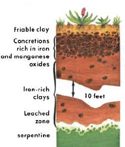
MATURE SOIL PROFILE

ROCK FALLS forming talus slopes are an example of mass wasting. The finer material tends to be concentrated near the base of the slope. Such falls may be either small and irregular or massive and sudden, causing a rock avalanche.
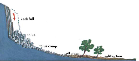
MASS WASTING is the name given to all downslope movements of regolith under the predominant influence of gravity. Weathered material is transported from its place of origin by gravity, streams, winds, glaciers, and ocean currents. Each of these agencies is a depositing, as well as a transporting agent and, though they rarely act independently, each produces rather different results.
The prevention of mass wasting of soil is of great importance in all parts of the world. Engineering and mining activities usually require geological advice on slide and subsidence dangers. Several tragic dam failures have resulted from slides. The Vaiont reservoir slide in Italy in 1963 claimed 2,600 lives. Careful geological site surveys can prevent such disasters.
EARTH FLOWS may be slow or very rapid. Slow movement (solifluction) takes place in areas where part of the ground is permanently frozen. These areas cover about 20 percent of the earth. On slopes, the thawed upper layer slides on the frozen ground below it. On flat ground, lateral movement gives stone polygons. Sudden flows may follow heavy rains.
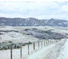
SOIL CREEP is the gentle, downhill movement of the regolith that occurs even on rather moderate, grass-covered slopes. It can often be seen in road cuts.

Hill creep affects fences and trees, as well as bending of vertical strata.
SLUMPS are slides in soft, unconsolidated sediment. Some are submarine in origin. Fossil slumps are recognizable in some strata. Usually, slumps are on a rather small scale, as when sod breaks off a stream bank.
SUBSIDENCE is downward movement of the earth’s surface caused by natural means (chemical weathering in limestone areas) or artificial methods (excessive mining or brine pumping). Heavy loading by buildings or engineering structures may also cause subsidence.
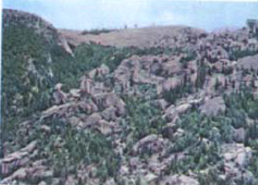
Typical landslide topography in Wyoming shows debris of huge boulders.
LANDSLIDES are mass movements of earth or rock along a definite plane. They occur in areas of high relief where weak planes—bedding, joints, or faults (see here)—are steeply inclined; where weak rocks underlie massive ones; where large rocks are undercut; and where water has lubricated slide planes.

Rock glaciers involve slow downslope movement of “river” of rock.
RUNNING WATER
Running water is the most powerful agent of erosion. Wind, glaciers, and ocean waves are all confined to relatively limited land areas, but running water acts almost everywhere, even in deserts. One fourth of the 35,000 cubic miles of water falling on the continents each year runs off into rivers, carrying away rock fragments with it. In the United States, this erosion of the land surface takes place at an average rate of about one inch in 750 years. Running water breaks down the crust by the impact of rock debris it carries.
THE HYDROLOGIC CYCLE is a continuous change in the state of water as it passes through a cycle of evaporation, condensation, and precipitation. Of the water that falls on the land, up to 90 percent is evaporated. Some is absorbed by plants and subsequently transpired to the atmosphere, some runs off in streams and rivers, and some soaks into the ground. The relative amounts of water following these paths vary considerably and depend upon the slope of the ground; the character of the soil and rocks; the amount, rate, and distribution of rainfall; the amount and type of plant cover; and the temperature. The hydrosphere is estimated to include over 300 million cubic miles of water, about 97 percent of which is in the oceans.

A single shower may involve the downpour of more than a billion tons of water. Each raindrop in the shower becomes important in erosion, especially in areas with sparse vegetation and unconsolidated sediments. Runoff water rarely travels far as a continuous sheet, for it is broken up into rivulets and streams by surface irregularities in rock type and relief.
Running water carries its load of rock debris partly in suspension, partly by rolling and bouncing it along the bottom, and partly in solution. The carrying power of a stream is proportional to the square of its velocity, and so is enormously increased in time of flood.
THE FORM OF RIVERS depends upon many factors. Water runs downhill under the influence of gravity, the flow of the water being characteristically turbulent, with swirls and eddies. The overall long profile of a river valley is concave upwards, however much its gradient (its slope or fall in a given distance) may vary. The velocity of the stream increases with the gradient, but also depends on other factors, including the position within the river channel, the degree of turbulence, the shape and course of the channel, and the stream load (transported materials).

Diagrammatic model of a river system, showing cross sections of channel at three points
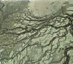
DENDRITIC DRAINAGE PATTERN of Diamantina River, Queensland, Australia, is typical of river development in areas where the underlying rocks are relatively uniform in their resistance to erosion. This pattern may be modified by continued downcutting of the river.
RIVER PROFILES reflect the varying development of drainage systems. During early development, changes are reflected by direction and shape of stream courses. Ultimately, erosion produces an equilibrium between the slope and volume of the river and its erosional and depositional power. This results in a graded profile, or profile of equilibrium. Final equilibrium is never reached because of seasonal and geologic changes. The downward limit of erosion by a river is the base level, below which the river cannot downcut appreciably because it has reached the level of the body of water into which it flows. Sea level is the ultimate base level for all rivers. Larger rivers and lakes into which rivers flow constitute local base levels.
Stages in the cycle of river erosion were once labeled as “youth,” “maturity,” and “old age.” Although these stages describe certain characteristics, they imply no particular age in years, only changing phases in development. Rivers often show a condition of old age near their mouths, but are mature or youthful in their higher reaches. For that reason, the terms are rather misleading, and are now rarely used.
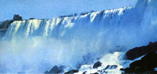
Niagara Falls are formed by resistant bed of dolomite.
RIVER PROFILES are influenced by geology and structure of their drainage area and tend to assume a graded, concave profile as they approach equilibrium.

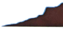
Longitudinal profile
IRREGULAR PROFILE—common in upstream portions of rivers—shows high gradients, waterfalls, rapids, steep-sided valleys, irregular courses, few tributaries, and erosion. The Gunnison River in Colorado is an example.
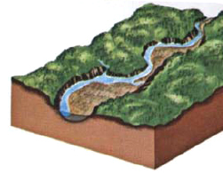

Longitudinal profile
SMOOTHER STEEP PROFILE is steep, with high relief, but fewer irregularities. Erosion and transportation of underlying rocks gives wider valleys and smoother topography. Tributaries are well-established. The White River of south western Missouri shows these features.
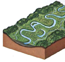

Longitudinal profile
GRADED PROFILE reflects deposition of transported load. The river flows sluggishly over a wide, flat flood plain, with meandering pattern, ox-bow lakes, and sand bars. This represents a baseline equilibrium between erosion by the river and deposition in the sea or lake into which it flows. The lower Mississippi and Amazon are examples.
REJUVENATION or uplift may interrupt the cycle of erosion at any stage to provide new energy for downcutting. The character of the stream is then often a combination of recently cut, steep gorges in an older meander course. Ancient flood-plains are often left “stranded” as terraces. Uplift and warping may be relatively sudden or slow, frequent or rare, local or regional in extent.

Terraces are cut as river swings from one side of valley to other.

WATERFALLS AND RAPIDS are local increases in gradient in the long profile of a river. Most are due to unequal erosion of the stream bed.
THE FALLS of the Yellowstone River (the lower of which is twice as high as Niagara Falls) result from resistant lava flows. Niagara Falls is held up by an 80-foot-thick bed of dolomite, which is more resistant to erosion than the underlying shales and thin limestones.
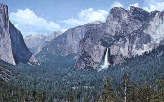
Other falls result from over-deepening of a main valley, often by ice, as in the Bridal Veil Falls in Yosemite, so that the tributaries are left “hanging” (see here). Continued erosion by a stream leads to upstream migration and ultimate smoothing out of waterfalls.

UNEQUAL EROSION has already cut Niagara Falls back about 7 miles from the Niagara escarpment, since it began cutting about 9,000 years ago. The weaker shales below the Lockport Dolomite are undercut by the turbulent water in the plunge pool, so that the overlapping dolomite is undermined, and eventually collapses. The Niagara River flows into Lake Ontario from Lake Erie, which will ultimately be drained by upstream migration of the falls.

STREAM PIRACY takes place when the tributaries of one stream (A) erode faster than those of another (B) in the same area. The headwaters of the less active stream are ultimately diverted or cut off. When such “beheaded” streams abandon their path through a ridge, a wind gap results.

DELTAS are masses of sediment deposited where rivers lose their velocity as they enter lakes or seas. Thick, relatively uniform layers of sediment accumulate on the steep outward slope. Deltas of the Mississippi, Ganges, and Po are thousands of square miles in area. Deltas have a characteristic stratification in their deposits.

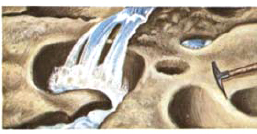
POTHOLES are circular hollows in a stream bed, drilled out by swirling currents of water carrying gravel and pebbles. This “hydraulic drilling” is an important method of down-cutting, even in hard rock.
DRAINAGE
CONSEQUENT STREAMS flow in directions determined largely by the original slope and shape of the ground. When their courses are modified by features of the geology, such as valley cutting in soft strata, the adjusted tributaries are known as subsequent streams.

DENDRITIC drainage patterns are those that show treelike branching because the bedrock has a uniform resistance to erosion and does not influence the direction of stream flow.

TRELLIS patterns are characteristic of uniformly dipping or strongly folded rocks. In this rectangular pattern, the tributaries are nearly perpendicular to the main stream.

SUPERIMPOSED drainage generally has stream courses that are independent of rock structure. A stream’s erosional power may have been strong enough to maintain its antecedent course during uplift and development of a new geological structure. Or it may keep its same course after it cuts through younger, overlying, flat, sedimentary rock to an older, irregular rock mass.

PATTERNS
RADIAL patterns develop on young mountains, such as volcanoes where streams radiate from the high central area.

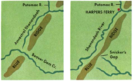
Piracy may cause river diversion. Ancestral Shenandoah River captured headwaters of Beaver Dam, leaving an abandoned water gap.
MODIFIED DRAINAGE may be caused by piracy (see here) as well as by glacial or volcanic blocking of stream courses. Glacial diversion results from overdeepening of basins and river valleys by ice, blocking of drainage by ice, morainic deposits, and meltwater, which may produce glacial lakes and new outlets. Changes in sea level may also modify drainage.

Great Lakes basins were carved by ice from soft strata. Original drainage was blocked by ice, producing local crustal depressions.
EROSIONAL LANDFORMS are produced by running water and other erosional agents. Mesas are flat-topped rock mountains, which stand as remnants of a once continuous plateau. Buttes are smaller examples of the same thing. Monuments describe any isolated rock pinnacle.
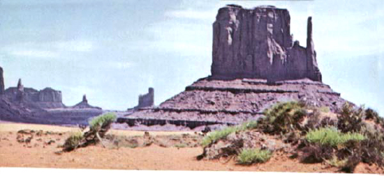
HOGBACKS are long ridges formed by steeply dipping resistant strata; cuestas are gently sloping ridges formed in gently dipping strata.

NATURAL BRIDGES are formed of resistant strata, usually sandstone or limestone. Underground erosion has taken place below the original stream bed.
PINNACLES at Bryce Canyon, Utah, show differential weathering. Erosion has removed the softer, more soluble rocks. Rocks here are of Tertiary (Eocene) age.

GROUNDWATER is found almost everywhere below the earth’s surface. Most originates from rain and snow, but small quantities come from water trapped in sediments during their deposition (connate water) or from igneous magmas (juvenile water).
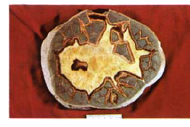
SEPTARIAN NODULE is formed from minerals deposited by groundwater in claylike rocks. Groundwater is an important agent in both deposition and erosion of surface rocks. It can dissolve original cementing materials and deposit new ones. For example, it produces caves and caverns by solution in carbonate rocks.
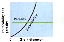
POROSITY, the percentage of pore space to total volume of a rock, depends upon the grain size, shape, packing, and cement of rock particles. The permeability of a rock, or its capacity to transmit or yield water, depends upon the size of pores, rather than their total volume. Pores smaller than 1/20 of a millimeter will not allow water to flow through them.
WELL-SORTED SAND (enlarged view) with high porosity due to sorting, which has removed fine-grained particles

POORLY SORTED SAND has lower porosity than well-sorted sand, because the pore spaces are filled by fine particles.

LIMESTONES generally hold water in enlarged joints formed by solution; they lack the “pore space” of sandstones.

THE WATER TABLE depends on the distribution of groundwater. The open spaces in the rocks of the upper part of the crust are filled mainly with air. This is the zone of aeration. Water moves downward through this zone into the zone of saturation, where openings are filled with water. The upper surface of this saturated zone is the water table. In most areas, the water table is only a few tens of feet below the surface, but in arid regions, it is much deeper. Water-bearing rocks are rarely found below 2,000 feet. Rock pores are closed by pressure at depth, and this determines the lower limit for groundwater. Most rocks will give off water whenever they intersect the water table. But the level of the water table falls after a dry season, so rock formations must be deep enough to penetrate the water table all year round. Sometimes a perched water table results when a pocket of water is held above the normal water table by a saucer of impervious rock. Any water-producing rock formation is called an aquifer.

ARTESIAN WELLS are those where water is confined to a permeable aquifer by impervious beds, and where the catchment or intake area (and thus the water level in the aquifer) is higher than the well head. This allows the water to flow toward the surface under its own internal pressure.

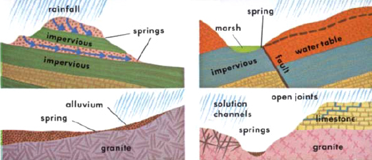
SPRINGS are sources of running water produced by the water table intersecting the ground surface. A few of the many ways they can be formed are shown in the diagrams below. Some springs are dry at seasons when the water table is depressed; others flow without interruption.
HOT SPRINGS are generally confined to areas of recent vulcanism where groundwater is heated at depth by contact with igneous magmas. Such springs are well developed in Yellowstone National Park and North Island, New Zealand. Terrace deposits may be produced when hot spring water deposits dissolve mineral matter. Mammoth Springs of Yellowstone National Park are formed of calcium carbonate (travertine). Geysers, intermittent fountainlike hot springs, often build cones of siliceous geyserite.
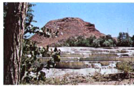
Hot Springs, Thermopolis, Wyoming
FUMAROLES are gentle geysers located in volcanic regions that emit fumes, usually in the form of steam.
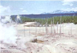
Norris Geyser Basin, Wyoming
GEYSERS are thermal springs that periodically discharge their water with explosive violence. All geysers have a long narrow pipe extending down from their vents into their reservoirs. A build-up and sudden release of steam bubbles probably relieves the pressure on the heated water below ground so that it boils and surges upward. The period between eruptions varies from minutes to months in different geysers, depending upon the structure of the geyser, its water supply, and its heat source.
OLD FAITHFUL in Yellowstone National Park discharges a column of water and steam up to 170 feet high approximately every 65 minutes.

Typical geyser structure shows complex system of fissures extending down to regions where ground water becomes superheated and finally erupts.

Geyserite (Sinter)

Pudding Basin Geyser, New Zealand shows typical eruption.
CAVES reflect the work of groundwater. Limestone is dissolved by circulating water in subsurface joints and fissures. The enlargement gradually produces a cave. Inside a cave, dripping water, rich in calcium bicarbonate and CO2, often produces precipitates that form stalagmites and stalactites.

GEOLOGICAL WORK OF GROUNDWATER is important in solution and deposition in the rocks through which it passes. It dissolves limestone and other carbonate rocks to form caves and sink holes. Limestone areas are often marked by a karst topography of sinks, few surface streams (they flow underground), and large springs. In caves, the deposition of calcite dissolved in dripping groundwater produces stalactites, icicle-shaped formations hanging from the cave ceilings, and stalagmites, formations that build up from the cave floor. The carrying away of minerals in solution usually occurs above the water table. Below that level, deposition, replacement, and cementation are important. Ball-like masses (concretions), hollow, globular bodies (geodes), and the cement in many sedimentary rocks are the result of the action of groundwater at depth.

KARST TOPOGRAPHY
THE EARTH’S WATER SUPPLY is one of its most precious natural resources. Although nearly three quarters of the globe is covered by water, over 97 percent of the 326 million cubic miles of earth’s water is locked up in the oceans, too salty for drinking water or for agriculture. Another 2 percent is frozen in glaciers and ice sheets. The tiny fraction that is available for water supply is very unevenly distributed. One third of the earth’s land surface is desert or semiarid. Even in humid areas, water supply and conservation present major problems. The location and development of new industries depend upon adequate water supplies. World demand for water is expected to double in the next twenty years. It requires 600,000 gallons of water to produce one ton of synthetic rubber. The daily consumption of the average household in the United States is 400 gallons.

Cotter Dam supplies water for Australian capital city of Canberra.
About three quarters of the water used in most humid industrial areas comes from surface waters (rivers, lakes, artificial reservoirs, etc.). The rest comes from groundwater. Pollution and waste still prevent maximum use of surface waters, on which we depend.
Over one fourth of the earth’s land surface is desert, and dam construction can be vital in these areas. The Aswan Dam in Egypt brought almost 2.5 million acres of new land into cultivation and generates 10 billion kilowatt-hours of electricity each year. Desalinization of sea water, although used in some arid areas, is still too expensive for general use.
Water conservation is a pressing world need since supplies, although they are never exhausted but are replenished in the water cycle, can never be increased. They can, however, be more efficiently used and distributed. Pollution of water supplies by domestic and industrial wastes can upset the delicate ecological balance, and has very serious biologic, economic, and recreational effects.

Arid and semiarid regions cover about 1/3 of the earth’s surface. This water hole in Pakistan is typical of local water supplies.
GLACIERS AND GLACIATION
We live today in the twilight of a great episode of refrigeration, when much of the Northern Hemisphere was covered by continental ice sheets, like those that still cover Antarctica and Greenland. Although the ice itself has now retreated from most of Europe, Asia, and North America, it has left traces of its influence across the whole face of the landscape in jagged mountain peaks, gouged-out upland valleys, swamps, changed river courses, and boulder-strewn, table-flat prairies in the lowlands.
Glaciers are thick masses of slow-moving ice. In the higher lands and polar regions, the annual winter snowfall usually exceeds the summer loss by melting. Permanent snow fields build up, and their lowest boundary is the snow line, the actual height of which varies with latitude and climate. Buried snow recrystallizes to form ice, which moves slowly under its own weight. It moves most rapidly in the middle of the glacier.

Lake Solitude, Wyoming, a typical area of recent glaciation
GLACIAL EROSION has a powerful effect upon land that has been buried by ice and has done much to shape the mountain ranges of our present world. Both valley and continental glaciers acquire many thousands of boulders and rock fragments, which, frozen into the sole of the glacier, gouge and rasp the rocks over which the glaciers pass. The rocks are slowly abraded down to a smooth, fluted, grooved surface. Glacial meltwater, from periods of daylight or summer thaw, seeps into rock fissures and joints. When it freezes again, it helps to shatter the rocks, some of which may become frozen into the body of the glacier and be carried away as the glacier moves downslope. Avalanches and undercutting of valley sides add to the rock debris.
ROCK SURFACES display fluting, striation, and polishing effects of glacial erosion. The form and direction of these grooves can be used to show the direction in which the ice moved.

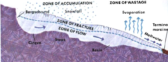
TYPICAL LONGITUDINAL SECTION of a valley glacier shows its structure and its profile of bedrock. Surface ice is brittle, but underlying ice crystals bend, shear, and glide, causing ice to flow by deformation.


During
After
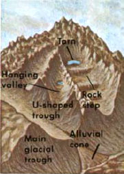
THREE STAGES OF GLACIAL EROSION are illustrated above, showing mountain country before, during, and after glaciation. Glaciers cut U-shaped valleys, modifying and deepening the interlocking pattern of earlier meandering river erosion. The valleys are straightened and truncated by ice flow. Tributary hanging valleys develop where the rate of erosion by tributary glaciers is lower than that of the glacier in the main valley. As the ice retreats, waterfalls flow out of them into the main valley.

U-shaped glaciated valley, Clinton Canyon, New Zealand
HORNS, ARETES, AND CIRQUES are all products of glacial erosion. Horns are sharp, pyramidal mountain peaks formed when headward erosion of several glaciers intersect. Aretes are sharp ridges formed by headward glacial erosion. Continental glaciers tend to produce a smoothed-out effect on the landscape, such as that of the Laurentian Shield in Canada. Cirques are bowl-shaped valleys formed at heads of glaciers and below aretes and horned mountains; often contain a small lake, called a tarn.
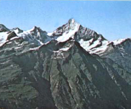
Horns and aretes in glaciated area, Switzerland

IDEALIZED GLACIAL LANDSCAPES show typical depositional features. They are collectively called till deposits. Glacial deposits of rock fragments are carried by the glacier on its surface within the ice and at its base. This material is deposited either beneath or at the foot of the ice field, forming unsorted and unbedded “till.” Meltwater streams flowing from the glacier form sorted, stratified glaciofluvial or outwash deposits. These and other glacial deposits are often described as “drift.” Deposits also occur during retreat of ice.
MORAINES are deposits of glacial till formed either as arcuate mounds at the snout of the glacier (terminal moraines) or as sheets of till over considerable areas (boulder clay). Successive terminal moraines often mark retreat stages of glaciers (recessional moraines). Moraines are made up of a variety of unsorted rock fragments in unbedded clay matrix.
ERRATICS are boulders of “foreign” rock carried by glaciers. Some are up to 100 feet across, and most are found many miles from their points of origin. They often have blunted edges and rather smooth faces, but most lack glacial striations.
DRUMLINS are low, rounded hills, sometimes reaching a mile in length, found in glaciated areas. Aligned in the direction of ice flow, their steeper, blunter ends point toward the direction from which the ice came. They are formed by plastering of till around some resistant rock mass. They produce a characteristic “basket-of-eggs” topography.

KAMES are isolated hills of stratified material formed from debris that fell into openings in retreating or stagnant ice. Kame terraces are benches of stratified material deposited between the edge of a valley glacier and the wall of the valley.
GLACIOFLUVIAL DEPOSITS are all sorted and bedded stream deposits. Outwash deposits, formed by meltwater streams, are flat, interlocking alluvial fans.
ESKERS are long, narrow, and often branching sinuous ridges of poorly sorted gravel and sand formed by deposition from former glacial streams.
KETTLE HOLES are depressions (sometimes filled by lakes) due to melting of large blocks of stagnant ice, found in any typical glacial deposit.
GLACIAL LAKE DEPOSITS are formed either by meltwater or the blocking of river courses. Deltas and beaches mark the levels of many such lakes.
VARVE CLAYS are lake deposits of fine-grained silt, showing regular seasonal alternations of light-colored, thicker bands deposited during wet, summer months and thinner, dark bands representing the finer, often organic, material of winter deposits that settle below the frozen lake surface.

ANCIENT PERIODS OF GLACIATION produced land features still in evidence today. The features already described can be seen in connection with existing glaciers, but older glacial deposits and erosional features prove the occurrence of earlier glacial episodes. The most recent of these is the Pleistocene glaciation which began about two million years ago. It involved four major episodes of glaciation, when continental ice sheets covered about one quarter of the earth’s surface, including parts of North America, northern Europe, and northern Asia. Glacial advances were separated by warmer, interglacial periods. In the areas outside those covered by glaciers, especially in the Southern Hemisphere, corresponding pluvial periods of abnormally heavy rainfall marked Pleistocene times, probably caused by changes in the general pattern of wind circulation produced by continental glaciers.
Pleistocene glaciation molded such familiar features of our present landscapes as the jagged peaks of the Rockies and the Alps, the rich farm soils of the northern midwestern states, and the Great Lakes.

Maximum extent of Pleistocene ice sheets and glaciers
GLACIATION is important because it has molded the topography of much of the Northern Hemisphere. It also poses a number of basic geologic problems.
CHANGES IN SEA LEVEL of up to 300 feet occurred when much of the ocean’s water was locked in continental glaciers. Even today, if present glaciers and ice sheets that cover 10 percent of the earth’s surface were to melt, sea level would rise by some 300 feet. The continental margins would be flooded, and many of the world’s major ports would be submerged. This may happen again. If it does not, and we are instead living in an interglacial rather than postglacial episode, then continental glaciers may again spread across much of the earth.
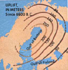
LOADING THE CRUST by ice caused sags to develop which reached about 1,500 ft. under the thickest ice. With the melting of the glaciers, the crust began to rise again, and the history of this rise can be traced in Scandinavia, North America, and Europe. The crust rises about 9 inches per century.
CAUSES OF ICE AGES are still unknown. Possible causes may be changes in the broad pattern of the circulation of the oceans, changes in the relative position of the earth and sun, changes in solar radiation, and the presence of some blanket such as volcanic dust to reduce solar radiation reaching the earth. It has also been suggested that the Pleistocene glaciation of the Northern Hemisphere could have been the result of surges in the Antarctic ice sheet producing wide ice shelves around the Southern Ocean, which cooled the Northern Hemisphere.
PRE-PLEISTOCENE GLACIATIONS are much less easy to detect than the very recent Pleistocene. One major episode of glaciation took place in the Southern Hemisphere in Permo-Carboniferous times, about 230 million years ago. Tillites (indurated glacial tills) and striated rock pavements show large areas of Australia, South America, India, and South Africa to have been glaciated. The character of these glacial deposits suggests that these areas, now remote, formed a single massive continent (Gondwanaland) at that time.
There is also evidence of an Ordovician (about 450 million years ago) and a late Pre-Cambrian glaciation (about 600 million years ago).
THE OCEANS
Oceans play a major role in the earth’s natural processes because of their production and control of climate, supplying moisture to the atmosphere and providing a vast climatic regulator. They form the ultimate site of deposition of almost all sediment and are the home of many living species of animals and plants. The oceans cover over 70 percent of the earth’s surface. The continents are surrounded by shallow, gently sloping continental shelves. The average ocean depth is almost three miles, but trenches, up to 36,000 feet deep, are found in places. Although much of the deep ocean floor is a flat plain, some parts are more mountainous than the mountain regions of dry land. A worldwide system of midoceanic ridges includes submarine mountain chains, marked by intense vulcanism and earthquake activity, and offset by transform faults. They are the sites of the formation of new crustal rocks (see see). There are also many volcanic islands, including many submerged below sea level.

California Coast shows force of breaking waves eroding shoreline.
1. N. Equatorial
2. S. Equatorial
3. Eq. countercurrent
4. N. Atlantic drift
5. N. Pacific
6. Humboldt
7. Kuroshia
8. Alaska
9. Labrador
10. Canaries
11. Falkland
12. Benguela
13. West Wind Drift
14. Florida
15. California

CURRENTS have a major influence on world weather patterns. Differences in the density of sea water of varying salinity and differences in temperature produce water circulation in the oceans. The colder, more saline, denser water sinks downward to produce deep ocean currents. Nearer the surface of the sea, the combined influence of winds and the rotation of the earth produce the more familiar surface currents, including the Gulf Stream. These surface currents follow great, swirling routes around the ocean basins and the equator. Some currents move at speeds of over 100 miles a day.
SEA WATER includes about 3.5 percent of dissolved chemicals by weight. Salt (NaCl) is the most common solute, with smaller quantities of magnesium chloride, magnesium and calcium sulfates, and traces of about 40 other elements. Salinity is the number of grams of these dissolved salts in 1,000 grams of sea water. Although the proportions of these salts to one another are very similar throughout the oceans of the world, the total salinity of the oceans varies from place to place and with depth. It is low near river mouths, for example, and high in areas of high evaporation.
TIDES are twice-daily movements of billions of tons of ocean water influenced by many factors on the surface of the earth as well as from space. Mainly, the gravitational pull of the moon upon the earth causes the waters to bulge toward it twice a day, creating what we call high tides. The corresponding bulge or high tide on the distant side of the earth from the moon is caused by the corresponding lower attraction of the moon at this greater distance, allowing the oceans to “swing” outward. Tides rise only two or three feet on open coastlines, but in restricted channels can reach fifty feet.

WAVES are produced chiefly by the drag of winds on the surface of water. The water is driven into a circular motion, but only the wave form, not the water itself, moves across the ocean surface. Waves generally affect only the uppermost part of the oceans. Wave base is half the wave length of any particular wave system. When they run into shallow water, waves drag bottom, and the topmost water particles break against the shore. Waves play an important part in the shaping of coastlines, both in sediment transport and in erosion. Some large waves (tsunami) are caused by earthquakes.


THE EDGES OF THE CONTINENTS are commonly marked by margins of broad, flat shelves which slope gently (at about 1:1000) to a depth of about 450 feet. At this depth, they merge into the steeper continental slope. The width of shelves varies from a few miles to 200 or more miles. Commonly, shelves are about 30 miles wide. The shelves seem to be formed by the deposition and erosion of fairly young sediments, many of them of Pleistocene age. Changes in sea level of some 500 feet have been involved during this period.
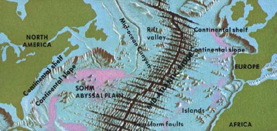
THE CONTINENTAL SHELF AND SLOPE rim the continents, the wide shelf dropping off steeply at the slope to the depths of the seafloor. At the base of the continental slope, there is often a convex rise, formed from slumped sediments. This area ranges from a few miles to about 100 miles in width.
The great vertical exaggeration of the diagram suggests a much steeper profile than really exists. Even so, the slope is almost a hundred times steeper than the shelf.

SUBMARINE CANYONS cut through the continental shelves and slopes and are widely distributed along the edges of continents. Some seem to be continuations of rivers on the land, but others show no such relation to drainage and do not extend across the continental shelves. All canyons tend to have a V-shaped profile and to have tributary systems much like those of terrestrial rivers. Their deeper mouths are marked by great deltalike fans of sediment, which gradually build up to form the continental rise.
Submarine canyons are thought to be formed by the erosion of turbidity currents, which sometimes attain considerable velocity. Heavy with silt, they have a strong scouring and erosive power.
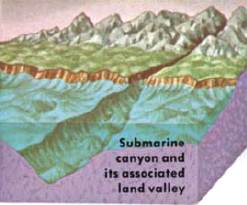

Experimental turbidity current in a laboratory tank
TURBIDITY CURRENTS are dense, flowing masses of sediment-carrying water flowing at speeds of up to 50 miles per hour. Many are probably triggered by earthquake disturbances of unconsolidated sediment on the continental shelves and slopes. The coincidence of some submarine canyons with river courses, such as those of the Hudson and Congo, has been thought to be the result of river erosion at earlier periods of lower sea level. Probably it is the result of either the presence of thicker, unstable masses of sediment near river mouths or turbidity flow from river mouths in times of flood.

COASTLINES mark the boundaries of land and sea. Although the great variety of rock types, structures, currents, tides, climate, and fluctuating sea levels produce many different types of coastlines, each can be understood as the product of three simple processes: erosion, deposition, and changing sea level.
Coastal erosion is the result of the twice-daily pounding by the sea, wearing down the margins of the land, creating coastal features, and cutting back the shoreline at a rate of several feet a year.

Coastal view of Hargrave’s Lookout, New South Wales, Australia
CLIFFS AND WAVE-CUT PLATFORMS are characteristic of shorelines undergoing erosion. Waves undercut the rocks near sea level.
CAVES are formed by erosion along a conspicuous line of weakness in a cliff, such as along joints and faults. Continuing erosion may form an arch.
BAYS AND HEADLANDS are produced by relative differences in the resistance to erosion of coastal rocks. The more resistant standout as headlands, but ultimately, the concentration of wave erosion on the headlands and deposition in the bays have a tendency to produce a straight coastline.
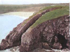
A CHANGING SEA LEVEL is represented by many features around coastlines. Within historic times, established towns have been submerged. Raised beaches and wave-cut platforms are common in many areas, rising many feet above present sea level. Far inland and high on the slopes of mountains, fossils of marine animals give further proof of older and more profound changes in sea level, reflecting major changes in the geography of the past. Submergence and emergence of coastlines modify the general features of erosion and deposition.

Drowned Valley, view from Mt. Wellington, Tasmania
EMERGENT COASTLINES are less common than the submerged. They are marked by raised beaches and cliffs, and often by an almost flat coastal plain, sloping gently seaward.
SUBMERGED COASTLINES, due to postglacial rising sea level, are indented coastlines with deep inlets and submerged glacial valleys. The “grain” of the coastline depends upon the character and structure of the rocks. In Atlantic-type coastlines, the structural trends are more or less perpendicular to the coast. In Pacific type, they are parallel to the coast.

MARINE DEPOSITION may be recognized as the dominant process where shorelines are marked by a number of familiar features. Ultimately, the balance of coastal erosion and deposition tends to produce a coastline in temporary equilibrium. Although this is more quickly formed in soft strata, it requires thousands of years in resistant rocks.

BEACHES consist of sediment sorted and transported by waves and currents. Most of the sediment is the size of sand or of gravel, but local cobble and boulder deposits are also common. Beaches vary greatly, depending upon the sediment supply, the form of the coastline, wave and current conditions, and seasonal changes. On irregular coastlines, they tend to be confined to the bays. Oblique waves and longshore currents often produce constant lateral movement of beach material. Beaches thus exist in a state of dynamic equilibrium, as a moving body of wave-washed and sorted sediment.

Interaction of river and marine deposition and erosion, Wales
OFFSHORE BARS formed of sand and pebbles are generally separated from the main shoreline by narrow lagoons. They are ancient beach deposits that are characteristic of submerged coasts. In North America, offshore bars are common along the Atlantic and Gulf coasts. They are generally parallel to existing coastlines.
SANDBARS are formed on indented coastlines by longshore drift of sediments parallel with the coast. When sediment is carried into deeper water, as in a bay, the energy of the waves or currents is reduced, and the sediment is deposited as a bar. The slower the current, the more rapidly the sediment is deposited. The bar is an elongation of the adjacent beach, partly or completely cutting off the bay. Spits are bars that extend into open water rather than into a bay. The free ends of many spits are curved landward by wave refraction. Spit growth may lead to blocking of harbors and diversion of rivers that flow into the sea, sometimes requiring dredging.

Typical cliff and beach scenery shows balance of erosion and deposition. (Dorset, England)
DELTAS (see here) are formed by rapid deposition of material carried by a river when it enters the deep water of a lake or the sea and loses its velocity. All deltas have a similar pattern of deposition and sediment distribution. Shape and size vary, depending upon local conditions.
STORM BEACHES (or berms) are formed by storms that throw gravel and boulders up above the normal high-tide level.

Wide, sandy beach with storm beach near cliffs at Lavernock, Wales
MARINE SEDIMENTS are classified in three broad categories: littoral, neritic, and deep-sea sedimentation. Littoral sediments form between high- and low-tide levels; neritic sediments accumulate on the continental shelf. These two groups of shallow-water sediments cover only about 8 percent of the ocean floor. They are made up of a variable mixture of terrigenous or land-derived debris, chemical precipitates, and organic deposits. They differ from place to place due to variations in coastlines, rivers, and changes in sea level.

In general, in shallow-water sediments, there is a direct relationship between the size of a sediment particle and the distance to which a given current will carry it, the larger particles being deposited nearer the source. This pattern is modified by the action of waves, currents, and turbidity currents.
Deep-sea sediments deposited outside the continental shelf form a layer generally less than 2,000 feet thick over the deeper parts of the ocean floor. They are much thinner and younger in age than we should predict from knowledge of present rates of sedimentation. The abyssal parts of the ocean show much more uniform sediments than the continental margins, where most terrestrial debris is deposited. Those of the bathyal zone, deposited on the continental slopes to a depth of about 12,000 feet, include muds of various kinds. The sediments of greater abyssal depths are red clays and various oozes which cover 30 percent and 47 percent of the ocean floor respectively.
CALCAREOUS OOZES are fine-medium-grained sediments that cover almost half the ocean floors. They occur down to a depth of almost 15,000 feet. Below that depth, the calcareous tests of the planktonic foraminifer Globigerina and pteropod molluscs, which form most of the sediments, are dissolved.

SILICEOUS OOZES are derived from the remains of surface-living organisms (diatoms and radiolaria) forming very slowly at great depth in the oceans. Diatom oozes are found chiefly in polar seas where predatory creatures are less common. Radiolarian ooze is most commonly found in the warm, tropical waters.
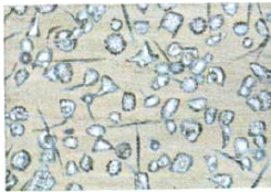
DARK RED CLAY is formed from meteoric dust and from very fine terrigenous or volcanic particles carried by the wind or in suspension in sea water. It may form as slowly as one inch every 250,000 years. It may include volcanic ash layers. Other sediments, such as manganese nodules (shown here), are present in some parts of the ocean floor.

WINDS
Winds are movements of the atmosphere brought about not only by the rotation of the earth but by unequal temperatures on the earth. The heat of the sun, the chief source of this circulation, is more concentrated in the tropics than in high latitudes. This produces vast atmospheric convection currents, having a broad, constant overall distribution that reflects the earth’s rotation. It also shows wide local variations in speed and direction due to differences in topography and other atmospheric conditions.
A major role is played by the wind in the distribution of water from the oceans to the land. Water vapor, in turn, has a blanketing effect that keeps the earth’s surface temperature higher than it would otherwise be. Wind is an agent of transport and, to a lesser extent, of erosion. In this, it resembles flowing water, but because of its much lower density (only about 1/800 that of water), it is far less effective and generally transports only the finer dust particles. Dust from volcanic explosions will often give brilliant sunsets in distant lands for many months after the explosion. Winds transport through the atmosphere comparatively large quantities of salt crystals gathered from the ocean’s surface.

WIND is most effective in transport and deposition in deserts, near shorelines, and in other places where there is a supply of dry, fine-grained, loose sediment with little vegetation to hold it together. Great Sand Dunes National Monument, shown here, is formed by deposition of wind-borne sand against mountain range.
WIND EROSION is very limited in extent and effect. It is largely confined to desert areas, but even there it is limited to a height of about 18 inches above ground level.
DESERT PLATFORMS are clean, windswept areas where pebbles may have been rolled and bounced along by the force of strong winds. Larger cobbles and boulders are left behind.
VENTIFACTS, found in deserts, are pebbles or cobbles that have developed polished surfaces and sharp edges under wind abrasion.

DESERT EROSION tends to expose bare rock surfaces, which may stand up without a cover of vegetation, as in Pakistan.


Semiarid landscape has distinctive erosional character.
WIND DEPOSITS consist of transported particles that are effectively sorted according to size because of the limited carrying capacity of the wind. Sand dunes, for example, generally consist of sand grains of more or less uniform size, which are rounded and pitted or frosted by abrasion.
Sand dunes are found in areas where there is a large supply of dry, loose, fine-grained material. Like snowdrifts, they form around local obstructions. They also migrate downwind. Their particular size and form depend upon the sand supply, the presence of vegetation, and the velocity and constancy of direction of the prevailing wind. Dunes may be transverse or longitudinal to the wind direction.
BARCHANS are crescentic dunes that often build up to 400 yards long and 100 feet high, and are formed mostly in deserts with more or less constant wind directions. They are not static and may migrate up to 60 feet per year.
The crescent paints show downwind direction. Winds also produce giant ripple marks on sand surfaces, Barchans usually are found in groups, or swarms, and may form long lines, or chains, across a plain.
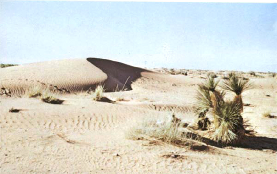
SAND-DUNE SHAPE typically has gentle windward slope and steep leeward slope, down which sand grains slide or roll. Dotted line shows how continuous movement of sand grains produces migration of whole sand dunes. Dunes take many forms. It would not be easy to compile a complete list of all the varieties. Variations in form include scalloped sides and irregularities in plan of the crest.

ANCIENT DUNE DEPOSITS, preserved in such sedimentary rocks as those of the Navajo Sandstone in Zion Canyon National Park, display aeolian bedding, sorting, and sand grain rounding similar to those of present-day dunes. Careful mapping of bedding directions reveals ancient wind directions. In this way, it has been possible to make a map of the Permian winds of southwestern United States 225 million years ago.
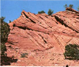
Cross-bedding, in wind-deposited sandstone, reflects its formation in ancient sand dunes, east of Echo Cliffs, Arizona,
LOESS DEPOSITS, formed of fine-grained silt, lack any bedding but often have vertical joints. Transported by wind from deserts, from dried-up flood plains, from river courses, or from glacial deposits, they are common in midwestern United States, China, Europe, and in many areas surrounding the world’s deserts and glacial out-wash areas. Loess produces fertile soils, partly because of its very high porosity. Loess is yellow or buff in color and often forms vertical cliffs. Artificial caves in easily worked loess may provide homes.

PRODUCTS OF DEPOSITION
Sedimentary rocks are generally formed from the breakdown of older rocks by weathering and the agents of erosion described in the section beginning here. A few are chemical precipitates, or organic debris. Sedimentary rocks cover about 75 percent of the earth’s surface.
CLASTIC OR DETRITAL SEDIMENTARY ROCKS are formed from the debris of preexisting rocks or organisms. The weathered rock material is generally transported before it is deposited. This movement often gives round grains. The debris is eventually laid down in horizontal layers, usually as marine deposits but sometimes as deposits from rivers, lakes, glaciers, or wind. Clastic rocks are solidified sediments.
CONGLOMERATE consists of rounded pebbles or boulders held tightly in a finer-grained matrix. The pebbles are usually of quartz at least ¼ inch or more in diameter.

SANDSTONE consists of sand-size particles, usually of quartz. It may show considerable variation in cementing minerals, in rounding and sorting of particles, and in forms of bedding.
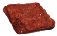
ARKOSE is a quartz-feldspar sandstone usually formed in desert areas by rapid erosion and deposition of feldspar-rich igneous rocks.

CALCARENITE consists of broken shells or other organic material and fragments from older limestones. It is deposited as sedimentary debris.

GRAYWACKE is a poorly sorted mixture of rock fragments, quartz, and feldspar fragments in a clay matrix. Often formed by turbidite flows (see here), graywacke always indicates rapid erosion and deposition under unstable conditions.

SHALE consists of very fine-grained particles of quartz and clay minerals. It is consolidated mud that has been deposited in lakes, seas, and similar environments. About 45 percent of all exposed sedimentary rocks are shales.
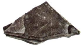
ORGANIC SEDIMENTARY ROCKS are formed from organic debris—the deposits or remains of once-living organisms (shells, corals, calcareous algae, wood, plants, bones, etc.). Although they are a form of clastic rock, organic rocks may contain more and better-preserved fossils, as they are laid down near the place where the animal or plant once lived.
CHEMICALLY FORMED SEDIMENTARY ROCKS consist of interlocking crystals precipitated from solution. They, therefore, lack the debris-cement composition of other sedimentary rocks. A decrease in pressure, an increase in temperature, or contact with new materials may cause minerals to precipitate from solution.
LIMESTONE consists chiefly of calcite from concentrated shell, coral, algae, and other debris. It may grade into dolomite, characterized by the presence of calcium and magnesium carbonate (see here). Chalk is a fine-grained limestone of minute coccoliths. Travertine is limestone precipitated by springs.

EVAPORITES are chemical precipitates, formed by evaporation in shallow, land-locked basins of water. They vary greatly in texture and composition. Rock salt, gypsum, anhydrite, and potassium salts are the most common. Important industrial minerals.

COAL is consolidated peat, formed by the decomposition of woody plant debris (see here). It is an organic rock, and plant structures may still be preserved in it. Coals grade from lignite to anthracite, which has about 95 percent carbon in it.

SEDIMENTARY ROCKS are important natural resources. Shales and limestones are used for cement, clays for ceramics; other rocks are used for road metal. Sedimentary iron ores, bauxite, and coal form the basis of much heavy industry; soil is the ultimate basis of most of our food supplies.

A typical coal mine operation
THE SIZE, SHAPE, AND SORTING of sedimentary structures within rocks may provide clues to the depositional environment that existed during their formation. Rounded, frosted, well-sorted grains, for example, indicate wind-deposited sand.
CROSS-BEDDING is a term applied to sweeping, arclike beds that lie at an acute angle to the general horizontal stratification. It is common in stream and deltaic deposits, in deeper marine waters, and in sand dunes. Cross-bedding reflects the direction of current flow.
GRADED BEDDING is due to differential settling of mineral grains, and is useful for determining the correct “way up” in folded strata. The layers of coarse rock have a sharp base and gradually grade upward into finer-grained materials.
VARVED BEDDING is a type of thin, graded bedding that has alternate laminations of coarse and fine-grained material. Especially common in glacial lake deposits, it is characteristic of seasonal deposition, each pair of varves representing a year. (See here.)
MUD CRACKS form where lake and mud deposits are dried by the sun and are preserved by burial under mud.

SCOUR-AND-FILL structures are formed by erosion and subsequent filling of valleys and channels in a river bed.

RIPPLE MARKS are produced by wind in desert sand deposits and by waves or currents in various aqueous environments.


