If there be a Paradise on earth, it is now, it is now, it is now!
—Wilfred Noyce, describing the area above NagDAADa in
Climbing the Fish’s Tail (Machhapuchhre)
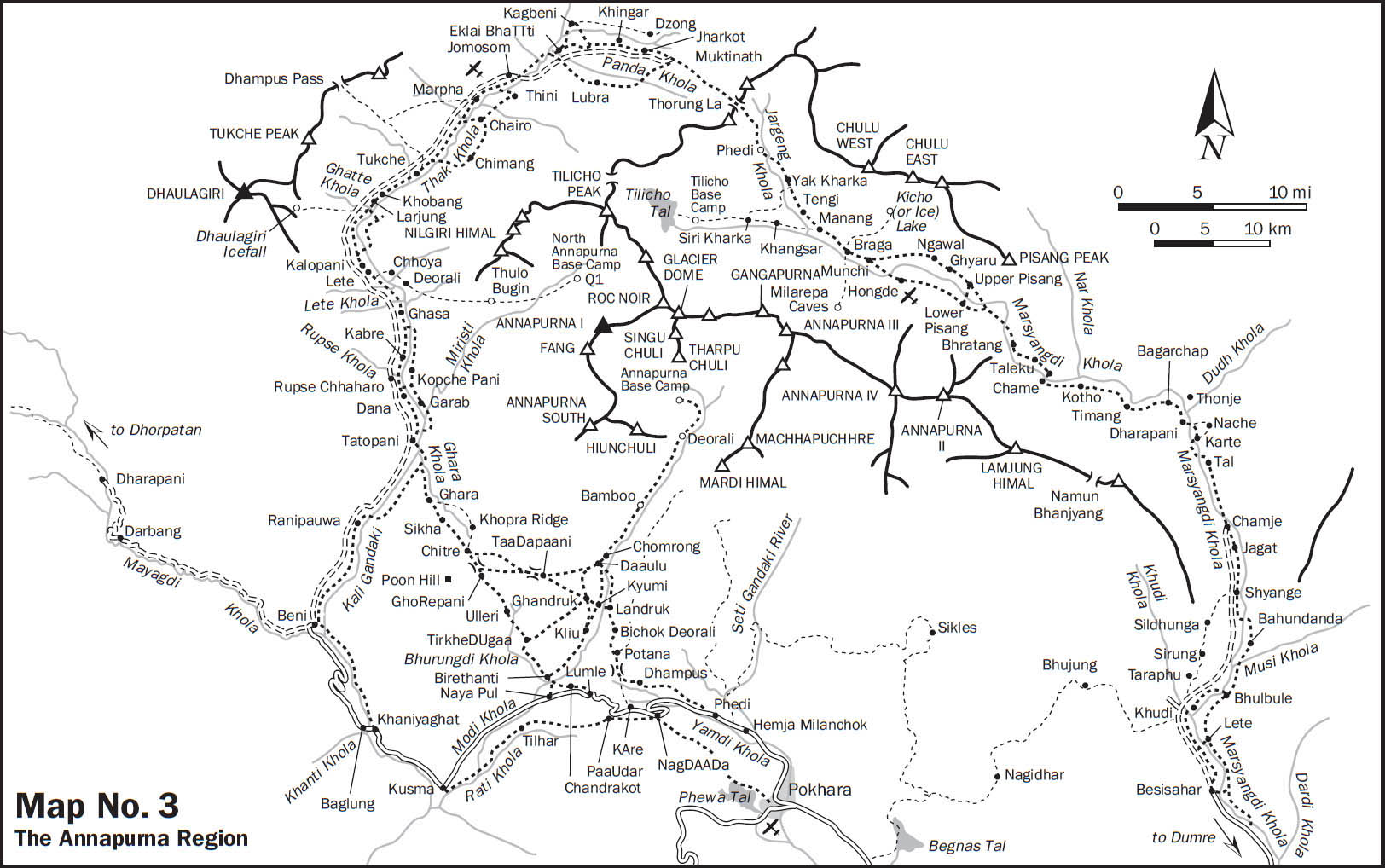
Scenic Pokhara is the usual starting point for a visit to the Annapurna Conservation Area Project (ACAP). A circuit of the Annapurna massif combines superlative mountain scenery with incredible ethnic and cultural diversity and traverses through very different ecological life zones. Despite encroachment by motor roads, this classic trek is among the world’s best and receives the most visitors of Nepal’s trekking areas, over 75,000 in 2009.
The government decided in 2005 to construct roads to both Jomosom and Manang, headquarters of their respective districts. The Annapurna Circuit was formerly over 135 miles (215 km) long, and the roads, when completed, could potentially reduce the Annapurna Circuit to around 19 miles (30 km), although variations abound and will be covered below. The road to Jomosom is already complete, barring seasonal monsoon washouts, while construction work remains on the Manang side. (An unpaved road from the Tibet Autonomous Region has also been constructed into Upper Mustang and will soon link to Jomosom as well.)
Ostensibly, the road construction was to alleviate poverty by facilitating development. However, politics played a role, and the construction has been controversial among Nepalis and foreign visitors. ACAP is under a lot of change because of these new roads, and nobody knows how it will settle out. Alternate routes are being explored away from the roads. There is genuine fear on the part of some lodge owners along the main routes of losing their livelihood. New paths have yet to be decided or prepared for tourist arrivals. Even still, it is possible to trek the circuit while avoiding the current vehicular traffic for much of the way, as will be outlined below. Often where there is a road, there are two options to follow: (1) more adventurous routes where you might have to arrange your own lodging and food in homes, or (2) the well-trodden, often jeepable routes. If you get off the main routes, be prepared for more of an adventure and to take it how it comes; be prepared for a lack of facilities and comforts, and to ask for the generosity of the local people if caught short in a village without a lodge or restaurant.
Traditionally, the Annapurna Circuit is completed in a counterclockwise direction. That is, most people start at Besisahar and follow the Marsyangdi valley to Manang before crossing to the high Thorung La over to Muktinath and the Thak Khola/Kali Gandaki valley.
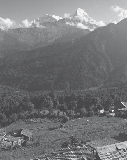
The Annapurnas viewed from Ghorepani (Photo by Tokozile Robbins)
The circuit route and facilities make the counterclockwise direction more feasible for crossing the Thorung La, as the only lodges between Muktinath and the pass (clockwise) are at Chaharu (also known as Phedi) at 13,690 feet (4172 m), whereas there are lodges up to 15,995 feet (4875 m), over 2300 feet (700 m) higher, on the Manang side and seasonal tea shops beyond. Trekkers who do not have the inclination or time to complete the whole circuit and cross Thorung La may opt for visiting one or the other of the major river valleys of the circuit, the Kali Gandaki/Thak Khola (west) and the Marsyangdi (east).
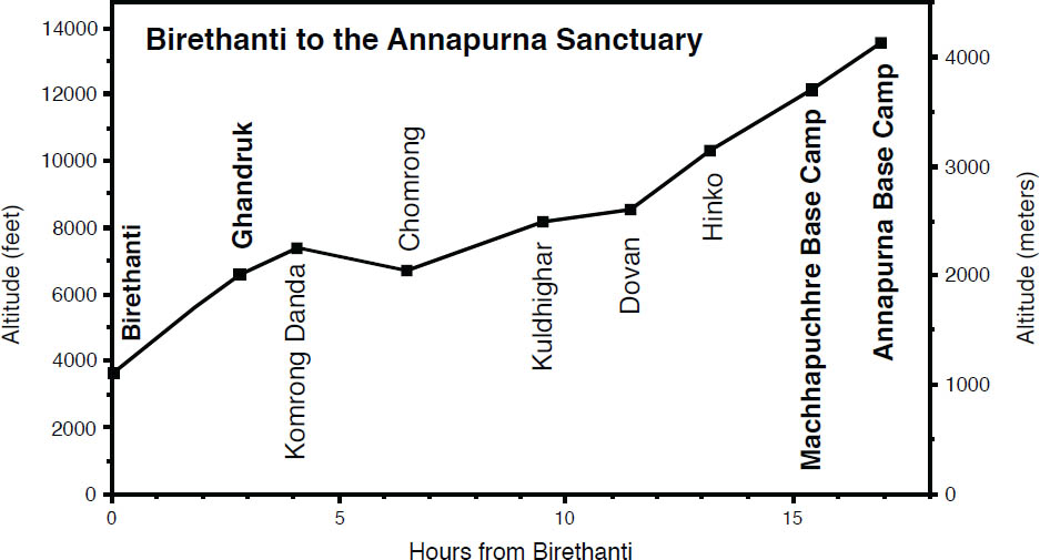
The term Annapurna Sanctuary, coined by outsiders, denotes the high basin southwest of Annapurna and the headwaters of the Modi Khola. This vast amphitheater, surrounded by Himalayan giants, can be visited as a circuit from Pokhara in less than 10 days. However, to enjoy the route and the sanctuary itself without feeling rushed, plan a few more days. This area can be easily combined with the entire Annapurna Circuit or with a trek to Jomosom that offers various link-up possibilities.
Many people take shorter journeys from Pokhara. Popular options are below; the relevant trail portions can be picked out from the descriptions that follow.
• Naya Pul to Tatopani via GhoRepani and Poon Hill, down to the Kali Gandaki and the developed hot springs at Tatopani where transportation is available to Beni and on to Pokhara (4–5 days);
• A circuit from Phedi through Landruk and Ghandruk, beautifully placed villages, and then out to Naya Pul (3 days) or on to GhoRepani and out to the road at Naya Pul or Tatopani (5 days);
• The less-traveled Gurung Heritage Trail, Thumsikot to Khudi, see Chapter 9 (4 days).
A short trek, almost all downhill, is to fly to Jomosom, perhaps paying a visit to Kagbeni and Muktinath if you first acclimatize, then walking south to Tatopani in 4 days, and then taking a vehicle to Pokhara. Those wishing to get a taste of a climb and viewpoint could visit GhoRepani and pick up the bus at Naya Pul. The section from Jomosom to Tatopani is one of the most westernized rural areas in Nepal. It has been very popular with trekkers. Well-furnished lodges and restaurants provide many tourist facilities unheard of elsewhere in Nepal. For this reason, some trekkers prefer to avoid this area, but it is very attractive to others.
Many of these treks begin at low elevations and follow valley floors. It can get very warm in late spring, so dress appropriately and try not to push yourself, especially in the first few days. Relax during the midday, try to be in the shady side of the valley in the afternoon, or carry an umbrella against sunlight.
A visit inside anywhere in the ACAP area requires an ACAP permit and TIMS card. The ACAP entry permit is available at the conservation area’s counter in Bhrikutimandap, Kathmandu, on Exhibition Marg Road, just up from Ratna Bus Park, or at the ACAP offices in Pokhara. The permit fee is 2000 NRS; that amount is doubled if the permit is purchased at a park entry point rather than beforehand. TIMS cards, $20 USD, are also available at Bhrikutimandap at a separate TIMS counter as well as at the combined ACAP/NTB office in Pokhara and at the TAAN offices (difficult to locate) in both Kathmandu and Pokhara.
Although now there is a road route, the trek from Pokhara to Jomosom on the Kali Gandaki, or the Thak Khola, as the river is called in its northern portions, is one of the easiest and most comfortable treks, in addition to being one of the most popular, in Nepal. ACAP is considering alternative routes away from the road, and we have described what is currently available, although more is to come. There is relatively little climbing, cooked food and lodging are easily available along the entire route, and the terrain is more varied than on any other trek of comparable length. Although the route passes among some of the highest mountains in the world, the scenery may not be as exciting as in, say, Khumbu. Despite the road, on this route you are still likely to encounter colorful mule caravans made musical by the tinkling of neck bells. There are several side trips out of the Kali Gandaki valley less frequented by trekkers. Though strenuous, they reward tired hikers with spectacular views and give them a glimpse of the immense scale of the valley. Muktinath, a Hindu and Buddhist pilgrimage site, is a day’s walk north of Jomosom.
Unless you plan a side trip to one of the uninhabited areas, there is no need to carry food or shelter. Lodges or hotels in most villages offer food and accommodations that are Western in style. These places are run by the Newar, Thakali, Gurung, and Magar ethnic groups.
Transportation from Kathmandu to Pokhara is available daily via several airlines or by road. To avoid backtracking, you could take a plane to or from Jomosom, although flying in is not recommended because of rapid altitude gain (Jomosom is at 9120 feet, 2780 m). It may be difficult to get a seat on a scheduled flight, as flights are often canceled due to bad weather and high winds.
Frequent buses ply the road from Pokhara all the way to Beni, a starting point that avoids the steep uphill and subsequent downhill through GhoRepani. Otherwise, you can start from the road at Naya Pul or Phedi and then pass through GhoRepani and meet the route from Beni near Tatopani with sensational views along the way. See the alternate approach in the Annapurna Sanctuary section for the route from GhoRepani to Ghandruk. Stephen’s first trek in 1969 began from the airstrip in Pokhara because there was no road, and beginning at Pokhara can still be done by first ascending to Sarangkot on the ridgeline above Pokhara, and then following the ridge to Naundanda and from there the road down to Phedi (or on to Lumle and beyond).
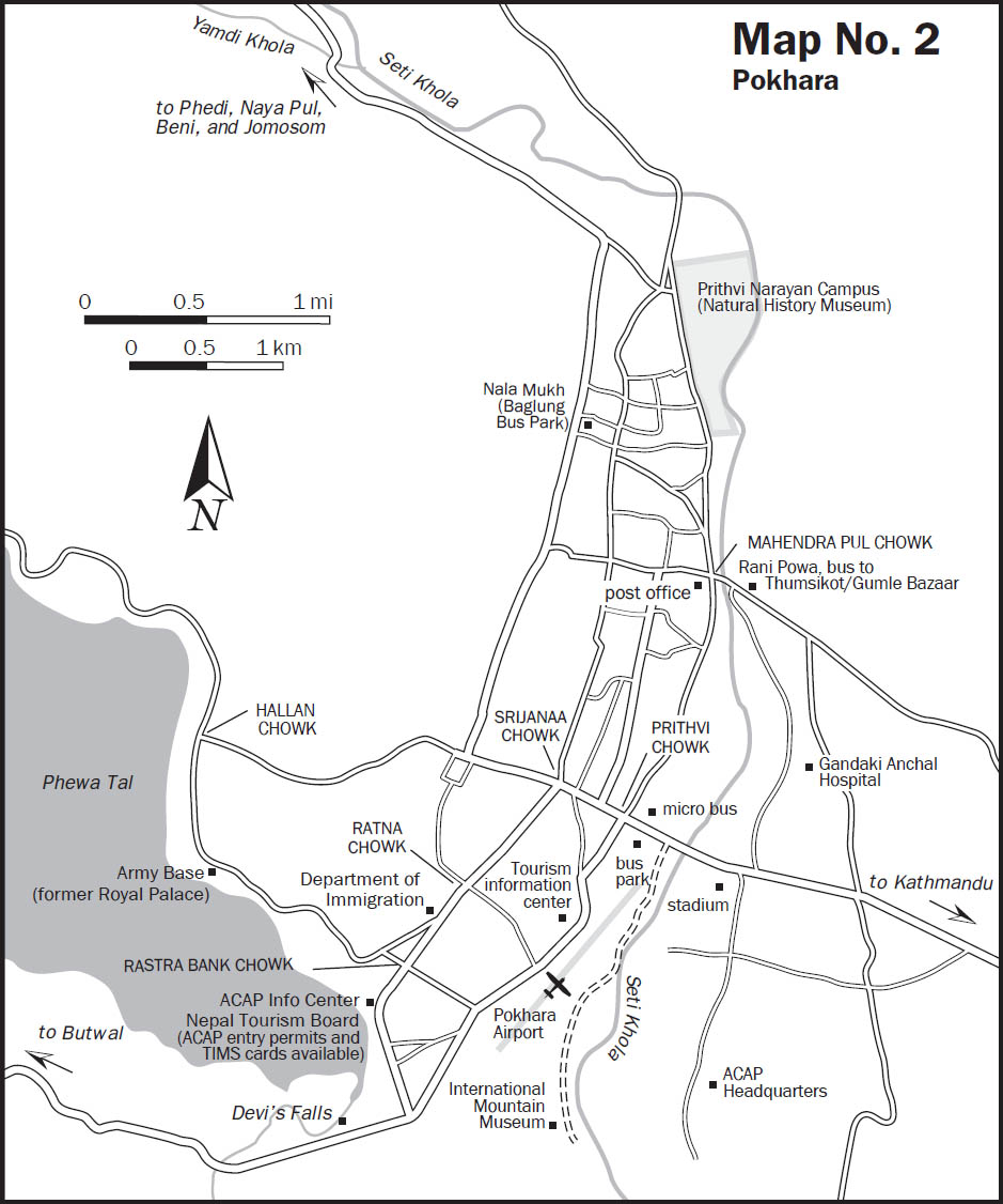
The Annapurna Conservation Area Project (ACAP) has sought to standardize facilities for trekkers and to facilitate travel north of Pokhara. Trekkers will find signboards at the entrance to many villages in this area. Developed by the ACAP, they indicate the route through the village as well as the registered establishments. There is an ACAP trekker’s information center a five- to ten-minute walk south of the Immigration Department in Pokhara, near an intersection that is known as Rastra Bank Chowk (see the map of Pokhara in chapter introduction). Trekking permits are arranged here, as well as Trekkers’ Information Management System (TIMS) cards at the Nepal Tourism Board desk in the same building. The separate, large compound of the ACAP headquarters is in a different location of Pokhara and is also a source of information for the visitor. To get there, follow the road toward Kathmandu on the way out of town. After the bridge over the Seti Gandaki River, pass a stadium on the right, and take the first avenue to the right. Follow the street for about a half hour’s walk, and the ACAP headquarter offices will be a large compound on the left-hand side of the road.
From Pokhara (2713 feet, 827 m) you can either walk, or board a bus or taxi to to the Baglung bus station (Nala Mukh or Besi Parak, different from the Bas Parak, near Mahendra Pul), at the northern end of Pokhara. Buses leave regularly.
The first place trekkers leave the road is at Phedi to travel either into the sanctuary or up to Ghandruk and over to GhoRepani and then down to Birethanti/Naya Pul for a short circuit loop, or down to Tatopani.
Another place to leave the road is near Lumle, the site of a British agricultural development project where former Gurkha soldiers are trained in farming. It has one of the highest rainfalls in Nepal. Walk from Lumle (5300 feet, 1615 m) to Chandrakot (5250 feet, 1600 m) at the west end of the ridge in 30 minutes. The views from Chandrakot are unforgettable. You will cross the Modi Khola, flowing south from between the peaks Annapurna South and Machhapuchhre, which stand before you. (The Annapurna Sanctuary, which lies upriver inside the gate formed by Machhapuchhre and Hiunchuli, the peak east of Annapurna South, is described later.) The trail descends to the Modi Khola, follows its east (left) bank southward a short distance to a suspension bridge, and crosses to the prosperous town of Birethanti (3600 feet, 1097 m), 1¼ hours from Chandrakot.
Usually, trekkers come to Birethanti by taking the bus going to Beni and getting off at Naya Pul, 30 minutes south of Birethanti. If coming from the road at Naya Pul, cross the Lumle Khola (3315 feet, 1010 m) from the bus drop-off point and walk north to the suspension bridge (3430 feet, 1045 m) just east of Birethanti. There is an ACAP check post where you register. From here, one trail heads up the Modi Khola on its west (right) bank toward the Annapurna Sanctuary. The trail to GhoRepani and on to the Kali Gandaki/Thak Khola heads west up the Bhurungdi Khola. Just up from the town by a picturesque waterfall is a cool pool on the Bhurungdi Khola. If you swim here, be sure to wear adequate clothing in order not to offend the Nepalis.
Follow the Bhurungdi Khola westward, at first through forests. Stay on its northeast (left) bank, crossing a suspension bridge (3707 feet, 1130 m) over a tributary to reach Malathanti (3793 feet, 1156 m) in 45 minutes while avoiding suspension bridges across the Bhurungdi Khola. Pass through the settlements of Lamthali, Rangai, and Sudame. Hille (5000 feet, 1485 m) is reached in 1¼ hours from Malathanti, and 10 minutes beyond is TirkheDUgaa (5175 feet, 1530 m). Farther on, the branches of the Bhurungdi Khola are crossed on several bridges (the last bridge is at 5075 feet, 1500 m). The steepest climb so far, up to picturesque Ulleri (6800 feet, 2025 m), a Magar village, takes 2 hours from Hille.
If you want to pace the climb, there are 3767 steps to ascend to Ulleri; trekker Lance Hart counted them! Note the handsome slate roofs on the village houses. Higher up, at a chautaaraa, you may still see a worn rock tablet faintly inscribed as follows: “Once, sweet, bright joy, like their lost children, an Ulleri child.” It is a memorial to eighteen-month-old Ben, the son of anthropologist John Hitchcock. Ben died here in 1961 while his father was doing fieldwork.
From Ulleri, the trail climbs steadily, enters lush oak forest, and crosses numerous small streams. It is a great place for bird-watching; however, lone trekkers have been attacked by bandits in this forest. If by yourself, hire a porter or join up with others. This caution applies all the way to Chitre on the other side of GhoRepani.
Above Ulleri you pass through Banthanti (7775 feet, 2240 m), and then Nayathanti (8550 feet, 2535 m), both with lodges and small shops. The trail emerges at GhoRepani (9250 feet, 2790 m), with a cluster of hotels and an ACAP office, below the pass some 3 hours from Ulleri. GhoRepani, meaning “horse water,” is now a far cry from the one building Stephen saw on his first trek in Nepal in 1969. Then it truly was a watering hole for the horse caravans that traveled between Pokhara and Mustang. There is public telephone service here. There are more hotels at the pass, GhoRepani Deorali (9450 feet, 2880 m). Trekkers should make certain they catch the views, either from the pass itself, which is now a swarm of lodges, or from east or west of the pass. On Stephen’s first trek here, there were no views from the pass, as it was in a dense rhododendron forest.
Poon Hill (named for the Pun clan of the Magar ethnic group), on the ridge to the west, is a popular viewpoint (10,478 feet, 3194 m). Reach the lookout in less than 1 hour. Signs point the way to Poon/Pun Hill from GhoRepani and from the pass. Views from Poon Hill of Dhaulagiri and the Kali Gandaki gorge are best in the early morning, when it can get pretty crowded. Some people enjoy the view best an hour after sunrise, when most trekkers have left. The south face of Dhaulagiri, the most impressive feature seen, was climbed first by a Japanese party in 1978 via the left buttress and by a Yugoslav team in 1981 via the eastern. The most challenging central section awaits an ascent, although a large portion of it was climbed solo in 1999 by the late Tomaž Humar, a prodigious climber from Slovenia; however, the summit of Dhaulagiri was not reached.
From the pass, a trail follows the ridge to the east to link with the trail from Ghandruk. The views to the east along the ridge are impressive as well. This route, which will be described later, offers a different return to Pokhara for those who have traveled north from Ulleri.
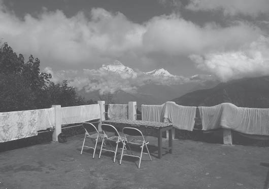
A guest house balcony offers a sensational viewpoint of the Dhaulagiri Range as well as a place to dry laundry. (Photo by Tokozile Robbins)
To continue to Thak Khola, descend through rhododendron forest, then prickly-leafed oak, to cultivated areas. Reach the right fork (7900 feet, 2407 m) of the trail to Ghandruk, with Chitre (7875 feet, 2400 m) below, and cross landslides to PhalaTe (7400 feet, 2256 m) and an ACAP checkpost, before reaching Sikha (6820 feet, 2020 m) in a notch that is 2 hours from the pass. This unforgettable descent offers views of the immense south face of Dhaulagiri to the north. There are plenty of facilities all along here. Reach Ghara (6000 feet, 1828 m), a sprawling settlement, less than 1 hour from Sikha.
 Side Trip from Chitre to Khopra Ridge. There are now facilities to make a side tour to the high ridge north of Chitre that offers sensational, close-up views of Annapurna South (23,684 feet, 7219 m), Fang Peak (25,089 feet, 7647 m), as well as Nilgiri and Dhaulagiri. Trekkers rarely make this steep detour, and there is a real danger of altitude illness, as the lodging at Khopra Ridge is at 11,975 feet (3650 m).
The route from Chitre first traverses to Swanta and follows the ridgeline to Chistibang (10,170 feet, 3100 m) to rise above the treeline, reaching the sensational lookout point of Khopra Ridge. There is a community lodge in Khopra as well as wireless Internet, thanks to the efforts of Mahabir Pun, a local resident who has provided communication service to villagers in the area with side-benefits for tourists as well. A day’s trip toward Annapurna South reveals two small glacial lakes, Kalibaraha and Khairbaraha, which are tremendously scenic pilgrimage sites. Return to the main route by retracing your steps to Chitre, or follow the ridgeline to the west and then south down to Paudar and on to the main route near Ghara. It may be possible to travel to Narchyung to the north of Tatopani and meet the route to Jomosom on the east side of the Kali Gandaki near the Miristi Khola, but it would be useful to hire a local guide.
Continue through a notch now called Durbin Danda (“binocular ridge”), and descend steeply to the south (left) bank of the Ghara Khola. Cross it on a wooden bridge (3850 feet, 1173 m) and reach the few houses called Ghara Khola above the junction of the Ghara Khola and the Kali Gandaki. As the junction of two rivers, this area is sacred and has a little temple below. The trail to Beni continues south following the Kali Gandaki downstream, but you should head upstream, cross the Kali Gandaki on a suspension bridge (3970 feet, 1210 m), and go on to Tatopani (3900 feet, 1189 m), 1½ hours from Ghara. Nilgiri is the summit in the valley floor, and the photograph of it silhouetted by porters crossing the old suspension bridge here graced the covers of the first and only coffee-table book on Nepal for decades. If you head up to Kagbeni, you will go around Nilgiri to the north side.
In September 1998, a large landslide dammed the Kali Gandaki south of Tatopani for 7 hours. Water levels rose, flooding several homes before the Kali Gandaki cut a passage through the western end and waters receded.
Tatopani, a prosperous Thakali town, takes its name (taato paani, literally “hot water”) from the hot springs located along the banks of the river, near the middle of town, just below the motor road. There are currently two pools, and a usage fee is required. Don’t foul the water with soap, even though some locals may. Wash in the effluent below the pools or in the river, rinse, and then soak in the hot water. Be discreet and modest, as the Nepalis are.
There is another hot springs located on the other, east side of the river. The built-up pool area can be seen across the river from the upper, north end of Tatopani. Reach a bridge to the other side by traveling upstream along the road for 20 minutes. Cross the suspension bridge (4200 feet, 1280 m) and return downstream on the other side for 20 minutes to the bathing area, used mainly by locals.
To escape a section of the road, after 20 minutes of following the road north from Tatopani, cross a suspension bridge (4200 feet, 1280 m) to the east side of the Kali Gandaki. Pass by a few teahouses and contour up the river, staying to the left before passing just above a school. Stay left again to cross to the north side of the Miristi Khola on a suspension bridge (4373 feet, 1333 m) about 40 minutes after crossing the Kali Gandaki. Ascend to a small plateau before descending to Patar (4396 feet, 1340 m) in 15 minutes. There are no facilities in Patar.
Beyond Patar, the trail passes through a bluff and descends to a suspension bridge in 15 minutes. Do not cross the bridge here but stay on the east bank of the Kali Gandaki and contour past a hydropower project to reach Garab (4478 feet, 1365 m) in 5 minutes, 1 hour 35 minutes from Tatopani. There are shops, and simple lodging may be available here, too. Continue contouring along the river, eventually passing another suspension bridge before ascending up to Gadpar (4823 feet, 1470 m) in 40 minutes. Ascend to the few houses of Bhalebas (5633 feet, 1717 m) in 40–45 minutes, with a grand vantage point of the waterfall across the river. There are no facilities in Bhalebas or Gadpar. Descend to reach Kopche Pani in 20–25 minutes, 1¾ hours from Garab, across the river from Rupse Chhaharo and along the east-side route described below.
THE KALI GANDAKI VALLEY—A GREAT BIOGEOGRAPHIC DIVIDE |
When trekking up the Kali Gandaki valley to the Thak Khola, you experience changes in flora and fauna that are more dramatic than anywhere else in Nepal. For example, in one day you can descend from the arid Tibetan steppe flora at Tukche through temperate coniferous forests to reach the humid subtropical zone around Tatopani. The Kali Gandaki has cut the world’s deepest river gorge right through the Himalaya. The river runs from the Tibetan plateau to the north, through almost the center of Nepal and the middle of the Himalaya. |
The valley is a biogeographic divide for Himalayan flora and fauna. Forests to the west of the valley are generally drier and have fewer plant species than eastern forests. In their field guide Birds of Nepal, the Flemings point out that the Kali Gandaki is a very distinctive break in bird distribution. Some species, such as the fire-tailed myzornis and the brown parrotbill, are restricted to the valley and farther east, while others, the cheer pheasant for instance, only breed in the valley and westward. Forests to the east of the valley are significantly richer in bird species than western forests, even taking into account that western forests are relatively poorly recorded.  |
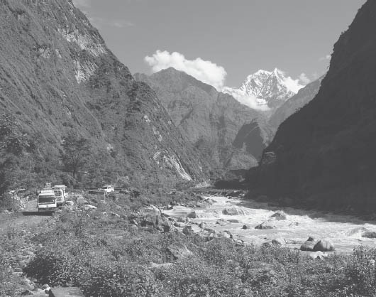
The view north from Tatopani up the Thak Khola valley includes Nilgiri as well as a road plied by buses and other vehicles. (Photo by Tokozile Robbins)
Alternatively, from Tatopani, you can simply follow the motor road on the west (right) bank of the Kali Gandaki and pass through Sukebagar to Dana (4600 feet, 1402 m) by the Ghatte Khola. This wealthy, stretched-out former customs post is reached in about 1½ hours from Tatopani. In the lower end of Dana you can see the spectacular west face of Annapurna. It took Stephen five trips before the clouds cleared enough to see it. Continue on the west (right) bank to Titar, and then climb to the few houses of Rupse Chhaharo (5350 feet, 1631 m), named after the waterfall above the bridge. Rupse Chhaharo is reached in 1¼ hours from Dana. Note the appropriate-technology water mills here.
There are two route choices here: the east (left) or the west (right) bank. The east-side trail is currently the more used and is probably safer in the monsoon, but inquire locally about conditions. Trekkers have perished, slipping on this path. The west-side route follows the road.
To follow the east-side trail between Rupse Chhaharo and Ghasa, fork right just after the bridge at the waterfall. Descend to cross the Kali Gandaki on a bridge (5360 feet, 1634 m) at a narrow point in the gorge. Head upstream, keeping close to the powerful torrent, now chocolate brown carrying sand and soil south. Reach Kopche Pani, with several small clusters of teahouses (5500 feet, 1676 m), in 30 minutes. A further 1 hour’s steep climb from Kopche Pani brings you to Pahiro Tabla (meaning “landslide place,” 6400 feet, 1897 m). As you go along, look for the old trail on the west side and the ancient pilgrim trails above it. Pilgrims traveled this dangerous route to Muktinath as long ago as 300 BCE. Along the way, you may see monkeys in the forests. In another 45 minutes, reach the suspension bridge and trail junction (6400 feet, 1910 m) 15 minutes below Ghasa. 
On the west-side route along the road, climb above the teahouses of Rupse Chhaharo to reach Kabre (5600 feet, 1750 m) in less than 30 minutes. Kabre is the northernmost village inhabited by hill castes in the Kali Gandaki valley. From Kabre, continue north along the steep cliff side to where the valley narrows spectacularly and the cascading river torrent resounds across the canyon walls. Probably the world’s steepest and deepest large gorge, the gradient to the summit of Dhaulagiri is more than 1 mile (1.6 km) vertical to 1 mile (1.6 km) horizontal (1:1.05 to be exact). The steepest part, however, is south of the line between the two summits. The east-side trail rejoins the road 2 hours from Kabre and 15 minutes south of Ghasa.
AMPHIBIANS AND REPTILES OF THE SUBTROPICAL ZONE |
| Nepali amphibians and reptiles are primarily found in the warmer tropical and subtropical zones (3300–6500 feet/1000–2000 m in the west, to 5500 feet/1700 m in the east). Over thirty-six species of amphibians, including frogs (bhyaguto), toads, newts, and a caecilian, have been recorded so far. One of the commonest is the aptly named skittering frog (Rana cyanophlyctis), which can float and skip over the water surface. The six-fingered frog (Rana hexadactyla) is the largest Nepali amphibian. Not aquatic, it is reported to feed on mice, shrews, birds, and lizards. In the breeding season it calls deep “oong-awang” throughout the night. Reptile species include crocodiles, turtles, lizards, skinks, and geckos. Snakes (sAAp, sarpa) are elusive; most are nonpoisonous. One of the commonest is the buff-striped keelback (Amphiesma stolata), which occurs in grassy areas near cultivation. It is olive-green or brown above with black spots or bars intersected with buff stripes. Lizards (chhepaaro) are more obvious and can often be seen basking in the sun on stone walls or rocks. A familiar lizard is the Himalayan rock lizard (Agama tuberculata). It is coarsely scaled, has a long tail, and is generally colored brown with black spots; breeding males have blue throats. |
It takes 30 minutes to get through Ghasa (6700 feet, 2040 m), a sprawling, flat-roofed Thakali village with an ACAP Safe Drinking Water Station. (In reverse, traveling from Ghasa to Dana, avoid the trail that heads left immediately after leaving lower Ghasa. It leads to an unused bridge and path. Instead follow the road for 15 minutes and then cross to the east bank on a suspension bridge.)
Note how remarkably the land has changed over this short stretch, as the climate becomes colder and drier. To the south, you may see lizards throughout the year, but from here northward none are seen in the cold season. Similarly, as you head north, you will encounter more pine forests and fewer broad-leaved trees. Most houses beyond here have flat roofs because there is less rainfall. The changes will be even more dramatic farther along. Be careful not to twist your ankle on the river-worn trail boulders.
To continue north from Ghasa, cross a tributary, and pass through Kaiku and the few houses of Gumaaune (literally “walking around”). There is a huge landslide scar on the east side. Reach a bridge over the Lete Khola (8000 feet, 2438 m), a tributary from the west, and cross it to a lodge. Lete (8100 feet, 2469 m), some 30 minutes beyond, is 2 hours from Ghasa. Annapurna I, the first 8000-meter peak ever climbed, can be seen to the east from Lete. Again, note the change in ecology; Lete gets 49 inches (124 mm) of rain a year, whereas a mere half day to the north, Tukche gets only 8 inches (20 mm).
A trip is described below from Lete east to the original Annapurna Base Camp. This hard-found camp was the base for the French expedition that accomplished the first ascent of an 8000-meter peak, Annapurna (26,545 feet, 8091 m), in 1950. From Lete, the route is a strenuous 5-day camping trip to substantial altitudes where food, fuel, and shelter must be carried. See “Explore: North Annapurna Base Camp” later in this chapter for more details.
Heading north, pass the police check post in the spread-out village of Lete, which then blends into Kalopani (8300 feet, 2530 m). Sunsets from Kalopani and Lete are memorable. The Cultural Thakali Museum is in Kalopani next door to the ACAP Safe Drinking Water Station.
A few minutes north of Kalopani, take the suspension bridge (8251 feet, 2515 m) over the Kali Gandaki/Thak Khola to the east side. The trail passes through Dhampu to reach Dada (8383 feet, 2555 m) in 30 minutes. A trail up to Titi village with a nearby small lake leads off from here. Continue on to KokheThAATi (8300 feet, 2530 m) in less than 10 minutes before crossing back to the west (right) bank in another 20 minutes. In less than 15 minutes more, reach the broad Ghatte/Boxe River delta. In the dry season, you can head straight across the delta with minimal wading to meet the road on the other side and follow it to reach Larjung (8400 feet, 2570 m) in 30 minutes or 1¾ hours from Kalopani. (If wading is not possible, then head up the tributary valley to a suspension bridge [8317 feet, 2535 m] over the Boxe Khola.) There is an ACAP Safe Drinking Water Station in Larjung and many walnut trees in both Larjung and Khobang.
To the west is the incredibly foreshortened summit of Dhaulagiri, almost 3.5 miles (5.5 km) higher. The temples above Larjung are where the local deities are kept for Thakali clans residing here. There is a festival honoring them every twelve years. Bhurjungkot lies to the west above Khobang and Larjung. A trail to the village heads west from the lower, southern end of Larjung, reaching Bhurjungkot in 30 minutes. A cave said to be used by Padmasambava lies a few hours north of this village.
Side Trip from Larjung to Dhaulagiri Icefall. This can be made in a long, full day trip involving 3940 feet (1200 m) of ascent with no facilities en route. To get to the trailhead, retrace your steps from Larjung, heading down the Kali Gandaki, and after 30 minutes reach the broad Ghatte/Boxe River delta. Rather than wade across the delta, head up the valley to a suspension bridge (8317 feet, 2535 m) over the Ghatte/Boxe Khola. Cross the bridge and, after a few minutes following the road downriver, you will see a trail (indicated by an ACAP sign) on the right that leads to Bhuturcho Lake, a small body of water 30 minutes above the road. However, continue following the road and just after crossing a tributary, there is an ACAP sign indicating the trail to the right leading up to Sekong Lake and on to Dhaulagiri Icefall. It may be best to hire a local guide. The area below the icefall (12,400 feet, 3780 m) can be visited in a very long day, but it’s better to camp and enjoy the sunrise and sunset. The area below the east Dhaulagiri Icefall abounds with yak pastures and was the location of the 1969 American Base Camp. At a lower altitude than Dhampus Pass, it has correspondingly less severe conditions. The views of the mountains are excellent, possibly better than at Dhampus Pass. Beware of avalanches in the vicinity of the icefall.
From Larjung, head north, cross a tributary, and in a few minutes enter the fascinating town of Khobang (8400 feet, 2580 m). The trail used to pass through a tunnel, and doors to the houses opened off it. The village was thus protected from the strong winds that blow up the valley almost every afternoon. The northern, open segment of the series of settlements is called Kanti. The dry-season path keeps closer to the river. Cross another tributary, either on a temporary bridge or upstream on a more substantial one. Tukche (8500 feet, 2591 m), an historically important town, is 1 hour beyond Khobang. There is an ACAP Safe Drinking Water Station here.
Tukche was once an important center for the trade of Nepali grain for Tibetan salt through the valley of the Thak Khola. Thakali Subbha, or customs contractors, controlled it and exacted taxes at Tukche in the summer and at Dana in the winter. The handsome architecture and great woodcarving in Tukche attests to the importance of this town. By the middle of this century competition had reduced this trade, and the enterprising Thakali turned their attention south and became more involved in business ventures around Pokhara and in the Tarai. Their spread throughout many of the trade routes in Nepal resulted in the establishment of many bhaTTi, even before trekking became popular. With the coming of foreigners, the Thakali developed hotel facilities for them, and many of their family homes have been developed into lodges. Try to find a traditional bhaTTi and sample a good Nepali meal of daal bhaat tarkaari (lentils, rice, and vegetables) or at least have such a meal in a tourist restaurant.
PHEASANTS OF THE TEMPERATE ZONE |
| Nepal is famous for its variety of Himalayan pheasants. There are six species, all of which can be seen in the Annapurna Conservation Area. Most are shy and difficult to see unless you flush them from the forest. They call frequently in spring. The Kalij pheasant (Lophura leucomelana), or kaali (length 24–27 inches, 60–68 cm), inhabits all types of forest with dense undergrowth, especially near water, and also occurs in subtropical and tropical zones. The male is mainly black with a long tail and red on the face; the female is reddish brown with a shorter tail. The Koklass pheasant (Pucrasia macrolopha, or phokraas (length 20–24 inches, 52–61 cm), inhabits oak and conifer forests from the Modi Khola valley westward. The male is dark, with a long crest and tail, black head, and white ear patch. The female is brownish, with a shorter crest and tail. It crows loudly at dawn. The satyr tragopan, or crimson-horned pheasant (Tragopan satyr), or munaal (length 23–27 inches, 59–68 cm), is found in damp oak and rhododendron forests with dense undergrowth. The male is bright red, spotted with white and with a blue wattle; the female is mottled brown. In spring, it makes a strange, mammalian “waaa” noise at dawn and dusk. |
The Thakali seem to prosper in whatever they turn to. In comparing his visits to this region twenty years apart, Stephen found the improvements impressive—water systems, latrines, more schools (indeed, functioning schools), better trails, more varieties of crops, and cleaner homes. The Thakali have always exhibited a strong ethnic group consciousness, and Thak Khola is their homeland. Many of the towns have been electrified through the installation of a mini-hydroelectric generator across and up from Khobang on the Chhokopani Khola, which produces 260 kilowatts. Visit the active gomba at the northeast end of town and tour the distillery (the first of many to the north).
A strong wind blows from the south up the valley, beginning in the late morning and lasting most of the day. This is caused when the air mass over the plateau to the north warms, rises, and creates a pressure difference. The best time to head south is in the early morning when the wind may be from the north. As you go up the valley from Tukche, notice that there is relatively little vegetation on the valley floor itself, but there are trees and forests on the walls. The valley floor is in a rain shadow due to the strong winds. When the wind is blowing, you may notice that there are no clouds over the center of the valley, but clouds do hang on the sides.
Side Trip to Dhampus Pass and Hidden Valley (visitors must be acclimatized and self-sufficient to travel into the Hidden Valley). A trail to Dhampus Pass goes up the hill to the west of the gomba (monastery) at Tukche (another trail departs from Marpha). Dhampus Pass (17,000 feet, 5182 m) connects the valley of the Thak Khola with Hidden Valley. Semiwild yak herds, snow leopards, and blue sheep might be encountered in Hidden Valley. It lies beyond the treeline and is often snowed in. Huts used for pasturing yaks can be used for shelter and cooking en route to the pass. There are no facilities at the pass. Carry food, fuel, and shelter. Temperatures below freezing can always be expected, and in the winter months the temperature drops below 0°F (–18°C). A trip to the pass is ideal for those who want a more vivid experience of being in the mountains.
Reach the pass from Tukche or Marpha by going to some yak huts (13,000 feet, 3962 m) the first day and to the pass the second. This may be too rapid an ascent for many people. If you are unprepared to spend a night at the pass, you could go up and return to the yak huts in a day. Yak yogurt is delicious—during the warm season you should try to buy some at the herders. If there is any possibility of cloudy weather, hire a local person from Tukche (or Marpha) as a guide. Once clouds settle in, it is very easy to get lost.
A recommended alternate route exists from Tukche to Thini, the village that overlooks Jomosom. This route avoids much of the road while passing through the magnificently set village of Chimang and the Tibetan refugee camp of Chairo. To take this route, about 40 minutes from Tukche cross a suspension bridge (8573 feet, 2613 m) over the Thak Khola (which is the name of the Kali Gandaki north of Ghasa). To the right, across a broad alluvial fan, is the small village of Chhokopani, believed to be a source of holy waters and religiously important to Thakalis. Instead, head left and in 25 minutes cross the Chimang Khola just upstream on a variable bridge. Ascend to the village of Chimang (9131 feet, 2783 m), surrounded by orchards, in another 20 minutes, less than 1½ hours from Tukche. There are no lodges here.
Continue on 15 minutes to where the trails from upper and lower Chimang meet. After 15–20 minutes you reach another trail junction; stay with the middle path to reach Chairo, set among tall juniper trees 45–50 minutes from Chimang. It is a Tibetan refugee camp and no boarding is available unless permission is first taken from ACAP.
To reach Marpha from Chairo, cross a bridge over the Thak Khola and head upriver for 20 minutes to Marpha (8825 feet, 2690 m) on the west bank. Otherwise, to continue avoiding the motor road, stay on the east bank from Chairo and contour before ascending steeply to pass above bluffs. Descend steeply to reach a tributary riverbed (9186 feet, 2800 m) and cross this delta in 2 hours from Chairo. Ascend past the village of Dhumbra to a ridgecrest (9498 feet, 2895 m) in 15 minutes. There is an oft-closed gomba nearby. Descend to Dhumbra Lake (9297 feet, 2834 m) in 15 more minutes. This lake is considered to be sacred, and a local lama prohibits access to its waters. Descend through the village of Samle to reach a bridge (9071 feet, 2765 m) over a tributary in 20 minutes. Ascend to the village of Thini (9383 feet, 2860 m) in 20 more minutes, some 3 hours 10 minutes from Chairo. There are no lodges here. Jomosom lies 20–25 minutes below.

Ammonite fossils or shaligram can be found in the area north of Jomosom and are highly prized by pilgrims as a symbol of the Hindu deity Vishnu. (Photo by Tokozile Robbins)
Rather than the alternate route outlined above, most people will stay on the west bank from Tukche all the way to reach Marpha (8825 feet, 2690 m) in 1½ hours. About 15 minutes before Marpha, pass by the Marpha Agricultural Farm, which has introduced many of the new crops you see around. Marpha, a charming town, has a fine sewer system—a series of canals flowing down the streets. There are plenty of choices for accommodation and food here, especially given the variety of fruits and vegetables available. Some of the hotels here, and also in Jomosom, advertise pony rides as far as Muktinath. Visit the new large gomba in the center of town. There is an ACAP Safe Drinking Water Station here, too. Dhampus Pass can also be reached from Marpha.
To continue upstream, leave the town through the chorten and cross first a tributary and then the Pongkyu Khola, another alluvial fan, with a water mill, that flows from the west. Along the trail you will see willow plantations, part of a reforestation project. The town of Syang is beyond, and its monastery is up the hill a bit farther. On certain days during late October to early December, monks stage dance festivals in the gomba of Marpha, Syang, and Tukche that are somewhat similar to the Mani-rimdu festivals of Solu–Khumbu. Consider a side trip east across the river to the gomba on the hillock with its commanding views of the valley.
Cross a tributary farther up the valley, and reach Jomosom (8900 feet, 2780 m), the capital for the Mustang District, 1½ hours from Marpha. There are many facilities here and an ACAP Safe Drinking Water Station and ACAP Information Center. There is an airfield here with scheduled service to Kathmandu, but because of the erratic winds service can be unreliable. Winter winds regularly reach 30 to 40 knots, with gusts to 70! If you fly in and head upvalley to rarefied air, beware of altitude illness. Other attractions include banks, a hospital, rather luxurious accommodations and food, climbing cliffs with a welcome sign, and, of course, a police check post. An ecomuseum has opened at the southern end of town and has informative displays. This town has prospered immensely over the years and has expanded to both sides of the river to provide space for the many government employees and offices. Pony caravans used to bring food to Jomosom to feed the bureaucracy but are being replaced by vehicular transport.
The countryside to the north is very arid, not unlike the Tibetan plateau farther north. To the south, Dhaulagiri impressively guards the Thak Khola valley. It is much less foreshortened than at Larjung. To the east, across the river on a shelf of land, is the traditional town of Thini (9500 feet, 2897 m), reached in 30 minutes from Jomosom. The inhabitants are technically not Buddhists (though they may say otherwise) but followers of Bon-po, the ancient religion that antedated Tibetan Buddhism.
Up the valley east of Thini is Tilicho Pass and Tilicho Tal. The latter, at 16,140 feet (4919 m), is a high, spectacular lake. It is better to access this area from the west not only because the trail is clearer and there are facilites en route on that side but because you start higher and are more likely to be acclimatized. Additionally, a Nepali army camp on this side of the pass, used for mountain warfare training, might restrict some of the route. You might have noticed their “R&R” facilities in Jomosom.
To continue on to Kagbeni and Muktinath, travel on the east (true left) side of the river. The perennial high wind gusts strongly down the riverbed, which can be half a mile wide here; sunglasses or other eyewear and a mask or bandanna to cover the nose and mouth can be useful to protect against airborne dust particles. In 1½ hours reach the trail junction of Eklai BhaTTi (also known as Chyancha-Lhrenba) at 9186 feet (2800 m). Eklai BhaTTi means “lonely inn,” which bespeaks a former time as there are now several lodges. If traveling to Kagbeni, the suspension bridge just south of Eklai BhaTTi leads to a west bank route that avoids a section of the road. Another alternative to following the road is to head east up the Panda Khola valley (15 minutes south of Eklai BhaTTi) to Lubra. The route from Lubra to Muktinath is described below in reverse.
From Eklai BhaTTi, the route to the left continues up the river to the captivating village of Kagbeni (9383 feet, 2860 m) in just over 30 minutes, while the right ascends out of the valley and heads more directly to Muktinath. The right branch reaches the junction (10,350 feet, 3155 m) of the trail from Kagbeni to Muktinath in 1¼–1½ hours.
Muktinath, located in a poplar grove, is a sacred shrine and pilgrimage site for Hindus and Buddhists. The Mahabharata, the ancient Hindu epic written about 300 BCE, mentions Muktinath as Shaligrama because of its ammonite fossils called shaligram. Brahma, the creator, made an offering here by lighting a fire on water. You can see this miracle (burning natural gas) in a small Buddhist shrine (gomba) below the main Hindu temple (mandir). Many people from Mustang and other areas come to sell handicrafts to the pilgrims. Some sell the shaligram, the mollusk fossil dating from a period roughly 140 to 165 million years ago before the uplifting of the Himalaya. These objects, treasured for worship by Hindus, are said to represent several deities, principally those associated with Vishnu, the Lord of Salvation. You are apt to find them along the flats north of Jomosom and for sale in Baudha, Kathmandu. You are not allowed to export them, however. |
Hindus named the site Muktichhetra, meaning “place of salvation (mukti),” because they believed that bathing there gives salvation after death. Springs are piped into 108 brass water spouts in the shape of boars’ heads near the temple dedicated to Vishnu, the focal point for Hindus. The boar was the third incarnation of Vishnu. Because Buddha was the ninth avatar, the Hindus tolerate the Buddhists here. The Buddhists consider the image of Vishnu in this typically Newar-style temple as the Bodhisattva Avalokiteshwara. Vishnu is in the shape of an icon as well as a large ammonite fossil. The same fossil image is worshiped by Buddhists as Gawa Jogpa, the “serpent deity.” |
The miraculous fire revered by Buddhists and Hindus burns on water, stones, and earth, and is inside the Jwala Mai Temple (also called the Salamebar Dolamebar Gomba or Mebar Lhakang Gomba), south of the police check post. Natural gas jets burn in small recesses curtained under the altar to Avalokiteshwara. On the left burns the earth, in the middle water, and on the right the stone. One flame has died out; only two remain lighted. Sherpas and Buddhist porters with you may ask you for a bottle to take some of the “water that burns” with them. It is traditional to leave a small offering of money. |
| Padmasambhava, who brought Buddhism to Tibet in the eighth century, is believed to have meditated here. His “footprints” are on a rock in the northwest corner of this sacred place. On their way to Tibet, the eighty-four siddha (“great magicians”) left their pilgrim staffs, which grew into the poplars at the site. You will find many old chorten and temples cared for by Nyingmapa nuns or old women from the nearby villages. A full moon is an especially auspicious time to visit Muktinath. In the full moon of August–September, thousands of pilgrims arrive. |
The name Kagbeni aptly reflects the town’s character—kak means “blockade” in the local dialect and beni means “junction of two rivers”—and this citadel does effectively block the valley. River junctions are often considered especially sacred to the people living nearby. Since the town is at the confluence of trails from the north, south, east, and west, the ancient king who sat here could control and tax the exchange of grain from the south and wool and salt from the north. The ruins of his palace, which can still be seen, are a reminder of the ancient kingdoms that predated the unification of Nepal. Some scholars believe the family that ruled here was related to the ancient kings of Jumla. The Sakyapa monastery here charges an entry fee for a visit. You may see two large terra-cotta images of the protector deities of the town—a male at the north end and the remains of a female at the south. This mingling of old animistic beliefs with those of the more developed religions is common in Nepal.
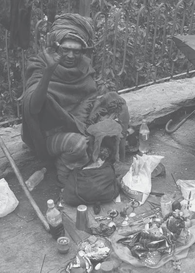
A mendicant fakir’s offerings (Photo by Tokozile Robbins)
People here call themselves Gurung but are clearly not the same as the Gurung to the south. People from Tibet who have settled in Nepal often call themselves Gurung to facilitate assimilation.
The impressive folding of the cliffs west of town illustrates the powerful forces of orogeny (discussed in Chapter 1’s geology section). There is a viewpoint called Sher Dhak several hundred meters above on the opposite side of the river. It involves a steep scramble up loose rock. From Kagbeni, you can just make out the crest of Thorung La up the valley to the east of town, with Kagbeni visible from the pass, too. There is an ACAP Safe Drinking Water Station as well as a police check post in Kagbeni, at the northern limit for trekkers.
North of Kagbeni is the Upper Mustang restricted area and the kingdom of Lo. Permits to enter can be obtained at the Immigration Office in Pokhara or Kathmandu; the cost is $500 USD per person for the first 10 days and $50 USD per day thereafter. Additionally, the trip must be guided and arranged through a registered trekking company. However, it is possible, without a restricted area permit, to visit the fascinating village of Tiri a short distance north on the opposite (west) bank of the Kali Gandaki. A road is being built to Tiri (and beyond); to hike there, from the lower end of Kagbeni, cross the bridge (9334 feet, 2845 m) to the true right/west bank of the Thak Khola and traverse north. Reach Tiri (9439 feet, 2877 m), a village surrounded by walled orchards, in 25 minutes. A gomba is perched above town. Continuing north of Tiri is restricted.
To travel to Muktinath from Kagbeni, head up from the Jhong Khola, the tributary from the east, following the road for the most part, with some sections of trail away from the road.
Continue east, noting the caves on the north side of the valley. So ancient are these caves that no one remembers if they were used by hermits or troglodytes. On a clear day, the walk can be ethereal, as the dry valley sparkles and the north wall seems suspended close to you. Climb to Khingar (11,190 feet, 3410 m) in 2 hours; the old part of town is north of the trail. Continue to Jharkot (11,715 feet, 3570 m) in 40–45 minutes more, a crumbling but still impressive fortress perched on a ridge. Jharkot, called Dzar by Tibetans, is believed to have been the home of the ruling house of this valley. Note how some houses around the ruins of the fort are made of blocks of earth.
Go on to what is now called Muktinath, also known as Ranipawa (12,047 feet, 3672 m), with a large rest house for pilgrims, many hotels, a police check post, and an ACAP visitor center office you should visit to register your name. The office is 30–40 minutes from Jharkot. If your intention is to cross the Thorung La from this side, then check with the ACAP information center here, as they may advise you against proceeding in marginal conditions.
Across the valley you can see the extensive ruins of Dzong (“castle” in Tibetan) and the town built around it, the original seat of the king of this valley. Consider a side trip to that side of the valley, outlined below.
The wall-ensconced compound of the holy shrine of Muktinath is less than 15 minutes from the ACAP center. Dhaulagiri (26,795 feet, 8167 m) looms impressively to the south. It was first climbed from the north, the view you see here, by a German expedition in 1960. The Muktinath Foundation International supports the interfaith aspect of the region and has a website, www.muktinath.org.
To the east is Thorung La (17,700 feet, 5416 m), which leads to Manang and the eastern half of the Annapurna Circuit.
Crossing the pass from Muktinath to Manang is more difficult than crossing in the other direction. The only lodges between Muktinath and the pass (clockwise) are at Chaharu (also known as Phedi) at 13,687 feet (4172 m), whereas there are lodges up to 15,990 feet (4875 m) on the Manang side and seasonal tea shops beyond. It is a very long day to ascend from Chaharu to the pass and then to descend to facilities on the other side. Additionally, in the dry season there are few if any suitable campsites with water on this side of the pass.
Altitude illness may jeopardize those who are unacclimatized. Crossing from Manang, on the other hand, is easier because of the comparatively long time spent at high altitudes before approaching the pass. Most people start at Besisahar and follow the Marsyangdi valley to Manang before crossing to the high Thorung La over to Muktinath and the Kali Gandaki/Thak Khola valley. The pass is often crossed from Muktinath, but it certainly is more difficult and hazardous. Under no condition should you ascend from either direction unless the entire party, including porters, is well equipped to camp in snow should a storm arise. The trail descriptions for the Manang to Muktinath crossing are given with the Manang section later in this chapter.
Side Trip from Muktinath to Chaungar, Dzong, and Beyond. A short excursion from Muktinath across the valley to the beautiful villages of Chaungar and Dzong (Jhong) provides a glimpse of life outside the tourist areas. This trip can be made out and back on the same path, less than 30 minutes each way. Alternatively, it can be made into longer excursions as the following three circuit routes: crossing the valley from Dzong to Jharkot and back to Muktinath (2½-hour loop), crossing the valley from Puthak to Khingar and returning to Muktinath (3½–4 hours), or continuing all the way to Kagbeni on that side of the valley (3½ hours) and returning along the road. All of the above will be described.
From the upper end of Muktinath/Ranipawa, proceed north to Chaungar (12,110 feet, 3692 m), reached in an easy 25 minutes. There are no facilities in Chaungar, but there is lodging in Dzong, which lies down the valley from Chaungar. Descend from Chaungar to cross a suspension bridge (11,920 feet, 3632 m) to the west bank of a tributary and reach Dzong (11,750 feet, 3580 m) in under 30 minutes. This village was the seat of an ancient regime, and the remains of the old castle can be seen along the crest along with a gomba above which can be visited for a fee.
From Dzong you can retrace your steps to Muktinath, or complete a loop back to Muktinath by way of Jharkot across the valley. For the latter, descend through a grove of pipal trees to cross the Jhong Khola on a steel bridge (11,290 feet, 3440 m) in 20 minutes. Ascend through more pipal trees on the other side to the circuit trail just below Jharkot in 30 more minutes.
Otherwise, to continue down the valley, reach the village of Puthak (11,290 feet, 3440 m) in 20 minutes from Dzong. From Puthak, there is a route to link with Khingar (11,190 feet, 3410 m), across the valley to the southwest, in under an hour. This involves a steep descent to the Jhong Khola (10,780 feet, 3285 m) and then a steep ascent. However, check first locally to see if the bridge is operational.
If you would like to continue on down the valley, it is also possible to reach Kagbeni from Puthak along the motor road on this north side of the valley. It is a long and desolate stretch on what locals refer to as The Muktinath Ring Road; however, this road receives less traffic than the road on the opposite side of the valley. To head to Kagbeni on this side, 15 minutes below Puthak cross a suspension bridge (11,100 feet, 3382 m). Kagbeni is 2 hours from this bridge, with no facilities or water available along the way.
To return, follow the reverse of the trail descriptions for the trek from Pokhara to Muktinath, or follow the alternate route from Muktinath to Jomosom via pleasant Lubra village. This latter route avoids a large section of the motor road by heading over the high ridge to the southwest of Muktinath and descending to the Panda Khola valley, with a visit to the picturesque hamlet of Lubra. It involves a steep climb and steep descent but avoids the annoyance of vehicles for at least part of the way to Jomosom and meets the usual route south of Eklai BhatTTi. Check first with the ACAP information Center on the availability of bridges over the Panda Khola and fill up water in Muktinath, as there may not be another chance until Lubra, 3¼ hours away.
Buckwheat fields in the hamlet of Lubra along an alternate route between Jomosom and Muktinath (Photo by Tokozile Robbins)
Find the trail as it branches to the left from the road as you head out of the lower (western) end of Muktinath. In 20 minutes stay right at a trail junction. Stay right again 25 minutes beyond and ascend to reach a saddle (12,530 feet, 3820 m) in 30 more minutes, 1¼ hours from Muktinath. Contour shortly before descending steeply into the Panda Khola valley. Reach the riverbed (10,040 feet, 3060 m) in 1½ hours from the saddle.
The trail through the riverbed at the valley floor may be faint and is of variable condition; wading might be necessary depending on the season. Either cross a bridge that ACAP has planned to build to meet a trail on the other side of the valley from where you descended, or travel downstream along the valley floor to a seasonal bridge. Reach Lubra (9859 feet, 3005 m) in 30 more minutes. There are no tourist facilities here, but there are two (rarely encountered) monasteries of the Bon religion as well as a boarding school situated above the village. Across the Panda Khola from the village, meditation caves can be seen.
To continue on to Jomosom from Lubra, head down the valley. Reach a suspension bridge (9711 feet, 2960 m) in 15 minutes. Do not cross here but stay on the south side and traverse down to the valley floor (9547 feet, 2910) in another 15 minutes. Reach the Kali Gandaki valley (12,450 feet, 3795 m) in 40 minutes. Head left/south here to Jomosom, a further 1¼ hours away (2¼–2½ hours from Lubra).
This route from the Kali Gandaki valley to the original Annapurna Base Camp was discovered by the 1950 French Expedition that summited Annapurna led by Maurice Herzog. The French first tried to climb Dhaulagiri but found it beyond their capabilities and instead tried to find a way to the base of Annapurna. They had difficulty getting there from the Kali Gandaki, and the route still has a bad reputation. It is seldom used except by shepherds and mountaineering expeditions. However, in the relatively snow-free early fall and late spring, the route is neither very difficult nor dangerous. However, the trail is often indistinct and traverses steep grassy slopes. From Lete, it is a strenuous 5-day camping trip to substantial altitudes where food, fuel, and shelter must be carried. At certain times of the year, snow can make the trip almost impossible. Parties should be prepared for cold at any time of the year. It is always best to have someone along who is familiar with the route. Porters do not like this trail, but it is certainly no worse than little-used trails in many other areas of mountain wilderness.
YARTUNG FESTIVAL |
| At about the same time as the major pilgrimage (Janai Purnimaa) to Muktinath in the full moon of August–September, local Tibetan villagers of the valley hold a great end of summer festival called Yartung—a time of horse racing, dancing, gambling, and general merriment. This is held on the race grounds of Ranipauwa, adjacent to the Muktinath pilgrimage site in the Mustang District. BhoTiya people from all over Bargee (the Muktinath or Dzong river valley) and Lo-Manthang (upper Mustang), and some from Manang (east of Mustang), Lamjung (southeast), and Dolpo (west), attend. The men of BaragaaU region compete in a day of horse racing, and other games. It is a raucous occasion spiced by drinking and gambling in tents set up on the hills around the small community below Muktinath. The day begins with processions of laymen and monks in colorful attire, some riding equally decorated horses, from each of the surrounding villages. The monks lead the processions to circle the Muktinath shrine, and women perform purification rites at the temple’s 108 water spouts. Yartung signals the return from the highlands of the animals, which are pastured in the lower valleys during the coming winter. Yartung annually attracts the majority of BhoTiya people from throughout upper Thak Khola, northern Mustang, and neighboring Manang District (over Thorung La). The participants wear their traditional ethnic dress. |
The views along the way are supreme. As the trail climbs steeply out of the Kali Gandaki valley, the incredible gorge becomes more and more impressive. The views of Dhaulagiri and Annapurna from the crest of the ridge separating the Kali Gandaki from the Miristi Khola are breathtaking. From this perch (14,000 feet, 4267 m), some 7000 feet (2134 m) above the valley floor, you can appreciate just how high these mountains are. From the foreshortened view from Kalopani, it is hard to believe that Dhaulagiri is the sixth highest mountain in the world. If you venture beyond the base camp toward Camp One, on the north side of Annapurna, you can appreciate the impressive features of that side of the mountain.
You will want to get provisions in Lete for onward travel. There is a tea shop in Chhoya, but it is best to stock up in Lete for at least 5 days of self-sufficient travel. You might be able to hire someone from Chhoya to show the way. In times of high water, it may not be possible to cross the Miristi Khola and reach the base camp without building a bridge, an undertaking most trekkers prefer to avoid. If a recent expedition has been on Annapurna, the chance of finding a usable bridge is good. Check beforehand to find out if there has been a recent expedition. In low water, the river can be forded with some difficulty downstream.
If you are coming from the south, turn right off the road 20 minutes aft er crossing the Lete Khola on a suspension bridge. In 10 minutes more cross the tumultuous Kali Gandaki on a suspension bridge (7890 feet, 2405 m) to reach Chhoya (8000 feet, 2415 m). If you are coming from the north, across from the Primary Health Center in upper Lete, take a left fork. This left fork takes you through a beautiful pine forest before you descend slightly in 20 minutes to the same suspension bridge to Chhoya.
From Chhoya the right (east) fork heads to North Annapurna Base Camp via Jhipra Deorali. The left fork heads to Taglung, Kunjo, and on to Titi village/lake. To head to North Annapurna Base Camp, cross the delta of the Polje Khola and ascend to the few houses of Poljedanda (8175 feet, 2492 m). Then turn right and head southeast to a few more houses of Jhipra Deorali (8275 feet, 2522 m) 30 minutes from Chhoya. This is the last village on the route. Here the trail forks left and you contour above fields to enter the valley of the Tangdung or Bhutra Khola, a little more than 30 minutes later. Contour below a small waterfall of a tributary to the main river (8075 feet, 2461 m) after a short, steep descent through forest, 1¼ hours from Deorali. There should be a bridge here unless it has been washed out during the monsoon. Fill up all your water containers, as you may not get another chance during the next day.
The next section of the trail is exceptionally steep. There are few suitable campsites until near the end of the climb. There are occasional vistas to inspire the weary. In 2–2½ hours, reach a saddle called Kal Ghiu (11,000 feet, 3383 m), although some trekking groups call this place Jungle Camp. Camping is possible here if you can find water down the other side of the saddle. Keep close to the crest of the ridge as you pass several notches. Enjoy the rhododendrons in bloom in the spring. After keeping to the southeast side of the ridge and leaving the forest, the trail becomes fainter, reaches a minor ridge crest (12,600 feet, 3840 m), and crosses over to the northwest side. Keep climbing to a prominent notch with a chorten (13,350 feet, 4069 m), some 2 hours from Kal Ghiu. The views of Dhaulagiri are unforgettable.
The slope eases off now and continues over more moderate grazing slopes to a place near a ridge crest called Sano Bugin (13,950 feet, 4252 m), where herders stay during the monsoon. There are rock walls here that the herders convert to shelters with the use of bamboo mats. If there is no snow to melt, water may be difficult to obtain. The gigantic west face of Annapurna, first climbed by Reinhold Messner in 1985, is before you. Head north along the ridge crest, or on the west side. The trail is marked with slabs of rock standing on end. In 1 hour, reach another ridge crest (14,375 feet, 4382 m) and cross to the southeast side of the ridge. This may be the “passage du avril 27” that Herzog’s expedition discovered in order to get to the base of Annapurna. You are now in the drainage area of the Miristi Khola, the river that enters the Kali Gandaki above Tatopani.
Continue contouring for a few minutes to Th ulo Bugin (14,300 feet, 4359 m), where seasonal herders stay. There is a small shrine here. Contour, crossing several tributaries of the Hum Khola, a tributary of the Miristi. The last stream (13,375 feet, 4077 m), reached in 30 minutes, is a little tricky to cross. Climb on, at first gradually, then more steeply, to reach a flat area sometimes called Bal Khola (14,650 feet, 4465 m) in 1¾ hours. Camp here, for there are few other suitable places until the river is reached. The west face of Annapurna looms before you. Local people do not venture much beyond here in their tending of sheep and goats.
Descend and round a ridge crest to the canyon of the Miristi Khola proper. The river is almost a mile below you, yet its roar can be heard. Continue on steep grassy slopes and pass an overhanging rock (14,075 feet, 4290 m) suitable for camping, 45 minutes from the high point. Descend more steeply on grass, cross a stream, and go down into shrubbery until it appears that a 1000-foot (300-m) cliff will block the way to the valley floor. The trail heads west to a break in the rock wall and descends through the break to the river (11,500 feet, 3505 m) 1½ hours from the overhanging rock. The impressive gorge at the bottom gives a feeling of isolation. Head upstream on the northwest (right) bank. The dense shrubs may make travel difficult. There are campsites by some sand near a widening in the river (11,575 feet, 3528 m), where it may be possible to ford in low water. Otherwise, head upstream for 10 minutes to a narrowing where there may be a bridge. Cross the river, if possible, and camp on the other side if it is late.
Once on the southeast (left) bank of the Miristi Khola, follow the trail upstream. The vegetation soon disappears as altitude and erosion increase. The trail becomes indistinct in the moraine. As the valley opens up, bear right to the east and leave the river bottom to climb the moraine to a vague shelf. Continue beyond to a small glacial lake in the terminal moraine of the North Annapurna Glacier. Cross its outflow to the right and climb the lateral moraine to the left. There are views of the Nilgiri to the west. The base camp for the various attempts to climb Annapurna from the north is on a flat shelf of land (14,300 feet, 4359 m) to the north of the glacier. There is a steep drop-off to the glacier valley to the south and east. The base camp is reached in 3–4 hours from the crossing of the Miristi Khola. Annapurna (26,545 feet, 8091 m) was the first 8000-m peak to be climbed, in 1950, by the French from this side.
The view of Annapurna I from the base camp is minimal. Better views can be obtained by contouring and climbing to the east to a grassy knoll from which much of the north face can be seen. You could also proceed toward Camp I by dropping from the shelf and climbing along the lateral moraine of the glacier to 16,000 feet (4877 m). Exploratory and climbing journeys will suggest themselves to those with experience. The Great Barrier, an impressive wall of mountains to the north, separates you from Tilicho Tal. Be sure to take enough food to stay awhile and enjoy this unforgettable area.
The subtropical zone is considered to be (3300–6500 feet/1000–2000 m in the west, to 5500 feet/1700 m in the east). |
Birds of prey either kill other animals or feed on their carcasses. Nepal has over seventy species, including twenty-one owls. The Egyptian vulture (Neophron percnopterus, length 24 inches, 60 cm) is a familiar small vulture around villages. It has a wedge-shaped tail. The adult is white with black flight feathers and yellow head (immature is brownish). It also occurs in tropical and temperate zones. The steppe eagle (Aquila nipalensis, length 29–32 inches, 74 to 81 cm) is a large eagle with long, broad wings and medium-long tail. From below, while in flight, it looks dark brown with one or two white wing bars across the undersides of its wings. It is a common winter visitor between September and April and occurs from tropical to alpine zones. |
Its call monotonously repeated all day in spring and summer, the barbet usually remains hidden in tree tops. The blue-throated barbet (Megalaima asiatica, length 9 inches, 22 cm), green with a blue throat and face and red forehead, makes a loud “chuperup.” It also occurs in tropical and temperate zones. The coppersmith (or crimson-breasted) barbet (Megalaima haemacephala, length 5½ inches, 14 cm), greenish with yellow throat and reddish breast, makes a metallic note said to resemble a coppersmith beating on metal. It also occurs in the tropical zone. The Indian cuckoo, or kaphal pakyo (Cuculus micropterus, length 13 inches, 33 cm), like several other cuckoo species, is grayish above and on the throat, with the rest of the underparts barred black and white. It occurs in tropical and temperate zones. Its bubbling call sounds like “one more bottle.” It calls all night, as does the common hawk cuckoo or brain-fever bird (Hierococcyx varius, length 13 ½ inches, 34 cm), which is gray above and mottled or barred brown below. It occurs in the tropical zone. Calls start slowly and accelerate to a high pitch. |
Nepal has six species of minivets. These are long-tailed, brightly colored arboreal birds. Long-tailed minivet, or Ranichara (Pericrocotus ethologus, length 7 inches, 18 cm) males are red and black, females yellow and black. Flocks often perch on treetops and twitter to each other as they fly from tree to tree. They occur in the temperate zone. |
The Asian magpie robin (Copsychus saularis, length 7½ inches, 19 cm) is a long-tailed, black-and-white robin. The male is black above, on throat and breast, and rest of underparts; the wing bar and outer tail coverts are white. In the female, black is replaced by gray. Common in gardens, it has a sweet song of short, repeated phrases. |
| The spiny babbler (Turdoides nipalensis, length 11 ½ inches, 24 cm) is Nepal’s only endemic bird. It is very secretive and rarely seen but fairly common in thick scrub. Grayish brown and streaked, with a long tail, it also occurs in the temperate zone. |
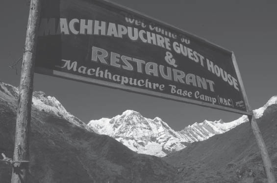
The term Annapurna Sanctuary, coined by outsiders, denotes the high basin southwest of Annapurna and the headwaters of the Modi Khola. This vast amphitheater, surrounded by Himalayan giants, was explored by Jimmy Roberts in 1956 and brought to the attention of the Western world by the British Expedition to Machhapuchhre in 1957. The presence of the gigantic mountains named for the goddesses Anna-purna and Gangapurna, important figures in Hindu myth and folklore, justify calling it a sanctuary. Its gate, the deep gorge between the peaks Hiunchuli and Machhapuchhre, marks a natural division between the dense rain forest and bamboo jungle of the narrow Modi Khola valley and the scattered summits and immense walls of the mountain fortress inside. This sanctuary area is also referred to as the Annapurna Base Camp and the Machhapuchhre Base Camp.
Trekking possibilities are varied. Those without time to head up the Kali Gandaki river, also known as Thak Khola, can make a circuit from Pokhara into the Annapurna Sanctuary in less than 10 days, with little backtracking. However, to enjoy the route and the sanctuary itself without feeling rushed, plan a few more days. This area can be easily combined with the entire Annapurna circuit or with a trek to Jomosom that offers various link-up possibilities.
The route up the Modi Khola has always had a reputation among porters for being slippery and difficult. While lodges and inns that cater to the trekker now exist outside the inhabited areas, the trail has not changed much. It is often wet, and in the steep and slippery places a fall could be disastrous. But the trail doesn’t quite live up to its old reputation; the route to the North Annapurna Base Camp (covered in the previous section) is a much more serious undertaking.
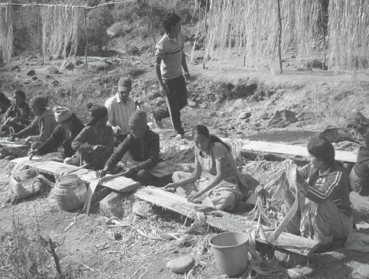
Extracting lokta or bark from the Daphne bholua shrub for papermaking (Photo by R.C. Sedai)
| The centuries-old technique of making paper in Nepal has been revived by outsider interest in handmade paper. In addition to the manufacturing along the Kali Gandaki, you will find it made along tributaries of the Arun and parts in between. The Daphne bholua shrub grows at elevations of 7000 to 11,000 feet (2100 to 3300 m), and the barks used for making paper are called lokta or baruwa locally. The outer barks are stripped off, cleaned, then soaked in water and dried and carried down to the processing area. The alkali leachate of wood ashes is used for digesting the barks by boiling the mixture in copper vessels, cutting them, and continuing the process until they are soft and breakable. The bark material is then pounded into a pulpy mass and mixed into a dense emulsion with water. The casting of the pulp into paper is done by a stream or pond by mixing the concentrate in a tank of water, and swirling just the right amount on a mesh frame. The slurry on the frames is left to dry in the sun, when the paper is removed. |
You can find cooked food and lodging along the entire route in season (ask at Chomrong before venturing forth at other times). During winter months, snowfall may make the trip difficult or impossible, and avalanche hazard can increase the risk.
This is the homeland of the Gurung people, an ethnic group renowned for bravery in the Gurkha regiments. They speak their own unwritten language, a member of the Sino-Tibetan family, and names of villages don’t transliterate accurately into Nepali. Hence the variations in spelling that you will see on signboards here. Is it Ghandrung or Ghandruk? Landrung or Landruk? Chomro or Chomrong? Kyumunu, Kimrong, Kymnu, Kyumnu, or Kimnu? We try to use the ACAP spellings.
For those traveling from Pokhara, one access route to the sanctuary leaves the road at Lumle to pass through Chandrakot. This is not a popular approach, as more people prefer beginning from Phedi or Naya Pul. If coming from the Kali Gandaki/Thak Khola, you could leave the standard trail at GhoRepani or Chitre.
Accommodations are available in almost all villages en route with opportunities to stay in traditional bhaTTi lower down.
From Pokhara (2713 feet, 827 m) you can either walk, or board a bus or taxi to get to the Baglung bus station (Nala Mukh or Besi Parak different from the Bas Parak, near Mahendra Pul), in the northern section of the city. Buses leave regularly. The first place trekkers leave the road is Phedi to either travel into the sanctuary via Landruk or to travel on the east side of the Modi Khola until reaching Himalpani.
Another place to leave the road is near Lumle, the site of a British agricultural development project where former Gurkha soldiers and others are trained in farming. It has one of the highest rainfalls in Nepal. Walk from Lumle (5300 feet, 1615 m) to Chandrakot (5250 feet, 1600 m) at the west end of the ridge in 30 minutes. The views from Chandrakot are unforgettable. You will cross the Modi Khola, which flows south from between the peaks Annapurna South and Machhapuchhre, which stand before you. The Annapurna Sanctuary lies upriver inside the gate formed by Machhapuchhre and Hiunchuli, the peak east of Annapurna South. The trail descends to the Modi Khola, follows its east (left) bank southward a short distance to a suspension bridge, and crosses to the prosperous town of Birethanti (3600 feet, 1097 m) 1¼ hours from Chandrakot.
Trekkers usually arrive in Birethanti by getting off the bus at Naya Pul, a 30-minute hike south of Birethanti. Those who are camping must be self-sufficient in fuel; there is a kerosene depot in Naya Pul. From Naya Pul, cross the Lumle Khola (3314 feet, 1010 m) from the bus drop-off point and walk to the suspension bridge (3428 feet, 1045 m) just east of Birethanti. There is an ACAP check post where you register. From here, the trail heads up the Modi Khola on its west (true right) bank toward the Annapurna Sanctuary. (The trail to the GhoRepani and on to the Kali Gandaki/Thak Khola heads west up the Bhurungdi Khola.)
Head east past the school, keeping close to the river, and passing fields and forests, to Chimrong (3707 feet, 1130 m) in 35 minutes. Keep alongside the river to Syauli Bazaar and then ascend to the village of Kliu (4593 feet, 1400 m) with lodges in 40 minutes. From here, the trail divides, providing two options.
The more direct route to Chomrong and the sanctuary, bypassing Ghandruk, is to proceed right and keep along the valley to reach Kyumi with a pair of lodges in 40–50 minutes. Kyumi (4380 feet, 1335 m) lies at a junction near the river between Ghandruk, 1970 feet (600 m) above to the west, and Landruk, across the river on a steel bridge and 820 feet (250 m) above. From Kyumi, continue following upriver to Himal Kyu (also, Naya Pul or New Bridge) with more lodges in 1½ hours, passing through Jhinu Danda (with a developed hot springs 15 minutes below the lodge area) and up to Daaulu (also Taulung; signs here might refer to this area as part of Chomrong) and Chomrong in 2¼–2½ hours from Himal Kyu.
Most people opt to ascend to Ghandruk from Kliu. Stay to the left and ascend along stone steps to Kimche (5381 feet, 1640 m), which has lodging, and on to teashops of Chane (5600 feet, 1707 m) at the entrance to Gurung country in 30–40 minutes from Kliu.
PEOPLES OF CENTRAL NEPAL: GURUNG |
| The Gurung are most prominent on high ridges and upper valleys below the Annapurna and Himal Chuli massifs north and east of Pokhara, eastward beyond Gorkha. They are an enterprising upland farming and herding people; their sheep herds are often seen along the Manang trail on the Marsyangdi river route. They are subdivided into many clans, but except for the Ghale (pronounced like “golly”), who prefer to use the clan name, most call themselves, simply, Gurung. They, like their Magar counterparts, occupy some of the most inaccessible villages, high on the mountainsides above the trekking routes. Young Gurung men are often encountered as porters; older Gurung of distinction may have served in the Gurkha regiments, and many have interesting tales. If you happen to stop at a Gurung village for the night, you might see their colorful dances, or other ritual or festival activities, some of which display very ancient characteristics. Especially interesting are Gurung funerary rituals (called arghun), which are described later. |
Machhapuchhre (Fishtail Peak) lit by the setting sun with accompanying moonrise (Photo by R.C. Sedai)
From Chane, a trail forks left to TirkheDUgaa in the headwaters of the Bhurungdi Khola, on the way to GhoRepani.
Stay right and ascend and cross a tributary a few minutes later, and continue uphill on a stone-laid path. Those coming from Landruk will join this trail near a chautaaraa and just beyond is a large, cement entranceway. Reach Ghandruk (6600 feet, 2012 m) in 40 minutes from Chane. Ghandruk is a large, affluent Gurung village. Much of the wealth comes from handsome pensions provided to Gurungs who have served in the British Army. This income was one of several factors that changed their primary livelihood from herding and hunting to sedentary farming. Tourism has further increased their wealth.
At the top end of Ghandruk, the trail leads to Banthanti and GhoRepani, at least a day’s walk. It takes 15–20 minutes to pass through Ghandruk, and the mountain views are spectacular. Do pay a visit to the ACAP complex on a spur near the lower end of town to see the energy conservation technology they espouse and more. There are two locally run Gurung museums as well as a medical post. Sometimes, Gurung dancing and singing can be staged for trekkers willing to pay for the show. A Local Youth Eco-Trekking Centre has been set up where local guides might be hired and tours arranged.
Leave the town to the northwest, and in 10 minutes cross a tributary. (The trail branching left here heads to TaaDapaani and on to GhoRepani.) Stay with the right branch and ascend through fields and oak forest in a side draw to reach Komrong Danda (also Kimrong Danda), a prominent notch (7400 feet, 2255 m) with lodges and magnificent mountain views, 50 minutes beyond Ghandruk. Descend steeply into the valley of the Kimrong Khola (also called Kyumnu and Kimnu) on a trail much improved over the one where Stephen got lost in 1969, to reach the river in 45 minutes (5940 feet, 1810 m). Cross here and head up to the few simple lodges of Kimrong Khola just beyond (where another trail ties in from TaaDapaani). Now climb steeply up the hillside and come to a junction near a hotel. The left branch heads to TaaDapaani. Stay with the right branch and enter the Modi Khola valley at Daaulu (also Taulung; signs here might refer to this area as part of Chomrong), 70 minutes from the Kimrong Khola crossing.
At this junction of the two valleys (7160 feet, 2182 m), there are signs pointing out the routes. On the return you can take the right fork here and descend the spur below, and then either cross the river beyond, and reach Landruk or stay on the west side of the river to Syauli Bazaar on a direct route to Birethanti. But to head to Chomrong, enter the tributary valley draining the south side of Annapurna South (left) and Hiunchuli (right), the major peaks before you. On the way is ACAP with a Safe Drinking Water Station as you reach Chomrong, a prosperous Gurung village (7054 feet, 2150 m), in 15 minutes from Daaulu. Pass the school 400 feet (122 m) above the center of town. There are many large hotels for trekkers here and shops, some of which rent out warm clothing and equipment. Chomrong had one of the first hyrodropower projects in the ACAP region, built in 1982, and the area now boasts a newer 30-kw plant.
From Chomrong, descend northward to cross the main tributary, the Chomrong Khola, on a suspension bridge (6200 feet, 1890 m) 20–25 minutes beyond. Climb through terraces and the few houses and tea shops of Kilche (6700 feet, 2042 m) and Banuwa with lodges and enter the main Modi Khola valley, which you will follow for the next 2 days. The trail was previously used only by shepherds, who drove their flocks of sheep and goats up during the monsoon to browse in the forests and the shrubbery above tree line.
Continue uphill to Sinuwa (7625 feet, 2324 m) in 1–1¼ hours from the suspension bridge. This last permanent settlement with lodges resulted from the trekker traffic. ACAP strictly regulates the area beyond Sinuwa with rules regarding fuel use as well as lodge location and size. Contour along a reasonable trail in a rhododendron-and-oak forest, reaching growths of bamboo as you go farther up the valley. Pass an abandoned shack that was a former ACAP post at a place currently without facilities known as Kuldhighar (8200 feet, 2499 m) in 60–70 minutes as you go through increasingly dense forest. The trail drops slightly from here and then appears transformed into the stone staircases similar to those of the Gurung villages to the south, but with the addition of drainage ditches.
The main mountain visible at the head of the valley is Annapurna III; Machhapuchhre, the “fish-tail” mountain whose name has been obvious for some time now, is off to the right. Enter a dense bamboo rain forest. The area around Pokhara and south of the main Himalaya receives considerably more rainfall than almost any place in Nepal. South of Pokhara, the Mahabharat Lekh, the range of hills above the Tarai, is lower than in other parts and does not obstruct the northerly flow of moisture. The trail is usually wet, and do not be surprised if leeches are lurking in this jungle except during the cold season. (For more about leeches, including tips for prevention and first aid, see Chapter 5 and the sidebar on Leeches in Chapter 6.)
| Bamboos are prolific, especially in the high-rainfall areas around Pokhara and the eastern hills. Bamboo (a type of woody grass) can be found at altitudes up to 13,000 feet (4000 m) in the east. It is a multipurpose raw material with an incredible variety of uses. Some species are very hard and can withstand great compressive forces as pillars. Bamboos don’t last long, and thus need to be replaced regularly. The softer ones are flexible, and thin strips can be woven into baskets and trays. They provide good protection against erosion because of their dense surface roots. This rhizome root system can hold up terraces and road banks. Villagers cultivate many species and harvest them in controlled fashion by thinning older poles, preserving the clump to protect the soil. Because they grow so rapidly, new shoots are soon out of the reach of grazing animals. Species take long periods to flower, sometimes up to 150 years. Some can be a foot (30 cm) in diameter and used as pillars or storage containers but are too large for most purposes. Smaller culmed species are used as fodder, while shoots are eaten by people. There are well over twenty species found, usually with specific Nepali names. Broad categories include bAAs, the large-stature species, at moderate altitudes; nigaalo, the smaller species; and maalingo, at higher altitudes, which produce the best weaving materials. Human torpedoes may be met catapulting down steep trails headed for home as they clutch their bamboo charges under their arms. You will often see people in villages stripping bamboo and weaving articles of it. Bamboos are used as building materials for bridges, roofs, floors, ceilings, and walls. Sitting mats (gundri), winnowing trays (naanglo), twine, sieves, pipes, water carriers, containers, straws, and a large variety of baskets are other uses of this versatile grass. |
Reach a clearing and several lodges of Bamboo (7700 feet, 2347 m), in 30 minutes. Cross several substantial streams. The third has an overhanging rock upstream that could serve as a shelter in a pinch. Eventually, you reach Dovan (8366 feet, 2550 m), with three inns, in 40–50 minutes. The rhododendrons festooned with moss in the forest beyond are gigantic; sometimes orchids can be spotted. This region has over 100 varieties of orchids. There are hemlocks too, but, due to excessive rainfall, not as many as elsewhere at this elevation.
Onward from Dovan the trail is subject to avalanches, passing several channels on the way to Annapurna Base Camp. You may find the remains of some near the trail. After heavy snowfall above, which may be rain along the trail, the safest course may be to wait a few days for the slopes to clear. Because none of the avalanche slopes can be easily seen from the valley floor, it is difficult to be sure when it is safe to proceed. Be aware that trekkers have been buried by avalanches along here. If up in the sanctuary, wait a few days if food supplies allow. If you need to cross this portion, especially between Hinku and Machhapuchhare Base Camp, you could cross to the east bank of the Modi Khola.
As you wend your way through the forest and cross several streams, at a slight rise you will find a small shrine (Panchenin Baraha or Barahathan). Local custom prohibits meat and eggs north of here, so as not to arouse the ire of the mountain gods, resulting in sickness and even death in your party. Although the custom is widely broken nowadays, Nepalis might explain the misfortune that has befallen some trekking groups and mountaineering expeditions in the sanctuary by its breach. Notice the weeping wall across the valley coming down from Machhapuchhre, a gift from the god Baraha. Shortly beyond, the forest opens slightly and below you can see the rushing river torrent.
A typical guest house sign near the Annapurna Sanctuary (Photo by Mark Jackson and Susan Bergin/SAFA Himalaya Collection/Nepal)
Come to a pair of lodges at a clearing, called Himalaya (9425 feet, 2890 m), in just over 1–1¼ hours beyond Dovan. After another stretch of forest, the valley begins to open up. In 35–45 minutes reach Hinko (10,300 feet, 3139 m), a large overhanging rock.
Cross streams and proceed through the boulders of an avalanche trough and reach Deorali (10,600 feet, 3231 m) 30 minutes from Hinko, where there are several lodges. Notice the beautiful birches growing in this area. A route on the other side of the valley might be in use as a detour around the avalanche channel. It ties back in near the former lodges at the site named Bagar. Pass these former lodges, now abandoned, and cross streams. As you proceed along, you can admire before you the triangular snow-and-rock face of Gangapurna.
Suddenly, you cross through the imaginary mountain gates and are inside the sanctuary! A stream flows in from the west and a large grass-covered moraine is ahead of you, with more grassy slopes beyond. Reach a shelf with several inns, the so-called Machhapuchhre Base Camp (12,150 feet, 3703 m), in 1½–2 hours. Nearby is a meteorological data collection station. The west face of Machhapuchhre looms above you. There has not been a legally sanctioned expedition to sacred Machhapuchhre since 1957, and that one stopped short of the summit. Be cognizant of the rapid gain in altitude and possible symptoms of AMS. As Annapurna Base Camp is more than 1300 feet (400 m) higher, some people use Machhapuchhre Base Camp as the base for trips higher.
The trail heads along a stream between the lateral moraine to the right and the north slopes of Hiunchuli on the left and ascends to pass seasonal goTh along the way. In less than 1 hour, the halfway point to the Annapurna Base Camp is reached (12,925 feet, 3939 m). The views are exceptional from here but are even more monumental farther on, at the Annapurna Base Camp, where several lodges provide food and shelter during peak season. This flat area (13,550 feet, 4130 m) was first used by the British in their successful first ascent of the South Face of Annapurna in 1970. It is the coldest and windiest of all places to stay, but is well worth it in views if you are acclimatized and suitably equipped. Wandering around here, it would be difficult to not feel at peace with nature. Venture beyond to the crest of the moraine to gaze upon the awesome mountain walls. From left to right they are Hiunchuli, Annapurna South, Fang, Annapurna, Annapurna III, and Machhapuchhre. Tent Peak and Fluted Peak, rising above the hills to the north, complete the unforgettable panorama. Ghoral, a type of goat-antelope, might be seen in this area as well. Consider emerging from the warmth of the lodge to view the majestic scene under moonlight as well.
This route keeps high, traversing the ridge system to reach Ghandruk. Do not travel this route alone, as bandits sometimes work the forest. A viewpoint 40 minutes along the way from GhoRepani offers a grand panorama that rivals Poon Hill and could be a time- and energy-saving alternate to the early-morning jaunt in the opposite direction.
The trail begins from both upper or lower GhoRepani. Follow the signpost from the lower section to climb to the ridge above, or from the upper part, properly known as GhoRepani Deorali (9450 feet, 2880 m), head east through the forest, keeping close to the ridge. Reach a clearing (10,360 feet, 3158 m), in 40 minutes, with an immense panoramic view of Machhapuchhre to beyond Gurja Himal. Climb a little more before descending to Deorali Pass (10,140 feet, 3090 m) in another 30 minutes. (The trail mentioned earlier from Chitre joins here.) There are inns here and a viewpoint 30 minutes above. Head south to descend a steep gully that is treacherous when wet or icy. Pass another lodge, and continue in a moss-festooned rhododendron forest until you reach Banthanti (“place in the forest” with several inns) (8740 feet, 2664 m) beneath a steep cliff in 45 minutes–1 hour. Himalayan black bear have been recorded here, but your chances of spotting one are slight, for it is nocturnal.
Cross the stream and begin climbing, pass a lodge and another at a viewpoint before heading downhill to cross a stream. From here it is uphill along a stone staircase through forest to TaaDapaani (meaning “far water,” 8800 feet, 2682 m), beautifully situated in a notch, in 45 minutes–1 hour from Banthanti. All of the facilities at these places where there is no farmland have been set up for trekkers. There was no sign of habitation here 30 years ago. Just below the pass, to the southeast, there is a trail fork, with the right branch going to Ghandruk, the left to Chomrong, the gateway to the Annapurna Sanctuary trek. Both options will be mentioned.
To go to Ghandruk, take the right fork to head downhill through rhododendron to BhAIsi Kharka (“buffalo pasture,” again with lodges, 8260 feet, 2518 m) in 35 minutes. From here the trail diverges, offering two routes to Ghandruk. Take the branch to the right and then continue to descend. The path crosses a tributary along the way and reaches the upper flank of Ghandruk in another 1½ hours.
If taking the left fork at TaaDapaani to go to Chomrong, there are two choices, and both lead to the route to Chomrong. The first is considered less strenuous and descends steeply to the north, passing lodges along the way to Chiule and more lodges as you reach Siprong (6480 feet, 1975 m). Continue downhill to cross the Kimrong Khola (6266 feet, 1910 m) before ascending to the village Gurjung (6644 feet, 2025 m) with lodges in 1¾–2 hours from TaaDapaani. Continue ascending to reach a trail junction in 30–40 minutes. Here the trail meets the trail from Ghandruk (as well as the other, more strenous alternate route from TaaDapaani which ties below with the trail from Ghandruk).
To take the alternate route from TaaDapaani to the junction with the trail from Ghandruk, begin by descending less steeply to the northeast. Reach MelAAje (7260 feet, 2213 m) village in 50 minutes. Descend steeply through terraced fields to the Kimrong (Kyumnu) Khola. Cross a suspension bridge to meet the trail from Ghandruk near the lodges of Kimrong Khola in 45 minutes from MelAAje.
This route avoids some backtracking and could be followed in reverse as a direct route to the Annapurna Sanctuary.
From Chomrong, return to Daaulu (also Taulung), (7160 feet, 2182 m), above the spur of mostly terraced land that appears to jut out into the Modi Khola valley. Take the left fork that descends steeply through terraced fields of millet. Reach the lodges of Jhinu (also Chinu) Danda (5758 feet, 1755 m), 40–45 minutes from the junction. This is a settlement of Jaishi Brahmans. There is a hot spring near the river about 15 minutes away, and a sign points the direction to the concrete pools.
Beyond, the main trail drops on the south side of the spur, to a bridge (5180 feet, 1579 m) at the Kimrong Khola some 15–20 minutes from Jhinu. Cross and make a brief, steep climb to return to the Modi Khola valley and drop down through stands of bamboo to the lodges at Himal Kyu/New Bridge (also known as Naya Pul), (4642 feet, 1415 m), some 25–30 minutes from the previous bridge. Himal Kyu has a Gurung meaning of “water from the snows.”
Just down from Himal Kyu/New Bridge, cross the Modi Khola to the east (true left) bank to another lodge at Himalpani, and then climb and contour through thick forest before reaching cutivated terraces. About halfway to Landruk you cross a suspension bridge over a tributary (5175 feet, 1577 m) near a waterfall. About 10 minutes beyond, do not take the stone staircase that descends to a hydroelectric plant. Cross another stream on a suspension bridge and within 5 minutes reach the main trail from Landruk to Ghandruk. A brief climb brings you to Landruk (5250 feet, 1600 m), a large Gurung settlement set on a hillside with many accomodations, 1½ hours from Himal Kyu/New Bridge.
Take the upper trail that heads out of the valley, to climb into the Pokhara drainage beyond as you contour south through tributary valleys. Ascend to Tolka (5660 feet, 1725 m), with many lodges, in 45 minutes. Pass through more lodging at Bheri Kharka and climb through the woodland out of the valley and a clearing with lodges at Bhichok Deorali (6923 feet, 2110 m) in 1¼–1½ hours. Continue in the same direction you have been walking and cross to the opposite (east) side of the ridge to contour above the Indi Khola valley, staying to the left at branches. Descend slightly to the lodges and tea shops and ACAP check post at Potana (6460 feet, 1969 m) in 30 minutes.
To head directly from Potana to the road at KAre, bypassing Dhampus, fork right on the way out to reach lodging at ThulA Kharka in 15–20 minutes. Descend and eventually pass through the village of GolDAdA before reaching KAre and the road in 1–1¼ hours from Potana.
Most people will opt to return to the road via Dhampus. To do this, do not take the right fork from Potana but stay to the left at junctions and continue to descend through rhododendron to reach Dhampus (5560 feet, 1695 m) in 1 hour from Potana. The main village is spread out farther along the north side of this ridge. The views of the snowclad giants from here are worth the wait if the weather has been bad. The road now reaches here and it might be possible to catch transport to avoid a steep descent to Phedi. Otherwise, descend along stone stairs. There are chautaaraa along the way as you descend through sala and chilaune trees.
As you drop down to the river valley floor, you’ll be impressed with this uncut forest so close to Pokhara. The people of Dhampus have traditionally protected this forest, and governmental programs belatedly realized that this social forestry should be encouraged. The path will cross the road several times as you continue steeply downhill. Reach Phedi (3750 feet, 1143 m) and the road to Pokhara in less than 1 hour.
The Manang area offers many of the same attractions of a trek to Jomosom via the Kali Gandaki/Thak Khola. The Manangba, the people of Manang, are a most worldly ethnic group, and some of the men may have traveled farther on the globe than you. The mountain scenery is perhaps more breathtaking than on the other side, if only because the peaks in the open Manang valley are closer. It takes a week to reach the town of Manang if you walk the entire way from Khudi or Besisahar (add 4 days if you walk from Thumsikot via The Gurung Heritage Trail, Chapter 9). There are no Thakali here running the kind of hotels and lodges for tourists that you find on the trail to Jomosom, but the local people have set up comparable inns and hotels that cater to Western tastes. A motor road is well on its way to connect Besisahar with Manang; however, much of the classic trekking avoids the road, and there are alternative routes to escape sections of the road as well.
Enjoy it all. Cross Thorung La and circle the Annapurna massif. It is a walk of nearly 135 miles (215 km), but the rewards certainly compensate for the effort. The circuit takes at least two-and-a-half weeks, perhaps a week more than just walking to Manang and then retracing your steps, but this includes time for some diversions. There are now seasonal inns set up on both sides of the pass, so it is possible to cross without being self-sufficient, though storms that catch you up high may make it difficult to reach lodging. A number of trekkers have died because they pushed on in deteriorating conditions when not adequately prepared with food, clothing, and shelter. Bad weather can threaten the party at any time, and it is prudent to wait it out or turn back rather than risk lives. Serious frostbite is not uncommon among those who are inadequately prepared. Crossings can be difficult or impossible if there is deep, soft snow on the pass. Such conditions can be expected from January to March, and often longer. The check posts on either side of the pass will advise you when conditions prevent safer crossings; however, this is not a substitute for good mountain sense.
As a variation in returning from Manang (or as an alternate approach to Khudi), you might consider taking a trekking route from Khudi toward Pokhara, avoiding Besisahar and Dumre while experiencing the scenes and culture of mid-hill Gurung villages, which cannot be had on the more commericialized circuit. The Thumsikot to Khudi route is described under The Gurung Heritage Trail in Chapter 9 (follow the route description in reverse if you choose to walk out this way). This route takes 3–4 days, and there are traditional accommodations, nothing like the usual trekker lodges. Most of the villages passed are inhabited by Gurung, who farm the high hills and raise sheep. Trekkers wishing to meet few other foreigners should consider this route.
The route is described from Besisahar, reached from the town of Dumre on the Kathmandu–Pokhara highway. The basic route description is very simple. The entire trek is spent going up the Marsyangdi Khola to its headwaters and then crossing a pass to reach the Kali Gandaki drainage. The lower portions of the valley are broad, and then the modern trail passes through the bottom of the gorge where the river cuts through the main Himalayan system, until it finally opens into a broader alpine glacial valley. Like the next major valley to the west, the Kali Gandaki, the Marsyangdi Khola was once a major salt-for-rice trade route. We have occasionally borrowed shamelessly from Liesl Messerschmidt’s booklet Kings, Myths and Apple Pie, on the local lore.
Dumre (1500 feet, 457 m) is reached in some 5 hours by bus from Kathmandu, or 2½ hours from Pokhara (depending on road conditions). From Pokhara, board the bus at the tourist bus station, Lakeside, or at the main bus staging area near the Prithvi/Lakan Chowk intersection, on the road that heads from Pokhara to Kathmandu. The bus terminals are often called bas parak (“bus park”). Minivans (“micro”) can be found 325 feet (100 m) north of Prithvi Chowk at the Micro Bus Stand.
Nepal’s dramatic landscape flourishes during the rainy season. (Photo by Gail Robson)
From Kathmandu, there are direct buses to Dumre or Besisahar from Baleju Bus Park in Kathmandu, and tickets can be purchased a day in advance. Minivans are available near Baleju, along the Ring Road from the bus park. During tourist season, tourist buses line up in the early morning along Kantipath just down from Thamel’s Tridevi Marg for transport to Pokhara and elsewhere. Additionally, you can find bus and minivans at Kalanki Chowk, the main intersection on the way out of Kathmandu before heading to the Thangkot escarpment. Be advised that those susceptible to motion sickness should choose to take a bus rather than a minivan.
The bus journey from Kathmandu follows the Prithvi Rajmarg, the highway between Kathmandu and Pokhara. This highway is the main artery out of Kathmandu for vehicles traveling to eastern and western Nepal as well as south to India. Just after leaving the Kathmandu valley, the road descends through the steep, twisting Thangkot escarpment. It is usually slow going up to Mugling, halfway to Pokhara, and the point of confluence of the Marsyangdi and Trishuli rivers, which become the Narayani River. Most vehicles turn south here to follow the Narayani 22 miles (36 km) to the highway that runs the length of Nepal, the Mahendra Rajmarg. Roads are planned for a direct route from Kathmandu to the Tarai to a possible new international airport in Bara District as well as to eastern Nepal. However, until completed, this current route is likely to remain clogged with buses and trucks.
Dumre, farther west along the Prithvi Rajmarg, is one of the many towns that have sprung up to serve the needs of travelers, traders, and villagers. It is a principal staging area for people arriving and departing for the hinterland of the Marsyangdi Khola. Keep a close eye to your belongings, as theft has been a problem in Dumre.
If you did not arrange transport all the way to Besisahar from Pokhara or Kathmandu, you can do so in Dumre. The feeder road is paved to Besisahar, reached in less than 2 hours from Dumre by bus, with occasional mountain views along the way.
Besisahar (2579 feet, 786 m) is a major town situated on a shelf of land above the Marsyangdi Khola, and is the Lamjung District headquarters and the site of a police check post. The town also has a district hospital, a prison, a high school, government offices, shops, a cinema, lodges, and electricity. It is a real “boomtown” in every sense. Above Besisahar on the ridge to the west is Lamjung Durbar, which was the summer palace of the sixteenth-century Ghale Gurung Rajas, who wintered down below. Climb up there for a view and a sense of the history of this region.
There are several choices from Besisahar onward to the circuit. The traditional route follows the road to Khudi. However, there are other options than following the road the entire way. We recommend taking the road as far as Belauti Bisauna and crossing the Marysyangdi to Lete, then continuing on to Bhulbule. The section from Lete to Bhulbule is described below, as is the way from Besisahar to Belauti Bisanna.
Another route that entirely avoids the road and travels to Bhulbule from Besisahar follows the opposite, true left bank of the Marsyangdi, bypassing Khudi. For this route, from the main bazaar in Besisahar follow the road down toward the hospital. Just before the hospital, at the main post office, head north on the road that branches left, paralleling the main bazaar road. After 15 minutes, take a trail that branches right from the road just before a large boarding school. Descend to the Marsyangdi Khola, crossing over a suspension bridge (2228 feet, 679 m) in under 15 minutes. Pass the tea houses of the small hamlet of Botephanth, ascend steeply, then descend to a bridge over the Bacchoukhola in 45 minutes. Cross the bridge rather than continuing up to the village of Khasur Besi, then contour to Lete, a walk of 45 minutes or 1½ hours from crossing the Marsyangdi. (A less obvious but shorter route from Botephanth forks to the left after climbing for approximately 25 minutes, then descends steeply to cross the Bacchoukhola on a makeshift bridge in under 10 minutes. From here, climb to a crest and then descend steeply to the Marsyangdi and follow the river to reach Lete in another 45 minutes.) The route from Lete to Bhulbule is described below.
Otherwise, to proceed from Besisahar on the west (true right) bank of the Marsyangdi, continue north through town to the end of the wide roadbed. The peak up the valley is Gyahi Kang. Just where the tarmac ends and the road (now dirt) descends, fork to the right by a chautaara across from a forestry office. Descend from the shelf and cross the tributary PoDjo Khola 10 minutes later. Follow the road from here. (For a short detour, reach a stone staircase in 5 minutes and climb steeply to the Magar village of Tanaute [2560 feet, 780 m].) Pass below Tanaute in 10 minutes. Continue along the road above the Marsyangdi Khola and reach Belauti Bisauna in 35 minutes.
From Belauti Bisauna, take the trail to the right away from the road to cross the Marysyangdi on a suspension bridge across to Lete in 1 hour from Besisahar.
From Lete, contour through fields and pass through Badagau, and ascend to the settlement of Batisemul/Mul Bazaar (2795 feet, 852 m), with tea shops, in 45 minutes. The trail forks from Batisemul, with the right branch leading on to Bhulbule (and the left to Khudi, crossing the Marsyangdi two times). Take the right branch and ascend through fields to the village of Simulchaur (3048 feet, 929 m) in 15 minutes. Shortly beyond Simalchaur the trail forks; stay right. Ascend and pass above the villages of Bandre and Ambote to contour around the mountain before descending to Bhulbule (2723 feet, 830 m) in less than 1¼ hours from Simalchaur. The trail ties in to the main Annapurna Circuit trail at Bhulbule. The route continues up the true left bank of the Marsyangdi. However, the ACAP check post is on the north or true right bank just beyond the suspension bridge across the Marsyangdi.

The “Model Tourism” village of Sirung (Photo by Tokozile Robbins)
WEAVING TRADITIONS: NETTLE |
Trekkers commonly come across weavers during their travels. A variety of fibers are used, including the giant Himalayan nettle (allo) in the east for making clothing, casting fish nets, and tumplines; raDi, a rough, felted woolen cloth used as a hooded blanket; or cotton used for the dhaka cloth to make traditional Nepali hats for men (Topi). |
With nettle as an example, the fiber is harvested after the monsoon before the plant flowers. Hands are protected by a bundle of cloth used to strip off thorns and leaves. The stems are cut, then the outer bark of a bundle of five is stripped off by incising the stem with the harvester’s teeth and pulling with the hands supporting the end by the feet. The outer barks are stored in twisted bundles and then boiled in a water/ash mixture. The subsequent washed fibers are rubbed with clay to separate them and then dried. The fibers are teased apart by stretching between the upper arm and toes and then spun using a hand spindle. The tip fibers are kept for fine yarn, the coarser middle ones for making mats. Trekkers can sometimes see people spinning while walking along the trail or attending to other chores. Borrow the “works” and see if you can do it! |
| Nettle is woven on backstrap looms in the winter when there is little fieldwork to be done. First the warp yarns have to be prepared for the loom and assembled, often stretching them around stakes in the ground. The loom’s warp beam is attached to the roof rafter or on a support beam and weaving begins. Items made from allo include sacks (bhangra) done in about five days, smaller bags (jholaa), tumplines (naamlo), jackets (phenga), often with cotton embroidery along the seams, and casting fish nets (jal) woven exclusively by men. |
If staying on the road to Khudi rather than detouring through Lete to Bhulbule, continue to the Khudi Khola, a main tributary stream that drains the east end of the Lamjung Himal. Reach tea shops and a lodge near the old suspension bridge in 35 minutes from Belauti Bisana. The mountains seen to the northeast are Ngadi Chuli and Baudha Himal. Either cross the old bridge (2600 feet, 792 m) to the older section of Khudi, or ascend and cross on a vehicle bridge (less than 10 minutes upstream) to the newer part of Khudi, on the east (left) bank of the Khudi Khola. There is a gomba, a Buddhist temple, on the ridge above the village. From Khudi north, the Marsyangdi valley turns, narrows, and changes character.
If traveling by way of Khudi, two trail options are available from Khudi onward. Both choices meet up in Shyange a few days up the Marysangdi Khola. The traditional route is to continue on to Bhulbule and follow the Marsyandi along its true left bank before crossing back at Shyange. The other infrequently chosen adventurous option is to stay high, traversing the hills to the northwest of the Marsyangdi before descending to Shyange.
The lesser-used passage from Khudi to Shyange travels via villages high above the river’s northwest (right) bank and will take a full day longer than the traditional route. There are currently only a few lodges with basic facilities, although more facilities are being developed. Home stay might be required, and the route is not always obvious—you might have to ask locals for directions.
Just above Khudi, to the left from the road ascend on concrete stairs to a gomba on a crest above the village (this high route bypasses the first ACAP check post at Bhulbhule). Pass to the left of the gomba. There are several paths that make a shortcut of the more circuitous, wider trail to the spread-out settlement of Taraphu (3018 feet, 920 m), which lies on a plateau 20 minutes from leaving the road. From the upper houses at the northeast end of Taraphu, follow the wide track for 15 minutes before taking a narrower trail that branches to the left to contour and ascend to the east of a ridge. In under 1 hour the trail forks; the left/upper trail crosses a tributary and ascends steeply to pass a chorten on the way into Dhangai (5194 feet, 1583 m), a Gurung village, 1½ hours from Taraphu. There are a few shops and plans to build lodging facilities. (If you take the right/lower path, you will cross the same tributary where there is a natural pool in the stream. This lower trail heads below the village of Dhangai, ascending steeply and then contouring up the Marsyangdi Khola valley before tying in later with the upper route that went through Dhangai.)
From the lower end of Dhangai village, the trail passes a chorten on the way out of town and contours to the northeast. (A lesser-used and more difficult trail to Sirung village heads from the upper end of Dhangai and ascends to cross the ridge to the northeast.) After 10 minutes, the trail divides. Take the right/lower path to head to Ghosing and on to Sirung. After 20 minutes from the fork the trail ties in with the lower trail to Ghosing that bypasses Dhangai. In another 2 hours the trail branches again. The right/lower fork bypasses Ghosing and heads directly to Sirung. Take the left/upper path which ascends to pass by a school and then reaches the Tamang village of Ghosing (5840 feet, 1780 m) in 30 minutes from the juncture or 3 hours from Dhangai. Ghosing has a simple lodge and a few shops. Another 10 minutes beyond Ghosing is the hamlet of Nanamro (5794 feet, 1766 m). From the northwest end of Nanamro, the trail descends and meets the trail to Sirung that bypasses Ghosing and Nanamro. Just beyond is a suspension bridge (5463 feet, 1665 m) over the Gade Khola. Cross the bridge and ascend sharply to the “Model Tourism” village of Sirung (6115 feet, 1864 m) in just over 1 hour from Ghosing. A small gomba lies above town. (To the left and below the gomba is the difficult, high trail link to Dhangai.) Another trail ascending to the right of the gomba leads to Dudh Pokhari, a high lake 2 days away requiring self-sufficiency in food, fuel, and shelter as there are no facilities.
The trail to Kalagiring heads from the northwest end of Sirung. Contour, keeping to the largest trail and reach Kalagiring (5961 feet, 1817 m) in 45 minutes. Continuing on, the trail heads out from the northwest end of the village and after 15 minutes reaches a junction. Take the right/lower path to head to Sildhunga (the upper path leads to a village named Garigaun). After another 30 minutes, come to a rest area at a major junction. The left path ascends steeply to Garigaun; the right descends to Ghoptegaun. Continue straight. Be aware that this area is especially leech-infested during the rainy season. The path then crosses an area prone to landslides and arrives at the large village of Sildhunga (5164 feet, 1574 m) in 2 hours from Kalagiring.
The trail heads out from the northeast of Sildhunga and descends to reach Atkhet (4741 feet, 1445 m), a Chhetri village, in 30 minutes. From here the trail branches. Head left/north, rather than descend, and then contour, passing below a small gomba, to the Gurung village of Chapdanda (4757 feet, 1450 m) in 30 minutes. Head west out of Chapdanda, contour, and descend to cross a suspension bridge over a dazzling gorge of the Sangu Khola in 20 minutes. Shortly beyond the gorge, just past a pipal tree, the trail divides again. Take the left branch to reach the upper houses of Mipra (4350 feet, 1326 m) a few minutes beyond and then descend to the lower section of Mipra. From the bottom of the village the trail diverges. Rather than descending directly toward the river, take the path to the left and contour through fields for a few minutes before descending steeply along stone laid steps to meet the road in 30 minutes. Follow the road to the left for five minutes to cross a vehicle bridge below a giant waterfall and reach Shyange (3609 feet, 1100 m) in a little over 2 hours from Sildhunga.
To reach Manang from Khudi via the usual route along the east side of the Marsyangdi Khola, follow the road along the river for 30 minutes to Bhulbule (2723 feet, 830 m), where there is an ACAP checkpoint. Cross to the south (left) bank on a long suspension bridge (2720 feet, 829 m). Bhulbule originally gets its name from the sound of a natural spring that bubbles up from cracks in the rocks nearby.
The route continues eastward out of Bhulbule along the south (left) bank of the Marsyangdi Khola. A vehicle road is being planned from Khudi to Ngadi on this side of the river but may not materialize for some time to come. Continue upstream from Bhulbule and pass the first beautiful, thin waterfall on your right. You discover the rest! Below it is a fine pool for bathing—much better than the main river, but keep in mind that this is a drinking water supply. Beyond, fork left, rather than climbing, except in the monsoon. Pass below rather than climbing above to the town of Taraanje.
In 1–1¼ hours from Bhulbule, reach Ngadi (3000 feet, 914 m), on the banks of a small tributary stream. Lodges and shops strung out along the trail refer to themselves as part of Ngadi as well. The village of Tainchowk, above Ngadi, is worth exploring. There is more of Ngadi beyond a suspension bridge (3060 feet, 933 m) over the Ngadi Khola. Cross it to the right bank of the Ngadi Khola, and take the left of the two trails, heading toward the Marsyangdi Khola.
LEECHES |
| The terrestrial leeches of Nepal are sanguivorous ecto-parasites living off the blood of their hosts. They thrive during the wet conditions of the monsoon season and find hosts by detecting mechanical stimuli such as vibrations, heat, and chemicals (carbon dioxide) given off by their prey. These jawed leeches (Gnatbobdellida) attach themselves by means of tiny teeth or sharp cutting edges; however, a bite usually goes unnoticed because they are capable of dispersing a concomitant anesthetic. Leeches also use an anticoagulant to keep the blood flowing and eventually will drop off the host once sated. This may take upwards of twenty minutes, in which time the leech can swell several times in size. A single feeding is enough to sustain a leech for several months. Some burrow into the ground to survive long dry periods. Leeches are hermaphroditic and deposit eggs in a cocoon after copulation. They can exhibit advanced care of their young not regularly seen in the phylum Annelida. Leeches are still used medically during recovery in some plastic/reconstructive surgery cases. For information on removing leeches as well as preventing and treating leech bites, see Chapter 5. |
Contour above the river to meet a road in 15 minutes. (This road was built for a hydroelectric plant and continues 10 km up the Ngadi Khola to the Gurung village of Naiche and beyond in an area famous for honey hunting.) Ascend on this road for 15–20 minutes to where the trail branches to the left/north from the road. Climb through Lampata to reach Bahundanda (literally, “Brahman hill”), on the right of a prominent brow at a saddle (4232 feet, 1290 m) 1 hour 20 minutes from the crossing of the Ngadi Khola. There is a police post here and good views to the north if the weather is clear. On the high hills all around are Gurung settlements, and this used to be the northernmost settlement of Brahmans in this river system. There is a hot springs (taato paani) at the edge of the Marsyangdi Khola, below the knob of Bahundanda hill. A trail to the hot springs branches down from Lampata or from the lower end of Bahundanda and heads to the village of Dingding and then over the ridge to its west and down very steeply to the river. The pools can be excessively hot.
To continue onward, descend into another tributary valley, pass Badalbisaunaa (meaning “resting place in case of clouds”) in 45 minutes. (Shortly before reaching Badalbisaunaa, the trail divides. Avoid the left/lower fork, which descends to the river.) In another 25 minutes cross a stream on a cantilever bridge and ascend up large stone stairs to Lili Bhir (3700 feet, 1127 m). The name Lili Bhir originates from the Gurung word for ladder, li, while bhir means “bluff.” Formerly, ladders were used to cross the next section with sheer dropoffs and it is along here that prominent Nepali journalist Kanak Mani Dixit slipped from the trail and waited several days to be rescued. Follow the main river valley and trail, beautifully carved out of the rock wall of the valley. Pass the houses and lodges of Khanigaon (3900 feet, 1140 m) in 30 minutes, and then Ghermu Phant (3789 feet, 1155 m), from which a large waterfall above the settlement of Shyange can be seen, along with a hydropower plant at its base. Arrive at the large suspension bridge over the Marsyangdi (3609 feet, 1100 m) in 30 more minutes and cross it to the west (right) bank to Shyange in 2 hours 10 minutes from Bahundanda.
Shyange was named after the sound of its nearby waterfall. The village used to be higher up during the heydays of the salt trade but was relocated as the valley floor became the main route through here.
You are now in the gorge of the Marsyangdi Khola. The trail follows the road and is different from the salt trade trail that snaked up and down the cliffs on bamboo ladders high up the walls. Then there were no settlements in the floor of the gorge, but as the trail was improved, the ups and downs diminished; traffic and facilities followed.
From Shyange the trail continues to Shirchaur and in 1 ¼ hours reaches the village of Jagat (4347 feet, 1325 m), meaning “toll station,” situated in a saddle in the forest. This used to be an old customs post for the salt trade with Tibet until 1950, and is inhabited now mostly by BhoTiya. Thakali not from here were given the power to collect taxes and were resented by the Gurung residents. There is a hot spring below by the river. The trail to the spring branches down steeply from the main trail 15 minutes from Jagat on the way to Chamje.
In 1 hour beyond Jagat, reach the small settlement of Chamje (4560 feet, 1390 m), which has a large overhanging rock that was a convenient sleeping spot for the porters carrying rice to trade for salt. There are many changes in the people, architecture, and vegetation as you head upstream. Structures are now built of stone, the vegetation is less tropical, and the culture more resembles that of Tibet.
Extensive forests of chir pine (Pinus roxburghii), locally known as khoTe sallo, occur throughout the subtropical zone in western Nepal (3300–6500 feet/1000–2000 m in the west, to 5500 feet/1700 m in the east). The forests are typically open, with no understory, because of frequent fires. Chir pine is a conifer with needles arranged in clusters of three. |
Broad-leaved, evergreen forests of Schima wallichii (chilaaune) and chestnut (Castanopsis indica), or dhalne katus, once covered much of subtropical central and eastern Nepal. Almost all of them have either been converted to agriculture or are much depleted, as they lie in regions of highest population density. Both species have oblong-elliptical, leathery leaves, alternately arranged on the twigs. The chestnut has silvery-gray fissured bark, while that of Schima is dark gray and rugged. The chestnut has a prickly fruit. |
Riverine forests with Toona spp. (compound leaves divided into eight to thirty pairs of leaflets) and Albizia spp., or Nepali alder (Alnus nipalensis), called utis, often grow along streams. The alder has elliptical leaves alternately arranged on the twigs, and the fruits resemble miniature fir cones. Alder also frequently colonizes abandoned cultivation and landslides. |
| There are small areas of evergreen forest in far eastern Nepal. The showy, large, red flowers of the silk cotton tree (Bombax malabaricum, syn. B. ceiba, known as simal, are a characteristic feature of the subtropical zone in spring. The flowers are clustered toward the ends of bare horizontal branches and are alive with mynahs, sunbirds, drongos, bulbuls, and other birds that feed on nectar. This tall, deciduous tree has branches that grow out from the trunk in regular whorls. |
Just beyond the village of Chamje, the Marsyangdi Khola gorge is very impressive. Descend for less than 10 minutes and cross to the east (left) bank of the river on a suspension bridge (4420 feet, 1347 m). The motor road stays on the right bank. The forests here are temperate broad-leaved with bamboo. Continue upstream to reach a few tea houses after 40 minutes and a lodge beyond.
Climb to emerge from the gorge with its torrent below. An ancient landslide from the mountain to the east filled the gorge here, creating a lake that has become silted in above (see sidebar below). Enter a broad, pleasant, flat valley with a somewhat quieter river; there is a nearby army post and a suspension bridge across the river that is not taken. During the monsoon, you might have to make a short steep ascent to the right before descending to the village. You have entered the Manang District, as indicated by a welcome archway. Continue ahead to the houses of Tal (named after the body of water beside this village) in the center of the flat valley (5460 feet, 1664 m) in 1¾–2 hours from Chamje. There are many facilities here including a police check post, a health post, an ACAP Safe Drinking Water Station, and a small gomba northeast of town and even a Christian church mid-town. Try to spend a night here, for there is nowhere else along the trek quite like it.
The area of Manang to the north is called Gyasumdo, meaning “meeting place of the three highways,” referring to the proximity of three rivers, Marsyangdi, Didh, and Nar Kholas, to the north of here. It is inhabited partly by BhoTiya, who are primarily agropastoralists. These people were the real trans-Himalayan traders of the region until 1959 or 1960, when the trade closed after the Chinese takeover of Tibet.
Prayer wheels (Photo by Gail Robson)
Make your way north up the valley. The trail forks in 30 minutes. Stay left to reach a suspension bridge (5610 feet, 1710 m) and cross to the right/west bank. If it is the monsoon season, you will have to ascend briefly and then descend to the bridge. Pass a few shops and a lodge as you proceed on a section that has been blasted out of the rock. In 1 hour come to a long suspension bridge (5960 feet, 1817 m) and cross to the left/east bank of the Marsyangdi and the settlement of Karte, also known as Khotro.
A trail heads south to Nache village and on to Dona Lake at about 15,420 feet (4700 m), but you must be self-sufficient in food and shelter to go on to this high lake.
LEGEND OF THE FORMATION OF TAL VILLAGE |
Tal, meaning “lake” in Nepali, refers to the feature created when a gigantic landslide, whose scar can be seen at the southeast end of the valley, blocked the outflow of the Marsyangdi. Eventually the lake became silted in and became this flat area. |
| Liesl Messerschmidt describes a Gurung legend about this lake. The mountains on either side of the valley are sacred deities. The east one is Akhe Kai Du, meaning “old grandfather rock,” which looks to local people like a torma, the Buddhist ritual tsampa offering. The western one is Pakre, which is the entire eastern end of Lamjung Himal. These two deities, angry with one another, started to fight and threw boulders across the gorge, until Pakre won. The fight caused the slide on Akhe’s side. Afterward, they made up and became blood relatives or mit (pronounced “meet”). In front of the falls, you may see a chorten built by the local lamas to appease the gods to not send more landslides. |
This alternate route to Dharapani provides an opportunity to get away from the main route to visit the serene village of Nache before descending to meet the main route near Dharapani. It is an arduous climb but worth the effort to visit a location unblemished by mass tourism. There are few facilities here, but home stay might be arranged if you would like to spend the night.
From Karte, head right after the bridge. Just out of the village, take a left fork and ascend steeply up a narrow gorge. Reach Nache (7441 feet, 2268 m) in 1 hour from Karte. The trail to Dona Tal heads east from here past the school below the village; however, self-sufficiency is required in food and shelter along with vigilance for the signs of AMS. The trail to Dharapani heads down to the west from the chorten passed on the way up from Karte and just south of Nache. In 40 minutes of steep, sometimes exposed downhill with sheer dropoffs, tie in to the lower, main trail from Karte to Dharapani. The bridge is a few minutes beyond.
The direct, faster route from Karte to Dharapani is to head left/north; this route is prone to landslides. In 25 minutes cross back to the west bank. Beyond is Dharapani (6180 feet, 1884 m). The lower portion is where traders used to graze their pack mules in the fields overnight. Continue to an ACAP and police check post in 10 minutes.
As you continue on from the check post in Dharapani, note the valley coming in from the northeast. It comes down from Larkya La and leads north of Manaslu to the Buri Gandaki. A trail from Dharapani leads to this pass and the Manaslu Conservation Area Project (MCAP). An MCAP entry permit is needed as well as a restricted area permit to enter the Manaslu Conservation Area near Bhimdang, and independent trekkers are currently not allowed to visit unless in a group of two or more that is led by an agency.
The general direction from Dharapani along the road is northwest, rather than north. The village of Thonje—in Gurung, “pine trees growing on a flat place”—lies to the right across the Marsyangdi at its confluence with the Dudh Khola. Such river junctions are considered to be sacred places in Nepal; there is a small shrine located there. Some Gurung along here practice shamanism with blood sacrifice, which is distinct from the Tantric Buddhism of the lama who migrated here from Kyirong to the north, which proscribes such practices. Such tolerance of different traditions is the norm in Nepal.
A pleasant 35-minute walk along the road brings you around the corner to the fractured town of Bagarchap (6955 feet, 2120 m), meaning “butcher’s place.” This once picturesque town with a waterworks flowing through it was divided by a landslide in 1995. There are views of the Annapurnas and part of Lamjung Himal, and better views can be found from the village of Galangchowk, 10 minutes up on the ridge top south of Bagarchap (see below).
BIRDS OF PREY OF THE TEMPERATE ZONE |
| The Himalayan griffon vulture (Gyps himalayensis, length 4 feet, 122 cm), like most vulture species, has long, broad wings and a short, broad tail. It sails majestically on motionless wings over mountains and valleys searching for food. From below, adults show white underparts and forewing and a dark trailing edge to the wing; immatures are dark brown. Occurs from subtropical to alpine zones. |
To visit Thonje and briefly avoid some of the motor road on the way to Bagarchap, the serene trail heads right/east out of the upper end of Dharapani. Cross to the right/east bank of the Marsyangdi on a suspension bridge (6289 feet, 1917 m). Just up from the bridge, the trail forks. The right fork heads to Bhimdang and on to the Manaslu Conservation Area Project area. Take the trail to the left/north and pass through Thonje in less than 10 minutes from Dharapani, and continue up the east side of the Marsyangdi for 20–25 minutes to another suspension bridge (6522 feet, 1988 m) back to the west side of the river. There is a difficult-to-reach, undeveloped hot springs below the west side of the bridge here. Ascend up to the road and follow it to Bagarchap in 20–25 minutes, less than 1 hour from Dharapani.
This scenic upper trail offers a detour that climbs high away from the road to pass through beautifully situated villages that receive little tourist attention. The trail branches to the left from the road some 10 minutes from Dharapani, and climbs to reach the cluster of houses of Odar (7201 feet, 2195 m) in 25 minutes. A further 10 minutes uphill brings you to a few more houses and then a gradual descent to the hamlet of Ghalangchowk (7218 feet, 2200m) in 10 more minutes. Bagarchap is a 10-minute descent from Ghalangchowk, a little more than 1 hour from Dharapani.
Landslides happen frequently beyond Bagarchap. From town, take the left fork and do not go down to a bridge crossing the Marsyangdi Khola which heads up to Tache village on the other side of the valley. Danakyu (7140 feet, 2190 m), a long village stretched along the trail, is 30 minutes beyond with an ACAP Safe Drinking Water Station. There are apple, plum and peach trees around here. Continue in temperate mixed broad-leaved forest. The route now ascends to Timang rather than along the old valley bottom route. A few minutes from Danakyu, cross a bridge over a tributary and fork left to ascend to Timang (8642 feet, 2634 m) in 1–1¼ hours. A high trail from Timang to Dudh Pokhari and on to the large Gurung settlement of Bhujung heads off to the southwest but crosses a high pass with no facilities and you must be self-sufficient in food and shelter for several days.
The trail to the northwest out of Timang gradually contours to several lodges (8900 feet, 2713 m) in 35 minutes.
Descend to cross a tributary on a suspension bridge (8660 feet, 2640 m) in under 15 minutes and then ascend to the village of Thanchowk (8822 feet, 2689 m) in less than 15 more minutes. From here, the trail proceeds west out of town. Just after leaving, avoid a fork that descends to a school. Contour above the river to Kotho (meaning “walnut” in Gurung), also known as Kyupar, 8300 feet, 2530 m) in less than 1 hour, 2 hours from Timang.
The prominent tributary valley to the north is the Nar Khola, which drains the region called Nar Phu, whose inhabitants are traditionally pastoralists. Do not take the right fork heading there, just beyond the police check post in the upper part of Kotho, unless you have permits to enter this restricted area, obtained from the Immigration Office in Pokhara or Kathmandu. Permits cost between $75 and $90 USD a week per person depending on the season. The splendid valley walls around Kotho are reminescent of Yosemite National Park in California.
Wooden cantilever bridge spanning the Marsyangdi River (Photo by Tokozile Robbins)
To continue to Manang, enter Chame (8580 feet, 2615 m) in 25 minutes. The name means “fields in the warm sunny corner under the cliffs,” an all too brief daily occurrence. Above town is a gomba as well as a Hindu temple, the result of being a government town. Chame is the district center for Manang with many transplanted lowlanders and practicing Hindus subsequently living here along with the resident Buddhists. Chame has a bank, a health center, a local jail, and many supply shops and a few Internet cafes as well as an ACAP Safe Drinking Water Station.
At the far end of town, first cross a tributary from the south and then the main Marsyangdi Khola, on a cantilever bridge (8620 feet, 2682 m), to the north (left) bank, there are more houses here as well as some hot springs. The hot springs are at the river’s edge about 650 feet (200 m) downstream from the bridge and beyond the last lodge.
Go up the valley past a mani wall of stones inscribed with prayers and through an elaborate chorten-topped gateway and more of Chame, to Taleku (8960 feet, 2791 m) in 30 minutes. Continue in the unrelentingly narrow valley of pine, hemlock, and cypress forest, crossing a landslide area, and in 1¼ hours reach Bhratang (9340 feet, 2895 m).
There used to be a Khampa village situated across the valley from here. These Tibetan refugee warriors settled here after the Chinese occupation of Tibet in 1959 and subsequently made raids to the north. They built several bridges; on Stephen’s first journey to this area, the bridge here was still in use and had remnants of a gate used to maintain control over travelers. The former village had a huge meeting hall for strategy sessions. The Khampa were all resettled in 1975, and the town was eventually demolished, with some structures rebuilt on the other side of the river to serve trekkers.
From Bhratang, head upstream on a trail carved out of the narrow canyon walls, through hemlock and pine forest. Cross again to the south (right) bank in 45 minutes on a suspension bridge (10,010 feet, 3050 m), and then climb into a serene pine, hemlock, and fir forest. After the days in the gorge, you can appreciate the beauty and silence of these next 45 minutes up to the facilities at Dhukur Pokhari Danda (10,470 feet, 3190 m), 1½ hours from Bhratang.
As you look east, behind you, the Great Wall of Pisang rises almost 5000 feet (1500 m) up from the valley floor. The names for the wall include Oble in Gurung, Yunga Drag Thang in Tibetan, and Paungda Danda in Nepali, all roughly equivalent to the “Mountain of Heaven.” This arc of slate portrays the intense folding of lakebed sediments that were upturned in the creation of the Himalaya. At the top are two stone formations, locally known as either a temple with a dog-hitching post next to it, or the house of the wise old grandfather with himself standing beside it. Legends regarding the wall involve the Manang salt trade and Gurung death rituals. For the Gurung, traveling to this wall was an important life milestone. As they passed it, they would ask the grandfather up above the price of salt farther along the salt trail, and dance and drum before continuing on. For the Gurung of Gyasumdo below, this dome is the entrance to the land of the dead. The spirits of the dead must be led by a shaman’s ritual, and the huge boulders at the top represent the temple of the dead. For details, see Mumford’s book listed in Appendix A. Relatives of the dead travel to the wall to pay their respects; they build chorten and make offerings and shout their ancestor’s names, which echo back to them.
As you proceed on from Dhukur Pokhari Danda, just beyond a mani wall the trail divides.
If you fork right, the trail goes directly to Upper Pisang by first crossing a wooden cantilever bridge over the Marsyangdi Khola to the north (left) bank (10,390 feet, 3167 m) in 10 minutes. Then in 10 more minutes the trail forks. Stay right, passing Tarkang GoTh, a seasonal pasture settlement, and pass through a gate in another 5 minutes. The trail passes above a large playing field (sometimes used for soccer matches) in 10 more minutes and then forks again in another 10 minutes. Stay left and reach Upper Pisang (10,600 feet, 3305 m), with lodges, in 45–50 minutes from the cantilever bridge crossing or under 1 hour from Dudh Pokhari Danda.
The left fork at the mani wall just out of Dhukur Pokhari Danda keeps to the valley floor and leads to Lower Pisang. Take this trail, and reach Lower Pisang (10,280 feet, 3207 m) in 45 minutes. This town is now mostly a collection of well-furnished lodges and has an ACAP Safe Drinking Water Station as well. Its name is derived from a word in the Managi dialect meaning “to work together at something.” Beyond the hill to the south of Lower Pisang are meditation huts at an overhanging rock. To visit on a day trip, the trail begins at the eastern end of town and climbs the ridge of the hill to the southeast.
For amazing views of Annapurna II, climb to Upper Pisang (10,600 feet, 3305 m) in 20 minutes, where there is a gomba. Like in many villages here, the roofs are flat. The roof of one house serves as the yard or open area of the house above it. In the middle of the village is a long, handsome wall of prayer wheels in an open space.
You are now in the wide, dry, arid region of Manang called Nyesyang, an abrupt change from the gorge. Because it is in the rain shadow of the Himalaya, which acts as a barrier to the wet monsoon clouds from the south, the area gets little rain in the summer. Snow falls here in the winter and remains on the ground much of the time. Unlike the people in the gorge to the south, the inhabitants here have been here for centuries. The men are traders and part-time farmers, and the women are full-time farmers. There is comparatively little animal husbandry. In the winter many leave for warmer places. You may meet many young men with considerable facility in English who have traveled far and wide in Asia. The people of Nyesyang were granted special trading privileges by the king in 1790. This included passports and import and export facilities. These privileges have been extended to all the people of the Manang District. Initially, they traded local items, mostly medicinal herbs, animal products, and semiprecious stones for manufactured goods, usually in India and Burma, but have also been using hard currency from the export of expensive items to import machines and other manufactured goods from South Asian countries. Seasonal migration means less practice of agriculture and animal husbandry, and you will not see many herds of yak, sheep, or goats at the higher elevations. These people are becoming dependent on foodstuff brought in from other areas.
From Lower Pisang there are two routes, which join up in the valley at Munchi, before the village of Braga (also known as Braka). The direct route keeps to the valley floor, staying mostly to the south. The other trail ascends on the north side of the valley to reach several villages on that side of the valley. The views of the mountains and the valley from this route are tremendous, and the villages are quite interesting, but it takes an additional 2½ hours to reach Braga with a steep climb. You will find fewer facilities here and as well fewer trekkers. We strongly advise you to take this higher route, and, if you can arrange it, to stay in local people’s homes.
The high, north-side route begins in either Lower or Upper Pisang. From Lower Pisang, cross the Marsyangdi Khola (10,510 feet, 3204 m) and immediately fork left to head upstream. Contour northwest in a pleasant pine and juniper forest. Pass by a small green lake, Mringcho Tal. (If you are coming from Upper Pisang, follow the long wall of prayer wheels to pass through a gateway. Contour and pass above this lake and meet the trail coming from Lower Pisang in 40 minutes.) Continue to contour, eventually reaching a long mani wall, then fork right to cross a tributary on a suspension bridge (10,890 feet, 3320 m) in 1 hour from Upper Pisang. Take the upper fork and begin a steady, steep climb for 1–1¼ hours to the hamlet of Ghyaru, meaning “goat pasture,” at 12,140 feet (3700 m). There are lodges here. Lore has it that when Tibetans came here to see if this was a good place to farm, they planted some wheat seed inside a yak horn. If the seeds germinated, as they did, it would be a good place to settle. The surrounding fields of wheat and buckwheat attest to that prophesy. Spectacular views of Annapurnas II and III and Gangapurna are the main attractions, along with the tunnel-like passageways of the village.
Contour out of the town to the northwest, cross a tributary, and take the higher fork to follow a mani wall, then another higher fork to reach a ridge crest (12,380 feet, 3772 m) some 100 feet (30 m) above ruins of an old fort in 45 minutes from Ghyaru. The fortress perched on this strategic site, Tiwol Danda (“red fort on the hill”), was the palace of the Manang Raja before the Gurkha conquest in the late eighteenth century. There are views of Gangapurna, Glacier Dome, and Tilicho Peak to the west. North of Tilicho Peak lies Tilicho Tal, the “great frozen lake,” named by Herzog, although it is out of view from here. If you cross Thorung La, you will eventually return to Pokhara by heading well north and then west of this peak.
Continue to contour, cross a tributary, and in less than 5 minutes from the crest take the left/lower fork and contour; another less-used trail joins from below. Reach a ridge crest with a view of Hongde air strip down in the valley. Cross another tributary to Ngawal (11,980 feet, 3650 m) 50 minutes from the ruins. A trail from the restricted Nar Phu valley reaches Ngawal from a high pass. If you ascend the hill to the northeast of the village, local folklore has it that a cave there, allegedly visited by Padmasambava, has underground channels that extend all the way to Mustang on the other side of the Annapurna range (a 3-day journey via the tunnel!).
Descend to the north to cross a tributary (11,950 feet, 3642 m), and then continue descending, avoiding a trail branching to the left 10 minutes beyond town just after passing a mani wall. Stay to the right and descend to the valley floor (11,270 feet, 3436 m), cross another tributary (11,320 feet, 3450 m), and pass above a school for Tibetan refugees. Reach the few houses of Munchi (11,425 feet, 3467 m) and lodge in 1¼ hours from Ngawal, or some 5 hours from Upper Pisang, and meet the main lower trail from Lower Pisang.
There is a large nunnery, Sher Gomba, above Munchi. It is of the Kagyupa sect and under the direction of Thrangu Rimpoche, and is associated with a nunnery at Swayambunath Temple in Kathmandu. Sher means east; this gomba lies to the east of the renowned Braga Gomba, which predates it.

“Om mani padme hum” mantra in Tibetan script, found carved in a rock along the High Route from Pisang to Braga (Photo by Tokozile Robbins)
For the lower route, start from Lower Pisang, crossing a tributary from the south just beyond. Avoiding a left fork, regain the Marsyangdi River by a row of mani walls, and continue on its south (true right) bank. Climb to a ridge crest, Ngoro Danda, in 45 minutes with a splendid view of the valley of Manang. Beyond, on the hill to the north is the “red fort on the hill,” the Manang Raja’s former fortress. Hongde (or Ongre, Omdhe, HumDe, or Hongre, 11,130 feet, 3392 m), a sprawling settlement with an airfield, is reached in another 45 minutes. The name degenerated from the Tibetan word meaning milk, referring to what was available when many yaks were pastured here.
Continue along on a wide track to cross another tributary, the Sopje Khola, from the south in 25 minutes. Some 25 minutes later, cross the Marsyangdi Khola (11,220 feet, 3420 m). Ascend along the north (left) bank for 10 minutes to Munchi (11,370 feet, 3467 m), 2½ hours from Lower Pisang, with a lodge and shops as well as a dilapidated series of houses where the high, north-side route from Upper Pisang joins the main valley route from Lower Pisang.
From Munchi, stay on the north (left) bank of the Marsyangdi for 25–30 minutes to Braga, also known as Braka (11,398 feet, 3474 m). There are several hotels below the village proper.
Braga (the name refers to the nearby white cliffs) is a large and interesting village, and the seat of the oldest monastery in the area. The gomba is perhaps 900 years old, and belongs to the Kagyupa sect of Tibetan Buddhism. Like most of the gomba in this region, it is not very active but is well worth a visit, for it contains some unique works of art and is spectacularly perched. The konyer (“custodian”) will show you around, sometimes with varying amounts of patience. The main temple holds 108 terra-cotta statues, each about 2 feet (60 cm) high, arranged in rows along three of the four walls. They represent the Kagyupa lineage and much more. There is another three-story temple above this main building. The temple is described in detail in David Snellgrove’s Himalayan Pilgrimage.
The village of Manang is 30 minutes beyond Braga. Along the way, 15 minutes above on a ridge to the north, lies the Bodzo gomba (11,750 feet, 3581 m). Directly to the north of it, across a tributary, is a Kagyupa gomba. Before going to either of these, try to determine whether the key bearer is around.
There is ample lodging in Manang (11,480 feet, 3560 m). You can restock your provisions, and there is an ACAP Safe Drinking Water Station here. Attend one of the Himalayan Rescue Association post’s lectures on altitude illness that are given daily in the high season. If you are planning to cross Thorung La and reach the Kali Gandaki to the west, it is important to spend a day or two acclimatizing here before proceeding. Do not go on to sleep higher if you have a headache. If you have flown to Manang, you should spend at least 3 or 4 days in this region before attempting to cross the pass. In addition, it is advisable to spend an additional night at Leder, before going on to Phedi.
Manang is spectacularly perched across from a glacial lake formed by water from Gangapurna and Annapurna III. To visit this lake, cross the Marsyangdi below town by an abandoned school and proceed to the right. Or, stay left and climb up the lateral moraine on its southeast side for good views of the Chulu peaks and Manang.
Another shorter excursion above the town of Manang leads to a hermitage (10,040 feet, 3060 m) built into an overhang in the cliff. The trail leads up from above the village to a large chorten in 20 minutes; an hour farther is the hermitage. “Donations” are required for the lama to perform a blessing.
Acclimatization days are best spent being active and climbing to high elevations for views but returning to lower altitudes to sleep. There are many suitable hikes near Braga and Manang on both sides of the valley; along with the two hikes just mentioned, several “rest day” activities are suggested in the side trips that follow. You may even see an archery contest or a horse race! These extra acclimatization days may be unnecessary for some or not long enough for others; they are guidelines on how to proceed with less risk.
For people traveling without food or tents, it is possible to cross the pass relying on local facilities, except during the winter, when crossing the pass is a mountaineering endeavor. However, it is best to bring some extra food from Manang or Braga. Ask here if Phedi is set up to provide services outside of the usual trekking season. This has recently become the case, even in the monsoon!
Side Trip to Ice Lake. Ice Lake (also known as Kicho Tal) lies over 3500 feet (1100 m) higher to the north of Braga (this lake can also be accessed by a trail from behind Bodzo Gomba, between Manang and Braga; however, the route is difficult to follow). The breathtaking hike offers sweeping panoramas along the way and is highly recommended. The trail emerges from above the village of Braga, leading east, and is signed along the way by ACAP. Fill your water bottles, as there are no water sources after leaving Braga until the lake itself, which is 2¾–3 hours away.
Ascend to a point above the village on the ridge between Braga and Munchi and just above Sher nunnery in 30 minutes. The trail then switches back to the northwest (a route from Munchi ties in here) and zigzags up the hill. In another 1 hour 20 minutes, reach a seasonal pasture area (14272 feet, 4350 m). About 45 minutes farther is a small pond, and 10 minutes beyond are the striking waters of Ice Lake (15,144 feet, 4616 m, N 28°40.723’ E084°03.603’) with a nearby goTh reached in 2¾–3 hours from Braga.
Side Trip to Milarepa Caves. These caves lie to the south of Braga across the Marsyangdi Khola and over 1800 feet (550 meters) up toward the base of Annapurna III. Jetsun Milarepa was an eleventh-century ascetic who lived an austere life in the high mountains between present-day Nepal and Tibet. He is revered by Tibetan Buddhists, especially of the Kagyupa lineage.
To reach the trailhead from Braga, head downstream (southeast) along the valley for a few minutes to cross the Marsyangdi on either a suspension bridge or nearby wooden cantilever bridge. There is more than one route up to the caves which lie 1 hour 40 minutes from Braga. The easiest is to head directly south from the cantilever bridge toward the hills (and not along the left fork to the southeast, a steeper ascent). Pass through fields before climbing steeply up the hill on a zigzagging trail. Within 45 minutes from Braga, reach a seasonal goTh settlement (12, 073 feet, 3680 m) with a possible camping area just below. Follow the trail to the southeast as it contours. In less than 10 minutes, cross a streambed. Water might be available from a small spring in the gully a minute below the trail here. A few more minutes beyond, the trail ties in with the steeper, more direct route. There is another goTh settlement just below the trail here. Another 10-minute ascent brings you to a stupa (12, 427 feet, 3788 m), 20–25 minutes from the goTh settlement, with a camping area just to the east and a nearby cement tap that might have water.
Another 30-minute climb up the glacial valley alongside the terminal moraine brings you to another large chorten, with a shrine and gomba (13,255 feet, 4040 m) just beyond. The caves are set in the cliff face to the west some 100 yards (meters) up and marked by prayer flags. The upper cave is inaccessible, whereas the lower involves a steep scramble from the gomba. A nearby, small chorten marks a place where footprints were allegedly imprinted in rock. The rock portion with these imprints is now housed below in the gomba. Devotees will tell you that a hunter’s bow hangs in the bluffs near the caves. Indeed, a bow-like shape can be made out. This is believed to be the retired weapon of a legendary hunter who gave up the chasing of animals after a fortuitous encounter with Milarepa.
The central figure in the gomba is, of course, Milarepa, flanked by his guru Marpha and chief disciple Gampopa (also known as Dokpa Kagyu). Nearby are stone huts for meditators, as well as a camping area with water available. Annapurna III glacier can be viewed by climbing south from the gomba 45 minutes to 1 hour along the lateral moraine to an otherworldly vantage point (14,249 feet, 4343 m).
Side Trip to Khangsar Village. An enjoyable hike is a trip up to Khangsar, the last town before Tilicho Tal. A motor road is being built from Manang to Khangsar, and there are several starting points from Manang as well as from Braga. If you are starting from Braga (2¼ hours to Khangsar), the route passes below Manang. Begin by following the route toward Manang and take the left fork just after passing a stupa in less than 15 minutes. Travel below Manang village in another 15 minutes, not crossing the Marsyangdi on the bridge below Manang. Do not cross another bridge a further 10 minutes up where the trail from Manang ties in to the direct trail from Braga.
Starting from Manang (1¾hours to Khangsar), one trail begins from a large stupa with prayer wheels that is mid-town and located just after the newer part of town. Fork left and descend to the bridge by the river. Do not cross the river here. The trail from Braga meets the trail from Manang at this point.
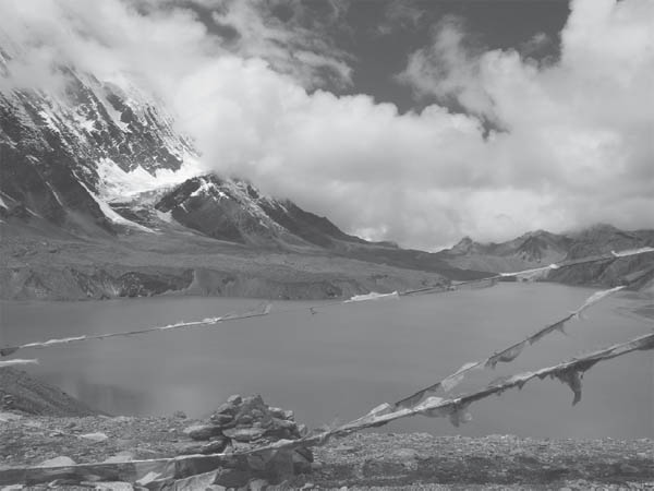
Prayer flags at the viewpoint overlooking Tilicho Lake (Photo by Tokozile Robbins)
Keep heading upstream to the west, traversing on the true left/north bank of the Marsyangdi to another bridge (11,729 feet, 3575 m) above the confluence with the Khangsar Khola in 30 minutes. Cross to south bank of what is now known as the Thorang Khola (also Jargeng) and ascend to a plateau, then continue to Khangsar (12,303 feet, 3750 m), 1 hour from crossing the river.
The trip to Tilicho Tal is an arduous, rewarding, several-day excursion through remote landscape away from the main circuit trail. On the return, rather than revisiting the main trail at Manang, a timesaving shortcut is introduced.
Tilicho Tal is a large, spectacularly set lake nestled at the foot of the north face of Tilicho Peak, part of the snowy wall that the 1950 French expedition team referred to as The Great Barrier. Hidden beyond this bulwark to the south was their objective, Annapurna (26,545 feet, 8091 m). The leader, Maurice Herzog, referred to Tilicho Tal as The Great Ice Lake, and it is often frozen in winter, and periods of thaw vary from year to year. Hindus believe that this sacred lake features in the Ramayana holy text.
The lake can be reached from Khangsar in 2 days; however, parties must be acclimatized. The trail beyond Siri Kharka can be very difficult if not treacherous under snowy conditions. Check with ACAP in Manang and in Khangsar about current conditions as well as to see whether the Tilicho Base Camp lodge halfway up the valley is in operation. From there you could make a long day trip to see the lake and return, without having to camp.
To proceed from Khangsar, join the trail from the stupa at the upper (northwest) end of the village and head west. A few minutes from Khangsar is a juncture. Keep to the right and in 5 more minutes pass through a gate and then fork right again. Reach Thare Gomba (12,959 feet, 3950 m), an ancient gomba of the Sakya sect, in 45 minutes from Khangsar. The trail ascends from behind the gomba and diverges 15 minutes beyond. (The right fork heads to Yak Kharka, on the Annapurna Circuit; this route can be followed to avoid backtracking to Manang on the return from the lake. Be sure to check beforehand that a seasonal bridge is in place over the Thorang/Jargeng Khola before taking this shortcut. This route, from Siri Kharka to Yak Kharka, will be described below.) Keep left, cross a tributary, and reach a lodge at Siri Kharka (13,320 feet, 4060 m) in 10 more minutes, 1 hour 10 minutes from Khangsar.
From Siri Kharka, reach a junction in the trail in 25 minutes and stay right rather than descend. Another 35 minutes beyond this junction the trail diverges again; stay left on the lower branch. This section from Siri Kharka to the lake was improved for a visit by a high-ranking lama of the Sakyka lineage in the spring of 2009. (The alternate high trail is not currently recommended, as it ascends over 2300 feet (700 m) and then descends precipitously through scree to Tilicho Base Camp.) Enter an area prone to landslides in 15 minutes, and for the next hour be wary of rocks tumbling from above as the trail passes through a steep incline of scree to a lodge at the so-called Tilicho Base Camp (13,583 feet, 4140 m) in 1¼–1½ hours from the trail junction (2¼ hours from Siri Kharka).
Continue west from Tilicho Base Camp. Bharal (blue sheep) abound in this area, and likely there are a few prowling snow leopards, which prey on the sheep but are rarely sighted. Reach the base of a series of switchbacks (15,607 feet, 4757 m) in 1½ hours. In another 45 minutes to 1 hour, reach a crest (16,375 feet, 4991 m) and follow the stone-lined trail past a few tarns on the left to an ACAP sign and prayer flag-laden lookout point (16,467 feet, 5019 m, N 28° 40.660’ E 083° 51.869’) in under 20 minutes (2½–2¾ hours from Tilicho Base Camp). You can pick a route down through the moraine to reach the lake nearly 100 meters below. Be aware that storms can blow up quickly and unexpectedly from the south in this region. On one trip, it went from not a cloud in the sky to pelting-down snow in an hour—and an accumulation of several feet by the morning!
On returning from Tilicho Tal, this route from Siri Kharka to Yak Kharka, which lies on the main circuit trail, avoids backtracking to Khangsar and Manang. Caution: Check with ACAP and locally to make sure a seasonal bridge is in place over the Thorang/Jargeng Khola before taking this shortcut.
Descend from Siri Kharka toward Thare Gomba and in 5 minutes from Siri Kharka reach a trail junction. Head to the left for Yak Kharka. Less than 15 minutes beyond is another trail junction. Again, stay left and in 20 minutes reach Old Khangsar (13,560 feet, 4133 m), which is uninhabitated except for occasional herders and during festival times. Follow the rock wall north out of Old Khangsar and then contour along it to the east. In under 20 minutes the trail separates from the walled enclosure and begins rising. There are many grazing trails in this area. Keep to the widest path and ascend to a ridge crest (13,652 feet, 4161 m) in 25 minutes with a steep drop-off overlooking the Marsyangdi Khola valley. You might even make out the circuit trail across the valley to the northeast.
From the crest, the trail leads north as it descends through birch into the Thorang/Jargeng Khola valley. Reach a seasonal bridge (12,648 feet, 3855 m) in 45 minutes just upriver from a feeder tributary, the Khenjang Khola, coming in on the other side of the valley. Cross to the east bank of the Thorang/Jargeng Khola and ascend along the feeder tributary’s north bank, to a plateau. Just beyond the trail ties in to the circuit trail where there is a long mani wall (13,058 feet, 3980 m), 40 minutes from the seasonal bridge. Reach the collection of lodges known as Yak Kharka (13,020 feet, 4040 m) in less than 1 hour (3¾ hours from Siri Kharka).
A week (perhaps a year!) in Manang or Braga would not exhaust the interesting options available in this area, especially useful for acclimatizing. However, if you have walked in from Besisahar and have spent a day or two in Braga or Manang without symptoms and are feeling healthy, then you are likely ready to continue onward to Thorung La. Keep in mind that this pass is higher than most of the world’s mountains (outside of central Asia) and the highest point that most people will likely ever reach in a lifetime. The pass is desolate and stunningly beautiful and will be a memorable experience. However, it is not for everybody. Be vigilant for signs of altitude sickness, and descend back to Manang or lower if necessary.
Additionally, do not attempt to cross Thorung La unless all of the party, including the porters, are equipped for cold and bad weather. If the weather is threatening, do not proceed. Lives of trekkers and porters have been needlessly lost on this pass because parties proceeded in bad weather. Many people have been crossing the pass wearing running shoes and other light footwear. If you do not carry proper boots, at least recognize that there is risk of frostbite should a storm occur. Trekkers have gotten serious frostbite on this pass. Losing fingers and toes is a big price to pay! If stuck with poor footwear, in bad conditions, and unwilling to turn back, wrap your feet in plastic socks as a vapor barrier. This may help, but there are no guarantees. There is safety in numbers, and it is best to travel in a group.
To proceed from Manang over Thorung La, cross a tributary below a falls northwest of Manang and climb up to Tengi (12,106 feet, 3690 m) in 30 minutes. This last permanent settlement below the pass has few tourist facilities. Climb gradually and avoid a right fork after 45 minutes to reach some goTh and hotels at Ghunsang (12,874 feet, 3924 m) in 1 hour. Another 30 minutes farther is a higher settlement of goTh and a hotel at Khenjang Khola (13,002 feet, 3963 m) with a tea shop over the bridge on the other side of the river. The trail has now turned northwest up the valley of the Jargeng Khola. If you are here early in the morning or late in the afternoon, look for herds of blue sheep, which often descend for water at those times. Reach the collection of lodges known as Yak Kharka (13,020 feet, 4040 m) in 1 hour, passing one lodge 10 minutes before as well and finding another lodge 15 minutes beyond the main lodge cluster.
In less than 20 minutes from the last Yak Kharka hotel, cross a tributary on a suspension bridge (13,806 feet, 4208 m). Within 5 minutes, reach the first lodges of Letar (13,862 feet, 4225 m). There is an ACAP Safe Drinking Water Station in Letar. It is possible to hire a horse from here to the summit of the pass. Keep in mind that people have been put on a horse only to arrive higher up unconscious and moribund from altitude illness. Acclimatizing and walking is safer.
From Letar, climb, pass above a tarn, contour, and then descend to the river and a bridge (14,288 feet, 4355 m) in 50 minutes. The current route is to cross to the true right/west bank and ascend to a tea shop within 10 minutes. Traverse through a slide area and scree to reach Phedi in another 35 minutes (45 minutes from the bridge and 1½–1¾ hours from Letar). Phedi (14,846 feet, 4525 m), meaning “foot of mountain,” has two large lodges and an ACAP Safe Drinking Water Station, and Internet access might even be available during the season. A lucky trekker has spotted a snow leopard near here at dusk!
Leave Phedi at daybreak. It takes a long day to cross the pass, but doing the first quarter in the dark is unnecessarily tiring, and stumbles and falls can result in injury, fatigue, and getting wet, which can lead to hypothermia and frostbite higher up.
The trail now leaves the river valley, which continues northwest and then ascends west. In dry weather, water can be scarce, and it is best to fill up where you can. There are no good campsites with water beyond the pass unless you camp on snow in the appropriate season. Some parties bring a stove to melt snow and rehydrate along the way. In early-season snow (November through December) or early-spring conditions (March through April), do not underestimate the difficulties of proceeding, especially if you do not have mountaineering experience. In deep snow, an ice ax, ski pole, or walking stick is helpful.
From Phedi, ascend to a notch (15,994 feet, 4875 m) with a large lodging complex known as Thorung High Camp in 1 hour. From here to the pass, 10-foot (3m) poles frequently mark the trail (as well as from the pass, 1½–2 hours down along the other side). Head left/west, traversing to a bridge (16,339 feet, 4980 m) at the base of a prominent lateral moraine in under 30 minutes. Reach its crest (16,522 feet, 5036 m) less than 10 minutes later (40 minutes from High Camp), and continue west along less steep terrain to a seasonal tea house (16,699 feet, 5090 m) in less than 15 minutes beyond here and less than 1 hour from Thorung High Camp. After many false crests, reach Thorung La (17,769 feet, 5416 m) in 1½–1¾ hours (2½–3 hours from High Camp) if you are adequately acclimatized. A large cairn marks the pass, and, amazingly, in season you may find a tea shop operating here. The pass is exhilarating to reach and is a transition from one major Himalayan valley to another, but views from the pass are probably less impressive than those on either side. Far below you to the west is the Kali Gandaki. Those with sharp eyes and binoculars can pick out below the green oasis of Kagbeni.
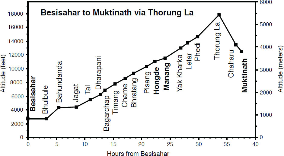
The descent from the pass is gradual at first and follows the middle of the valley for the first hour. It becomes considerably steeper and keeps to the south side of the valley on scree. The first campsites (14,450 feet, 4404 m) are some 1¾ hours down from the pass. In the dry season, after and just before the monsoon, when all the snow has melted, there is no water available. The nearest lodges are at Chaharu (also known as Phedi, 13,688 feet, 4172 m), 2¼–2½ hours from the pass. Just as at the other Phedi, there will be no one here in the middle of the winter—if you are coming up from Muktinath at that time, ask there first as to whether these lodges are operational.
About 10 minutes from Chaharu, fork left and in 20 more minutes cross a major tributary on a long suspension bridge (12,740 feet, 3883 m). The wall-ensconced temple of Muktinath lies 15 minutes beyond. The motor road reaches all the way to the temple, and from this point there will be motorcycles and jeeps.
Another 15 minutes beyond the temple (1 hour from Chaharu), reach the village of Muktinath/Ranipawa (12,047 feet, 3672 m), with an ACAP Safe Drinking Water Station. Muktinath and environs and the route down are described above in the Kali Gandadki/Thak Khola section.