Two roads diverged in a wood, and I, I took the one less traveled by, And that has made all the difference.
—Robert Frost
This chapter is divided into three sections. Treks in the Cultural Trails section have settlements along the route with home stay, community lodges, or hotels available. Routes listed in the Backcountry Treks section will also pass through settlements with similar facilities; however, these treks will at some point involve full self-sufficiency in camping, food, and fuel, for at least one night and longer depending on the route. A third section offers additional suggestions for eco-trekking in beautiful, unheralded areas.
The routes in this chapter are not for everyone and often far from outside, modern help. Considerable resilience is needed, along with a spirit of adventure and an open mind. For a first trek, it is best to consider a more established route (see Chapters 6, 7, and 8). As your experience and ambition grows, you can take on these more adventurous treks and beyond.
People often ask about how to get away from crowded routes that at times can seem to be nothing but a series of hotels, albeit majestically draped with extraordinary natural appeal, yet often with meager cultural interaction. Rural Nepal is rich in heritage; traveling away from the main tourist track and visiting nearly anywhere in the mid-hills and higher can be an immensely worthwhile endeavor. The hospitality of the hill people is unmatched, as is their spirit, and many of these areas remain relatively untouched by modernization. There are few lodges or facilities set up strictly for tourists, and trail sections may be difficult to follow; physical comfort is at a minimum. The rewards are meeting the hill people in traditional settings where often your only option will be to stay in a home, giving ample opportunity for interaction and cultural insight. With that in mind, we are tempted to say, pick any place on the map and go (or do not even bother with the map)! However, this would require more than a little experience as well as mental flexibility, endurance, and minimal language facility. You would have to arrange lodging and food in homes or stay at the occasional basically equipped lodge. If you do this, be prepared for an adventure and for a lack of facilities and ease. Usually, there will be basic to nonexistent toilet conditions. Open defecation is more often than not the ruling practice in rural settings, complicating good hygiene and general sanitation.
Rather than going out completely on your own without a guidebook, you can use the route descriptions in this chapter as a baseline for making this kind of journey. Views of the snow-clad titans might not be as up-close along these routes, but in our belief, the cultural interaction more than makes up for this, and village vistas can be just as inspiring. The rest is to be discovered.
Travelers can find many uncrowded valleys and mountains to explore in Nepal (Photo by R.C. Sedai)
The areas described are generally prepared for the arrival of tourists, and although few visitors might come through, home stay is often readily arranged, and there are also a few lodges along these paths with more facilities being developed.
By choosing one of these treks, you will be choosing to spread the financial benefit of tourism to lower-income areas. As on the more visited routes, we encourage the use of local products along these less-frequented trails. Do your best to eat the same fare as your hosts and support the area’s farmsteads. Avoid packaged, prepared foods, which contribute to refuse that locals do not know how to deal with adequately, especially away from the main trekking venues. (Garbage is disposed of openly in villages, or otherwise stockpiled in a few locations to rot or be burned.) Be aware that monosodium glutamate (MSG), known as TesTi pauDar (i.e., tasty powder) or aajinomoTo in Nepal, may be in use, even in far-flung villages; if you prefer food without this “flavor enhancer,” you can request that it not be added.
Without electronic devices impinging, there can be more interactions with people. Along the less-frequented trails, most locals will be enthusiastically pleased at your presence and will naturally be curious about who you are. Do not be surprised if you are asked many questions. We have explored Nepalese culture in depth in Chapter 3, offering guidelines for interaction. Often people will try to get your attention as you walk the trails by shouting, whistling, or yelling “Namaste!” from afar, or even singing. They might be trying to signal you if they think that you are going the wrong way, or they might just be excited to see you because foreigners in rural Nepal are few and far between outside of the usual routes. If the latter, try to take it in stride and realize that it is a genuine expression of interest in your presence. Most Nepali people feel that it is an honor to have a visitor.
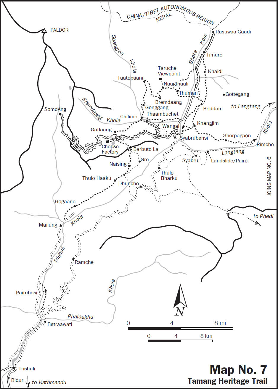
The Tamang Heritage Trail, developed and launched by the United Nations along with the Tourism for Rural Poverty Alleviation Program (UN/TRPAP) in 2005, lies west of the Langtang valley. This route takes you through mainly Tamang villages in the mid-hills that receive considerably fewer tourists than the traditional, adjoining Langtang trek (described in Chapter 8). Although the mountain views are a bit farther away, home stay enables a deeper cultural experience than can be had on the more established routes. Additionally, a trek along the Tamang Heritage Trail can be combined with the Langtang valley trek. The routes coincide at Syabrubensi or along the high route from Syabrubensi to Rimche where the trails tie in at the village of Khangjim.
The usual starting point is either Syabrubensi (one starting point for the Langtang trek as well) or Thaambuchet. There is a daily direct bus from Kathmandu to Thaambuchet; otherwise, three buses depart daily for Syabrubensi from the Baleju Bus Park (also known as Gongabu and New Bus Park).
The road rises out of the Kathmandu valley to the northeast. Enjoy refreshing sights of fertile hills along the way and the occasional symphony of cicadas (if they can be heard over the din of the bus). There are glimpses of Ganesh Himal and west to Himal Chuli and the Annapurna Range. Trishuli is a large town and the administrative center of Nuwakot District, and is less than 45 miles (70 km) (3–4 hours) by road from Kathmandu. From Trishuli, the paved road turns to a dirt road soon after climbing out of Trishuli toward Betraawati (BetrAwati) 5 miles (8 km) away. To avoid the 6–8 hour bus ride over a rough dirt road to Syabrubensi (39 miles or 63 km from Trishuli) via Dhunche, an option is to start the trek from Betraawati, and then meet the Tamang Heritage Trail at Gatlaang village in 3 days. This ambitious choice is described first below, while the details for Syabrubensi, the typical starting point, follow. Since villages along this route rarely see tourists and there are minimal facilities along this portion, it is better to start from Syabrubensi unless you are an experienced trekker with some language facility.
To take this option of walking in (a journey of 3 days), disembark at the bus stop at Betraawati (2050 feet, 625 m). (Alternatively, a single, daily bus plies this track between Kathmandu to Pairebesi, a village 1 hour’s walk ahead, from the Maccha Pokhari/Baleju Bus Park area leaving at 11 AM. The return trip leaves Pairebesi daily at 9AM. Bus times are subject to change.) Take the bridge crossing the Phalaakhu Khola to the north side where a sign announces your entry to Rasuwaa District, the location of Langtang National Park and the Tamang Heritage Trail. Rasuwaa District is named after a fort located at the border with Tibet. Over 60 percent of the inhabitants of Rasuwaa are Tamang.
Follow the road as it inclines to the left/west. A short distance (500 feet, 150 m) from the bridge, a trail to the left breaks away from the road to Dunche, which keeps climbing slightly. Follow this trail to the left, a wide double-tracked trail which drops down from the road and contours above the nearby Trishuli Khola.
In 10–15 minutes you will come to a suspension bridge across the Trishuli Khola. You can cross here to walk up the west side, then cross the Salaakhu Khola on another suspension bridge to tie in with the east-side route near Pairebesi. Otherwise, keep walking up the east side of the river, passing through the fields and houses of KaidaleTaar village, following the wide double track along the east side of the Trishuli Khola. The trail gradually rises to the village of Pairebesi (2230 feet, 680 m) 1 hour from Betraawati. Simple lodges are available in Pairebesi.
From Pairebesi, take a suspension bridge to the west bank of the Trishuli River to more houses and simple lodges. You can take an immediate right to pass a row of shops, then find your way through fields along the Trishuli Khola while gradually rising to Shanti Bazaar (2460 feet, 750 m) with several restaurants and shops. Otherwise, continue straight from the bridge and head right on the dirt road that leads up to Shanti Bazaar in 20–25 minutes. (Two daily buses ply the road on the west side of the river from Maccha Pokhari/Baleju Bus Park area in Kathmandu to Shanti Bazaar. The road from Shanti Bazaar continues to Mailung, but there is currently no regular vehicle service. Road construction along this valley bottom all the way to Syabrubensi is underway. The plan is for a road that avoids the climb to Dhunche by following the river all the way to the border with the Tibet Autonomous Region.)
Reach Simle (2493 feet, 760 m) in 20 minutes from Shanti Bazaar while traveling alongside the Trishuli Khola. There is good camping about halfway between Shanti Bazaar and Simle in a low-lying area near the river. From Simle, the wide track continues to contour along the Trishuli Khola for 15 minutes before climbing and then descending gradually back to the river level. As the path gradually ascends along the river, with cliffs occasionally overhanging the path, you’ll pass splendid rock walls and waterfalls on both sides of the valley. On the opposite side of the river are magnificent multilevel waterfalls that have cut deeply into the rock over the years; changes in the course of the waterfalls can also be traced from the scars left behind by the previous watercourses.
One hour from Simle is ChipleTi, with landline phone service and simple lodging. A little farther along, 1 ¼ hours from Simle, is Mailung (3035 feet, 925 m), a larger village than ChipleTi with a few lodges and landline phone. From here up the Trishuli Khola valley, snowy peaks in the Langtang range can be seen.
Keep to the double-track road and approximately 650 feet (200 m) from Mailung, take a trail that branches to the right, dropping from the road to cross the Nyam Khola on a wooden bridge. The service road not taken is part of the Mailung Khola hydropower project and continues ¾ mile (1.2 km) farther up the Nyam Khola.
After crossing the Nyam River, the route passes over a former rockslide and follows the Trishuli River. In 20 minutes take the trail to the left to abruptly ascend away from the river. (Just near this fork there is a basket-and-pulley system for crossing the river to a trail on the other side that leads to Dhunche.)
The trail to Gogaane heads directly and steeply up the side of the hill before contouring and ascending more gradually up the Trishuli Khola valley. It is an isolated area with no water sources from the point of departure near the river until reaching Gogaane. In 1 hour 20 minutes the trail forks (10 minutes before reaching the village); the upper trail climbs steeply and enters Gogaane past a school. From here it is necessary to pass through people’s front landings (porches) to continue; the lower trail passes below the village and ties in on the north side. Gogaane (4888 feet, 1490 m), a Tamang village, is reached in a little over 1½ hours from Mailung. This picturesque and rustic hamlet, with houses decorated by simple paintings around the front doors, sees few foreign visitors. There are no facilities in Gogaane.
Water is scarce between Gogaane and the next settlement, Thulo Haaku, with no facilities, and few people encountered other than herders and those out collecting wood. From Gogaane, avoid the trail that drops down steeply to a suspension bridge over the Trishuli River and on to Dhunche; instead, follow the trail that contours and climbs above the valley. About 1 hour from Gogaane the trail levels off and then drops down slightly to cross a stream. Near the stream there are several large overhanging rocks favored by herders that provide shelter suitable for camping or getting out of the rain if necessary.
From the stream, the trail ascends out of the canyon and climbs steeply to a ridge, then steadily ascends while contouring north up the Trushuli Khola valley. About 30 minutes beyond the stream, you round a ridge to a view of several snow-capped peaks from the Langtang range, including Langtang I, II, and Kimshung. Pass the open, communal latrine along the side of the trail as you reach Thulo Haaku (6890 feet, 2100 m), in 1½ hours from the stream (2½ hours from Gogaane). (If doing this trail in reverse, from Thulo Haaku to Gogaane, then avoid an upper fork 10 minutes out of Thulo Haaku on the way to Gogaane.)
Thulo Haaku is a large Tamang village with simple facilities, including a post office, monastery, secondary school, and view of Langtang peaks. Landlines that will reach overseas are available here, and some mobile networks are covered. Houses here have elaborate carvings around the doors and windows, mostly of Tibetan Buddhist motifs. The small monastery is above town nestled in a copse of trees including several grand junipers. Across the valley, the road to Dhunche can be seen about the same level as Thulo Haaku, and farther up the valley along a ridge, houses of Dhunche can be seen.
From Thulo Haaku, take the upper trail from the high end of the village. Next is Sano Haaku, visible up the valley. The first section of trail out of Thulo Haaku is a communal latrine, as on the other end of the settlement. Contour over a boulder-strewn stream and cross several more streams, some with water-powered mills and one with a cascade that is ideal for a waterfall shower.
Reach Sano Haaku (6562 feet, 2000 m), also a Tamang village, in approximately 25 minutes. There is an elementary school here along with a police post. Some of the houses have elaborate carvings around windows and doors, as in Thulo Haaku.
Funerals can be observed in the city and countryside at any time. Most Nepalis burn the dead, preferably at the riverside (ghaaT), within a few hours of death. Hill villagers, far from the river, prefer prominent hillsides on which to burn or bury the dead. Rai and Limbu tend to bury. The other ethnic groups prefer cremation. |
Funeral parties are obvious from the presence of a white-shrouded corpse carried on a bier either prone or bound tightly into a sitting position. Male relatives at the funeral typically shave their heads; women frequently loosen their hair, letting it hang unadorned down the back. Drumming is uncommon, except on the occasion of postfunerary ceremonies held sometimes months after death to celebrate the passage of the deceased’s spirit into the afterlife. Such post funerary rituals are common, for example, among the hill ethnic groups such as the Gurung, Tamang, and Thakali. These are occasions for great feasting, dancing, drinking, and serious and ancient religious rituals conducted by shamans and Bon or Buddhist monks. Such postfunerary events are sometimes known in Nepali as arghun in the hills of west and west-central Nepal.  |
Follow the trail to the north from the upper part of town, to reach a rock imprinted with a mantra in Tibetan script in large colorful letters. The trail forks here with the lower fork leading to a village named Gre (described below as an alternate route). Take the upper trail to go on to Naising and the Balbuto Pass before descending to Gatlaang, a village on the Tamang Heritage Trail.
This path is less direct and takes longer than Sano Haaku to Naising to the Balbuto Pass.
At the trail juncture outside of Sano Haaku near a large rock with “Om mani padme hum” written in large and colorful Tibetan script, take the lower trail to Gre. The trail travels up the valley high above the Trishuli River, passing down through a canyon below Naising and crossing a stream on a concrete bridge before ascending out the other side of the canyon, continuing with occasional steep drop-offs at the trail’s edge.
Cross a final ridge and pass chorten before descending slightly to Gre (6562 feet, 2000 m) in 1½ hours from Sano Haaku. Gre is a Tamang village with few facilities other than a tea shop, school, and a gomba as well as a Christian church.
From Gre, a trail to Dhunche/Bharku heads east out of town and drops to the river. The steep trail to Syabrubensi can be seen across the way on the opposing hillside to the north. Perhaps unbelievably, this trail ascends up and over that ridge to the north before descending to Syabrubensi.
To head to Gatlaang, follow the trail west out of the village. It ascends steeply to Balbuto Pass, reached in 1½ hours from Gre. 
To continue to Naising, after approximately 30 minutes from Sano Haaku reach a ridgeline with a mani wall. Just beyond more mani walls is the town of Naising, a predominantly Tamang village with a Christian church established in 2003 which sits above the trail. According to locals, many people in the village fell sick and some were dying during the year 2000, and this period coincided with a visit by a Nepalese missionary. He was able to convince the villagers to convert from Buddhism to Christianity to avert further health problems.
From Naising, do not take the trail from the high end of town which leads up to grazing areas. Instead, the trail emerges from the lower edge of town and immediately forks. The trail to the right drops down to the village of Gre. Take the upper fork that snakes through fields on the way to Balbuto Pass and the Tamang Heritage Trail.
After approximately 15 minutes of gradual descent from Naising, the trail passes a few huts used for milling as it crosses a stream on a wooden bridge. The trail then begins climbing out of the canyon. After approximately 10 minutes from the bridge, avoid a faint fork that again heads to Gre. Stay on the main upper trail, which climbs steadily and steeply to the ridge top above.
Cross the ridge (8218 feet, 2505 m) and then climb gradually through a broad-leaf forest to a mani wall at a pass (8628 feet, 2630 m). From the pass, Gatlaang can be seen below as well as the road to SomdAng. Leave the Trishuli valley here as the trail drops down steeply to then wind along the hillside. Avoid any forks to the right that head directly to the village of Godam.
The trail passes through a few fields to emerge along the road from Syabrubensi to lead and zinc mines at SomdAng). At the point the trail meets the road, the village of Godam is approximately 450 yards (400 m) down the road itself. To continue to Gatlaang, cross the road; approximately 25 yards/22 m up on the other side of the road, the trail drops away from the road, down to the cluster of houses of Gatlaang (8415 feet, 2565 m) approximately 10–15 minutes away from the road crossing and 2¼ hours from Naising.
Gatlaang is an impressive Tamang village on the Tamang Heritage Trail with closely linked houses with slate roofs. Gatlaang also has a Christian church (missionaries have been afoot in this area) as well as a school and a post office. There are two lodges here, one privately run at the top end of town and a community lodge toward the bottom. Guides can be arranged at the upper lodge. Home stay is also encouraged in this village.
The church is above the settlement by the school. Much higher above is a Buddhist gomba and farther above the valley and high above Gatlaang is an army post. A side trip from Gatlaang up to the gomba and a nearby sacred pond and cheese factory is described below.
If weather permits, the Lantang peaks are vibrant from Gatlaang. Landline phone is available here, and power sockets for charging batteries, mobile phones, and more are available in the lodges.
A bus from Syabrubensi to Thaambuchet departs Syabrubensi between 4:30 and 5 PM after first arriving from Kathmandu. The curvy road travels from Syabrubensi at 4813 feet (1467 m) and zigzags up over a pass at 7175 feet (2187 m) and down to Thaambuchet at (5800 feet) 1768 m.
Rather than take the bus, a recommended option is to hike from Syabrubensi to Thaambuchet. To do this, follow the motor road toward Tibet from the north end of Syabrubensi and along the west side of the Bhote Kosi.
Just before the road drops to cross the Chilime Khola and then the Bhote Kosi, the trail heads left/west from the road up through a canyon of the Chilime Khola valley. First pass through fields near a dwelling before dropping down to cross the Chilime Khola on a suspension bridge in 45 minutes from Syabrubensi.
Backstrap looms and local wool allow for the weaving of blankets in an environmentally sustainable way. (Photo by Mary Anne Mercer)
From the bridge, follow the trail upstream/left (rather than to the right, which heads to Thuman). The trail ascends to cross a ridge and then contours to cross another nearby ridge where it then forks. The lower fork is more direct to Thaambuchet but through an area prone to landslides, and the trail might be difficult to follow. The upper fork heads to Paajungbensi (Lower Paajung) with few facilities, and from here it drops back down to the river to meet the lower trail to Thaambuchet (or continues higher along the way to upper Paajung, Bremdaang, and Taatopaani).
Eventually, reach a long suspension bridge to cross back over to the south bank of the Chilime Khola in 1 hour 10 minutes from the previous bridge over the same river. On the other side of the bridge is the small Newar village of Goljung Besi (Lower Goljung) with an unusual predominance of Christians. The village of (Upper) Goljung is high above on the hillside.
Looking back from the south side of the bridge, on the other side of the river, you will notice a large Christian cross mounted atop a hillock, an unusal sight in Nepal. On a plateau just above Goljung Besi is a church as well as the neaby ruins of a former palace. Villagers say that the ruins are of an estate of a Newar king predating Prithvi Narayan Shah, the king from Gorkha District who conquered and united Nepal in the 1760s. The large, dilapidated stone structure is surrounded by fields along with more ruins built up around a nearby pipal tree (a sacred fig, Ficus religiosa). The Bodhi or Bo Tree, the tree which sheltered the Buddha as he achieved enlightenment, was a pipal. These trees are considered sacred to Hindus and Buddhists alike and have characteristically heart-shaped leaves. To reach the ruins, take the trail out of Goljung Besi that ascends toward Goljung. Then head right/west away from the trail and through fields past the church to the ruins beyond.
To head directly to Thaambuchet from Goljung Besi, the trail follows from the long suspension bridge to the right along the Chilime Khola. Eventually you pass the hydropower project just before reaching the village of Thaambuchet (5775 feet, 1760 m) in 30 minutes, less than 2½ hours from Syabrubensi. There are lodges here, and electronic items can be charged. There is also a health post in the village. Tibetan refugees inhabit the upper part of town. A motor road with bus service reaches as far as Thaambuchet. Daily service includes a bus from Thaambuchet to Syabrubensi and on to Kathmandu, leaving at 7 AM; and a bus to Thaambuchet leaving Kathmandu at 6:30 AM from Baleju Bus Park.
Thaambuchet lies at the confluence of the Bremdaang Khola and the larger Saangjen Khola, and is also the location of the Chilime Hydro Power Project. From Thaambuchet, cross over the Bremdaang Khola on a suspension bridge at the upper/west end of town and pass through fields to a long mani wall. Head left/southwest at the mani wall and reach a wooden bridge to again cross the Bremdaang Khola and follow the trail upriver before ascending steeply through a forested area. (Another route continues to follow the river, crossing it a few times before steeply ascending to Gatlaang.)
Reach a large boulder with arrows pointing the way. Gatlaang can be seen up the valley. The scenic trail eventually emerges from the woods into fields and gradually ascends to Gatlaang, passing many chorten and mani walls along the way. Reach Gatlaang in 1 hour 35 minutes from Thaambuchet.
 Side Trip from Gatlaang to Parvati Kund and a Cheese Factory. The trail ascends from the upper part of Gatlaang village, passing mani walls and then crossing a road. From there you ascend along a stream for a while before reaching a so-called “abandoned village” in 15 minutes. Many of the stone houses here are in ruins while some of the houses are still occupied. Keep ascending and reach Parvati Kund (8202 feet, 2500 m), in approximately 40 minutes of steep uphill climbing from Gatlaang.
Parvati Kund is a pond with a stone wall built around it. Inside the walled area is a ceremonial platform, along with a bathing ghaaT and chorten. Outside the rock wall is a rest area as well as a small Hindu temple containing a stone image of the goddess Parvati with Shiva. Two Buddhist chorten are located beside the temple. From Parvati Kund are commanding views of Langtang peaks and the Gosainkund range.
Across the road (which continues to mines at SomdAng) from Parvati Kund is a fenced-in apple orchard, above which sit the remains of a destroyed compound. This was previously a villa of a Nepal Army general that was demolished by Maoists (the general was away at the time).
A 5-minute walk farther along the road will bring you to a few shops. From here, a trail heads right/north to a gomba just above the hill and a nearby, newer, isolated building with a curious signboard that reads “THE COMMUNITY CREATIVITY CENTRE.”
From the left/south side of the road, a trail leads above to a cheese factory in 10 minutes. Cheese and ghiu (or ghee, clarified butter) are produced here to be sold in Kathmandu. This factory is run by the governmental Dairy Development Corporation (DDC).
Return to Gatlaang via the same route. (Another return option from here, if doing the Tamang Heritage Trail in reverse, is to follow the route described above and walk out to the road at Betraawati, 5 miles (8 km) from the large market town of Trishuli.)
Depart for Taatopaani at the bottom/eastern end of Gatlaang. A minute from leaving the village, avoid the branch that heads down steeply toward the river. Instead, continue on the gradually descending trail as it passes through fields and by rows and rows of chorten and mani walls. Pass a final chorten and leave the fields behind to descend through trees to the level of the river. Continue along the riverside, crossing the Bremdaang Khola on a wooden bridge in 1¼ hours. The trail then follows a long mani wall toward Chilime. (Thaambuchet can be reached from a branch that leads right from the mani wall.)
From the mani wall, contour up the Saangjen Khola valley. (Chilime Khola is the name of the river after the confluence of the Bremdaang and Saangjen rivers.) The Chilime Hydro Power Project is visible alongside the river. (Incidentally, electricity for both Thaambuchet and Chilime arrives from Trishuli rather than this large, privately owned project.) Pass by a few houses and lodging in the lower part of Chilime, and then pass the upper settlement of Chilime (6000 feet, 1829 m), an enthralling village to explore, about 1½ hours from Gatlaang. Unfortunately there may be a profuse amount of litter along the walkways.
The trail passes below Chilime to reach a suspension bridge over the Saangjen Khola within 20 minutes from crossing the wooden bridge over the Bremdaang Khola.
From the east/far side of the bridge, do not ascend, but take an immediate left to follow the trail upriver for a couple of minutes before heading away from the river up through fields. After crossing through the fields, the trail branches. Take the wider trail to the right to ascend steeply. As you ascend, the houses of Chilime can be seen below as well as a bird’s-eye view of the Chilime Hydro Power Project and the nearby settlement of Thaambuchet, and farther beyond Thaambuchet, the village of Goljung on the far side of the valley.
Reach Gonggaang (7300 feet, 2225 m) in 1 hour from the Saangjen Khola crossing. Lodging is available. (From Gonggaang, a high trail contours down and out of the valley to the village of Paajung, and on to Syabrubensi.) Follow along the trail from the upper end of the village and ascend to round a ridge from where Taatopaani is visible high up the valley. Continue ascending through fields and trees for 1 hour to reach the collection of lodges known as Taatopaani (8530 feet, 2600 m), built around a well-developed hot springs bathing area. (Taato means “hot” in Nepali and paani is “water,” in other words “hot springs.”) Above the lodges is the eponymous bathing area with six spouts (two each for three bathing pools) and there are dingy changing rooms nearby. Drains have to be closed before the bathing pools fill up. Keep an eye to belongings, as thieves have been known to strike here while unsuspecting bathers are enjoying the warmth of the water. Solar power is available in the lodges along with landline phones. A 5-minute walk to the northwest provides an inspiring view up the Saangjen Khola valley with a beautiful glimpse of snow-capped peaks of the Kerung Range in Tibet.
Meet the trail onward to Bremdaang by the bathing area above the lodges. Bremdaang is at a higher elevation than Taatopaani and back down the valley. Gray langurs, also known as Hanuman langurs, are an old-world monkey and likely to be seen in this forested area between Taatopaani and Bremdaang.
From Taatopaani, ascend gradually through the woods, crossing a few small streams, for 5 minutes to where the trail forks. Both branches lead to Bremdaang. The newer trail heads right to contour more gradually, while the older trail ascends steeply for 5 minutes before contouring and dropping down slightly to a meeting point with the new trail after approximately 10 minutes.
Continue to climb through the woodland, cross a small open meadow, and shortly cross a small stream and reach a fork in the trail just beyond, 30 minutes from Taatopaani.
A painted sign on a rock with an arrow pointing the way to Naagthaali might be visible. Follow the sign to take the trail to the left and ascend steeply through a forested patch to reach a rock wall surrounding the fields that abut the village of Bremdaang.
The trail passes between this wall and a large boulder topped with prayer flags. Follow along the wall to the village of Bremdaang (9350 feet, 2850 m) 1 hour from Taatopaani. (Along the wall, just before reaching Bremdaang, a trail from below joins the trail from Taatopaani. If doing this route in reverse, avoid taking the trail down to the left, but continue to follow the wall to where the trail passes between the wall and a large boulder.)
Basic lodging and solar power are available in Bremdaang as well as phone service. There are elaborate carvings around the windows and doors of the houses here. A small gomba sits above town, along with a built-up viewpoint area where Paldor Peak can be seen. A large prayer wheel stands beside the entrance of the gomba. If the doors are locked, a villager can help locate the key.
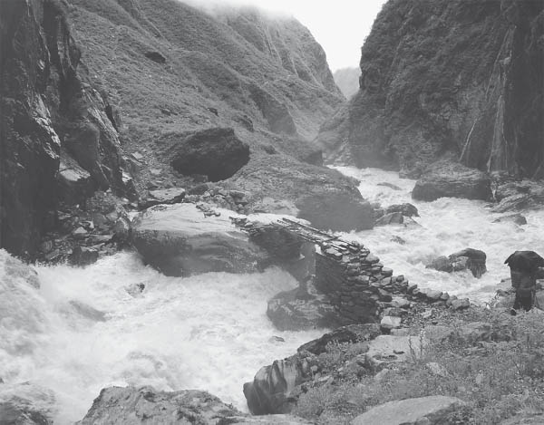
Streams swell to powerful torrents during the monsoon season. (Photo by R.C. Sedai)
The trail to Naagthaali emerges from the upper part of town and winds through the trees to round a ridge with views available of the adjoining valley. The trail follows this ridge from which the Trishuli River valley can be seen as well as settlements along that valley including Dhunche. Reach a large open meadow named Naagthaali (10,640 feet, 3243 m) with a scattered collection of well-furnished lodges in 50 minutes from Bremdaang.
Look for chAUmri here, a cross between cows and yaks. Two small gomba, the older stone structures surrounded by prayer flags, are located in Naagthaali; one lies at the high end of the meadow and the other is more centrally located. If the lama of either is present, he might let you into a throne room with Buddhist iconography. Do not be surprised if a monetary request is made. (Keep in mind that it is customary to leave a small donation when visiting religious sites.) There are caves nearby that locals say have long been used for meditation. You might need a local guide to find them in the area above and behind the uppermost lodge and higher gomba at the high end of the meadow.
Side Trip from Naagthaali to Taaruche Viewpoint. As advertised on a sign at a Naagthaali lodge, “VISIT TARUCHE WITH KALEIDOSCOPE VIEWS OF GANESH HIMAL RANGE, KERUNG RANGE (TIBET), LANGTANG HIMAL RANGE AND GOSAINKUND RANGE.” To reach Taaruche, the trail leads away from the upper end of the meadow and passes below the higher gomba. Follow the trail to ascend through pine forest, and keep to this wide trail along the ridge overlooking the Saangjen Khola valley with occasional vistas through the trees. At one point the village of Taatopaani can be seen below.
On the way to Taaruche, there is a small, seasonal cheese-making operation in a hut among the trees below the trail. Milk is gathered and hauled up from chAUmri herders around Naagthaali, and their products are sold locally and in Kathmandu.
Emerge from the trees to contour away from the valley rim and up through open hillside, then ascend to round another ridge and pass through a lush grove of moss-laden trees including rhododendron. Water is likely to be available here. Pass out of the trees and round another ridge to reach the top of an open ridge. This area is known as Taaruche (12,224 feet, 3726 m), reached in 1½ hours from Naagthaali, marked with prayer flags.
Here you will find nearly 360° immense views (if Mother Nature cooperates) and a herder’s seasonal shelter. No facilities are available, but keep a lookout for grazing chAUmri. Mountain views north to Tibet, as well as west to the Ganesh Himal Range and Paldor Peak, and east to the Langtang range, are sensational. No sounds impinge but those of birds, insects, the rustling of the wind, and perhaps the occasional jingle of a bell on a grazing animal.
Note that from Naagthaali to Thuman, the trail can be unclear with several diversions. Catch the trail to Thuman at the lower end of the meadow. The trail here might be difficult to follow given the amount of heavy-footed ungulates plodding around the soft earth in a slow, never-ending search for fodder. Descend while heading northeast, and after approximately 5 minutes the trail to Thuman branches off to the right/east. This might be easy to miss as the widest trail may seem to continue on straight/northeast, but it only descends to a pasture in a few minutes where it then becomes a maze.
The right fork heads down through a grove of trees with abundant rhododendron for a few minutes, then straight across an open area (the aforementioned pasture area labyrinth is up to the left/north). Continue heading straight to descend through forest. In 30 minutes from Naagthaali, the trail emerges to cross a large, splendid meadow and continues its descent.
In another 15 minutes the trail forks. Continue straight (rather than left) and down through fields above Thuman. Pass by a school on the right and arrive at Thuman (7546 feet, 2300 m) in 1 ¼–1 ½ hours from Naagthaali. Thuman is a large Tamang village with closely placed houses and elaborate wood carvings around doors and windows. Lodging and a health post are available here.
A gomba lies at the lower, southern end of town. The konyer, or keyholder, lives nearby. If you approach closer, be aware that a swarm of bees have made a home near the upper part of the gomba’s inner door. Trails to Taambuchet and Chilime up the Saangjen Khola valley and to Syabrubensi leave this end of town. A trail to Taatopaani that bypasses Naagthaali also branches off the same trail to Chilime. Thuman offers excellent views of Langtang. The settlement is powered by hydroelectricity from a nearby stream, and sockets are available for charging batteries, phones, and other devices. However, electricity is usually only available from evening to morning (6 PM–6 AM).
The Tamang Heritage Trail offers two options from Thuman. One route is to travel north to the border town of Rasuwaa Gaadi along the trade route with Tibet and then return to the village of Briddam opposite Thuman on the other side of the valley. Another option is to head directly to Briddam from Thuman. The direct trail will be covered as an alternate route, then we will cover the longer option via Rasuwaa Gaadi.
Be advised that some maps need updating for this route, which steeply descends from Thuman at 7546 feet (2300 m) to the bridge over the Bhote Kosi (5151 feet, 1570 m) and up the other side of the valley to Briddam (7218 feet, 2200 m).
From the gomba at the southern end of Thuman, find the path heading down just to the north/village side of the gomba. Descend along a ridge past a series of mani walls. (Another trail leaves from the middle of Thuman just below the health post between a lodge and house. As it exits town, follow the right fork, which meets up with the trail from the gomba in a few minutes to descend along the ridge.)
Reach the lowest mani wall in 15–20 minutes. The trail to the Bhote Kosi and on to Briddam via Ling Ling village drops down from the left side of this mani wall toward the ridge line. From the ridge line, fork left/north away from the ridge and down through the trees in the lush gully below the fields of Thuman. Rhododendron is abundant here. (The right/south fork from the mani wall descends down through the Bhote Kosi valley to Syabrubensi.)
Reach the bridge over the Bhote Kosi in less than 1½ hours from Thuman. Ascend from the bridge, and reach the lower end of the village of Ling Ling in 15 minutes. To ascend to Briddam, find the trailhead after passing a mani wall and lodge and before reaching a small stream. The route passes behind a house, then ascends between two more houses, through a field, and steeply up to a group of prayer flags. In 40 minutes the trail meets the trail from Timure that bypasses Ling Ling. Keep ascending and round another ridge with chorten. Briddam can be seen over on the other side of the hill. Drop down steeply to cross a stream over a cement bridge. Pass through trees and ascend up to Briddam in 3¼ hours from Thuman.
Corn, a staple mid-hills crop, is sometimes roasted at the hearth and eaten plain. (Photo by Alonzo Lyons)
The trail from Thuman to Daahaal Phedi leaves from the north end of Thuman, contouring through the fields to the north. The trail passes old mani walls and in 15 minutes crosses the stream that is the source of electricity for both Thuman and Daahaal Phedi; the small hydroelectric station can be seen above. Continue along the hillside, passing more old mani walls, to round a ridge. The trail climbs steeply along a path cut into the stone face of the hill. Round another ridge with a mani wall and descend to a fork in the trail. A rock here has a painted sign pointing the way to “DALPHEDI/TIMURE,” the upper trail, or “TIMURE,” the lower trail circumventing Daahaal Phedi.
To continue on to Daahaal Phedi, take the upper route, eventually climbing steeply to cross another ridge marked by a chorten. From here, the town of Timure can be seen up the other side of the Bhote Kosi river valley, as well as the road to Tibet. The trail then descends to Daahaal Phedi, passing below the school, reached in 1 hour 10 minutes from Thuman. Daahaal Phedi is a small Tamang village with scattered houses and few facilities. Continue down from the village, passing houses and then dropping through fields directly toward the river below. Reach a resting point marked by a tall wooden flagpole in 15 minutes.
(To bypass Daahaal Phedi for a more direct route to Timure, take the lower route at the junction en route from Thuman, marked with the painted rock sign indicating “TIMURE,” branching right to head downhill and around the hillside. Avoid any forks to the right that descend to the river. This route eventually passes below the houses of Daahaal Phedi. In 40 minutes the two routes tie in again near the resting point below Daahaal Phedi, marked by a tall wooden flagpole.)
From the resting point, the trail descends steeply to the Bhote Kosi to reach a suspension bridge in 30 minutes. On the other side of the river you enter the Langtang National Park, as indicated by a park sign. From the bridge, head upriver shortly before ascending to the motor road above through rubble created in making the road. In 15 minutes from the bridge there is a built-up hot springs area (to the left/river side of the road) with three concrete pools built in the summer of 2009. Do not be surprised if the water is too hot for bathing; perhaps a way to cool the pools will be established in the future. Other problems at these and other hot springs include people washing clothes with detergent and leaving rubbish which accumulates and becomes unsightly. If you are hoping to find a glorious bathing spot, you will likely be disappointed.
Follow the road to reach Timure in 40 minutes from the suspension bridge over the river or 2½ hours from Thuman. Timure (5781 feet, 1762 m) is a prosperous village with ample lodging and phone service and many facilities including a health post, school, army post, and police post. Sockets are available and electronic equipment can be charged here. However, hydroelectricity from the GhaTTe Khola is only available from evening to morning, approximately 5 PM to 9 AM. Solar power is also available when the hydropower is offline. Timure has long prospered as a hub of the ancient trade route from Tibet, as well as being along the new motor road. Large, whitewashed mani walls line the center of the village. The gomba sits just above the settlement. To reach it, pass by the police post along the way.
To continue on to GhaTTekholaa and Rasuwaa Gaadi at the border with Tibet, meet the trail as it leaves the upper end of Timure and follows along the motor road. Reach the army post and checkpost in a few minutes. Here bags are checked; due to sensitivities in the border area, cameras and mobile phones will be confiscated and held until you return, but perhaps not under the safest of conditions.
The road follows the Bhote Kosi to reach GhaTTekholaa in 20 minutes from Timure. To avoid a stretch of the road, a trail leads away from the road just where the fields of GhaTTekholaa begin. This trail passes above the fields and into the village.
GhaTTekholaa is a small, colorful BhoTiya hamlet that does not see many tourists. Most houses have traditional wooden carvings and paintings around doors and windows. The village has hydroelectric power from the nearby stream of the same name; the power plant is just above the road out of town toward Rasuwaa Gaadi.
The mantra “Om Mani Padme Hum” is carved in Tibetan script in big, colorful letters on a large boulder in the center of the village (looking back from the path to the Timure side). A school and a gomba are at the top end of the hamlet, and there are a few shops but no other facilities here. Glimpses of snowy peaks can be seen from the village up the GhaTTe Khola valley.
A trail out of the upper/north end of the village crosses a suspension bridge over the GhaTTe Khola and then drops down to the road, which continues to follow the river up to Rasuwaa Gaadi (5955 feet, 1815 m), reached in 20 minutes from GhaTTekholaa.
Rasuwaa is the name of a fort built in this area in 1912. Only the foundation remains. The Rasuwaa District of Nepal, which includes the Tamang Heritage Trail and Langtang National Park, is named after this fort. It lies at the confluence of the Lendi Khola and Kerong Khola, which join to form the Bhote Kosi. The road to Tibet passes up through the Kerong River valley. On the Nepalese side, simple lodging is available along with a few shops stocked mainly with Chinese snack foods. An area for camping is available below the shops and the remains of the fort.
There is a suspension footbridge and a bridge for vehicles over the Lendi Khola. Both bridges have gates blocking free passage across. The first gate of the suspension bridge is located midway across the bridge. At this point a Chinese soldier will come to meet you to see if you have proper documents to pass into Chinese territory. The Chinese side is much more built up than the Nepali side and has heavy security in the presence of soldiers.
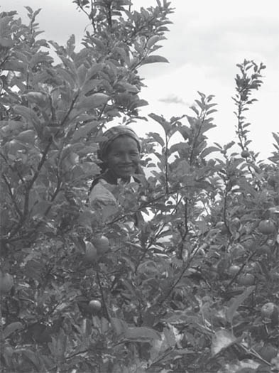
Apples have been introduced at Khaidi village along the high route between Timure and Briddam. (Photo by Tokozile Robbins)
The return route to Timure is the same way, along the road. From Timure, there are two routes to reach Briddam. The lower route begins by following the road back down past the hot springs. Alternatively, there is a high route leaving from Timure village, and if you do not mind a few steep inclines and descents, then this high trail avoids the motor road and is more scenic and is 1¼–1½ hours longer.
To head to Briddam, the trail departs from Timure at the lower end of a mid-village mani wall and passes by the police post just below the gomba. The route follows power-lines most of the way to Khaidi as it ascends steeply uphill before contouring more gradually. Pass below a school before reaching the few houses of Khaidi (7480 feet, 2280 m) in 1¼–1½ hours from Timure. There is a tea shop here and a small veterinary clinic where animal husbandry workshops take place, but few other facilities. Fresh apples, peaches, and plums might be available depending upon the season.
(From Khaidi, a path leads a few hours higher to Gumling, where there is a gomba, and beyond that to a seasonal pasture area known as Braanga Kharka at about 10,500 feet (3200 m), with spectacular views. However, no facilities are available, and trekkers must be self-sufficient in food and shelter to ascend higher from Khaidi.)
Continue onward by contouring and entering a tributary valley. The trail passes above a rock face and then descends steeply down the valley wall to a bridge over the Phenglung Khola in 1 hour.
The route onward from this bridge to Briddam is a lesser-traveled path with relatively few other users. The next section may be difficult to follow, as foliage often closes in on the trail; this also makes it particularly leech-infested during the monsoon season.
Ascend and contour through a wooded area. Be conscientious to follow the widest path, as there are several offshoots to the main trail. The trail eventually rounds a ridge with a chorten and ties in with a lower path arriving from Pelku as it descends to the Briddam Khola. Two bridges span the stream, side by side, one steel and the other cement. From this crossing (over the bridge of your choice), Briddam is a 5–10-minute ascent and 1¾ hours from the Phenglung Khola crossing.
As you follow the motor road from Timure, it is possible to catch a trail that contours along the hillside above the road for some time rather than walking along the road itself. This trail can be found approximately 5 minutes downriver from the hot springs and branches to the left/east side of the road. However, this trail or parts of it will likely come into discontinuance once the road gains prominence.
Follow this trail above the road and river to reach a bridge in 1 hour from Timure. After 30 more minutes the trail branches in two. The upper path ascends to Briddam while the lower passes through the village of Ling Ling, reached in another 5 minutes.
The upper path ascends through the small village of Pelku with a tea shop and simple lodge. Keep ascending and avoid any forks along this trail that head lower. Cross a stream straddled by a prayer wheel and then round a ridge marked with prayer flags. Keep ascending and round another ridge with chorten. Briddam can be seen on the other side of the hill. Drop down steeply to cross a stream over a cement bridge. Pass through trees and ascend to Briddam (7218 feet, 2200 m) in approximately 2¾ hours from Timure.
Briddam is a large village with lodges and many options for home stay. A number is assigned to each participating home-stay house. Signs are posted on the houses with the number as well as the names of the owners. Electricity is available 24 hours per day (power cuts notwithstanding) along with sockets for charging electronic devices.
A health post and primary school are also located here, and a gomba lies at the top of town. Another older and smaller gomba is built around an overhanging rock a few minutes farther up/east from the village. Inside, the main figure is Guru Rimpoche, also known as Padmasambava. To get to this gomba, follow the trail from the central village area up toward the main gomba. The trail branches to the right just before reaching the houses and a community center next to the main gomba, and passes behind the houses and through fields to this older gomba a few minutes beyond.
Side Trip from Briddam Village to Gottegang Kharka. This is a long, arduous day trip from Briddam involving a 3500-foot-plus (1100 m-plus) ascent and return descent. You’ll enjoy breathtaking views from the pasture at the top, while finding no facilities and scant water resources along the way, and few to no other people on the trail.
Find the trail at the top of the village to the right of the houses that lie before the main gomba. Pass behind the houses and to the left of the smaller, older gomba which is just above and marked by prayer flags. The trail ascends to reach a ridge in less than 10 minutes where it forks. Take the lower, left trail down to Briddam Khola and cross branches of the stream twice on wooden bridges before ascending steeply up the opposite hill to cross a ridge marked by prayer flags. Briefly contour to the next ridge and then ascend steeply, following this ridge to pass through lush forest abundant with rhododendron. Eventually, contour northeast through pine, enjoying views west and north along the way.
Reach an open meadow in 2½–3 hours from Briddam. Seasonal goTh huts used by summer herders dot the meadow. Gottegang is considered to be the area at the top of the meadow. However, the trail up becomes overrun by grazing tracks. Take care to notice where you leave the main trail behind so as to be able to find it on return, especially if the weather deteriorates. Make your way up to a large rock at the top of the meadow marked with a cairn and prayer flags for the best views (11,066 feet, 3373 m, GPS coordinates, N 28° 12.537’, E 085° 23.156’). Dhunche can be seen down the valley and Naagthaali and Paldor Peak to the west, as well as the Kerong range to the north in Tibet. From Gottegang, the trail ascends farther to more goTh of Pangsang, but you must be self-sufficient to continue as there are no facilities.
The trail from Briddam to Khangjim departs from the upper, southeast corner of Briddam and ascends gradually to cross a ridge and then passes through an archway in 15 minutes near a rest area. From here, the wide trail gradually descends through forest.
In another 10 minutes (25 minutes from Briddam), reach a fork. The upper trail continues to Khangjim and the upper Langtang valley; the lower trail descends to Wangal and on to Syabrubensi.
To head directly from Briddam to Syabrubensi, where buses can be found to Kathmandu, take the right fork to Wangal and descend through a lush forested area with prime views across the valley of the Chilime Khola. Thaambuchet is the village seen at the head of the Chilime valley, alongside which lies the Chilime hydropower plant. Continue descending through pine, and in less than 1 hour from the junction south of Briddam, the trail narrows and descends steeply for 15–20 more minutes before coming to a fork. The trail to the left ascends past a school and on to Khangjim; the right fork leads down to Wangal (5358 feet, 1633 m) a few minutes below, 1½–1¾ hours from Briddam. Wangal has a tea shop and simple lodge with solar power but no other facilities. The trail to Syabrubensi heads south out of the village. Descend gradually following along the river below and reach the older part of Syabrubensi in 40 minutes.) Here, continue up the Langtang Khola valley (see Chapter 8 for a description) or cross the Bhote Kosi on a suspension bridge to continue on to the newer part of Syabrubensi on the western side of the Trishuli River. A hot springs lies below along the banks of the Trishuli River. It has five concrete bathing pools which may or may not have water but are likely to be in disrepair and a bit polluted.
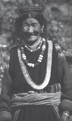 |
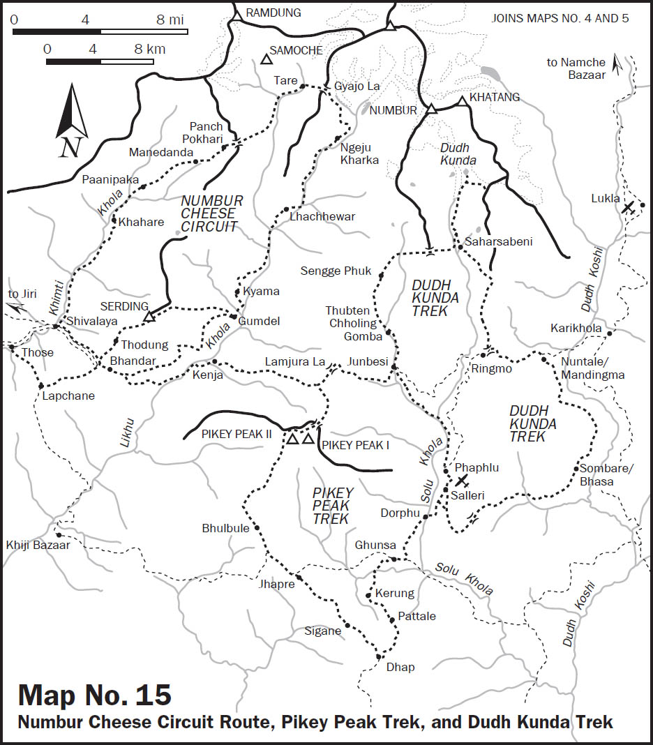
Various necklaces adorn this lady living south of Makalu. |
Necklace designs are shared among many groups. There may be large gold beads, lac-filled for strength and lightness, strung with coral, glass, or layers of velvet circles between them. While the necklaces were once silver, the trend is away from it to gold. |
A tilhari, a long, cylindrical, repoussé gold bead that hangs in the center of a few to a hundred strands of fine colored glass beads (seed beads), is worn by married Hindu women. Red, followed by green, are the most popular color beads. |
The most commonly worn necklaces are composed of multiple strands of small glass beads (pote). With the availability of Czechoslovakian and Japanese beads, color choices number in the hundreds. Necklaces may be choker length with just a few strands, or may hang to the hips and have numerous strands. |
The most significant color is red, the color of marriage and fertility. Among the Hindu castes, the bridegroom placing a necklace of red pote in combination with the application of red powder (sindur) in the part of the hair constitutes the most important act in the wedding ceremony. The red beads are the sign of a woman whose husband is alive. When a woman becomes widowed, the beads are discarded. |
BhoTiya wear big pieces of coral (often imitation) and turquoise (almost always real) as well as large black and white dzi beads. Dzi protect the wearer from stroke and lightning. They are believed to have a supernatural origin as creatures (worms) that were petrified by the contamination of human touch, but retain some of their supernatural power. BhoTiya will also wear small prayer boxes of gold and silver, often with bits of turquoise and fine filigree work. Colored, knotted strings, blessings from lamas, are also worn. |
| Many women wear bangles of gold, silver, and Indian glass on the wrists. Red is the most auspicious color, and the clinking is considered mildly erotic. Ankles are less commonly decorated than in the past. The Tharu in the Tarai may wear hollow or solid heavy anklets. Hill ethnic groups used to wear dragon-like (makar or singha mukh) designs. Anklets display high relief when new, but wear down over the years to become almost smooth. Some may wear similar pieces on the wrist. Gold, a divine metal, sacred to Vishnu, is rarely worn below the waist (the more impure division of the body), so these are usually silver. |
Buses to Kathmandu depart three times daily at 7 AM, 7:30 AM, and the last bus departs around 9 AM after first arriving from Thaambuchet (times are subject to change).
To continue on to Khangjim to meet the trail to the upper Langtang valley, take the upper/left path at the fork which leads to Khangjim. Ascend through forest (avoid trails heading lower) before descending slightly to a ridge marked by a chorten; from here Khangjim is visible a short distance away. Syabrubensi is also visible far below at the confluence of the Bhote Kosi and Langtang Khola which join to form the Trishuli Khola. There are also views up the Chilime Khola valley from this point. Khangjim (7480 feet, 2280 m) is reached in 30 minutes from the junction or under 1 hour from Briddam.
Here the Tamang Heritage Trail ties in with the more popular Langtang trek. Khangjim has satellite dishes, a renovated gomba, as well as abundant lodging, and batteries can be recharged as well. Above town is a Tibetan refugee camp. (See the Langtang section of Chapter 8 for a continuation of route descriptions from Khangjim for either a return to Syabrubensi or a journey into the upper Langtang valley.)
This culturally diverse trail covers beautiful terrain in Nepal’s mid-hills east of Kathmandu. Jointly developed by the Ramechap Economic Development Forum and the United Nations’ International Labor Organization, the trail was “launched” in October 2009 by the Nepal Tourism Board but as of yet has seen few tourists. Ethnicities prevalent along this route include Sherpa, Tamang, Thami, Majhi, Newar, and Yolmo. Among these groups, the Thami and Majhi are rarely encountered on trekking routes. The Thami are unique to this region and, with a total Nepalese population of less than 30,000, their culture is considered endangered. The Majhi, with a Nepalese population under 75,000, traditionally make a living near rivers through fishing and as boat people, mostly in the inner Tarai along the southern belt of Nepal bordering India.
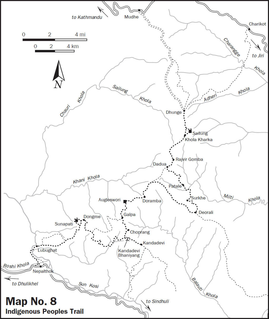
There are community lodges and home stay along the way, providing closer contact with Nepali hospitality and greater insight into ethnic lifestyles than can be found along the more developed trekking routes where interactions are more commercially oriented. This enchanting mid-hills trek is located entirely in the Mahabharat range, with picturesque vantages of the Himalaya at several hilltop lookouts and along much of the route. The highest elevation reached is 10,325 feet (3147 m), thus it is an all-season trek. However, be aware that, despite the relatively low elevation, the first part of the trek takes you to the highest point of the route in a brief period of time, with an attendant risk of AMS. People who feel mild symptoms of altitude illness should descend immediately if symptoms worsen (see Chapter 5 for more information on altitude sickness). At the other, lower end of the route, the last village, Lubughat (1755 feet, 535 m), might be excessively hot, especially outside of the winter months; fortunately it lies along the cool waters of the Sun Kosi.
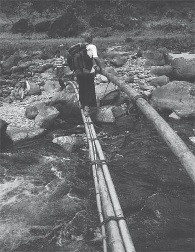
Once off the beaten track there are many different kinds of bridges in use. (Photo by Stephen Bezruchka)
Hindu weddings can be observed almost any time, but most are held during the months of January and February. Wedding parties travel to and from the bride’s house, sometimes over a long distance and for several days. In rural villages, weddings are loud, colorful affairs accompanied by hornpipers, drummers, and dancers. Wealthy city weddings often include professional bands, and the house where the wedding feast is held is decorated with strings of lights at night. Hindu marriages are traditionally arranged by the parents of the couple; horoscopes are compared by a priest, and an auspicious date is set. Dowries are often demanded, and can be quite expensive. Child marriage is now prohibited but still occurs and was traditionally the norm among orthodox Hindus. |
Buddhist weddings in the hills and mountains are less elaborate, more relaxed affairs, with great attention paid to ostentatious display and reciprocity in gift giving. Among Sherpas, for example, a wedding is preceded, sometimes years earlier, by betrothal rites and often by the birth of a child. There is much drinking and dancing. Monks from a nearby monastery attend to the actual ceremonial activities. |
| Today, throughout Nepal, the customs surrounding the securing of a marriage partner are relaxed compared with the past. Love marriage and marriage between castes and ethnic groups are not uncommon. Nonetheless, arranged marriages of alliance between families in proper caste or ethnic categories are regularly contracted, especially among the more orthodox Hindus. |
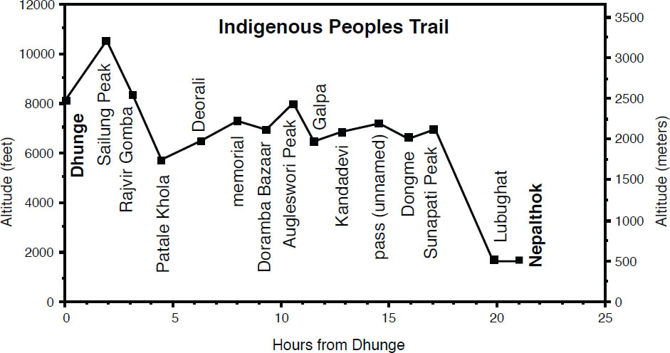
The route lies mainly in Ramechap District but begins in Dolakha District at Dhunge village. A direct bus to Dhunge departs from the Old Bus Park near Ratna Park in Kathmandu between 6 and 6:30 AM (times are subject to change). The road follows the same overland route to Solu–Khumbu up to the town of Mudhe, reached in 4 hours. Here the road diverges along a rough dirt track to arrive at the hamlet of Dhunge (8123 feet, 2476 m) in less than 2 more hours with outstanding views of the broad expanse of Gauri Shankar (the mountain devoted to the God-couple Parvati, also known as Gauri, and Shiva, also known as Shankar) and more along the way. The road continues to Khola Kharka; however, the bus disgorges its contents at Dhunge and goes no farther.
From the bus stop in Dhunge, do not follow the road to the right/south but ascend stone steps to the southeast. Keep to the stone staircase, criss-crossing another road (which leads to a village named Ghaledanda).
Side Trip to Caves. To visit two caves away from the main route, then in less than 20 minutes from Dhunge, follow the road to the left away from the ascending trail. Contour along this road and within 10 minutes pass a home with a workshop for making Tibetan Buddhist idols, which might be on display. Another 15 minutes farther along this road, take a trail that branches to the right just before crossing a small tributary. Follow the trail up this stream and shortly (45 minutes from Dunghe) reach a cave with an aperture in the rock called a “dharma gate.” Locals believe that only the pure in heart are able to climb through the hole (there is another such “gate” at a cave closer to Sailung peak). The trail continues up the stream and in 5 minutes reaches a cave with a stalagmite that is worshipped as a shrine to Mahadev (another name for Shiva) and is purported to drip milk once every twelve years, an event celebrated by the local people.
To continue to Kalopani from here, the trail heads upstream; keep to the right a minute from the cave, then ascend steeply up to a ridgeline (the trail to the ridgeline might be faint and difficult to find). Head left/west along the ridgeline to reach Kalopani) in 30 minutes from the cave.
Continuing along the ascending trail, reach Kalopani (9137 feet, 2785 m) and a tea shop and basic lodging in less than 45 minutes from Dhunge and enjoy a beautiful panorama of the snowy Himalaya to the north and east. The trail continues through rhododendron and pine and in less than 30 minutes reaches a boulder on the right adorned with scarves and flowers, locally known as DAAphe Dhunga, or “rock that looks like a DAAphe” (the DAAphe, or Impeyan pheasant, Lophophorus impejanus, is the national bird of Nepal). As the story goes, residents near Kailingchok Peak, across the way in Dolakha District, were in dispute with those living closer to Sailung Peak as to which peak was higher. To settle the matter, a DAAphe was released from each summit. Both birds flew in a straight line, and the bird released from Sailung passed above Kailingchok, whereas the bird released from Kailingchok reached a level below Sailung Peak. It is said to have landed at the very point of DAAphe Dhunga, and the boulder immortalizes the legend. (Incidentally, Kalingchok is nearly 12,100 feet [3700 m], or some 1800 feet [550 m] higher than Sailung.)
In 5 minutes beyond the boulder there is a junction with a trail leading left to another set of caves. At this junction there is a legend regarding the hillock immediately to the north, regarding a hole in the ground at the top of it. Locals say that the wishes of a petitioner will be fulfilled if the hole can be reached and rounded three times without breathing from the base of the hillock. This is a 50-yard uphill distance at an altitude of nearly 9800 feet (3000 m)!
Side Trip to Caves. Take the left fork from the junction to visit three caves, a round trip of 20 minutes, not including time exploring the caves. In 3 minutes the trail diverges; stay right and then stay right again in 2 more minutes to reach Devithan Cave (9636 feet, 2937 m) 1 minute beyond. The second cave, Meha Devitan, is 2 minutes farther below with a stalagmite believed to emit milk once every twelve years (similar to the cave near Kalopani). Sailung Cave is another 2 minutes below with a “dharma gate” similar to the one near Kalopani, allowing only pure-hearted supplicants to pass through. To return to the trail juncture, follow the same route in reverse.
Continue straight from the junction. Just beyond the junction the trail branches; stay to the right. A few minutes more is a large rock; on its top is the impression of a sword said to have been used for revenge in a case of adultery. Just beyond this rock the trail diverges; again stay to the right. In another 10 minutes the trail forks again. The right fork leads directly to Khola Kharka, bypassing the summit of Sailung. The left fork reaches Sailung Peak (10,325 feet, 3147 m) in 1 hour from Kalopani, passing an adorned rock said to contain Guru Rimpoche’s foot imprints. Enjoy the magnificent views from either the higher peak or rounded slightly lower peak, both topped with chorten. On the lower peak are two other structures, used during festivals. Sailung summit is on the boundary line between Dolakha District and Ramechap District. According to locals, there are over 130 different jaDibuTi (medicinal herbs) found in the Sailung area.
The trail leads down to the south, and just below the summit goes by three rock formations said to represent a tiger, a mother cow, and her baby—the mother cow has come between the tiger and the calf to protect it from being devoured. Khola Kharka (9678 feet, 2950 m) lies 20 minutes below Sailung, with several shops and a well-equipped community lodge just below.
The route continues southwest, following either the road or a trail that crisscrosses the road to reach Rajvir Gomba (8661 feet, 2640 m) in 45 minutes where rooms might be available. Continue along the road to Dadua (8018 feet, 2444 m), a Sherpa village with a thangka painting school run by a Tamang couple, in 30 minutes more. Follow the motor road to the south, and in just over 5 minutes the trail breaks off to the left/southeast from the road to contour through fields on the east side of a ridge. Eventually, pass to the west side of the ridge and then generally follow the ridgeline south before descending to the right 40 minutes from leaving the road. Reach the Tamang village of Patale (6890 feet, 2100 m) in another 10 minutes (under 1 hour from Dadua). There are two small gomba in this village. Continue along the ridgeline for 20 minutes before dropping steeply to the Patale Khola in 10 more minutes. Along the way, avoid a trail to the left that contours around the hill to a suspension bridge over the Tin Dhare Khola, unless you would like a bird’s-eye view from this bridge of a waterfall below it.
Cross the Patale Khola (5725 feet, 1745 m) to its south side; there is no bridge. Just below this crossing, this tributary joins with the Tin Dhare tributary to form the Milti Khola. Ascend steeply, enjoying views of the waterfall on the Tin Dhare Khola across the way. In a little over 10 minutes the trail contours to the southeast. At this point, avoid trails that ascend. Cross another tributary and reach Surkhe (5906 feet, 1800 m), a Newar village in 30 minutes from crossing the river. Home stay has been established here.
Contour to the southeast and cross a tributary in 15 minutes, then take the trail to the left and fork left again a few minutes farther to arrive at the Thami (also known as Thangmi) village of Tin Ghare (6004 feet, 1830 m) in 20–25 minutes from Surkhe. The Thami have their own language, which is of the Tibeto-Burman family and lacks a script. They follow a shamanistic belief system with Buddhist, Bon, and Hindu influences. They are well known for weaving skills, and live mainly in Ramechap and Dolakha Districts.
To continue on to Deorali, head 5 minutes back in the direction of Surkhe up to a junction passed earlier and this time ascend to reach a school (6168 feet, 1880 m) within 10 minutes. Take the trail to the left at the school, then turn right just beyond to ascend along a deeply cut trail. Reach Deorali (6758 feet, 2060 m) in 35 more minutes, 50 minutes from Tin Ghare. Deorali is a small bazaar with basic lodging that sits on a ridgeline along a motor road. Follow the road to the northwest past chorten and continue along the road with trail shortcuts along the way. After 1¾–2 hours from Deorali reach a large memorial (7119 feet, 2170 m) built by the Maoists along the ridge top. This is the site of the so-called Doramba Massacre when the Nepalese Army killed nineteen people, eighteen of whom were believed to be Maoists, in August 2003.
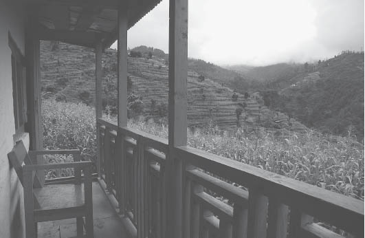
The scene from a balcony of a mid-hills village (Photo by Mark Jackson and Susan Bergin/SAFA Himalaya Collection/Nepal)
The road continues on to Doramba bazaar, but in a few minutes from the memorial take the trail that branches to the left to descend from the road. Cross a tributary in under 30 minutes and stay to the right. Reach Doramba Bazaar (6739 feet, 2054 m) with a simple lodge in less than 30 more minutes, and the village with home stay 10 minutes below the bazaar (3–3¼ hours from Deorali). This is one of the largest Tamang settlements in Nepal. A barbed-wire fence surrounds the gomba, which lies on the west side of the village.
To head to Augleswori Peak and lookout point, you can ascend the hill behind the gomba to the road above in less than 15 minutes and then follow the road to the left. Alternatively, from the main Doramba bazaar, follow straight along the road to the south, passing a health post in 10 minutes. Another 5 minutes brings you to where the trail from the gomba ties in with the road. Ten minutes farther along, the road diverges. Stay with the road to the left, and a few minutes beyond follow the trail that climbs to the left side above the road. This shortcut passes near a small Hindu temple housing a rock Shiva-lingam where animals are sacrificed.
The trail meets back up with the road and continues to make a shortcut of the road along the way. In 30 more minutes reach a point where the trail branches to the right from the road. From here, a large boulder is visible below to the right. The local deity Augleswori Mahadev is believed to reside there. It is a 10–15-minute descent to reach this festooned boulder where ceremonies are performed during festivals.
The road does not reach the lookout point. Instead, ascend on the trail to the right to Augleswori Peak (7887 feet, 2404 m) in 10 minutes (70 minutes from Doramba) with a commanding vantage of the snowy sentinels to the northeast and the Mahabharat range and Tarai to the southwest.
There is a faint path from the lookout point to the southwest that leads down to Galpa. Otherwise, descend back to the road and follow it for 30 minutes to where a trail branches to the right to pass through a serene pine forest as it descends to Galpa (6519 feet, 1987 m) in just over 10 more minutes (45 minutes from Augleswori Peak). Galpa is a busy bazaar at a crossroads. There are restaurants, lodging, and a medical shop here.
Several roads intersect here and it might be unclear as to how to proceed from Galpa. It might be necessary to ask for the way. To continue to Kandadevi, head along the road to the left/southeast from the the point where the trail from Augleswori Peak arrives at Galpa. Descend gently before contouring and reach a few tea shops in 30 minutes. Just beyond you begin to pass through the upper reaches of the scenic, spread-out village of Choprang which overlooks the broad valley below. Ascend to another set of tea shops at a pass, Kandadevi Bhanjyang (6693 feet, 2040 m), in 30 minutes. Do not head to the right or left here, but follow the road, which will fork just beyond, and then stay with the wide path to the left/east. Reach the Tamang hamlet of Kandadevi in 35 minutes more, 1 hour 35 minutes from Galpa.
The Kandadevi Hindu temple complex sits just above the village, and it is here that animal sacrifices are made year-round. The tradition of sacrifice began five-and-a-half centuries ago. The eight pujare, individuals who do the slaughtering, reside in the village and are on a four-day rotation. The position of pujare is inherited and is not lucrative according to the pujare, most of whom consider themselves Buddhist. Sacrifices are performed when people bring the animals to the temple, and people pay as they deem fit to the pujare while sometimes nothing is given. The local community consumes the meat of the slaughtered animals. Twice yearly, the pujare are mandated by the Nepalese government to use the money collected throughout the year to purchase animals that they themselves have to offer sacrificially.
Most people bring animals in the morning around 9–10 AM, and the busiest sacrificial days are Mondays, Thursdays, and Saturdays. According to the contested interpretation of Hinduism, where sacrifice is appeasing (many Hindus are appalled by this practice), goddesses rather than gods are the recipients of animal sacrifice. The complex has the following five blood-spattered points of sacrifice, named according to the goddess to whom the sacrifice is made: Kandadevi takes sacrifices of ducks (and duck eggs) and goats; Mangaladevi, rooster (and chicken eggs); Bhairungdevi, buffalo; Komaladevi, pigeon; and Ganeshdevi, hen (and chicken eggs).
To travel on from Kandadevi to Dongme (Hildevi), return to the tea shops at Kandadevi Bhanjyang pass in 35 minutes and then follow the road toward Galpa. In 5 minutes from the shops, the trail to Dongme breaks to the left/west from the road and climbs. Enter a pine forest as you reach a chautaaraa and prayer flag-lined chorten (6637 feet, 2023 m) within 15 minutes from the road. Continue to the right from the chorten, and in 20 minutes emerge from the forest and cross a ridge (6752 feet, 2058 m). Continue east to reach a pass (7152 feet, 2180 m) in 15 more minutes.
Sunapati hill and Dongme can be seen off in the distance to the west. Descend to the west through more pine. In less than 5 minutes take the trail to the left at a junction and reach another junction a few minutes later. Continue straight/southwest rather than ascend to the left/south or descend to the right/north. Contour along the hillside. Shiva Rock is the name given to the large boulder seen below to the left in a streambed. Reach a pass in 5 minutes and continue straight as you contour to the west. Reach houses of Saura Danda in 10–15 more minutes; from there stay left and continue to contour.
Many trails intersect the route along the way; therefore, follow the widest trail and if needed, ask locally for directions to Dongme. Reach a mani wall near a pond named Pangling Pokhari just below a government school in 50 more minutes. The village of Dongme (6503 feet, 1982 m), a cluster of houses along with a community lodge, is just beyond (2¾–3 hours from Kandadevi). There is a gomba behind the lodge, and below the gomba is a thangka painting school.
To climb to the lookout atop of Sunapati hill, which lies to the west of Dongme village, head west between two sets of chorten above the government school. The path wends around to the north of the hill and then comes up to Sunapati Peak (7165 feet, 2184 m) from the north side in 45 minutes, passing four chorten a few minutes before reaching the summit. There is a Hindu temple at the top and views in every direction with the Himalaya visible from Dhaulagiri to Rolwaling. The village of Lubughat lies over 5000 feet (1500 m) below to the west along the banks of the Sun Kosi or Gold River. The shimmering, prominent river coming in from the west is the Roshi Khola, which joins with the Sun Kosi. Just below, between Sunapati Peak and the Sun Kosi, a U.N. helicopter crashed in March 2008 and all ten people aboard perished.
Head south to descend to the pass along the road in 10 minutes from Sunapati Peak. The way to Lubughat from the pass is complicated; however, a new trail is planned and may be in place by the time of publication. Otherwise, the road can be followed with the trail making shortcuts here and there, mostly following the southern ridge of the valley that was seen from atop Sunapati. Lubughat (1755 feet, 535 m), with a large market, is reached in 2¾–3 hours from the pass. Chettri, Newar, and Tamang are the predominant ethnicities here, with a few Majhi residents as well. Food and lodging is available.
A few minutes to the south of the village is a long sandy beach, and a 10-minute climb farther along the path that follows the river brings you to a Majhi village (1886 feet, 575 m). Customarily, the Majhi are riparian and most live near the waterways of the inner Tarai. The traditional occupations of the Majhi are boating and river transport, as well as fishing done primarily for their own sustenance. However, modernization of Nepal has meant a ubiquity of bridges and pollution of waterways, which make the Majhi way of life more and more obsolete. With a decreasing livelihood, they are encountering deeper impoverishment. The Majhi have one of the lowest literacy rates in Nepal but little influence in government affairs, and thus a history of being exploited by more empowered ethnicities.
To head to Nepalthok from Lubughat, cross to the west bank of the Sun Kosi on a suspension bridge (1765 feet, 538 m) and climb to the road above where you head left to follow the river downstream. Pass through Bandaribesi, a Tamang village, reaching the Roshi Khola in 35 minutes. Head upstream for a few minutes to where you may have to wade across to the south bank to Nepalthok a few minutes beyond, or use a suspension bridge less than 5 minutes farther upstream. Buses are available to Banepa on the outskirts of the Kathmandu valley, passing through Dhulikhel along the way. Banepa lies on the Arniko Highway, which links the valley and the Tibet Autonomous Region of China, and there are many buses available from Banepa onward to Kathmandu.
The Chepang ethnic group (also known as Chyobang and Praja), primarily in the Chitwan Hills, previously had a system of communal ownership of land but subsequently became landless due to encroachment by other ethnic groups and an inability to document ownership. Population pressure and reduced forest size have further threatened their domain and endangered their traditional way of life. Chepang have a history of being exploited but have recently found support from the government as well as non-governmental agencies with an improvement in welfare for some members, although poverty is still endemic.
Previously, Chepang engaged in slash-and-burn agriculture and were hunter-gatherers with a nomadic lifestyle, at times subsisting on roots and general foraging. Nowadays, many Chepang have settled in villages and have adopted horticulture with progressive agricultural methods. However, many still engage in nomadic practices, especially outside of growing seasons, often relying on forest resources and even hunting with bow and arrow.
Chepang are generally animist in belief but have integrated Hindu customs into their faith and observe Hindu festivals as well; however, in some areas, it is evident that Christian missionaries have been proselytizing. Chepang have an egalitarian social framework without chieftains and little to no ranking, unlike the majority of Nepal’s ethnic groups. Their own distinct language is of the Tibeto-Burman family and is one of a few, rare languages of the world that follow the duodecimal counting system with a base of twelve (rather than the decimal with a base of ten).
Other ethnicities predominant along this route include the Giripuri (subgroup of Chhetri), Magar, Bahun, and Newar. This pristine trail is an ideal choice for those seeking genuine cultural insight away from the more popular, commercialized routes. Home stay will be required, as very few tourists visit this trail and facilities have not been constructed. It is a lower-elevation trek, which makes it a pleasant option during the winter months, but it can be exceedingly hot at other times. This trek can be conveniently combined with a visit to the World Heritage Site (Natural) of Chitwan National Park.
The trail begins from Hugdi Bazaar (965 feet, 294 m), a small village located on the highway, the Prithvi Rajmarg, between Kathmandu and Pokhara. Hugdi Bazaar is 50 miles (80 km) from Kathmandu (13 miles/21 km from Mugling and 71 miles/114 km from Pokhara) and located just after the village of MajimTar and the bridge over the Hugdi Khola near its confluence with the Trishuli River. The bus journey from Kathmandu takes up to 3 to 4 hours because the steep, twisting Thangkot escarpment, encountered just after leaving the Kathmandu valley, is slow going and usually full of traffic. This highway up to Mugling, halfway to Pokhara, is the main artery out of Kathmandu for vehicles traveling east, west, and south to India. Roads are planned for a direct route to the Tarai to a possible new international airport in Bara District as well as to eastern Nepal. Until these new highways are completed, this current route is likely to remain clogged with buses and trucks.
There is a small visitor information center in Hugdi Bazaar on the east/Trishuli River side of the highway. The trail ascends from the west side of the highway and follows along a ridgeline. Climb steadily to reach the first houses of Laitak (1870 feet, 570 m), with Chepang and Newar inhabitants, in 30 minutes. A few minutes above is a trail signboard and small shop. Stay along the ridgeline and in 20 minutes pass a school. Just above the school, pass a small Hindu temple, and in 10 minutes pass another small shop and the start of the Bahun village of Jogimara (2657 feet, 810 m), 30 minutes from Laitak. Jogimara is widely spread out along the ridgeline. After passing more shops and another school (3215 feet, 980 m), continue along the ridgeline, heading south from the school. In less than 5 minutes from the school (30 minutes from Jogimara), the trail splits. Do not fork to the left or right but stay straight and ascend to Jayapuri (3609 feet, 1100 m) with several shops in under 30 minutes from the school. Another half hour along the trail, with sounds and view of a quarry below to the north, brings you to a chautaaraa next to the small Tripashwori Temple (4298 feet, 1310 m), 1 hour from the school.
The trail keeps along the ridge and then to the east of it to reach KoT (4482 feet, 1366 m) in 15 minutes from the temple. From KoT, do not fork to the right, but continue ascending south along the ridge before contouring along its west side. Avoid a branch to the left in 15 minutes; stay right and cross to the east side of the ridge for a short while and then back to the west to descend slightly to thread through fields along a notch. Continue by contouring through a slide area on the east side of the ridge. Pass a simple tea shop and follow the wide trail to reach Hattibang (4705 feet, 1434 m), where Magar and Chepang are prevalent, in 1 hour from KoT (3¾ hours from Hugdi Bazaar). You have entered Chitwan District and are at roughly the same elevation as Kathmandu. Home stay is available here.
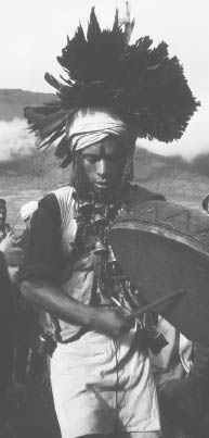
Shamans enter into a trance and the afflicted spirit speaks about what must be done to get well. (Photo by Stephen Bezruchka)
The trail departs from Hattibang from above the school at the south end of town. Take the wide path to the right/southwest and ascend for a few minutes, then descend to cross a stream (4757 feet, 1450 m) just below. Follow the stream for 20 minutes, crossing it several times. Eventually, just downstream from where two feeder streams have joined, cross to the south or true right (TR) side. This trail to the left ascends over a boulder that will be slick if damp. The trail then follows the left/south-side feeder stream. Ascend through lush and damp subtropical vegetation, best dealt with in the morning before sunlight hits this gully.
Reach a ridge crest and rest area named Pangsirang (5558 feet, 1694 m) in another 25 minutes (less than 1 hour from Hattibang); head right from here. (A 10-minute climb in the other direction, to the left/east, reveals a viewpoint (5643 feet, 1720 m) with a broad outlook, including a panorama of the mountains to the north.) Just beyond the rest area is a trail signboard providing two options: traveling directly to Jyandala village or summiting Siraichuli Peak en route. Both options are described below. However, most people prefer to reach Siraichuli around sunrise or sunset for an eye-catching light show on the snowy Himalayan range.
From the signpost, to the right is the lesser-used path that goes directly to Siraichuli, the highest point in Chitwan. The path ascends steeply to reach the summit (6338 feet, 1932 m, N 27° 45.740’ E 084° 37.875’), in 30 minutes. There is a small temple on top as well as a 360° commanding vantage. To head on to the Chepang village of Jyandala from here, descend steeply to the south and in 30 minutes reach a trail junction. Continue straight to cross over the ridge to descend to Jyandala in 10 more minutes (40 minutes from the summit).
To bypass Siraichuli and head from the signpost at Pangsirang directly to Jyandala, a walk of 25 minutes, take the lower, left trail. Tread carefully, as the trail passes through sections with sheer drop-offs. In 20 minutes the trail forks. Stay right and contour to Jyandala (5361 feet, 1634 m). Home stay is available in this Chepang hamlet.
There are two routes to ShakTikhor, a large bazaar town with bus service. The more scenic route passes through prime bird-watching forest and visits the ruins of an old fort. The direct route is described as an alternative for people with less time or as part of a circuit from ShakTikhor to Jyandala.
To head directly to ShakTikhor from Jyandala, continue to the southwest and in 15 minutes reach a school at a pass (5459 feet, 1664 m). Enjoy another view of the mountains from here before heading down to the southwest along the west side of a ridge. ShakTikhor can be seen below in the valley floor. Reach Mandredhunga (4921 feet, 1500 m), a collection of boulders along the ridge, in 25 minutes (40 minutes from Jyandala) and continue steeply to the south along the ridgeline to a place known as Rajban (3773 feet, 1150 m) where there is a water tap, in 1 hour. Stay along the ridgeline to the south, avoid trails heading down away from the ridge, and at one point the upper part of Sinti waterfall can be seen below to the east. (See side trip description below.) In 35 minutes reach a crest (3002 feet, 915 m), 1 hour 35 minutes from Mandredhunga, from where the trail drops down to the right/west of the ridgeline. Descend along a spur through Deorali (2451 feet, 747 m) to TumaTi (1165 feet, 355 m) and cross the ShakTi Khola to ShakTikhor in less than 1½ hours from the crest).
The Hindu castes are called by the general term PahAARi (people of the hills). They inhabit the middle hills and lower valleys, generally below 6000 ft (1800 m). Each caste has an ascribed profession, but many people no longer follow the rules and nowadays, it is not unusual for Nepalis to spend several years working abroad, particulary in the Middle East and Malaysia and sending remittances home. |
High Castes |
Today this group includes peasant farmers, civil servants, money lenders, and school teachers, as well as people following the traditional caste occupations. |
Bahun (Brahman)—the traditional priest caste. In former times, the Brahmans did not handle plows or eat certain prohibited foods (e.g., garlic, onions, tomatoes, certain kinds of meat) or consume liquor. These days, however, many of these prohibitions are ignored, even the rules against meat and alcohol. Some of these rules are still followed in the more remote and traditional rural areas. Brahmans can be grouped into those from the east (Purbiya) and those from the west (Kumaon). Offspring of irregular unions among Brahmans are termed Jaishi Bahun. |
Chhetri—the traditional warrior caste. It includes much the same occupations as the Brahmans, as well as soldiers in the Gurkha armies. The erstwhile royal family was Thakuri, a subcaste of Chhetri. The term Matwali Chhetri (“those who drink liquor”) refers to western peoples who are not given the sacred thread characteristic of the “twice born” castes of Brahman and Chhetri. |
Menial Castes |
Many men and women of the three lower menial castes no longer pursue blacksmithing, shoemaking, or tailoring but work as day laborers on the land of others or as porters for large trekking parties or merchant-traders. |
Damai or Darji—tailors and musicians for Hindu weddings and festivals |
Kaami—ironworkers, toolmakers, and sometimes silversmiths and goldsmiths (Sunar) |
Saarki—cobblers and leatherworkers |
| (These are the main castes found in the Nepali hills. Many other caste groups are found among the Newar, and in the Tarai regions.) |
If heading from Jyandala to ShakTikhor by way of Siraichuli peak, ChisopaniTar, and Upardangadhi, ascend the hill behind the upper part of the village to the northwest and reach a trail junction at a notch (5725 feet, 1745 m) in 15 minutes. To the right it is a steep 30-minute ascent to Siraichuli, 45 minutes from Jyandala.
Head left from the junction for ChisopaniTar and Upardangadhi. From Jyandala to Upardangadhi, the trail passes through an isolated area with dense vegetation and no facilities. The trail can be slippery and water is scarce. Proceed with caution. Descend from the junction through a ravine, avoiding any diversions from the widest path. From here to Upardangadhi you may hear a frequent chorus of cicadas hailing your passing. This area is also well known for bird-watching. In 20–25 minutes, cross a stream (5135 feet, 1565 m). The trail leads south from here.
In 5 more minutes, come to a ridge where the trail becomes faint. Head to the right/northwest and follow along the ridge. Take care with footing, as there are sections along a cliff face with precipitous drop-offs. After nearly 1 hour of following this ridge, reach a trail junction (5676 feet, 1730 m). Avoid the trail to the left/south from here, which descends steeply to ShakTikhor. Another trail to avoid makes a level contour to the right/north. Stay with the ridgeline heading northwest.
Insects are particularly abundant in the subtropical zone (3300–6500 feet/1000–2000 m in the west, to 5500 feet/1700 m in the east). Common butterflies include the plain and common tigers and blue and peacock pansies (all four also in tropical and temperate zones) and common Indian crow (also tropical zone). Large and especially colorful species occur, such as the golden birdwing (also tropical and temperate zones), Paris peacock, and glassy bluebottle (also temperate zone). The orange oakleaf, as its name implies, closely resembles an oak leaf when its wings are closed; it is also found in tropical and temperate zones. There is a bewildering variety of other butterfly groups with evocative names such as sailors, sergeants, windmills, and Jezebels. |
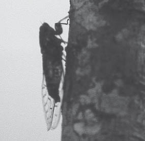 |
Cicada on a tree trunk (Photo by Stephen Bezruchka) |
Cicadas are large insects that resemble the color and pattern of the tree bark on which they live. Countless numbers make a prolonged, monotonous trilling in the forest. The noise is often so loud that it has a deafening effect. Males sing by vibrating a membrane on each side of the abdomen to attract females, which are incapable of making sounds. A local saying is that “cicada has a pleasant life for it has a silent wife.” There are at least four distinct sounds. One is a low-frequency rattle made in the night by the shechshelli, another the continuous pitch made during the day by the jyaaUkiri, another sounds almost electronic, and a fourth that is wavering and intermittent. Cicadas also occur in tropical and temperate zones. |
Fireflies, called junkiri (Lampyridae), are tiny beetles. Wingless females resemble larvae and are also called glow worms. At night, winged males flash lights on and off in flight during their courtship display. Lighting is produced by special glands in the abdomen. Each species has a distinctive glow. They also occur in tropical and temperate zones. |
Stick insects (Phasmida) have slender bodies up to 8 inches (20 cm) long, usually green or brown. They resemble twigs or branches amazingly well and stay motionless at the first sign of danger. |
| Praying mantids (Dictyoptera) are so called because, when waiting for prey, they hold their forelegs folded in front, appearing as if in prayer. Any insect, lizard, or small bird that comes by is snapped at with lightning speed by the viselike grip of the forelegs. They also occur in the tropical and temperate zones. |
In 25 more minutes the trail diverges. Stay left and reach a resting point in less than 10 more minutes. Descend through subtropical forest to a small meadow area known as ChisopaniTar (5551 feet, 1692 m) in 20 minutes, or 2 hours 40–45 minutes from Jyandala. The trail onward heads from the southwest end of the meadow (near a dilapidated structure). Traverse through a section with steep drop-offs and avoid two trails to the right within minutes of each other in less than 10 minutes from ChisopaniTar.
The trail descends steeply near or along the ridge to a notch (3878 feet, 1182 m) in 1 hour from ChisopaniTar. Contour to the west and in a little over 5 minutes reach a junction. To the left/south is the route to ShakTikhor. Continue straight to ascend to the Gurung and Chepang village of Upardangadhi (4029 feet, 1228 m) in less than 10 minutes (1¼ hours from ChisopaniTar, or 4 hours from Jyandala). This village was the headquarters of the Chitwan District until 1962. Ruins of a fort lie less than 10 minutes away on top of the hill to the south of the village.
The fort was built in the early 1800s by a grandson of the first king of Nepal, Prithvi Narayan Shah. The large complex (4160 feet, 1268 m) comprises 640 square meters and is surrounded by a moat and offers grand views of the surrounding area, particularly to the south, the Tarai.
To continue to ShakTikhor, follow the trail from Upardangadhi back down/east for 5 minutes to the juncture, then take the trail to the right/south. Descend, following a ridgeline, and reach a schoolhouse at the village of Kolar (3051 feet, 930 m) in 30 minutes. Continue along the ridgeline as you descend steeply to the tributary below, the ShakTi Khola (1624 feet, 495 m), in 45 minutes from Kolar.
You will have to wade aross the river several times before reaching Sampharang (1191 feet, 363 m) in 50 more minutes. In 10 minutes (2 hours 20 minutes from Upardangadhi), arrive at the bustling market town of ShakTikor (1070 feet, 326 m). There is a visitor center here next to the Chepang Museum and Chepang Development Center, which has locally produced goods on sale, including mustard seed oil and honey. The Chepang often refer to themselves as Praja or “subjects” (of the erstwhile kingdom, now of the republic).
A Hindu temple named Sri Muktinath Shivalaya is perched 50 yards (46 m) above and to the west of ShakTikhor’s main market. Near the town, a regiment of Maoist guerrillas were staged for several years in a cantonment by the U.N. while politicos worked out the details of a peace process. Two side excursions from ShakTikor are described below.
Jeeps and buses can be found along the main market road for transport to the town of TaDi, located 1–1½ hours away by vehicle on the major east–west highway of Nepal, the Mahendra Rajmarg. From TaDi, transport can be found to Sauraha, a popular entry point to the World Heritage Site (Natural) of Chitwan National Park, or west to Bharatpur’s modern bus station or the city of Narayanghat where transport to Pokhara and Kathmandu can be arranged.
Side Trip to Bat Cave and Sinti Waterfalls. For this half-day excursion from ShakTikhor to a cave and scenic waterfalls, cross the ShakTi Khola and head to the southeast on a flat, wide trail. In less than 20 minutes, reach houses of the Gurung village of Dogara (1076 feet, 328 m) and turn left/north here before crossing the Sinti Khola. Head up along the Sinti Khola for 45 minutes, crossing it several times. The cave is on the east (true left) side of the stream. There is an upper chamber, reached by a steep set of decrepit concrete stairs without railings. Use caution! A further 25-minute scramble upstream from the cave leads to twin waterfalls. Be prepared to get your feet wet, as the last 10 minutes of the journey is a scramble through the streambed.
Side Trip to Chitram Waterfall and Majhbang. A very few foreigners make this culturally rich 2-day side trip from ShakTikhor to Chitram Waterfall, with home stay at the Chepang village of Majhbang. However, if you wish to reach the waterfall beyond Majhbang village, the last 1½–1¾ hours is through dense subtropical forest with Himalayan giant nettle and other vegetation obscuring the trail. It is best to hire a local guide for this final section to the waterfall.
From ShakTikhor, cross the ShakTi Khola and head southeast on a flat, wide trail. In less than 20 minutes, reach houses of the village of Dogara (1076 feet, 328 m). Head straight/southeast to cross the Sinti Khola stream (no bridge) on a wide track. Within 10 minutes come to a fork; stay with the wide track to the right. Cross the Kayar Khola to its south (true left) side; wading is likely necessary, as there may not be a bridge. Reach DalanTar a few minutes beyond the river crossing.
Continue to Nibuwatar (1200 feet, 366 m) in less than 15 minutes and in another 30 minutes, reach Tindobhan (1427 feet, 435 m). Stay with the trail to the left which contours down to cross a tributary to its north side on a wooden bridge (1401 feet, 427 m) in 5 minutes, 1 hour 10 minutes from Dogara.
Climb steeply up the hill and then follow the ridgeline with occasional views to the northeast of Chitram Waterfall in the distance. Reach the first houses of the beguiling Chepang village of Majhbang (3133 feet, 955 m) in 1¼ hours from the bridge. Home stay is available here. Just beyond the first houses the trail diverges. Stay to the right to arrive at more homes within 10 minutes where there are small shops and additional home-stay houses as well as a Christian church.
Otherwise, to continue directly to Chitram Waterfall, proceed left from just beyond the first group of houses, then immediately right to contour along the ridgeline. There will be another glimpse of Chitram Waterfall along the way; avoid trails that head down away from the ridgeline. In 1 hour come to a junction at a notch (3510 feet, 1070 m) just after passing a Christian church (missionaries have been afoot among the Chepang). There is a water tap and small store near the pass, as well as a few houses of the Chepang village known as Cheurang, which encompasses a wide area. The waterfall that is visible off in the distance to the north of the notch is not Chitram Waterfall.
From this pass a guide would be useful. Descend to the left/northeast, and in less than 15 minutes the trail diverges. Follow the trail to the right to contour down to cross a tributary (3002 feet, 915 m), 25 minutes from the notch.
From here, the trail begins to pass through thick vegetation with Himalayan giant nettle and even the occasional leech. Tread carefully, as the trail is sometimes narrow and is often overgrown with vegetation and may be damp and slippery. Climb steeply to crest a ridge (4085 feet, 1245 m) before descending through thick vegetation. Reach the waterfall viewpoint (3609 feet, 1100 m, N 27° 42.997’ E 084° 40.912’) in another 1½–1¾ hours. This viewpoint is 150 yards/meters distant from the 260-foot (80-m) waterfall, and getting closer requires traversing steep terrain that is dense with vegetation. Behind the waterfall, up and over a ridge is a large cave that is best found with the assistance of a local guide.
The Gurung Heritage Trail (GHT) can be done on its own, as a 3–4-day trek, or combined with the Annapurna Circuit. If the latter, the trails meet up at Khudi, an initial stopover on the circuit after a bus ride to Besisahar. Be aware that the first and last low-elevation sections of this route may be excessively warm, depending on the season.
As a precursor to the Annapurna Circuit, the GHT’s scenic villages provide an inroad to the lifestyle and culture of Nepal’s mid-hills, particularly of the Gurung ethnic group. Additionally, beginning by this route can be a way of conditioning the legs, lungs, and rest of the body and mind for the higher reaches of the circuit. The village panoramas with a Himalaya backdrop offer unparalleled beauty, and the cultural interaction can be even more rewarding than the views. The Gurung villages are often compact with closely built homes, and much of the trail has been laid in stone, especially around the Gurung settlements—a herculean effort.
Although the GHT enters the Annapurna Conservation Area Project (ACAP) at Pasagaon village, this route is much less developed with tourist facilities as other areas of ACAP. Home-stay lodges are available along the way, and you will generally have the same home-cooked dishes as the locals. A portion of the proceeds from the food and lodging is supposed to go toward a local-level fund for conservation and community development, and most villages have an Aamaa Samuha (or Mother’s Group) dedicated to village-level development. Some of the villages are hydro-powered with electricity so electronic equipment and batteries can be charged, while most of the villages have only a solar power setup that is usually unsuitable for recharging electronic equipment.
Gurung comprise roughly 2.4 percent of the total population of Nepal. They have their own distinct language, which is closely related to Tamang and Thakali languages and is of the Tibeto-Burman family. Traditionally, the Gurung engaged in agriculture and animal husbandry, and many now serve outside the country as Gurkha soldiers.
Buses to Thumsikot/Gumle Bazaar are found in Pokhara at Rani Powa in the Mahendra Pul area. There are up to four buses per day. The first departs at 7AM and the last at 3:45 PM. The 2-hour journey offers occasional views along the way of Begnas Tal far below. The bus stops at Gumle Bazaar.
To proceed from Gumle Bazaar, cross the Madi River on a suspension bridge (1988 feet, 606 m) and turn right, then again bear right a minute beyond and contour through Thumsikot village (2018 feet, 615 m), passing Shivalaya Temple along the way. Reach a suspension bridge (1952 feet, 595 m) over the Wardi Khola in 15 minutes and cross to the east bank. There is a market area here at the confluence of the Wardi Khola and the Madi River. Jeeps are available from here to Gahate (a ride of less than 30 minutes) and beyond to Mijure (both villages are on the GHT). Otherwise, to travel by foot, follow the road upstream along the north bank of the Madi River and then ascend away from the river. Occasionally, the footpath will make a shortcut of the road.
In about 1 hour, the trail reaches a sharp bend in the road and departs to the left to a stone laid path and chautaaraa (rest area) just beyond. Reach another chautaaraa a minute farther; just after this second rest area, at a bend in the trail, a path heads left away from the stone path. Contour up through fields for 10–15 minutes to meet the road at a ridgeline near a school and shop. Stay to the right of the road to reach the predominantly Gurung hamlet of Gahate (3566 feet, 1087 m) in a few more minutes, 1½–1¾ hours from Gumle Bazaar. There is a large, pleasant pipal tree at a chautaaraa in this village providing a shady place to take a break.
As you leave the settlement, ascend past the small Mahadev Temple (Mahadev is one of Shiva’s many names) and stay to the left just beyond, rather than take the stone steps to the right. Along the way you begin to see Machhapuchhare peeking over the western ridgeline and part of the Annapurna and Lamjung ranges to the north. Farther east is the Manaslu range, which will come into view as you reach a tea shop (4334 feet, 1321 m) of the small village of Mijire, 40 minutes from Gahate.
Pass by a village development office and just below a health post, and contour to the right for 5 minutes, avoiding trails that descend, to reach the first house of the scattered village of Pakrikot (4232 feet, 1290 m). It takes 20 to 30 minutes to walk through Pakrikot, which is situated along a ridgeline. Midway, on a hillock, is a rarely manned gomba surrounded by barbed wire, with a water tank nearby, along with a small Hindu temple.
The houses of Pakrikot and Nagidhar blend together, and home stay is available in both as well as solar power. Descend from Pakrikot along a ridge toward a notch and fork right at a chorten (left heads to a school) to reach the shops of Nagidhar (4134 feet, 1260 m) in less than 10 minutes, 35–45 minutes from Mijire. A nursery school built with foreign aid lies above Nagidhar.
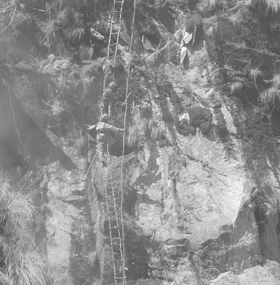
Honeyhunters use twine ladders to reach plump honeycombs that have been disarmed by smoke. (Photo by Alonzo Lyons)
Head north out of the village and begin a wide arcing contour around the valley. Reach a chautaaraa under a tree near a defunct water tap in less than 10 minutes. Descend (rather than take the trail to the left) and in less than 2 minutes the trail divides again. Take the trail to the right and reach another chautaaraa (3953 feet, 1205 m) in 10 more minutes. Just beyond the path splits again. This time, stay to the left and eventually pass near a small waterfall and then below a primary school to reach another resting point (4003 feet, 1220 m) in 40–45 minutes. Descend along the ridgeline and pass a small temple (3937 feet, 1200 m) located in the spread-out village of Rabi Danda. Proceeding from here can be unclear as there are many trails. The goal is to descend to the left into the Rudi Khola valley to the river below. Aim for the spur seen from the ridgeline where there are stone steps. The Rudi Khola is reached after a steep descent of 40 minutes.
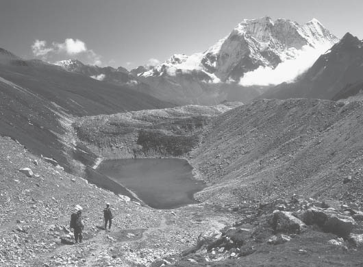
A moraine lake near Manang (Photo by Pat Morrow)
Contour upriver for 20 minutes to a suspension bridge (2625 feet, 800 m). Cross to the east bank of the Rudi Khola, then head left and pass a shop and houses. In a few minutes, come to a bridge to cross the Balaj Khola to the north bank. Just above are a few houses and a tea shop (2723 feet, 830 m), 2 hours 10 minutes from Nagidhar. From here, it is a relentless 2¼–2½-hour climb along a ridgeline to Pasagaon (5420 feet, 1652 m).
Enter through a traditional kani (gateway) which surmounts the trail. There is a gomba in Pasagaon. A health post and nearby chorten lie on a knob overlooking the village. Home stay is available, and most homes are solar powered.
Pass through another kani to two schools that are above town. At the far end of the high school field, the route follows a prominent stone path. Reach a chautaaraa in 25 minutes and bear left (rather than turning sharply to a stone path to the right). Ascend to another chautaaraa (6316 feet, 1925 m). Cross an open area where the trail becomes faint to then ascend steeply through isolated forest on stone steps to a ridge crest (6890 feet, 2100 m) in 1¼ hours from Pasagaon. Descend into the Midim Khola valley, at first through thick, uninhabited forest and then steeply down to a wooden bridge (4298 feet, 1310 m) over a feeder stream in 1½ hours from the ridge crest. Cross the bridge with a view to the left of a long water cascade. Work your way across the valley, skirting below fields, to reach a power plant (80 kw generating capacity) on the other side in 20 minutes. Bhujung village is supplied from this station.
Cross over a deep, narrow gorge of the Midim Khola on a suspension bridge (4354 feet, 1327 m) and ascend the long, steep staircase to Bhujung (5331 feet, 1625 m) in 45 minutes–1 hour from the power plant. Bhujung is one of the largest Gurung settlements in Nepal. Home stay is available as well as electricity to recharge batteries. There is a large Annapurna Conservation Project Area (ACAP) office located here as well.
Between Bhujung and Nayan there are no facilities and much of the trail is through uninhabited area. From Bhujung, ascend steeply to a large gateway near a high school with a nearby student hostel and continue up stone steps to a chautaaraa in 45 minutes. From here, begin a long contour high above the valley. Cross several feeder streams before then ascending gradually. Stay with the widest trail while avoiding trails that divert to ascend or descend. Reach a fork near a gomba in a grove of utis (alder) trees in 1½ more hours.
The gomba is to the left of the trail along with stone steps to the majestically set village of Ghan Pokhara which lies over 325 feet (100 m) higher. To visit Ghan Pokhara, pass by the gomba and ascend steeply up the steps for 15 minutes. Ghan Pokhara (7093 feet, 2162 m) lies on top of a hill with dramatic views of the mountains and surrounding landscape.
The village of Nayan is just beyond the fork near the gomba, 2¼ hours from Bhujung. Continue ascending gently, passing a health post, and staying left at a fork just beyond to reach another trail junction near the Uttar Kanya Temple. To the left of the small temple compound the trail leads to a sports ground a few minutes away, with a nearby lookout point on the east side of Ghalegaon. To the right, the trail passes two chorten and shortly thereafter forks left and ascends to the village of Ghalegaon (6863 feet, 2092 m), 15–20 minutes from Nayan. Ghalegaon is a large village that locals say is the origin site of the Gurung people. It has a magnificent setting, and home stay is possible here.
From Galaegaon to Khudi there are few facilities, and the first stretch is through uninhabited forest. Exit to the east and follow the stone laid path to the right to a chorten just beyond. Take the trail to the left from the chorten and reach another junction in a few minutes, and again stay left (the right branch descends to Baglung Pani and Besisahar). Round a ridge and then descend to a bend in the road (6496 feet, 1980 m) in 10–15 minutes.
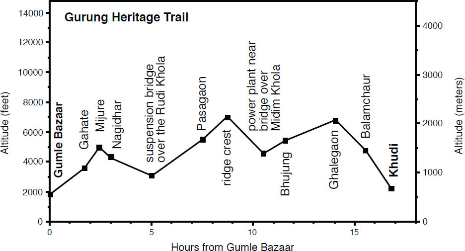
Continuing on from here, the route may be unclear. Cross the road at the bend and rather than dropping to the left to a chautaaraa, contour more evenly to the east through mixed vegetation. Eventually, descend to a chautaaraa in 20 minutes from the road. Head to the left/east rather than descend to the right/south, and pass a small temple housing several rock lingam in 5 minutes. Continue along a ridge, descending through mixed forest to another chautaaraa above the Gurung village of Mrijay in 45 minutes. Descend along the ridge and pass a chorten to reach a large chautaaraa in a few more minutes.
Continue straight/east rather than descending to the right or left and reach Balamchaur (4396 feet, 1340 m), the last Gurung village of this trek, in less than 5 minutes, 1 hour 35 minutes from Ghalegaon. The inhabitants on the way to Khudi will now be predominantly Chettri and Bahun (Brahman). Pass Simpani (4167 feet, 1270 m), with a small shop and cluster of four temples; the highest temple, named Thanimai, is built around the base of a chilaune (Schima wallichii) tree. Chilaune means “itch” in Nepali, and if you rub sap of this tree on your skin, you will learn how it got its name. The other three temples are built to honor Ganesh, the lovers Radha and Krishna, and Mahadev (also known as Shiva).
From Simpani the trail crisscrosses the road several times on the way to Khudi. Pass through Balam (3661 feet, 1116 m) and then the hamlet of Mahatok (3051 feet, 930 m). At the lower end of Mahatok, head to the right/east to reach the small temple in honor of Mahadev near the road. Follow the road down shortly to then descend to the left along stone steps to emerge at the roadway near a hotel in Khudi above the old bridge over the Khudi Khola, 1¼ hours from Balamchaur.
The trail onward from Khudi is described in Chapter 6.
The Kathmandu Valley Cultural Trail is an attractive getaway option for people with time to spare in Kathmandu, perhaps before a flight home or if a regional or national strike brings vehicle transport to a standstill (keep abreast of Nepal’s planned strikes at www.nepalbandh.com); generally this trek is for those with a wish to escape Kathmandu if only for a short 3-day excursion. Beautiful mountain panoramas complement the relatively fresher air once you reach the Shivapuri ridge, to the northeast of the valley, and beyond. Lodging facilities are available along the route, with camping and home stay available, too.
The first section of this trail climbs steeply to cross over the ridge to the lodges of Chisaapaani. This follows the same route to Helambu described in Chapter 8. However, from Chisaapaani, the route diverges to contour fairly evenly to the popular viewpoint hill destination of Nagarkot, perched atop a ridge. You then continue on to the large town and resort area of Dhulikhel, where economy to first-class accommodation can be found and buses to Kathmandu are available, or you can continue hiking to the religiously important site of Namo Buddha and pass through the alluring Newar town of Panauti on the way out where buses can be found for a return to Kathmandu.
Portions of the route follow the motor road, whereas much of the trail is along little-used jeep track although motorcycles will be encountered and sometimes other vehicles. The Nepal Environment and Tourism Initiative Foundation (NETIF, www.netif-nepal.org), along with a Finnish INGO, have developed the route and have set up sign posts and covered rest areas along the way.
To begin, follow the route described in Chapter 8 for Helambu, Sundarijal to Tharepati, up to the hill settlement of Chisaapaani.
Meet the trail to Nagarkot at the south end of Chisaapaani (7110 feet, 2167 m). The Shivapuri National Park entry post is just beyond the junction of the trail from Sundarijal. You will need to show an entry ticket, valid for 7 days, or be issued a new ticket if you are coming from Langtang. Be aware that the park area between Chisaapaani and Jhule, some 3 hours away, is isolated and without facilities.
Travel south on the motor track, little used by jeeps but frequented by motorcycles. A minute up the road from the check post, pass a ceremony area on the right with a Shiva-lingam and an army post just beyond. The wide path continues on the northeast side of the ridge to reach a meadow. A little farther, 45 minutes from Chisaapaani, is the wetland area known as Daap (6811 feet, 2076 m), an ideal camping site.
Continue east along the wide track lined with dense vegetation including many fern and rhododendron. Reach a NETIF-built water tap and rest area (6699 feet, 2042 m) at a signed crossroads in less than 40 minutes. The path to the right is another way down to Sundarijal. Take the upper route to continue along the jeep track toward Nagarkot. Reach another rest shelter (7005 feet, 2135 m) within 40 more minutes. Pass through an area thick with vegetation to a signed junction (7172 feet, 2186 m) within another 40–45 minutes.
Descend to the east/left toward Nagarkot on a wide trail. A minute below is a gate to an army post. Take the single-track trail to the left to skirt around the post. Pass through a copse of pine trees at the lower end of the base where there is a lodge at the beginning of the village of Jhule (6857 feet, 2090 m) in 15 minutes, or 2¼ hours from Daap. Just below the lodge, near a house, fork left from the wide track to a single track to pass by more houses of Jhule and reach the road again and another lodge in 5 minutes (the lodges of Jhule will be quieter than the lodges of the bazaar area of Chauki Bhanjyang).
Descend along the road to the village of Chauki Bhanjyang (5984 feet, 1824 m) in 35 minutes where a road from a housing development meets the path. A minute beyond, reach the road which buses ply between Sindupalchowk (Melamchi Pul) and Kathmandu. There are two lodges here. Head to the right for Nagarkot. Follow the road and over the next stretch you might encounter vehicle traffic. Keep to the widest road as it descends gently to the southwest. Pass through the predominantly Brahman village of Kaule (no facilities) and below a monastery complex to reach the tea shops and restaurants of Jaharsingh Pauwaa (5866 feet, 1788 m) in 30 minutes. Head to the left/east and as you leave the settlement, stay with the wider road on the right rather than descend to the left. Follow this road, avoiding a road branching to the left along the way, and pass through the hamlet of Bhojeni (5807 feet, 1770 m), without facilities, and reach the market of Katike Bhanjyang (5676 feet, 1730 m) in 60–70 minutes from Jaharsingh Pauwaa.
A spiked collar protects this Tibetan mastiff from leopards. (Photo by Pat Morrow)
From Katike, head east from the bazaar and bear right to follow the road with trail shortcuts along the way. In less than 5 minutes, one trail that branches to the right of the road is a wide trail known locally as the “Jungle Walk” through the Kushum Community Forest. If you follow this wide trail, you will pass through vegetation dense with bamboo on the west side of the ridge to reach the market area of Nagarkot (6447 feet, 1965 m) just north of a secondary school in 45–55 minutes. (Otherwise, if you stay to the narrower shortcut trails and road, you will begin reaching the hotels of Nagarkot within 30 minutes and the bazaar area in a further 20 minutes.) The highest point of Nagarkot hill station is MahAAnkaali Temple (6463 feet, 1970 m), although some hotels have buildings that rise higher. Langtang Lirung is visible directly to the north, peeking over the Gosainkund range. To the west of Langtang are the Ganesh Himal peaks and to the right are Purba Cheche, Dorje Lhakpa, Sisa Pangma, Gauri Shankar, Numbur, and more. Bus service to Kathmandu is available from Nagarkot.
To continue on to Dhulikhel, follow the blacktop road from Nagarkot’s main bazaar to the southeast, heading toward a lookout tower on a hilltop to the south. Reach an army officer training base in 15 minutes, and bear to the left along the road. Take a wide double-track dirt path that heads left/east away from the tarmac in 5 minutes more (NETIF is planning to put a sign here indicating the way to Dhulikhel). Contour around the hillside and keep to the widest trail to pass below two lodges and reach a jeep road in 35–40 minutes. Head to the left and shortly beyond the road diverges. The road to the right ascends to a gomba. Instead, bear left and continue contouring. Just beyond is a lodge and water bottling plant (6430 feet, 1960 m). In a little over 5 minutes, arrive at a small tea shop of Rohini Bhanjyang (6463 feet, 1970 m), 60–70 minutes from Nagarkot. This is a junction where a trail ties in from above from an army camp and lookout tower while other trails descend.
Keep straight/east rather than descend to the left or right, and ascend, gently at first, staying with the widest path to reach a junction near a ridgeline in 25 minutes. Take the jeep road to the right and follow the ridgeline. In 15 more minutes, reach a NETIF-built rest area (6588 feet, 2008 m). The trail to Kaangure and on to Dhulikhel descends steeply here to the left/south away from the road. In 15 minutes reach a signed junction (6053 feet, 1845 m). Do not head right here but continue straight to descend along the ridgeline. Reach a motor road in another 10 minutes and take it to the right/south. A tea shop of the nearby village of Kaangure is just below. Continue along the road to descend to a saddle known as Kaasi Bhanjyang (5446 feet, 1660 m), 1 hour 10 minutes from Rohini Bhanjyang, and do not follow the road to the right to descend. Continue straight/south across the saddle and take the trail that branches to the left from the road to climb the hill before you.
Ascend through cultivated area and then contour on the east side of the ridge to the Tamang hamlet of Tanchok (5974 feet, 1821 m) in 40–45 minutes, with the small Pemaa Choling Gomba. A lama of the Nyingmapa sect lives in the village. There are no facilities here. Stay to the left/southeast and skirt a hilltop to the east side. Dhulikhel comes into view ahead and below to the south, although you still have to descend the hill you are on and then ascend the hill across the way (there is not a trail that contours around that hill) before descending again to Dhulikhel.
Descend through fields and reach a motor road (5627 feet, 1715 m) in less than 20 minutes at the top of the widely scattered and predominately Chhetri village of Opi. Bear left and follow the road down to another road (5134 feet, 1565 m) in 20 minutes with a few shops. Head to the right on this road for a minute before turning left below a sacred pipal tree (Ficus religiosa), away from the road. As you ascend the hill, the path becomes a very wide track. Follow this track to the crest and then along the ridgeline. At one point, you can divert to the right to ascend to a lookout tower 5 minutes above (5577 feet, 1700 m) on a hilltop. The tower offers 360° views including the Kathmandu valley to the west and mountain peaks to the north and east.
After 35 minutes, as you start to descend, follow a narrower road that branches to the left away from the wide track and descend through the Chettri village of Kaarki with no facilities. In a few minutes, reach another road and take it to the left. Descend to the paved Arniko Highway, the highway which runs between Kathmandu (right) and Kodari (left) on the border of the Tibet Autonomous Region in 15 minutes. Follow this highway to the left to reach Dhulikhel’s bus station within 10 minutes, 1¾ hours from Tanchok. Dhulikhel (5052 feet, 1540 m) is a large town with many facilities, including high-end resorts, and distant mountain views.
To travel to the hallowed site of Namo Buddha, follow the paved road toward the east end of Dhulikhel to a place known locally as the “picnic spot,” a grassy area where people come to relax. The road forks here. To the left is Gaikreshar Temple a short distance away. Instead, follow the bend to the right/south and leave the road to ascend through an entryway and climb the staircase that leads to Kaali Mandir (Kali Temple). Within 15 minutes reach a large statue of a seated Shakyamuni Buddha (5364 feet, 1635 m) overlooking Dhulikhel. Keep ascending to a pass (5518 feet, 1682 m) in 5 more minutes. From the pass, a trail ascends for a few minutes to the left to the hilltop temple of Kaali Mandir (5610 feet, 1710 m) with a nearby army post that guards a relay tower.
To continue on to Namo Buddha, do not fork right from the pass but follow the signs to continue straight. Immediately below the pass is a hotel, and just beyond meet a road and continue straight along it (rather than ascend it to the right). In another 325 feet (100 m), take the trail branching to the left with a sign for Namo Buddha. Pass through Kaabre village (no facilities) and fork left at a junction in 10 minutes. Descend to Kaabre Bhanjyang (4977 feet, 1517 m) in another 10 minutes, 40–45 minutes from Dhulikhel, where there are simple restaurants and tea shops.
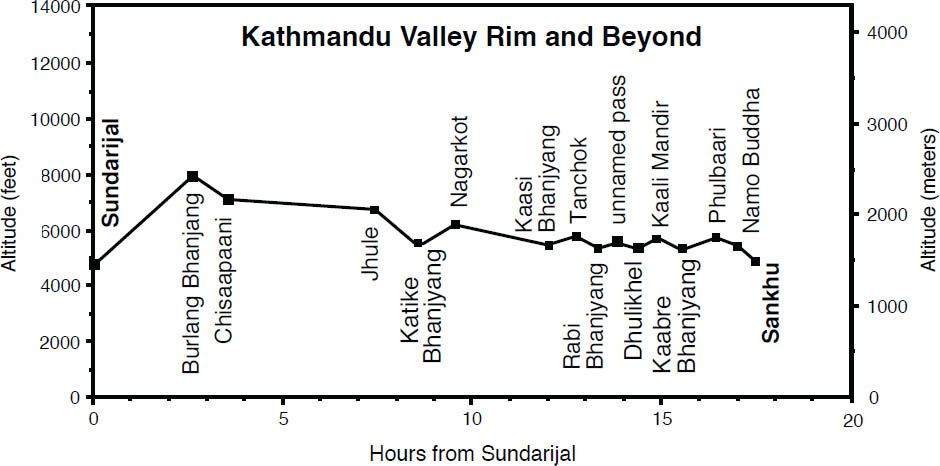 .
.
Abundant prayer flags ripple above Namo Buddha. (Photo by Alonzo Lyons).
Follow the road to the left and in a few minutes meet a paved road that carries traffic between Sindhuli District and Dhulikhel (and in the future will connect Kathmandu with eastern Nepal rather than the current roundabout route over the Thangkot escarpment). Cross the road and ascend along a dirt trail to the left and in a little more than 5 minutes, reach another dirt road. Rather than continuing straight up this road, cross it, bearing right, and keep to the right of the gated Nepal–Japan Friendship Tree Plantation to follow a wide dirt track. Continue climbing to the Chhetri village of FaskoT (5341 feet/1628 m) in 10 minutes. There are no facilities here.
Ascend to a stupa (5571 feet, 1698 m) at a notch in the ridgeline in just over 15 more minutes. Do not descend right or left here, but continue straight past the stupa and fork to the left 20 yards (18 m) beyond. In a few minutes reach another path and continue to the left and ascend to a ridge crest at Phulbaari village (5718 feet, 1743 m) with no facilities, in 15 minutes from the stupa, 50 minutes from Kaabre Bhanjyang. The monastery and prayer-flagged lined hilltop of Namo Buddha can be seen across the valley to the south. Continue up the ridge from Phulbaari and meet a road in 15 minutes. Take the road to the right for 20 yards (18) meters before branching to the left on a trail (the right branch is the gated compound of a large Buddhist retreat center).
In 5 minutes, reach a road and either follow this road to Namo Buddha or cross the road to contour above it through a grove of pine trees. Reach an area known as Chaapaa Bhanjyang with a few small shops and restaurants in 15 minutes. To the left a road winds up to a guesthouse near the monastery. To the right descend to several restaurants and shops and a few hotels of Namo Buddha near a stupa (5463 feet, 1665 m) in a few more minutes, 40 minutes from Phulbaari.
Legend has it that Shakyamuni Buddha, in a lifetime previous to becoming the Buddha, was a prince in the surrounding area. If you climb the hill to the south (5774 feet, 1760 m), in 10–15 minutes you will find a location where, as the story goes, this compassionate prince gave up his flesh (and life) to save a tigress incapacitated by hunger and too weak to hunt for herself and her cubs. There are several points of worship along the hilltop as well as a large monastery complex and a nearby hotel, all connected and enveloped by an immense array of colorful prayer flags fluttering over the scene.
Return to Dhulikhel the way you came, or by bus, or you might be able to take a jeep to Sankhu, a town below Namo Buddha where bus service can be had to Panauti and then on to Kathmandu. To hike to Sankhu, then descend the short staircase to the immediate north of the lower stupa and follow the road to the left. As you approach a chorten, within 5 minutes, take the trail that branches to the left away from the road. Descend to the village of Sankhu (4803 feet, 1464 m) in 15 more minutes. There are many mandarin orange trees around this village.
The bus stand is 10 minutes farther up the road. It takes less than 40 minutes by bus to reach the historic, Newar town of Panauti which has several captivating ancient temples and is well worth a visit. Buses to Kathmandu can be arranged from Panauti’s bus park, or you can travel from Panauti to the large town of Banepa, 30 minutes away by bus. Banepa lies on the Arniko Highway, where many buses to Kathmandu are available.
Before embarking on this trek, check with your embassy and local authorities that Dhorpatan, Rukum, and Rolpa districts are safe areas to visit. At the time of writing (May 2010) they were open and safe; however, the tentative peace process that ended the decade-long insurgency had not been completed after several years of negotiations and there had been threats of returning to arms. If the peace process fails, these areas should be avoided.
The trek follows a route that was used from west to east by a Maoist cadre during the 1996–2006 civil war to travel to Pokhara and on to Kathmandu from strongholds in Rukum and Rolpa districts where the rebellion was planned and launched. It can take up to two weeks and wends through areas that do not regularly see foreigners. Additionally, it involves a long, strenuous day between Thawang village and Jelbang village, with trail sections that have precipitous drop-offs. This journey is for the more ambitious, seasoned trekker with at least a sprinkling of language skills. It offers a chance for closer cultural interaction in a location that figures prominently in recent history. Accommodation might, at times, be challenging to arrange, especially after leaving Dhorpatan, a hunting reserve for bharal (blue sheep) and Himalayan tahr among other wildlife.
The Maoists’ route came to light when it was used for an attack on Beni, the headquarters of Myagdi District, in 2004. After the battle, the army gave chase in helicopters as the Maoists retreated over ground. It is alleged that the Maoists then purposefully set fire to the forest to divert attention and to disguise their escape. Scars of this burn might still be seen along the way near GurjaaghaT.
MAOBAADI (MAOISTS) |
Communist groups in Nepal emerged from behind the scenes as part of the 1950–51 opposition that led to the downfall of the ruling Rana family of hereditary prime ministers and reinstatement of the king. In 1959, the communists won four seats in Nepal’s first general election before King Mahendra’s royal takeover dissolved the nascent parliament in 1960. At this point Sino-Soviet communists supported the king and his anti-democratic rule and did so until the mid-1960s while another communist group sided with the Nepali Congress party and pro-democracy forces and operated from India. |
Communist factions became more extreme in the 1970s, and in the 1980s went underground. There was strict political self-censorship in Nepal before the first jana andolan or democracy movement in April 1990 when clandestine political parties then surfaced. After the successful movement and transition to democracy, little happened to improve the lives of the poorest. In 1992 anthropologist Stephen Mikesell predicted a rural response to Nepal’s repression, akin to Peru’s Shining Path guerilla movement. |
Political parties who call themselves Maoist exist in Peru and other parts of the world. Immediately south of Nepal in India, there are vast political movements. Naxalite-Maoists and others work underground and control a large part of the country referred to as the ‘red corridor.’ Their relationship to Nepal’s Maoists is dubious. |
Many different parties in Nepal call themselves communist today and determining what they stand for is not easy. Although presumably sharing elemental ideology, they often behave as partisan adversaries, and even make trysts with non-communist groups before aligning with comrades from other parties. Internecine rivalries are wrought not only of jealousy but a history of broken promises and therefore legitimate distrust. |
Pushpa Kamal Dahal and Baburam Bhattarai joined the communists in the 1980s as young ideologues and led a breakaway group in the mid-1990s that was not recognized as a separate party by the judicial system and thus was barred from elections in 1994. Subsequently, this party rejected the electoral process and went underground in 1995 and spawned the Unified Communist Party of Nepal (Maoist). |
In western districts where the Maoists had a stronghold, they became violent toward landlords, government officials, and generally those who had participated in the elections. This violence was in part a reaction to a military operation against them in 1994–95. A “People’s War” was launched in February 1996 which began as attacks on three police posts in Rolpa District and a bank in Gorkha. Dahal and Bhattari led the Maoists through the subsequent decade-long civil war and upwards of 14,000 Nepalese died. |
The Maoists gained notoriety for human rights abuses, only to be outdone by the (formerly Royal) Nepal Army. At one point during the ten-year insurgency, Nepal led the world in disappeared persons (people who went missing while in custody, considered to be executed by captors). The Maoists gave women positions in battle and recruited minors for soldiers. To this day, particularly violent is the paramilitary youth wing of the party, the Young Communist League. |
A second jana andolan led to a peace process that began in 2006. Two years later the Maoists won elections to form a democratic republic to the dismay of their Indian counterparts who did not want to accept the electoral mandate. The victory didn’t last long with Prime Minister Dahal resigning over his lack of authority over the official army and the fate of the Maoist troops. At present (fall 2010) the infighting of a fractious coalition government has led to an impasse and drafting a new constitution has been delayed. |
| If nothing else, Maoists holding positions in government are considered to be among the least venal in Nepal’s bureaucratic regime and remain a hope for ending endemic corruption. Their official website is www.ucpnm.org |
Please be aware that after leaving Dhorpatan, the following itinerary is only approximate and times have not been precisely measured by the authors. Food and accommodation might be a challenge to arrange.
Begin the trek in Beni, a 3–4-hour bus ride west of Pokhara. Buses to Beni can be found at Pokhara’s Baglung Bus Station. Beni (2700 feet, 823 m) is the administrative center of Myagdi District and has many facilities. The route heads west up the Myagdi Khola before crossing the Jaljala to leave this major drainage system and enter that of the Bheri Khola. To avoid the first 14 miles (24 km) of hiking, there is vehicle service from Beni along a rough road that follows the Myagdi Khola to Darbang village. The vehicle journey can take 2 or more hours and is being extended farther to Dharapani. However, if you go by vehicle, you will miss a visit to a developed hot springs along the way.
To walk in from Beni and visit the hot springs along the way, then proceed west up the Myagdi Khola. Pass many small villages, including Chutreni, Ghorsang, and Baguwa, to the tea shops of Singhaa (2800 feet, 914 m), reached in 1¼ hours from Beni. In 30 minutes, reach the first houses of Taatopaani, and after crossing a tributary, pass above a hot springs bathing area. Like similar places in other parts of the world, people with arthritis and other complaints have moved here to soak and soothe. The main part of town with simple lodges (2920 feet, 890 m) is 10 minutes beyond. Below this part of town, by the river, are more hot springs. Follow along the road to pass through Simalchaur (3100 feet, 945 m) and continue heading up the valley, staying on the left bank and not crossing any bridges over the main river, to reach the bazaar of Babiachaur (3220 feet, 981 m) with a guest house with basic rooms in 1¼ hours. Upstream, pass through Ranamang, Shastradara, and Baloti to reach RataDhunga (meaning “red rock”) in 1 hour. Reach Dharkharka in another 35 minutes. A landslide rumbled down the south bank in September 1988, claiming the lives of over 100 people. The rock and debris washed across the river, taking out the trail on the north bank. Such major events are now considered more likely due to tectonic (mountain-building) forces than to deforestation. Nepalis are quick to rebuild the slides and reclaim farmland.
Reach the large bazaar of Darbang (3520 feet, 1073 m) in 40 minutes with simple lodging and a police post. If you came by jeep you will begin walking from here unless the road onward to Dharapani has been completed. Cross the Myagdi Khola to the west (right) bank. Go past the few more hotels in the village and head north to reach Phedi, at the foot of the climb to Dharapani, in 30 minutes. Cross the tributary Daanga Khola on a suspension bridge and pick up the trail that climbs the ridge. As you climb, on the right is subtropical forest and, on the drier left, chir pine. This results from the marked climatological changes on either side of the ridge. Reach the spectacularly situated village of Dharapani (5125 feet, 1562 m) in 1 hour. Most of the houses here are single story with slate roofs. Solar power is available as well as simple lodging. Dhaulagiri is the massive mountain to the north, and off to the west is Gurja Himal, with Dhaulagiri IV and V in between. Hope to get views (unfettered by clouds) here in the morning or evening. If views elude you, don’t despair; Stephen had been by several times in the mid-1970s, and it wasn’t until years later that he saw the mountains unshackled by cloud.
The trail now contours high above the river, as it heads northwest toward the watershed. The views along this stretch are some of the finest in Nepal. Reach the Bahun–Chhetri village of Takum (5500 feet, 1676 m), another idyllic setting, in 1 hour. Takum also has solar power; however, unlike Dharapani, most of the houses here are two-story. The predominant ethnic groups in this region are Magar, Chhetri, Kaami, Damai, and Bahun. Continue contouring through Sibang with simple lodging, and then climb up to a teashop at Maachhim. As you round a bend by a chautaaraa (6600 feet, 2112 m) and begin to head northwest up the tributary Dara Khola, you can look north up the Myagdi Khola valley, which drains the west side of Dhaulagiri. A trail leaves from here for a strenuous high trek that encircles the seventh-highest mountain in the world by crossing French Pass at the headwaters of this valley.
Continue on to sprawling Phaleagaon (6200 feet, 1890 m) in 1½ hours. As you head up, notice that you are at the altitude limit of rice cultivation. However, nearer to Jumla, it will be growing almost 2000 feet (610 m) higher! Muna (6460 feet, 1969 m) is 45 minutes beyond. Across the valley is the spectacularly perched village of Dara. Reach the suspension bridge (6200 feet, 1990 m) over the Dara Khola and cross it to the left bank. Climb up to enter a side valley and cross the tributary and climb to the basic lodges and houses of Lumsum (7180 feet, 2188 m) within 1½ hours. Hydroelectricity is available in the evenings. Ask whether the next village is occupied and whether food is available, if you need to. Cross the Dara Khola again in 20 minutes, to the right bank, and head upstream to cross another tributary and begin to climb to Moreni (lowest at 7820 feet, 2383 m). The houses, scattered 700 feet (213 m) up the hillside, are reached in some 40 minutes, and they may be unoccupied in the middle of winter as the people descend to Lumsum. There may be little water along the way, so fill up at the valley bottom. Moreni is the last place to get food before Dhorpatan.
INSECTS OF THE TEMPERATE ZONE |
The temperate zone is rich in insects, although there is less variety than in the subtropical zone. Temperate-zone species include praying mantis, fireflies, cicadas, beetles, bugs, bees, ants, moths, and butterflies. |
| Butterflies are most common in open forests, forest clearings, and grassland. Common species include the common windmill (also found in the tropical zone), indian fritillary (also in the tropical zone), painted lady, indian red admiral, and indian tortoiseshell (the last three species common from the tropical to subalpine zones). The giant honeybee, or maahuri (Apis dorsata), is a large bee that forms highly sophisticated colonies. Common in the Himalaya, it makes a distinctively shaped hive—a single exposed sheet of wax hanging down from beneath a rock overhang or ledge. |
The trail heads southwest, reaching prickly-leaved oak forests, then rhododendron and birch higher up. After 2½ hours, you reach a cluster of prayer flags and a chorten (11,200 feet, 3414 m). Continue to the west (don’t take the left fork), pass a small spring, and reach the broad, flat plateau of Jaljala (to be differentiated from Jaljala mentioned later in Rolpa District) a few minutes later at a chautaaraa. The panorama from here takes in Machhapuchhre all the way to Churen Himal. Sunsets are supreme. There are some goTh here with a seasonal tea shop among them, used in the monsoon by people from Muna as they pasture their animals on the lush grass.
From Jaljala, follow the trail on the left/south side of the plateau, and don’t descend into the river valley to the north. Descend some 15 minutes to reach a small saddle point (11,000 feet, 3353 m) that is the actual watershed between the Kali Gandaki and the Bheri–Karnali. Head for the valley V shape, through the pastures, and pass below a group of goTh to reach more in 30 minutes from the chautaaraa. Beyond, cross to the right bank of the Uttar Ganga, which you will follow to Dhorpatan, and continue downvalley. Don’t cross over the river 30 minutes beyond, but enjoy the rhododendron and juniper forests on the north side of the valley. Reach an open area with goTh in 1½ hours The seasonal dwellings of GurjaaghaT (9900 feet, 3017 m), the next cluster of goTh on this side of the valley, is 20 minutes beyond. The Maoists, retreating after an attack on Beni in 2004, are alleged to have purposefully set afire the forest here as a diversion tactic for the Nepal Army helicopters pursuing them. From GurjaaghaT, cross several tributaries of the Simudar Khola on wooden bridges. As a variant side trip, you could head up this tributary valley, cross a pass and get to Gurjaakhaani, and then head back to Muna.
In 30 minutes from GurjaaghaT, head upstream in another tributary valley to cross the Gur Gad to its right bank on a suspension bridge. Rejoin the main valley, and reach the beginning of the broad Dhorpatan valley. The way keeps to the drier north side and reaches the Tibetan village of Chentung (9660 feet, 2944 m) with lodging in another hour. The Bon-po gomba of this village, behind you on the hillside, follows the tradition that predated the introduction of Buddhism to Tibet. It has been much changed, so it is difficult to tell adherents apart. The best way is to see which direction they spin their prayer wheels and circumambulate mani walls.
Continue west and reach Nauthar, also called Chisopaani, in 35 minutes. Here Nepalis come up from the south in the summer to grow potatoes and pasture animals. This agropastoral style of life is followed by many Nepalis in these parts as they farm the lowlands in the winter, grow rice in the summer, and move up with their animals to the high country in the monsoon. Cross the next tributary and go on through another Tibetan settlement before descending in 25 minutes to Dhorpatan village (9416 feet, 2870 m) with lodging and the Dhorpatan Hunting Reserve (510 square miles, 1325 sq km) office, where permits will be checked or obtained. The staff monitors the trophy hunting for blue sheep (bharal) that is done north of here. Just beyond is the flat area called Giraaund, meaning “ground,” the local term for an airstrip. The airstrip is overgrown with vegetation; planes haven’t landed here for many years.
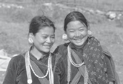 .
.
These Kham Magar girls near Dhorpatan wear banded cigarette wrappers in their ear lobes to make them look more Buddha-like. (Photo by Stephen Bezruchka)
Dhorpatan is the name of the grassland area, an unusually broad, flat valley (paaTan) in this rugged hill country. It was once a lake that was filled in. Many Nepalis from villages to the east, south, and west live here during the summer months, when they grow potatoes and pasture animals. Their settlements are seen along the perimeter of the valley, especially on its southern aspect, and at Nauthar. When Tibetan refugees were streaming over the hills during the Chinese takeover of 1959–60, many were directed to settle in this valley by leaflet maps dropped out of airplanes. Thus began one of the four original Tibetan refugee camps set up by the Swiss in the early 1960s. While many Tibetans moved to business centers and prospered, a few remained here, content in this remoter realm of Nepal. Stephen recalls the two years that he lived here in the 1970s as some of the best times of his life.
Although there are few views from the valley floor (Annapurna can be seen some 35 miles (56 km) to the east), easy climbs of the surrounding hills provide unparalleled views. You can travel a few days to the north into blue sheep country or up into the snows of the western Dhaulagiri range. The base camps of the various expeditions at the head of the Ghustung Khola are worth visiting. A route northwest leads to Dolpo, which is one of the most sparsely populated areas of Nepal. Food and shelter must be carried for all these trips to the north.
To the west and northwest live the Kham Magar, an ethnic group with strong animistic and shamanistic traditions. Food and shelter are difficult to obtain in this area and are best carried. A 4–5-day circuit through this region can be most interesting. After a long day down the Uttar Ganga, you reach the village of Takashera, where the flat-roofed houses are reminiscent of Thak Khola or of areas farther west. Cross the ridge up the tributary valley to the north and descend to Hukum (Hugaon), and go beyond to Maikot, on the north side of the Pelma Khola, in another very long day. The third day takes you through Puchhargaon and Yamakhar, where you meet the trail to Dolpo, which you can backtrack to Dhorpatan.
Those with less time should at least walk up one of the hills surrounding the valley for a view. The ridge crest directly south of the airstrip is the easiest viewpoint and takes less than 2 hours via one of its north-facing spurs. The view from here in clear weather extends beyond Langtang in the east! The hill to the north of the valley (13,600 feet, 4145 m) can be reached in 3–4 hours from the airstrip. Surtibang, the “writing desk” hill to the southwest, is an excellent viewpoint. Reach it by heading west for 30 minutes as the valley narrows to a bridge over the Uttar Ganga. Cross and ascend to the top (13,300 feet, 4054 m), in 4 hours from the former airstrip. Hiunchuli Patan is visible to the west. Finally, the highest of the peaks surrounding the valley, Phagune Dhuri (15,500 feet, 4724 m), lying to the northwest, can be reached from the Phagune Danda pass, on the route to Dolpo.
Other than continuing to Dolpo, which we do not describe, the return options from Dhorpatan are to retrace the same route out as followed in, or continue with the Guerilla Trek to the road at Sulichaur.
The following is a brief sketch of the itinerary to continue the Guerilla Trek, with route and walking times not reconnoitered by the authors themselves.
The trail from Dhorpatan heading north goes to Dolpo. Instead, head east on a trail that passes through Masa and Bhuju with apple orchards and pastureland through an area that is well known for bird-watching. Nisidhor (8776 feet, 2675 m), with basic lodging, lies next to a stream and is reached in 3–4 hours from Dhorpatan. Continue on through rhododendron forest and an area where leopards have been seen. Water may be scarce; fill up when and where you can. You cross from Baglung District into Rukum District, a district dominated by Maoists and used as a base during the war. Takashera (7119 feet, 2170 m) is a large Magar village near the banks of a tributary with basic lodging and telecommunication services, reached in 4½–6 hours from Nisidhor.
There are little to no water sources between Takashera and Lukum, the next village. Climb steeply to Lukum La (10171 feet, 3100 m) and descend, being careful, as there are steep drop-offs from the trail. Pass through Lukum village, a largely Magar community with closely built houses with flat earthen roofs. These interconnected houses generally feature a bare ground floor where livestock is sheltered, while the upper level contains the living quarters. Continue down to Rujhikhola village (7300 feet, 2225 m) in 4–5 hours from Takashera.
HEMP IN THE HIMALAYA |
| Hemp grows as a weed in a wide range of territory in Nepal. Although known as a source of intoxicants, and occasionally used this way by some people in Nepalese society, it serves other purposes as well. Seeds from the female plant are collected and pressed into oil in large hollowed-out wooden trays. The oil is commonly used for cooking out west, and it can also be used for making soap and as a liniment. Male plants growing in hot humid regions of the hills provide the best fiber. They are harvested toward the end of the monsoon; the stems are left to dry, then soaked, and the fibers pulled out with the teeth. They are then dried in the sun, beaten to soften them, and spun. Hemp is then woven into ropes and twine or made into a type of toga. |
The trek from Rujhikhola to Thawang involves another strenuous uphill climb through rhododendron forest with a steep downhill section. The route passes through small settlements and terraced fields to reach Thawang (6562 feet, 2000 m), a village nestled between two rivers and inhabited mainly by Kham Magar, 3½–4½ hours from Rujhikhola. Thawang was damaged during the war by mortar shells dropped from army helicopters. The hemp of the marijuana plants in the area is used for making rope, bags, and fine thread for weaving traditional clothing. Seeds are also used in making achaar, a pickled relish. A motor road is being built between Thawang and Holeri in the Tarai district of Dang to the south.
The next segment involves a strenuous ascent and descent with no facilities over a long day to reach the next settlement with little to no water except at the pass itself. Plan to depart early from Thawang. The path climbs uphill through rhododendron to a pass in a wetlands area known as Jaljala (10,367 feet, 3160 m) (to be differentiated from Jaljala pass, mentioned earlier en route to Dhorpatan from Beni) in Rolpa District in 4 hours. Rolpa District was also a Maoist rebel base during the insurgency. Maoist soldiers were previously given weapons training in this pristine forest and grasslands area abundant with flora and fauna. There are no facilities at Jaljala, although three small temples have been erected. Views can be had of the Dhaulagiri and Annapurna ranges and more, and nearby is Bhama Guphaa, a limestone cave. A further climb to the top of Dharampani (12,795 feet, 3900 m) offers impressive views in all directions, and locals say that even Api (23,400 feet, 7132 m) and Saipal (23,068 feet, 7031 m), the dominant peaks in the far west, can be made out.
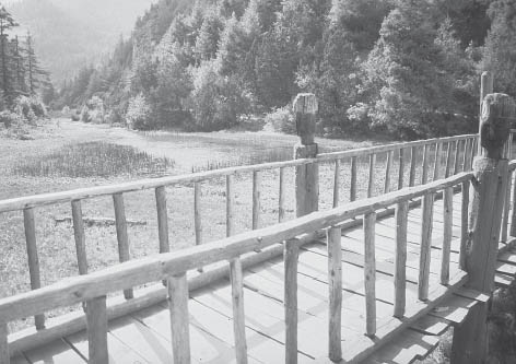 .
.
Protector deities on the bridge at RaRa Lake (Photo by Robin Biellik)
As you descend, be aware that some parts of the path have sheer drop-offs from the trail and water might be scarce en route to Jelbang village (5430 feet, 1655 m), some 4 hours or more away. A motor road is planned to Jelbang. Currently, the trek from Jelbang to the roadway at Sulichaur (2625 feet, 800 m) descends gently for 4–5 hours, passing beautiful villages and terraced fields. Sulichaur has a bustling bazaar and basic lodging, and buses to Kathmandu are available (13 or more hours).
The following routes will have settlements along part of the way with home stay, community lodges, and occasionally basic hotels. However, at some point, full self-sufficiency will be required in food and shelter for at least some sections of the journey. This self-reliance enables you to get beyond areas with facilities to remote areas that are more or less uninhabited. These isolated, infrequently visited areas allow closer communion with natural Nepal and a greater opportunity of encountering wildlife. An accompanying feeling of peace often results from being “away from it all,” strikingly close to the mountains or alongside mesmerizing alpine lakes.
At the southern edge of the Mugu District, at an altitude of almost 10,000 feet (3050 m), lies RaRa, the largest lake in Nepal. It has a circumference of almost 8 miles (13 km) and is nestled between heavily forested, steep-sided ridges that thrust up from the fault lines that riddle this section of the foot of the Himalaya. Few foreigners visit this area (only 146 were registered in 2009, 104 in 2008, and 82 in 2007).
Access to this region is from Pokhara to Beni by road and then trekking in via Dhorpatan and Lower Dolpo (2–3 weeks), or by air from an airstrip at Jumla (7660 feet, 2335 m), the headquarters of the Karnali Zone. The other nearest airfields are at Jufal near Dunai in Dolpo (5–6 days away), and KolTi in Bajura District (a 3-day trek). The flights usually pass through Surkhet or Nepalganj in the Tarai, and you might share the plane with large bags of rice from Nepal Food Corp and the U.N. Food Program, as Jumla District is regularly short on food.
A motor track now exists to Jumla from the Tarai, and thus vehicle transport is possible depending on the season and condition of the road. During the rainy season, it regularly washes out in several places and is hard going even under the best of circumstances. Generally, do not rely on this road access unless you have time to spare in the event of delays as well as a heroic ability to endure a long, arduous overland journey.
It is also possible to trek to Jumla from Surkhet to the south. This takes about a week and might offer viable alternatives for getting out of Jumla at the end of the trek. Finally, you can walk out to KolTi Airport in Bajura District in 3 days or even continue from there on to the roadway at Sanfebagar in Accham District with a possible detour through Khaptad National Park (mentioned at the end of this chapter under Additional Eco-Trekking Suggestions). The route from RaRa to KolTi has been improved by local labor through the U.N.’s food for work program, although scant facilities along the way provide the bare minimum in food and lodging.
Most people fly in to Jumla Airport (also called Khalanga Airport), and the usual route from Jumla to RaRa will be described. Be aware that air service is irregular and it can be difficult to arrange return flights, either in Kathmandu or in Jumla (Jufal and KolTi). Once you arrive in Jumla, see the airline representative immediately to confirm your return flight.
From the settlement of Jumla, it is a 3-day walk to RaRa Lake. There are two variations. Most people do well to take the longer route—at least if traveling without a guide who is familiar with the shorter lekh (hill) route. Then the return route described follows a trail to Sinja, an interesting, historic settlement. From here, a former trade and communication route links back to Jumla. Some food must be carried no matter which route you take.
Apples, rice, wheat, potatoes, or beans may sometimes be available in the bazaar in Jumla, but food shortages are a recurring problem in this whole area. As far as possible, supplies required for trekking should be brought from Kathmandu. A local guide is advised; porters can be hired locally too, but English-speaking ones are rare and prices are likely to be high. It is essential to carry a tent when trekking in this area. Many of the people along this trek are Thakuri, the erstwhile King’s caste, and have been known to be loath to allow anyone deemed below their status to enter or stay in their homes.
The town of Jumla lies alongside the Tila Khola. It was the site of an attack by the Maoists during the civil war, and heavy fighting occurred throughout the town. Looking north from the Jumla bazaar, you can see most of the trail to the top of DAAphe Lekh. The trail goes just to the left of the highest point of this lekh.
Head out of the main bazaar from Jumla (7660 feet, 2335 m) on a wide trail along the east (left) bank of the stream, heading north. Stay on this side more or less all the time until the climbing begins. The trail up this valley passes next to the buildings of a large technical school on the way to the pass. Run by the United Mission to Nepal, this school offers educational opportunities to people in this remote region. After 1 hour begin the ascent from the valley floor, climbing toward the right. The trail rises through a series of cultivated fields, passes close to a few scattered houses, and ascends steadily for over 1 hour. While still well below the main tree line, the trail rises steeply for about 15 minutes, crosses a small stream, and enters one of the few clusters of blue pine trees on the open stretch of hillside. Near this spot—above the trail and slightly off to the right—is a campsite with a freshwater spring (9000 feet, 2743 m), a good place to rest and cook a morning meal. This is the last water before the pass. Don’t go on in bad weather.
Ascending out of the trees, the trail opens out onto wide meadows rising gently to the north. About 15 minutes beyond the trees, the trail forks near some stone huts at Churiya Chaur (9875 feet, 3010 m). Take the less obvious right fork and, shortly after, reenter the forest. (The left fork is a more level main route to Sinja.) The trail emerges into high meadows, visible earlier from below, in 1½ hours from the fork. Another hour on increasingly difficult rocky terrain brings you to the pass, the DAAphe Lekh (12,100 feet, 3688 m). The summit is marked with a small chorten. There is a small peak to your left (13,715 feet, 4180 m) and another to your right (13,807 feet, 4224 m). From this point you should have a fine view back down over the Jumla valley to the 15,000-foot (4500-m) ridges to the south. There is no northern view until you cross the top of the pass.
This is the land of the ancient Malla Kingdom of the Karnali river basin. This region is literally littered with many of the cultural and historic artifacts of the Malla era, the twelfth to fourteenth centuries AD. At one time, the Malla Kingdom included portions of western Tibet as well. After its decline, the baaisi raja (twenty-two kingdoms) of west Nepal emerged and were not ceded to the expanding Gorkha kingdom until the nineteenth century. (Historians have postulated a relationship between the Malla kings of west Nepal and those of the Kathmandu valley just prior to the eighteenth-century Gorkha conquest, but there is no consensus.) |
Along the former “royal highway” of the Malla Kingdom of west Nepal, a walking route stretching north from the inner Tarai through Jumla and into Tibet, there are various inscribed stones that scholars have used to determine the nature and extent of the Malla domain. And there are ancient shrines to be seen throughout western Nepal dedicated to the prominent local deity called “Masta.” On some trails in the west, one may see carved wooden spirit effigies, festooned with bells, flowers, and strips of colored cloth, set out to appease the spirits that haunt each locale. Trekkers are admonished to respect local customs here and throughout Nepal, and to refrain from handling or taking souvenirs beyond what can be captured with a camera. Much of what is seen and admired here is sacred, and local feeling toward holy objects is not unlike the reverence and respect Westerners feel in the sanctuaries of the great cathedrals of Europe or in their hometown churches and synagogues. |
| One fascinating cultural feature of some of the more northerly dwelling Hindus of this region is their apparent “Tibetanization.” Unlike elsewhere in Nepal, some Chhetri and Thakuri of the west and far west are indistinguishable at first glance from their Buddhist BhoTiya neighbors. They wear the same style of clothing, construct similar flat-roofed houses, and pursue the same patterns of trade and subsistence economy. Their way of living is unlike that of their more “pure” Hindu caste neighbors to the south and east, who look down upon them in some respects. The BhoTiya cultural attributes noted here, and wherever they occur among non-BhoTiya people in Nepal, are reflections of the northern mountain environment. |
From the chorten, follow the trail across the top of the ridge, winding through patchy forest to the north before dropping again into open meadows. Note carefully the spot where you emerge from the trees. If you come back this way, it is very easy to miss the opening. If you climb straight on over these meadows, you reach a different pass that leads to the village of Padmara to the southeast and a longer walk back to Jumla.
Leave the meadows, cross a small stream, follow the trail into the trees, and descend rapidly through dense, mixed forest for 2 hours Notice the magnificent birch trees, the bark of which is collected for use as paper. And keep your eyes open for a DAAphe—the multicolored national bird of Nepal There may be bhaTTi for Nepali travelers along here.
Near the end of the descent, the trail drops very steeply to the Sinja Khola, which is immediately crossed by a bridge (8900 feet, 2713 m). Turning west, pass the bhaTTi of Naurighat along the north (right) bank of the river. Within the next hour, choose any suitable campsite along the valley floor by the river.
Approximately 1 hour from the Sinja Khola bridge, the trail rises from the riverbed to pass below the village of Bumra (9350 feet, 2850 m). An alternative campsite could be in the vicinity of the village. Supplies can sometimes be procured from locals.
From Bumra, continue along the side of the hill, proceeding about 500 feet (150 m) above the river. Pass just above another small village within 15 minutes. After another 15 minutes, descend steeply to cross a small stream entering the main river from the north. On the valley floor, cross the main stream (9250 feet, 2819 m), and immediately climb steeply again for 30 minutes to regain your former altitude. Within another hour, descend again to cross another stream entering from the north. At the foot of this descent, huddled beneath the steep rock walls on the far side of the stream, stand the few houses and small police post of Chauta (9000 feet, 2743 m). Splendid clay chilim (pipes) are made in this area and are sometimes sold at one of the shops and basic inns here. If you head downstream on the Sinja Khola, you will reach Sinja in less than a day. There is a route that returns to Chauta from RaRa Lake via Chabragaon. Hire a local guide if you wish to return this way and not do the long circuit via Sinja.
From Chauta, head north, following the trail gently uphill and crisscrossing the stream, the Chauta Khola, in a steep, narrow valley. Ascend to Bhulbule (10,270 feet, 3130 m), with a pair of simple lodges, and the RaRa Lake National Park entrance station, where you will have to pay an entrance fee if you didn’t in Kathmandu. A pleasant walk through groves of large walnut trees takes you to a small dharmsala (“resting place”) with a good, clear-flowing spring. Reach some isolated cultivated fields in 1 hour. In another 15 minutes, the trail passes out of the trees and, leaving the course of the stream, swings left onto the high, open pastures. You are now climbing again, to the pass of Ghurchi Lagna.
The wide trail proceeds almost directly westward, rising across a broad, grassy valley that runs almost at right angles to the final ridge. After you pass groups of large boulders for 30 minutes, the valley you are following splits into two distinct valleys. One heads northwest, and the other, containing the main trail, goes slightly northeast. The main trail heads up the right valley, climbing more or less north to the pass of the Ghurchi Lagna (11,300 feet, 3444 m), which is marked by a small stone chorten. The pass is some 3 hours from Chauta.
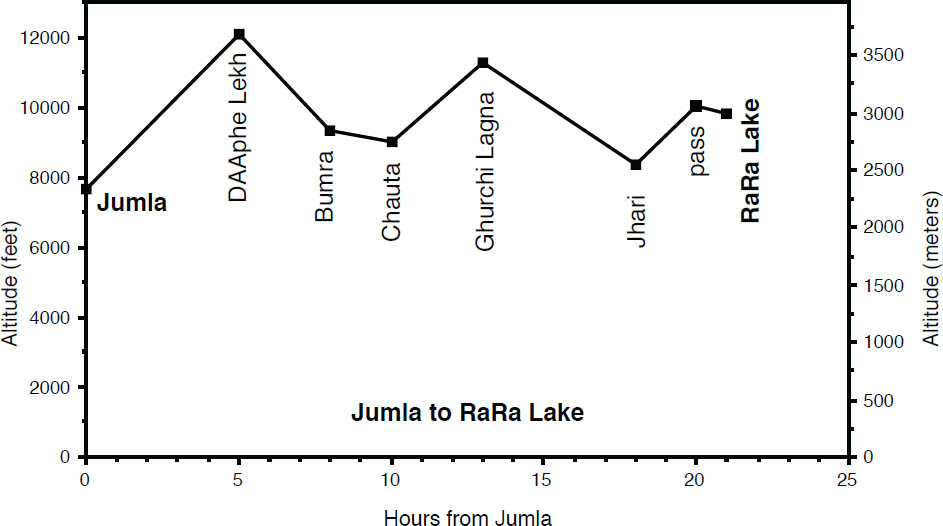 .
.
Descend 30 minutes, and take the trail branching to the left (to the right is the more circuitous route that passes through the village of Pina and on to Mugu District), and traverse, without losing much height, through young pine forest. Cross a couple of meadows, and then descend steeply to a clear stream and follow it to reach the small hamlet of Dhotu (7808 feet, 2380 m). Cross the stream and climb steeply to the north for 30 minutes to the village of Jhari (8350 feet, 2545 m) some 4–5 hours from the pass.
Continue up through the village and pass some huge cedars, climb again through the forest, and emerge after about 2 hours onto high, open pasture. Cross the easily gained summit (10,050 feet, 3063 m) and emerge at a flat area on the south side of RaRa Lake (9800 feet, 2987 m). Directly across, toward the northwestern side of the lake, is the building of the national park headquarters and staff and army accomodations. There is a simple lodge here.
The area surrounding the lake, which was designated a national park in 1975, offers spectacular scenery, although views of snow-capped peaks are limited. Magnificent examples of fir, pine, spruce, juniper, cedar, birch, and rhododendron are found in the forest. Wildlife, including bears, cats, wolves, and deer, has been observed in the area. Around the shores of the lake are some fine “Malla Stones”—pillars of rock bearing Devanagari inscriptions and figures of the sun and moon. The inscriptions probably date from the Malla kings, who reigned over much of the western Himalayan region in the twelfth century AD.
The best camping areas are on the lake’s south side, which has much more diverse topography and vegetation than the north side. Meadowlands blanketed with wildflowers, virgin spruce forest full of birds, and some streams on the southwest corner of the lake make for idyllic camping. Be aware that this area has a fragile ecosystem and cannot stand the excesses of contemporary trekking development.
Legend and folklore provide the bulk of knowledge about RaRa Lake. The locals believe it is at least 1800 feet (550 m) deep. They feel it is fed from underground springs flowing from the Mugu Karnali, which is located about 1800 feet (550 m) downhill from the lake on the other side of the north lekh. Given its size and location near one of the main trade routes to Tibet, it is surprising that the lake does not have greater historical or religious significance. Unlike many Himalayan lakes, it is not a pilgrimage site. An annual festival in July and August commemorates the intervention of the great god Thakur, who changed the direction of the outlet of the lake. Firing an arrow to the west, he opened the western hill to form the present outlet and, taking huge quantities of earth, he filled in the eastern outlet and stamped it firmly with his great feet. His footprints, embedded in a rock, are visible to this day at the eastern end of the lake. They are the festival’s main objects of interest—other than the attractive dancers and the local brew.
The lake’s inaccessible location has kept many of its secrets undiscovered. The potential for discovery may be one of the most exciting aspects of this trek. A 7–8-mile circumambulation of the serene lake takes a few hours.
You can return to Jumla by taking a less-traveled, longer route through Sinja, the historical summer capital of the Malla Kingdom (twelfth to fourteenth centuries AD). It is necessary to bring food, shelter, and a good map or a local guide familiar with the route.
From the RaRa Lake park headquarters (9900 feet, 3018 m), take the shore trail southwest to the lake outlet, the Khatyar Khola (9780 feet, 2981 m), also called the Nisha Khola, in 45 minutes. Do not cross the bridge here, but continue down the north (right) bank for 30 minutes and then cross the stream on a bridge. One trail continues west on the south (left) bank of the khola after ascending a 100-foot (30-m) knoll. Instead, take the left fork (heading south) up a small valley. Climb through the woods on a sometimes indefinite trail that keeps to the western side of the valley. Reach a meadow with a goTh (10,740 feet, 3274m) on a crest in 1 hour.
BRASSWORK |
Artisans from the Shakya clan of Kathmandu (their ancestors moved here eons ago) continue the centuries-old process of making the attractive small brass vessels Nepalis drink from and take to the fields. The process begins with a clay or metal mold that is covered by a thin layer of soft wax. This model is fitted by a lump of wax onto a hand-driven lathe, and the artist carves. The model is then encased in a clay-dung coating with outlets for the wax and inlets for the brass. It is heated in a charcoal oven, and then the outlets are opened to extract the wax. The mold is then fully baked. When ready, molten brass is poured into the mold. |
After cooling, the molds are broken open to remove the vessel, which is finished on the hand-driven lathe, which is rotated much faster. Complicated designs are made in separate parts, which are later joined together. The decorated patterns are made by a similar process, adding wax elements with the designs embossed into the wax mold. Later the artwork is completed with fine tools. Separate sections are then joined together. To obtain the intricate floral designs often seen, wax layers containing the carved designs are pasted on the plain wax forms created as above. The same clay coating is then carried out and final finishing done by hand. |
| A major center for this craft in the east is in Bhojpur District west of the Arun Khola. The brasscraft is sold by weight. The brass comes from Singapore or from recycled old objects (khu). Interestingly, the biggest consumers of this dying art are in the Kathmandu valley, where the urban people have a taste for this fine craftsmanship. Elsewhere in Nepal, cheaply produced stainless steel, aluminum, and plastic ware have become commonplace. |
Continue south, climbing steeply through oak, then birch, then rhododendron forests, to reach an alpine ridge (12,500 feet, 3810 m) in 2½ hours Above to the left is Chuchuemara Danda. Traverse on its west shoulder for 15 minutes and come out on a saddle above the Ghatte Khola. Descend 500 feet (150 m) to the headwaters of the river and continue down through the valley for 1 hour to GhorasAI (also known as Ghorasingha), site of the army guard post (10,500 feet, 3305 m), in 1½ hours from the saddle. Here the stream turns southwest. This is an appropriate and beautiful place to camp.
From GhorasAI, the trail at first heads down the right side of the valley and then soon crosses to the left, where it is flat, to the top of the moraine wall. It recrosses the stream here and descends steeply on the right-hand side. Botan can be seen ahead on the left-hand slopes of the valley. Regardless of trails heading off to the right in the general direction of Sinja, stay in this valley, taking the fork that keeps you closest to the Sinja/Hima Khola, until you reach it.
There is an excellent campsite at the confluence of the Jaljala and Sinja Kholas. Just below here, the Sinja Khola goes through a narrow gorge. The top end of Sinja village is at the lower end of this gorge, an additional 15-minute walk. Reach Sinja (8000 feet, 2438 m) in 4 hours from GhorasAI. A bridge across the Sinja/Hima Khola at this point (top end of the village and lower end of the gorge) is crossed to pick up the trail heading up the Jaljala Khola. Food and lodging might be difficult to find in Sinja, even for porters.
Sinja lies in a highly cultivated valley. To the south, on a prominent knoll, are the remains of the former capitol of this area. It is presently the site of a temple, Kankasundri. This area is well worth visiting by climbing the 400 feet (120 m) to the top of the knoll.
To return to Jumla, follow the historical route between Sinja and Khalanga, the old name for Jumla. The 2-day route through beautiful forests ascends a river valley to a lekh and descends to Jumla. A camp in the meadows along the way is ideal.
From Sinja, ascend the Jaljala Khola to the southeast, keeping to the south (left) bank on a good trail. Pass a few dwellings and goTh at Chala Chaur (9613 feet, 2930 m) and then the large pasture area of Jaljala Chaur (10,728 feet, 3270 m) to reach a high point (11,500 feet, 3505 m) in 5–6 hours. On the far watershed, the trail descends past a few houses through forests and pastures, and from Churiya Chaur follows south along the same route you originally took out from Jumla. Reach Jumla (7640 feet, 2329 m) in 3 hours from the high point.
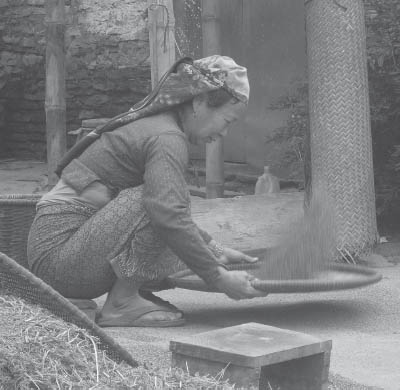 .
.
Winnowing rice is a routine task in many villages. (Photo by Alonzo Lyons)
Trekkers wishing an opportunity to visit wild cloud-forest jungle festooned with orchids, pass through Rai villages with their incredibly varied use of bamboo, or leave hill Nepal along the spine of a ridge to enter wild and sacred mountain terrain will be well rewarded in trekking to and in Makalu–Barun National Park. The park also has a surrounding conservation area where there are villages. The current park headquarters are in KhAADbari, with offices scattered throughout the region.
Makalu–Barun National Park (540 square miles, 1400 sq km) adjoins Sagarmatha National Park and lies to the east in the Arun valley watershed. It was visited by 1828 trekkers in 2009, 1371 trekkers in 2008, and only 261 in 2007. The route ascends the Arun Khola from Tumlingtar to reach the Makalu Base Camp in the upper Barun Khola valley. Ethnic groups encountered include the Tamang and Rai Hindu castes and Sherpa. Once you leave Tashigaon, the last inhabited place where food can be obtained, it takes about 5 days to reach the base camp, and fuel, food, shelter, and porters are necessary. The sense of leaving hill Nepal on the crest of a ridge from Tashigaon and crossing a high pass to enter a valley of sacred and majestic wild mountains is unparalleled in Nepal. This valley is clothed in dense forests hardly touched by people and is rich in wildlife. Two new bird species for Nepal have been found there, the slaty-bellied tesia and spotted wren-babbler.
Most people fly in to Tumlingtar’s airfield. Outside of the rainy season, vehicles are now able to reach Tumlingtar from Hille, the previous starting point for those arriving overland. Other trekkers find the way in or out to Tumlingtar via Solu–Khumbu. A possible exit is to follow the Arun Khola all the way south to leave hill Nepal behind and enter the Tarai, an excellent way out during the cool winter that passes the physically and spiritually powerful junction of the Tamur, Arun, and Sun Kosi rivers that drain all of eastern Nepal’s Himalaya.
Tumlingtar (1500 feet, 457 m) is a long plateau with a grass airstrip, hotels nearby to the east, and the main town just north. There is now a road and vehicle transport to KhAADbari. To hike there, head east to the right of the main road, passing chautaaraa along the way, to reach KhAADbari (3500 feet, 1067 m) in 2¾ hours. KhAADbari is a large Newar bazaar and Sankhuwasabha District’s administrative center, spread out along the ridge. The Makalu–Barun National Park office headquarters is here as well as a police check post, many shops, hotels, a hospital, and both a Wednesday and Saturday market.
Climb to the small Newar bazaar of Manebhanjyang (3700 feet, 1128 m), along the major ridge north–south. There are some simple hotels and tea shops for trekkers along the ridge. Heading toward Sedua, pass through small hamlets to reach the village of BhoTebas (5900 feet, 1798 m) below the ridge crest in 3½ hours from KhAADbari. There is simple lodging here. The trail continues close to the crest of a ridge (Chyankuti Bhanjyang), passing through Chichila with a tea shop in 2¼ hours. Look for the park signboard describing the mountain panorama. Continue in a glorious mixed broadleaf verdant forest, with moss everywhere. Don’t travel alone in this forest, as incidents have occurred to solo travelers. Reach MUDe (6500 feet, 1981 m) with basic lodging in another 3½ hours. Here you can see the route toward the Makalu Base Camp, while closer to hand, Nepalis maybe carrying a shrub, bound together on their backs. This is chiraito, a medicinal plant (jaDibuTi) sold at the road head.
Head north, mostly along the west side of the ridge, sometimes on a red mud (raato maaTo) trail that is treacherous in the monsoon. Continue on to reach Num TUDikhel (4920 feet, 1500 m), on the ridge with several shops and basic lodging in 3 hours. Leave the main north–south trail and descend steeply east through incredibly wet jungle on the east side of the valley where the sun rarely reaches to the suspension bridge over the Arun at 2260 feet (689 m) in 1½ hours. Downstream are some of the more difficult kayak and rafting ventures in Nepal. Cross the torrent to the true left side and climb up relentlessly, passing a tea shop along the way, to reach Sedua (also known as Murmidanda) (5000 feet, 1524 m) in 3 hours. Here there is a police post, a few shops with basic lodging and a school and park check point where you must present or obtain an entry permit.
It is good sense to hire porters who are familiar with the way to base camp; these could possibly be hired in Sedua or in Tashigaon. Make sure everyone is adequately clothed and equipped.
From Sedua, climb a ridge between the Ipsuwa (also called the Isuwa) Khola to the west and the Kasuwa Khola to the east, passing the hamlet of Manigaon, to a ridge crest with a shop and school at Cheksedanda (6100 feet, 1959 m). Then traverse less steeply the hillside striking northeast, entering Sherpa country, passing through Geng, above Hindrungma, and Ropessa to reach Tashigaon (6860 feet, 2090 m) in 3½ hours from Sedua. This is a cluster of Sherpa homes with prayer flags, and emergency radio might be available here. A variety of trails can lead here from Sedua, all converging at the water mill below the village.
Beyond Tashigaon (literally, “luck village”), there are no settlements but the area has lots of seasonal use in the monsoon. Many trekkers continuing onward from Tashigaon report that bad weather prevents them from seeing the mountains. Good luck! There are basic lodges in Tashigaon that cater to trekkers; while here you should ask whether there are any facilities open farther on toward the Makalu Base Camp. A kerosene depot has been established, and you should not burn wood beyond Tashigaon. You might be able to rent stoves and blankets here as well. Because there are no permanent villages beyond, you must be self-sufficient for the rest of the journey. There are seven signed campsites ahead designated by the park for use by trekkers. There are minimal or no toilet facilities developed there at present. While some lodges maybe in operation beyond, they are only temporary, pending new park regulations.
From Tashigaon head north, crossing a few streams, on a wide trail in a lush cloud forest, pass trees festooned with orchids, to reach a notch at 10,140 feet (3090 m). Enter the national park and descend in more open country on the west side of the ridge to Ongshisa (10,240 feet, 3121 m), with goTh frames. Water is a problem along here if there is no snow to melt. Continue out of the forest along a ridge crest, and look back to get a sense of climbing the backbone of hill Nepal to leave it behind. Reach Kongma Danda, a flat area for camping (11,420 feet, 3480 m), with water. There are overhangs that can be used as shelters to the east. It takes 4–4½ hours from Tashigaon. Be on the lookout for altitude illness, and return should there be anything other than mild symptoms when you could wait one night at Kongma Danda. Otherwise, if AMS strikes down in the Barun, you have to ascend to get out.
Continue along the ridge, past Gongru La, (13,156 feet, 4010 m) festooned with prayer flags, with views of Makalu, Chamlang, and Baruntse, as well as Kangchenjunga and Jannu to the east, to Sano Pokhari, “little lake” (12,533 feet, 3820 m), in 2 hours. Peaks 6 and 7 reflect in the waters. Climb to the first of two passes, the Tutula, at (14,238 feet, 4340 m), in 2¼ hours, and descend to Thulo Pokhari, the magical lake between the two passes. Climb again to the Kekela (13,724 feet, 4183 m), in 45 minutes from the other pass. Westerners call the first one Shipton Pass after the first westerner to cross them. It is so signed, but we prefer the Sherpa name. Make a mental map of the route you have taken, for if returning in a whiteout, locating the snow-covered route could be a nightmare. Don’t go on unless everyone is well equipped and not suffering from altitude illness.
Gaze off north into Tibet. Descend to the north, entering the fir, rhododendron, and birch forest of the Barun Khola valley, to reach Mambuk with spaces for camping (11,690 feet, 3563 m) in 2 hours from the pass. The descent can be treacherous if frozen. Reach the Barun Khola at 10,380 feet (3162 m), and head upstream on the true right, south bank to reach Jate (or lower Mambuk) as well as an overhang in 1 hour.
Plunge down to head up the valley in the Barun canyon, reaching Zhante before taking an hour to cross an active slide area. There is talk of rebuilding the trail to avoid this dangerous section. As the upper part of Makalu comes into view, pass Pematang, another flat area, to cross the Barun Khola and ascend to more open meadows among forests of silver fir and birch. Yangle Kharka (11,800 feet, 3597 m), in 3 hours from Jate, is another designated camping site with prayer flags and a small tea shop and gomba. Look south at the northeast side of Peak 6 and its ice-covered neighbors. Contour along on the south side of the Barun Khola, turning into an avalanche fan through scrub alders, to Neghe Kharka (12,160 feet, 3706 m), a serene, powerful pasture of frames and prayer flags, and another designated campsite, 30 minutes farther along. Guru Rimpoche stayed in a cave up high to the south and made a fist with his upturned thumb that is sculptured in one of the rocks. During the full moon of August in the monsoon, there is a festival held here, and people go up to the cave, where it is said that if you are infertile or barren and do a puja, you will bear children. Of the sheer cliffs to the south, the one on the right is the mother, on the left the father.
Shortly beyond, cross the Barun Khola to the true left on bridges between the huge boulders in the river (12,240 feet, 3730 m), then wind up behind in a quiet, peaceful valley, to come up to a clearing where to the south you can see two revered pregnant rock formations, Aama Phisum, that may account for the local fertility legends. Many waterfall slivers cascade off the canyon walls, if not frozen; one even emerges from a cave 325 feet (100 m) up. Reach the opening of Ripu Maidaan (13,040 feet, 3975 m), and then cross many tributaries to Tadosa (meaning “horse tie,” where Shiva tied his steed). Continue to Jark Kharka (13,850 feet, 4221 m), with its roofed hut, near the upper limit of forest 2 hours from Neghe Kharka. Be wary of altitude illness and quick to descend if necessary. Note how the valley above changes from a water worn V-shape below to a glacier scoured U-shape above.
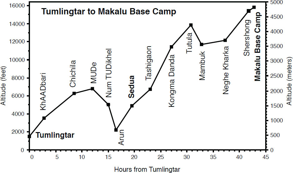
Typically children do not lack affection in the hills. (Photo by Stephen Bezruchka)
Continue past Langmale (Yak) Kharka where a basic lodge may be in operation and kerosene supplies might be replenished if available. Then crest a ridge from where you can see the lateral moraine of the Barun Glacier, pass Merek (a string of stone enclosures and a designated campsite where there are currently no lodges), and follow a stream to Shershong (15,450 feet, 4710 m) in 2½ hours, also a campsite near a stone built dwelling. This broad plane puts you on the Schneider Khumbu Himal map.
The valley turns north. Thrushes may flock around nearby. Supplicate beneath the immense south face of Makalu in the throne room of the gods. To appreciate the 2-mile-high face, hike to a flat, sandy shelf 1 hour up on the protected west side of a lateral moraine at 15,827 feet (4824 m). This area was the original site of the base camp for the 1955 French first ascent of Makalu (27,765 feet, 8463 m), an expedition where all members reached the summit! They headed northwest of here to cross a col to reach the north side of the mountain. Its name is taken from Maha-kala, meaning “the great black one,” clearly appropriate for this rocky massif.
Currently, expeditions head northwest up the Barun Glacier rubble to the so-called Hillary Base Camp, a tiring day’s hike up, where the views are minimal. Instead, climb up to the east, take a tent after you have acclimatized, and consider camping on the crest of the ridge (17,800 feet, 5425 m) to get the sunrise and sunset views if you can melt snow. The broad, white Kangshung (east) face of Everest can be seen, as well as Lhotse, and the flanks of their ridges reaching down into Tibet, unfamiliar views to most trekkers. Spectacular Chamlang looks very different from the peak you have been seeing. Many other hikes will suggest themselves to the energetic explorers.
The descent can be made remarkably quickly, but if you have good weather, take time to enjoy this special place.
The following treks are options to consider for those wishing to explore trails and territory away from the more established routes and regions. They offer an unrivaled opportunity to experience some of unseen Nepal. We have not precisely surveyed these areas ourselves and thus only a brief outline is given, leaving much to be explored and discovered. People who choose these routes should have prior experience trekking and should be self-reliant and confident on the trails.
The Numbur Cheese Circuit (NCC) is for the more ambitious trekker who is already acclimatized and is capable of full self-sufficiency away from lodging and human habitation. It is set in one of Nepal’s most newly protected areas, the Gauri–Shankar Conservation Area, which was formally declared at a cabinet meeting held at Kala Pattar in December 2009 ahead of Copenhagen climate talks. The route was jointly developed by the Ramechap Economic Development Forum and the U.N.’s International Labor Organization, and “launched” in October 2009 by the Nepal Tourism Board. As of yet, the NCC has seen few tourists and involves camping for much of the journey of up to two weeks or more.
The NCC trek is located in northern Ramechap District between the Rowaling and Everest regions, and follows the major drainage valleys of the Khimti and Likhu rivers, with the Gyajo La (16,010 feet, 4880 m) between them. Another high pass, Panch Pokhari (15,108 feet, 4605 m), is crossed en route with a nearby majestic collection of five small lakes. The name of this trek is derived from Numbur Peak (22831 feet, 6959 m), a yet unclimbed peak that dominates the route which takes you to its lap. Numbur (also known as Shorong Yul Lha) is believed to be the home of the protector deity of Solu, the area to the east.
Gauri–Shankar (23,459 feet, 7150 m) is also unclimbed, and permits are not issued for this sacred mountain. It is named after the God-couple Parvati, also known as Gauri, and Shiva, also known as Shankar. Gauri–Shankar was thought at one time to be the highest summit in the world because of its visibility from afar. This trek provides a unique and striking southeastern vantage of Gauri–Shankar rather than its usual broad expanse.
Two trekking peaks of Pharchamo (20,298 feet, 6187 m) and Ramdung (19,438 feet, 5925 m) are also in this area, and many more snowy peaks provide extraordinary views to complement the adjoining alpine landscape.
There are thirteen cheese factories along this route, most of them seasonal operations; however, the Swiss-designed plant at Thodung (10,140 feet, 3091 m) was established in 1957. Thodung Monastery is 30 minutes south of the cheese factory.
Along with the exceptional mountain vistas, this trek encompasses a variety of terrain from terraced fields to deep gorges and glacial lakes. There are a profusion of rhododendron blossoms in the springtime, and, given the area’s pristine remoteness, sightings of birds of prey, musk deer, and Himalayan tahr are not uncommon. Although possible, catching sight of a prowling snow leopard is extremely rare.
This route was primarily designed for eco-camping with some home stay. The swift altitude gain warrants considerable caution, and trekkers following this route must already be acclimatized from previous excursions and stay vigilant for symptoms of AMS (see Chapter 5).
The education of rural women and girls has advanced greatly over the last few decades. (Photo by Stephen Bezruchka)
Shivalaya has lodges and is reached in a daylong bus ride from the Old Bus Park (near Ratna Park) of Kathmandu. Or, consider disembarking at Jiri and walking from there, 3 hours away (see Chapter 7 for the route description between Jiri and Shivalaya).
This trek begins at Shivalaya (5873 feet, 1790 m) and follows the Khimti Khola north to reach Khahare village (7136 feet, 2175 m) where home stay is available. From Khahare onward be extremely vigilant of signs of AMS due to rapid elevation gains. Climb to Paanipakha (10,187 feet, 3105 m), where camping will be necessary. Continue ascending to Manedanda (12,927 feet, 3940 m), another campsite. Ascend to Panch Pokhari (14,813 feet, 4515 m), and more camping. The trail from Panch Pokhari to Tare (13,583 feet, 4140 m) travels over the Panch Pokhari Pass (15,108 feet, 4605 m). Camping will be necessary in Tare. Continue on from Tare via the Gyajo La (16,010 feet, 4880 m) to reach Ngeju Kharka (12,106 feet, 3690 m) and more camp sites.
The trail descends from Ngeju Kharka to Lhachhewar village (8743 feet, 2665 m) where you will have an opportunity for home stay. Descend from Lhachhewar to the village of Kyama (7808 feet, 2380 m), also with home stay. Continue on from Kyama to Gumdel (7398 feet, 2255 m), again with the option of home stay. Ascend from Gumdel to Serding (11,024 feet, 3360 m) where lodging is available. Continue on to Lapchane (10,187 feet, 3105 m) via Thodung (there is a cheese factory in Thodung), intersecting the overland route from Jiri to Everest along the way. Home stay is available in Lapchane. Descend from Lapchane to Those (5758 feet, 1755 m) where there are hotels and vehicle transport to Kathmandu (9 or more hours).
Both of these routes are in the southern, Solu area of Solu–Khumbu District and accessed from the main trail between Jiri and Lukla. Although near the popular Everest route, these treks are away from the beaten path and take you to previously unheralded areas. The routes offer entirely different experiences from each other.
The Pikey Peak Trek focuses on the culture of the mid-hills, the true gem of Nepal, passing through Tamang, Magar, Sherpa, Newar, and Rai areas with sensational village vistas draped in a mountain backdrop, and requires one night of self-sufficiency.
The Dudh Kunda (Milk Lake) Trek rises to a glacial lake at the base of the snowy giants, and requires four or more nights of full, self-sufficient camping. The lake lies at the lap of 22,831-foot (6959 m) Numbur Peak (also known as Shorong Yul Lha), believed to be the home of the protector deity of Solu, Khatang (22,484 feet, 6853 m), and Karyolung (21,362 feet, 6511 m). Pilgrims flock to the lake in August, and many believe that its waters can bless childless couples with fertility.
The routes tie in at Junbesi as well as Phaphlu/Salleri, and can be easily combined together (as well as with the Everest trek). Brief outlines of both are supplied below; however, neither has been reconnoitered by the authors.
Start either trek by flying into Phaphlu airport or arriving overland via Jiri to Junbesi village, as described in Chapter 7. (Another overland route is to Salleri via Okhaldhunga District to the south via jeep, a long ride over a rough road.)
Beginning in Junbesi (8775 feet, 2675 m), the route follows the Junbesi Khola for much of the way to reach Phaphlu village (8100 feet, 2469 m) where there is an airport. Continue to the town of Salleri (7841 feet, 2390 m), Solu–Khumbu District’s headquarters with many facilities. From Salleri the route leads to Dorphu and then on to Ghunsa (7710 feet, 2350 m). Continue on from Ghunsa to the Tamang village of Kerung (7874 feet, 2400 m) where there is a gombaa and then climb to Pattale (9318 feet, 2840 m). From Pattale continue to Sigane where there is a Hindu temple and then reach the Sherpa village of Jhapre (9252 feet, 2820 m) with a gombaa. The route onward from Jhapre passes through Bhulbule on the way to Pikey Base Camp (11,942 feet, 3640 m). There is a tea shop in Bhulbule; however, there are no facilities at the base camp. Ascend to Pikey Peak (13,159 feet, 4010 m) with arresting views of Kanchengjunga to the east, Everest Makalu and Numbur Peak to the north, and more, including a broad vantage of the beautiful Solu valley dotted with settlements. Descend to the main Jiri–Everest route between Goyem (10,350 feet, 3155 m) and Lamjura Pass (11,580 feet, 3530 m). From here you can walk out to bus service at Bhandar, Shivalaya, or Jiri (route described in reverse in Chapter 7).
WEAVING TRADITIONS: COTTON |
| Cotton originated in South Asia, and it has been grown in Nepal for at least several hundred years. Cheap imported cloth has stifled much local production. Imported yarn is spun into lively attractive patterns for producing dhaka cloth made into the traditional men’s hat or Topi. The Rai and Limbu of the eastern hills are the source of this tradition, and Terhathum, south of Basantapur, is a major production center. Weaving takes place in groups near homes, with children playing about. Men make the loom, and the women weave. Inlay and tapestry patterns are continually being created, and the interplay of colors produce desirable textiles, as well as caps. Much of this material has made its way to Kathmandu and is being used by fashion designers there and exported as well. |
This trek begins from Junbesi to head north to Thubten Chholing Gomba (9580 feet, 2920 m). Be extremely vigilant of AMS due to rapid elevation gains from here onward as you ascend to Sengge Phuk (12,927 feet, 3940 m). Sengge Phuk is a cave hermitage built into a rock overhang. Continue from Sengge Phuk to Bhasa Khola-Beni (12,894 feet, 3930 m) before a long ascent to Dudh Khunda lake (14,964 feet, 4561 m. Return from Dudh Khunda via Saharsabeni (12,582 feet, 3835 m) to Ringmo village (8924 feet, 2720 m) which lies on the Jiri–Everest route. Continue from Ringmo to Tragsindho (9711 feet, 2960 m) with hotels and a gombaa. Descend from Tragsindho to Nuntale (aka, Manidingma) (7365 feet, 2245 m) and continue on to Thulo Dhunga. From Thulo Dhunga the route reaches Sombare (aka Bhasa), a village of Khaling Rai which is a subgroup of the Rai ethnicity. Khaling Rai are well-known weavers who follow a tradition of ancestor worship and animist practices. There is a Khaling Rai museum in Bhasa. Travel on from Sombare/Bhasa to the Sherpa village of Changmanteng. A viewpoint atop nearby Rutnaki hill (11,483 feet, 3500 m) provides a panoramic feast. Continue to Ratnange and on to Phaphlu. Return flights are available from Phaphlu, or you could begin the Pikey Peak Trail (see above) or head directly to Junbesi and then out to Shivalya along the main route.
The Machhapuchhre Model Trek—also known as TAAN (Trekking Agents Association of Nepal) Model Trek—is one of Nepal’s most newly identified treks, located in an uncrowded area of the ACAP (Annapurna Conservation Area Project) region where few tourists have previously visited. This route was jointly developed by TAAN’s Pokhara Chapter, ACAP, and The Swiss National Centre of Competence in Research to provide access to a pristine area as an alternative to the well-established, more commercial trekking routes. Both it and the Sikles Eco-Trek offer an alternative to get away from the recent road building along the Annapurna Circuit while remaining in the ACAP area. There are several options for these treks, with home stay available along part of the way where you can experience the true gem of Nepal, the culture of the mid-hills. However, camping will be necessary to reach the upper heights of the Machhapuchhre Model Trek, and most visitors make arrangements for this through an agency. The following are brief, suggested itineraries, although several other route options are available.
The Macchapuchhre Model Trek takes you to the base of Mardi Himal (18,218 feet, 5553 m), a so-called trekking peak, and the unclimbed Machhapuchhre (22,956 feet, 6997 m) offering up-close, dramatic views of their south faces and vistas of the surrounding Himalayan giants and the Pokhara valley below. This area was once referred to as “The Other Sanctuary” by Colonel Jimmy Roberts, considered the father of trekking in Nepal. The swift altitude gain warrants considerable caution, and trekkers following this route must already be acclimatized from previous excursions and still need to be especially vigilant for signs of AMS (see Chapter 5).
There are many options in this area, including a start from Phedi, which is also an option for starting the Annapurna Sanctuary Trek. Phedi is reached by bus from Pokhara’s Baglung Bus Station. From Phedi (3750 feet, 1143 m), start trekking to pass Dhampus (5560 feet, 1695 m) and Potana (6460 feet, 1969 m) and reach the lodges of Bhichok Deorali (6922 feet, 2110 m). (Chapter 6 has details about the route from Phedi to Bhichok Deorali.)
To Mardi Himal Base Camp West. From here the route branches away from the Annapurna Sanctuary route and heads along the ridgeline to the northeast, following this skeleton itinerary: Bhichok Deorali to Forest Camp (8530 feet, 2600 m); Forest Camp to Low Camp (10,007 feet, 3050 m); Low Camp to High Camp (12,795 feet, 3900 m); High Camp to Mardi Himal Base Camp, West (14,764 feet, 4500 m). Fully self-sufficient camping is required, along with wariness of symptoms of AMS.
To Mardi Himal Base Camp South. Another option is to start the trek at the crossing of the Mardi Khola at Mardi Pul (3675 feet, 1120 m), north of Hemja Milanchok, a town along the road from Pokhara to Beni. Climb to the village of Ribhan (4692 feet, 1430 m), with home stay available; beyond this point, self-sufficient camping is required. Ascend to a viewpoint named Odane (8245 feet, 2513 m), and on to Khumai Danda (10,646 feet, 3245 m), Korchon (12,080 feet, 3682 m), and then Mardi Himal Base Camp, South (13,517 feet, 4120 m). Again, beware of the extreme altitude gains in a short period of time; trekkers should be previously acclimatized before attempting either of the above routes and must remain on the lookout for symptoms of AMS. Other options for home stay in the lower elevations of this area include the following villages: Lwang, Ghalel, Takru, Sidhing, as well as Armala, Ghachok, and Tuse Dhibrang, Misra, and Karuwa.
This trek takes you to mainly Gurung villages that are away from the beaten track and in the shadow of the Lamjung and Annapurna ranges, with superb village and mountain vistas. This route will be especially delightful in the springtime when the rhododendrons are in bloom.
Start the trek at the crossing of the Mardi Khola (3675 feet, 1120 m) at Mardi Pul, north of Hemja Milanchok, a town along the road from Pokhara to Beni. Follow the Seti Khola past the Gurung settlement of Ghachok to Dhiprang (with hot springs a further 20 minutes upstream at Kharpaani, aka Tatopaani). Cross the Seti Khola and pass through the settlement of Chaur before crossing the Sardi Khola and ascending to the Gurung settlement of Ghalegaon (5475 feet, 1669 m) near Ghalekharkaand, then climb to a pass at Jhakarphulan (8900 feet, 2713 m, no facilities) and on to Nyaulikharka (7290 feet, 2222 m) (no facilities). Continue on to the large Gurung settlements of Parche and Sikles (6496 feet, 1980 m), overlooking the Madi River, with fine views of Annapurna II, IV, and the Lamjung Range. Follow the Madi River south down to Sonda and then Chansu (3215 feet, 980 m). Continue on to Yangjakot to Bhaise and then climb to Kalikasthan (3642 feet, 1110 m) before descending to Begnas Tal (2690 feet, 820 m) and vehicle transport back to Pokhara.
Khaptad National Park (87 square miles, 225 sq km) is widely acclaimed for the beauty of its subalpine vegetation and grassland, and renowned as the serene hermitage site of the late Khaptad Baba (also known as Swami Sachchidananda Saraswati) who lived here in contemplation for half a century. Khaptad, set in the mid-hills of the far west and bordered by four districts, is remote, uninhabited, and difficult to reach. It receives a small number of foreign tourists per season (and less than 300 total since it officially opened in 1984). In 2009 only two foreigners visited, down from twenty-nine in 2008 and nine in 2007. There are only a few, spartan commercial lodges along the route, with most foreigners choosing to camp. However, several times a year a flood of local pilgrims from surrounding districts arrive for festival celebrations.
Alonzo was lucky enough to chance upon a leopard on his first visit to Khaptad in 1994. The area is an isolated massif reaching 10,584 feet (3226 m) at its highest point, Sahasralinga; it lies in far western Nepal south of the main Himalayan chain. From viewpoints in the park, the Kumoan range in India can be seen to the west, Api (23,398 feet, 7132 m) and Saipal (23,067 feet, 7031 m) to the north, and even Dhaulagiri and Annapurna to the east. Beautiful oak and rhododendron forests cover the slopes, and the rolling plateau on top consists of coniferous forests interspersed with grasslands. There is an interesting variety of bird species present, including the satyr tragopan pheasant and great parrotbill. As many as 270 species of birds are said to be found in Khaptad and over 10 percent of Nepal’s flowering plants. The meadows are covered in a mass of flowers in spring and summer. Khaptad is also renowned for its jaDibuTi (medicinal herbs).
There are several sites to visit within the park that are considered sacred, including Ashutosh Sahas, a natural lingam formation; Khaptad Daha, a marshy pond; Nag Dhunga (Snake Rock), a boulder with snakelike indentations and striations; Sita Paila, a stone that devotees claim has Hindu Goddess Sita’s foot imprint; Tribeni Temple complex, the meeting point of four districts (Accham, Bajhang, Bajura, and Doti); and the former swami’s living quarters and meditation area, as well as Bolde Judi, a lookout tower.
The suggested trek begins at Silgadhi, Doti District Headquarters. From Kathmandu’s Baleju Bus Station (also known as Gongabu or New Bus Park), take the bus to Dipayal (headquarters of the Far Western Zone Development Region) and on to Silgadhi (a 25-hour bus ride via Atariya, Kailali District). Silgadhi is about 1 hour by bus from Dipayal, a large bazaar town and the starting point for a trek into Khaptad National Park.
The following is a skeleton itinerary, and the area has not been precisely surveyed by the authors.
The trek begins in Silgadhi and leads up to Baglekh. From Baglekh continue to Jhingrana village. Jhingrana is a small hamlet with mud and stone houses. This is the Khaptad National Park entry point, with a 1000 NRS entry fee. Inquire here as to whether facilities at Beachpaani are currently open. The trail continues from Jhingrana to Beachpaani which has a seasonal tea shop and simple lodge. Continue on from Beachpaani to the park headquarters and a seasonal tea house with basic lodging as well as a government-run guest house and army post.
Return via the approach route in reverse, or travel to Accham District which lies to the west of the park. To reach Accham, head in the direction of Sahasralinga, the highest point of the park, pass Lauri Chadaune and Kalapokhara along the way to Chaukute village. Chaukute is a Chettri and Brahman village with small shops and lies on the bus route between Silgadhi and Sanphebagar. Home stay can possibly be arranged in Chaukute. From Chaukute continue to Sanphebagar, a large bazaar town in Accham District with an airport and bus service to Kathmandu. Bus service between Sanphebagar and Silgadhi takes four hours or more. Alternatively, from Kalopokhara, mentioned above, another route that bypasses the road heads west through Budakot and descends to Sanphebagar.
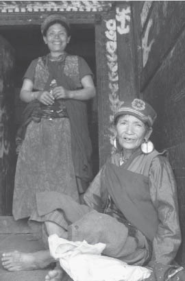
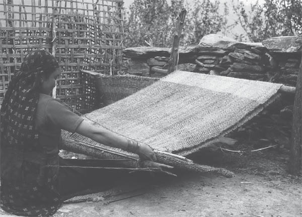
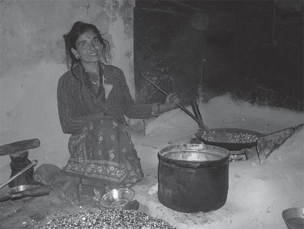
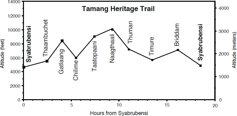
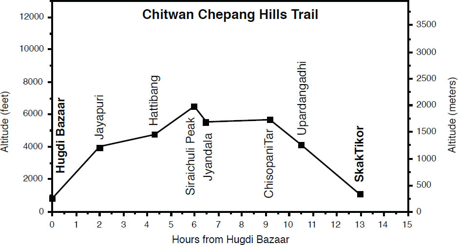
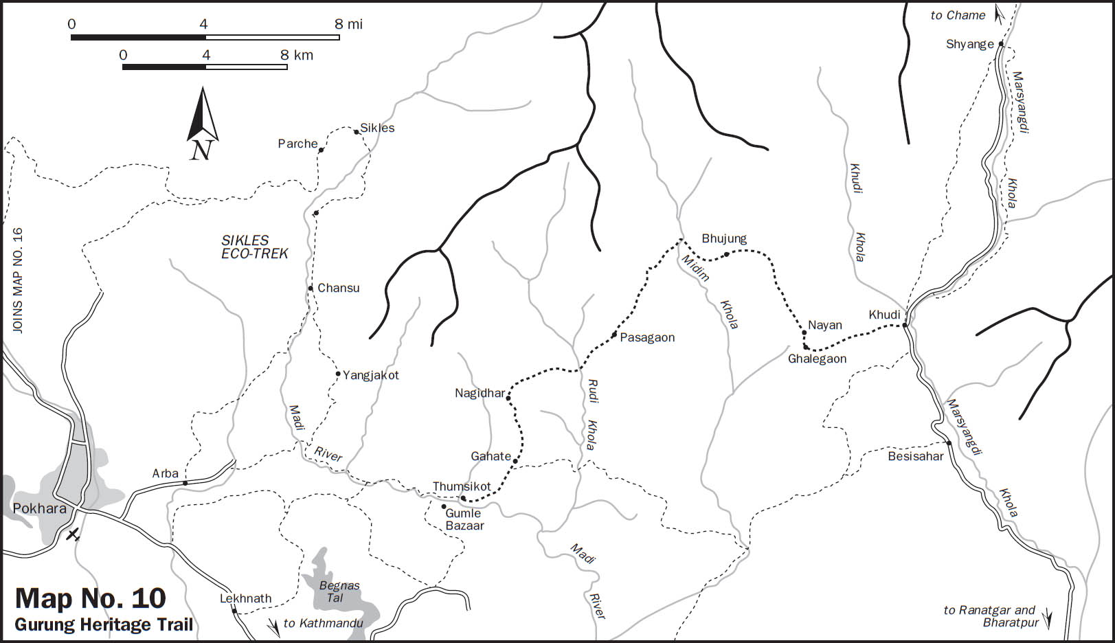
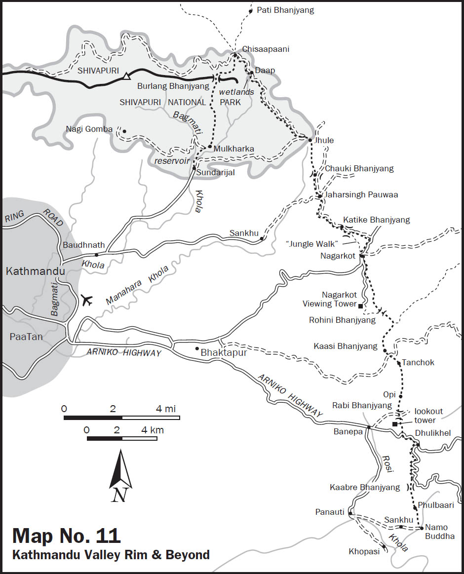
 .
.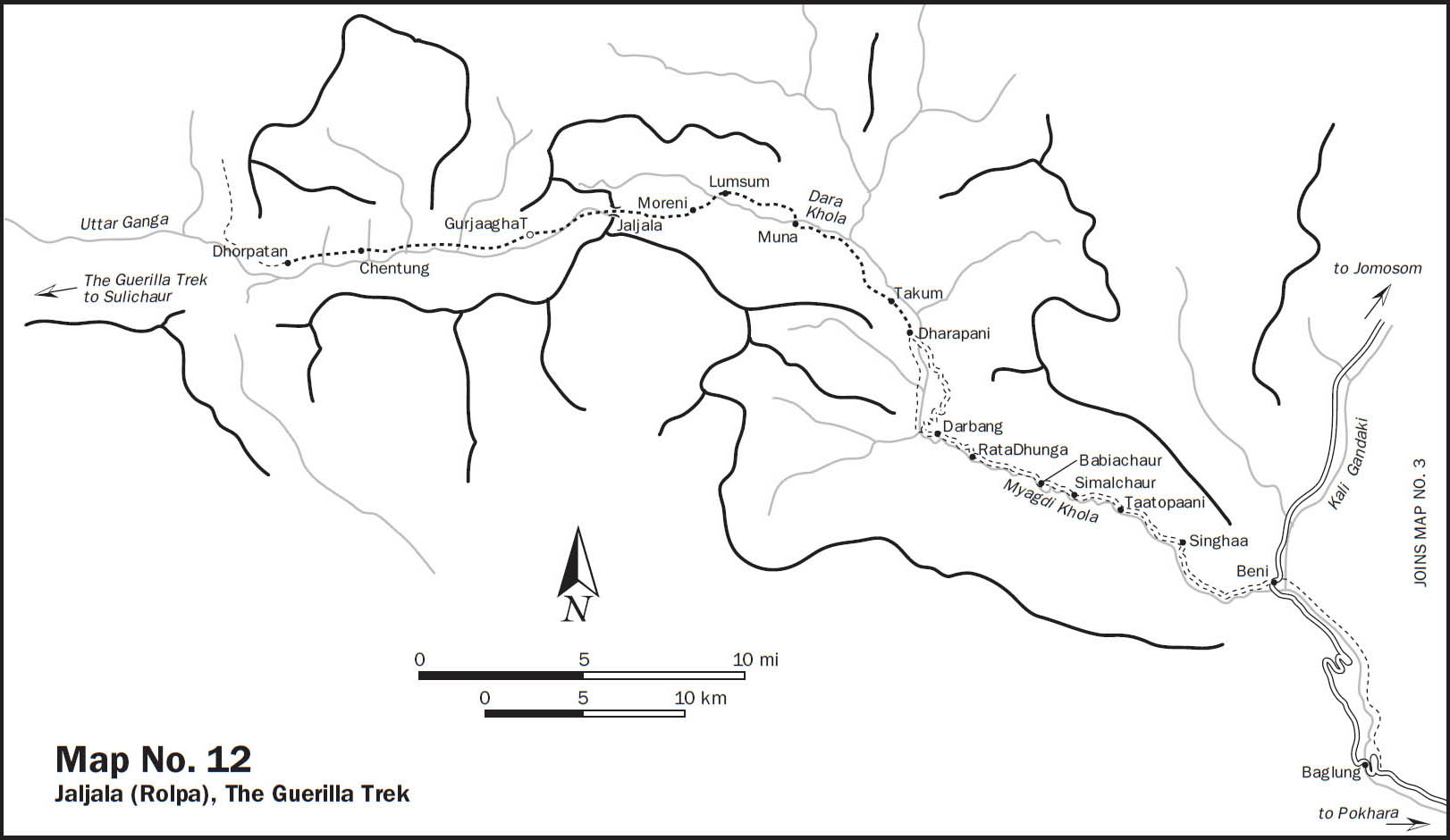 .
.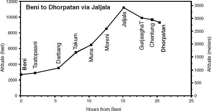 .
.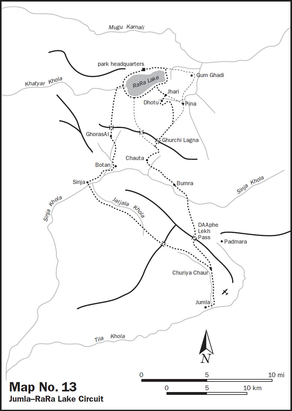 .
.