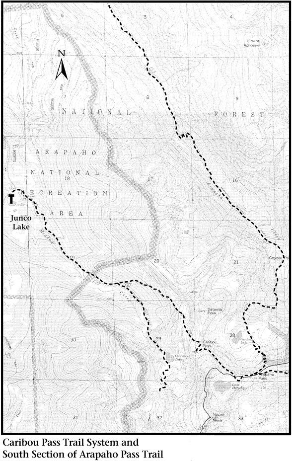
Caribou Pass Trail
The trailhead for the Caribou Pass Trail is located on an unpaved road overlooking Meadow Creek Reservoir (on old maps the lake occupies a site called Sawmill Meadow). Begin by leaving US 40 about 0.5 mile east of the town of Tabernash or 3.5 miles north of the town of Fraser. Turn east onto unpaved Grand County Road 84 immediately south of the spot where US 40 crosses a railroad track via an overpass. Very soon the road forks; take the left-hand fork and stay on the main road going to Meadow Creek Reservoir (NFSR 129). Continue past the campground along Meadow Creek, and then follow the main road uphill through switchbacks almost to Meadow Creek Reservoir. Just before you reach the dam, bear left; the road climbs through forest past a great pile of sawdust left from lumbering operations. (Note: Meadow Creek Reservoir can be reached on foot via the High Lonesome Trail; see Arapaho Pass Trail, page 261.)
About 3 road miles from the dam (12 miles from the highway) above the reservoir, the road forks again. The main road (NFSR 129) goes to the right through an open grassy area. The left-hand fork leads to a parking area at Junco Lake.
From Junco Lake the High Lonesome Trail winds through meadows and woods, crossing marshes and creeks for 4.0 miles to Devils Thumb Park and a junction with the Corona Trail (see page 266). Where the way is confused in logged woodlands, follow blazes and red dots on trees and cairns.
To climb the Caribou Pass Trail, hike from Junco Lake up an old roadbed along Meadow Creek past two fallen-down log cabins; the footing is sloppy in places. After about 1.7 miles there is a trail junction. The Caribou Pass Trail goes to the left; the Columbine Lake Trail branches to the right.
The Columbine Lake Trail follows a gradual grade for approximately 175 yards to the forest edge, where it becomes increasingly steep. A level meadow appears about 0.5 mile from the trail junction; a third, smaller meadow lies above the second. The trail climbs steeply along Meadow Creek before bending to the left to wander amid boulders and trees, soon meeting the creek again and crossing it. A short climb past the creek crossing takes you to the level of the shelf on which lies Columbine Lake at tree line. The trail mucks around in marsh, half losing itself before reaching the lake several hundred yards past the stream crossing and 3.0 miles from the trailhead. Campfires are prohibited in this area.
Columbine Lake has numerous slabs of granite along its shoreline that serve well for lunch and relaxation. Glacier-quarried cliffs rise overhead, but the summit of the nearest prominent peak, Mount Neva, sits out of sight to the south.
To climb Mount Neva from Columbine Lake, circle a short way to the right around the western shore and climb a surprisingly well-constructed trail to an obvious pass in the ridge south of the lake. From the pass climb steeply up the ridge to the summit. It is a long 1.0 mile from the lake.
Back at the Caribou–Columbine Lake junction, the Caribou Pass Trail heads steeply uphill to the left. It climbs through thick subalpine forests and sunny flower-filled meadows. It crosses rivulets and passes bogs and old mine sites, all without a single switchback. But the surrounding wilderness beauty supplies ample inspiration to offset any weariness caused by the direct ascent. Soon you are above tree line and then at Caribou Pass, 1.5 miles from the junction.
It is a vast understatement to say that the view to the east from Caribou Pass is spectacular. Your eye will be drawn particularly to the double-humped summit of Apache Peak and the adjacent cone of Navajo Peak, on the right. Caribou Lake lies at tree line, 850 feet below your boots. Uphill from the lake stretches as perfect a terminal moraine as you will ever see. There is a tiny pond behind it, a memento of the melted glacier.
From Caribou Pass a 0.5-mile walk north along the ridgeline takes you to the top of Satanta Peak. South of Caribou Pass the Caribou Pass Trail follows a dramatic wagon route blasted long ago from a cliff face. Large mats of moss campion grow amid rockslides at the trail’s edge. After 0.5 mile of trail bordered by cliff and campion, you find Lake Dorothy, the highest and deepest lake in Indian Peaks, hanging in a cirque below Mount Neva. A short way down the path beyond Dorothy are Arapaho Pass and the trails to Caribou Lake and Arapaho Glacier. (See Arapaho Pass Trail, page 261, and Arapaho Glacier Trail in the East of the Divide chapter.)