 l
l
Introduction
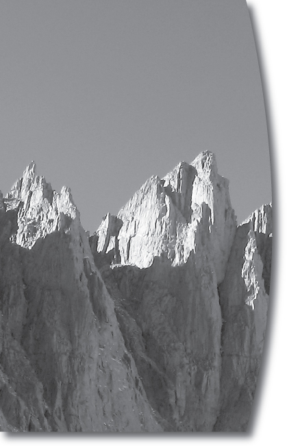
The Whitney crest, in the vicinity of Mt. Muir, as seen from Trail Camp
Mt. Whitney and the Mt. Whitney Trail
The summit of Mt. Whitney has been a sought-after point ever since 1864, when the peak was first surveyed as the highest in the United States. Although the number of ascents per year has risen hundredfold since Parsons’ time, her sentiments still ring true today. One of the most iconic peaks in the country, 14,505-foot Whitney stands 72 feet higher than Colorado’s Mt. Elbert, making it the highest peak in the contiguous 48 states (Alaska’s 20,320-foot Denali is the highest in the United States).
Mt. Whitney’s top is a desired destination for reasons other than its lofty elevation: It’s a beautiful peak, in easy driving reach of 30 million people, and the challenging but non-technical trail makes reaching the summit an attainable goal for almost anyone in good shape. The steep, eastern face of Mt. Whitney is exquisite—the last in a dramatic series of jagged peaks, nearly each one higher than the previous, culminating in the summit of Mt. Whitney. This vista is powerful from the peak’s base town of Lone Pine, 10,000 feet below in the Owens Valley.
Perhaps most important, the summit is not a giveaway. Whitney is tough enough to give you a real challenge, but not so tough that you need technical mountaineering equipment and a guide. Indeed, the 21-mile trail (up and back) is a distance most people can hike with appropriate training and planning.
It is the Mt. Whitney Trail that makes the summit an achievable goal. Before the trail was built, in 1904, it was impossible to summit in a day or even a long weekend, as Hubert Dyer, an early Sierra mountaineer and a charter member of the Sierra Club, reported in 1893:
To one standing near these structures, the stupendous mass of the Sierras seems hanging over them, and the summit of Whitney but a little way off. Yet it is about 70 miles by the shortest trail to the summit. There are stories told of men who have climbed the great eastern face. Though possible, it is a dangerous undertaking.
Today, about 10,000 people each year successfully reach the top of Mt. Whitney by the easiest route to the summit, the well-maintained, 10.5-mile Mt. Whitney Trail, which ascends one route up that “great eastern face.” There’s no reason why you can’t be one of them.
The goals of this book are threefold. First, it aims to provide novice hikers and hikers new to the high-elevation Sierra Nevada with the background information to safely summit Mt. Whitney—or to know when conditions such as health or weather mean it’s time to turn around and make another summit bid in the future. It is also meant to provide the information all hikers need to plan a summit bid: details on wilderness permits, what to eat and where to sleep in Lone Pine, what gear is essential, and, of course, everything you need to know about hiking up the Mt. Whitney Trail itself. This book will also give you a better understanding of the human and natural history of the Mt. Whitney area.

The final switchback before Trail Crest
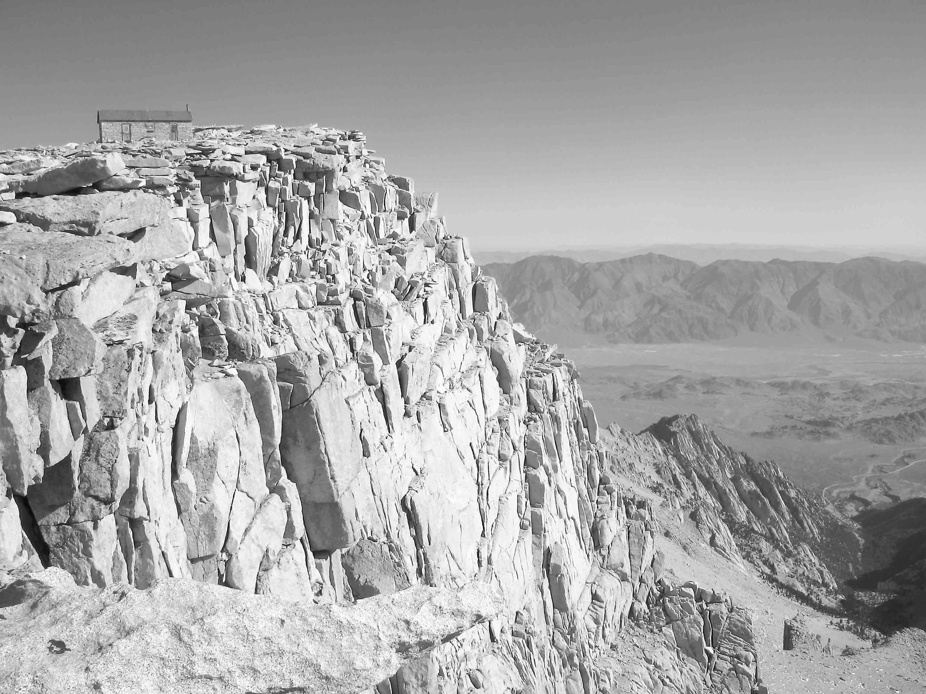
Mt. Whitney’s summit and the Smithsonian Institution research hut
Many people, especially dayhikers, will rightfully question the notion of carrying a guidebook to the summit of the peak. When will you have time to admire plants or geologic features on the ascent? My advice is to read the sections “Precautions and Considerations” and “Preparations and Planning” before your hike. Then photocopy the route description, elevation profile, sketch map of the route, and the labeled panorama from the summit to carry on your hike. The rest of the book can be a souvenir of a wonderful hike, and you can read the background information at your leisure. If you are backpacking and can take a more leisurely pace, consider carrying the entire book up (it is, after all, only 152 pages). You might find yourself looking at the plants and geologic features along the trail and be pleased to learn more about them. Or, as you eat a snack, you can read a little about the history of Mt. Whitney. Regardless of how you do it, you’re sure to fall in love with this iconic peak.
Human History
As a mountaineering destination, a survey point, a scientific laboratory, or simply as the backdrop for western films, Mt. Whitney has long captured people’s interest.
EARLY VIEWS OF MT. WHITNEY
The first white men to see Mt. Whitney were probably members of a party led by western explorer Joseph Walker in 1834. They traveled south from the Truckee River, passing through Owens Valley before crossing to the western side of the Sierra Nevada at Walker Pass. However, these men were not surveyors and did not know which of the many peaks along the escarpment was the highest, much less that one peak had the distinction of being taller than the already well-known Cascade volcanoes.
Over the next three decades, as various mining booms occurred, ever more people moved to Owens Valley and the surrounding mountains, but most did not venture deep into the Sierra. It was only on July 2, 1864, when Mt. Whitney was first viewed and surveyed from the west, that it achieved its status as highest in the country. (Whitney relinquished this title in 1959, when Alaska, with its 20,320-foot Denali and 17 other peaks taller than Mt. Whitney, was admitted to the United States.) On that day, William Brewer and Charles Hoffmann, respectively a botanist (and field crew leader) and topographer for the California State Geological Survey, made the first ascent of 13,570-foot Mt. Brewer and saw the layout of the southern High Sierra for the first time, including the location of the tallest peak in the range.
RACE FOR FIRST ASCENT
The race to ascend the high point began two days later. Two other members of the geological survey, Clarence King, a geologist and keen and dare-devilish explorer, and Dick Cotter, an assistant, begged permission to head to the peak. They went through uncharted country: across the Kings-Kern Divide and into the Kern River drainage. Thinking they were heading for the Sierra Nevada’s high point, they ascended along what is now called Shepherd Creek, and summited not Whitney but 14,019-foot Mt. Tyndall, the Sierra’s eighth-highest peak. From the top, they surveyed the surrounding peaks, noting several that were higher, including Mt. Whitney. Upon their ascent, King named Mt. Tyndall in honor of a famous British scientist.
Although King and Cotter had to head north to continue their survey after climbing Tyndall, the desire to be the first to summit Mt. Whitney stuck with King. The following day, he received permission to temporarily leave the party and make a second attempt to reach Mt. Whitney. With two cavalrymen and a few horses, he again set out for the Kern River drainage, this time via the Hockett Trail from the San Joaquin Valley. En route, he passed today’s Mt. Langley, calling it “Sheeps Peak,” and continued to Mt. Whitney. He made it within about 300 feet of the summit, before he had to turn back due to bad weather.
In 1871, King made a third attempt, this time from Owens Valley, via a southern route. In writing about the stormy day when he ascended the “true” summit of Mt. Whitney, King noted what he thought was Mt. Tyndall, some distance to the north. But two years later, a family from Lone Pine climbed this peak, found King’s summit note, and informed him that he had actually climbed what is known today as Mt. Langley (his “Sheeps Peak”), some miles south of Mt. Whitney.
It wasn’t entirely King’s fault, for on his map, the name “Mt. Whitney” was mistakenly attached to Mt. Langley. In 1870, Charles Hoffmann led a survey to the Inyo Mountains, and on maps later created, it was falsely reported that Mt. Langley was Mt. Whitney. Ironically, the error was in part due to King, who made faulty compass measurements from the summit of Mt. Tyndall in 1864. Moreover, Langley and Whitney have similar shapes, and from lower elevations such as the location of Hoffmann’s survey team, it is difficult to distinguish which peak is higher. Two meadows on the Kern Plateau to the west of Mt. Langley are a relic of this mapping mistake, as they still hold the name Whitney.
By the 1870s, people from Lone Pine were regularly crossing into the Kern drainage to escape Owens Valley summers. They took the Hockett Trail from the east, crossed the Sierra Crest at Cottonwood Pass, and then traversed the Kern Plateau, before dropping to the Kern River near today’s Kern River ranger station, at the southern boundary of Sequoia National Park. In 1873, three men, Charles D. Begole, Albert H. Johnson, and John Lucas, who were camped along the Kern River, decided to leave their fishing camp for a few days and head toward the Sierra Crest. On their trip, they summited first Mt. Langley, and then, on August 18, 1873, they made the first ascent of Mt. Whitney from the southwest. They left the Hockett Trail, traveled north, probably passing the vicinity of Crabtree Meadow, before climbing east toward Mt. Whitney. In subsequent weeks, two more parties successfully climbed Whitney: William Crapo and Abe Leyda in late August, and William Crapo, William L. Hunter, Tom McDonough, and Carl Rabe on September 6, 1873. (The men in the second and third ascent parties attacked the claims made by the three fishermen, but the fishermen’s truthful story eventually prevailed.)

The view south from Mt. Whitney, including from left to right, Mt. Langley, Mt. McAdie, Olancha Peak, and Cirque Peak
Meanwhile, upon hearing that he had ascended the wrong peak in 1871, Clarence King left his survey job on the East Coast and rushed back to California to attempt Whitney again. On September 19, 1873, King finally succeeded, along with partner Frank Knowles, but they had to settle for fourth place.
OTHER EARLY ASCENTS
On October 21, 1873, the naturalist John Muir pioneered a new route from the east that is now known as the Mountaineer’s Route. However, for many years, the non-technical route up the western face remained the most popular. Indeed, once the early summiteers showed that it was fairly easy to climb Mt. Whitney from the west, it quickly became a sought-after climb. Parties continued to follow the Hockett Trail across the Sierra Crest and then traveled north via the Kern Plateau, Rock Creek, and Guyot Pass to reach today’s Crabtree Meadow. Some parties would reach the summit in a long day from Crabtree Meadow, but most established a higher camp near Guitar Lake. It was via this route that, in the summer of 1878, the first woman, Anna Mills, climbed to the summit.
In 1896, A. W. de la Cour Carroll, a charter member of the Sierra Club from Lone Pine, was the first to describe an ascent via a route similar to today’s Mt. Whitney Trail. His party of five men and three women left the vicinity of Outpost Camp early on August 28, 1895, and followed Lone Pine Creek up to Consultation Lake. It appears that from there they climbed toward Whitney Pass (well south of Trail Crest). From there, they descended toward Hitchcock and Guitar lakes, where they spent a night, before climbing the mountain. This circuitous route took them down 2500 feet and then immediately back up again to avoid a traverse of the pinnacles south of Mt. Whitney’s summit. Luckily, on the return, Carroll identified a passable route closer to Trail Crest, shaving time and distance from their descent. Although others took advantage of this route in the following years, most hikers continued to eschew the steep talus chutes up the east face and instead journeyed over Cottonwood Pass. Indeed, the trail from Crabtree Meadow remained incredibly popular: In 1903, a Sierra Club party of 103 ascended via this route.
THE MT. WHITNEY TRAIL
In the early 1900s, Gustave Marsh, a newcomer to Lone Pine, realized that increased Mt. Whitney tourism would benefit the little town, and a more direct trail to the summit might attract more people. Moreover, he envisioned a trail to the summit passable by pack stock. Initially, most townspeople didn’t share his enthusiasm, but Marsh nonetheless began fundraising, and before long, Lone Pine citizens pitched in as well, funding much of the work. Letters about the project to Marsh’s friend, meteorologist Alexander McAdie, were published in the Sierra Club Bulletin, undoubtedly as much to elicit money from its members as to report on progress.
Work on the trail commenced in August of 1903, when a crew of 14 Lone Pine residents built a trail that followed a course similar to the route that A. W. de la Cour Carroll had pioneered nearly a decade earlier. The men toiled to build a route through the field of talus, where moving one boulder often initiated an avalanche of rock that damaged the trail down the slope. When they reached Whitney Pass (just north of Mt. McAdie, a mile southeast of today’s Trail Crest), they ran out of funds and work stopped. Two months later, having procured additional funds, they continued working toward the summit. The inhospitable fall weather caused half the workers to abandon the job, and a winter storm in late October forced the others to retreat as well. After an additional 10 days of work the following summer, the trail was completed to the summit on July 18, 1904. The crew celebrated with a large bonfire on top—after all, they now had a trail passable by pack stock, which carried the wood to the summit.
In 1909, plans were made to build a research shelter for the Smithsonian Institution atop Mt. Whitney, requiring that repairs be made to the trail. Marsh received the contract to construct the summit hut, with the understanding that he would first reestablish the trail where rock slides and avalanches had made the track impassable to stock.
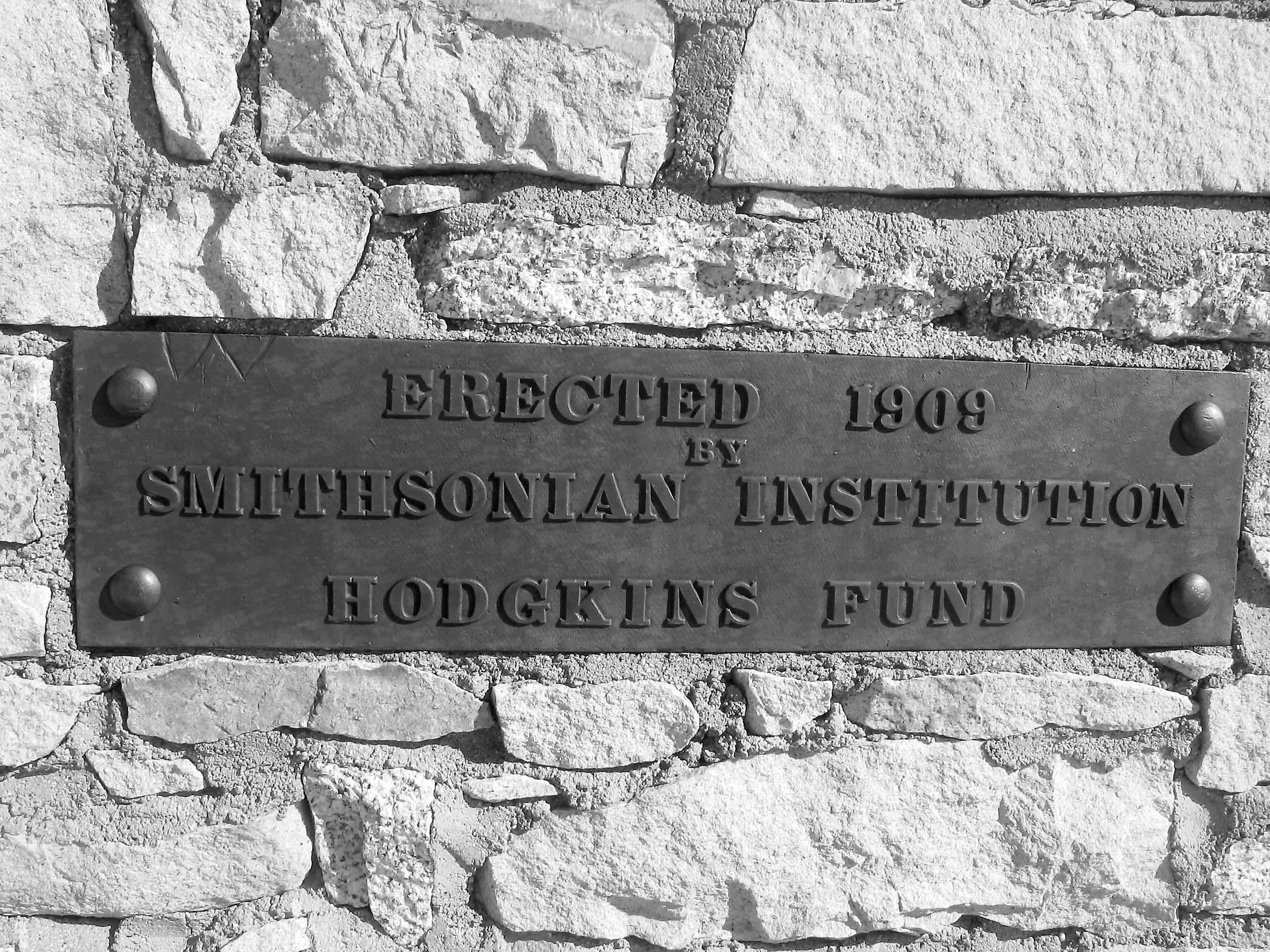
The plaque on the Smithsonian Institution research hut on the summit
By the early 1920s, however, the trail was again in disrepair due to rockslides, and stock could not reach even the Sierra Crest. Reconstruction began in 1928 as part of an effort to refine the estimated height of Mt. Whitney by leveling from Lone Pine to the summit. Crews from Sequoia National Park worked simultaneously on the Mt. Whitney Trail and on the newly constructed 67-mile High Sierra Trail. By late 1929, stock parties could once again reach the top of Mt. Whitney. In the early 1940s, more work was done on the trail, including the rerouting of the 99 switchbacks to avoid ice fields. Since then, the trail has been maintained, but not much has changed.
What has changed are wilderness ethics. To limit wear on the trail, pack stock were banned in the 1970s, and a camping ban was instituted to protect the fragile lakeshore resources at popular Mirror Lake. Bear canisters are now required, and in 2007, the toilets along the trail were removed and hikers are now required to pack out their solid waste.
Natural History
When you take a walk in nature, you are continuously passing natural history stories captured in the plants, animals, rocks, and sky. These stories have two dimensions. First, each organism or rock you pass is named based on its physical characteristics. However, what you see also holds evidence of past events and ongoing processes. The living organisms along the Mt. Whitney Trail are there because they have adapted to deal with the long, cold, wet winters and the dry summer months. Unlike those in other alpine regions of the world, most of the plant species here evolved from desert-dwelling species. Some traits, like the low stature of alpine plants and the small leaves of plants on dry soil, are visible to every passerby, while other traits are physiological in nature and measured by inquisitive scientists. The rocks, likewise, hold clues to their history. For instance, the chemical composition of the rock informs scientists where the rock originated. This section provides an overview of the natural history along the Mt. Whitney Trail, and I encourage you to observe as you’re marching along.
GEOLOGY
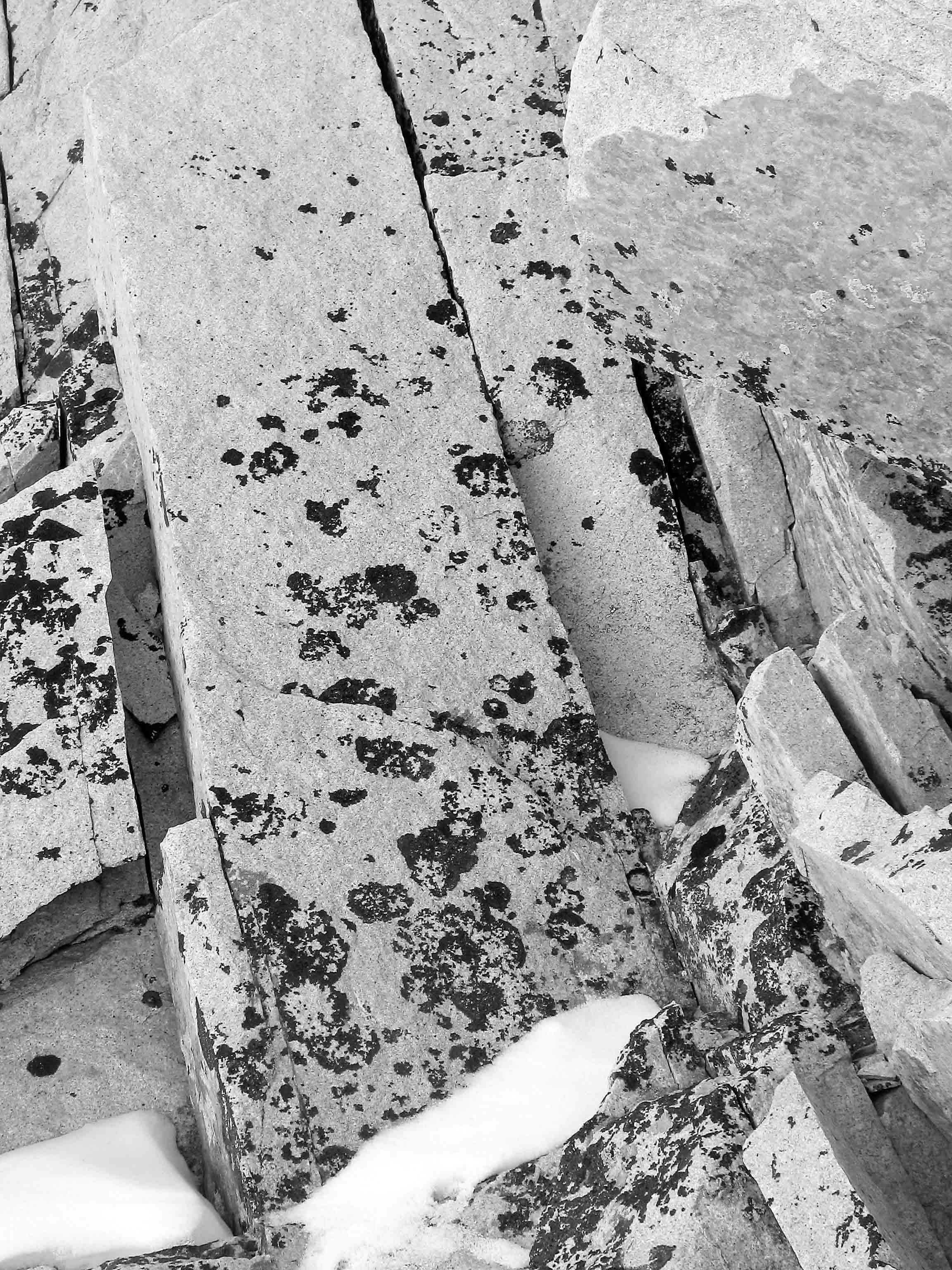
The entire Mt. Whitney Trail travels over rock known as the “Whitney granodiorite.” Granodiorite is an intrusive igneous rock that originated as molten magma solidified belowground, forming a pluton—an irregular-shaped mass of intrusive rock. Granodiorite is mostly composed of five minerals: quartz, plagioclase (a type of feldspar), potassium feldspar, hornblende, and biotite. The rock’s salt-and-pepper-speckled appearance is created by the combination of light-colored quartz and feldspar together with black-colored hornblende and biotite. (Compared to granite, granodiorite has a higher percentage of hornblende and biotite.) Each mineral has a specific chemical composition, shape, hardness, and other characteristics. For instance, the darker-colored minerals have a greater proportion of iron and magnesium than the lighter-colored minerals. In both granodiorite and granite, each mineral’s individual crystals are large enough to be visible with the naked eye, indicating the rock cooled relatively slowly.
To understand how the granodiorite formed, we must turn to plate tectonics. The Earth’s surface can be divided into at least 15 plates, relatively thin pieces of solid rock (the crust) that float and rotate on the molten material (the mantle) that lies beneath them. As they move, the individual plates may separate, slide past one another, collide, or do any combination of these motions. From about 120 million to 80 million years ago, the Farallon Plate collided with and slid (subducted) beneath the North American Plate. The subducting material was subjected to high temperatures and pressures, causing it and the overlying crust from the North American Plate to melt. Between 88 million and 83 million years ago some of this material solidified into the rock formations that comprise the Whitney Intrusive Suite, a collection of three plutons, including the Whitney granodiorite. These plutons and others comprise the Sierra Nevada batholith (a batholith is a collection of plutons with an exposed surface area greater than 40 square miles).
The crystals comprising the Whitney granodiorite are large compared to the crystals in granites and granodiorites elsewhere in the Sierra. This is because the pluton is nested in the middle of the Whitney Intrusive Suite, where the outer layers of rock provided insulation, which allowed the magma to cool slowly and the individual crystals to grow larger before the magma solidified completely. Especially noteworthy in the Whitney granodiorite are large crystals of potassium feldspar, termed “pegmatites.” Rectangular in shape and often measuring 2 inches in each dimension, these crystals protrude from boulders. If you’re lucky, you may see a crystal in which concentric rectangles of small dark crystals are visible. These are small hornblende crystals that were engulfed in the more rapidly growing feldspar. Along the Mt. Whitney Trail, these large crystals are most common on the slope above the John Muir Trail junction.
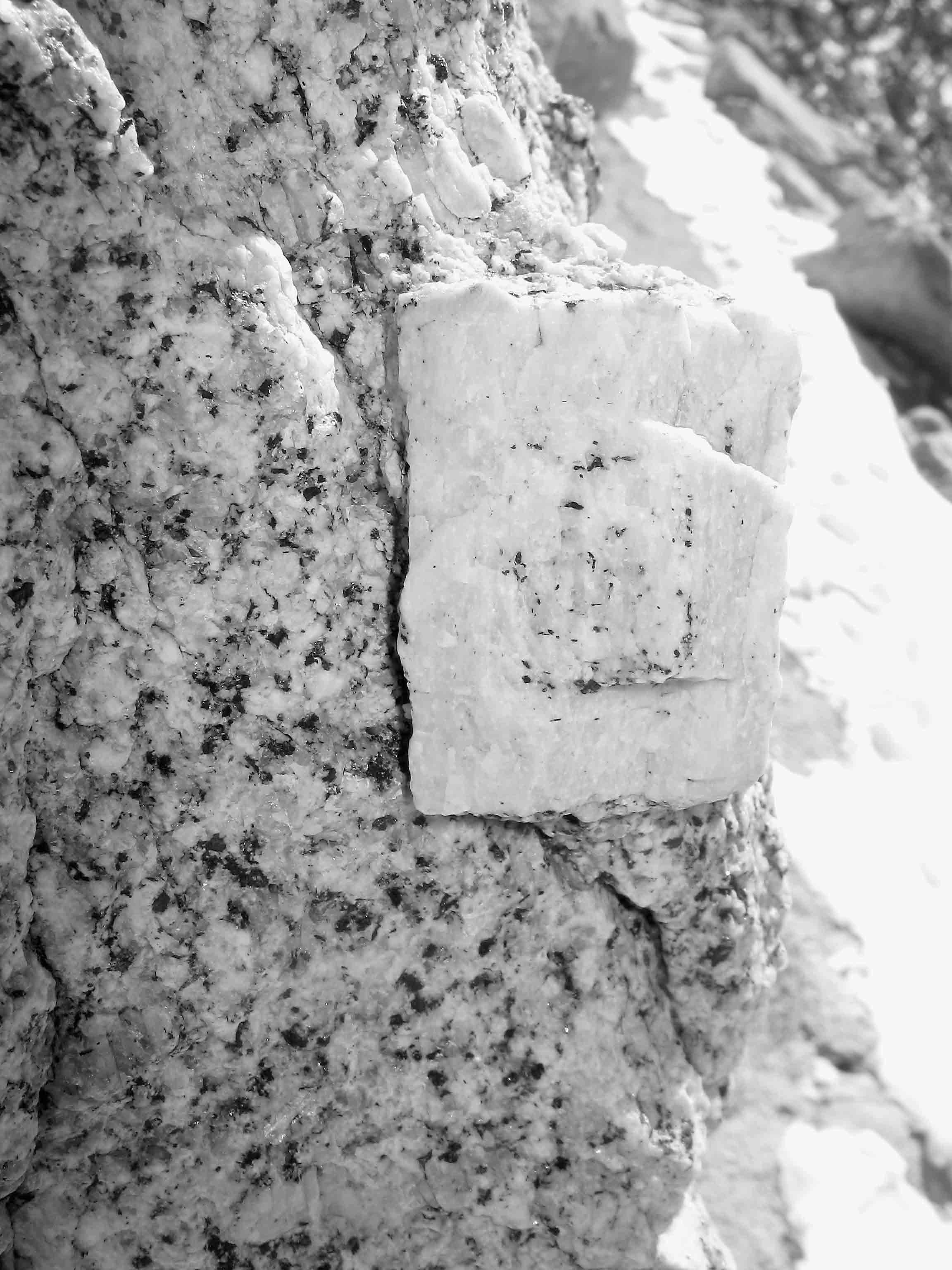
A zoned feldspar crystal embedded in a granite boulder
As you hike up the Mt. Whitney Trail, you are likely to see more geologic features than just the evidence of the plutons. Here are a few of the highlights:
Joints: These natural fractures within the granite formed because the rock contracted as it cooled. The pinnacled profile of the Sierra Crest from Trail Crest to the summit of Mt. Whitney is due to jointing. In addition, the regular, large-scale fractures in the rock between the Hitchcock Lakes and Guitar Lake, on the west side of Mt. Whitney, are along joints. On a finer scale, the boulders perched on the summit of Mt. Whitney formed by jointing. Multiple sets of joints caused the rock to fracture into blocks, which eroded to form fairly rounded giant boulders.
Avalanche chutes: These usually form along joints, where the fractured rock is displaced by water that alternately freezes and thaws in the cracks. As a result, the loose rock is carried downslope by gravity, often entrained by snow. These avalanches not only remove rock, but also polish the chutes. In places, giant slides are truncated some distance above today’s valley floor, at the boundary between “steep avalanche chute” and “nearly vertical wall.” The bottoms of the much older avalanche chutes were cut off by the more recent glaciers, and this transition marks the height to which the valley was once filled with ice. Avalanche chutes are obvious on the north face of Mt. Hitchcock, the steep peak to the west of Trail Crest that is seen from Trail Crest to the summit of Mt. Whitney. The boundary between unglaciated and glaciated rock is most obvious if you look north while on the 99 switchbacks: Pinnacle Ridge and the east face of Mt. Whitney were not glaciated, while the basin below was.

The view southwest from Mt. Whitney, including from left to right, the Hitchcock Lakes, Mt. Hitchcock, and the Kaweah peaks
Rock glaciers: Like ice glaciers, rock glaciers—rocks that are cemented together by ice—move slowly downslope due to gravity. Rock glaciers are often mistaken for moraines (see next entry), as both appear to be poorly sorted collections of boulders. However, rock glaciers are characterized by a notable steep front and often a flattish, rippled top. Along the Mt. Whitney Trail, there are several large rock glaciers in the basin east of Mt. Whitney, including one just to the northwest of Trail Camp. Their U shapes are readily visible as you approach the cables on the 99 switchbacks.
Moraines: These ridges formed by the accumulation of rocks and other debris that was carried downslope by a glacier. Lateral moraines form along the sides of the valley, while a terminal moraine marks the farthest down-valley extent of the glacier. Along the Mt. Whitney Trail, most moraines have been overrun by rock glaciers.
Glacial polish: These smooth, shiny surfaces are created when the sediment at the bottom of a glacier is scraped across rock outcrops, evening and smoothing them, and leaving a shiny surface. However, coarse rocks dragged along by the glacier may leave grooves and striations. Hunt for sections of glacial polish as you walk along the ridge a little below Trailside Meadow.
VEGETATION
Climbing up more than 6000 feet takes you through four vegetation zones, each of which can be further divided based on the slope’s aspect and steepness. Depending on temperature, moisture availability, and other factors, these zones either begin and end abruptly or grade into one another.
Montane Zone: Whitney Portal lies in the Montane Zone, which, in the southern Sierra, extends from about 7500 feet to just above 9000 feet. Along the Mt. Whitney Trail, white firs and Jeffrey pines dominate the forested sections of this zone. However, due to the steep aspect and dry soils at this elevation range along the trail, you will mostly be walking through the montane chaparral community. Drought-resistant evergreen shrubs such as mountain mahogany and bush chinquapin are common members of the community.
Subalpine Zone: The Subalpine Zone is loosely defined as a region where tree cover thins, although forest cover can still exist—from around 9500 to 11,000 feet in elevation in the Whitney region. The understory is usually sparse and the soils poor. In the southern Sierra, this zone is dominated by lodgepole pine, foxtail pine, and whitebark pine, the latter of which is rare along the Mt. Whitney Trail. On flatter slopes, such as near Lone Pine Lake, a dense mono-stand of lodgepole pine is common, while tree cover lessens and foxtail pines become more common in steeper areas. The latter is an important member of the subalpine community only in the southern Sierra. The Subalpine Zone ends where trees can no longer establish. Along this trail, you will find the last trees about half a mile above Mirror Lake.
Alpine Zone: The Alpine Zone begins above timberline, usually around 11,000 feet in the southern Sierra, and includes only shrubs, herbs, and grasses. In regions with sufficient water, you may encounter meadows, a plant community found along the Mt. Whitney Trail only at Trailside Meadow and near Trail Camp. Meadows have a dense cover of grass interspersed with a collection of wildflowers. Elsewhere, ground cover is sparser. In the Alpine Zone, species composition can be quite varied, depending on small differences in location, as each species has individual requirements for establishment and growth. Many species grow alongside boulders, with their roots seeking the moister soil beneath the rock. Cushion plants are common in sandy flats between rocks, as growing close to the ground alleviates wind chill and the temperatures can be many degrees warmer. As the elevation increases and the growing conditions deteriorate, the species diversity declines.
Barren Rock: At the highest elevations, no plants can survive. On north-facing slopes, the growing season may be too short, for winter snows may remain on the ground long into summer. On exposed, west-facing slopes, the winter temperatures may be too extreme, as winter winds often strip such slopes of all insulating snow cover. Along the last mile to the summit of Mt. Whitney, even the sky pilot and alpine gold disappear, as a combination of winter temperatures, winter winds, and growing season length make the environment too stressful.
Since the Mt. Whitney Trail traverses so many vegetation zones, there is a rich diversity of more than 150 plant species growing alongside the trail. The following is a small subset of species that grow along the trail. They were selected to represent the species you are most likely to notice—some are common along the trail for considerable distances, while others appear only a few places but are abundant and hard to miss. There is a bias toward the higher-elevation species, for it is at these elevations that you will be going most slowly and likely staring at the ground.
For each species, I have provided the common name and scientific name (in parentheses). The species are listed in the approximate order they appear along the Mt. Whitney Trail. This is followed by a brief description to aid in identifying the species.
When at home, check out the following website, which is a wonderful resource with color photos of many of California’s plants: calphotos.berkeley.edu/flora.
Lichens growing on north-facing talus
HERBS AND SHRUBS
Mountain mahogany (Cercocarpus ledifolius): This large shrub dots the slopes adjacent to the trail from the start up to approximately 9200 feet. It becomes less common about halfway between the North Fork of Lone Pine Creek crossing and the Lone Pine Lake junction. It has small, oval-shaped, leathery leaves, but it is most easily distinguished beginning midseason when it is covered with distinctive seeds: Each seed bears a 1-inch, curled tail that is densely covered in branched hairs. These hairs catch the light, giving the entire plant a wonderful glow.
Fernbush (Chamaebatiaria millefolium): A common large shrub that grows between Whitney Portal and the top of the dry slopes below the Lone Pine Lake junction, this species is named for its much-dissected leaves that resemble fern fronds. The dark green foliage has a strong odor and is covered with glands and hairs. Its five white petals ring a dense cluster of yellow stamens, the pollen-producing male reproductive parts.
Sierra angelica (Angelica lineariloba): A member of the carrot family, Sierra angelica is common on the slope leading to the Lone Pine Lake junction. Usually 3 to 4 feet tall, it bares many small, white flowers in a large, spherical head. As indicated by its scientific name, its leaves are dissected into long, linear lobes.

Sierra angelica (Angelica lineariloba)
Scarlet penstemon (Penstemon rostriflorus): There are many species of penstemon in the Sierra Nevada, inhabiting environments from wet meadows to high sandy plateaus. The flowers come in all shades of reds, purples, and blues, and are always identifiable by their long, tubular flowers. In the Sierra Nevada, the scarlet penstemon (or Bridge’s penstemon) is the species with the most vibrant red flowers attached to a single long stalk. It is present on many dry, sandy slopes up to 10,500 feet. The Mt. Whitney Trail is no exception, and although this species is present until you reach Mirror Lake, it is especially common below the Lone Pine Lake junction.
Rothrock’s beardtongue (Keckiella rothrockii): A relative of the penstemons, this light pink, flowered herb is common from Whitney Portal until a short distance before the South Fork of Lone Pine Creek crossing. The flowers are smaller and wider than those of scarlet penstemon, but they are likewise tubular.
Inyo meadow lupine (Lupinus pratensis): This tall lupine occurs in the wet area just downstream of the first crossing of Lone Pine Creek. A member of the pea family, it has mostly purple flowers on elongate flowering stalks. Its 5 to 10 leaflets are each 1 to 3 inches long and fuse to a single point—making it palmate, like your hand. The peapod-like fruits are hairy to woolly.
Mouse-tail ivesia (Ivesia santolinoides): Along the Mt. Whitney Trail, you will see this species only once, but you can’t miss the large cluster of these dainty white flowers near the Mt. Whitney Zone sign (just beyond the Lone Pine Lake junction). The leaves of this species certainly resemble mouse tails, with 2- to 4-inch stalks of densely clustered, very tiny, and hairy leaflets. Each flower sits atop a loosely branched, long stalk, and each of the five petals resembles a miniature rose petal—indeed, this species is a member of the rose family.
Wavy-leaved paintbrush (Castilleja applegatei): A common species on dry slopes throughout the Sierra Nevada from 4000 to 11,000 feet, this paintbrush grows along the Mt. Whitney Trail up to around Mirror Lake. It is especially common on the switchbacks just after you enter the Mt. Whitney Zone and again on the switchbacks above Outpost Camp. It has heads of red-orange tubular flowers, but if you look closely, you’ll see that much of the color is not from the flower but from the tips of the lobed leaves below each flower. This species can always be distinguished from other paintbrushes by its wavy-margined leaves.
Bush chinquapin (Chrysolepis sempervirens): This shrub, a relative of oaks, grows from Whitney Portal to Mirror Lake. The backside of the leathery leaves is a beautiful golden color, and the fruit is a spiny sphere. It is hard to miss on the switchbacks between Outpost Camp and Mirror Lake.
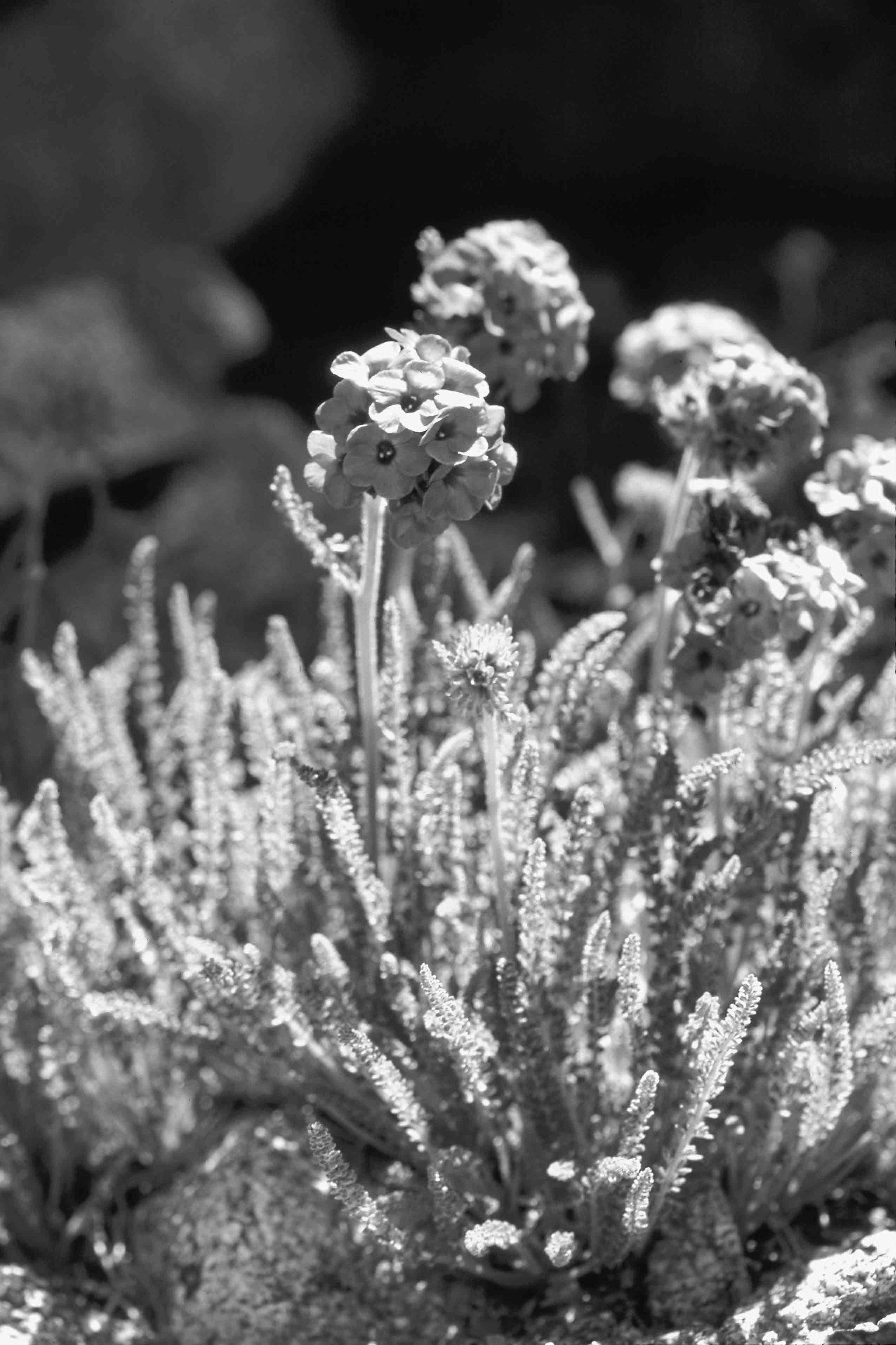
Mountaineer’s shooting star (Dodecatheon redolens): A common species in wet meadows throughout the Subalpine and Alpine zones of the Sierra Nevada, the mountaineer’s shooting star finds few appropriate habitats along the Mt. Whitney Trail. You are most likely to notice it in Trailside Meadow, where it is the dominant herb. Its stalks are approximately a foot tall, and its narrow leaves, which attach to the base of the plant, are nearly that long. Its eponymous flowers have five bent-back lavender petals, the trail of the shooting star. The yellow petal bases are fused together, and the stigma and bulky stamens, the female and male reproductive structures, form the tip of the shooting star.
Cliffbush (Jamesia americana): Appropriately named cliffbush is a light pink, flowered shrub that often grows in cracks in the cliffs. It has small leaves with serrate tips, and its spreading branches often hug slabs of rock, reminiscent of fruit trees grown as an espalier. Along the Mt. Whitney Trail, cliffbush is common between 11,000 and 12,000 feet, mostly along the north-facing sides of outcrops.
Sierra primrose (Primula suffrutescens): This is one of the Sierra’s most cheerful flowers, with five bright magenta petals that fuse into a yellow ring. This low-growing shrub emerges at the edge of boulders along the Mt. Whitney Trail, mostly between Trailside Meadow and Trail Camp, although a few individuals also grow on the switchbacks above the Mt. Whitney Zone sign. The small, slightly fan-shaped leaves have a serrate outer edge.
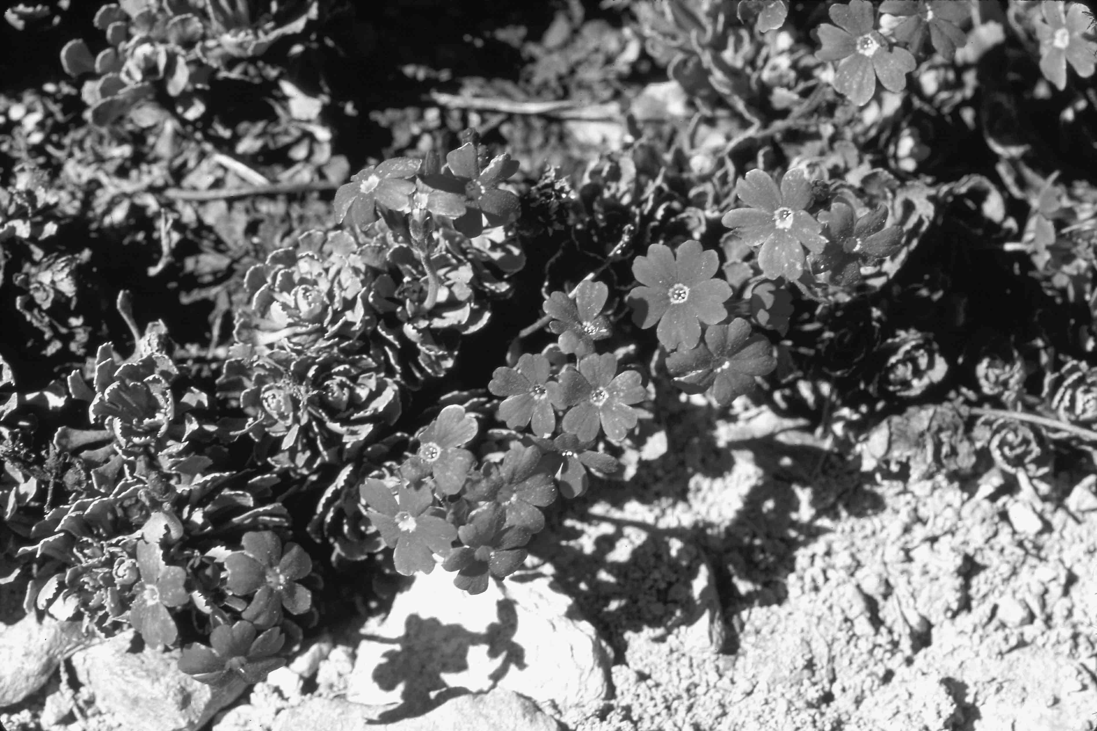
Sierra primrose (Primula suffrutescens)

Rockfringe (Epilobium obcordatum)
Rockfringe (Epilobium obcordatum): Rockfringe joins the Sierra primrose beneath boulders between Trailside Meadow and Trail Camp. It, too, has bright magenta flowers, but its flowers have four large, very thin petals. A late-blooming species with quite small leaves, it just emerges when most other species are already blooming, and its abundant flowers appear in late summer, as the others fade.
Wax currant (Ribes cereum): This shrub, also called squaw currant, is present along the trail from about 11,000 to 12,500 feet, disappearing as you approach the section of the switchbacks with the handrail. Like all currants, its leaves resemble maple leaves, but with more rounded lobes. By midsummer, the plant bears small, red berries that are edible but not particularly tasty. Unlike most other currants at lower elevations, this species does not have thorns.
Mountain monkeyflower (Mimulus tilingii): Of the approximately 40 species of monkeyflowers in the Sierra Nevada, this is one of the three species you will encounter frequently at high elevations. Along the Mt. Whitney Trail, it is common between Trailside Meadow and Trail Camp. Its yellow flowers are tubular, with two petals attached above and three petals arranged below the tube’s red-spotted mouth. (The central petal on the bottom is lobed, giving the appearance of two petals.) As with many monkeyflowers, this species grows near trickles of water, both alongside streams and under moist overhangs.
Oval-leaved buckwheat (Eriogonum ovalifolium): This cushion plant becomes common just beyond Trail Camp, growing in sandy patches between boulders. The leaves are densely covered in fine hairs, giving the leaf blades a frosted appearance. Spherical heads of small white flowers are born on 2- to 4-inch stalks. The heads turn pink or reddish by late season, as the flowers go to seed.
Cut-leaf daisy (Erigeron compositus): This small daisy is common throughout the switchbacks. It is best identified by its three-lobed leaves (half inch to an inch in size), because the flowers come in two different forms: Some are characteristic little daisies, with bright yellow centers surrounded by purple rays, but many individuals lack the rays.
Gray chickensage (Sphaeromeria cana): Also known as “tansy,” this relative of the sagebrush grows along the bottom half of the switchbacks (between 12,000 and 13,000 feet), though you may spot a few straggling individuals west of Trail Crest. This small shrub grows in sandy patches between boulders on talus fields. It has a disc of minute, cream-colored flowers, which, from a distance, appears as a single, small head with no rays, reminiscent of a button.
Granite draba (Draba lemmonii): This member of the mustard family, common along the 99 switchbacks, is a cushion plant, and hugs rocks, especially near small trickles of water. The tiny oval-shaped leaves are distinguished by their long, hairy edges. In early season, the often large mats are covered with small, yellow, four-petal flowers.

Club-moss ivesia (Ivesia lycopodioides)

Alpine gold (Hulsea algida)
Club-moss ivesia (Ivesia lycopodioides): Like the lower-elevation mouse-tail ivesia, this species has stalks of closely clustered miniature leaflets. However, the leaves of the club-moss ivesia are not hairy and are therefore a brighter green. Its five-petal, yellow flowers are borne at the end of approximately 4-inch stalks, which emerge from a basal cluster of leaves. Along the Mt. Whitney Trail, club-moss ivesia grows mostly at the highest elevations and is most commonly seen toward the top of the switchbacks and near the junction with the John Muir Trail. At these high elevations, it often emerges from cracks in slabs, while at lower elevations it is common in wet meadows.
Alpine gold (Hulsea algida): A type of daisy, alpine gold becomes common around 12,500 feet and grows nearly to the summit of Mt. Whitney. While most of the species along the switchbacks are small (and bear small flowers), alpine gold has large yellow flowers on 6- to 8-inch stalks. Its rather thick leaves are long, narrow, and gland-dotted, with slightly wavy margins. Despite its strong odor, this species is a favorite food of bighorn sheep and pikas. Along the final miles to the summit, you may encounter small piles of clipped alpine gold leaves. These “hay piles” are left by pikas who make them to dry the leaves for winter storage.
Sky pilot (Polemonium eximium)
Sky pilot (Polemonium eximium): Along the Mt. Whitney Trail, alpine gold shares the highest habitats with sky pilot. The showiest of High Sierra species, the sky pilot boasts a 2- to 3-inch diameter, spherical head of vibrant purple flowers. The leaves are deeply dissected, have a pungent odor, and are covered with small glands. This species grows among the cliffs on some of the Sierra’s highest peaks and is another favorite food of bighorn sheep and pikas.
TREES
White fir (Abies concolor): Growing from Whitney Portal up to around 9000 feet, the white fir, like all firs, is easily distinguished from pine trees: Its needles attach singly to the branches, instead of being bundled into clusters called fascicles. The needles are well over an inch in length, and the bark of the older trees is light in color. Don’t expect to find any fir cones lying on the ground, as the squirrels shred them before they fall.
Jeffrey pine (Pinus jeffreyi): The Jeffrey pines are the towering trees at Whitney Portal that grace the slope all the way up to about 9000 feet. Its long needles are clustered in groups of three, and its large, oval cones are “gentle”—meaning that the tips of the cone’s scales are turned inward. Jeffrey pines rarely form a continuous forest cover; instead, they occur singly or in small groups, mostly on dry slopes.
Lodgepole pine (Pinus contorta): The lodgepole pine is the most common tree in the subalpine Sierra Nevada, forming near monocultures on many flats and on some slopes between 9000 and 11,000 feet. Along the Mt. Whitney Trail, the lodgepole pine is most common for the half mile below the Lone Pine Lake junction, although it occurs occasionally to above Mirror Lake. It is distinguished by needles that are borne in clusters of two; fine, scaly bark; and approximately 1.5-inch pinecones that are usually abundant at the base of trees.
Foxtail pine (Pinus balfouriana): The foxtail pine is a southern Sierra species, and some of the largest stands occur on the west side of Mt. Whitney. Along the Mt. Whitney Trail, the beautiful trees are especially prominent at Outpost Camp, with some individuals that appear at elevations of about 11,000 feet, above Mirror Lake. These pines are distinguished by their long, dangling branches that often have needles only near the tip. The needles encircle the stem like a bottlebrush, much like their relatives, the bristlecone pines. Needles are in clusters of five, and cones are about 3 inches long.

Foxtail pines (Pinus balfouriana) near Outpost Camp
ANIMALS
Although more than a dozen mammals and at least 50 bird species inhabit the Mt. Whitney region, as you traverse the landscape, it appears nearly devoid of wildlife. Most mammals eschew human corridors, and many are nocturnal. Although many bird species are present, they are often seen only at dawn and dusk and even then only identified with the aid of binoculars. Nonetheless, it’s difficult to ascend Mt. Whitney without seeing a few common alpine (and subalpine) animals and birds. They may include any of the following:
Yellow-bellied marmots: The largest mammal commonly seen, the marmot is technically a large, heavy-set ground squirrel, approximately 2 feet in length (including its bushy tail). In the mid-elevations of the Alpine Zone, marmots are commonly seen lazing atop boulders, flattening their fat bellies into a thick pancake. They are very common (and aggressive) at Trail Camp.
Golden-mantled ground squirrels: About a foot in length, approximately a third of which is tail, this squirrel, unlike the chipmunk, does not have stripes on its head: The distinct white and black stripes extend only to its neck. Their range doesn’t extend beyond 10,000 feet, so you will see them only along the lower reaches of the Mt. Whitney Trail.
Alpine chipmunks: These tiny, skinny critters are just 6 to 7 inches in length and are easily identified by their small size and face stripes. The highest-elevation chipmunk, they range above 10,000 feet.

Yellow-bellied marmot
Pikas: These softball-sized balls of fluff have adorable Mickey Mouse ears. Relatives of rabbits, when startled, they emit a “peep-peep”—often the first evidence of their presence, as they quickly scamper into a talus pile. Unlike the rodents, pikas do not hibernate during the winter. Instead, they subsist beneath the talus on plants they have collected during the summer. If you see a pile of cut plant stems sitting on a rock, this is a pika’s hay pile being dried for winter.
Bighorn sheep: Infrequently seen along the Mt. Whitney Trail, the bighorn sheep near Mt. Whitney are from the Mt. Langley population, to the south, and wander as far north as Arc Pass, overlooking Consultation Lake. However, they rarely stray any closer to the trail. To the north, members of the Mt. Williamson population have been seen a little south of Vacation Pass, many miles north of the Mt. Whitney Trail.
Grey-crowned rosy finches: Usually observed in small flocks, these finches fly around the alpine landscape in pursuit of insects carried to high elevations by wind currents. When mayfly larvae are hatching into adults, the finches congregate around lakes, gorging themselves. Usually shy, individuals at Trail Camp are remarkably tame as they hop around in search of food.
Common ravens: Usually flying alone or in small groups to the top of Mt. Whitney, these jet black ravens with stout beaks will approach your food at Trail Camp.
Dark-eyed juncos: These sparrows, ubiquitous up to and a bit above the treeline, dart in and out of vegetation and are easily distinguished by their blackish heads contrasting against a brownish-grayish body.
SOUTHERN SIERRA WEATHER
The southern Sierra Nevada, which includes Mt. Whitney, lies between California’s Central Valley and Nevada’s Great Basin, where it is primarily influenced by weather from the Pacific Ocean. As a result, it experiences a Mediterranean climate with relatively mild, wet winters, and warm, dry summers. From November to March, Pacific storms bring snow and cold, stormy weather, with temperatures lower than–20°F in the regions above 10,000 feet. By April, the ferocity of storms declines, and May heralds the return of warm daytime temperatures. However, nights are still chilly, and a large snow pack usually limits access to the backcountry to well-outfitted mountaineers.
In summer, days are often cloudless and temperatures are warm. During July and August, high temperatures are consistently in the 60s at 11,000 feet, with the warmest days creeping toward the mid-70s. The abundant sunshine can make the temperatures feel even warmer. Summer moisture is rare, with rainfall at Crabtree Meadow (a few miles west of Mt. Whitney) usually totaling just a few inches between mid-June and mid-September.
The summer moisture the Sierra does receive comes up from the south, in remnants of tropical storms originating in the Gulf of California, the southeast Pacific, and even the Gulf of Mexico. Much of the time, this translates into a slow buildup of puffy cumulus clouds, which arrive a bit earlier each afternoon and look a bit more menacing. After a few days, afternoon thunderstorms arrive for a day or two, and then the system disappears again. At times, former tropical cyclones may be entrained in southerly airflow, bringing a larger pulse of moisture to the eastern Sierra. This can result in either a rapid buildup of clouds and/or rain for many hours on end—sometimes even breaking the cardinal rule that “it never rains at night in the Sierra.” Any thunderstorm could bring hail to the higher elevations of the Mt. Whitney Trail. More important, the lightning that accompanies these storms presents a serious risk to hikers on the exposed upper section of the Mt. Whitney Trail (see more about precautions during lightning storms).
And of course, when it comes to weather, there is no such thing as normal, only averages, as the astronomer Charles Abbot once noted following a very wet stormy period in August 1909: “One thing was sure, and that was that seasons differ, and while as a rule that location is dry during summer and fall, there are occasional seasons when this is not the case and the ‘land of little rain’ has to be taken with a grain of salt.”