Lamu town has that quality of immediately standing out as you approach it from the water (and let’s face it – everything is better when approached from water). The shopfronts and mosques, faded under the relentless kiss of the salt wind, creep out from behind a forest of dhow masts. Then you take to the streets, or more accurately, the labyrinth: donkey-wide alleyways from which children grin; women whispering by in full-length bui-bui (black cover-all worn by some Islamic women outside the home); cats casually ruling the rooftops; blue smoke from meat grilling over open fires and the organic, biting scent of the cured wooden shutters on houses built of stone and coral. Many visitors call this town – the oldest living town in East Africa, a Unesco World Heritage site and arguably the most complete Swahili town in existence – the highlight of their trip to Kenya. Residents call it Kiwa Ndeo – The Vain Island – and, to be fair, there’s plenty for them to be vain about.
Lamu
1Top Sights
6Drinking & Nightlife
More than the bustle of markets or the call to prayer, the pitch of, ‘We take dhow trip, see mangroves, eat fish and coconut rice’, is the unyielding chorus Lamu’s voices offer up when you first arrive. That said, taking a dhow trip (and seeing the mangroves and eating fish and coconut rice) is almost obligatory and generally fun besides, although this depends to a large degree on your captain. There’s a real joy to kicking it on the boards under the sunny sky, with the mangroves drifting by in island time while snacking on spiced fish.
Trips include dhow racing excursions (learning how to tack and race these amazingly agile vessels is quite something), sunset sails, adventures to Kipungani and Manda, deep-reef fishing and even three-day trips south along the coast to Kilifi (from USD$100 per person).
Prices vary depending on where you want to go, who you go with and how long you go for. Bwana Dolphin (%0726732746) is a recommended local captain. With bargaining you could pay around KSh2500 per person in a group of four or five people, on a half-day basis. Don’t hand over any money until the day of departure, except perhaps a small advance for food. On long trips, it’s best to organise your own drinks. A hat and sunscreen are essential.
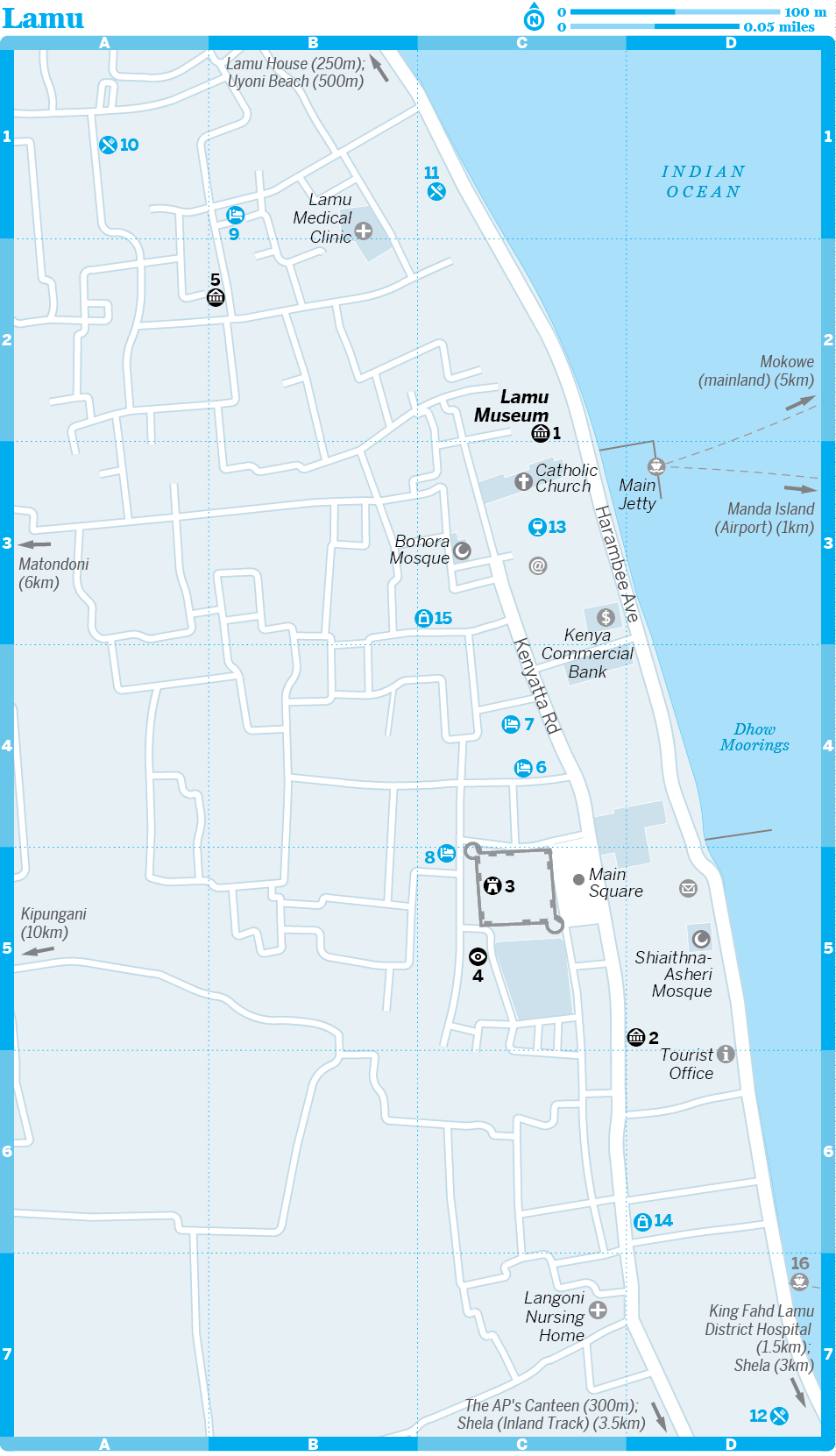
1Sights
Lamu is one of those places where the real attraction is just the overall feel of the place and there actually aren’t all that many ‘sights’ to tick off.
Lamu MuseumMUSEUM
(
MAP
GOOGLE MAP
; Harambee Ave, Waterfront; adult/child KSh500/250; h8am-6pm)
The best museum in town is housed in a grand Swahili warehouse on the waterfront. This is as good a gateway as you’ll get into Swahili culture and that of the archipelago in particular. Of note are the displays of traditional women’s dress – those who consider the head-to-toe bui-bui restrictive might be interested to see the shiraa, a tent-like garment (complete with wooden frame to be held over the head) that was once the respectable dress of local ladies. There are also exhibits dedicated to artefacts from Swahili ruins, the bric-a-brac of local tribes and the nautical heritage of the coast (including the mtepe, a traditional coir-sewn boat meant to resemble the Prophet Mohammed’s camel – hence the nickname, ‘camels of the sea’). Guides are available to show you around.
Lamu FortFORTRESS
( MAP GOOGLE MAP ; Main Sq)
This squat castle was built by the Sultan of Paté from 1810 and completed in 1823. From 1910 right up to 1984 it was used as a prison. It now houses the island’s library, which holds one of the best collections of Swahili poetry and Lamu reference work in Kenya. Entrance is free with a ticket to the Lamu Museum.
Lamu MarketMARKET
( MAP GOOGLE MAP ; opposite Lamu Fort)
Atmospheric and chaotic, this quintessential Lamu market is best visited early in the morning. Bargain for stinking fresh tuna and sailfish, wade through alleys teeming with stray cats, dogs and goats, and experience Lamu at its craziest. If you're sick of seafood, this is the place to find your five-a-day.
Swahili HouseMUSEUM
(
MAP
GOOGLE MAP
; adult/child KSh500/250; h8am-6pm)
This preserved Swahili house, tucked away to the side of Yumbe House hotel, is beautiful, but the entry fee is very hard to justify, especially as half the hotels in Lamu are as well preserved as this small house.
German Post Office MuseumMUSEUM
(
MAP
GOOGLE MAP
; Kenyatta Rd; adult/child KSh500/250; h8am-6pm)
In the late 1800s, before the British decided to nip German expansion into Tanganyika in the bud, the Germans regarded Lamu as an ideal base from which to exploit the interior. As part of their efforts, the German East Africa Company set up a post office, and the old building is now a museum exhibiting photographs and memorabilia from that fleeting period when Lamu had the chance of being spelt with an umlaut.
Lamu Walking Tour
Start Lamu main jetty
Finish Shiaithna-Asheri Mosque
Distance About 1km
Duration 45 minutes to one hour
The best, indeed only, way to see Lamu town is on foot. Few experiences compare with exploring the far back streets, where you can wander amid wafts of cardamom and carbolic and watch the town’s agile cats scaling the coral walls. There are so many wonderful Swahili houses that it’s pointless for us to recommend specific examples – keep your eyes open wherever you go, and don’t forget to look up.
Starting at the 1main jetty, head north past the 2Lamu Museum and along the waterfront until you reach the 3door-carving workshops.
From here head onto Kenyatta Rd, passing an original Swahili 4well, and into the alleys towards the 5Swahili House Museum. Once you’ve had your fill of domestic insights, take any route back towards the main street.
Once you’ve hit the main square and the 6fort, take a right to see the crumbled remains of the 14th-century 7Pwani Mosque, one of Lamu’s oldest buildings – an Arabic inscription is still visible on the wall. From here you can head round and browse the covered 8market, then negotiate your way towards the bright Saudi-funded 9Riyadha Mosque, the centre of Lamu’s religious scene.
Now you can take as long or as short a route as you like back to the waterfront. Stroll along the promenade, diverting for the aGerman Post Office Museum if you haven’t already seen it – the door is another amazing example of Swahili carving. If you’re feeling the pace, take a rest and shoot the breeze on the bbaraza ya wazee (‘old men’s bench’) outside the stucco minarets of the cShiaithna-Asheri Mosque.
Carrying on up Harambee Ave will bring you back to the main jetty.
zFestivals & Events
Maulid FestivalRELIGIOUS
(www.lamu.org/maulid-celebration.html)
The Maulid Festival celebrates the birth of the Prophet Mohammed. Its date shifts according to the Muslim calendar (December 2015). The festival has been celebrated on the island for over 100 years and much singing, dancing and general jollity takes place around this time. On the final day a procession heads down to the tomb of the man who started it all, Ali Habib Swaleh.
Lamu Cultural FestivalCULTURAL
Exact dates for this colourful carnival vary each year, but it often falls in November. Expect donkey and dhow races, Swahili poets and island dancing.
In September 2011 an English couple staying on the island of Kiwayu, north of Lamu, were attacked by Somali pirates/militants. One person died and one was kidnapped and taken to Somalia. It was widely thought that this was a one-off attack and that Lamu itself was not at risk. However, despite a massive beefing up of security, just over two weeks later another attack occurred. This time a French woman was kidnapped from her home on Manda Island and taken to Somalia (where she later died from a diabetic incident).
Following a series of armed attacks in Mombasa in mid-2014, the coastal town of Mpeketoni (25km from Lamu Town) was hit by what was at the time believed to be Al-Shabaab militants claiming revenge for the presence of Kenyan troops in Somalia and the killing of Muslims. Further analysis suggested that these attacks were likely perpetrated by Somali and Oromo residents in an attempt to deflect blame onto Al-Shabaab (using the group's flag as a guise) and claim the area as their ancestral home after Kenya's first President, Jomo Kenyatta settled ethnic Kikuyus on their land after independence.
Many countries advised against travel to Lamu in the wake of these attacks, resulting in void travel insurance policies and a drop in tourism that devastated local communities. A curfew was in place on Lamu at the time of research and we urge you to check the latest on the security situation before travelling. At the time of going to print there had been no further attacks and independent travellers were starting to return to these otherwise blessed isles.
4Sleeping
The alleyways of Lamu are absolutely rammed with places to stay and competition means that prices are often lower than in other parts of Kenya. There’s always scope for price negotiation, especially if you plan to stay for over a day or two. Touts will invariably try and accompany you to get commission; the best way to avoid this is to book at least one night in advance, so you know what you’ll be paying.
oNew Bahati LodgeGUESTHOUSE
(
MAP
GOOGLE MAP
; %0726732746; www.lamuguesthouse.com; d/tr KSh1400/2500)
This newly renovated budget house occupies prime position in Lamu's old town and pulls in plenty of budget travellers. The rooms are clean, fresh and spacious, but you'll probably spend most of your time in the loungey chill-out areas. The master bedroom at the top of the house has the best ocean view.
oBaitul Noor HouseBACKPACKERS
(
MAP
GOOGLE MAP
; %0725220271, 0723760296; www.lamubackpackers.com; dm/s/d KSh1000/1500/2500)
From the Arabic for 'house of light', this 16th-century town house is the stylish new backpackers on the block. The dorms are lovely and eco-friendly, featuring seven-foot beds, homemade soaps and solar reading lamps. Don't miss the stylish roof terrace and the downstairs restaurant, which does lobster suppers for lemonade pockets. Helpful staff can arrange all manner of excursions.
Yumbe HouseBOUTIQUE HOTEL
(
MAP
GOOGLE MAP
; %0726732746; www.lamuguesthouse.com; s/d KSh2500/3200)
This beautiful 17th-century house is made from coral, which is reason enough to stay here. Add spacious rooms decorated with pleasant Swahili accents, verandahs that are open to the stars and the breeze, and a ridiculously romantic top-floor suite. Top value for your shilling.
oSubira HouseGUESTHOUSE
(
MAP
GOOGLE MAP
; %0726916686; www.subirahouse.com; r KSh5000-8000)
This beautiful house features graceful arches and twin gardens with wells. The Swedish owners certainly know a thing or two about style, as did the Sultan of Zanzibar when he built the house 200 years ago. As well as seven stylish bedrooms, there are galleries in which to relax and serious eco-credentials. We rate the restaurant highly.
oLamu HouseBOUTIQUE HOTEL
(
GOOGLE MAP
; %0708073164, 0708279905; www.lamuhouse.com; Harambee Ave; r US$230-490)
In a town where every building wants to top the preservation stakes, Lamu House stands out. It looks like an old Swahili villa, but it feels like a stylish boutique hotel, blending the pale, breezy romance of the Greek islands into an African palace, with predictably awesome results. The excellent Moonlight restaurant serves fine Swahili cuisine.
A free boat service to Manda Island leaves from here every morning at 8am.
5Eating
Lamu’s fruit juices, which almost every restaurant sells, are worth drawing attention to. They’re good. They’re really, really good.
Many of Lamu's cheap places to eat close until after sunset during Ramadan.
oTehranKENYAN
( GOOGLE MAP ; Kenyatta Rd; mains from KSh100)
This very atmospheric but basic place doesn’t even have a sign, but it does serve dirt-cheap meals of fish, beans (the best is maharagwe ya chumvi – with coconut milk) and chapatis. It’s consistently packed with locals and is pretty much open all the time.
Bustani CaféCAFE
( MAP GOOGLE MAP ; meals KSh320-500)
This pretty garden cafe has tables set about a lily-bedecked pond. The small menu includes lots of healthy salads and various snack foods. It also contains a decent bookshop and an evening-only internet cafe (KSh240 per hour).
Olympic RestaurantAFRICAN
( MAP GOOGLE MAP ; Harambee Ave; mains KSh450-900)
The family that runs the Olympic makes you feel as if you’ve come home every time you enter, and their food, particularly the curries and biriyani, is excellent. There are few better ways to spend a Lamu night than with a cold mug of passionfruit juice and the noir-ish view of the docks you get here, at the ramshackle end of town.
oMwana Arafa Restaurant GardensSEAFOOD
( MAP GOOGLE MAP ; Harambee Ave; meals KSh350-1200)
Everyone loves Mwana Arafa. It has the perfect combination of garden seating and views over the dhows bobbing about under the moonlight. With barbecued giant prawns, grilled calamari, lobster or a seafood platter, we guess you’ll be eating the fruits of the sea tonight.
6Drinking & Nightlife
As a Muslim town, Lamu has few options for drinkers and local sensibilities should be respected. Full moon parties sometimes take place in season over on Manda Island.
Petley’s InnBAR
( MAP GOOGLE MAP ; Harambee Ave)
Right in front of the main jetty, Petley's seems to be the local watering hole for just about everyone. Expect almost anything, from good fun and merriment to enough hassle to speed you through the doors.
7Shopping
If you're into unusual fabrics, you can pick up bags made from the recycled cotton of dhow sails, often decorated with iconic Lamu images. Textile fans will also enjoy shopping for material sourced from Oman and Somalia. Head north along Kenyatta Rd from the direction of the fort and you'll find a scattering of places selling such wares, as well as some high-quality silversmiths. Perhaps the most charismatic among them is a chap called Slim, whose silversmith shop – with the original name of Slim Silversmith – sells beautiful rings created from ancient cuttings of coloured tiles.
Baraka GalleryARTS & CRAFTS
( MAP GOOGLE MAP ; Kenyatta Rd)
For upmarket Africana, Baraka Gallery has a fine selection, but stratospheric prices.
Black & White GalleryARTS & CRAFTS
( MAP GOOGLE MAP )
Spanish-run art shop with some beautiful tribal-inspired crafts and paintings.
Lamu Museum ShopBOOKS
( MAP GOOGLE MAP ; Harambee Ave)
Specialists in Lamu and Swahili cultural books.
8Information
Dangers & Annoyances
At the time of research, some governments were advising against travel to Lamu and the wider region.
When times are normal the biggest real issue are the beach boys. They’ll come at you the minute you step off the boat, offering drugs, tours and hotel bookings (the last can be useful if you’re disoriented).
Lamu has long been popular for its relaxed, tolerant atmosphere, but it does have somewhat conservative views as to what is acceptable behaviour. In 1999, a gay couple who planned a public wedding here had to be evacuated under police custody. Whatever your sexuality, it’s best to keep public displays of affection to a minimum and respect local attitudes to modesty.
Female travellers should note that most Lamurians hold strong religious and cultural values, and may be deeply offended by revealing clothing. There have been some isolated incidents of rape, which locals say were sparked by tourists refusing to cover up. That may outrage some Western ears, but the fact remains that you risk getting into hot water if you walk around in small shorts and low-cut tops. There are miles of deserted beaches on which you can walk around butt naked if you choose, but we urge you to respect cultural norms in built-up areas.
Internet Access
Medical Services
King Fahd Lamu District HospitalHOSPITAL
(%012-633075)
This government-run hospital is rundown but has competent medical staff.
Langoni Nursing HomeMEDICAL
(
GOOGLE MAP
; %012-633349; Kenyatta Rd;
h24hr)
Don't be put off by the name; this clinic offers GP services.
Money
Kenya Commercial BankBANK
(
GOOGLE MAP
; %012-633327; Harambee Ave)
The main bank on Lamu, with an ATM (Visa only).
Tourist Information
Tourist OfficeTOURIST INFORMATION
(
GOOGLE MAP
; %012-633132; lamu@tourism.go.ke; Harambee Ave;
h9am-1pm & 2-4pm)
A commercial tour and accommodation agency that also provides tourist information.
8Getting There & Away
Air
The airport at Lamu is on Manda Island, and the ferry across the channel to Lamu costs KSh150.
AirkenyaAIRLINE
(
MAP
GOOGLE MAP
; %042-633445; www.airkenya.com; Baraka House, Kenyatta Rd)
Daily afternoon flights between Lamu and Wilson Airport in Nairobi (US$195).
Fly540AIRLINE
(%042-632054; www.fly540.com)
Flies twice daily to Malindi (around US$45) and Nairobi (around US$170).
Bus
There are booking offices for several bus companies on Kenyatta Rd on Lamu. The going rate for a trip to Mombasa (8-9 hours) is KSh800 to KSh900; most buses leave between 7am and 8am, so you’ll need to be at the jetty at 6.30am to catch the boat to the mainland. Book early and be on time. Buses deliberately leave on the dot in order to resell the seats of latecoming passengers further up the line. The most reliable companies are Simba (%0707471110, 0707471111), Tahmeed (
%0724581015, 0724581004) and Tawakal (
%0705090122). Note that prices tend to increase by KSh100-200 during the high season.
At the time of research, armed guards were on every Lamu-bound bus from Mombasa. Matatus, as you'd imagine, have no such security assurances.
Coming from Mombasa to Lamu, buses will drop you at the mainland jetty at Mokowe. From there you can either catch the passenger ferry (KSh100, 30-40 mins) or a speedboat (KSh150, 10mins travel).
8Getting Around
Ferries between the airstrip on Manda Island and Lamu cost KSh150 and leave about half an hour before the flights leave (yes, in case you’re wondering, all the airline companies are aware of this and so that’s sufficient time).
Between Lamu village and Shela there are plenty of motorised dhows throughout the day until around sunset; these cost about KSh150 per person and leave when full.
There are also regular ferries between Lamu and Paté Island.
The Lamu archipelago has plenty to offer outside Lamu itself. The easiest to get to is Manda Island, just across the channel, where most visitors go on dhow trips for snorkelling and to visit the Takwa ruins. The tiny Manda Toto Island, on the other side of Manda, has perhaps the best reefs on the coast.
Further northeast, Paté Island was the main power centre in the region before Lamu came to prominence, but is rarely visited now, preserving an uncomplicated traditional lifestyle as much by necessity as by choice. A regular motor launch shuttles between the towns of Mtangawanda, Siyu, Faza and Kizingitini.
Calling all explorers! We dare you to challenge yourself against some of the most exciting wilderness in Africa. Step forward only if you’re able to withstand appalling roads, searing heat, clouds of dust torn up by relentless winds, primitive food and accommodation, vast distances and more than a hint of danger.
The rewards include memories of vast shattered lava deserts, camel herders walking their animals to lost oases, fog-shrouded mountains full of mysterious creatures, prehistoric islands crawling with massive reptiles and jokes shared with traditionally dressed warriors. Additional perks include camel trekking through piles of peachy dunes, elephant encounters in scrubby acacia woodlands and the chance to walk barefoot along the fabled shores of a sea of jade.
For most people this route means two things: the wildlife riches of the Samburu ecosystem or the road to the cultural riches of Ethiopia. But in between and beyond, this area has much more to offer. You can drink tea and track game with the Samburu people, climb mist-shrouded volcanoes in the desert, blaze trails in untrammelled mountains and get so far off the beaten track you’ll start to wonder whether you’re still on the same planet.
Isiolo is where anticipation and excitement first start to send your heart a-flutter. This vital pit stop on the long road north is a true frontier town, a place on the edge, torn between the cool, verdant highlands just to the south and the scorching badlands, home of nomads and explorers, to the north. On a more practical note it’s also the last place with decent facilities until Maralal or Marsabit.
One of the first things you’ll undoubtedly notice is the large Somali population (descendants of WWI veterans who settled here) and the striking faces of Boran, Samburu and Turkana people walking the streets. It’s this mix of people, cultures and religions that is the most interesting thing about Isiolo. Nowhere is this mixture better illustrated than in the hectic market.
Isiolo
4Sleeping
4Sleeping
oRange Land HotelCOTTAGES
(
GOOGLE MAP
; %0710114030; www.rangelandhotels.com; A2 Hwy; campsite per person KSh1000, s/d cottages KSh3000/4000;
p
W)
About 4km south of town, this is a nice option for those with their own set of wheels. The sunny campground has bickering weaver birds and busy rock hyraxes in abundance, as well as neat-and-tidy stone bungalows with hot showers. Many people come to laze around in the gardens at the weekend, but during the week it’s quiet.
Excellent meals are available and the house special is rabbit (KSh1200), a delicious rarity in Kenyan cuisine.
Moti Peal HotelHOTEL
(
MAP
GOOGLE MAP
; %064-52400; s/d KSh2500/3500;
W)
This smart place markets itself as the ‘Pearl of Isiolo’. This actually says more about the state of Isiolo than the quality of the hotel, but even so it's shockingly clean, well run and has friendly management.
The strong warrior traditions of northern Kenya’s nomadic peoples have led to security problems plaguing the region for years. With an influx of cheap guns from conflict zones surrounding Kenya, minor conflicts stemming from grazing rights and cattle rustling (formerly settled by compensation rather than violence) have quickly escalated into ongoing gun battles that the authorities struggle to contain.
While travellers, who rarely witness any intertribal conflict, may consider the issue exaggerated, the scale of the problem is enormous and growing. Over the past decade hundreds of Kenyans are thought to have been killed and tens of thousands displaced by inter-tribal conflicts. Fortunately security on the main routes in the north, and anywhere a tourist is likely to be, is generally good. Fighting around Moyale has increased somewhat since 2011, and in 2012 there was serious inter-tribal fighting in Moyale itself that eventually saw the Ethiopian military get involved. There have also been times when access to the Samburu National Reserve ( MAP GOOGLE MAP ; adult/child US$70/40, vehicle KSh1000) has been restricted and in 2011 a group of tourists were attacked on the Moyale to Isiolo road. In late 2014 convoys and armed guards were no longer used between Marich and Lodwar or between Isiolo and Moyale, on the Ethiopian border.
The remote northeastern region around Garsen, Wajir and Mandera is still unstable and you should avoid travelling there due to continuing conflicts. Likewise, a full-scale Kenyan military invasion of Somalia and renewed fighting in the region is a strong reason to stay well clear (the border is also closed).
Improvements or not, security in northern Kenya is a fluid entity. Travellers should seek local advice about the latest developments before visiting and never take unnecessary risks.
5Eating
There are numerous cheap eating establishments throughout the town, but in general the hotel restaurants tend to offer more variety as well as a more salubrious environment.
Northbound self-caterers should head to 101 Supermarket (
MAP
GOOGLE MAP
; h8am-6pm Mon-Sat) and the daily market near the mosque to purchase food and drink, as there’s very little available beyond here.
Bomen HotelKENYAN
(
MAP
GOOGLE MAP
; meals KSh400-650; h7am-11pm)
A rare place serving more than the local usuals, with fried tilapia, pepper steak, goulash and curries up for grabs.
8Information
Green Acres.com Cyber CafeINTERNET
(
GOOGLE MAP
; per hr KSh180; h8am-8pm)
The world eagerly awaits an email from you. Do it from here.
Having your own 4WD gives you flexibility but comes with its own challenges, thanks to wide-ranging road conditions. For starters, you’ll need a large 4WD with high ground clearance and a skid plate to protect the undercarriage.
Do not underestimate how bad the roads are up here – on three recent research trips we have twice snapped drive shafts clean in two, replaced more springs and tyres than we care to remember, destroyed three suspension systems and shattered two radiators (thank you to the two Samburu moran with spears who, during our latest research trip, fixed the radiator at 2am somewhere south of Marsabit using a bar of soap and some tea leaves!). Unsurprisingly many car rental companies will not allow their vehicles to be taken north of Samburu National Reserve. If you do come up here it’s sensible to take an experienced driver and, if possible, travel in convoy with another 4WD.
Isiolo long marked the northern terminus of the tarmac road system, but the Chinese have, or rather had, been busy road building here. A pristine tarmac road runs about halfway up toward Marsabit before reverting to a rutted mess that will shake the guts out of you and your vehicle just beyond Laisamis. Eventually the road will extend all the way to Moyale on the Ethiopia border, but due to political in-fighting no work has been done on it since at least 2011. There were rumours in late 2014 that work was about to commence again.
There’s regular public transport as far north as Kalokol and Lokichoggio on Turkana’s west side, but it’s more limited up the lake’s east side, only reaching Baragoi via Maralal or North Horr via Marsabit. Buses run from Isiolo to Moyale on the Ethiopian border via Marsabit.
A few organised safaris and overland trucks now go to Lake Turkana’s west, but most still stick to the lake’s east side. Gametracker Safaris runs weekly overland safaris to Lake Turkana that generally depart on Wednesdays and Fridays from Nairobi.
8Getting There & Away
A couple of bus companies serve Nairobi with most buses leaving between 5.30am and 6.30am (KSh500, 4½ hours) from the main road through town and also stopping at the matatu and bus stand just south of the market. Evening buses operated by Liban Buses (
MAP
GOOGLE MAP
; %0722244847; A2 Hwy) creep north to Marsabit (KSh700, five hours) at 4.30pm. Moyale Star Buses (
MAP
GOOGLE MAP
; A2 Hwy) head to Moyale (KSh1500, 10hrs) at 1.30pm via Marsabit (KSh700, five hours).
For Maralal take an early-morning matatu to Wamba (KSh330, 2½ hours), and then a Maralal-bound matatu (KSh500, 2½ hours) from there. Regular matatus leave from a chaotic stand around the market and also serve Archer’s Post (KSh130-150, 25 minutes), Meru (KSh150, 1½ hours) and Nanyuki (KSh250, 1¾ hours).
Blistered with termite skyscrapers, shot through with the muddy Ewaso Ngiro River and heaving with heavyweight animals, the three national reserves of Samburu, Buffalo Springs ( MAP GOOGLE MAP ; adult/child US$70/40, vehicle KSh1000) and Shaba ( GOOGLE MAP ; adult/child US$70/40, vehicle KSh1000) are not as famous as some others, but they have a beauty that is unsurpassed, as well as a population of creatures that occur in no other major Kenyan park. These include the blue-legged Somali ostrich, super-stripy Grevy’s zebras, unicorn-like beisa oryxes, ravishing reticulated giraffes and the gerenuk – a gazelle that dearly wishes to be a giraffe. Despite comprising just 300 sq km, the variety of vegetation and landscapes here is amazing. Shaba, with its great rocky kopjes (isolated hills), natural springs and doum palms, is the most physically beautiful, as well as the least visited (but it often has a lot less wildlife than the other two reserves). Meanwhile the open savannahs, scrub desert and verdant river foliage in Samburu and Buffalo Springs virtually guarantee close encounters with elephants and all the others.
Samburu & Buffalo Springs National Reserves
4Sleeping
To see some of Kenya’s most unique creatures in a compelling and beautiful desert landscape. Samburu is also one of the best places in the country to see elephants. Crowds of visitors are nonexistent.
There’s little rain in these parts so it’s possible to visit year-round, but between November and March animals congregate near the Ewaso Ngiro river.
Isiolo is the main gateway town. Conveniently, for the moment at least, Buffalo Springs, Shaba and Samburu entries are interchangeable, so you only pay once, even if you’re visiting all three in one day. You must buy your ticket at the gate to the park in which you’re staying. Petrol is available in Archer's Post.
You can camp in any of the reserves (but you mostly need to be self-sufficient). However, you'll still need a vehicle to get around. These can be hired by the half-day in Archer's Post.
4Sleeping & Eating
Samburu Simba LodgeLODGE
(
MAP
GOOGLE MAP
; %Nairobi 020-4444401; www.simbalodges.com; s/d full board US$495/575;
i
s)
It doesn't exactly blend harmoniously into the countryside, but this large lodge, with accommodation in big rooms scattered over several blocks, is ideal for those who prefer something other than canvas between them and the wildlife. It's one of the few options in Buffalo Springs.
Riverside CampTENTED CAMP
(Edwards Camp;
MAP
GOOGLE MAP
; %0721108032, 0721252737; per person KSh1500, per person full board KSh3500)
On the northern bank of the Ewaso Ngiro River, the scrappy (and hot) dark canvas safari tents here might not climb as luxuriously high as some of the big-boy lodges but, let’s face it, this is much more authentic Africa. Meals can be prepared on request. Vervet monkeys and baboons can be a menace, though. It's very close to the park headquarters.
Samburu Public CampsiteCAMPGROUND
( MAP GOOGLE MAP ; camping US$30)
The main public campsite is close to the park headquarters. It lacks even the most basic facilities and there are lots of baboons with light fingers. Arrange your stay through the park ticket office.
Elephant Watch CampTENTED CAMP
(
MAP
GOOGLE MAP
; %0733639630, Nairobi 020-8048602; www.elephantwatchsafaris.com; s/d all inclusive US$800/1440, plus service charge per person US$25;
hclosed Apr–10 May & Nov–10 Dec)
S
Undoubtedly the most unique and memorable place to stay in Samburu. Massive thatched roofs cling to crooked acacia branches and tower over cosy, palatial, eight-sided tents and large, grass-mat-clad terraces. Natural materials dominate the exteriors, bright textiles the interiors, and the bathrooms are stunning.
Elephant BedroomTENTED CAMP
(
MAP
GOOGLE MAP
; %Nairobi 020-4450035; www.atua-enkop.com; s/d all inclusive US$440/690;
s)
Twelve absolutely superb riverfront tents that are so luxurious even budding princesses will feel a little overwhelmed by the surroundings. Exactly how luxurious are we talking? Well, when was the last time you saw a tent that came with a private plunge pool?
oJoy’s CampTENTED CAMP
(%0730127000; www.joyscamp.com; s/d all inclusive from US$437/728;
W
s)
S
Once the home of Joy Adamson, of Born Free fame, this is now an outrageously luxurious camp in Shaba's remotest corner. The accommodation is in ‘tents’, but these tents aren't like others – they come with underfloor lighting, lots of stained glass and giant, walk-in rain showers.
In 1990, 15 women, who were allegedly raped by British military personnel who train in the area and then suffered further abuse from violent husbands, abandoned their homes and started the village of Umoja (meaning ‘unity’ in Kiswahili), just outside Archer’s Post. They hoped to survive together by producing and selling traditional Samburu jewellery to tourists. It proved rather successful and Umoja thrived, even opening a campsite a few years later. Boosted by its success, dozens more women left unhappy situations and now call the women-only village home.
At first, things weren’t quite perfect in this female paradise and the success of Umoja spawned jealousy and even reports of violence directed at Umoja from local men. Today, though, things have calmed down considerably and there are few such problems. Find out more about the village at www.umojawomen.net.
8Information
Buffalo Springs, Shaba and Samburu entry tickets are interchangeable for all three parks, so you only pay once, but can visit all three in one day.
8Getting There & Away
The vehicle-less can wrangle a 4WD and driver in Archer’s Post for about US$100 per half-day.
AAirkenya (www.airkenya.com) and Safarilink (www.flysafarilink.com) have frequent flights from Nairobi to Samburu, Kalama and Shaba.
The bridge between Samburu and Buffalo Springs has been collapsed for years, but Isiolo county's governor has promised it will be rebuilt soon. If it is still in pieces, and you want to visit both Samburu and Buffalo Springs, you'll need to make a long detour back to Archer's Post and the main A2 road, which can take up to three hours.
Climbing from the Korante Plain’s sands are the magnificent rusty bluffs and ridges of the Ndoto Mountains. Kept a virtual secret from the travelling world by their remote location, the Ndotos abound with hiking, climbing and bouldering potential. Mt Poi (2050m), which resembles the world’s largest bread loaf from some angles, is a technical climber’s dream, its sheer 800m north face begging to be bagged. If you’re fit and have a whole day to spare, it’s a great hike to the summit and the views are extraordinary.
The tiny village of Ngurunit is the best base for your adventures and is interesting in its own right, with captivating, traditionally dressed Samburu people living in simple, yet elegantly woven, grass huts.
Marsabit is a long way from anywhere. The road from Isiolo is now smooth tarmac for about half the distance but, even so, for hour after scorching hour you’ll pass a monotonous landscape of scrubby bush, where encounters with wildlife are common and elegant Samburu walk their herds of camels and goats. As the afternoon heats up, and your brain starts to cook, you’ll find the world around you sliding in and out of focus, as mirages flicker on the horizon. Then, as evening comes, one final mirage appears: a massive wall of forested mountains providing an unlikely home to mammoth tusked elephants. But this is no mirage, this is Marsabit.
4Sleeping & Eating
Water is a very scarce commodity in Marsabit and all the guesthouses have to truck it in. Use it sparingly.
Nomads Trail HotelHOTEL
(
GOOGLE MAP
; %0726560846, Nairobi 020-8004454; A2 Hwy; s/d old rooms KSh1800/2700, new rooms KSh3000/4500;
p
W)
The rooms here are prim and proper and all have attached bathrooms that come with – wait for it – real hot water from a real shower! Upstairs are some newer rooms that, for Marsabit, are shockingly posh.
JeyJey CentreHOTEL
(
GOOGLE MAP
; %0728808801/2; A2 Hwy; camping KSh300, s/d/tw with shared bathroom KSh600/1000/1500, d KSh1200;
p
W)
This mud-brick castle bedecked in flowers is something of a travellers’ centre and is always bursting with road-hardened souls. Basic rooms with mosquito nets surround a courtyard, and bathrooms (even shared ones) sport on-demand hot water. There’s also an unattractive campground.
Jirime Hotel & ResortHOTEL
(
GOOGLE MAP
; %0770834050; www.jirimehotel.com; A2 Hwy; camping KSh500, s/d KSh3000/5000;
p
W)
The smartest option in Marsabit is this new place, 2.5km north of town on the road to Moyale. It has little in the way of character but has big, tiled en-suite rooms, lots of peace and quiet, a decent in-house restaurant and pretty good wi-fi. Camping is also possible.
Five Steers HotelKENYAN
(
GOOGLE MAP
; A2 Hwy; meals KSh250-400; h8am-8pm)
With a wooden fenced-off terrace, this place is the height of Marsabit style. The ‘½ Federation’ meal (a bulging pile of rice, spaghetti, beef, vegetables and chapati) is filling and tasty. The owner is a good source of information on onward transport.
8Information
8Getting There & Away
Although improved security means convoys and armed guards are no longer being used to Moyale or Isiolo, it’s still wise to get the latest security and Ethiopian border information from locals and the police station before leaving town. As a rule, if buses and trucks travel in a convoy or take armed soldiers on board, you should too!
Moyale Raha Buses ( GOOGLE MAP ) connect Marsabit to Moyale daily at 5.30pm (KSh800, 6 hours). The bus picks up passengers outside the Jey Jey Centre. Heading south both Moyale Raha and Liban Buses ( GOOGLE MAP ) run buses to Isiolo (KSh700, six hours) at 6am (Liban Buses) and a flexible 11am (Moyale Raha Buses). Journey times will fall as the tarmac road grows. 'Buses' to North Horr via Kalacha leave at 5pm every other day and take at least 10 very hot, sandy hours to North Horr. Take note though that there's no reliable transport onward to the lake from North Horr.
Within the larger national reserve, this small park (adult/child US$25/15; h6.30am-6pm), nestled on Mt Marsabit’s upper slopes, is coated in thick forests and contains a wide variety of wildlife, including leopards, elephants (some with huge tusks) and buffaloes. The park forms a key point on an elephant migration route that extends as far as the slopes of Mt Kenya. The dense forest makes spotting wildlife very difficult, but fortunately help is at hand in the form of a couple of natural clearings with semi-permanent lakes where animal sightings are almost guaranteed.
In the increasingly common years when the rains fail, the park very quickly turns brown, parched and apparently lifeless. In more generous years the vegetation positively glows green, the lakes fill with water and animals seem to re-appear from nowhere. At the time of research (2014) the park was looking the best we've seen it in years and visiting it was a real treat.
If you're without transport it's possible to walk to the Marsabit Lodge with an armed ranger (per person KSh1500; organise this through the park office the day before if possible). With luck you'll have some exciting encounters with buffaloes and elephants.
4Sleeping & Eating
Lake Paradise Special CampsiteCAMPGROUND
( GOOGLE MAP ; camping adult US$35, plus set-up fee US$20)
Although there’s nothing except a dried-up lakebed and firewood, this picturesque site is the best place to camp in the park. Due to roaming buffaloes and elephants, a ranger must be present when you camp here.
Marsabit LodgeLODGE
(
GOOGLE MAP
; %Nairobi 020-2695468; www.marsabitlodge.com; s/tw KSh6500/8500)
If you don't mind the rather faded rooms, this basic lodge has a deliciously peaceful setting overlooking the lake occupying Gof Sokorte Dika. Expect friendly service and a chef who, no doubt in pleasure at actually having something to do, puts together great meals. Electricity is by generator in the evening only.
Journeying to a sea of jade shouldn’t be something that is easy to do and this route, the ultimate Kenyan adventure, is certainly not easy. But for the battering you’ll take you’ll be rewarded a thousand times over with memories of vibrant tribes, camel caravans running into a red sunset, mesmerising volcanic landscapes and, of course, the north’s greatest jewel – the Jade Sea, Lake Turkana.
Walking down Maralal’s dusty streets, you can imagine Clint Eastwood emerging from a bar and proclaiming the town not big enough for the two of you. With its swinging cowboy doors and camels tied up outside colourful wooden shopfronts, it’s impossible not to think that you’ve somehow been transported to the Wild West.
Maralal has gained an international reputation for its fantastically frenetic International Camel Derby and a visit over its duration is truly unforgettable. Less crazy, but almost as memorable, are the year-round camel safaris and treks that are offered here.
1Sights & Activities
Maralal National SanctuaryWILDLIFE RESERVE
F
This sanctuary, home to zebras, impalas, hyenas and others, once completely surrounded the town. Today it only covers a small patch of land around what's left of the Maralal Safari Lodge. With nowhere really to drive or walk on a safari, one of the only ways to take in the animals is with a cold beverage in hand at Maralal Safari Lodge’s bar. You may need to bring your own beer, though, as this place may be on its last legs.
Loroghi Hills CircuitTREKKING
The Loroghi Hills Circuit, which takes in one of Kenya’s most astounding vistas, Lesiolo, is a rewarding five-day (78km) trek. It's detailed in Lonely Planet’s Trekking in East Africa. It should be posible to organise a guide through Yare Camel Club and Camp. Somewhat shorter walks are possible by just strolling aimlessly around the high country and down the paths linking shambas (small plots) that surround the town.
Yare Camel Club & CampSAFARIS
(
GOOGLE MAP
; %0729322500)
Organises guides and camels for independent camel safaris in the region. Half-day camel hire is US$20, while an overnight trip with guides, camping equipment, food and cook costs US$120 per person.
Inaugurated by Yare Safaris in 1990, the annual Maralal International Camel Derby held in early August is one of the biggest events in Kenya, attracting riders and spectators from around the world. The races are open to anyone, and the extended after-parties at Yare Camel Club & Camp are notorious – you’re likely to bump into some genuine characters here.
The derby’s first race is for amateur camel riders. Pony up KSh1000 for your entry and another KSh3000 for your slobbering steed and get racing! It’s a butt-jarring 11km journey. Don’t even start feeling sorry for your backside – the professional riders cover 42km.
For further information contact Yare Camel Club & Camp in Maralal.
4Sleeping
Sunbird Guest HouseGUESTHOUSE
(
MAP
GOOGLE MAP
; %0720654567; s/d KSh1000/1200;
p)
The single rooms are starting to look a little old and damp but, by and large, this very friendly place has quiet, clean and comfortable rooms with nice linen, mosquito nets and hot water in the bathrooms. The courtyard has a sunny, garden vibe and there’s a pleasant restaurant serving healthy fried stuff.
Samburu Guest HouseHOTEL
(
MAP
GOOGLE MAP
; %0725363471; www.samburuguesthouse.com; s/d KSh800/2000;
p
W)
Large, outrageously pink cube of a building on the edge of town with spacious rooms that take the cleanliness award for Maralal. The design of the building, though, is such that noise echoes through the rooms.
Yare Camel Club & CampCAMPGROUND, CABINS
(
GOOGLE MAP
; %0729322500; camping KSh500, s/tw/tr US$23/38/55;
p
i)
This long-standing travellers' hangout, 3km south of town, has dreary and overpriced cabins, but it's a good spot for overlanders thanks to grassy lawns perfect for camping and a sociable bar.
5Eating
Unless you’ve got the ugali (a staple made from maize or cassava flour, or both) or nyama choma itch, few of your taste buds will be scratched here. That said, check out the restaurants of the Sunbird and Samburu Guest Houses. Stock up at the market or the Sunguia Supermarket if you’re heading north.
Coast DishesKENYAN
( MAP GOOGLE MAP ; mains KSh80-240)
'The neighbourhood will never be the same again,' the sign outside this place confidently reads. In fact the neighbourhood hasn't changed one jot in years, but even so this place, which is run by a couple from the sultry coast, does bring a flavour of other places to Maralal with coastal staples such as pilau, though made with goat rather than fish.
Pop Inn HotelKENYAN
(
MAP
GOOGLE MAP
; meals KSh120-200; h7am-8pm)
This zebra-striped building has decent Kenyan staples, but its claim to have the ‘best food south of the Sahara – and that's a fact’ might not be a 'fact' at all – south of the roundabout seems more realistic.
8Information
Kenya Commercial BankBANK
( GOOGLE MAP )
Behind the market, with an ATM (the last one going north), but it can be a bit stroppy when presented with foreign Visa cards.
8Getting There & Away
Matatus serve Nyahururu (KSh500, three to four hours), Rumuruti (KSh300-400, 2½ hours) and Wamba (KSh500, 3½ hours). For Nairobi you need to change in Nyahururu. Reaching Isiolo involves staying overnight in Wamba to catch the early-morning southbound matatu.
Access to the north has gotten a little easier since 2012, with the road out of Maralal, which used to be one of the worst in the country, being regraded (though it's still heavy going and self-drivers require a good 4WD with high clearance). There are buses too, which look like they're crossed with a tank, heading to Baragoi at around 11am every morning (KSh500). As there is still no regular transport north from there, it's more pleasant to wait in Maralal for something heading further north.
Waits for trucks to Loyangalani on the shore of Lake Turkana (KSh1000 to KSh1500, nine to 12 hours) might last from a few days to a week.
oWild FrontiersSAFARIS
(%satelitte phone 088216-43334103; www.wildfrontierskenya.com)
S
Days spent moving at the pace of a camel, and campfire nights under a star-spangled sky. A camel safari through the wild lands of northern Kenya will likely be the highlight of any trip to the country. One of the best-regarded camel safari operators is Wild Frontiers.
Safaris can be as tough or lazy as you want and while there's plenty of wildlife around, most of your animal sightings will, at best, be a fleeting glimpse of a fleeing animal. There will be lots of cultural interactions, though, as you pass by remote villages and herders with their livestock. The typical safari takes place in and around the magnificent Matthews and Ndoto mountains and lasts six nights, but much longer ones going all the way to Lake Turkana can be organised.
Wild Frontiers safaris help support the Milgis Trust (www.milgistrustkenya.com), which works with local communities to preserve the pastoral way of life and the wildlife of northern Kenya.
The long descent off the Loroghi Plateau towards Baragoi serves up some sweet vistas and for mile after gorgeous mile you’ll literally see nothing but tree-studded grasslands alive with wildlife. Reaching Baragoi is a bit of an anticlimax though, as the dusty, diminutive town is clearly outdone by its surroundings.
The Star Station Filling sells pricey petrol and the bougainvillea-dressed Morning Star Guest House (s/d with shared bathroom KSh300/600) provides for a night’s kip – though they don’t supply the peg you’ll need to place over your nose before entering the communal toilets.
Walking camel-train safaris (everything from bare bones to luxury) leave from the remote Desert Rose lodge (%Nairobi 020-3864831; www.desertrosekenya.com; s/d all inclusive US$735/1250;
s) just north of Baragoi.
8Getting There & Away
The dirt track from Maralal to Baragoi is very rocky in places, but massively better than it was in 2012. Even so, if there has been any rain it becomes treacherous. The drive takes a minimum of three hours.
The road between Baragoi and South Horr, the next town along, is in reasonable shape and consists of compacted sand and bumpy rocky sections. Almost 23km north of South Horr, when the valley opens to the northern plains, you’ll see massive Mt Kulal (2293m) in the distance and Devil’s Hand, a large rock outcrop resembling a fist, to your immediate right. Just north is the eastern turn-off to Marsabit via Kargi, so if you’re heading for Turkana keep left. If you get mixed up, just remember that Mt Kulal on your right is good and that Mt Kulal on your left is very, very bad (unless, of course, you’re heading to Marsabit!).
Further north, the scrub desert scatters and you’ll be greeted by vast volcanic armies of shimmering bowling-ball-sized boulders, cinder cones and reddish-purple hues – Mt Kulal’s shattered lava fields. If this arresting and barren Martian landscape doesn’t take your breath away, the first sight of the sparkling Jade Sea a few kilometres north certainly will.
As you descend to the lake, South Island stands proudly before you, while Teleki Volcano’s geometrically perfect cone lurks on Turkana’s southern shore. Before you jump in the water, remember that Turkana has the world’s largest crocodile population.
Standing in utter contrast to the dour desert shades surrounding it, tiny Loyangalani assaults all your senses in one crazy explosion of clashing colours, feather headdresses and blood-red robes. Overlooking Lake Turkana and surrounded by small ridges of pillow lava (evidence that this area used to be underwater), the sandy streets of this one-camel town are a meeting point of the great northern tribes: Turkana and Samburu, Gabbra and El Molo. It’s one of the most exotic corners of Kenya and a fitting reward after the hard journey here.
1Sights & Activities
The El Molo tribe, which is one of Africa’s smallest, lives on the lake shore just north of Loyangalani in the villages of Layeni and Komote. Although outwardly similar to the Turkana, the El Molo are linguistically linked to the Somali and Rendille people. Unfortunately, the last speaker of their traditional language died before the turn of the millennium. Visiting their villages is something of a circus and don't expect to see many people traditionally dressed.
South Island National ParkNATIONAL PARK
(adult/child US$25/15)
Designated a World Heritage site by Unesco in 1997, this 39-sq-km purplish volcanic island is completely barren and uninhabited, apart from large populations of crocodiles, venomous snakes and feral goats. Spending the night at a special campsite (US$35) makes for an even eerier trip.
Mt KulalMOUNTAIN
Mt Kulal (2293m) dominates Lake Turkana’s eastern horizon and its forested volcanic flanks offer some serious hiking possibilities. This fertile lost world in the middle of the desert is home to some unique creatures, including the Mt Kulal chameleon, a beautiful lizard first recorded in only 2003.
Held in mid-June, the Lake Turkana Festival is a jamboree of all that is colourful with the tribes of northern Kenya. Originally organised by the German embassy it was taken on by the government in 2014 and word is was far less organised than in previous years… Even so if you want to see people in their tribal best there's no better time to be in town.
4Sleeping & Eating
Let’s face it: you came north for adventure, not comfort.
Malabo ResortBANDA
(%0724705800; resortmalabo@yahoo.com; camping KSh2000, huts from KSh2000, bandas KSh3000-4000;
p)
The newest, and best, place to stay in Loyangalani is a few hundred metres north of the village and has slight lake views. There's a range of decent bandas with arty wooden beds and attached bathrooms, or there are thatched huts based on a traditional Turkana design. The bar-restaurant area is a good place to hang out.
Cold Drink HotelKENYAN
(meals KSh100-150; h7am-8pm)
Not just cold drinks but also, according to locals, the finest eating experience in all of Turkana country, which sadly might actually be true.
8Getting There & Away
Trucks loaded with fish (and soon-to-be-smelly passengers) leave Loyangalani for Maralal (around KSh1000, nine to 12 hours) around once or twice a week at best. Trucks heading in any other direction are even rarer.
If you’re travelling in your own vehicle, you have two options to reach Marsabit: continue northeast from Loyangalani across the dark stones of the Chalbi Desert towards North Horr, or head 67km south towards South Horr and take the eastern turn-off via Kargi. The 270km Chalbi route (10 to 12 hours) is hard in the dry season and impossible after rain. The 241km southern route (six to seven hours) via the Karoli Desert and Kargi is composed of compacted sands and is marginally less difficult in the rainy season.
A Unesco World Heritage site and probably Kenya’s most remote national park, Sibiloi (www.sibiloi.com; adult/child US$25/15) is located up the eastern shore of Lake Turkana and covers 1570 sq km. It was here that Dr Richard Leakey discovered the skull of a Homo habilis believed to be 2.5 million years old, and where others have unearthed evidence of Homo erectus. Despite the area’s fascinating prehistory, fossil sites and wonderful arid ecosystem, the difficulties involved in getting this far north tend to discourage visitors, which is a real shame. It seems slightly ironic that the so-called ‘Cradle of Mankind’ is now almost entirely unpopulated.
The National Museums of Kenya (NMK) maintain a small museum and Koobi Fora (www.kfrp.com), a research base. It’s usually possible to sleep in one of the base’s bandas (per person KSh1000) or to pitch a tent in one of the campsites (camping per person KSh500).
Contact both the staff of the Loyangalani Desert Museum, the KWS (kws@kws.org) and NMK (NMK; www.museums.or.ke) before venturing in this direction.
In the dry season it’s a tricky seven-hour drive north from Loyangalani to Sibiloi. You will need a guide from either KWS or the Loyangalani Desert Museum. Hiring a jeep in Loyangalani will work out at around KSh40,000 per day. It’s also possible to hire a boat (KSh30,000 to KSh40,000 return with an overnight stop) from Fergusons Gulf on the western side of the lake.
Despite boasting some of northern Kenya’s greatest attributes, such as copious kilometres of Jade Sea shoreline, striking volcanic landscapes, ample wildlife and vivid Turkana tribes, this remote corner of the country sees relatively few visitors. With fairly reliable public transport this is definitely the easier side of the lake in which to grab a taste of the northern badlands.
Bursting from the depths of Lake Turkana and home to thousands of living dinosaurs is the Jurassic world of Central Island Volcano, last seen belching molten sulphur and steam just over three decades ago. It is one of the most otherworldly places in Kenya. Quiet today, its stormy volcanic history is told by the numerous craters scarring its weathered facade. Several craters have coalesced to form two sizeable lakes, one of which is home to thousands of fish that occur nowhere else.
Both a national park (adult/child US$20/10) and Unesco World Heritage site, Central Island is an intriguing place to visit. Budding Crocodile Dundee types will love the 14,000 or so Nile crocodiles, some of which are massive in proportion, who flock here at certain times of year (May is the most crocodile-friendly month, but there are some crocs here year-round). The most northerly crater lake, which is saline, attracts blushing pink flocks of flamingos.
Camping (US$35) is possible and, unlike South Island National Park, there are trees to tie your tent to. But there’s no water or any other facilities, so come prepared.
Hiring a boat from Ferguson’s Gulf is the only option to get here. Organising one through KWS (who are comically disorganised) will set you back a hefty KSh18,000. Organising one through the locals down by the boat landing strip is likely to start at KSh15,000 and drop to KSh10,000. Don’t ever think about being cheap and taking a sailboat. The 10km trip and sudden squalls that terrorise the lake’s waters aren’t to be taken lightly.
The spectacular descent from Marich Pass through the lush, cultivated Cherangani Hills leads to arid surroundings, with sisal plants, cactus trees and acacias lining both the road and the chocolate-brown Morun River. Just north, the minuscule village of Marich marks your entrance into northern Kenya.
2Activities
Mt SekerrTREKKING
Although the northern plains may beckon, it’s worth heading into the hills for some eye-popping and leg-loving hiking action. Mt Sekerr (3326m) is a few kilometres northwest of Marich and can be climbed comfortably in a three-day round trip via the agricultural plots of the Pokot tribe, passing through forest and open moors.
4Sleeping
Marich Pass Field Studies CentreCAMPGROUND, BANDA
(www.gg.rhul.ac.uk/MarichPass; camping KSh360, dm KSh420, s/tw KSh1450/1950, with shared bathroom KSh900/1240)
Just north of Marich village, this is essentially a residential facility for visiting student groups, but it also makes a great base for independent travellers. The centre occupies a beautiful site alongside the misty Morun River and is surrounded by dense bush and woodland. Facilities include a secure campground as well as a tatty dorm and simple, comfortable bandas.
8Getting There & Away
The road from Kitale via Makutano is the scenic A1 Hwy, which is often described as ‘Kenya’s most spectacular tarmac road’. The buses plying the A1 between Kitale and Lodwar can drop you anywhere along the route. You may be asked to pay the full fare to Lodwar (KSh1500), but a smile and some patient negotiating should reduce the cost.
Between Marich and Lokichar the A1 is a bumpy mess of corrugated dirt and lonely islands of tarmac. The first 40km north of Lokichar is better, but you’ll still spend more time on the shoulder than on the road. The opposite is true for the remaining 60km to Lodwar, where patches outnumber potholes and driving is straightforward.
The security situation is in a constant state of flux in this area. In late 2014 convoys were not required, but in the recent past there have been numerous incidents of cattle rustling as well as tribal clashes. These problems have been most prevalent in the area between Marich and Lokichar.
Besides Lokichoggio near the South Sudan border, Lodwar is the only town of any size in the northwest. Volcanic hills skirted by traditional Turkana dwellings sit north of town and make for fine sunrise spots. If you’re visiting Lake Turkana, you’ll find it convenient to stay here for at least one night.
4Sleeping
Nawoitorong Guest HouseHOTEL
(%0704911947; camping KSh300, s/tw with shared bathroom KSh800/1500, cottages KSh1400-2000;
p)
Built entirely out of local materials and run by a local women’s group, Nawoitorong is a solid budget option and the only one for campers. Thatched roofs alleviate the need for fans and all rooms have mosquito nets.
Ceamo Prestige LodgeHOTEL
(%0721555565; www.ceamolodge.com; s/d KSh6500/7500;
p
a
W)
A short way out of town, this new place is also Lodwar's flashest place to stay, with large, cool, quiet, tiled rooms in a bungalow setting. It might be Lodwar's finest but it's still very overpriced.
5Eating
Nawoitorong Guest HouseKENYAN
(meals KSh250-350; h7am-8pm)
Burgers and toasted sandwiches join local curries and various meaty fries on the menu. It offers the most pleasant dining experience in the region, but give it time – lots of it – to prepare dinner!
Salama HotelKENYAN
(meals KSh80-150; h6am-9pm)
The most popular place in the town centre. The culinary highlight of the Salama has to be its giant bowl of pilau (KSh100). There’s always a crowd of people here waiting for buses to depart.
8Information
Kenya Commercial Bank
Has an ATM and changes cash and travellers cheques.
8Getting There & Away
AFly540 (www.fly540.com) runs frequent flights from Nairobi to Lodwar and from Eldoret for around US$150.
AHappy Safaris Buses operates along the route to Kitale (KSh1000, 8½ hours) with departures at 6am from close to the Salama Hotel. Erratic matatus serve Kalokol (KSh500, one hour). There's also a matatu to Eliye Springs (KSh300; 1½ hours).
Spring water percolates out of crumbling bluffs and oodles of palms bring a taste of the tropics to the remote sandy shores of Lake Turkana. Down on the slippery shore children play in the lake’s warm waters, while Central Island lurks magically on the distant horizon.
Eliye Springs is the best place to get a taste of the lake's western shore.
8Getting There & Away
The turn-off for Eliye Springs is signposted a short way along the Lodwar–Kalokol road. The gravel is easy to follow until it suddenly peters out and you’re faced with a fork in the road – stay left.
If you don’t have your own vehicle, you can usually arrange a car and driver in Lodwar for about KSh5000 including waiting time. There are also very occasional matatus for KSh300.
The early history of Kenya, from prehistory up until independence, is covered in the History chapter.
Kenya was Great Britain's East African heartland and the battle for independence was always going to be one of Africa's more bitter struggles for freedom.
Despite plenty of overt pressure on Kenya’s colonial authorities, the real independence movement was underground. Tribal groups of Kikuyu, Maasai and Luo took secret oaths, which bound participants to kill Europeans and their African collaborators. The most famous of these movements was Mau Mau, formed in 1952 by disenchanted Kikuyu people, which aimed to drive the white settlers from Kenya forever.
The first blow was struck early with the killing of a white farmer’s entire herd of cattle, followed a few weeks later by the massacre of 21 Kikuyu loyal to the colonial government. The Mau Mau rebellion had started. Within a month, Jomo Kenyatta and several other Kenyan African Movement (KAU) leaders were jailed on spurious evidence, charged with ‘masterminding’ the plot. The various Mau Mau sects came together under the umbrella of the Kenya Land Freedom Army, led by Dedan Kimathi, and staged frequent attacks against white farms and government outposts. By the time the rebels were defeated in 1956, the death toll stood at more than 13,500 Africans (guerrillas, civilians and troops) and just more than 100 Europeans.
Upon his release in 1959 Kenyatta resumed his campaign for independence. Soon even white Kenyans began to feel the winds of change, and in 1960 the British government officially announced their plan to transfer power to a democratically elected African government. Independence was scheduled for December 1963, accompanied by grants and loans of US$100 million to enable the Kenyan assembly to buy out European farmers in the highlands and restore the land to the tribes.
With independence scheduled for 1963, the political handover began in earnest in 1962, with the centralist Kenya African National Union (KANU) and the federalist Kenya African Democratic Union (KADU) forming a coalition government.
The run-up to independence was surprisingly smooth, although the redistribution of land wasn’t a great success; Kenyans regarded it as too little, too late, while white farmers feared the trickle would become a flood. The immediate effect was to cause a significant decline in agricultural production, from which Kenya has never fully recovered.
The coalition government was abandoned after the first elections in May 1963 and Kikuyu leader, Jomo Kenyatta (formerly of the KANU), became Kenya’s first president on 12 December, ruling until his death in 1978. Under Kenyatta’s presidency, Kenya developed into one of Africa’s most stable and prosperous nations.
While Kenyatta is still seen as one of the few success stories of Britain’s withdrawal from empire, he wasn’t without his faults. Biggest among these were his excessive bias in favour of his own tribe and escalating paranoia about dissent. Corruption soon became a problem at all levels of the power structure and the political arena contracted.
Kenyatta was succeeded in 1978 by his vice-president, Daniel arap Moi. A Kalenjin, Moi was regarded by establishment power brokers as a suitable frontman for their interests, as his tribe was relatively small and in thrall to the Kikuyu. Moi went on to become one of the most enduring ‘Big Men’ in Africa, ruling in virtual autocracy for nearly 25 years.
On assumption of power, Moi sought to consolidate his regime by marginalising those who had campaigned to stop him from succeeding Kenyatta. Lacking a capital base of his own, and faced with shrinking economic opportunities, Moi resorted to the politics of exclusion. He reconfigured the financial, legal, political and administrative institutions. For instance, a constitutional amendment in 1982 made Kenya a de jure one-party state, while another in 1986 removed the security of tenure for the attorney-general, comptroller, auditor general and High Court judges, making all these positions personally beholden to the president. These developments had the effect of transforming Kenya from an ‘imperial state’ under Kenyatta to a ‘personal state’ under Moi.
By the late 1980s, most Kenyans had had enough. Following the widely contested 1988 elections, things came to a head on 7 July 1990 when the military and police raided an opposition demonstration in Nairobi, killing 20 and arresting politicians, human-rights activists and journalists. The rally, known thereafter as Saba Saba (‘seven seven’ in Swahili), was a pivotal event in the push for a multiparty Kenya. The resulting pressure led to a change in the constitution that allowed opposition parties to register for the first time.
Faced with a foreign debt of nearly US$9 billion and blanket suspension of foreign aid, Moi was pressured into holding flawed multiparty elections in early 1992. To make matters worse, about 2000 people were killed during tribal clashes in the Rift Valley. Moi was overwhelmingly re-elected.
The 1997 election, too, was accompanied by violence and rioting. European and North American tour companies cancelled their bookings and around 60,000 Kenyans lost their jobs. Moi was able to set himself up as peacemaker, calming the warring factions and gaining 50.4% of the seats for KANU. After the elections, KANU was forced to bow to mounting pressure and initiate some changes: some Draconian colonial laws were repealed, as well as the requirement for licences to hold political rallies.
But Kenya was about to enter a difficult period. On 7 August 1998, Islamic extremists bombed the US embassies in Nairobi and Dar es Salaam in Tanzania, killing more than 200 people and bringing al-Qaeda and Osama bin Laden to international attention for the first time. The effect on the Kenyan economy was devastating. It would take four years to rebuild the shattered tourism industry.
Having been beaten twice in the 1992 and 1997 elections, 12 opposition groups united to form the National Alliance Rainbow Coalition (NARC). With Moi’s presidency due to end in 2002, many feared that he would alter the constitution again to retain his position. This time, though, he announced his intention to retire.
Moi put his weight firmly behind Uhuru Kenyatta, the son of Jomo Kenyatta, as his successor, but the support garnered by NARC ensured a resounding victory for the party, with 62% of the vote. Mwai Kibaki was inaugurated as Kenya’s third president on 30 December 2002.
When Kibaki assumed office in January 2003, donors were highly supportive of the new government. During its honeymoon period, the Kibaki administration won praise for a number of policy initiatives, especially a crackdown on corruption. In 2003-04, donors contributed billions of dollars to the fight against corruption, including support for the office of a newly appointed anticorruption ‘czar’, and the International Monetary Fund resumed lending in November 2003.
Despite initially positive signs, it became clear by mid-2004 that large-scale corruption was still a considerable problem in Kenya. Western diplomats alleged that corruption had cost the treasury US$1 billion since Kibaki took office. In February 2005, the British High Commissioner Sir Edward Clay denounced the ‘massive looting’ of state resources by senior government politicians, including sitting cabinet ministers. Within days, Kibaki’s anticorruption ‘czar’, John Githongo, resigned and went into exile amid rumours of death threats related to his investigation of high-level politicians. With Githongo’s release of a damning detailed dossier on corruption in the Kibaki regime in February 2006, Kibaki was forced to relieve three ministers of their cabinet positions.
But it hasn’t all been bad news. The Kibaki government has succeeded in making primary and secondary education more accessible for ordinary Kenyans, while state control over the economy has been loosened.
On 27 December 2007, Kenya held presidential, parliamentary and local elections. While the parliamentary and local government elections were largely considered credible, the presidential elections were marred by serious irregularities, reported by both Kenyan and international election monitors, and by independent nongovernmental observers. Nonetheless, the Electoral Commission declared Mwai Kibaki the winner, triggering a wave of violence across the country. The Rift Valley, Western Highlands, Nyanza Province and Mombasa – areas afflicted by years of political machination, previous election violence and large-scale displacement – exploded in ugly tribal confrontations. The violence left around 1300 people dead and over 600,000 people homeless. Fearing for the stability of the most stable linchpin of East Africa, former UN Secretary-General Kofi Annan and a panel of ‘Eminent African Persons’ flew to Kenya to mediate talks. A power-sharing agreement was finally signed on 28 February 2008 between President Kibaki and Raila Odinga, the leader of the ODM opposition. The coalition provided for the establishment of a prime ministerial position (to be filled by Raila Odinga) as well as a division of cabinet posts according to the parties’ representation in parliament.
Despite some difficult moments, the fragile coalition government has stood the test of time, thereby going some way towards reassuring Kenyans and the international community. The government has also begun the complex (and long-overdue) task of long-term reform. Arguably its most important success has been the 2010 constitution, which was passed in a referendum by 67% of Kenya’s voters. Among the key elements of this new constitution are the devolution of powers to Kenya’s regions, the introduction of a bill of rights and the separation of judicial, executive and legislative powers.
It may seem a strange question to ask of a country that has proved to be one of Africa's most stable, but one of the hottest topics of conversation among ordinary Kenyans is this: can Kenya hold together? Kenyans were badly scarred by the post-election violence in 2007. So when Uhuru Kenyatta scraped over the line in the 2013 presidential elections amid allegations of electoral irregularities, the country, and the world, held their breaths. But somehow, a threshold was passed and the country held together – again. Had Kenya's political leaders grown in maturity sufficiently to recognise the dangers of escalating tensions? Or did they decide to bide their time for some future battle? At the time of writing, the answer remains unanswered.
But the fallout from the 2007 elections continues. In March 2011, the ICC indicted six prominent Kenyans, including presidential candidate Uhuru Kenyatta and former government minister William Ruto, for crimes against humanity allegedly committed during the violence that followed the disputed 2007 elections. Kenyan politicians soon began lining up to accuse the ICC and the Western governments who supported it of colonial attitudes and for interfering in Kenya's internal affairs. So successful was this argument that the ICC indictment of Kenyatta is widely credited with helping him to win the 2013 presidential election. In one of the more bizarre twists, Kenyatta's co-accused and former enemy at the 2007 elections, William Ruto, became Kenya's vice-president.
In October 2011, for the first time in its independent history, Kenya went to war. In response to attacks allegedly carried out by al-Shabaab, an al-Qaeda-affiliated Somali group, Kenya’s military launched a large-scale invasion of Somalia, claiming that it was acting in self-defence; most Western governments agreed, and the mission later came under the banner of the African Union. Kenya has played a high price for its involvement in Somalia. The attack by al-Shabab operatives on the West Gate Shopping Mall on 21 September 2013 left 67 people dead and placed enormous strain on Kenya’s relations with its large Somali population. Further attacks in the Nairobi suburb of Eastleigh in 2013, and on the area around Mpeketoni (close to Lamu) in June 2014 only heightened the sense of a nation under siege and unsure how to combat the threat. Quite apart from its impact upon Kenya's tourist industry, the episode served as a reminder that Kenya’s future as a multicultural, multi-faith state gets more complicated with each passing year.
Traditional cultures are what hold Kenya together. Respect for one’s elders, firmly held religious beliefs, traditional gender roles and the tradition of ujamaa (familyhood) create a well-defined social structure with stiff moral mores at its core. Extended family provides a further layer of support, while historically, the majority of Kenyans were either farmers or cattle herders with family clans based in small interconnected villages. Even today, as traditional rural life gives way to a frenetic urban pace, this strong sense of community remains.
Kenya is home to over 40 tribal groups. Although most tribal groups have coexisted quite peacefully since independence, the ethnocentric bias of government and civil service appointments has led to escalating unrest and disaffection. During the hotly contested elections of 1992, 1997 and 2007, clashes between two major tribes, the Kikuyu and Luo, bolstered by allegiances with other smaller tribes like the Kalenjin, resulted in death and mass displacement.
Some analysts point out that election violence and ethnic tensions have more to do with economic inequality than with tribalism – they insist that there are only two tribes in Kenya: the rich and the poor.
As a result of intense missionary activity, the majority of Kenyans outside the coastal and eastern provinces are Christians (including some home-grown African Christian groups that do not owe any allegiance to the major Western groups). Hard-core evangelism has made some significant inroads and many TV-style groups from the US have a strong following.
In the country’s east, the majority of Kenyans are Sunni Muslims. They make up about 11% of the population.
With its diversity of indigenous languages and culture, Kenya has a rich and exciting music scene. Influences, most notably from the nearby Democratic Republic of Congo and Tanzania, have helped to diversify the sounds. More recently reggae and hip hop have permeated the pop scene.
The live-music scene in Nairobi is excellent – a variety of clubs cater for traditional and contemporary musical tastes, while the Blankets & Wine phenomenon has fast become a mainstay of the capital's live-music program. Beyond Nairobi, take what you can get.
Benga is the contemporary dance music of Kenya. It refers to the dominant style of Luo pop music, which originated in western Kenya, and spread throughout the country in the 1960s being taken up by Akamba and Kikuyu musicians. The music is characterised by clear electric guitar licks and a bounding bass rhythm. Contemporary Kikuyu music often borrows from benga.
Taarab, the music of the East African coast, originally only played at Swahili weddings and other special occasions, has been given a new lease of life by coastal pop singer Malika.
Popular bands today are heavily influenced by benga, soukous and also Western music, with lyrics generally in Kiswahili. These include bands such as Them Mushrooms (now reinvented as Uyoya) and Safari Sound. For upbeat dance tunes, Ogopa DJs, Nameless, Redsan and Deux Vultures are popular acts.
Ngũgĩ wa Thiong’o (b 1938), Kenya’s best-known writer, is uncompromisingly radical, and his harrowing criticism of the neocolonialist politics of the Kenyan establishment landed him in jail for a year (described in his Detained: A Prison Writer’s Diary), lost him his job at Nairobi University and forced him into exile. His works include Petals of Blood, Matigari, The River Between, A Grain of Wheat, Devil on the Cross and Wizard of the Crow, which was short-listed for the 2007 Commonwealth Writers’ Prize. His latest works are memoirs: Dreams in a Time of War (2010) and In the House of the Interpreter (2012). All his works offer insightful portraits of Kenyan life and will give you an understanding of the daily concerns of modern Kenyans. Ngũgĩ has also written extensively in his native language, Gikuyu.
Another important Kenyan writer is Meja Mwangi, who sticks more to social issues and urban dislocation but has a mischievous sense of humour, while Binyavanga Wainaina is one of Kenya’s rising stars. Highly regarded female writers include Grace Ogot, Margaret Atieno Ogola, Marjorie Magoye and Hilary Ngweno.
To stay up to date with the contemporary scene, look out for Kwani? (kwani.org), Kenya’s first literary journal, established by Wainaina in 2003. It hosts an annual literary festival that attracts a growing number of international names.
Swahili culture has produced one of the most distinctive architectures in Africa, if not the world. Once considered a stepchild of Arabic building styles, Swahili architecture, while owing some of its aesthetic to the Middle East, is more accurately a reflection of African design partly influenced by the Arab (and Persian, Indian and even Mediterranean) world.
One of the most important concepts of Swahili space is marking the line between the public and private while also occasionally blurring those borders. So, for example, you’ll see Lamu stoops that exist both in the pubic arena of the street yet serve as a pathway into the private realm of the home. The use of stoops as a place for conversation further blends these inner and outer worlds. Inside the home, the emphasis is on creating an airy, natural interior that contrasts with the exterior constricting network of narrow streets. The use of open space also facilitates breezes that serve as natural air-conditioning.
You will find large courtyards, day beds placed on balconies and porches that all provide a sense of horizon within a town where the streets can only accommodate a single donkey. Other elements include: dakas (verandahs), which again sit in the transitional zone between the street and home and also provide open areas; vidaka, wall niches that either contain a small decorative curio or serve a decorative purpose in their own right; and mambrui (pillars), which are used extensively in Swahili mosques.
Kenya straddles the equator and covers an area of some 583,000 sq km, including around 13,600 sq km of Lake Victoria. It is bordered to the north by the arid bushlands of Ethiopia and Sudan, to the east by the Indian Ocean and the deserts of Somalia, to the west by Uganda and Lake Victoria, and to the south by Tanzania.
Kenya is dominated by the Rift Valley, a vast range of valleys that follows a 5500km‑long crack in the earth’s crust. The Rift’s path through Kenya can be traced through Lake Turkana, the Cherangani Hills and Lakes Baringo, Bogoria, Nakuru, Elmenteita, Naivasha and Magadi. Within the Rift are numerous ‘swells’ (raised escarpments) and ‘troughs’ (deep valleys, often containing lakes), and there are some huge volcanoes, including Mt Kenya, Mt Elgon and Mt Kilimanjaro (across the border in Tanzania).
The African savannah covers an estimated two-thirds of the African land mass and owes its existence to the Rift Valley when volcanic lava and ash rained down upon the lands surrounding the Rift's volcanoes, covering the landscape in fertile but shallow soils. Grasses flourished as they needed little depth for their roots to grow. The perfectly adapted acacia aside, however, no other plants were able to colonise the savannah, their roots were starved of space and nourishment. In Kenya, the most famous sweeps of savannah are found in the country’s west (particularly in the Masai Mara National Reserve) and south.
Along the coast of East Africa, warm currents in the Indian Ocean provide perfect conditions for coral growth, resulting in beautiful underwater coral reefs. In contrast, much of northern Kenya is extremely arid, with rainfall of less than 100mm a year. A number of contiguous deserts occupy the territory between Lake Turkana’s eastern shore and the Ethiopian and Somali borders.
The main rivers in Kenya are the Athi/Galana River, which empties into the Indian Ocean near Malindi, and the Tana River, which hits the coast midway between Malindi and Lamu. Aside from Lake Victoria, Kenya has numerous small volcanic lakes and mighty Lake Turkana, which straddles the Ethiopian border.
Kenya is home to all of the charismatic mega-fauna that draw so many visitors to Africa and the daily battle between predators and prey brings so much personality to the Kenyan wilds. The ‘Big Five’ – lion, buffalo, elephant, leopard and rhino – are relatively easy to spot in a number of places. The birdlife here is equally diverse – Kenya is home to over 1100 species with millions of migratory birds arriving or passing through the country from November to October.
Many of Kenya’s major predators and herbivores have become endangered because of the continuous destruction of their natural habitat and merciless poaching for ivory, skins, horn and bush meat.
The black rhino is probably Kenya’s most endangered large mammal. It is also often described as Kenya's indigenous rhino – historically, the white rhino was not found in Kenya. Pursued by heavily armed gangs, the black rhino’s numbers fell from an estimated 20,000 in the 1970s to barely 300 a decade later. Numbers are slowly recovering (rhinos are notoriously slow breeders), with an estimated 620 black rhinos surviving in the wild in Kenya, which represents around one-sixth of Africa’s total (or close to 90% of the world population for the eastern subspecies of black rhino). Rhino Ark (%020-2136010; www.rhinoark.org) is one organisation that raises funds to create rhino sanctuaries or to build fences around national parks, as they have done in Aberdare National Park, and donations are always appreciated. Your best chance of seeing the black rhino is at Ol Pejeta Conservancy, Lewa Wildlife Conservancy and Solio Game Reserve, as well as in the national parks of Nairobi, Tsavo West, Aberdare, Meru and Lake Nakuru.
While the elephant is not technically endangered, it is still the target of poachers, and a large number are killed every year, especially in the area around Tsavo East National Park. Elephant numbers in Kenya dropped to an estimated 5400 in 1988, but numbers have recovered to around 32,000. More than one-third of these inhabit Tsavo West and Tsavo East national parks.
Lions are also considered endangered in Kenya with fewer than 2000 thought to survive, although this is feared to be an over-estimate. The only viable lion populations in the long-term are those in Laikipia, Meru National Park and Maasailand (which stretches across southern Kenya from the Masai Mara National Reserve to Tsavo East National Park).
Other endangered species include the hirola antelope (found in Tsavo East National Park), Grevy’s zebra (found only in some Laikipia conservancies and the Samburu, Buffalo Springs and Shaba National Reserves) and the Rothschild’s giraffe (which still roams Lake Nakuru and Ruma National Parks).
Established in 1996, Eco Tourism Kenya (ecotourismkenya.org) is a private organisation set up to oversee the country's tourism industry and encourage sustainable practices. Part of that involves a helpful Eco-rating Certification scheme for Kenya's hotels, safari camps and other accommodation options.
Under the scheme, a bronze rating is awarded to businesses which 'demonstrate awareness of and commitment to environmental conservation, responsible resource use and socio-economic investment'.
The silver standard goes to those businesses who 'demonstrate innovation – progress towards achieving excellence in environmental conservation, responsible resource use and socio-economic investment'.
To attain the much-coveted gold rating, tourism concerns must 'demonstrate outstanding best practices, ie they have achieved superior and replicable levels of excellence in responsible resource use, environmental conservation and socio-economic investment'.
At the time of writing, just 13 places had received the gold certification, 54 had silver status and 30 were bronze-rated. To find out which properties made the cut, click on 'Eco-rated Facilities' under 'Directory Listings' on Eco Tourism Kenya's home page.
Kenya’s national parks and reserves rate among the best in Africa. Around 10% of the country’s land area is protected by law – that means, at least in theory, no human habitation, no grazing and no hunting within park boundaries. The parks range from the 15.5-sq-km Saiwa Swamp National Park to the massive, almost 21,000-sq-km Tsavo East and West National Parks. Together they embrace a wide range of habitats and ecosystems and contain an extraordinary repository of Africa’s wildlife.
Entry fees to national parks are controlled by the KWS (Kenya Wildlife Service; %020-6000800; www.kws.org; Nairobi National Park) and admission to parks in Kenya follows a ‘safaricard’ system for the payment of fees. There are two types of safaricards – permanent and temporary. For a full rundown on the system, visit www.kws.org/about/safaricard.
To put it in the simplest terms, it's handy to know how the system operates, but if you turn up at any park gate with enough cash in your wallet, you will be fine.
Permanent safaricards are sold at a handful of park entrances (check the website for a full list). These can be charged with credit in advance and can be topped up at certain locations (usually the parks’ main gates only, which can be inconvenient). Remaining credit is not refundable. Remember that not all parks accept safaricards, so check which ones will only accept cash before topping up unnecessarily.
In practice, it is difficult to see why you'd need a permanent safaricard. In those parks where safaricards are in use, you can actually purchase a temporary safaricard, which covers the duration of your stay and which you surrender upon leaving the park. In other words, whether you're paying to top up your permanent card or paying for a temporary card, the process you'll encounter at park gates is almost identical.
At the time of writing the safaricard system was in use at Nairobi, Lake Nakuru, Aberdare, Amboseli and Tsavo national parks and at the Mombasa and Mailindi marine parks. The other parks still work on a cash-only system.
Kenya faces a daunting slew of environmental issues, among them deforestation, desertification, threats to endangered species and the impacts of tourism. In response, Kenya's private conservation community has taken matters into its own hands with, in many cases, exceptional results.
Forest destruction continues on a large scale in parts of Kenya – today, less than 3% of the country’s original forest cover remains. Land grabbing, charcoal burning, agricultural encroachment, the spiralling use of firewood and illegal logging, have all taken their toll over the years. However, millions of Kenyans (and the majority of hotels, lodges and restaurants) still rely on wood and charcoal for cooking fuel, so travellers to the country will almost certainly contribute to this deforestation, whether they like it or not.
The degazetting of protected forests is another contentious issue, sparking widespread protests and preservation campaigns. On the flipside, locals in forest areas can find themselves homeless if the government does enforce protection orders.
Northern and eastern Kenya are home to some of the most marginal lands in East Africa. Pastoralists have eked out a similarly marginal existence here for centuries, but recurring droughts have seriously degraded the land, making it increasingly susceptible to creeping desertification and erosion. As a consequence, the UN estimates that the livelihoods of around 3.5 million herders may be under medium- to long-term threat.
Conservation in Kenya has, for over two decades, been in the hands of the government-run Kenya Wildlife Service (www.kws.org) and few would dispute that they’ve done a pretty impressive job. In the dark years of the 1970s and ‘80s when poaching was rampant, a staggering number of Kenya’s rhinos and elephants were slaughtered and many KWS officers were in league with poachers. It all changed after the famous palaeontologist Dr Richard Leakey cleaned up the organisation in the 1980s and ‘90s. A core part of his policy was arming KWS rangers with modern weapons and high-speed vehicles and allowing them to shoot poachers on sight, which seems to have dramatically reduced the problem. However, there have been several raids on elephant and rhino populations over the past decade and KWS rangers continue to lose their lives every year in battles with poachers.
Despite their excellent work in fighting poaching and maintaining Kenya's protected areas, the KWS is limited in what it can achieve. For a start, in times of shrinking government revenues, funding remains a major issue in how well the KWS can fulfil its mandate.
Just as importantly, much of Kenya's wildlife lives beyond national park and other publicly protected boundaries. In such an environment, the KWS has shown itself to be at times intransigent in handling incidents of human-wildlife conflict in the communities that surround national park areas. As a result, there is a widespread perception among some communities that the KWS is more interested in looking after wildlife than they are in protecting local people. In response, the KWS has in recent years been working hard to improve its community relations, particularly in and around Amboseli National Park.
Serious private conservation began up on the Laikipia Plateau and surrounding areas, on large cattle ranches which had, in many cases, been owned by the same family of white settlers since colonial times. One of the first to turn its attention to conservation was Lewa Downs, now the Lewa Wildlife Conservancy which in 1983 set aside part of its land as a rhino sanctuary. Lewa remains a standard bearer for the conservancy model and there are now more than forty such conservancies scattered across Laikipia and northern regions, with many more around the Masai Mara.
While wildlife conservation is a primary focus of nearly all conservancies – these places often have the resources to work more intensively on specific conservation issues than national parks and reserves can – community engagement and development are considered equally important. Most often this consists of funding local schools, health centres and other development projects. By giving local communities a stake in the protection of wildlife, so the argument goes, they are more likely to protect the wildlife in their midst.
Another important element of the conservancy model includes making tourism pay its way. In almost all of the conservancies, access to conservancy land is restricted to those staying at the exclusive and often extremely expensive lodges and tented camps. Most also charge a conservancy fee (usually around US$100 per day) which goes directly to local community projects and wildlife programs. All of this means a far more intimate safari experience as well as a much-reduced impact upon the land when compared with mass tourism.
Yet another advantage of visiting a private conservancy is that the range of activities on offer far exceeds what is possible in national parks. At the most basic level, this means off-road driving (to get you really close to the wildlife), night drives and walking safaris. Horseback safaris and visits to local communities are among the other possibilities, although you'll usually pay extra for these.
One exception to the overall rule, and it's a significant one, is Ol Pejeta Conservancy. Although similar in terms of wildlife protection programs and community engagement, it has opened its doors to the public and receives tens of thousands of visitors every year. The experience of visiting Ol Pejeta is akin to visiting a national park but with a whole lot of really cool activities thrown in.
The private conservancies of the Laikipia plateau in particular have produced some startling results – without a single national park or reserve in the area, Laikipia has become a major safari destination, and is proving to be a particularly important area for viable populations of endangered black rhinos, Grevy’s zebras, African wild dogs and lions. In fact, the black rhino may well have disappeared forever from Kenya were it not for the Laikipia conservancies.