CHAPTER 2
Northeast Yellowstone: Tower/Roosevelt Country
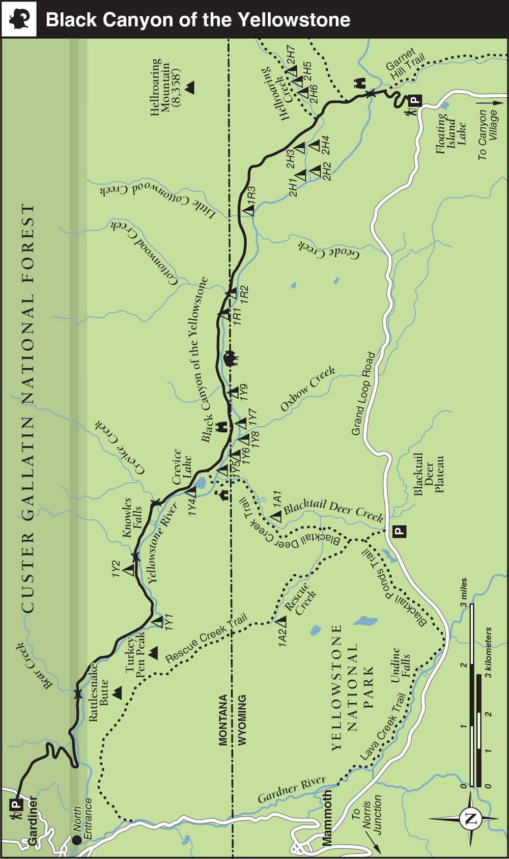
9. Black Canyon of the Yellowstone
12. Yellowstone River Picnic Area Overlook
Overleaf and opposite: Looking downriver, deep inside the lower Black Canyon of the Yellowstone (Trail 9)
Northeast Yellowstone: Tower/Roosevelt Country
Yellowstone’s northeastern quadrant encompasses the core of the park’s wildlife-rich Northern Range. It includes the developed areas around Tower Fall and Tower Junction (6,270 feet), the lower Yellowstone River drainage, and the Lamar River Valley. These unique areas include distinct ecological niches but when grouped together offer some of the most diverse and rewarding hikes in the park.
Grand Loop Road—the region’s only paved route—remains open to wheeled vehicles year-round between the North Entrance and Cooke City, just east of the Northeast Entrance (7,365 feet) in the park’s top-right corner. In winter, chains or snow tires may be required. The region is very popular with anglers and wildlife-watchers, who frequently fill the small and less-developed, National Park Service–run Slough Creek ($15) and Pebble Creek ($15) campgrounds to capacity, even outside of the high season. Another agreeable option is the 32-site Tower Fall Campground ($15), tucked away above Tower Creek in a pleasant forest.
Beyond the Northeast Entrance, the spectacular Beartooth Highway (US 212) was dubbed “the most beautiful drive in America” by roving TV journalist Charles Kuralt. The National Scenic Byway traverses the Beartooth Pass (10,947 feet; typically open Memorial Day weekend–mid-October; call 888-285-4636 for recorded travel conditions, construction, and alternate-route updates, or visit beartoothhighway.com) and a total of 65 stunning miles en route to the appealing outdoor base camp of Red Lodge, Montana. The route also provides easy access to many U.S. Forest Service campgrounds, trailheads, and scenic alpine hikes and backpacking routes in the Absaroka–Beartooth Wilderness.
Wildlife flocks to Yellowstone’s northeast corner for its lush riparian zones, wide-open expanses of grazing meadows, and attractive denning habitat. The Lamar Valley, often referred to as the Serengeti of America, is one of the most popular places in Greater Yellowstone for spotting wolves, elk, bison, and coyotes. Both black and grizzly bears frequently cause roadside “bear jams” around Tower Junction.
TRAIL FEATURES TABLE
The hiking terrain here runs the gamut, from low-lying overnight routes that trace the depths of the Black Canyon of the Yellowstone to high-altitude ascents that top out above timberline for never-ending views of the surrounding wildlands.
The rustic cabins at the summer-only Roosevelt Lodge (circa 1916; rates $89–$142), near President Theodore Roosevelt’s favorite campsite, are a popular base camp for families and anglers. The Yellowstone Association Institute (yellowstoneassociation.org) bases many of its field-study seminars nearby at the historic Lamar Valley Buffalo Ranch complex, where the United States’ last known mountain bison once survived in captivity. After the Yellowstone herd was counted at 23 in 1902, Great Plains bison were reintroduced, and ultimately the two species were allowed to interbreed in 1915. The ranch is generally not open to the public.
The last of Yellowstone’s once-extensive gray wolf population was exterminated in the Lamar Valley in the 1920s. In 1995 an unprecedented wolf reintroduction effort began with the release of 14 wild-captured Canadian gray wolves near Soda Butte and Druid Peak. The Montana state legislature unceremoniously responded to the federally sponsored reintroduction efforts by proposing that wolves be reintroduced smack-dab in the middle of pro-wolf territory: Central Park in New York City, the Presidio in San Francisco, and on the National Mall in Washington, D.C.
The last two of Yellowstone’s 31 reintroduced wolves died in early 2004. In 2015 there were 99 wolves running in 10 packs inside Yellowstone National Park, down from 170 wolves in 2007. Up to 500 wolves live in Greater Yellowstone.
After extensive, multiyear construction that widened Grand Loop Road over Dunraven Pass (8,859 feet) to accommodate modern RVs and improve safety, the route once again provides seasonal access to the Chittenden Road parking area (which provides access to the north slope of Mount Washburn) and Canyon Junction. Call 307-344-2117 for Dunraven opening dates and Yellowstone road-construction updates.
Permits and Maps
The only permits required here are for fishing and backcountry campsites along the Blacktail Deer Creek and Yellowstone River trails.
There’s no visitor center in the region, but the Tower Ranger Station (open 8 a.m.–4:30 p.m. daily in summer), housed in a reconstructed historic soldier station near Roosevelt Lodge, issues backcountry and fishing permits and can advise about current hiking conditions. The rustic, log cabin–style Northeast Entrance Ranger Station, a National Historic Landmark and a fine example of National Park Service “parkitecture” built between 1934 and 1935, may issue permits as well, depending on seasonal staffing levels.
The Trails Illustrated Tower/Canyon (no. 304, scale 1:63,360) map covers all of the hikes, trailheads, and campgrounds described in this chapter, except the Blacktail Deer Creek Trail and the western half of the Yellowstone River Trail, which appear on the Mammoth Hot Springs (no. 303, scale 1:63,360) and Yellowstone National Park (no. 201, scale 1:126,720) sheets in the same series. Beartooth Publishing’s Yellowstone North (1:80,000) covers the whole area.
Northeast Yellowstone: Tower/Roosevelt Country
Black Canyon of the Yellowstone
Though a shuttle is required, this classic downhill hike through a picturesque river canyon is an early-and late-season favorite of park employees. It’s a popular fishing and wildlife-watching route and is just far enough away from the road to give the illusion of being in the wilderness.
TRAIL 9
TRAIL Hike, Backpack, Horse
18.5 miles,
Point-to-point
Difficulty: 1 2 3 4 5
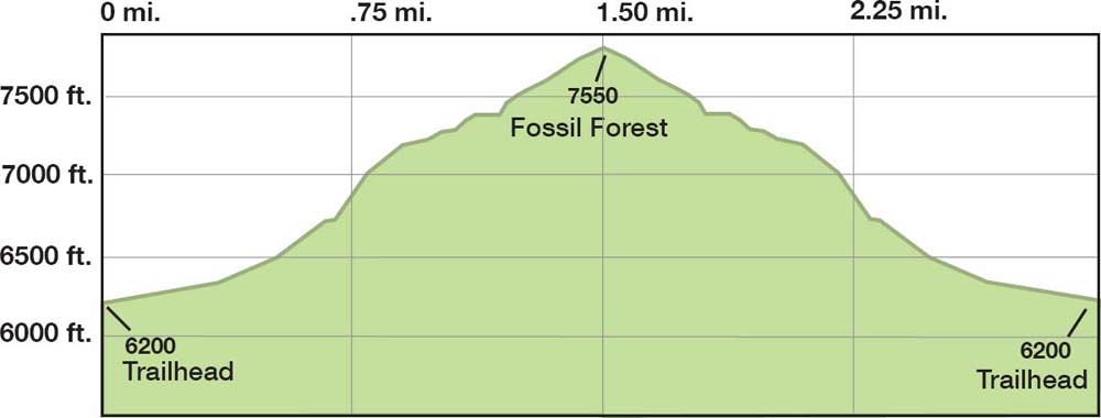
Fossil Forest
This steep, lightly traveled, heart-thumping ascent is the most direct of several unmarked but well-beaten paths that access Yellowstone’s most extensive petrified forest, high up a ridge with endless views. A must for amateur geologists.
TRAIL 10
Hike
3 miles, Out-and-back
Difficulty: 1 2 3 4 5
Trout Lake
An easy, family-friendly hike that combines a lovely lake, views of craggy peaks, good fishing, and even some off-trail exploring to keep the grown-ups happy. Early morning or late afternoon are the best times.
TRAIL 11
Hike
1.8 miles, Out-and-back
Difficulty: 1 2 3 4 5
Yellowstone River Picnic Area Overlook
Bring your binoculars: this family-friendly jaunt provides quick access to unobstructed views of the Grand Canyon of the Yellowstone and the Absaroka Range. There’s also intriguing geology, plus a good chance of spotting coyote and several different ungulates outside of the summer months.
TRAIL 12
Hike
4 miles, Out-and-back
or Loop
Difficulty: 1 2 3 4 5
Black Canyon of the Yellowstone
TRAIL USE
Hike, Backpack, Horse
LENGTH
18.5 miles, 1–4 days
VERTICAL FEET
+1,800/–1,250
DIFFICULTY
– 1 2 3 4 5 +
TRAIL TYPE
Point-to-point
SURFACE TYPE
Dirt
FEATURES
Backcountry Permit
Canyon
Stream
Waterfall
Autumn Colors
Wildflowers
Birds
Wildlife
Great Views
Photo Opportunity
Camping
Swimming
Secluded
Geologic Interest
Steep
FACILITIES
Horse Staging
This classic downhill hike is an early- and late-season favorite of park employees because the campsites are snow-free as soon as early May and as late as October. It’s just far enough away from the road for you to start feeling like you’re in the wilderness and is a prime route for fishing and wildlife-watching.
Best Time
The trail is typically dry enough for hiking by mid-May. The ford of Hellroaring Creek, however, can be waist-deep and tricky as late as August during years of high runoff. Ticks are a nuisance in spring and early summer. The route is hot at midday in summer and can be frosty in the early morning but is bug- and snow-free early and late in the season, when many of the park’s higher-elevation trails are in worse shape.
Finding the Trail
From the west, go 14.1 miles east from Mammoth (toward the Tower–Roosevelt junction) on Grand Loop Road and turn left into the signed Hellroaring trailhead (2K8) parking area (labeled a “gravel pit” on some older maps), which is 0.3 mile down a good gravel road on the north side of the road. From the east, go 3.4 miles west (toward Mammoth) from Tower–Roosevelt junction on Grand Loop Road and turn right into the parking area.
The exit (western) trailhead used to be in the town of Gardiner, Montana, but a private landowner withdrew permission for hikers to cross a section of land, so the trail has been rerouted in the last couple of years. The trailhead is now beside the horse corrals at the National Forestry Service–run Eagle Creek Campground, just northeast of Gardiner. From the park’s North Entrance, pass through the Roosevelt Arch and turn right on Park Street. After a couple of blocks, turn left on Second Street and cross the Yellowstone River Bridge. Turn right on Jardine Road and head uphill 2.2 miles to Eagle Creek Campground. The corral parking is at the end of one of the campground’s loop roads. Eagle Creek has 15 exposed campsites ($7) but no water. For details, contact the Custer Gallatin National Forest office at 805 Scott St. W. in Gardiner; call 406-848-7375.
Winter-kill carcasses are an important source of sustenance for predators and carrion scavengers in the Northern Range. For this reason, it might often feel like you are walking through an ill-tended graveyard in early spring.
Logistics
Most people prefer to do this hike one-way in the downhill direction (east to west), which requires a car shuttle. If in doubt about fording Hellroaring Creek, use the stock bridge crossing upstream. It’s an extremely long, strenuous day hike, so consider spreading it over two to four days to allow ample time for fishing, easygoing hiking, and plenty of relaxing. You really can’t go wrong with any of the campsites along the route, though all prohibit wood fires. Your selection will likely be determined by availability and how many nights you will be camping.

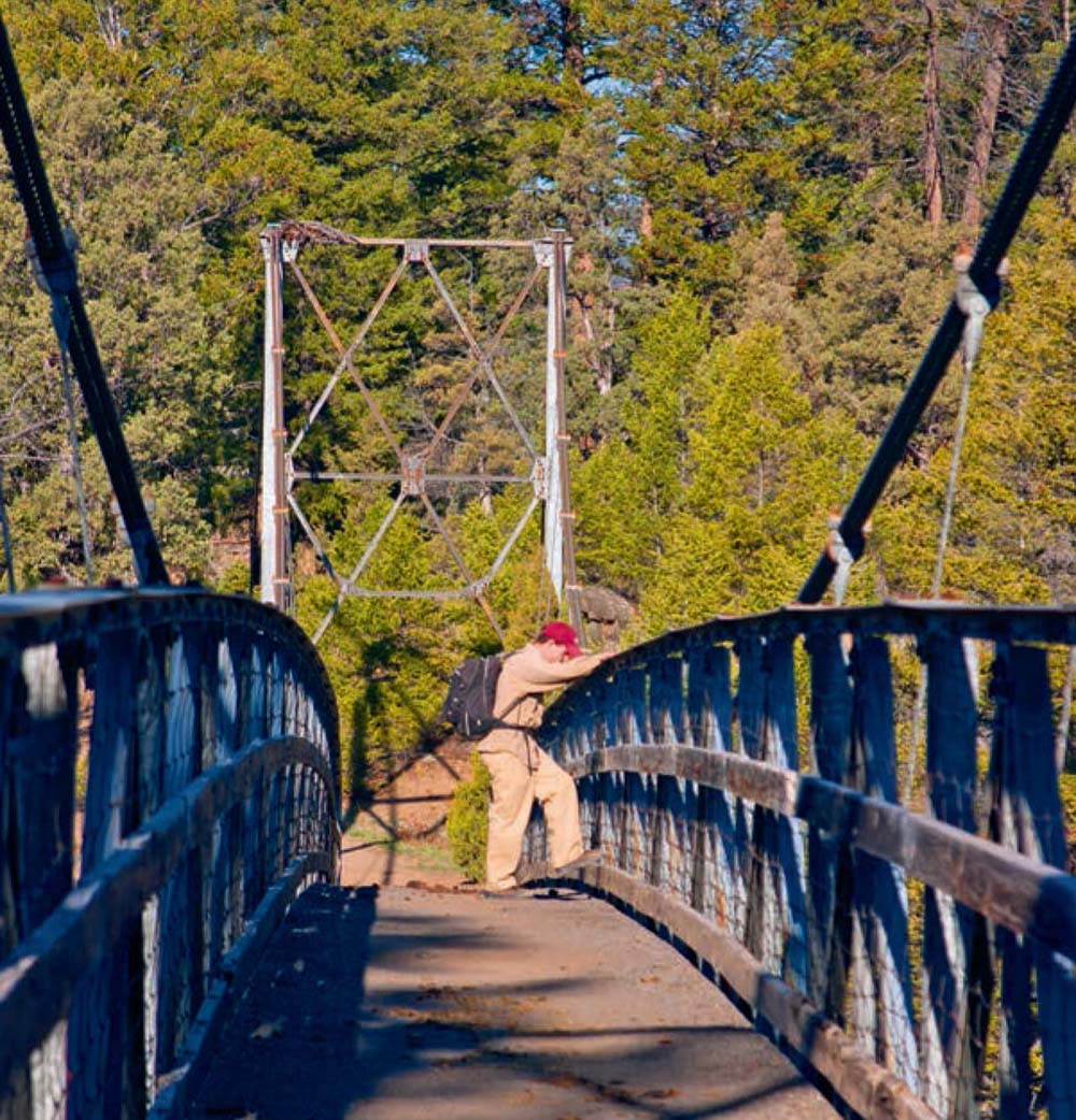
Yellowstone River suspension bridge: Bradley Mayhew contemplates the whitewater raging through the narrows far below.
Trail Description
Viewpoint 
From the Hellroaring trailhead ▸1 (2K8) parking lot, a singletrack, earthen trail that receives heavy horse use winds down through damp Douglas-fir forest to an overlook of the Yellowstone River, with Garnet Hill looming to the right across Elk Creek.
Wildflowers 
Starting at a small burn area, the trail switch-backs down steeply for a total of 600 feet over the first mile, past the Garnet Hill Trail junction ▸2 after 0.7 mile, through open grasslands dotted with wild-flowers to the brawny steel Yellowstone River suspension bridge, ▸3 which is bookended by juniper trees and just wide enough for two skinny horses.
Blacktail Deer Creek Shortcut
By starting at the Blacktail Deer Creek (1N5) trailhead, you can shorten the route by about 5 miles, joining the main canyon trail near the Lower Blacktail Patrol Cabin. Another short alternative is to make an out-and-back jaunt to the Yellowstone River bridge—a short but steep day hike, with a 1,600-foot total elevation change and a length of 2 miles round-trip.
Gardiner’s Best Burger
After a grueling hike, the only thing better than a soak in the Boiling River (see Trail 2) is a half-pound buffalo cheeseburger and thick huckleberry shake at the Wild West Corral Drive-In (406-848-7627, 711 W. Scott St.), on the western end of the main drag in Gardiner.
Geologic Interest 
After checking out the whitewater roaring far below, you climb away from the river through a rocky canyon and over a sagebrush plateau, past the Buffalo Plateau–Coyote Creek Trail junction ▸4 to Hellroaring junction, ▸5 at 2 miles from the trail-head, where Hellroaring Mountain (8,358 feet), the park’s biggest exposed granite outcropping, looms in the background.
Camping 
Your next move depends on the season and your destination. Before August, you’ll want to scout the condition of the potentially tricky Hellroaring Creek ford, ▸6 a few hundred yards beyond the junction and around the left side of the glacial lake basin (which is dry by late summer), to decide whether you would rather use the stock bridge, 1.5 miles upstream from the junction. All even-numbered campsites along Hellroaring Creek are on the south bank, and odd-numbered sites are on the north bank. These sites are the obvious first-night choice if you’re planning a three-night trip.
Hellroaring Creek was named by an early explorer who reported that it was a “real hell roarer.”
From the junction on the north side of Hellroaring Creek, ▸7 east-to-west-trending trails lead off to more campsites. If you’ve crossed via the stock bridge, turn right at this intersection. Fronting the confluence of Hellroaring Creek and the Yellowstone River, the ideal campsite, 2H1, ▸8 is accessed either along the north bank of the creek via the spur trail for campsite 2H3 or a few hundred yards later via a cutoff from the main trail. Both of these watercourses are blue-ribbon fishing spots for cutthroat trout after high waters recede, starting around mid-July.
The Black Canyon of the Yellowstone has one of the densest collections of predators in the Lower 48, with one wolf, mountain lion, or grizzly bear for every 2 square miles.
Canyon 
The trail climbs away from the river, crossing a varied landscape of minor marshes, small glacial lakes, and open sagelands. As you switchback more than 300 feet up a ridge, the impressive outline of Electric Peak (10,992 feet) comes into view near the crest. The trail descends to the roomy campsite 1R3, ▸9 perched high above the river 4.3 miles from the trailhead, before crossing Little Cottonwood Creek. ▸10 The views here down into the beginnings of the Black Canyon of the Yellowstone are stunning.
Camping
Appropriately, there’s no signage announcing the Wyoming–Montana state line, ▸11 as this abstract political delineation 5.7 miles from the trailhead has no effect on your experience. A few hundred yards farther along, campsites 1R2 ▸12 (hiker-only) and mixed-use 1R1 ▸13 are equally attractive, situated well off the trail on benches high above the river, with easy access to water around the mouth of Cottonwood Creek.
Wildlife 
Swimming 
Watch for elk antlers protruding from trees and ankle-busting badger burrows in the trail as it descends for a long, flat, forested stretch alongside the river. A couple of miles farther, past trailside bison wallows, hiker-only campsites 1Y9 ▸14 and 1Y7 ▸15 are 8.3 and 9 miles from the trailhead, respectively. Both sites are superb first-night riverfront options if you’re making a two-day trip. Late in the season, sandy swimming beaches are exposed below the towering outcroppings of columnar basalt.
Camping
Just before the Blacktail Bridge and 9.8 miles from the trailhead, hiker-only campsite 1Y5 ▸16 enjoys a secluded riverfront setting. If you’ve opted for the Blacktail Deer Creek Trail shortcut, you’ll join the Yellowstone River Trail at the junction, ▸17 several hundred yards ahead on the north side of the bridge. The hiker-only campsites 1Y6 and 1Y8 are across the bridge, east of the Lower Blacktail Patrol Cabin, 0.4 and 0.8 mile, respectively, down a spur trail along the south bank of the river.
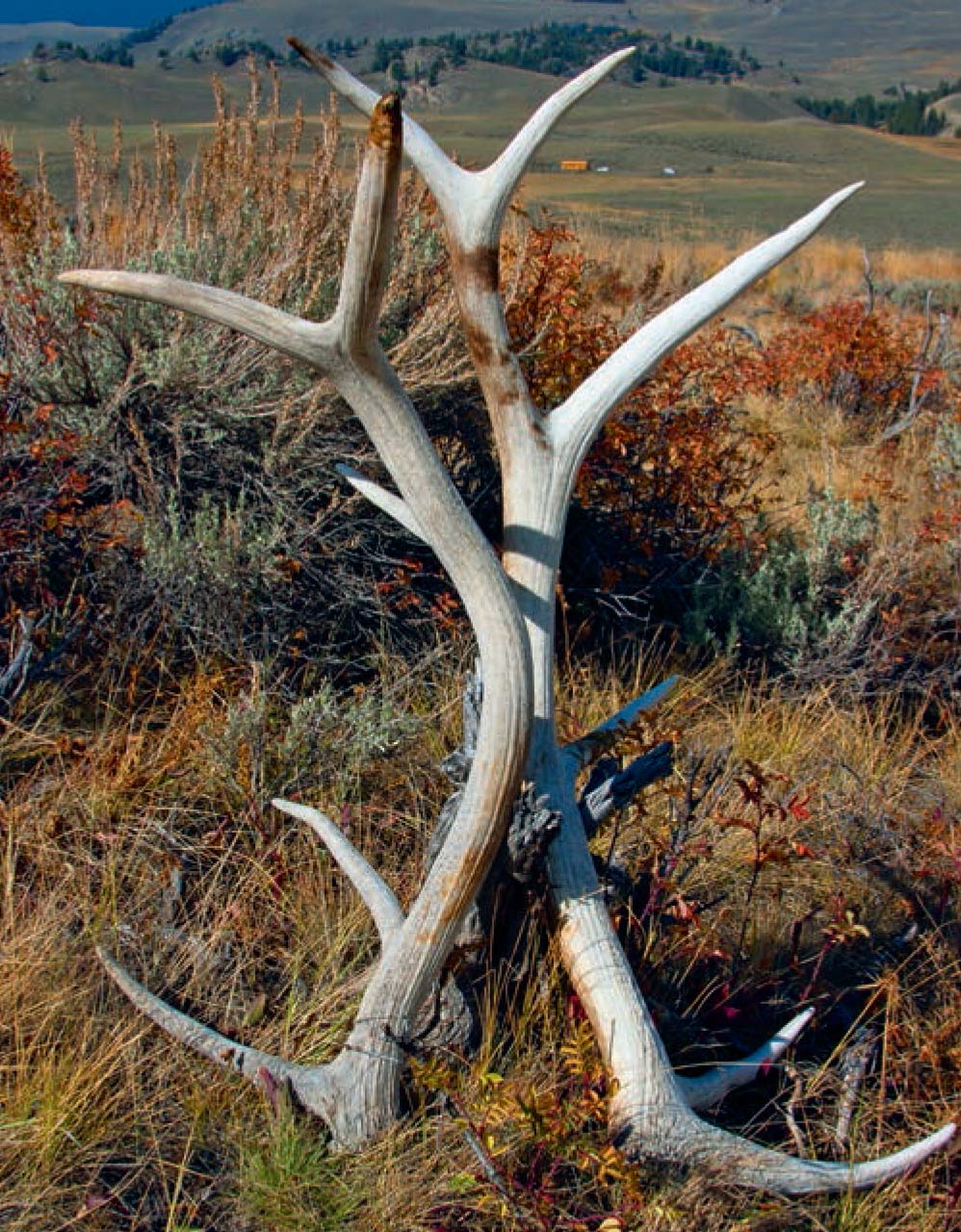
Elk antlers: Yellowstone’s wildlife-rich Northern Range is an important over-wintering refuge for elk and other large mammals.
The trail skirts the northern shore of the fishless, aquamarine Crevice Lake, ▸18 which has no inlet or outlet but is a nice spot for a cool dip on a hot day. Because of the steep banks and lack of shade around the lake, the best spots for breaking your daylong hike in half with a picnic lunch are just before the lake or a few hundred yards beyond it, near the riverfront, hiker-only campsite 1Y4, ▸19 10.6 miles from the trailhead.
The trail leaves the river again to cross Crevice Creek ▸20 on a sturdy bridge 11.4 miles from the trailhead. This is a good place to tank up on water before the final bone-dry homestretch. Note: Most maps incorrectly depict an abandoned trail here heading right up the creek to a patrol cabin and the park’s northern boundary.
Waterfall 
Beyond, the trail begins an alternating pattern of climbing up above the river and winding through massive fields of scree and lichen-encrusted glacial boulders before switchbacking down steeply to the river. Beyond the first such climb and descent, a short spur trail leads down to the viewpoint for the 15-foot Knowles Falls, ▸21 11.8 miles from the trailhead, where the cascade’s volume is more impressive than its height.
Camping
Next you reach flats leading to the hiker-only campsites 1Y2 ▸22 (12.4 miles from the trailhead) and 1Y1, ▸23 which is beyond an impressive narrows, 13.5 miles from the trailhead. Both of these sites front the river but are not entirely secluded from the trail. Beyond the campsites, keep an eye out for snakes on the trail and bald eagles perched in the cottonwoods. As the river calms below the falls and changes color from jade green to ashy gray, you’ll see more willows along the shore and cacti near the trail. This change in flora ushers in the final hot and dry 5-mile stretch, which some hikers opt to skip by exiting via the Blacktail Deer Creek trailhead (1N5).
The head-high browse lines visible on tree trunks indicate just how desperate some animals become during the depths of the six-month winter.
The trail slaloms through park boundary markers en route to a sturdy old wooden bridge over the appealing Bear Creek. Just past the bridge, the newly rerouted trail branches to the right, near a large, dormant thermal terrace, and starts the hot, tiring final climb up to Eagle Creek Campground, climbing 800 feet over the next 2 miles or so. After dipping into the drainage of Bear Creek, the trail switchbacks up a ridge to cross the main Gardiner– Jardine road and finally arrives at the horse corrals of Eagle Creek Campground ▸24.
 MILESTONES
▸1 0.0 Start at Hellroaring trailhead parking lot
▸2 0.7 Left at Garnet Hill Trail junction
▸3 1.0 Yellowstone River suspension bridge
▸4 1.6 Left at Buffalo Plateau–Coyote Creek Trail junction
▸5 2.0 Left at Hellroaring junction for low-water Hellroaring Creek ford and campsites 2H2 and 2H4; right for high-water stock bridge crossing and campsites 2H6, 2H8, and 2H9
▸6 2.2 Hellroaring Creek ford
▸7 2.3 Straight at junction; left for campsites 2H3 and 2H1; right for campsites 2H5 and 2H7
▸8 2.6 Campsite 2H1 cutoff/spur trail
▸9 4.3 Campsite 1R3 spur trail
▸10 4.5 Little Cottonwood Creek
▸11 5.7 Wyoming–Montana state line (no sign)
▸12 5.9 Campsite 1R2 spur trail
▸13 6.0 Campsite 1R1; Cottonwood Creek
▸14 8.3 Campsite 1Y9 spur trail
▸15 9.0 Campsite 1Y7 spur trail
▸16 9.8 Campsite 1Y5 spur trail
▸17 10.0 Right at Blacktail Deer Creek Trail junction; left for bridge, patrol cabin, and campsites 1Y6 and 1Y8
▸18 10.3 Crevice Lake
▸19 10.6 Campsite 1Y4 spur trail
▸20 11.4 Crevice Creek bridge
▸21 11.8 Knowles Falls
▸22 12.4 Campsite 1Y2 spur trail
▸23 13.5 Campsite 1Y1 spur trail
▸24 18.5 Arrive at Eagle Creek Campground
TRAIL 10 NORTHEAST YELLOWSTONE
Fossil Forest
TRAIL USE
Hike
LENGTH
3.0 miles, 2–3 hours
VERTICAL FEET
±1,350
DIFFICULTY
– 1 2 3 4 5 +
TRAIL TYPE
Out-and-back
SURFACE TYPE
Dirt, Paved
FEATURES
Mountain
Summit
Autumn Colors
Wildflowers
Birds
Wildlife
Great Views
Photo Opportunity
Secluded
Geologic Interest
Steep
FACILITIES
None
This short but steep and challenging ascent is the most direct of several unmarked routes that end up at Yellowstone’s most fascinating and significant petrified forest, located high up a ridge, with amazing, endless views.
Best Time
There is neither shade nor water at the trailhead or along the route, so early morning or later in the afternoon is best, and be sure to carry enough water. The primary hiking season is June–October. Wildflowers are abundant after the snowmelt in July and August.
Finding the Trail
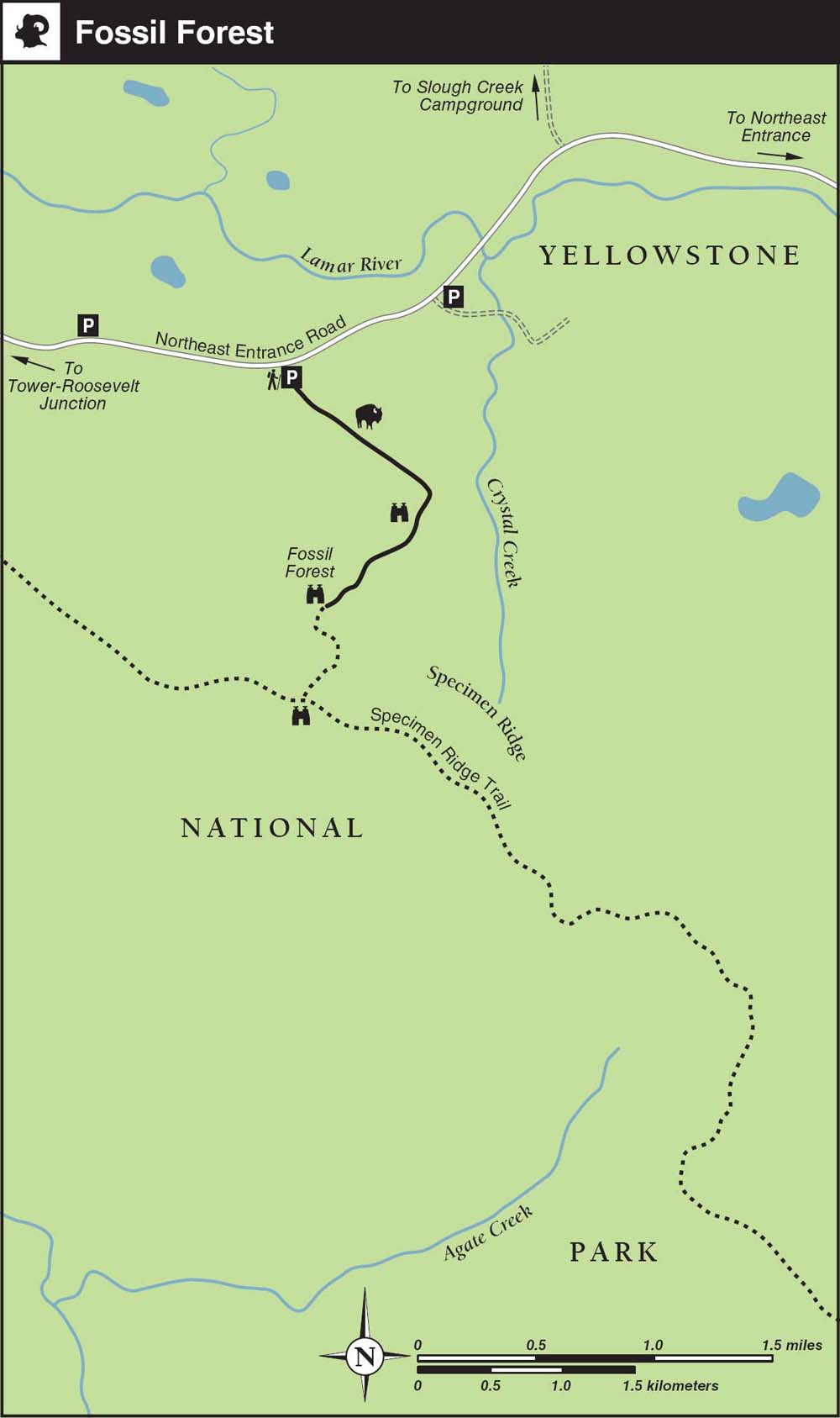
Finding the unsigned trailhead takes a bit of extra attention. From the west, head 4.1 miles east on the Northeast Entrance Road from the Tower–Roosevelt junction—1.2 miles past the signed Specimen Ridge trailhead parking area—and watch for a small, unsigned, paved turnout on the south (right) side of the road. From the east, go past the turnoff for Slough Creek Campground on Northeast Entrance Road, then 0.5 mile past the bridge over the Lamar River. Don’t confuse the parking turnout you want with another signed trailhead and parking area that has a designated handicapped parking spot and is just 0.2 mile past the bridge, where an old service road heads south up the Crystal Creek drainage.
If you have binoculars, before you head out, scan the ridge from the roadside turnouts to identify your destination: a pair of large, rocky outcroppings next to a forested patch below the crest of Specimen Ridge. Once you’ve found the correct parking area, you should be able to identify the trail heading up the ridge with the naked eye. Be aware that the temperature changes as fast as the elevation gain. Bring a jacket, as afternoon thundershowers are common and it can get a bit brisk up top.
Trail Description
Wildflowers
From the parking turnout, ▸1 an unsigned but well-beaten path heads south across the sagebrush foothills, through several bison wallows toward a group of lichen-encrusted, granitic glacial erratic boulders ▸2 situated atop a small rise about 0.3 mile from the road. The ensuing steep beeline up the hillside will really get your calves and heart pumping. When tired, stop and smell the blossoms: the meadows here are usually bursting with wildflowers by July.
Watch closely as you climb, and you may begin to notice small fossilized shards. Trust me, you will be looking down at your feet a lot during this athletic climb. At times it feels like you are on a StairMaster set at 10-plus.
Steep 
You will begin to notice small, upright fossilized stumps off to the left as spur trails branch off near the top of the ridge. Fall colors peak here around the end of September, a bit later than elsewhere in the park. Behind you, views of the Northern Range are unsurpassed.
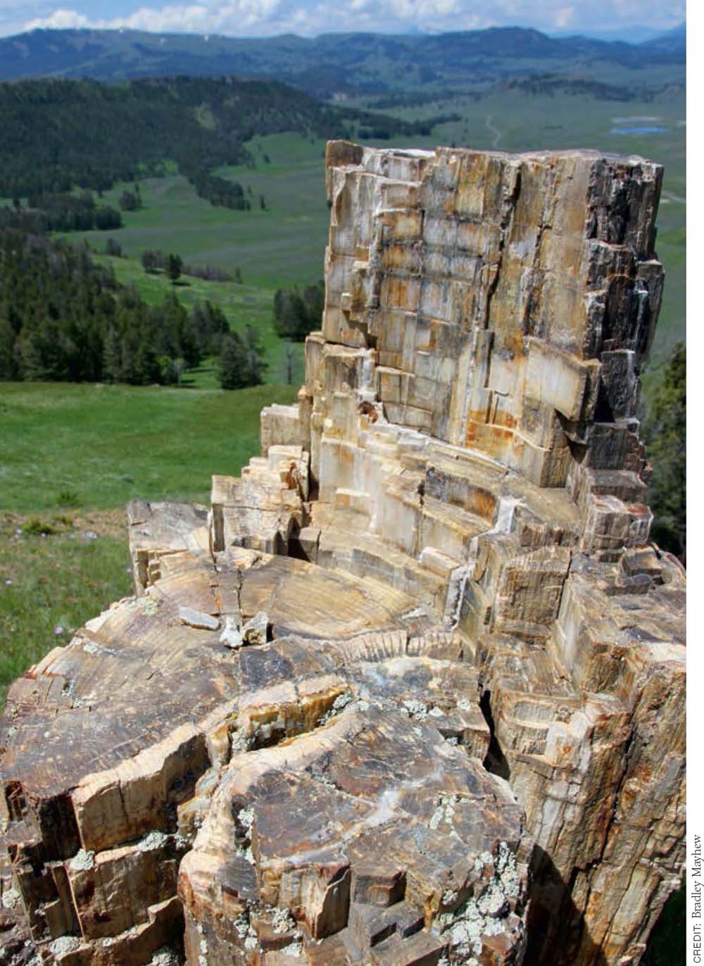
Literally acres are littered with small shards of petrified material; you can hardly pitch a horseshoe here off the various informal trails without hitting an ossified stump: dogwoods, magnolias, oaks, walnuts, maples, and even avocado and breadfruit. As you crest the ridge, the trail joins another path trending northwest–southeast along the ridgeline. Look back north toward the trailhead to see the footprint of glacial lakes and the Absaroka Range.
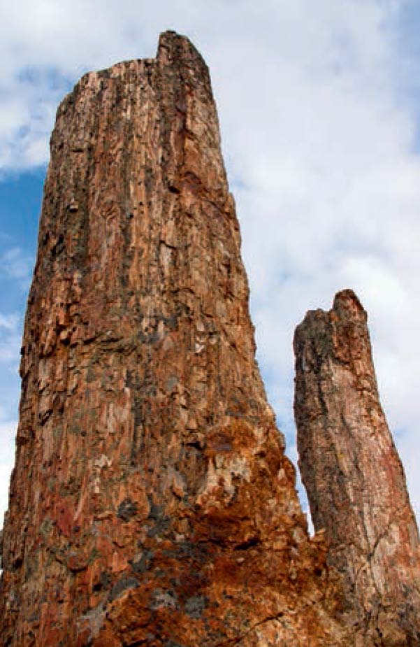
Twin petrified pine trees, some 50 million years old, stand upright in the Fossil Forest below Specimen Ridge.
Geologic-Interest
Follow the ridgeline, keeping a burn area to your left and a Douglas-fir forest to your right, exploring the various unofficial “social” paths if you have the energy. Upon emerging from a small patch of forest, a gigantic upright fossilized redwood stump ▸3 and two smaller standing pine trunks appear about 1.5 miles from the parking area. Take care on the rocky slope if you descend to inspect the redwood’s exposed root structures. The silica-induced petrification occurred during volcanic phases over a 15-million-year period, starting perhaps as far back as 55 million years ago.
Geologic-Interest
The National Park Service strictly prohibits the collection of any fossilized materials; please leave this mind-boggling place as you found it. (For a sad example of what can result from illegal souvenir hunting, visit the greatly diminished Petrified Tree near the Tower–Roosevelt junction. If you must take a piece of geologic history home with you, the Custer Gallatin National Forest issues permits for small-scale collection in the Tom Miner Basin).
Steep
From here, you have three options: climb straight up, go straight down, or retrace your steps back to the trailhead. If you have a reserve of energy, the brisk 400-foot climb up to the top of Specimen Ridge is highly recommended. You’ll be rewarded by a scenic picnic spot with breathtaking views southwest across the Grand Canyon of the Yellowstone to Mount Washburn (the lookout tower is barely visible). From the summit it’s about one hour back to the trailhead. Less advisable are the steep, unstable social paths that plunge higgledy-piggledy down along the western edge of the forest.
If you are feeling less spry, poke around a bit for more stumps, and then retrace your steps for the gentlest way back down to the trailhead parking area. ▸4
The adjacent Crystal Creek drainage was used as an elktrapping site in the early 1950s and was home to one of three acclimatization pens during the 1995 wolf reintroduction.
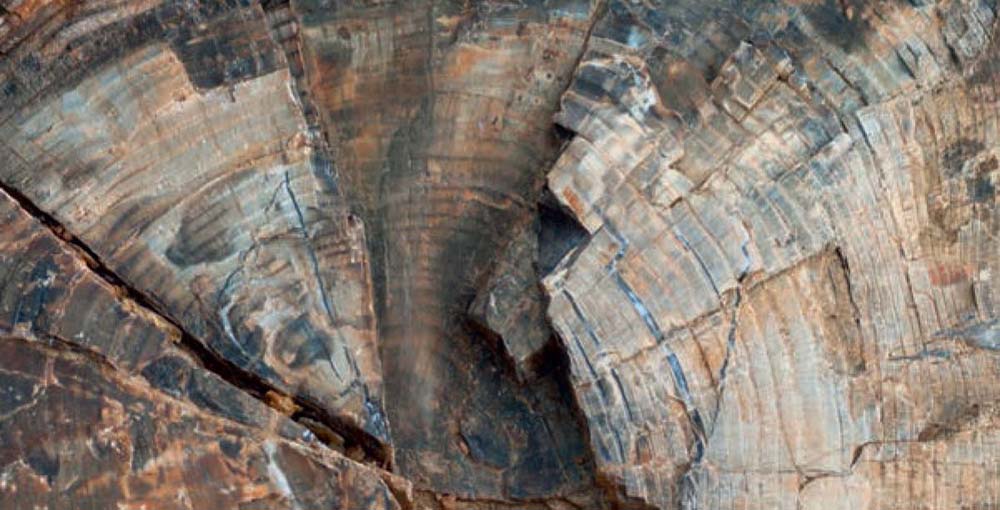
Details of rings on a fossilized tree stump
Petrified trees and fine valley views are the highlights of the Fossil Forest Trail.
MILESTONES
▸1 0.0 Start at unsigned parking turnout
▸2 0.3 Glacial boulders
▸3 1.5 Fossil Forest
▸4 3.0 Return to trailhead
TRAIL 11 NORTHEAST YELLOWSTONE
Trout Lake
TRAIL USE
Hike
LENGTH
1.8 miles, 1.5 hours
VERTICAL FEET
Negligible (±230)
DIFFICULTY
– 1 2 3 4 5 +
TRAIL TYPE
Out-and-back
SURFACE TYPE
Dirt
FEATURES
Child Friendly Mountain Lake Cool & Shady Great Views
FACILITIES
None
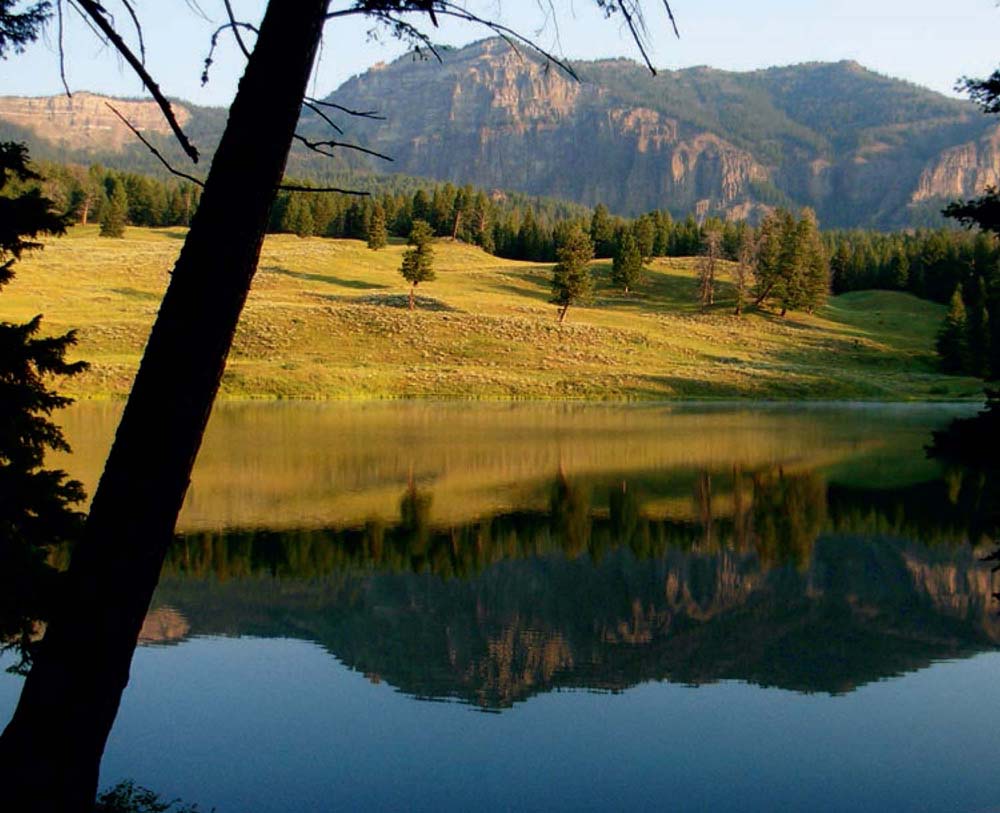
This easy, family-friendly stroll to a charming pond is especially lovely in the early-morning light, and there’s some scope for simple off-trail exploring. It’s a popular trail with anglers.
Best Time
The trail is accessible year-round, as the Northeast Entrance Road from Mammoth to Cooke City is open year-round, but you’ll need snowshoes in winter. The trail gets warm on summer afternoons.
Finding the Trail
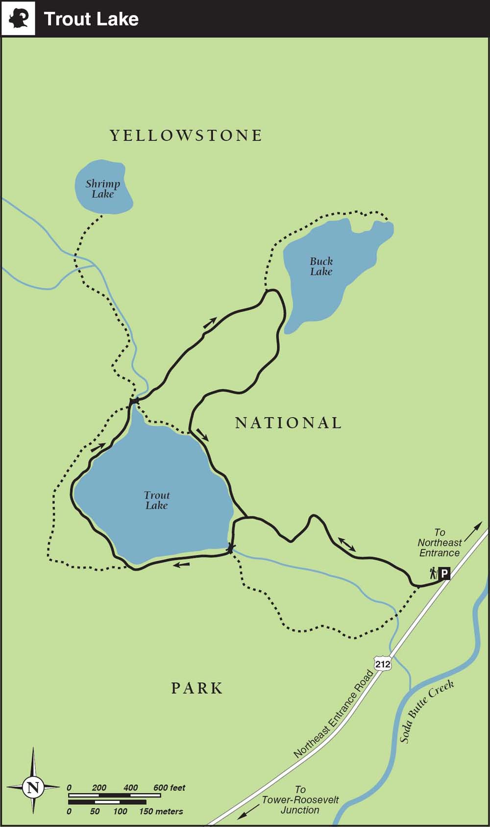
From the west, drive 18 miles east on the Northeast Entrance Road from Tower Junction, passing the Lamar Valley and Soda Butte before turning into the small signed parking lot on the left.
From the Northeast Entrance it’s an 11-mile drive on the Northeast Entrance Road; the parking lot is 1.5 miles past the Pebble Creek Campground. The small parking lot holds only a half-dozen vehicles, so get here early. There is no toilet or water at the trailhead, but there are nearby picnic spots at the Soda Butte picnic area.
Logistics
Trout Lake is popular with anglers who come for cutthroat and rainbow trout; the cutthroat are catch-and-release only, the rainbow must be killed. Fishing starts on the Saturday of Memorial Day weekend. The inlet stream is closed to fishing at any time. You will need a Yellowstone National Park fishing permit, not a Wyoming permit.
Bad-weather day, or need to keep the kids occupied? Pick up the Yellowstone: Color It Wild coloring book, published by the Yellowstone Association, or the national park’s version of Monopoly. Both are available in bookstores at the park’s major visitor centers.
Trail Description
Viewpoint
As you leave the parking lot ▸1 the immediate climb might put off young families, but don’t worry—the uphill section lasts less than 10 minutes. The trail climbs within earshot of the lake’s outlet stream past a meadow offering views of The Thunderer peak before curving around to reach the natural bowl of Trout Lake. ▸2 Follow the trail clockwise around the lake, crossing a sturdy log bridge over the outlet stream. The craggy ridge of Mount Hornaday (10,036 feet) looms behind the lovely lake. A small clearing on the southeast side of the lake marks a minor junction where an unofficial path heads southeast for five minutes to a forested knoll boasting views of Soda Butte and the Lamar Valley beyond. Head back to the junction and continue left on the upper of two trails that offer views above the lake.
Viewpoint
On the north side of the lake, you’ll cross the inlet stream. ▸3 For the shortest version of this hike, continue around the lake and back to the parking area for a 1.2-mile hike. If you are willing to explore a bit, add on 30 minutes of walking by taking the middle path just after the inlet bridge on an unofficial but clear trail, and briefly climb a miniature ridge for an overview of Trout Lake. The clear trail then continues for five minutes to Buck Lake, ▸4 with its views of Amphitheater (10,662 feet) and Abiathar (10,928 feet) peaks near the park’s northeastern border near Silver Gate.
 Lake
Lake
Continue a short way around the left shore, and you’ll see the main trail leading back to Trout Lake. ▸5
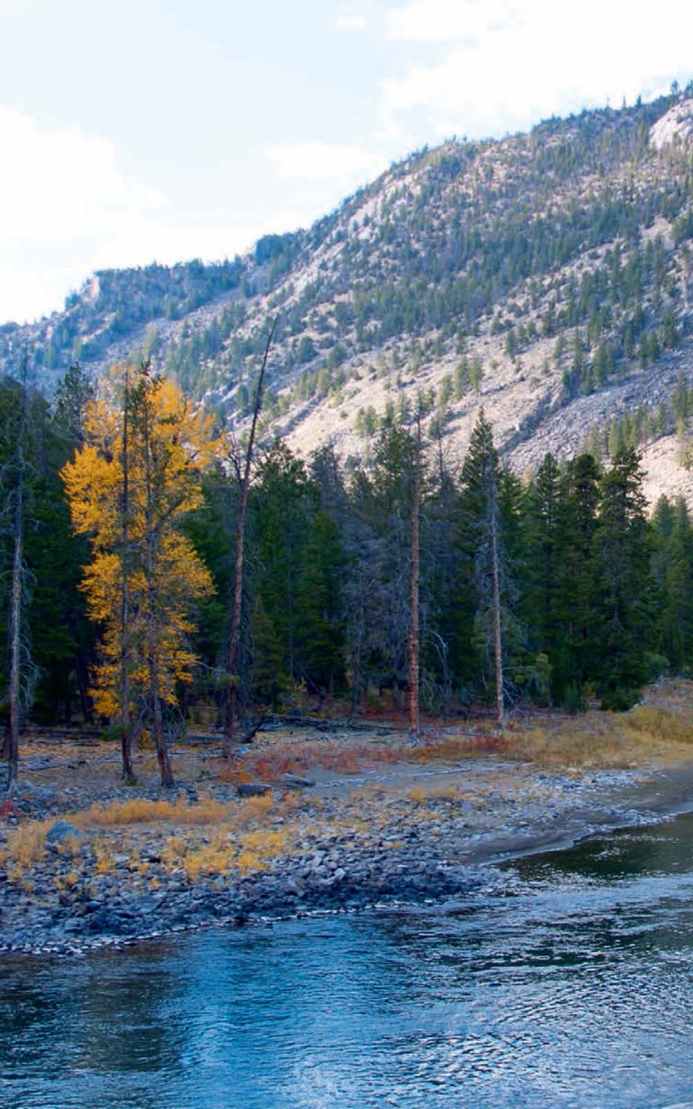
Peaceful Trout Lakein morning light
CREDIT: Bradley Mayhew
From Trout Lake it’s a 10-minute walk downhill back to the parking lot. ▸6 Back at the inlet bridge, explorers can follow paths that climb the left side of the Trout Lake inlet stream, eventually crossing the stream to climb to overgrown Shrimp Lake.
MILESTONES
▸1 0.0 Start at parking lot
▸2 0.3 Trout Lake
▸3 0.7 North Inlet
▸4 1.0 Buck Lake
▸5 1.25 Trout Lake
▸6 1.8 Parking lot
TRAIL 12 NORTHEAST YELLOWSTONE
Yellowstone River Picnic Area Overlook
TRAIL USE
Hike
LENGTH
4.0 miles, 1.5–2 hours
VERTICAL FEET
+200
DIFFICULTY
– 1 2 3 4 5 +
TRAIL TYPE
Out-and-back or Loop
SURFACE TYPE
Dirt
FEATURES
Child Friendly
Canyon
Wildflowers
Birds
Wildlife
Great Views
Photo Opportunity
Geologic Interest
Geothermal
FACILITIES
Restrooms
Picnic Tables
Bring your binoculars: this easy, family-friendly hike provides opportunities to spot wildlife and offers quick access to unobstructed views of both the Grand Canyon of the Yellowstone and the Absaroka Range. Turn around wherever you like, or complete the loop by following the start of the Specimen Ridge Trail.
Best Time
The exposed trail can get hot in the summer, but it’s enjoyable whenever the weather is decent. The hiking season runs May–October, making it a good early- and late-season choice. Wildflower-watchers are happiest here in spring.
Finding the Trail
From the west, go 17.5 miles east from Mammoth Hot Springs on Grand Loop Road to the Tower– Roosevelt junction. Turn left (northeast) on the Northeast Entrance Road and go 1.2 miles (0.5 mile past the Yellowstone River bridge) before turning right into a parking area just west of the signed picnic area and trailhead on the south side of the road. Leave the parking spots at the trailhead for cars using the picnic area.
From the Northeast Entrance, go 27.8 miles southwest on the Northeast Entrance Road, and turn left into the parking lot.
From Canyon Village to the south, go 19 miles north over Dunraven Pass (8,859 feet) on Grand Loop Road, and turn right (northeast) at Tower Junction; then continue 1.2 miles, and turn right into the picnic area.
In the parking area, ignore several unofficial social trails; the official (signed) trailhead is by the picnic table just to the left (east) of the restroom. All the trails end up in the same place.
Trail Description
Canyon
In the picnic area, ▸1 look for the trailhead on the east side of the parking lot. The earthen trail climbs 200 feet in the first few hundred yards for a breathtaking start to a breathtaking hike.
Wildlife
Once atop the hill, stop for a peek down into The Narrows of the Grand Canyon of the Yellowstone ▸2 some 800 feet below. Can you hear the river roar? Take extra care with the kids near the precipitous canyon rim—there are no safety railings here in the backcountry. The Tower–Canyon road and its overhanging cliffs of columnar basalt, remnants of former lava flows, are visible across the canyon. Keep your eyes out for bighorn sheep scampering along the canyon’s sheer walls.
Geothermal 
About halfway along the trail, at 1.2 miles, you don’t need an acute sense of smell to pick up on the sulfur odor wafting out of the active Calcite Springs ▸3 thermal area on the opposite side of the canyon. Look for ospreys in the canyon, as fabulous views open up of the breccia towers that loom above the Yellowstone River.
After 2 miles, the route reaches a viewpoint and potential picnic spot at a three-way junction with the Specimen Ridge Trail. ▸4 Below you lies the Bannock Ford, a wide and shallow crossing of the Yellowstone River that was a favorite of Bannock hunters as they traversed the park. From here, you can either retrace your steps to the trailhead or continue along the trail, taking the left fork at the junction with the Specimen Ridge Trail toward the Specimen Ridge trailhead (2K4) to finally loop left back to the picnic area and parking lot. ▸5 Both return routes require approximately the same amount of time and effort. If opting for the loop, watch closely for an unsigned and easily missed path heading off to the left just before you reach the road to avoid having to finish up this otherwise scenic final stretch on the pavement.
Bannock Trail
The Bannock Trail was probably used off and on for centuries by American Indian tribes. Its current name comes from its frequent use in the 1800s by the Bannock, who crossed the Yellowstone Plateau when heading for the plains east of the park to hunt bison, after the totem animal was exterminated from the Snake River Plains, the tribe’s homeland. They crossed the Yellowstone River upstream from its confluence with Tower Creek, in the canyon far below the junction with the Specimen Ridge Trail. Many people have assumed this ford was an ancient crossing. However, archaeological investigations have found no evidence of repeated, long-term use.
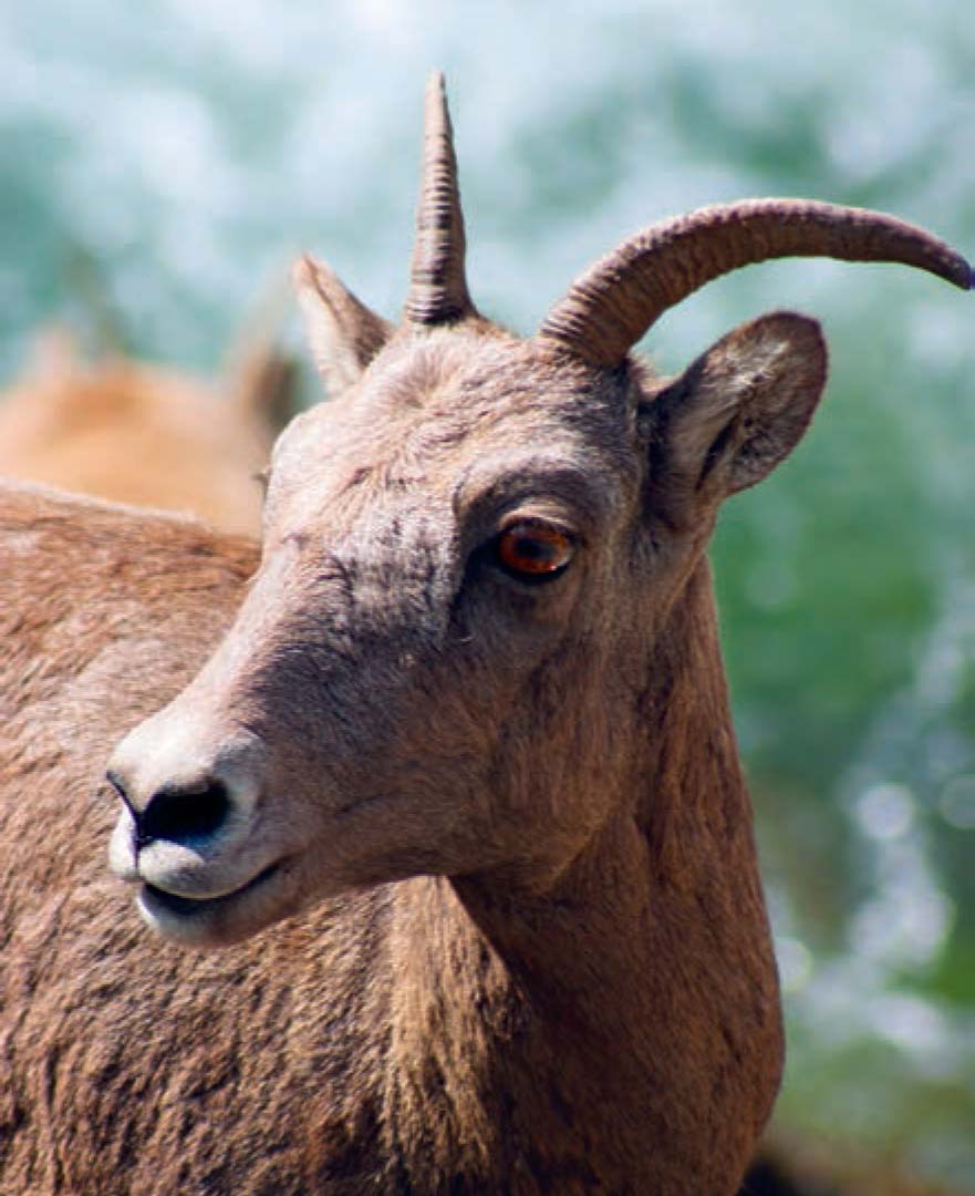
Female bighorn sheep are frequently seen scampering down-canyon to the Yellowstone River.
Basalt cliffs line the Narrows section of the Yellowstone River.
MILESTONES
▸1 0.0 Start at Yellowstone River Picnic Area trailhead
▸2 0.2 Grand Canyon of the Yellowstone overlook
▸3 1.2 Calcite Springs Overlook
▸4 2.0 Specimen Ridge Trail junction
▸5 4.0 Return to parking lot
 OPTIONS