CHAPTER 5
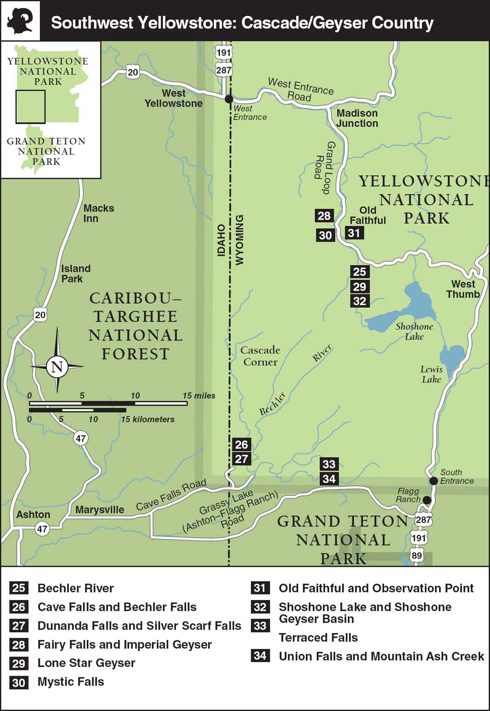
Southwest Yellowstone: Cascade and Geyser Country
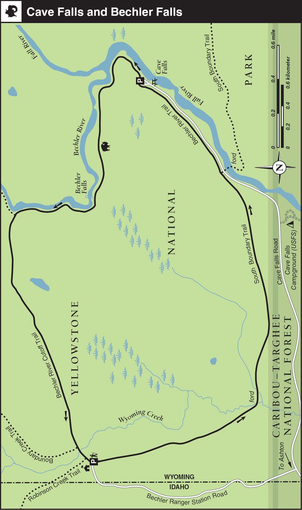
26. Cave Falls and Bechler Falls
27. Dunanda Falls and Silver Scarf Falls
28. Fairy Falls and Imperial Geyser
31. Old Faithful and Observation Point
32. Shoshone Lake and Shoshone Geyser Basin
34. Union Falls and Mountain Ash Creek
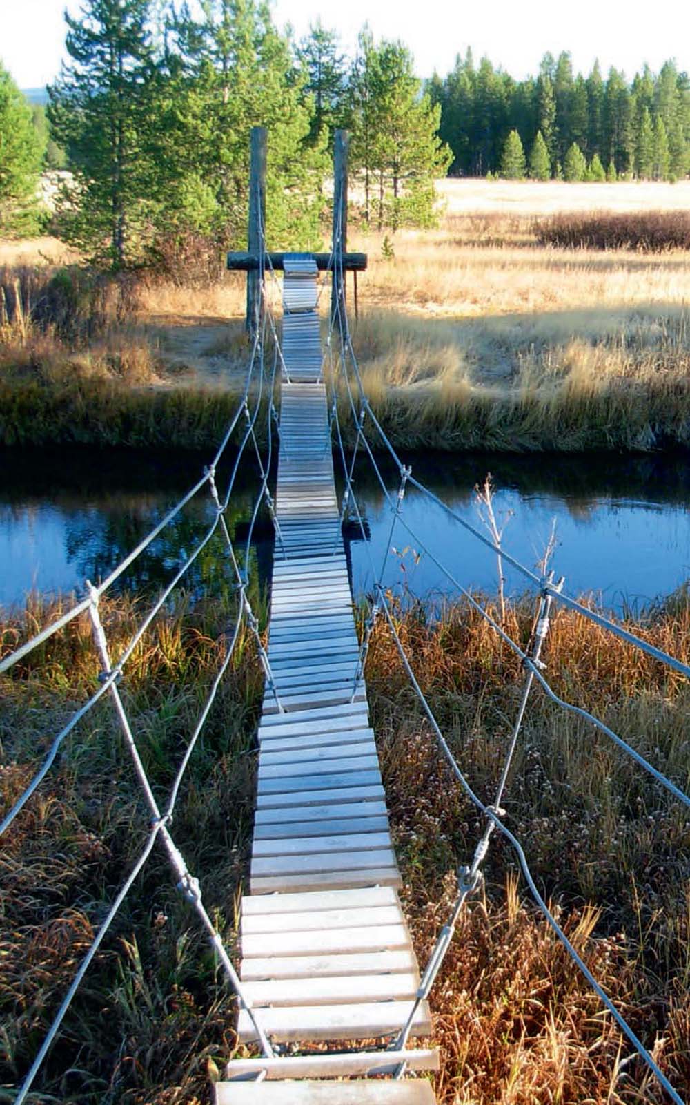
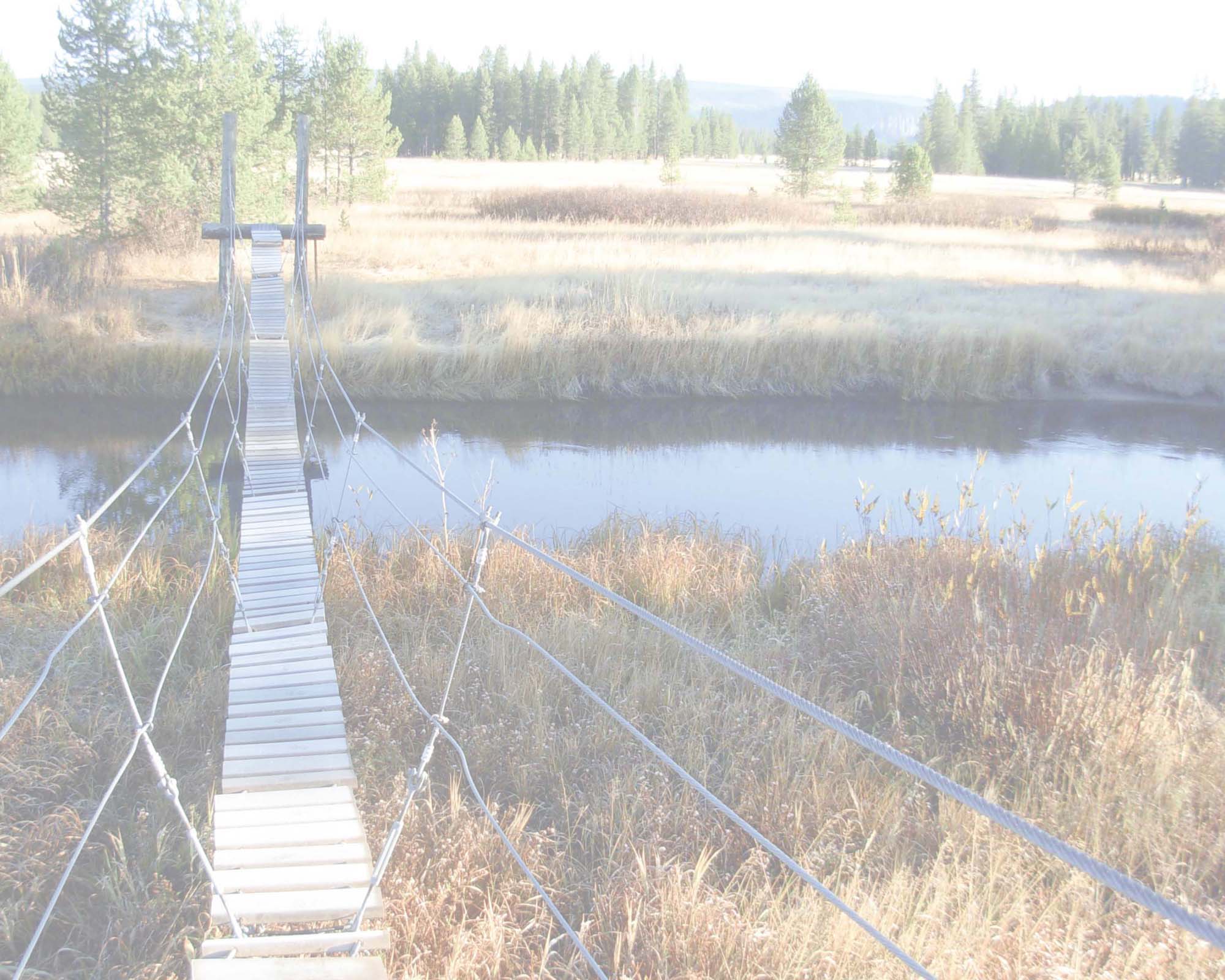
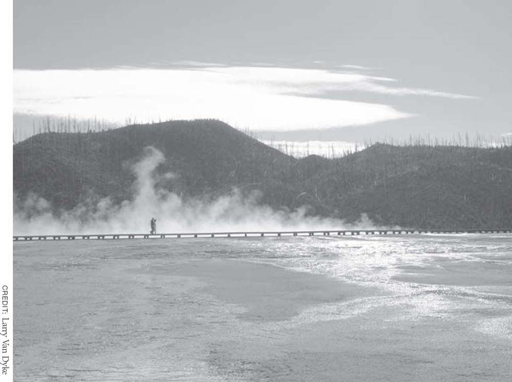
Hiking in the Bechler region requires wading across several rivers; this suspension bridge offers a rare dry crossing (Trail 25).
CREDIT: Bradley Mayhew
Southwest Yellowstone: Cascade and Geyser Country
Yellowstone’s southwest corner exemplifies why one of the earliest nicknames for the park was America’s Wonderland. Before the park was established in 1872, explorers queried respected periodicals back east about publishing their accounts of encounters with the region’s astounding geysers, wildlife, and thermal features. The response was unanimous: “Sorry, we don’t publish fiction.”
Today, the region’s world-famous geothermal features are as active and popular as ever. The pilgrimage to the Old Faithful is obligatory for first-time visitors, and a wander through the gushing surrounding Upper Geyser Basin never fails to impress. Beyond the frontcountry boardwalks, several of the park’s most spectacular geysers and waterfalls await only short distances from roadside trailheads.
The Lamar Valley and Old Faithful aside, many frequent visitors claim that the Cascade Corner is Yellowstone’s most captivating region. For those with a few days to spare, overnight backpacking and boating around Shoshone Lake offer enticing escapes from the crowds. Accessing the relative solitude of the 200-square-mile Bechler backcountry (pronounced BECK-ler; also known as the Cascade Corner thanks to its many waterfalls) requires some dedication, since it’s a long drive outside the park—from either West Yellowstone or the South Entrance.
The nearest developed campground to Old Faithful is at Madison Campground ($23.50), 16 miles north of Old Faithful, at which you can (and should) reserve sites in advance. There are also several easy overnight options at nearby backcountry campsites, most of them discussed in this chapter’s trail descriptions.
The century-old Old Faithful Inn (open early May–early October; doubles $115–$268, suites $503–$572), a National Historic Landmark built in 1903–04 with native logs, is worth a visit to see the spectacular architecture even if you aren’t able to reserve a room or dine there. The original “Old House” rooms in both the east and west wings completed an $11 million restoration in late 2008, but some still have shared bathrooms down the hall. You’ll need to book six months in advance to get a room at the inn.
Nearby, the less atmospheric Old Faithful Lodge (open mid-May–late September) has basic cabins ($88) with shared toilets, and motel-style units ($148) with private bathrooms. The shared showers ($4) in the lodge are available to nonguests; pick up a towel at the reception desk.
The modern Old Faithful Snow Lodge (open early May–mid-October and mid-December–mid-March; cabins $114–$163, rooms $264–$284) is a hive of activity, particularly in winter. The West Entrance Road between West Yellowstone, Montana; Madison Junction; and Old Faithful typically opens for oversnow travel (including cross-country skiing, snow coaches, and snowmobiles) in mid-December and is groomed until mid-March.
Depending on the weather, the vehicle-free period in early spring—before the road opens around the third week in April—can be a magical time to explore Grand Loop Road. While park service crews perform spring road maintenance, visitors can bicycle, jog, in-line-skate, or explore via other nonmotorized means between the West Entrance and Mammoth, and sometimes between Norris Geyser Basin and Canyon Village. Contact the National Park Service at 307-344-2117 to verify seasonal opening schedules. (See page 16 for more details on the spring bicycling period.)
Permits and Maps
The only permits required for hikes in this chapter are for fishing, boating, and overnight stays at the region’s numerous and popular backcountry campsites.
The recently remodeled Old Faithful Visitor Center is the park’s busiest information center, receiving upwards of 25,000 visitors per day. Besides answering the million-dollar question (Q: When is Old Faithful scheduled to erupt? A: There’s no “schedule.”), rangers issue permits and lead free interpretive walks through the geyser basins. There’s also a good bookstore and a theater that screens short films timed to start just after an eruption of Old Faithful. Call 307-545-2750; open daily, 8 a.m.–8 p.m. in summer; hours are reduced in fall and winter.
The remote, summer-only Bechler Ranger Station also issues permits, but it’s best to arrange for permits and campsite reservations at another backcountry office (see the Appendix, for a complete list) before trekking all the way out to the park’s bottom-left corner. For the Bechler Ranger Station, call 406-581-7074; open daily, 8 a.m.–4:30 p.m., in summer.
National Geographic’s Trails Illustrated Old Faithful (no. 302, scale 1:63,360) map shows all the hikes, trailheads, and campgrounds described in this chapter.
Southwest Yellowstone: Cascade and Geyser Country
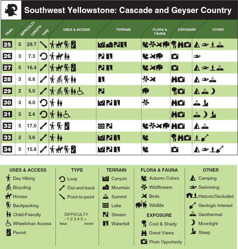
Bechler River
The Cascade Corner comes as close as any region in Yellowstone to having it all—prime fishing, soakable hot springs, and lots of wildlife. This three- to five-day backcountry route passes by many of the region’s highlights. And with a car shuttle, it’s downhill most of the way.
TRAIL 25
Hike, Backpack, Horse
29.7 miles, Point-to-point
Difficulty: 1 2 3 4 5
Cave Falls and Bechler Falls
This easy loop avoids river fords and provides a sample of what the remote Bechler region has to offer. It’s not worth the drive by itself, but it is a nice easy hike if you already happen to be in the area.
TRAIL 26
Hike, Horse
7.3 miles, Loop
Difficulty: 1 2 3 4 5
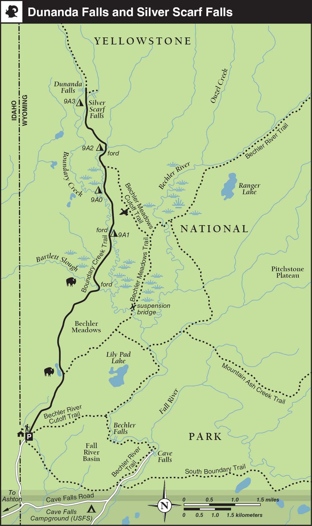
Dunanda Falls and Silver Scarf Falls 220
This long but rewarding route offers a good sample of the Cascade Corner’s varied delights: lush riparian zones; vast, wildlife-rich meadows; sublime hot pots; mesmerizing waterfalls; and invigorating stream crossings. And it is easily extended into a moderate overnight trip.
TRAIL 27
Hike, Backpack, Horse
16.4 miles, Out-and-back
Difficulty: 1 2 3 4 5
Fairy Falls and Imperial Geyser
This family-friendly outing is a perfect length to take a sack lunch on the trail, and it affords a tantalizing taste of what’s so wonderful about Yellowstone’s back-country. One of the park’s tallest waterfalls, intriguing geothermal features, and easy camping options await surprisingly close to the Grand Loop Road.
TRAIL 28
Hike, Bike, Backpack
5.2 or 6.8 miles
Out-and-back
Difficulty: 1 2 3 4 5
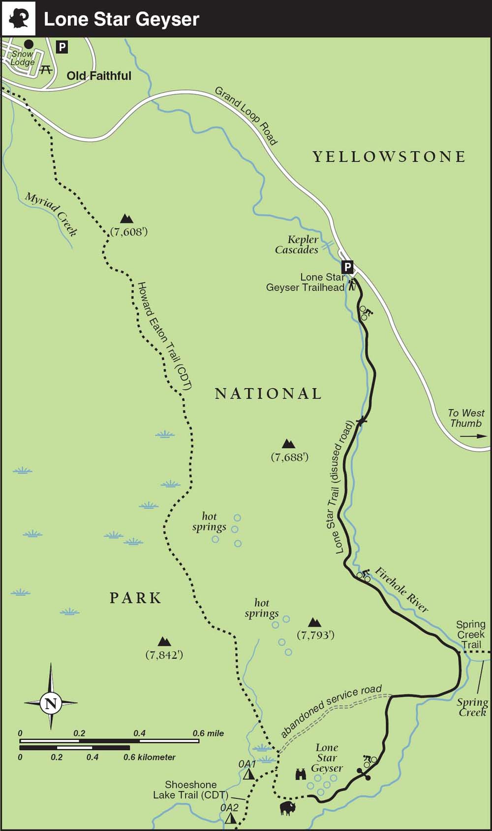
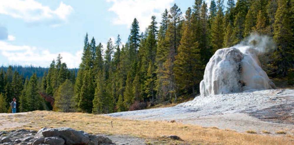
Lone Star Geyser
This easy stroll or quick bike ride along an abandoned road leads to one of the park’s most dependable and impressive backcountry geysers. The alternative Howard Eaton Trail is a popular cross-country ski track in winter.
TRAIL 29
Hike, Bike, Backpack
5.0 miles, Out-and-back
Difficulty: 1 2 3 4 5
Mystic Falls
Since it’s so close to Old Faithful, this easy jaunt is quite popular with dayhikers and rewards them with a pretty backcountry cascade. The full loop leaves the crowds behind and provides an unparalleled overview of the Upper Geyser Basin.
TRAIL 30
Hike
4.0 miles, Loop
Difficulty: 1 2 3 4 5
Old Faithful and Observation Point 243
If you haven’t seen the most famous geyser in the world’s most active geyser basin, can you really say that you’ve been to Yellowstone? Visit during the full moon or make the short climb to Observation Point for a unique perspective on the iconic grand dame.
TRAIL 31
Hike
2.4 miles, Loop
Difficulty: 1 2 3 4 5
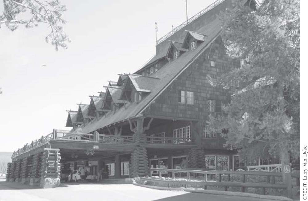
Old Faithful Inn is a classic example of National Park Service “parkitecture.”
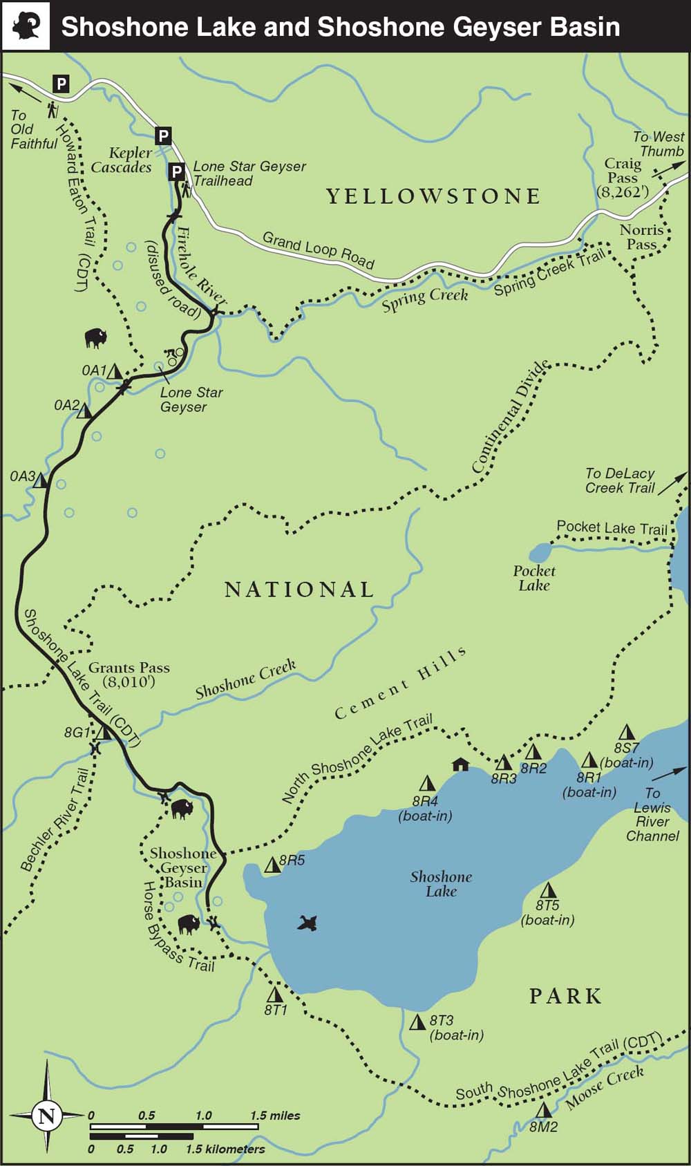
Shoshone Lake and Shoshone Geyser Basin
With no road access and no motorized boats allowed, forest-lined Shoshone Lake is the largest backcountry lake in the Lower 48 US states. It’s home to an amazing geyser basin and good fish-ing—and with the option of boat-in camping, it’s no surprise that it’s one of Yellowstone’s most popular overnight destinations.
TRAIL 32
Hike, Backpack
17.0 miles, Out-and-back
Difficulty: 1 2 3 4 5
Terraced Falls
This remote, lightly used trail is difficult to access but provides an up-close look at a large, multitier waterfall, set in a dramatic, volcano-forged canyon. It’s a great late-season choice and combines nicely with an overnight trip to Union Falls.
TRAIL 33
Hike, Horse
3.6 miles, Out-and-back
Difficulty: 1 2 3 4 5
Union Falls and Mountain Ash Creek
Greater Yellowstone’s most impressive backcountry waterfall and a sublime swimming hole are the rewards at the end of this hearty hike alongside lovely streams. Scoring a reservation at one of the popular campsites near the falls will allow you to extend this long dayhike into an easygoing overnight trip.
TRAIL 34
Hike, Backpack, Horse
15.8 miles, Out-and-back
Difficulty: 1 2 3 4 5
TRAIL 25 SOUTHWEST YELLOWSTONE
Bechler River
TRAIL USE
Hike, Backpack, Horse
LENGTH
29.7 miles, 3–5 days
VERTICAL FEET
+1,300/−2,100
DIFFICULTY
− 1 2 3 4 5 +
TRAIL TYPE
Point-to-point
SURFACE TYPE
Dirt
FEATURES
Backcountry Permit
Canyon
Mountain
Stream
Waterfall
Autumn Colors
Wildflowers
Birds
Wildlife
Cool & Shady
Great Views
Camping
Swimming
Secluded
Geothermal
FACILITIES
None
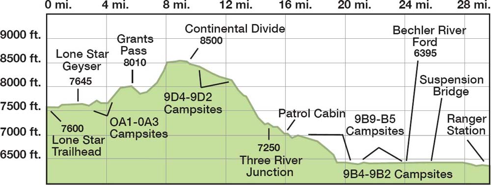
The Cascade Corner comes as close as any part of Yellowstone to having it all. This three- to five-day route passes by many of the region’s highlights. It’s tough to argue with good catch-and-release fishing, soakable five-star hot pots, lovely back-country campsites, and wildlife galore in the lower stretches—especially when the majority of the trail is downhill.
Best Time
Grants Pass (8,010 feet), between Lone Star Geyser and the west end of Shoshone Lake, typically isn’t free of snow until late June or early July. In Bechler Meadows, high water and pesky mosquitoes typically don’t subside until late July or early August. For these reasons, this trip is most popular in August and September, when advance reservations are essential. October conditions can be glorious, but snaps of foul weather are also quite possible.
Finding the Trail
From the north, head south from Old Faithful 2.7 miles on Grand Loop Road. Turn right into the parking area just past the Kepler Cascades turnout, signed for the Lone Star trailhead, on the south side of the road. From Grant Village, go west on Grand Loop Road from West Thumb Junction 14.5 miles over Craig Pass (8,262 feet), and turn left into the trailhead parking area.
Bechler’s backcountry campsites aren’t available for advance reservation until after July 15; some sites may be available earlier for in-person reservations, depending on weather conditions. During summer, it’s a good idea to reserve Bechler’s limited backcountry campsites as far in advance as possible. Most Bechler campsites may be reserved for only one or two nights. Contact the Bechler Ranger Station for an update on current weather, river-ford, and trail conditions.
Check the predicted eruption schedule for Lone Star Geyser at the Old Faithful Ranger Station so you can plan your departure time accordingly. Seeing this impressive geyser in action is worth fitting into your trip schedule.
The only nearby frontcountry camping option is the riverside U.S. Forest Service Cave Falls Campground (with water and restrooms), 1 mile east of the turnoff for the Bechler Ranger station ($10), in the Caribou-Targhee National Forest. There’s also plenty of room for dispersed camping in the surrounding national forests.
A car shuttle is necessary for this hike, and be prepared for a long drive. From the Lone Star trail-head, the easiest way to reach the Bechler Ranger Station is via the West Entrance and West Yellowstone. The winding, 105-mile drive takes at least four hours each way in favorable conditions. From Ashton, Idaho (60 miles and 1.5 hours south of West Yellowstone, Montana, via US 20), drive 10 miles east past Marysville, and jog left at the turnoff for Mesa Falls (ID 47) to reach Cave Falls Road. Continue 10 miles on the graded gravel road past the Idaho–Wyoming state line, and then turn left for the Bechler Ranger Station at the signed junction for Cave Falls.
Lone Star Geyser (Trails 25, 29, and 32)
The alternative route, via the South Entrance and the unpaved Grassy Lake Road, is only slightly shorter but is much rougher and takes even longer. From 2 miles south of Yellowstone’s South Entrance at Flagg Ranch, it’s possible to head 50 miles west on the unpaved Grassy Lake Road (variously called Ashton–Flagg Ranch Road, Reclamation Road, and USFS Road 261 on older maps) to reach a cutoff for Cave Falls Road. At the trailhead, park adjacent to the barn (if day hiking) or in the horse staging area (if staying overnight).
To arrange a commercial shuttle drop, contact a company like Yellowstone Roadrunner in West Yellowstone; call 406-640-0631 or visit yellow stoneroadrunner.com. Don’t leave any valuables in your vehicles at the trailheads, display your back-country permit inside your windshield, and register your plans with the Bechler Ranger Station. If you’re concerned about the security of your vehicle, park at the nearby Kepler Cascades turnout, which sees less traffic.
The Ferris Fork has plentiful waterfalls and intriguing thermal features
You definitely need to bring hiking sandals or wading shoes, plus trekking poles for added stability, and you need to be prepared to cross thigh-high rivers with your pack on. A camp towel and some kind of swimming attire are useful if visiting the Mr. Bubbles hot spring. Unless otherwise noted, campsites described here are hiker-only, allow wood campfires, and have a one-night limit.
From the Lone Star trailhead, ▸1 an abandoned service road heads south along the upper Firehole River. After passing the remains of an old water-works, the paved road traces the east bank of the river as it heads upstream.
Geothermal 
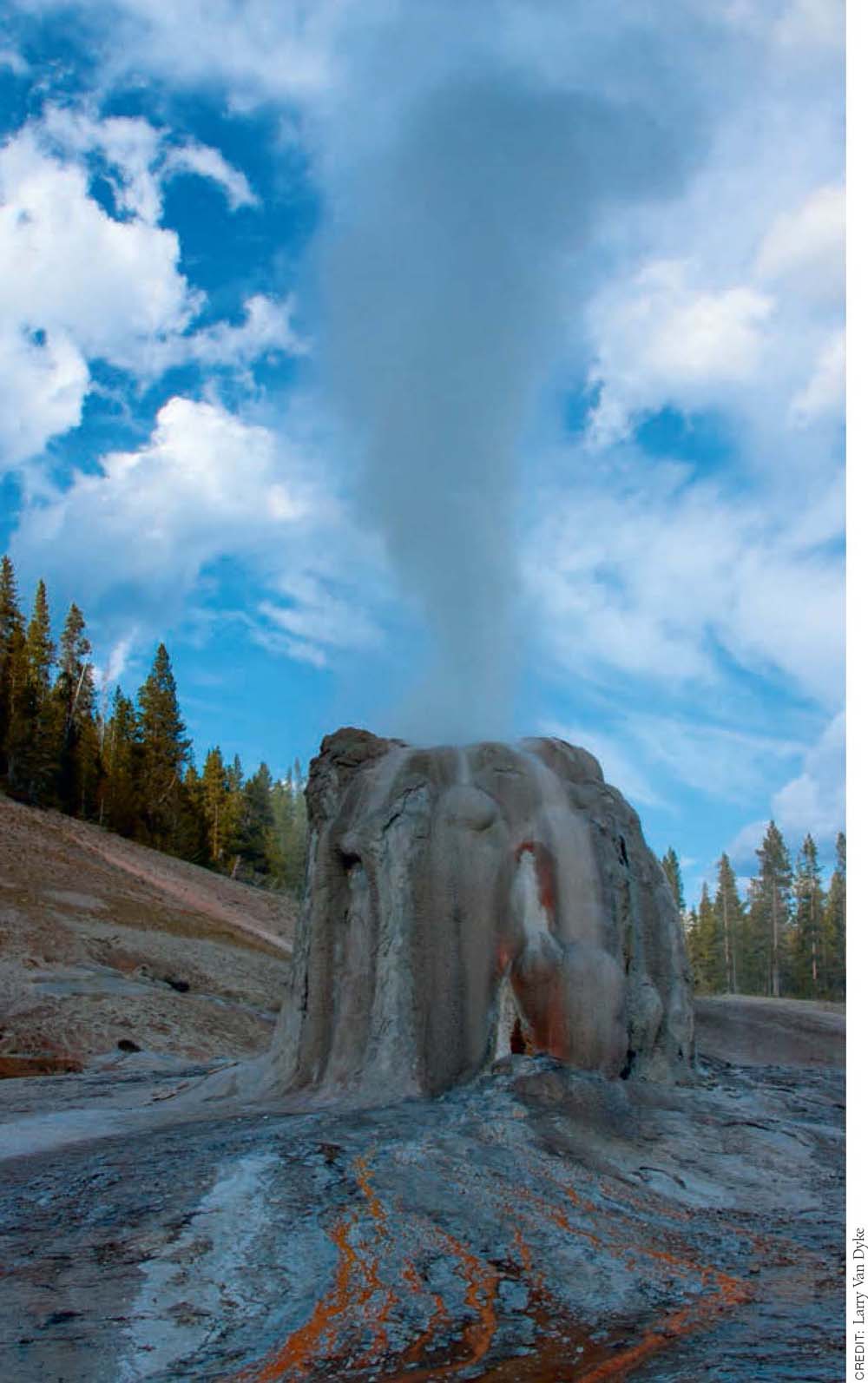
After passing the Spring Creek Trail ▸2 junction at 1.6 miles, you may hear Lone Star Geyser ▸3 before you see it. During its steam phase, it can be heard up to a mile away. Major eruptions occur like clockwork, every three hours on average, with significant preplay in between active phases. Allow about an hour to reach the geyser on foot from the trailhead. (For details about Lone Star Geyser, see Trail 29).
Wildlife 
A few hundred yards beyond the geyser basin, take a left at the well-signed Shoshone Lake Trail ▸4 junction, where bison are often spotted grazing and wallowing around thermal areas adjacent to the trail. If you are doing a five-day trip, you have three decent trailside options for first-night campsites in the next 1.5 miles.
Camping 
First up, the wide-open campsite OA1 ▸5 is the only one that also allows stock parties. Watch out for bison barging through in the middle of the night. Four hundred yards down-trail, across the Upper Firehole River, campsite OA2 ▸6 is your best choice. Almost a mile farther upstream, campsite OA3 ▸7 is near Firehole Springs. Beyond here, the trail leaves the river and starts to climb up to cross the Continental Divide.
Camping
If you choose not to linger here for fishing or geyser-gazing on your first day, you’ll have to contend with a 300-foot climb through unburned forest to unsigned Grants Pass (8,010 feet) ▸8 and a similar descent to the signed Bechler River Trail junction, ▸9 at 6.4 miles. The hiker- and llama-only campsite 8G1 (no wood fires) is a hundred yards to the left, off the Shoshone Lake Trail in Shoshone Meadows. If you can’t reserve a spot here, it’s a 2.5-mile detour down to the lovely campsite 8R5 (no wood fires), which fronts Basin Point Bay on the west shore of Shoshone Lake. If you stay here, don’t miss the opportunity to explore the Shoshone Geyser Basin, detailed in Trail 32.
Wildlife
If you have opted for the three-night plan, the absolute farthest you can comfortably go during your first day is 9.5 miles, crossing the Continental Divide (8,500 feet) again, to campsite 9D4. ▸10 The last first-night resort is the rocky campsite 9D3, ▸11 a popular stock-grazing site 1.2 miles farther along through meadows and prime moose habitat below Douglas Knob ▸12 (8,544 feet). Neither of these sites allows wood fires.
Waterfall 
It’s all downhill beyond 9D4. Below 9D3, the trail drops into the Littles Fork drainage, then crosses the Gregg Fork of the Upper Bechler River just before campsite 9D2, ▸13 a decent overnight option at 13.5 miles. Just downstream is the 55-foot Twister Falls cascade, out of sight but visible from a short spur trail. From here on down, you’re in the thick of the Waterfall Wonderland, first mapped in 1872 by the Hayden Survey’s chief topographer, Gustavus R. Bechler.
 OPTIONS
Variations
If you aren’t driving or you want to avoid the pavement and crowds en route to Lone Star Geyser, you can start south from the Howard Eaton trailhead, 1 mile south of Old Faithful, on part of the Continental Divide National Scenic Trail.
If it’s easier to arrange a shuttle to Bechler Ranger Station, you can do the hike in the uphill direction, but the northbound hike entails a total climb of more than 2,000 feet.
If you just can’t arrange a shuttle, you can do an out-and-back trip from Bechler Ranger Station to Ferris Fork and back in three or four days. Alternatively, combine Ferris Fork and Dunanda Falls on a fantastic four-day loop trip from Bechler Ranger Station.
Albright Falls was named in 1986 in honor of Horace Marden Albright, who helped to found the National Park Service in 1916 and who served as Yellowstone’s superintendent from 1919 to 1929.
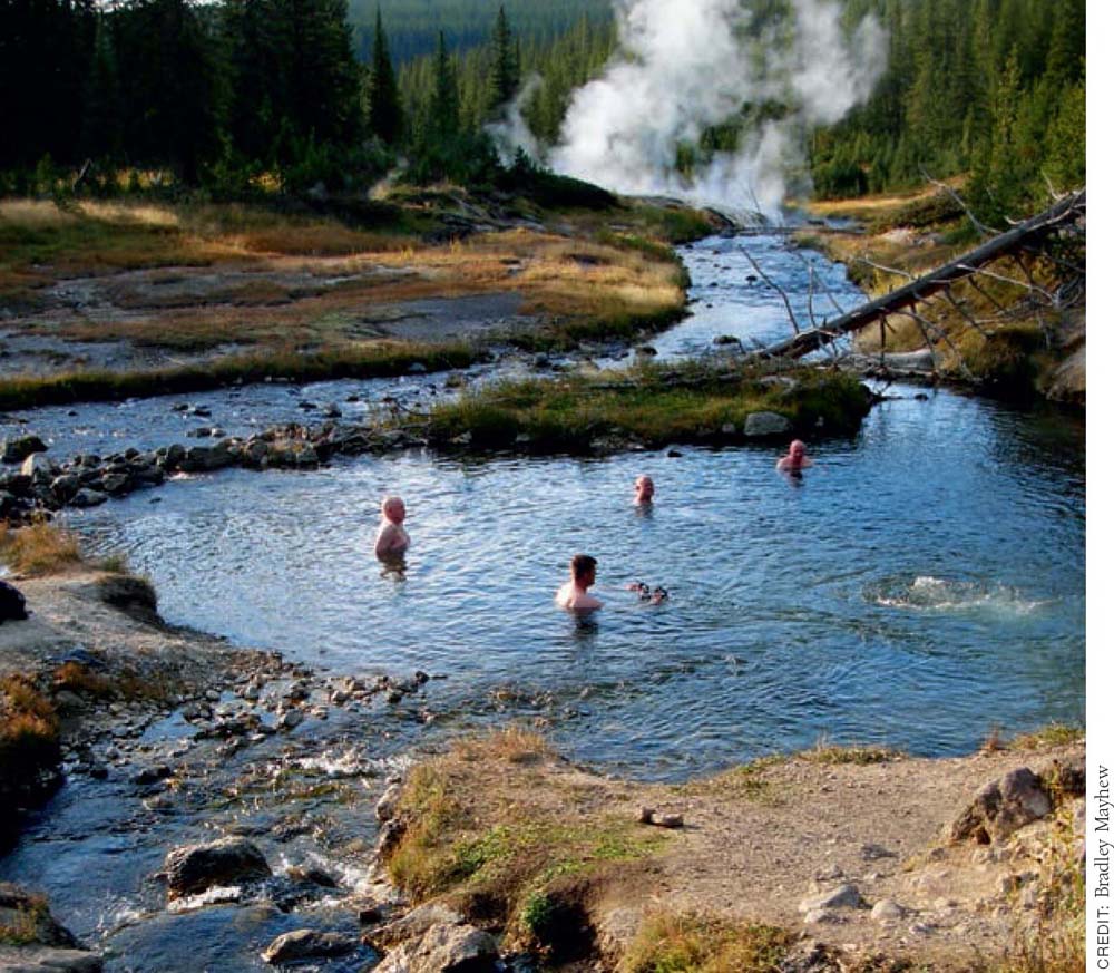
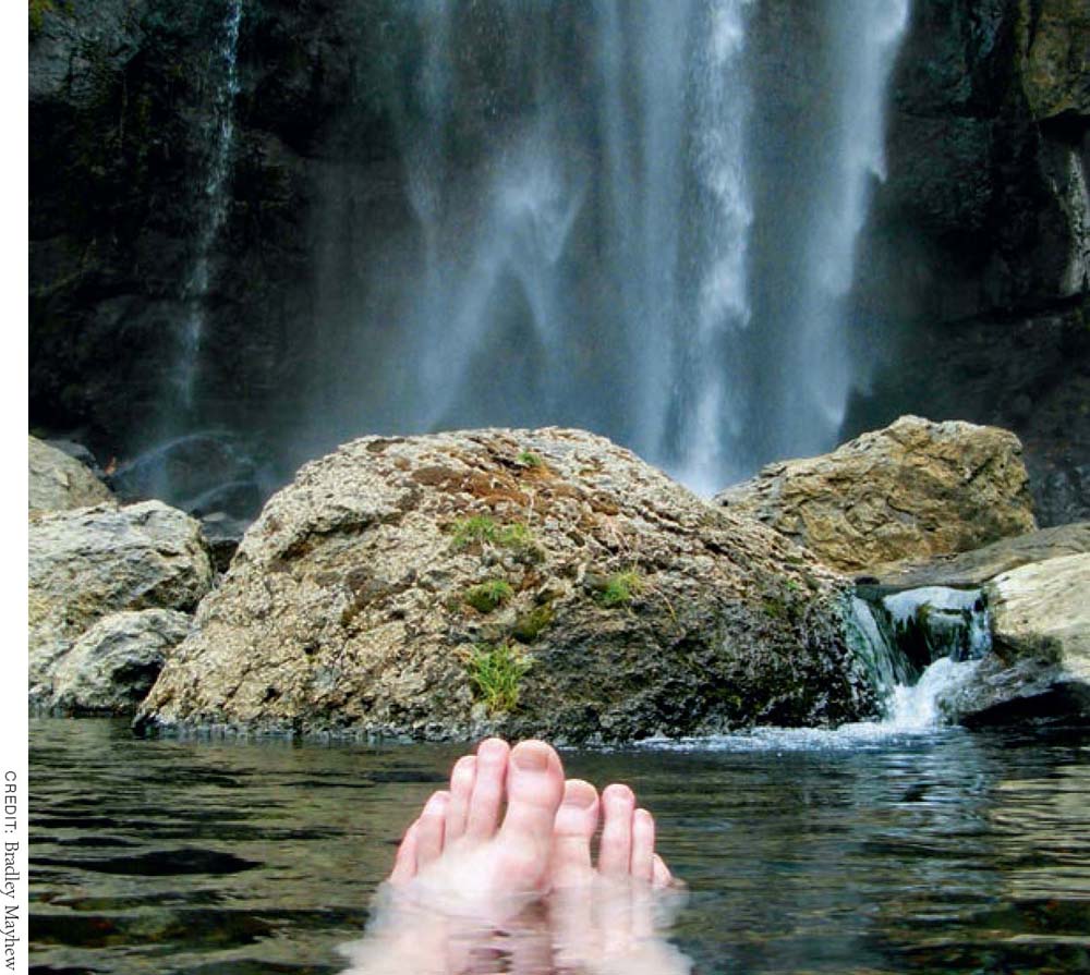
The trail descends gradually through lush, unburned forest, along the east side of the Gregg Fork for another 1.5 miles to a typically unsigned (but well-beaten) 0.5-mile side trail that heads east (left), past a hitch rail and upstream along the north bank of the Ferris Fork. The main attraction here is the huge, circular hot-spring soak known as “Mr. Bubbles,” which easily ranks as the park’s finest backcountry soak, but there are also several hot springs and calcite terraces that warrant exploration. Intrepid bushwhackers may discover several seldom-seen waterfalls upstream.
Camping
Back on the main route, the trail switchbacks down across the Gregg Fork, past 45-foot Ragged Falls to the ideal campsite 9D1, ▸14 (no wood fires) perched above Three River Junction, the captivating confluence of the Phillips, Gregg, and Ferris Forks, forming the headwaters of the Bechler River. The Three Rivers Patrol Cabin ▸15 and stock-party campsite 9B0 (two-night limit, no wood fires) are a mile below the junction, in a meadow riddled with algae-laden thermal features.
Waterfall
The better overnight option, campsite 9B9 (two-night limit, no wood fires), awaits a few hundred yards downstream, tucked away on the left side of the trail below the towering Batchelder Column. ▸16 The impressive, roaring, 260-foot Albright Falls cascade is visible (and audible) from the stellar campsite. Fishing can be good below the falls.
A mile downstream, the trailside campsite 9B8 ▸17 (with a pit toilet) is below a patch of burned forest, just before the first of two substantial fords of the Bechler River. Orange blazes usually mark the best places to cross, but don’t hesitate to scout upstream and downstream options if you don’t like the looks of things where the trail hits the water.
Hikers enjoying the remote hot spring waters of Mr. Bubbles
Another mile down-canyon, just after a more serious 50-foot-wide ford (up to hip-deep in August), is campsite 9B7, ▸18 set back well off the trail, up against the sheer canyon walls.
Canyon 
There’s plenty more mud here, as cold feeder streams tumble across the trail. Less than a mile downstream is the nice trailside campsite 9B6. ▸19 The trail gets a bit steeper and rockier as it approaches the first of several cascades above the forested Treasure Island islet, in the middle of the river. To your left in the wet season, a series of unnamed cataracts plunge down from the Pitch-stone Plateau.
The damp, less desirable campsite 9B5 ▸20 is between the 40-foot, rainbow-producing Iris Falls and the spectacular, two-tiered Colonnade Falls, ▸21 which is visible from a signed, 300-yard side trail that dead-ends at a viewpoint and picnic spot.
Viewpoint 
The lower stretch of trail alternates between meadows, fir–spruce forest, and boulder fields festooned with edible raspberries, huckleberries, and thimbleberries. Angler alert: A couple of miles downstream, just before leaving the canyon, there’s an opportunity to bushwhack up to your left—to Ranger Lake, where rainbow trout are rumored to lurk.
At 230 feet, Ouzel Falls is one of Yellowstone’s tallest cascades, though it’s hardly the most impressive. It’s most striking early in the season, as it loses much of its oomph by the end of August.
At the mouth of Bechler Canyon, trailside campsite 9B4 ▸22 awaits below Ouzel Falls, which is 0.5 mile north of the trail and visible for miles around.
Less than a mile farther along, fronting the eastern edge of the vast meadows, campsite 9B3 ▸23 (two-night limit) is reserved for stock parties. The popular trailside campsite 9B2 ▸24 (two-night limit, no wood fires) is just before the knee- to thigh-high Bechler River ford, 5.7 miles from the exit trailhead.
Depending on the season and water level, you can opt to turn left here and stay on the east side of the Bechler River for a slightly longer but more scenic route back to the ranger station, via the wider but shallower Rocky Ford.
Our route continues straight ahead beyond the Bechler River ford. It passes the 9M2 stock campsite (two-night limit, no wood fires) before crossing a boggy section on a footbridge, just before the signed Bechler Meadows Cutoff Trail junction. ▸25
Again, depending on the season and prevailing conditions, it can be a soggy slog for the next 1.5 miles through the wildlife-rich meadows to the Boundary Creek suspension bridge. ▸26
Camping
Just beyond Boundary Creek is the exposed trailside campsite 9B1. ▸27 Keep straight on the Bechler Meadows Trail as the alternate River Trail rejoins from the left, unless you have reserved the riverfront campsite 9C1 (two-night limit) 0.5 mile downstream (to your left at the junction). After a long stretch across a forested upland island, stay left at the Boundary Creek Trail junction. ▸28 From here, it’s 1.6 miles to a signed junction ▸29 and, finally, the pit toilets and drinking-water spigot near the Bechler Ranger Station. ▸30
▸1 0.0 Start at Lone Star trailhead
▸2 1.6 Right at Spring Creek Trail junction
▸3 2.5 Lone Star Geyser
▸4 2.7 Left at Shoshone Lake Trail junction
▸5 2.9 Campsite OA1
▸6 3.3 Campsite OA2
▸7 4.1 Campsite OA3
▸8 6.0 Grants Pass
▸9 6.4 Right at Bechler River–Shoshone Lake Trail junction
▸10 9.5 Campsite 9D4
▸11 10.7 Campsite 9D3
▸12 12.0 Douglas Knob
▸13 13.5 Campsite 9D2
▸14 15.9 Three River Junction and campsite 9D1
▸15 16.8 Three Rivers Patrol Cabin and campsite 9B0
▸16 17.0 Campsite 9B9 and Batchelder Column
▸17 17.9 Campsite 9B8
▸18 18.9 Campsite 9B7
▸19 19.6 Campsite 9B6
▸20 20.8 Campsite 9B5
▸21 20.9 Colonnade Falls
▸22 22.6 Campsite 9B4
▸23 23.3 Campsite 9B3
▸24 24.0 Campsite 9B2 and Bechler River ford
▸25 24.5 Left at Bechler Meadows Cutoff Trail junction
▸26 26.0 Boundary Creek suspension bridge
▸27 26.3 Straight on Bechler Meadows Trail past campsite 9B1
▸28 28.0 Left at Boundary Creek Trail junction
▸29 29.6 Straight to Bechler Ranger Station
▸30 29.7 Arrive at Bechler Ranger Station parking area
TRAIL 26 SOUTHWEST YELLOWSTONE
Cave Falls and Bechler Falls
TRAIL USE
Hike, Horse
LENGTH
7.3 miles, 2.5–3 hours
VERTICAL FEET
Negligible
DIFFICULTY
− 1 2 3 4 5 +
TRAIL TYPE
Loop
SURFACE TYPE
Dirt
FEATURES
Child Friendly
Stream
Waterfall
Autumn Colors
Birds
Wildlife
Photo Opportunity
Swimming
FACILITIES
Ranger Station
Restrooms
Picnic Tables
Horse Staging
Wider than they are tall, Bechler and Cave Falls are the most accessible cascades in the remote Bechler region. This easy loop provides a sample of what the area has to offer while avoiding river fords.
Best Time
Runoff is highest from May on, but access to the region is difficult, and trails remain wet and muddy until mid-July. Of course, by the time the trails have dried out in August and September, the volume of the waterfalls is greatly diminished. Throughout October, the weather can be good but is very unpredictable.
Finding the Trail
From the West Entrance at West Yellowstone, Montana, head south 60 miles (1.5 hours) on US 20 to Ashton, Idaho. Turn east on ID 47 for 6 miles, past Marysville, and just after the road jogs to the left take a right onto Cave Falls Road. Continue 17 miles, past the Idaho–Wyoming state line, and then turn left for the Bechler Ranger Station at the signed junction for Cave Falls.
An alternate but very rough route from Yellowstone’s South Entrance heads 50 miles west from Flagg Ranch to a cutoff for the Bechler Ranger Station via the unpaved Grassy Lake Road (called Ashton–Flagg Ranch Road, Reclamation Road, or USFS Road 261 on some older maps).
From the day-hiking parking area near the Bechler Ranger Station, ▸1 look just south for the South Boundary Trail trailhead. ▸2 The trail heads out southeast through lodgepole pines on a different route than the other trails that leave from the northwest side of the barn.
South of the park, below the Cave Falls Campground, the Fall River features a 14-mile, Class III whitewater kayak run through prime grizzly bear and bald eagle habitat.
There’s an easy ford of Wyoming Creek 0.5 mile from the trailhead, after which the trail parallels the park’s southern boundary and paved Cave Falls Road for a mile. After passing the U.S. Forest Service Cave Falls Campground on the opposite side of the road, ▸3 the trail enters the Cave Falls parking lot and picnic area at the end of the road, 3.8 miles from the trailhead. ▸4
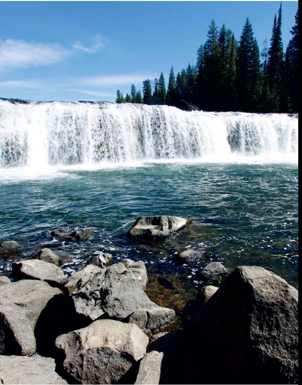
Waterfall
Cave Falls’ name comes from the large cavern near its base on the river’s west bank. Depending on the flow of the wide, two-tiered plunge, it’s sometimes possible to wade upstream and swim near the base of the falls.
Swimming 
Beyond the falls, the trail continues upstream 0.2 mile along the west side of the Fall River past some rapids to the Bechler River confluence. ▸5 Less than a mile farther upstream, Bechler Falls ▸6 cascades over 15 feet. The understory vegetation here is a lush mix of mosses, ferns, and thickets of berry bushes beneath a crowded spruce–fir canopy. Monitor the banks above the river for moose, deer, and other berry-loving browsers.
Wildlife
The trail leaves the river a mile beyond the falls at the Bechler River Cutoff Trail junction, ▸7 where it loops back around through unburned forest to the Bechler Ranger Station parking area. ▸8
Above Cave Falls, the cutthroat and rainbow trout get bigger, and upstream the fishing gets better the farther you hike off-trail. Aquatic insects begin to hatch in July.
Cave Falls can be reached by foot or car and makes for a nice picnic spot.
CREDIT: Bradley Mayhew
▸1 0.0 Start at Bechler Ranger Station trailhead
▸2 0.1 Southeast on South Boundary Trail
▸3 2.8 Straight past Fall River ford parking area
▸4 3.8 Cave Falls overlook and picnic area
▸5 4.0 Bechler River–Fall River confluence
▸6 4.8 Bechler Falls
▸7 5.8 Left at Bechler River Cutoff Trail junction
▸8 7.3 Return to Bechler Ranger Station parking area
OPTIONS
Save the Best for Last?
The loop can be done in either direction with no change in difficulty. As described, the route leaves the best for the second half of the hike. You can cut out the part along the road by doing the trip clockwise and turning around at either Bechler or Cave Falls and retracing your steps.
Alternatively, you can start at the Cave Falls trailhead parking area and do an easy 2-mile, one-hour out-and-back jaunt to Bechler Falls.
TRAIL 27 SOUTHWEST YELLOWSTONE
Dunanda Falls and Silver Scarf Falls
TRAIL USE
Hike, Backpack, Horse
LENGTH
16.4 miles, 8–10 hours
VERTICAL FEET
±400
DIFFICULTY
− 1 2 3 4 5 +
TRAIL TYPE
Out-and-back
SURFACE TYPE
Dirt
FEATURES
Backcountry Permit
Stream
Waterfall
Autumn Colors
Birds
Wildlife
Photo Opportunity
Camping
Swimming
Secluded
Geothermal
FACILITIES
Ranger Station
Restrooms
Water
Horse Staging
Highlights include lush riparian zones; vast, wildlife-rich meadows; sublime hot pots; invigorating stream crossings; and mesmerizing waterfalls. Because there are several good campsites en route, the trip is easily extended into a moderate overnighter.
Best Time
The Bechler is wet and buggy through the end of July. River fords can be tricky and run high until mid-July, but waterfalls are at their most spectacular early in the season. August and September are the classic times to hike the Bechler. October is bug-free and can be glorious or a real boondoggle if an early winter storm sweeps through. The lowest-lying parts of the trail can be swampy year-round. Definitely bring your hiking sandals or wading shoes, plus trekking poles for added stability.
Finding the Trail
From the West Entrance at West Yellowstone, Montana, head south 60 miles (1.5 hours) on US 20 to Ashton, Idaho. Turn east on ID 47 and travel 6 miles, past Marysville, then jog right onto Cave Falls Road. Continue 17 miles, past the Idaho–Wyoming state line, and then turn left for the Bechler Ranger Station at the signed junction for Cave Falls.
An alternate but very rough route from Yellowstone’s South Entrance heads 50 miles west from Flagg Ranch to a cutoff for the Bechler Ranger Station via the unpaved Grassy Lake Road (called Ashton–Flagg Ranch Road, Reclamation Road, or USFS Road 261 on some older maps).
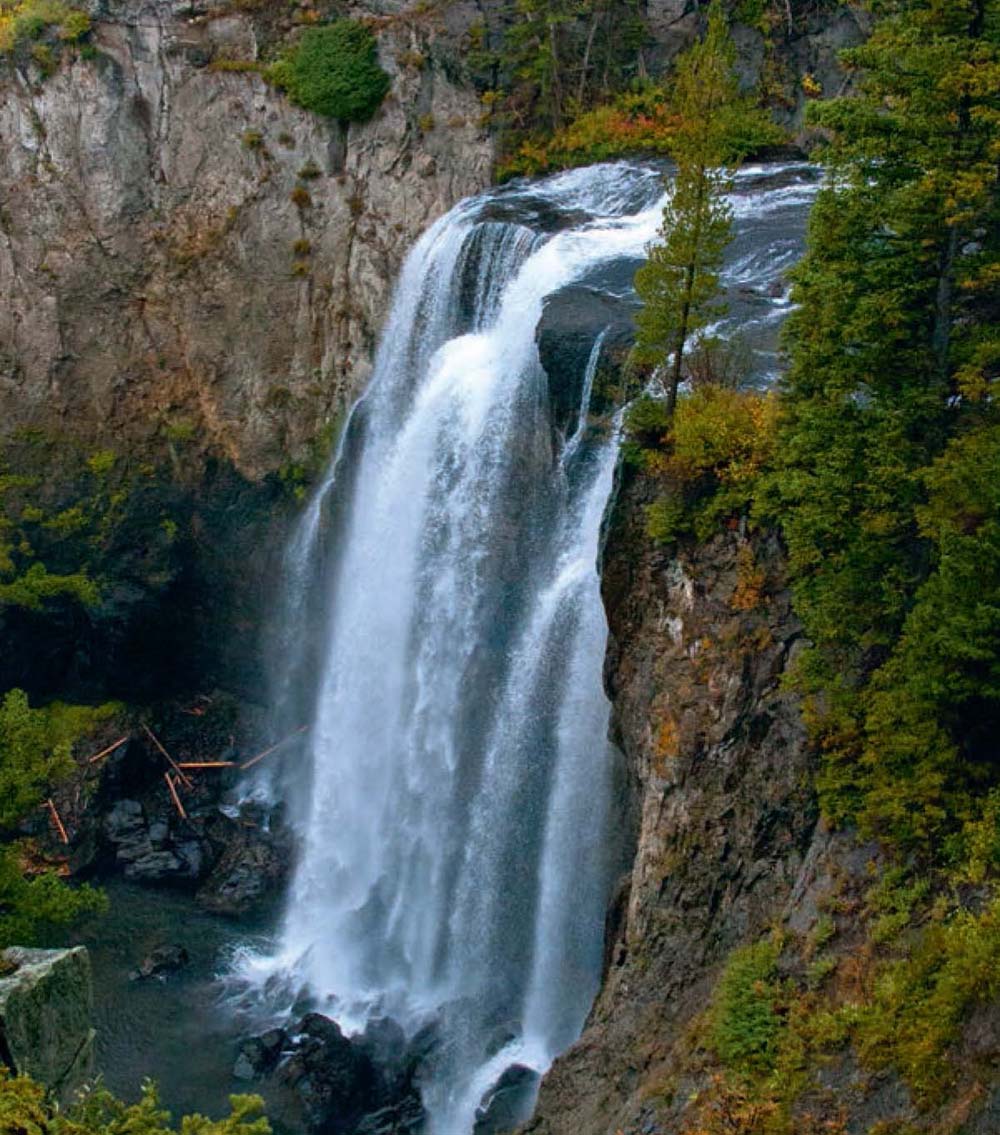
View of Dunanda Falls from the overlook
Trail Description
From trailhead 9K1 between the barn and the Bechler Ranger Station, ▸1 head north into unburned upland islands of lodgepole pine forest. Just beyond the Bechler Meadows Trail junction, ▸2 the trail crosses a rotting boardwalk (it may have been replaced by the time you read this).
Dunanda, the name of the 150-foot plunge, comes from the Shoshone word for “straight down.” For a sample of the Cascade Corner’s varied delights, this rewarding, daylong hike can’t be beat.
At 1.6 miles from the trailhead, fork left onto the Boundary Creek Trail, ▸3 which continues north past several ponds and through small, marshy meadows. The forest thins out a bit as the trail crosses several boggy areas on logs.
Wildlife
As you approach the southern edge of the flat expanse of Bechler Meadows, you’ll have to wade through the stagnant, murky Bartlett Slough. Early in the season it can be difficult to see the solid bottom, but by August it is usually a shallow crossing and, if you’re lucky, may be bridged by logs. On the upside, there are good views of the Tetons in the background, and the surrounding territory is prime moose stomping grounds.
Camping
Trailside campsite 9A1, situated in a mature island of lodgepole pine overlooking the meadows, receives heavy stock use and is a hundred yards before the Boundary Creek ford, ▸4 5 miles from the trailhead. The crossing here can be knee- to thigh-high, even after the water level drops in July. Late in the season, the creek may be serendipitously bridged by deadfall. Things only get damper as you head upstream between the edge of the forest and the east bank of Boundary Creek. Scan the meadows for great blue herons and sandhill cranes.
Birds 
Camping
At 6.4 miles, campsite 9A0 is another popular stock site, on the opposite bank of a Boundary Creek tributary, just beyond the Bechler Meadows Cutoff Trail junction. ▸5 You’ll encounter several small, unbridged fords in the next mile—most should be crossable on fallen logs. Beyond a small ford and the nice hiker-only campsite 9A2, in the middle of a large meadow, the trail traverses a decade-old burn area.
OPTIONS
To Ford or Not to Ford?
By adding 0.6 mile in each direction, you can avoid the ford of Boundary Creek: On your way to the falls, stay on the Bechler Meadows Trail at the Boundary Creek Trail junction, and then turn left on the Bechler Meadows Cutoff Trail to rejoin the Boundary Creek Trail. There’s no guarantee, however, that the trail through Bechler Meadows will be any less wet than the fords. It’s always a good idea to check current ford and trail conditions at the Bechler Ranger Station before heading out. By taking this route in one direction, you get a loop hike that avoids too much repetition and adds only 0.6 mile.
Overnight Options
Few backpackers (and even fewer day hikers) venture upstream above Dunanda Falls on the Boundary Creek Trail. The trail traces Boundary Creek as it climbs several hundred feet past solitary campsite 9A4 and several intriguing thermal areas. Eventually it ends up at fishless Buffalo Lake, 1 mile east of the park’s western boundary.
If you can score a campsite reservation, there are many good options for extending the trip overnight.
Waterfall
A short spur trail to the hiker-only campsite 9A3 joins the main trail just before the Silver Scarf Falls junction, ▸6 8 miles from the trailhead. The campsite is within earshot of Dunanda Falls and is a great base camp for exploring nearby hydrothermal wonders. It’s worth exploring nearby cascades of Silver Scarf Falls.
The Dunanda Falls overlook ▸7 is just beyond the final junction, a few hundred yards up the trail’s left fork.
Geothermal
After exploring off-trail around the brink of the falls, it’s a simple matter of relaxing in one of the popular riverside hot pots, formed where hot springs mix with cool river water. It’s a delicious sensation to feel the cold spray of the waterfalls on your face as the rest of you soaks in bathtub-temperature waters. Eventually you’ll have to pull yourself away from the hot pots before retracing your steps back to the Bechler Ranger Station. ▸8
▸1 0.0 Start at Bechler Ranger Station trailhead
▸2 0.1 Left at Bechler Meadows Trail junction
▸3 1.6 Left at Boundary Creek Trail junction
▸4 5.0 Campsite 9A1 and Boundary Creek ford
▸5 6.4 Left at Bechler Meadows Cutoff Trail; campsite 9AO
▸6 8.0 Left at Silver Scarf Falls spur trail junction
▸7 8.2 Dunanda Falls overlook
▸8 16.4 Return to Bechler Ranger Station parking area
Soaking in hot springs at the base of Dunanda Falls
TRAIL 28 SOUTHWEST YELLOWSTONE
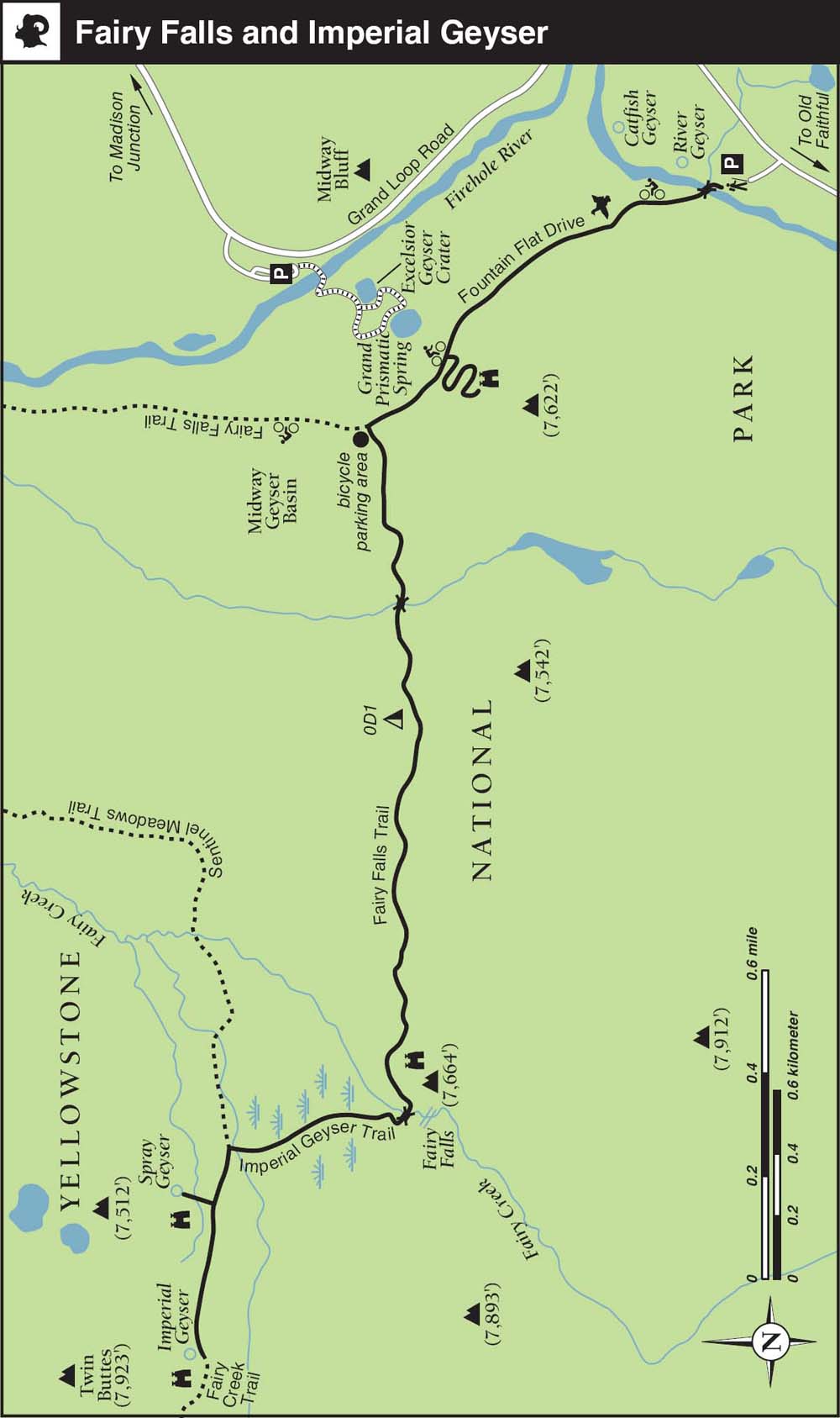
Fairy Falls and Imperial Geyser
TRAIL USE
Hike, Bike, Backpack
LENGTH
5.2 miles (6.8 miles including Imperial Geyser), 2–3.5 hours
VERTICAL FEET
Negligible
DIFFICULTY
− 1 2 3 4 5 +
TRAIL TYPE
Out-and-back
SURFACE TYPE
Dirt
FEATURES
Child Friendly
Waterfall
Wildflowers
Birds
Great Views
Photo Opportunity
Camping
Swimming
Geothermal
FACILITIES
None
This family-friendly day hike epitomizes what’s so wonderful about the Yellowstone backcountry. Just a short distance off the road, you’ll find one of the park’s tallest waterfalls and a couple of intriguing, seldom-seen geothermal features. It’s a jeans-and-tennis-shoes sort of picnic outing; you can even cycle part of the way.
Best Time
Fairy Falls is at its most spectacular in spring, and the trail is normally hikable from the end of May to October. There’s little shade and no water along the trail, except at the falls. Head out early to dodge the crowds and avoid the midday heat. The entire surrounding Firehole area, including Firehole Freight Road and Firehole Lake Drive, is closed for bear management from March 10 through the Friday of Memorial Day weekend.
Finding the Trail
From the south, go 4.3 miles north from the Old Faithful overpass on Grand Loop Road and turn left into the Fairy Falls (also known as Steel Bridge) trailhead parking area, on the west side of the road. This is a very popular trailhead, so get here early to snag a parking spot. From the north, head 11.2 miles south from Madison Junction on Grand Loop Road, 1.4 miles past the Midway Geyser Basin turn-off, and turn right into the busy parking area.
View of Grand Prismatic Spring from the viewpoint above Fountain Flat Drive
Logistics
Check at the Old Faithful Visitor Center or call rangers at 307-344-2750 to ask about recent Imperial Geyser activity before heading out. Rangers lead Adventure Hikes to Fairy Falls and Imperial Geyser June–August on Thursdays at 8 a.m. Check the park newspaper for details.
From the trailhead parking area, ▸1 the wide, gravel Fountain Flat Drive (originally known as National Park Avenue) starts on the other side of an old steel trestle bridge ▸2 that spans the Firehole River. This stretch of the Firehole is a popular catch-and-release fishing access point. The first section of the trail skirts several riverside thermal features. The road itself is popular with bicyclists heading to the Fountain Flat Drive trailhead, 3.5 miles north. If you are short on time, consider cycling to the turnoff to Fairy Falls and begin hiking from there, shaving 2 miles off the walk.
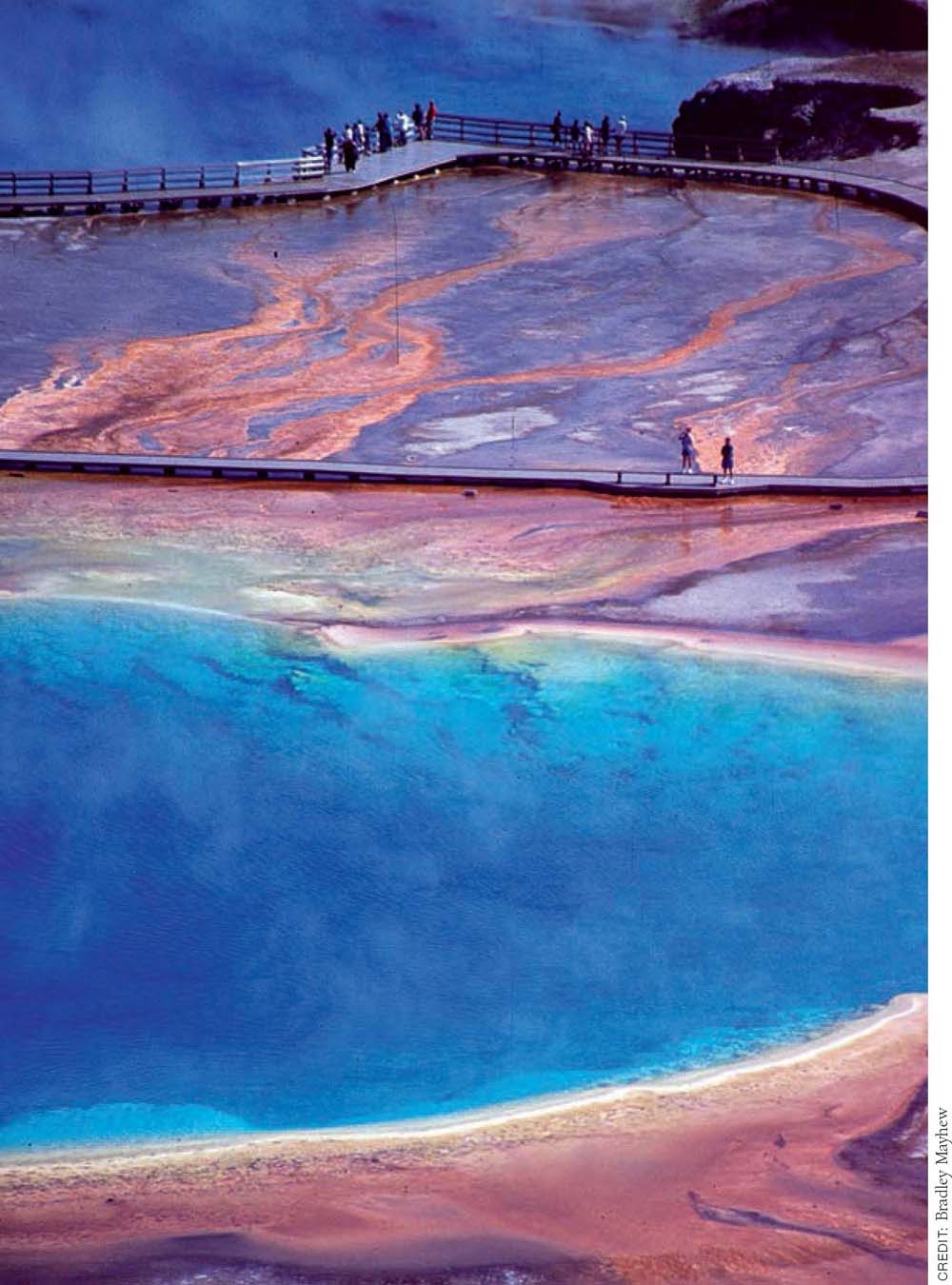
Grand Prismatic Spring is one of the world’s largest hot springs, comparable in size to Deildartunguhver in Iceland but smaller than the geothermal complex in New Zealand’s volcanic Waimangu Valley.
Birds
As the trail swings away from the river, look for ducks and geese in the ponds and marshes to your right. Signs of the 1988 fires abound in the open meadows and on the denuded hillsides. Straight ahead, look for the steam rising from the Midway Geyser Basin.
Photo Opportunity 
Geothermal
Viewpoint
Before you come level with Grand Prismatic Spring after 0.6 mile, you’ll see its huge, marshy runoff field. Notice how the steam reflects the rainbow colors of the spring, which are especially visible with polarized sunglasses. You can get some idea of the vibrancy and immensity of the awe-inspiring spring as the trail skirts the Midway Geyser Basin, but the best views are from the hills to your left. Hikers have long climbed unofficial trails up the hillside here, and in 2016 the park service decided to construct a formal trail up the hillside, spurred to action after a falling tree killed a Taiwanese hiker the year before. The new trail climbs a few hundred feet to offer one of the park’s newest and greatest viewpoints. ▸3 Only from this height can you truly appreciate the rainbowlike multicolored bands ringing Grand Prismatic Springs.
Back on the main trail, after 1 mile, just beyond the geyser basin, the trail joins the Fairy Falls Trail (bicycles not allowed, so park yours at the junction). ▸4 Turning left, the trail enters an alley of regenerating lodgepole pines, already well over head height. You are also in the heart of the Firehole Bear Management Area, so keep your wits about you, and obey any posted signs.
Camping
You soon cross a wooden footbridge over a stream coming out of a small, unnamed lake before reaching the well-signed 0D1 campsite ▸5 turnoff at 1.7 miles. The campsite is a few hundred yards north of the trail, in a small island of mature lodge-pole pines that survived the 1988 fires. It’s also less than an hour from the trailhead, a good overnight option for families and first-time backpackers—but there’s no water, and shade is sparse.
Wildflowers 
Beyond the OD1 spur trail junction, the main trail does a few gentle ups and downs as it hugs the base of the ridge to your left. You soon start to see signs of forest diversification, including some wild-flowers and quaking aspen saplings. Check out the twisted, gnarled branches on some of the remaining snags. Stop for a moment: Can you hear the falls reverberating off the base of the hills? Straight ahead, the Twin Buttes loom, bald as eagles.
Waterfall
As you turn the corner to Fairy Falls, ▸6 2.6 miles from the trailhead, you’ll notice how the mist from the falls makes the lush vegetation dramatically different. With a drop of almost 200 feet, it’s the tallest frontcountry waterfall in Greater Yellowstone. You can catch a brisk shower if the weather is particularly hot. The area just downstream from the falls, where raspberries shoot up between the rocks, makes a nice picnic spot (shade or sun; take your pick).
OPTIONS
Imperial Geyser and Twin Buttes
The round-trip to Imperial Geyser adds 1.6 miles, negligible elevation gain, and about an hour, depending on how much of a geyser-gazer you are. From the geyser basin, you can continue north off-trail 0.5 mile to summit the Twin Buttes and get a good overview of the Lower and Midway Geyser Basins.
Hikers walk around Grand Prismatic Spring with fire-scarred hillsides beyond.
Geothermal
From the falls, you can either retrace your steps to the trailhead or forge ahead 0.8 mile to a couple of seldom-seen geysers for the unchoreographed antithesis of the Old Faithful experience. If you decide to press on, a trail sign for the Imperial Geyser Trail, ▸7 just beyond the bridge, points the way. It’s 0.4 mile from the falls to a junction with the Sentinel Meadows Trail, ▸8 then a few hundred yards more to the geyser basin.
Cross a couple of long boardwalks that span damp meadows. These boardwalks may be closed to stock use. If the buffalo chips atop the walk-way are any indication, apparently the bison are impervious to National Park Service management directives. From the middle of the second board-walk, look for a steam plume off to your left. The broad trail wends its way past more aspen saplings as it heads toward the Twin Buttes. Watch here for black beetles and other winged insects that colonize burn areas after fires.
Geothermal
At the final unsigned junction, ▸9 the right fork crosses a thermal runoff channel full of orange and green thermophile strands and mats. If possible, please use the logs to cross, and tread carefully to preserve the fragile microbiology. Solitary Spray Geyser is a near-perpetual spouter, erupting frequently to a height of 6–8 feet.
Photo Opportunity
Retrace your steps to a game trail that follows the runoff channel upstream through several bison wallows to reach Imperial Geyser, ▸10 which erupts frequently.
If you approach the sulfurous mud kettles around the back side of the geyser basin, take great care in the fragile area, and listen to the belching sounds for clues about how the basin’s plumbing is connected.
Follow the trail downstream along the far side of the runoff channel to retrace your steps. Turn right at the Imperial Geyser Trail junction to return to the Fairy Falls trailhead parking area. ▸11
 MILESTONES
▸1 0.0 Start at Fairy Falls trailhead
▸2 0.1 Cross Firehole River on Soldier Bridge
▸3 0.6 Climb new trail to viewpoint
▸4 1.0 Left at Fairy Falls Trail junction
▸5 1.7 Straight past campsite 0D1 spur trail
▸6 2.6 Fairy Falls
▸7 2.8 Left at Imperial Geyser Trail junction
▸8 3.0 Left at Sentinel Meadows Trail junction
▸9 3.2 Right at unsigned fork to Solitary Spray Geyser
▸10 3.4 Right upstream to Imperial Geyser
▸11 6.8 Return to Fairy Falls parking area
TRAIL 29 SOUTHWEST YELLOWSTONE
Lone Star Geyser
TRAIL USE
Hike, Bike, Backpack
LENGTH
5.0 miles, 2.5–3 hours
VERTICAL FEET
Negligible
DIFFICULTY
− 1 2 3 4 5 +
TRAIL TYPE
Out-and-back
SURFACE TYPE
Paved
FEATURES
Child Friendly
Handicap Accessible
Stream
Wildlife
Cool & Shady
Photo Opportunity
Camping
Geothermal
Moonlight Hiking
FACILITIES
Restrooms
It’s an easy stroll along an abandoned road to one of the park’s most impressive and dependable geysers. The hike is justifiably popular with tour groups, and you might see a few backpackers heading out for the Bechler River Trail, which begins a day’s hike down-trail, beyond Shoshone Lake. The trail also offers one of the park’s few opportunities for a 10- to 15-minute, traffic-free bike ride on a paved road to the geyser. Allow at least an hour for the hike so you don’t miss the eruption.
Best Time
Lone Star is a popular year-round destination, even in winter. Eruptions take place every three hours or so, meaning you could wait up to three hours for an eruption if your timing is off. If you have time to kill, consider exploring the trail headed toward Shoshone Lake, which has some interesting thermal features not far from Lone Star Geyser.
Finding the Trail
From the Old Faithful overpass, head 2.5 miles south on Grand Loop Road, and turn right into the trailhead parking lot on the south side of the road. From the southeast, go 14.5 miles west over Craig Pass (8,262 feet) from West Thumb and turn left into the parking lot. The trailhead is just south of the Kepler Cascades turnout, which is a parking alternative if the Lone Star lot is full.
Rangers lead 4.5-hour hikes here in the summer every Tuesday at 8 a.m. when budgets allow; check the park newspaper for the current schedule. Regular eruptions happen about every 3 hours, with minor eruptions around 30 minutes before the main event. Splashing preplay starts up to an hour before eruptions, and there’s a noisy steam phase afterward.
Trail Description
From the parking lot, ▸1 the trail starts out on a flat, abandoned service road just upstream from the Kepler Cascades. The traffic noise from Grand Loop Road quickly fades as birds twittering, chipmunks chattering, and the rush of the Firehole River take over. If you stop to listen and use your imagination, the wind here might sound like the ocean whistling through the trees.
After a few hundred yards, check out the old waterworks ▸2 on the right, where the trail joins the Firehole River. The road becomes asphalt as the trail traces the east bank of the river upstream. Mature mixed-conifer forest surrounds the route on all sides. There’s a dampness in the air and green mosses in the understory as the river passes under a bridge and calms upstream. Watch for steaming thermal features off-trail in the woods to the right. Note the saplings growing up through the roadbed.
Stay on the road where the Spring Creek Trail ▸3 joins in from the left after 1.6 miles. At 2 miles, follow the road as it jogs left at an abandoned service road. ▸4
Geothermal
You may hear Lone Star Geyser before you actually see it. During its steam phase between eruptions, it can be heard as far as a mile away. As the road ends, you’ll have to park your bike and walk the last short section. Less than a hundred yards after the road ends, ▸5 you’ll see the impressive, 12-foot-tall geyserite cone. ▸6 Major eruptions happen like clockwork, every three hours on average, with significant preplay in between. The eruptions can reach up to 45 feet and usually last 20–30 minutes. Check the National Park Service logbook near the bridge over the runoff channel to read reports and timings of recent activity.
Lone Star Geyser erupts roughly every three hours (Trails 25, 29, and 32).
Yellowstone’s Moonlight-Hiking Highlights
Full moonlight is the best time to explore the following favorites, but if you pack a flashlight or headlamp and stay alert for wildlife, most any boardwalk and geyser basin can be enjoyable to explore under a crescent moon.
• Mammoth Hot Springs (Trail 7) Boardwalks are fun to explore after dark from Liberty Cap side.
• Grand Canyon of the Yellowstone (Trails 14 and 15) The North and South Rims are best explored from the main parking areas near the Upper and Lower Falls and Inspiration and Artist Points. Take care when walking beside the canyon walls at nighttime.
• Norris Geyser Basin (Trail 19) The odds are steep, but you’ll never forget seeing a geyser like Steamboat erupt at night.
• West Thumb Geyser Basin (Trail 24) Super views of Yellowstone Lake; be alert for wildlife.
• Grand Prismatic Spring and Midway Geyser Basin boardwalks (Trail 28) Awesome steam shows.
• Lone Star Geyser (Trail 29) A unique opportunity to access a backcountry geyser via a paved road, which makes nighttime hiking slightly safer. Go with a good-size group, and make plenty of noise.
• Old Faithful and Observation Point (Trail 31) Essential if you’re staying at or near the geyser basin.
If you’re lucky enough to be camping out near an active back-country thermal area such as Shoshone Geyser Basin (Trail 32) during a full moon, then you should feel obligated to check out the natural phenomena—from a distance, mind you—by night as well as by day.
After the eruption, retrace your steps on the paved road back to the trailhead. ▸7
MILESTONES
▸1 0.0 Start at Lone Star trailhead/Kepler Cascades parking lots
▸2 0.2 Old Firehole River waterworks
▸3 1.6 Keep right at Spring Creek Trail junction
▸4 2.0 Keep left at abandoned service road
▸5 2.4 End of paved road; bicycle parking area
▸6 2.5 Lone Star Geyser
▸7 5.0 Return to parking area
OPTIONS
Howard Eaton Trail
You can avoid the crowds en route to Lone Star Geyser by starting out from the Old Faithful area at the Howard Eaton trailhead. The route—part of the Continental Divide National Scenic Trail—is actually less scenic and a bit longer (5.8 miles round-trip), which is why you should have it all to yourself.
Backcountry Camping
The three campsites just beyond Lone Star Geyser on the Shoshone Lake Trail are perfect places for a family to spend a first night in the backcountry. Campsite OA1 is 2.9 miles from the Lone Star trailhead; it allows stock parties. The hiker-only sites OA2 and OA3 are 0.4 and 1.2 miles farther along. All of these sites allow campfires but can be buggy in early summer.
TRAIL 30 SOUTHWEST YELLOWSTONE
Mystic Falls
TRAIL USE
Hike
LENGTH
4.0 miles, 2–3 hours
VERTICAL FEET
±500 to falls, ±1,000 for loop
DIFFICULTY
− 1 2 3 4 5 +
TRAIL TYPE
Loop
SURFACE TYPE
Boardwalk and Dirt
FEATURES
Child Friendly
Canyon
Stream
Waterfall
Wildflowers
Great Views
Photo Opportunity
Geothermal
Steep
FACILITIES
None
This day hike is popular thanks to its proximity to Old Faithful, and it offers easy access to a pretty backcountry cascade. Complete the full loop to leave the crowds behind and for an expansive overview of the Upper Geyser Basin.
Best Time
The flat, out-and-back option to the base of the falls is enjoyable any time May–October. Since there’s a lack of shade, on sunny days the full loop should be done outside of midday hours.
Finding the Trail
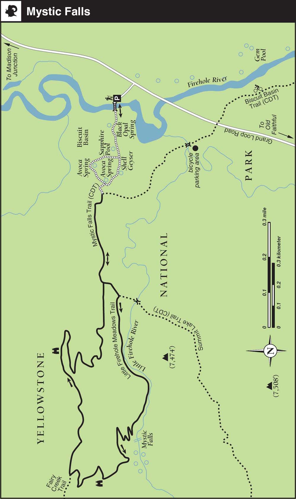
From the south, go 2 miles north on Grand Loop Road from the Old Faithful overpass and turn left into the Biscuit Basin Boardwalk parking area on the west side of the road. From the north, go 13.5 miles south from Madison Junction on Grand Loop Road and turn right. The Mystic Falls trailhead is across the Firehole River Bridge, on the far side of the boardwalk loop, 0.3 mile west of the parking lot.
Logistics
Rangers offer free, guided, 90-minute walks three times a week during summer; check the park newspaper for current schedules. Trips depart at 9 a.m. from the Firehole River Bridge, adjacent to the Biscuit Basin parking lot.
Here’s a tip: You can avoid parking hassles and enjoy a fun family bike ride by cycling the 2 miles from Old Faithful to Grand Loop Road near the trailhead via the Upper Geyser Basin Trail. Park your bike on the far side of Grand Loop Road, and start your hike from there.
More than a quarter of the world’s geysers are concentrated in the Upper Geyser Basin, which is home to about 150 spouting hydrothermal features.
Trail Description
Wildflowers
From the Biscuit Basin parking lot, ▸1 cross the Firehole River footbridge and follow the south side of the boardwalk loop ▸2 clockwise (left) past several notable geysers and hot springs. Before you reach Avoca Spring, watch for a wide, sandy trail ▸3 that heads off the boardwalk to your left, into the regenerating lodgepole pine forest. It’s often unsigned but usually marked by orange blazes. Wildflowers such as lupines, fireweed, and Indian paintbrush bloom prolifically here thanks to the 1988 fires.
Beyond the boardwalk, the nearly flat route—part of the Continental Divide National Scenic Trail—parallels the north side of the Little Firehole River. Stay left at 0.6 mile when the trail is met by the return loop of the Mystic Falls Trail. ▸4 You will return here in about an hour if you opt for the full loop.
Canyon
Waterfall
Soon after, head uphill (right) at the Summit Lake/Little Firehole Meadows Trail junction, ▸5 near the mouth of the Little Firehole River canyon; you’ve missed the turnoff if you cross the river on the footbridge. The trail climbs gradually up into the canyon above the north side of the river 0.5 mile to the base of Mystic Falls. ▸6 Steam and orange algae blooms indicate abundant thermal seeps in the runoff.
Steep 
While the multitiered, 70-foot cascade is enchanting from below, it’s best admired from above. You can either turn around here, making the hike an hour total, or continue the loop by climbing several hundred feet of switchbacks in a little less than a mile to a worthwhile overlook of Old Faithful and the Upper Geyser Basin.
Out-and-Back Picnic Option
The family-friendly, out-and-back option to the base of the falls involves 500 feet of elevation gain and takes a little over an hour round-trip. Figure on at least an extra half hour for a picnic and short climb to the top of the falls.
About 600 yards up the trail, there’s a nice overlook ▸7 near the top of the falls. The route continues climbing up through a regenerating lodgepole burn area to the Fairy Creek/Little Firehole Meadows Trail junction. ▸8
Viewpoint
Turn right, crest the ridge atop the Madison Plateau, and descend to the Biscuit Basin Overlook ▸9 for an impressive overview of the aftermath of the 1988 fires and the entire Upper Geyser Basin. With decent binoculars, you can enjoy a good bird’s-eye view of several major active geysers, including Old Faithful.
From the overlook, the trail descends via switch-backs more than 500 feet over 0.9 mile to rejoin the Mystic Falls Trail. ▸10 Fork left at the now-familiar junction and retrace your steps back through Biscuit Basin to the parking area. ▸11
MILESTONES
▸1 0.0 Start at Biscuit Basin trailhead parking lot
▸2 0.2 Left at boardwalk loop junction
▸3 0.3 Left at unsigned Mystic Falls Trail junction
▸4 0.6 Left at Mystic Falls Trail loop junction
▸5 0.65 Right at Summit Lake/Little Firehole Meadows Trail junction
▸6 1.2 Mystic Falls
▸7 1.5 Mystic Falls Overlook
▸8 1.7 Right at Fairy Creek/Little Firehole Meadows Trail junction
▸9 2.5 Biscuit Basin Overlook
▸10 3.4 Mystic Falls Trail junction
▸11 4.0 Return to parking area
TRAIL 31 SOUTHWEST YELLOWSTONE
Old Faithful and Observation Point
TRAIL USE
Hike
LENGTH
2.4 miles, 1.5 hours
VERTICAL FEET
±250
DIFFICULTY
− 1 2 3 4 5 +
TRAIL TYPE
Loop
SURFACE TYPE
Dirt
FEATURES
Child Friendly
Handicap Accessible
Steep
Great Views
Photo Opportunity
Geothermal
Moonlight Hiking
FACILITIES
Visitor Center
Restrooms
Picnic Tables
Phone
Water
For most folks, Old Faithful is a must-see. If you haven’t seen the most famous geyser in the world’s most active geyser basin, can you really say that you’ve been to Yellowstone?
Best Time
Any time of day or night is a wonderful time to see her majesty in action. The boardwalks are accessible year-round (weather permitting), while the loop trail is typically hikable May–October. Make sure to time your visit with an eruption (the average interval hovers around 90 minutes) by checking the predicted schedule with rangers at the visitor center. Or check the Web cam at tinyurl.com/oldfaithfulcam.
Finding the Trail
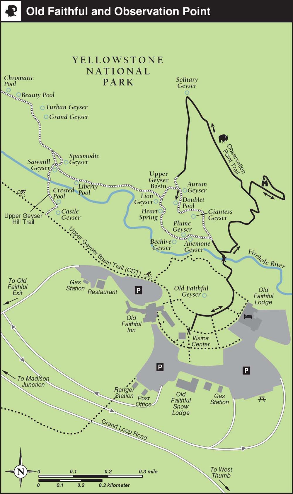
From the north, go south from Madison Junction on Grand Loop Road 15.5 miles to the Old Faithful exit. From the east, go 17 miles west from West Thumb on Grand Loop Road over Craig Pass (8,262 feet). After exiting from either direction, follow signs from the overpass for about a mile to the visitor center and Old Faithful geyser parking areas.
Logistics
The Old Faithful Visitor Center posts eruption prediction schedules for five major geysers (Castle, Daisy, Grand, Old Faithful, and Riverside) in the Upper Geyser Basin. Predictions are also made for Great Fountain, 8 miles north of Old Faithful off Firehole Lake Drive, in the Lower Geyser Basin. These predictions are also posted at Old Faithful’s lodgings and at the Madison Information Station, or call 307-344-2751 for recorded details.
Though probably Yellowstone’s most famous, Old Faithful is neither the largest nor the most regular geyser in the park. The largest active geyser in the world is Steamboat Geyser in the Norris Geyser Basin, erupting up to 400 feet in height (see Trail 19).
All predictions are estimates; Old Faithful’s performance intervals, for example, have varied historically from 45 to 120 minutes, with the current average time frame running 65–95 minutes.
If the next eruption is predicted (not scheduled!) for less than 30 minutes after you arrive, start the hike to Observation Point straightaway. Otherwise, grab a snack or drink, and check out the lobby of the inn or the visitor center’s displays and short films. In any case, allow at least 20–30 minutes for the short but aerobic climb to the overlook.
Trail Description
From the northwest side of the parking lot, ▸1 follow signs to the visitor center ▸2 and check the predicted eruption times so you can plan the best hiking strategy.
NOTES
Urban Legend
A group of bored seasonal employees once received a severe reprimand from the National Park Service after they engaged in a clever bit of street theater. A few minutes before Old Faithful was predicted to erupt, they rolled out a large red wagon wheel and pretended that they were cranking open the geyser’s subterranean plumbing so that the crucial H20 would appear, mocking visitors’ expectations of timeliness.
On Demand?
In the height of summer, it’s not uncommon to witness impatient crowds of spectators clapping in unison to urge the geyser on while complaining that their bus might leave if the darn thing doesn’t perform as “scheduled.”
Tours and Secrets of the Old Faithful Inn
The free guided tours of the inn are highly recommended, especially if you’re an architecture or history buff. The inn is exactly one-eighth of a mile from the geyser, the legal limit. Construction began in 1904 with a $140,000 loan from railroad magnates.
Architect Robert Reamer’s vision was to craft something that looked as if it had grown out of the surrounding landscape. Today, you’ll find a fire in the main lobby fireplace most mornings and evenings. Tuesday–Saturday evenings, longtime pianist George tickles the ivories on the mezzanine. Around the central fireplace, look for the massive blacksmithed popcorn poppers, which have been retired due to damage.
Notice how the lobby windows are staggered to simulate natural light streaming through a forest. The entire theme, in fact, is asymmetrical; Reamer abhorred symmetry. You can distinguish the original construction from newer additions by the pitch of the roof: the Old House has a steeply pitched roof, while the newer ones are much flatter. Five second-story rooms overlooking the main portico are favorites with large families because they are large (reserve well in advance) and offer nice geyser-basin views. Only 10 rooms in the original Old House have private bathrooms.
Today, bellhops are the only people who get to live in the inn full-time. Most live in the wing known as Bat’s Alley, where they have private bathrooms and enjoy the rooftop “pebble beach.” Even-numbered rooms in the Old House, 46–54, face Old Faithful, but increasingly lodgepole saplings are encroaching on the geyser views, and by law they are not allowed to be trimmed. A shared bathtub and showers are upstairs. Rooms 134 and 145 have private bathrooms. The smallest rooms, all with queen beds, still have original log walls. Construction of the east wing blocked views of Old Faithful that used to be enjoyed from the inn’s main dining room.
If you have a reservation at the inn, ask a bellhop if you can come along for the early-morning flag-raising ritual on the rooftop “widow’s walk” or in the evening when the flags are retrieved. Only two guests are allowed to join the bellhop for each shift. It’s a great photo op and includes a private tour of the historic inn’s otherwise off-limits Crow’s Nest.
From the visitor center, find the plastic-lumber boardwalk ▸3 circling Old Faithful, and follow it counterclockwise (right) for a few hundred yards. Branch right to leave the boardwalk at the signed turnoff for the Observation Point Trail, ▸4 which soon crosses the Firehole River on a wooden footbridge. ▸5
Old Faithful erupts dramatically.
What to Do Before an Eruption?
If you have time to burn before the next anticipated eruption, there are several intriguing options. The visitor center shows a film that gives a general introduction to the park, starting 30 minutes before an eruption is predicted. Another film about the inner workings of Old Faithful screens 15 minutes after each flare-up.
Or grab a drink from the bar or espresso cart on the mezza-nine level of the Old Faithful Inn and—if you can stand the diesel fumes from the idling buses—sit out on the deck and watch the geyser warm up. In the captivating lobby, pick up a self-guiding brochure from the front desk and check out the massive central fireplace and interior stylings of “parkitecture” pioneer Robert C. Reamer. Stairs in the rustic rafters shown above climb to the now off-limits “Crow’s Nest.”

Viewpoint
Soon after the bridge, head uphill to your right on the dirt path ▸6 where the left fork leads to the Geyser Hill boardwalk loop. A bit of hard breathing and 0.5 mile later, take the signed right fork of the Observation Point loop trail ▸7 up to the overlook ▸8 for an expansive panorama of the Upper Geyser Basin. Catch your breath, check your watch, and find a comfortable spot with an unobstructed view of the activity below.
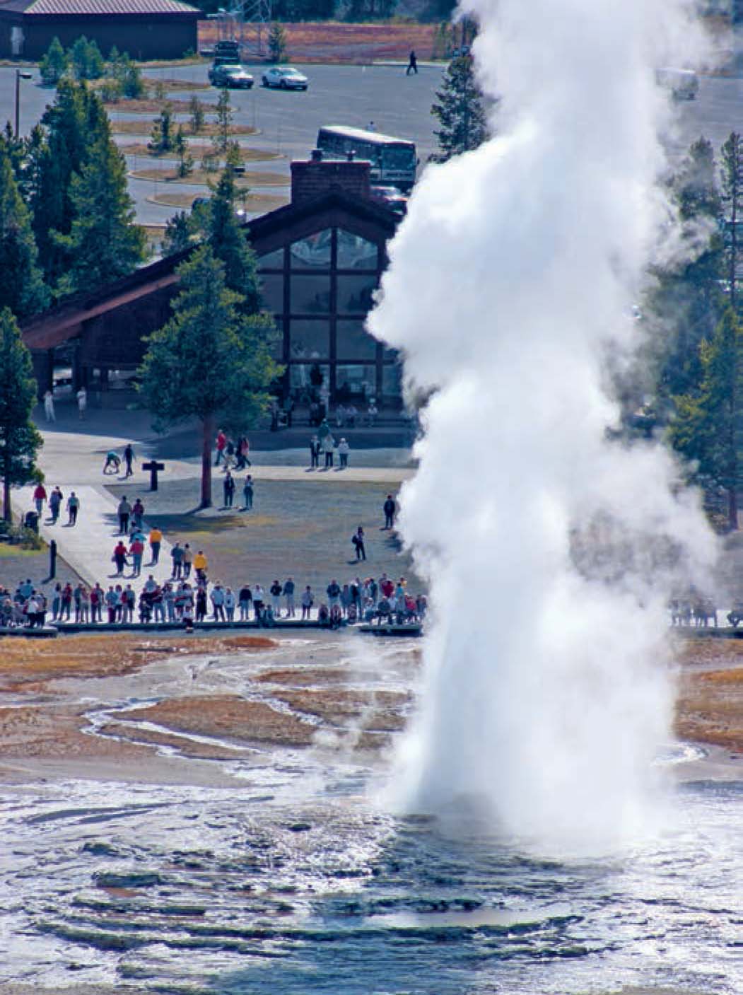
Named for its predictability by the Washburn Expedition in 1870, Old Faithful’s average interval between eruptions has lengthened due to earthquakes and vandalism, but it remains as predictable as it was more than a century ago. Its outbursts last anywhere from 90 seconds to 5 minutes, reach heights of 106– 184 feet, and expel 3,700–8,400 gallons of boiling water.
Heading back downhill, complete the Observation Point loop and turn right at the bottom of the hill. ▸9 Next, traverse 0.3 mile of mixed open forest—such good bear habitat that the trail is sometimes closed—to reach Solitary Geyser. ▸10 Solitary began its life as a hot spring but morphed into a gusher after its water was diverted for use in a swimming pool in the 1940s. Today, the ex-spring spouts up to 15 feet every four to eight minutes.
Head 0.3 mile downhill to the Geyser Hill board-walk ▸11 junction. The level, wheelchair-accessible boardwalk winds past named and unnamed active geysers, including several near-perpetual spout-ers. Interpretive signs and self-guided trail brochures explain some of the intriguing hydrothermal phenomena.
When you’re ready to conclude your hike, head back on the boardwalk toward Old Faithful. Where the Geyser Hill boardwalk ends, continue straight ahead on the paved walkway to return to the Fire-hole River footbridge. ▸12 Retrace your steps clockwise on the boardwalk ▸13 around Old Faithful—it may well be poised to erupt again—back to the visitor center ▸14 and parking lot. ▸15
OPTIONS
Geysers Galore
Unrepentant geyser-gazers who can’t get enough have plenty of exciting options for extending the hike from Old Faithful. It’s possible to follow a network of boardwalks and paved bike paths—part of the Continental Divide National Scenic Trail—northwest 2 miles, beyond Geyser Hill past the predictable Grand and Riverside Geysers (90 minutes–2 hours round-trip, including time for gazing), to the much-ogled Morning Glory Pool.
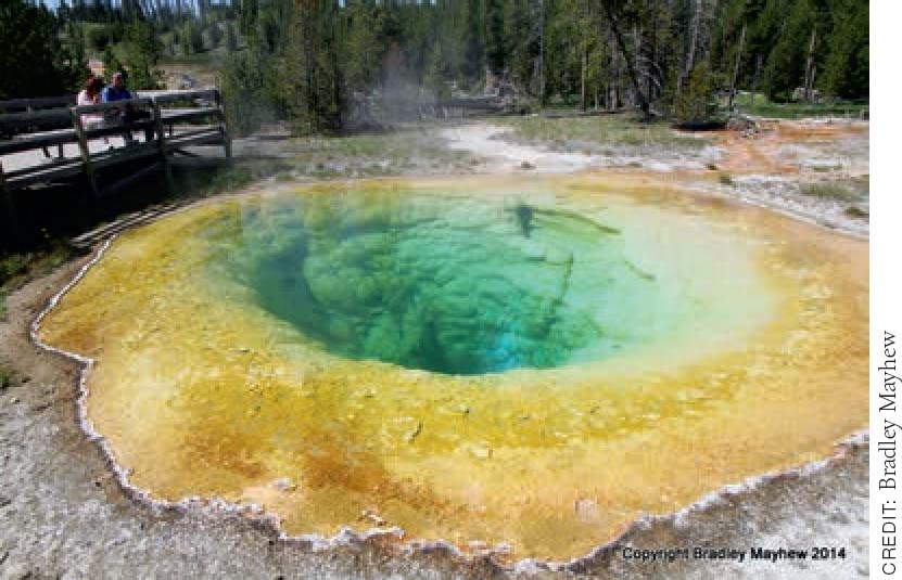
Morning Glory Pool is a crowd favorite and a worthwhile detour from the Upper Geyser Basin Trail.
MILESTONES
▸1 0.0 Start at Old Faithful parking lot
▸2 0.1 Visitor center and restrooms
▸3 0.2 Counterclockwise (right) around Old Faithful boardwalk
▸4 0.3 Right onto Observation Point Trail
▸5 0.35 Firehole River Bridge
▸6 0.4 Right at Geyser Hill Trail boardwalk junction
▸7 0.9 Right onto Observation Point loop trail
▸8 1.0 Observation Point overlook
▸9 1.1 Right at Observation Point Trail junction
▸10 1.4 Left (downhill) from Solitary Geyser
▸11 1.7 Left at Geyser Hill boardwalk junction
▸12 1.9 Straight at end of boardwalk to Firehole River footbridge
▸13 2.0 Left (clockwise) around Old Faithful boardwalk
▸14 2.3 Visitor center
▸15 2.4 Return to parking lot
TRAIL 32 SOUTHWEST YELLOWSTONE
Shoshone Lake and Shoshone Geyser Basin
TRAIL USE
Hike, Backpack
LENGTH
17.0 miles, 2–5 days
VERTICAL FEET
±600
DIFFICULTY
– 1 2 3 4 5 +
TRAIL TYPE
Out-and-back
SURFACE TYPE
Dirt
FEATURES
Backcountry Permit
Lake
Stream
Autumn Colors
Wildflowers
Birds
Wildlife
Great Views
Photo Opportunity
Camping
Geothermal
FACILITIES
Patrol Cabin
Boat Launch
With no road access, forest-lined Shoshone Lake is the largest backcountry lake in the Lower 48. An amazing geyser basin, good fishing, boat-in camping, and the possibility of extended backpacking and kayaking trips add to the allure. Nearly a third of all the park’s backcountry use is concentrated around the lake.
Best Time
Lewis and Shoshone Lakes are usually ice-free by the second or third week in June. Grant’s Pass (8,000 feet), between Lone Star Geyser and the west end of Shoshone Lake, typically isn’t free of snow until late June or early July. Early-season flooding is common at some lakefront campsites, so many sites aren’t available for reservation before July 1 or July 15. Contact a backcountry office for current conditions and for early-season walk-up permits. If you’re planning a late-season trip, say for October, monitor the weather carefully.
Finding the Trail
From the north, head 2.5 miles south on Grand Loop Road from the Old Faithful overpass, and turn right into the Lone Star Geyser parking lot on the south side of the road. From the southeast, go 14.5 miles west from West Thumb Junction over Craig Pass (8,262 feet), and turn left into the parking lot. The trailhead parking area is just south of the Kepler Cascades turnout, which is a parking alternative if the Lone Star lot is full.
The Shoshone Lake Trail is part of the Continental Divide Trail system, which links 3,100 miles of America’s wildest and most dramatic backcountry. Beyond Shoshone Lake, it continues southeast to Heart Lake, the Snake River headwaters, and the Teton Wilderness.
Logistics
Shoshone Lake has more boat-in campsites than hike-in sites. Wood fires are banned along the entire lakeshore; only campsite 8M2, well away from the lake, allows fires. All campsites have primitive toilets and a party limit of eight people, except 8T1, which is limited to one tent and four people.
Boat access is via the boat dock at Lewis Lake Campground and the 3.5-mile Lewis River Channel, which enters Shoshone Lake at its southeast corner. Mandatory boating permits ($5–$20) are available from the South Entrance, Grant Village Backcountry Office, and Bridge Bay Ranger Station. Grand Teton National Park boat permits are honored in Yellowstone. See the Appendix for the locations of and contact details for all Yellowstone backcountry offices.
Trail Description
From the Lone Star trailhead, ▸1 an abandoned service road heads south along the upper Firehole River. After passing the remains of an old water-works, the paved road traces the east bank of the river as it heads upstream.
Geothermal
After passing the Spring Creek Trail junction ▸2 at 1.6 miles, you may hear Lone Star Geyser ▸3 before you see it. For a detailed description of the geyser and environs, see Trail 29. You can get a jump on the hike by cycling this first 2.5 miles.
Wildlife
A few hundred yards beyond the geyser basin, turn left after 2.7 miles at the well-signed Shoshone Lake Trail junction, ▸4 where bison are often spotted wallowing around thermal areas in view of the trail. If you are planning an extended trip, there are three decent first-night trailside campsites in the next 1.5 miles.
First up, the wide-open campsite OA1 ▸5 is the only one that allows stock parties. Four hundred yards down-trail, across the Upper Firehole River, campsite OA2 ▸6 is the best choice. Almost a mile farther upstream, at 4.1 miles, campsite OA3 ▸7 is near Firehole Springs. Beyond here, the trail leaves the river and starts to climb up through unburned forest to the Continental Divide, reaching unsigned Grants Pass (8,010 feet) at the 6-mile mark. ▸8
OPTIONS
Itinerary Options
The return hike to Shoshone Geyser Basin is just about doable as a very long day hike, especially if you shave 5 miles off the hike by cycling the section from the trailhead to Lone Star Geyser and back. Much better is to make this an overnight trip, camping en route at site 8G1, 8R5, or 8T1. Better still, turn this into a three-day shuttle hike by continuing along the North Shoshone Lake Trail, spending the second night on the lake-shore at site 8R3, 8R2, 8S3, or 8S2 before hiking out to DeLacy Creek Trailhead for a 21-mile walk.
For the full loop of Shoshone Lake and return to Lone Star Geyser, you are looking at a four- or five-day trip from the Lone Star trailhead.
There are a total of three trail-accessible, five boat-in, and two mixed hiking–boating campsites along Shoshone Lake’s north shore. The south shore has eight boat-in sites, one tent-only site, and one two-party, hiking–boating site at the head of the Lewis River Channel. The remaining two trail-accessible sites (8M1 and 8M2) are well removed from the south shore and are shared with stock parties. Wood fires are prohibited at all Shoshone Lake sites.
Alternate Trailheads
For the quickest route to Shoshone Lake, the DeLacy Creek trailhead, about halfway between Old Faithful and West Thumb Junction, is the place. The hike to the north lakeshore is 4–5 hours and 6 miles round-trip, with 200 feet of elevation loss on the way down.
Soon after the anticlimactic pass, you drop down along an upper fork of Shoshone Creek to the signed Bechler River Trail junction. ▸9 The hiker-and llama-only campsite 8G1 ▸10 (no wood fires) is a hundred yards off-trail to the right, in Shoshone Meadows, 6.5 miles from the trailhead.
Wildlife
Watch for moose as you descend along and cross over Shoshone Creek on a footbridge. A mile downhill from the junction, keep to the main trail; don’t take the signed horse bypass trail that forks off across a footbridge to the right (it loops 2.2 miles around to the south side of Shoshone Geyser Basin). ▸11
Continue down the pretty drainage for another mile to the North Shoshone Lake Trail junction, ▸12 8.3 miles from the trailhead. The left fork contours above the lake’s north shore past the splendid hiker-only campsite 8R5 fronting Basin Point Bay, offering an excellent overnight option. This section of trail is officially called the North Shoshone Lake Trail but is known more casually as the North Shore Trail.
Geothermal
Following instead the right fork of the main Shoshone Lake Trail, you pass through a marshy area and soon arrive at the extraordinary and very volatile Shoshone Geyser Basin. ▸13 Unlike heavily visited frontcountry geyser basins, there’s a notable absence of boardwalks, railings, and signage here. Please tread lightly through the fragile thermal areas; help keep the basin pristine by using common sense and keeping your wits about you as you explore the captivating thermal features rarely found so near the trail.
Besides the aforementioned campsite 8R5, trailside, hiker-only campsite 8T1 (one tent and four-person limit) is the closest to the basin, a few hundred yards south of the junction of the horse bypass trail and the trail along the south shore. If you can’t secure a reservation at one of these two popular sites, it’s another 3 miles in either direction to the next options.
Shoshone Geyser Basin is Yellowstone’s most active backcountry hydrothermal area, with around 70 geysers in active phases at any given time.
CAUTION
Boating Safety on Shoshone Lake
Frequent high winds and extremely cold water (which is often 40°–50°F and rarely warms above 60°F) pose serious challenges for canoeists and kayakers on the 8,000-acre lake. Suitable bailing and personal flotation devices are required at all times. For maximum safety, avoid open-water crossings, and travel close to the shore and in the early morning and late afternoon, when winds are calmer.
It’s not possible to paddle upstream for the northernmost mile of the Lewis River channel. Instead, you must wade through up to 3–4 feet of cold water and drag your boat through the rocky-bottomed stream. Motors are allowed for crossing Lewis Lake but must be left at the south end of the channel. Finally, the National Park Service suggests that boat-in campers select a site on the southern lakeshore for the first night of any trip.
Lake 
Our trail description ends here, but, depending on how many days you have to experience this fascinating area, your explorations should be just beginning. Once you’ve finished relaxing, fishing, watching the myriad wildlife and waterfowl, and enjoying the lake, retrace your steps northwest on the Shoshone Lake Trail, back to the Lone Star trailhead. ▸14
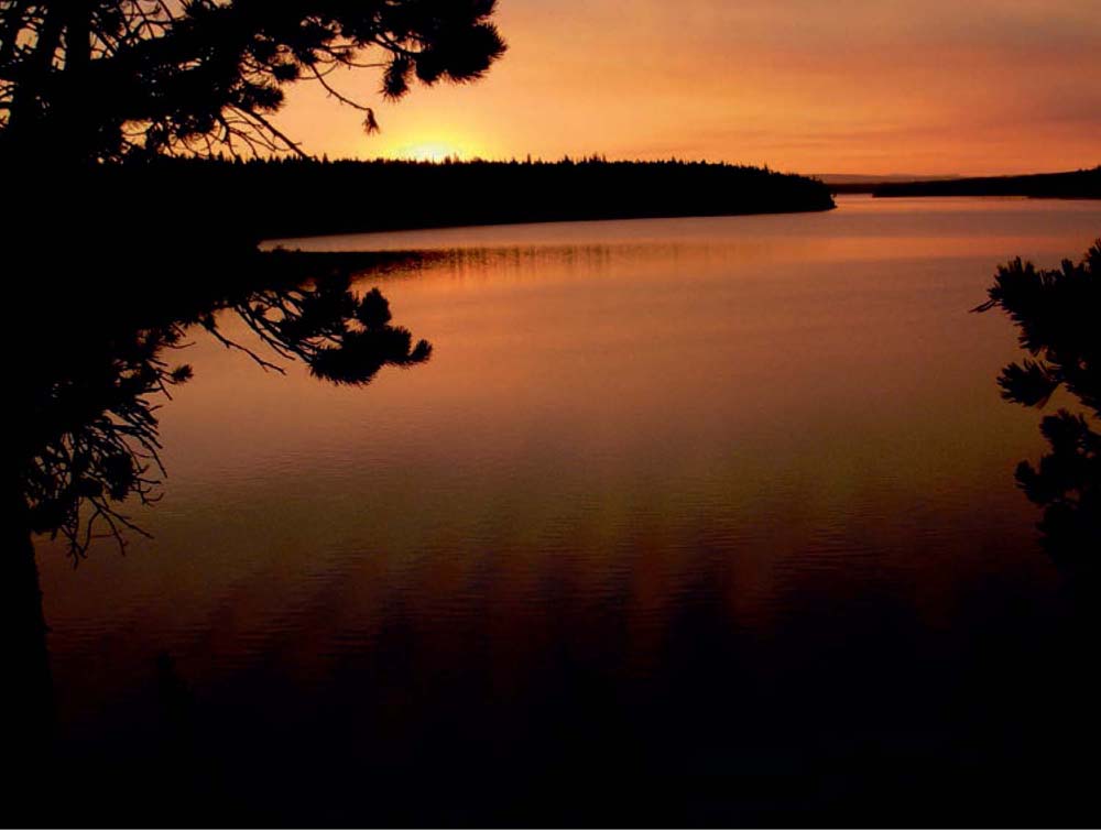
An overnight backpacking trip rewards with sunset views over Shoshone Lake.
CREDIT: Bradley Mayhew
MILESTONES
▸1 0.0 Start at Kepler Cascades turnout/Lone Star trailhead parking lots
▸2 1.6 Right at Spring Creek Trail junction
▸3 2.5 Lone Star Geyser
▸4 2.7 Left at Shoshone Lake Trail junction
▸5 2.9 Campsite OA1
▸6 3.3 Campsite OA2
▸7 4.1 Campsite OA3
▸8 6.0 Grants Pass
▸9 6.4 Left at Bechler River/Shoshone Lake Trail junction
▸10 6.5 Campsite 8G1
▸11 7.4 Stay on main trail at Horse Bypass Trail junction
▸12 8.3 Right at North Shoshone Lake (North Shore) Trail
▸13 8.5 Shoshone Geyser Basin
▸14 17.0 Return to Lone Star trailhead parking lots
TRAIL 33 SOUTHWEST YELLOWSTONE
Terraced Falls
TRAIL USE
Hike
LENGTH
3.6 miles, 1–2 hours
VERTICAL FEET
±250
DIFFICULTY
– 1 2 3 4 5 +
TRAIL TYPE
Out-and-back
SURFACE TYPE
Dirt
FEATURES
Child Friendly
Canyon
Stream
Waterfall
Autumn Colors
Cool & Shady
Great Views
Photo Opportunity
Secluded
Geologic Interest
FACILITIES
None
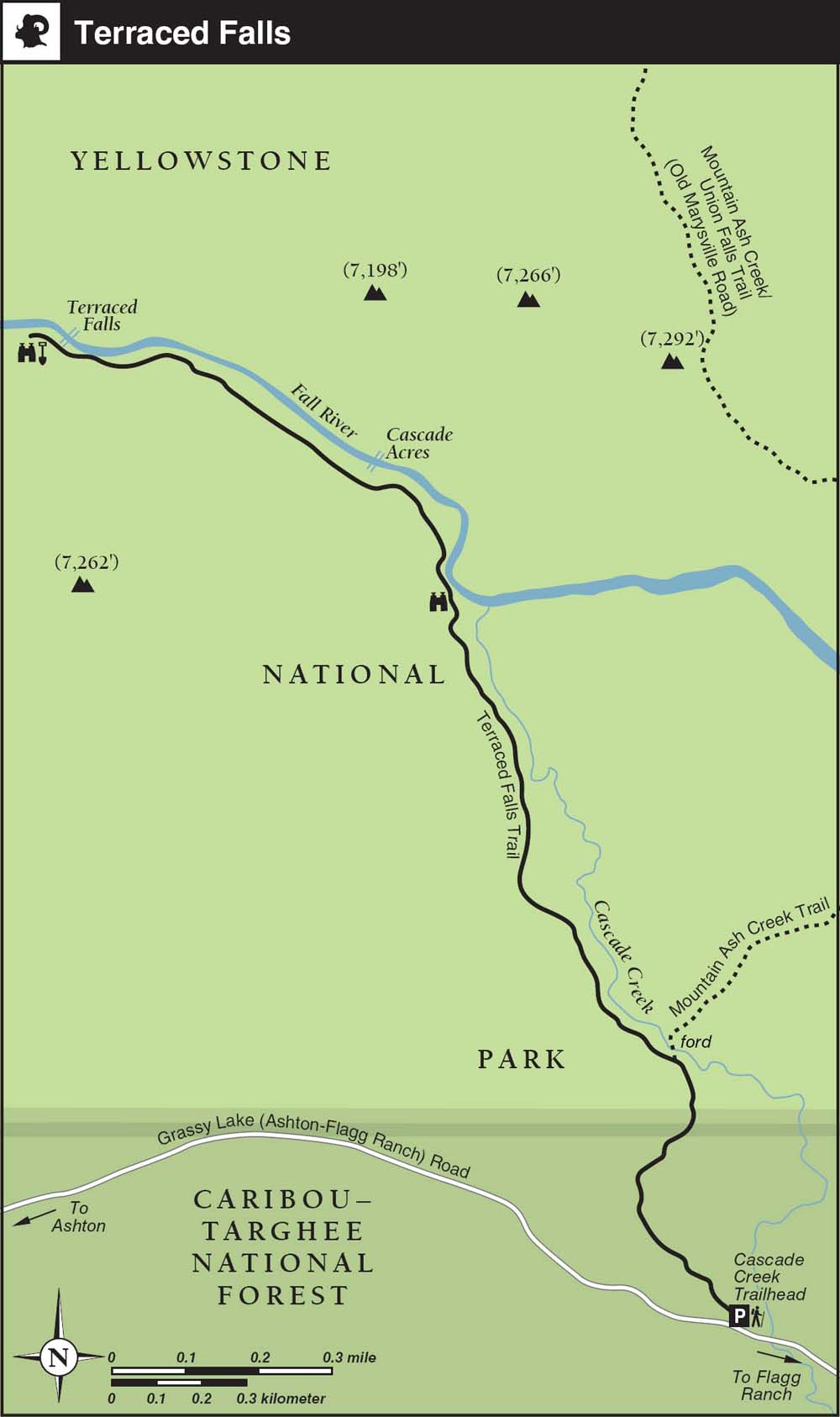
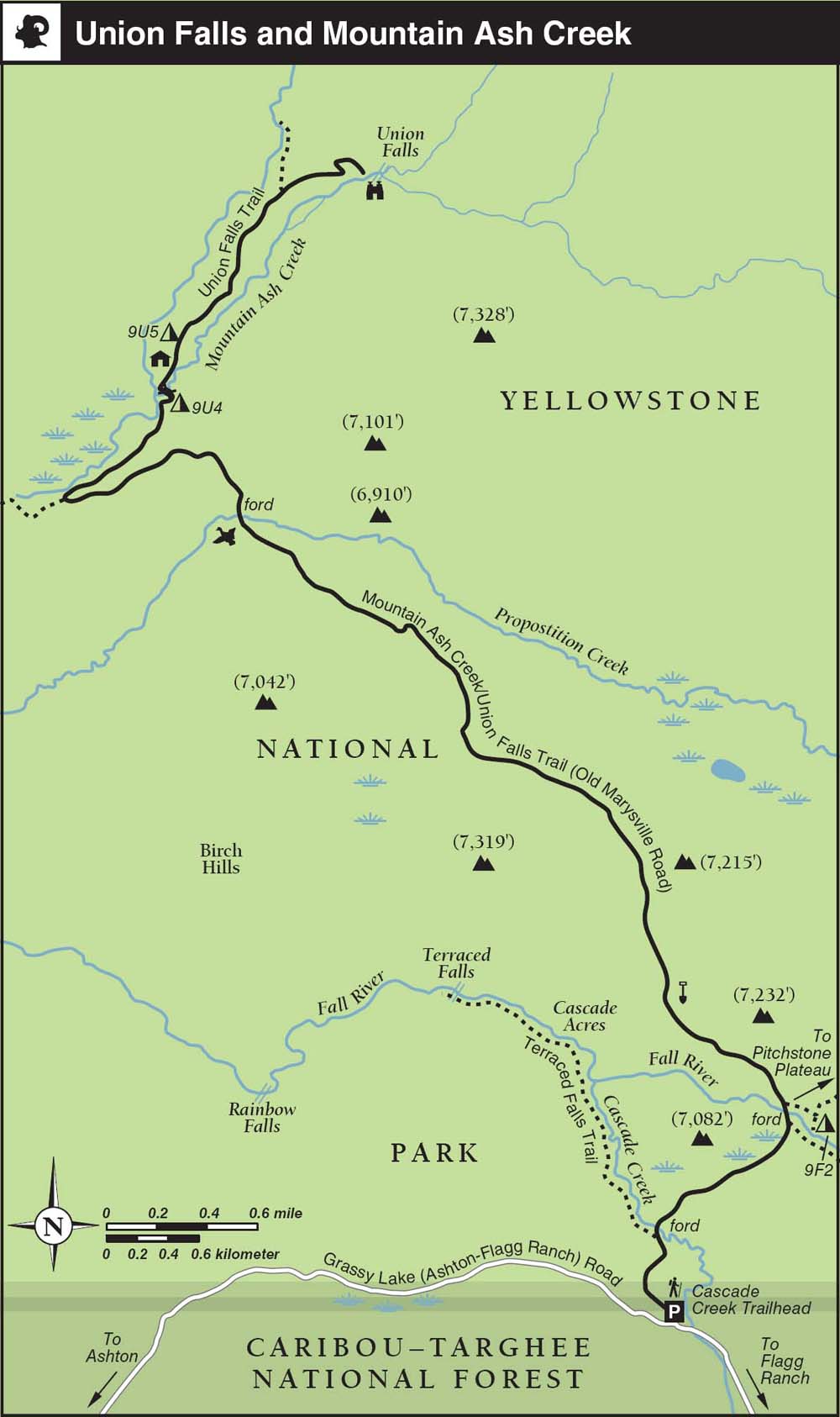
This remote riverside trail is difficult to access, but once you’re there, it’s a level, short hike and offers an up-close look at one of the Cascade Corner’s bigger multitier waterfalls, set in a dramatic, volcano-forged canyon. If you’re already in the area, it’s a great late-season option and combines nicely with an overnight trip to Union Falls.
Best Time
There are no fords, so theoretically the trail can be hiked from about mid-June through October. In reality, the Grassy Lake access road is often rough going during late spring and early summer, and like the rest of the Bechler region, it can be quite buggy until August. Grassy Lake Road closes for the winter as soon as snow levels make keeping the road open impractical. It’s most enjoyable when fall colors peak, around the autumnal equinox.
Finding the Trail
From Yellowstone’s South Entrance, go 2.5 miles south and turn right at Flagg Ranch. Follow the signs for Grassy Lake Road (called Ashton–Flagg Ranch Road, Reclamation Road, or USFS Road 261 on older maps). Drive west through the John D. Rockefeller Jr. Memorial Parkway area (administered by Grand Teton National Park) along a bumpy gravel road, past eight free, primitive campgrounds (with toilets and picnic benches but no water). After 9 miles, without much fanfare, the road enters the Caribou-Targhee National Forest. This section of road near the reservoir has a terrible reputation, but it’s not that bad, especially in later summer. This is one hike where the drive there is more taxing than the hiking trail.
Terraced Falls, with its graceful lines, is one of Bechler’s most accessible waterfalls.
CREDIT: Bradley Mayhew
Fortunately, the Cascade Creek trailhead is only 1.5 miles beyond the dam, on the northwest end of Grassy Lake Reservoir, on the right (north) side. If the small trailhead parking area is full (not likely), there’s a large parking area directly across the road, with free dispersed camping among the lodgepole pines.
From the west in Ashton, Idaho, it’s an even rougher 36-mile scramble over gravel Forest Service roads. Part of the route follows an old wagon trail, and often it feels that way, though to be fair the road has improved greatly in recent years.
The Terraced Falls overlook sits atop the geographic limit of Yellowstone’s Cascade Corner. It straddles the edge of lava flows that ended here approximately 70,000 years ago.
Trail Description
From the National Park Service–signed Cascade Creek (9K5) trailhead ▸1 in the Caribou-Targhee National Forest, the little-used but well-maintained trail descends gently through lodgepole pine forest 0.3 mile to the southern Yellowstone National Park boundary. ▸2 The boundary is indicated both by posted signs and a notice board that posts National Park Service regulations. Soon the route meets a cutoff trail to the Pitchstone Plateau, ▸3 next to an easy ford of Cascade Creek.
Viewpoint
Take the left branch just before the ford for the Terraced Falls Trail. The path winds through mixed lodgepole pine stands as it traces the west bank of Cascade Creek. After 0.6 mile the creek joins the Fall River at a lovely confluence. ▸4 En route, stop to admire the long set of rapids known as Cascade Acres.
Alternative Trailhead and Overnight Options
This trip is easily combined with an overnight stay near Union Falls (see Trail 34) or added to the beginning or end of a long romp over the wild Pitchstone Plateau. The Grassy Lake trailhead, 1.5 miles east, is an alternative starting point, but this adds 300 feet of elevation gain and 3.2 miles to the trip.
For an easy overnighter, consider backcountry campsite 9F2. From the junction with the Terraced Falls Trail, the Pitchstone Plateau cutoff trail leads 0.8 mile to the campsite, near the junction for the Mountain Ash Creek Trail to Union Falls.
Waterfall
Although the Fall River isn’t always in view for the final 0.7 mile to the picture-perfect Terraced Falls overlook, ▸5 it’s almost always within earshot.
The maintained trail dead-ends at the overlook of the falls. The river continues flowing downstream through a rugged canyon to plunge over inaccessible Rainbow Falls and eventually meet the Bechler River just upstream from Cave Falls, near the Bechler Ranger Station.
After you’ve finished picnicking and exploring around the falls, retrace your steps to return to the trailhead parking area. ▸6
MILESTONES
▸1 0.0 Start at Cascade Creek trailhead
▸2 0.3 Straight at Yellowstone National Park boundary
▸3 0.5 Left on Terraced Falls Trail just before Cascade Creek ford
▸4 1.1 Cascade Creek/Fall River confluence
▸5 1.8 Terraced Falls overlook
▸6 3.6 Return to trailhead parking area
TRAIL 34 SOUTHWEST YELLOWSTONE
Union Falls and Mountain Ash Creek
TRAIL USE
Hike, Backpack, Horse
LENGTH
15.8 miles, 8–10 hours
VERTICAL FEET
±1,800
DIFFICULTY
– 1 2 3 4 5 +
TRAIL TYPE
Out-and-back
SURFACE TYPE
Dirt
FEATURES
Backcountry Permit
Canyon
Stream
Waterfall
Autumn Colors
Photo Opportunity
Camping
Swimming
Secluded
Geologic Interest
FACILITIES
Horse Staging
The most impressive backcountry waterfall in Greater Yellowstone and a sublime swimming hole await at the end of this hearty daylong hike. A couple of campsites near Union Falls allow for an easy overnight trip.
Best Time
Like most of the Cascade Corner, it’s buggy and wet here until early August. Things dry out by late summer, but the falls are most impressive during the first half of July. The 9U group of campsites, all within 5 miles of the falls, don’t dry out until early July. The heaviest trail usage happens before Labor Day, when scouting troops and day-trippers on horseback are out in force. Depending on the weather, October can be a wonderful time to hike here.
Finding the Trail
Getting to the trailhead is half the fun: From Yellowstone’s South Entrance, go 2.5 miles south and turn right at Flagg Ranch. Follow the signs for Grassy Lake Road (called Ashton–Flagg Ranch Road, Reclamation Road, or USFS Road 261 on older maps).
Continue 9 miles west through the John D. Rockefeller Jr. Memorial Parkway area (administered by Grand Teton National Park) along the decent, graded gravel road past eight free primitive campgrounds. At 9 miles, without much fanfare, the road enters the Caribou-Targhee National Forest and begins to rapidly deteriorate. Depending on the season, the stretch around the reservoir can be easy going or a spine-jarring washboard riddled with huge, tire-eating potholes.
Fortunately, the Cascade Creek trailhead is only 1.5 miles beyond the dam, on the northwest end of Grassy Lake Reservoir, on the right (north) side. If the small trailhead parking area is full (not likely), there’s a large parking area directly across the road, with free dispersed camping among the lodgepole pines.
From the west in Ashton, Idaho, it’s an even rougher 36-mile scramble over gravel Forest Service roads. The road follows an old wagon route, and often it feels that way.
Trail Description
Beyond the Cascade Creek trailhead ▸1, the first 0.3 mile of trail descends gradually through the Caribou-Targhee National Forest to a sign for the south boundary of Yellowstone National Park ▸2.
A few hundred yards beyond a notice board—which posts National Park Service regulations, our trail meets the Terraced Falls Trail, ▸3 (see Trail 33). If you are overnighting at Union Falls, it’s worth adding on the 2.6-mile detour to see Terraced Falls, either now or on the way back. The Cascade Creek ford here is short and shallow, if ice-cold, but you can generally find a dry route across the logjam. Beyond the ford, the trail crests a short, forested ridge and then drops back down through willow-choked marshland to a junction with the Mountain Ash Creek Trail, above the Fall River ford. ▸4 This ford, at 1.2 miles, is 50 feet wide, and the thigh-high current can be quite swift through July. Later in the season, it’s an easy, if slippery, less-than-knee-high crossing; bring wading shoes and a stick or trekking pole. By mid-September, it’s barely calf-high.
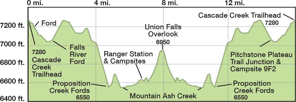

Union Falls is one of Yellowstone’s tallest plunges and one of the most beautiful falls in the backcountry.
Camping
The Pitchstone Plateau Trail junction, ▸5 also the turnoff for campsite 9F2, is immediately beyond the ford. Forking left toward Union Falls, it’s a steady climb several hundred feet away from the river onto a forested plateau. As the sounds of the river fade, the trail levels off in a mature stand of mixed conifers.
Geologic Interest 
As a valley opens up to the left, watch for shiny, black volcanic rock to start showing up underfoot. It’s a rocky descent down an open slope, along an 1880s wagon road route, to Proposition Creek, ▸6 at 4.9 miles from the trailhead. Blue jays flit about the fir–spruce forest around the two easy fords here. Don’t be surprised by the chipmunks trawling the dense underbrush for mushrooms alongside the trail in the fall. After 0.8 mile, you arrive at another junction overlooking Mountain Ash Creek, ▸7 where the trail doubles back and makes a hard right upstream along the creek.
OPTIONS
Alternate Trailheads
From the Bechler Ranger Station trailhead, it’s 12.5 scenic, nearly flat miles one-way to Union Falls.
From the Fish Lake trailhead—0.5 mile down a very rough, high-clearance four-wheel-drive track off Grassy Lake Road—it’s 7.8 level miles one-way to the falls, including a couple of significant river fords. The unmaintained track down to Fish Lake trailhead is mostly used by stock parties. The Fish Lake Trail itself passes by several pretty lakes and through a small but beautiful slice of the U.S. Forest Service–administered Winegar Hole Wilderness before entering Yellowstone National Park.
A couple of miles east of the Cascade Creek trailhead near Grassy Lake Reservoir, the Grassy Lake trailhead is a slightly longer and less scenic approach to the Union Falls Trail, which it joins at the Pitchstone Plateau Trail junction.
Camping
After 0.5 mile along the south bank, look for a footbridge across the creek just before the signpost for the pleasant, hiker-only campsite 9U4 ▸8 (wood fires allowed, two-night limit). The seasonal Union Falls Patrol Cabin ▸9 is a few hundred yards beyond the bridge on the left side, 6.4 miles from the trailhead. A spur trail heads several hundred yards off to the left to the equally pleasant campsite 9U5 ▸10 (no wood fires, two-night limit), which is popular with stock parties. This site enjoys easy access to a shallow northern fork of Mountain Ash Creek that’s warm enough for dipping in, and there’s a large meadow out the front door; it’s well worth the extra trek a few hundred yards off the trail.
Beyond the Ranger Station, it’s a bit slow going on the sandy, horse-worn trail for the next mile. Fortunately, only foot travel is allowed beyond the final unsigned fork ▸11, where there’s a horse-hitching area.
Swimming
The left fork, which deceptively appeared to be the main fork during my last visit, dead-ends after 0.3 mile at an unnamed waterfall and sublime, lukewarm swimming hole known as Ouzel Pool (also called Scout Pool for the heavy use it receives by Boy Scout troops in midsummer). Carefully dog-paddle your way into a natural seat at the base of the falls to experience an indescribable natural whirlpool pummeling.
Waterfall
The unsigned right fork—which may still appear to be a mere runoff gully—winds around uphill 0.5 mile to the Union Falls ▸12 overlook, 7.9 miles from the trailhead.
Photo Opportunity
No doubt about it, the multifaceted, 250-foot plunge is a real gusher. Just follow your ears toward the oceanlike sound: you’ll hear it well before the falls come into view. Depending on the season, the precipitous, unmaintained path down to the base of the falls can be slick and treacherous, thanks to heavy mist from the falls.
If you can pull yourself away (it’s getting late, no?), retrace your steps back to the Cascade Creek trailhead parking area. ▸13
MILESTONES
▸1 0.0 Cascade Creek trailhead
▸2 0.3 Yellowstone National Park boundary
▸3 0.4 Ford Cascade Creek at Terraced Falls Trail junction
▸4 1.2 Fall River ford
▸5 1.3 Left at Pitchstone Plateau junction; campsite 9F2 turnoff
▸6 4.9 Proposition Creek fords
▸7 5.7 Right at Mountain Ash Creek Trail junction
▸8 6.2 Campsite 9U4
▸9 6.4 Union Falls Patrol Cabin
▸10 6.6 Campsite 9U5 spur trail
▸11 7.4 Right at unsigned horse-hitch junction
▸12 7.9 Union Falls
▸13 15.8 Return to Cascade Creek trailhead