FEW VEGETATION TYPES make as much impact on the landscape as the ombrogenous bogs. Their expanses of wet treeless peat country, covered with cottongrasses, Sphagnum and heather, and summer home to curlew, dunlin and golden plover, are an essential part of the character of the windswept and rainy north and west of Britain and Ireland. The ombrogenous peatlands that formerly dominated wide low-lying tracts of flat country bordering many of our larger rivers and estuaries, in the Somerset Levels, and most extensively of all in the midland plain of Ireland, must have been just as dramatic – as indeed fragments that are left of them still are. These bogs have acquired fresh topicality with current concern over atmospheric CO2 levels and global warming. The northern peatlands of Eurasia and North America represent one of the major stores of carbon on the planet, estimated at around 300 billion tonnes, and their fate affects us all.
THE DISTRIBUTION AND LIMITS OF OMBROGENOUS BOGS IN BRITAIN AND IRELAND
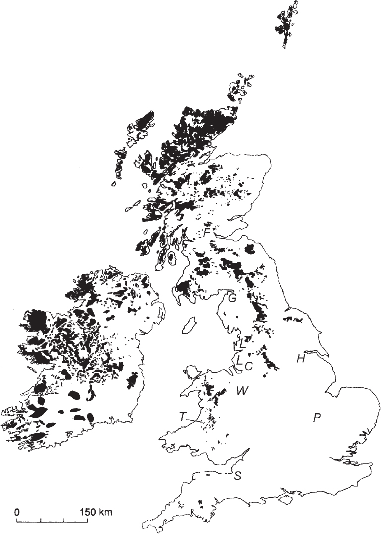
According to the Soil Survey, ombrogenous peats cover some 2.5% of the land surface area of England and Wales. Nearly 17% of Ireland is covered by peat; the figure for Scotland is around 10% (Fig. 198). These are figures for peat; the proportion carrying active ombrogenous-bog vegetation at the present day is much less. British and Irish plant ecologists have generally distinguished ‘raised bogs’, mainly lowland and often the product of hydrosere succession from former lakes or the floodplains of rivers, from ‘blanket bogs’, which as their name implies blanket the landscape in high-rainfall areas. However, this is not a sharp distinction.
FIG 198. The distribution of ombrogenous peats in Britain and Ireland, based mainly on Taylor (satellite data), the Soil Survey of England and Wales, and Doyle & O Críodáin (2003). Letters show the approximate locations of some former and extant lowland raised bogs in Britain: C, Chat Moss; F, Flanders Moss; G, Glasson Moss and Wedholme Flow; H, Humber-head peatlands (Thorne and Hatfield Moors); L, Lancashire mosses; P, former bogs south of Peterborough; S, Somerset Levels; T, Cors Tregaron; W, Fenns and Whixall Mosses.
FIG 199. Malham Tarn Moss, Yorkshire, from Chapel Fell, August 1990.
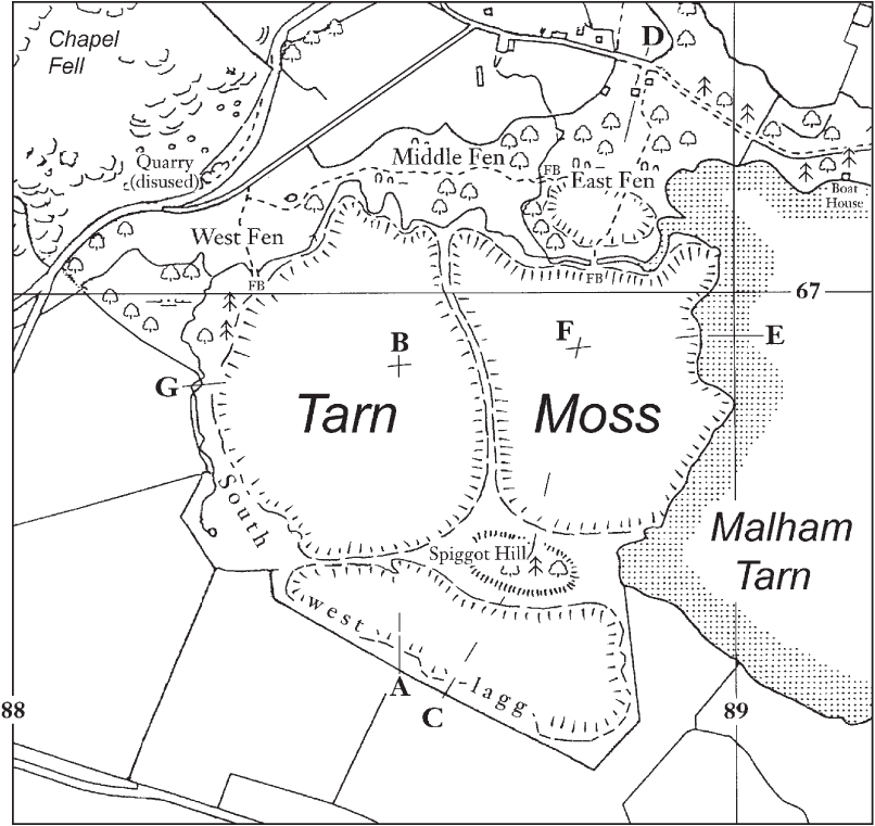
Malham Tarn Moss (Figs 199, 200) shows some typical features of a raised bog and its surroundings. The gently domed area of ombrogenous peat drains radially into a belt of minerotrophic fen, the lagg, separating the bog from the surrounding mineral ground. Often the drainage in the lagg is channelled into a stream, as it is here in the lower part of the southwest lagg. The inflow streams from the fields to the west, and springs from the base of the limestone to the north, skirt the bog on its northern side, meandering through a belt of calcareous fen; some small isolated raised bogs have grown up in the meanders, mostly now covered with birch. The margin of the acid peat, sloping down to the lagg, is called the rand.
Because of their relative accessibility, lowland raised bogs have borne the brunt of drainage and reclamation for farming. The Somerset Levels between Street and Wedmore bore substantial raised bogs, of which little trace now remains. The raised bogs that existed between Huntingdon and Peterborough have all but vanished, but despite intensive exploitation in the past half-century, more remains of the vast expanses (c. 3000 ha) of raised bog near the head of the Humber estuary, and of the Fenn’s and Whixall mosses near Whitchurch on the Welsh–English border. Following drainage, ploughing and fertilising, Chat Moss west of Manchester, which gave such trouble to George Stephenson when he built the Liverpool & Manchester Railway in the late 1820s, has long been a prolific market-gardening area. There are still some raised bogs around the estuaries south of the Lake District, and Glasson Moss and Wedholme Flow south of the Solway are among the best remaining examples in Britain. Flanders Moss in the Forth valley, 15 km west-northwest of Stirling, is another large expanse of lowland raised bog. All these big areas of raised bog have been encroached on at their edges by agriculture or other development, which obscure their geographical context. Cors Caron (Tregaron Bog) in mid Wales is still essentially intact despite some peat cutting round the edges (Fig. 218). There are many smaller raised bogs scattered round Britain, some with their plant cover or landscape context more or less intact. Rainfall in Britain has evidently almost everywhere sufficed to support raised-bog growth in suitable sites.
FIG 200. Malham Tarn Moss, illustrating some features of a raised bog. The dome of acid peat (three coalesced domes here) drains radially into the lagg separating the bog from the adjacent mineral ground, or the Tarn to the east. The sloping margin of the acid peat abutting on the lagg is the rand. Letters A–G correspond to the sections in Fig. 174 (Chapter 13).
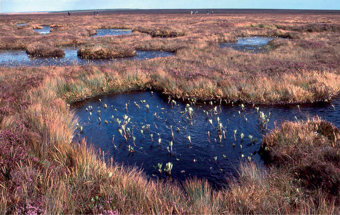
At the close of the last glaciation, the midland plain of Ireland was left as an undulating, lake-studded expanse of (predominantly) clayey glacial drift, a near-perfect template for hydrosere development. By historical times, large tracts of lowland Ireland were occupied by raised bogs, broken by hills wooded with ash, elm and hazel (the mineral soils of the midland plain are predominantly calcareous), and by the winding gravelly ridges of eskers (former sub-glacial drainage channels). The bigger Irish raised bogs were on a scale that few sites in Britain could match, but they have now mostly been cut away to fuel peat-fired power stations, or for other uses including the horticultural industry and for peat briquettes as household fuel. Of those that remain unexploited, Clara Bog (Fig. 201) northwest of Tullamore and Mongan Bog near Clonmacnoise, both in Co. Offaly, are still impressive expanses of peatland. The rainfall over these Irish bogs is always over 800 mm and often over 1000 mm a year.
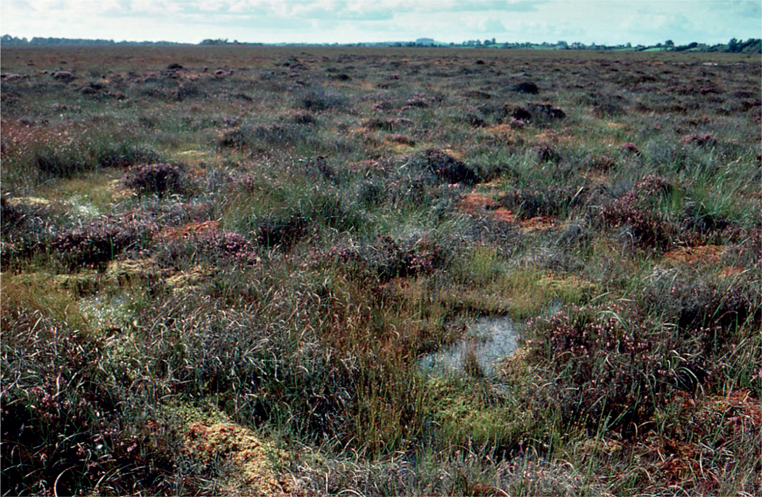
FIG 201. Clara Bog, Co. Offaly, September 1988. A view of the undisturbed western part of the bog; a thoroughly typical piece of active raised bog surface.
FIG 202. Roundstone Bog, Co. Galway, September 1997; the Twelve Bens in the background. The grey tinge of black bog-rush (Schoenus nigricans) is typical of western Irish lowland blanket bogs.
Blanket bogs occupy two at first sight rather distinct but intergrading habitats. First, they are characteristic of the high-rainfall areas of the far west of our islands, in Kerry, Galway, Mayo, Donegal, and western Scotland from Galloway, Argyll and the Hebrides to Sutherland, Caithness and Shetland (Fig. 202). In fact, lowland blanket bog is better correlated with areas experiencing more than 250 ‘rain days’ a year than with rainfall as such (Fig. 203). Second, blanket peats cover many flattish or undulating plateaux, as on Dartmoor, much high ground in mid and north Wales, the Pennines in northern England (Fig. 204), the Southern Uplands of Scotland and similar ground in the Highlands and Ireland. These are mostly 400–600 m above sea level, with over 1500 mm annual rainfall and over 225 ‘rain days’ a year, but the limits vary from one region to another. However, the distinction between lowland and upland blanket bogs is probably more apparent than real, and mainly reflects where vegetation ecologists have concentrated their studies, and their preconceptions. Probably the same applies to the traditional distinction between ‘raised bog’ and ‘blanket bog’, of which more later. First, there is much that all ombrogenous bogs have in common.
FIG 203. Mean annual number of days with at least 0.2 mm rainfall (‘rain days’) in Britain and Ireland, 1901–1930. The lowland blanket bogs in western Ireland occur within the area experiencing at least 250 rain days; in west and north Scotland the limiting figure is nearer 225 rain days.
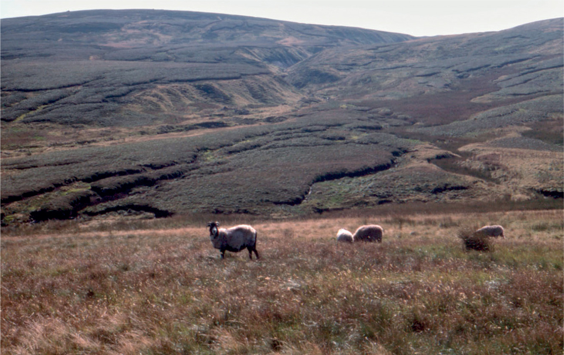
FIG 204. Calluna–Eriophorum vaginatum blanket bog in the Pennines, on the road from Swaledale to Kirkby Stephen, August 1993. Swaledale sheep are a hardy hill breed that can make a living on the meagre pasture of the bog and the mat-grass (Nardus) and rushy grasslands surrounding it.
OMBROGENOUS BOG VEGETATION: THE COMMON SPECIES
The species list on an ombrogenous bog is typically rather short, made up predominantly of a few ericaceous subshrubs, a few sedges, ‘bog-mosses’ of the genus Sphagnum, and a handful of other species. The common heather Calluna vulgaris is nearly ubiquitous in the bogs of north and west Europe, sometimes dominant, sometimes present only as a scatter of impoverished shoots. Towards the Atlantic seaboard of Europe, including the whole of Britain and Ireland, Calluna is joined by the cross-leaved heath (Erica tetralix). Three sedges are common in British and Irish bogs. The rhizomes of the common cottongrass (Eriophorum angustifolium) are virtually all-pervading in any kind of bog, ombrogenous or not, throughout most of Britain and all of Ireland. The scattered long leaves differ from most sedges in their gutter-shaped (rather than V-shaped) cross-section, and their red hue late in the season. E. angustifolium flowers early in spring, but the flower-spikes (several to a stem) are most conspicuous later when the white cottony bristles elongate in fruit. Hare’s-tail cottongrass (E. vaginatum) contrasts with its congener in every way. It grows in dense tussocks, with narrow leaves no wider than the flower stems, each of which bears only a single inflorescence at its tip (Fig. 205). Hare’s-tail cottongrass dominates wide tracts of bog in the Pennines and elsewhere, and the cottony tufts dancing in the breeze are a fine sight in early summer. In many wetter bogs E. vaginatum is more scattered and does not form large tussocks, but it is seldom completely absent. Another tussocky sedge is deergrass (Trichophorum cespitosum), which again is seldom completely absent, but comes into its own when its tussocks dominate wide monotonous expanses of degraded peat in the western Highlands of Scotland and elsewhere (it seems to be favoured by trampling and compression of the peat). Its stems bear an insignificant flower-spike at their tips, and colour a yellowish tinge late in the year; the leaves are a mere few millimetres long on the sheaths at the base of the stem.
FIG 205. Hare’s-tail cottongrass (Eriophorum vaginatum) is near-ubiquitous in ombrogenous bogs, and often dominant, as it is in the Pennines. Cottongrasses flower very early in the year, and only develop the cottony bristles in fruit. Here sunlight has picked out the inflated leaf-sheaths on the fruiting stems that give the species its name. Exmoor, June 1995.
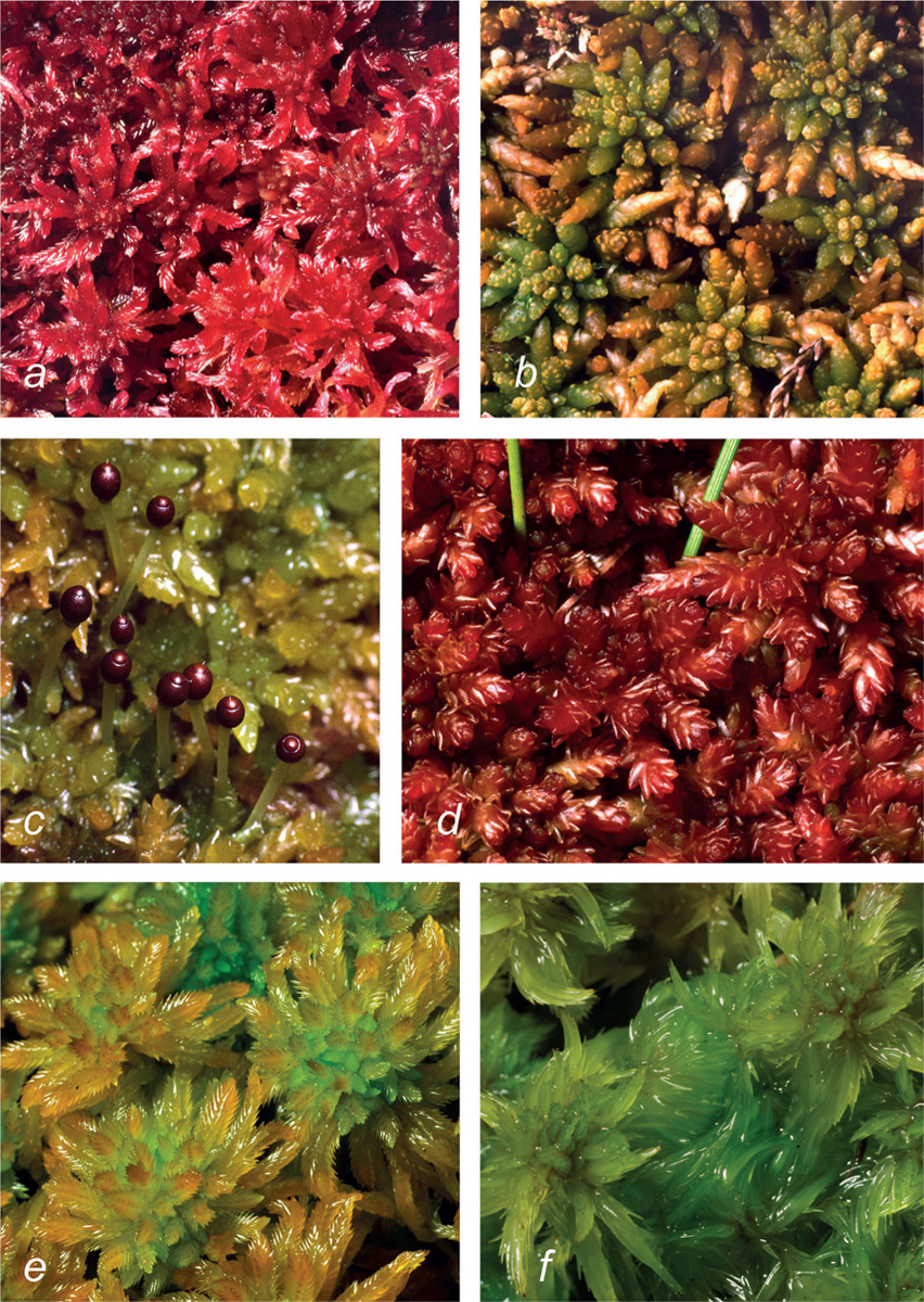
FIG 206. Some characteristic ombrogenous bog Sphagnum species: (a) S. rubellum; (b) S. austinii; (c) S. papillosum; (d) S. magellanicum; (e) S. pulchrum; (f) S. cuspidatum.
Sphagnum numbers about 30 species in Britain and Ireland, of which only some half-a-dozen are common in ombrogenous bogs (Fig. 206). The commonest is S. papillosum, a coarse green to brownish species forming lawns or low hummocks. In some places it is accompanied or replaced by S. magellanicum, of similar growth-form but deep wine-red in colour. Sphagnum rubellum is also pink to reddish, and typically builds taller hummocks than the last two species. Sphagnum pulchrum forms wide lawns in hollows; it is more local (and more oceanic) in distribution but often abundant where it occurs. Sphagnum cuspidatum, a common yellowish-green species with long narrow leaves, occupies wet hollows and often grows floating in bog pools. It has been likened to a ‘drowned kitten’ when taken out of the water. Two other hummock-forming species are of similar build to S. rubellum. Sphagnum capillifolium tends to replace S. rubellum on upland bogs in the north of England and in Scotland, and produces capsules much more freely. Sphagnum fuscum occurs mostly in Scotland and Ireland, looks like a brown S. rubellum or capillifolium, and typically forms tight cushions. Another hummock-former, S. imbricatum subsp. austinii (or S. austinii), was the principal peat-forming Sphagnum in Britain and Ireland from the ‘Atlantic’ period (Chapter 2) until medieval times. It is a big species, matching S. papillosum in size, and its easily recognised remains are abundant in the peat (Fig. 207). It remains frequent only in the north and west, and nowhere does it retain its former dominance.
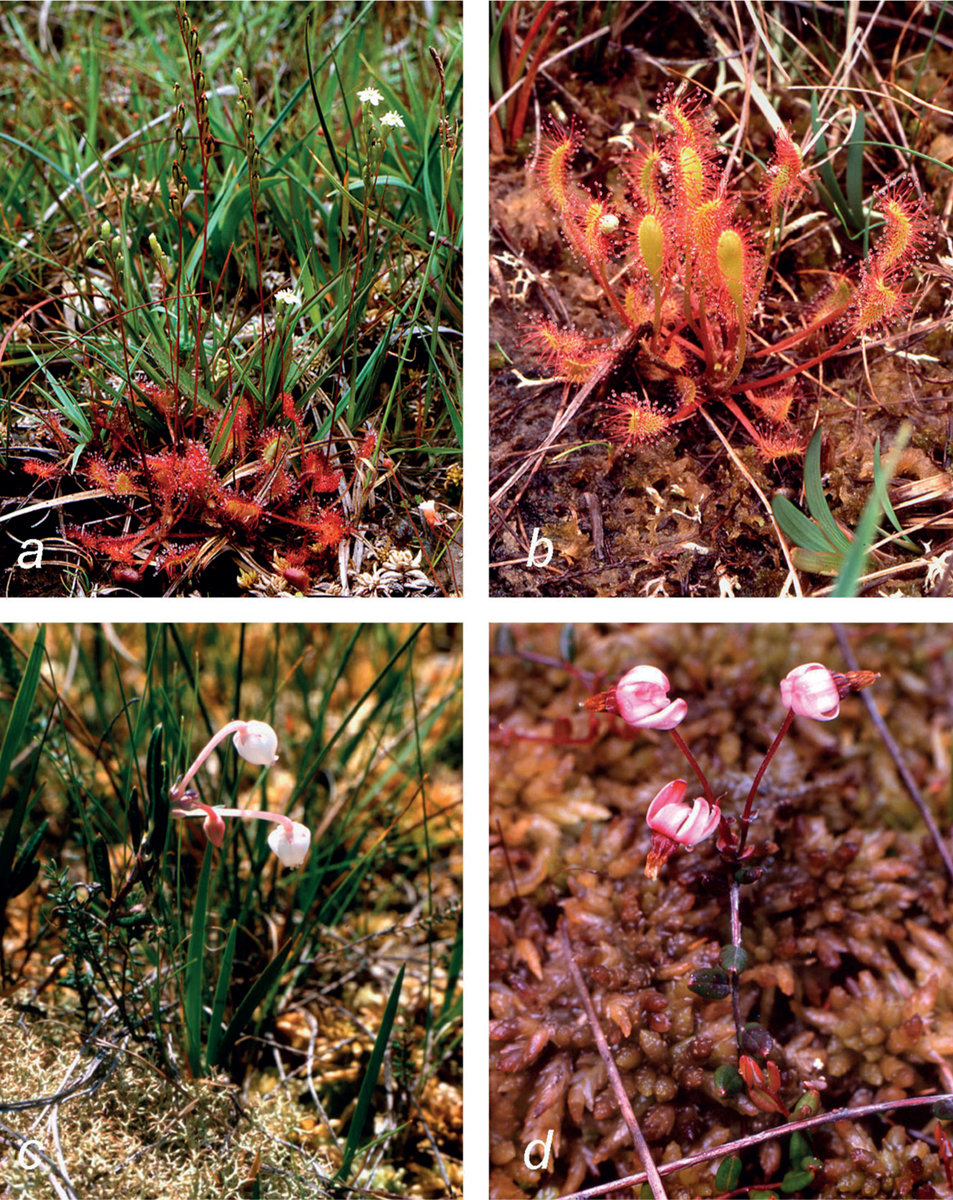
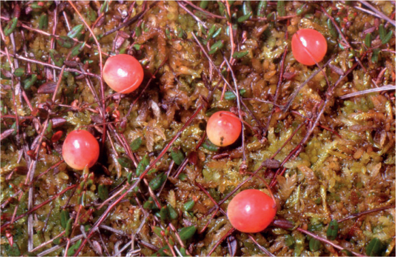
A number of minor, but very characteristic, ingredients of the ombrogenous bog flora remain to be mentioned (Fig. 208). The round-leaved sundew is common in the Sphagnum carpet in a zone between the hummocks (too competitive) and the pools (too wet); catching and digesting small insects supplements its intake of limiting N and P. Great sundew is a bog-pool plant, much more local and a much more efficient fly trap. Two pretty ericaceous plants, much smaller than the heathers and particularly characteristic of bogs, are bog rosemary and cranberry. Bog rosemary straggles among the other bog plants, its leaves recalling rosemary but broader; the flowers are like those of cross-leaved heath but much larger, borne singly and a more delicate shade of pink. The fine thread-like stems of cranberry with their half-centimetre-long leathery leaves ramify over the surface of the Sphagnum; they bear small pink flowers with recurved petals (like tiny Cyclamen flowers), which in late summer ripen to produce red-flushed cranberries, surprisingly large for the size of the plant (Fig. 209). One of the most colourful plants of our bog flora is bog asphodel (Narthecium ossifragum), with small iris-like leaves and spikes of bright yellow flowers at midsummer followed by orange seed capsules (Fig. 230f). In western Sweden it is generally regarded as an indicator of mineral-influenced conditions, but that is not true over most of its British and Irish range, or in blanket bog in western Norway. Lastly, the instantly recognisable white beak-sedge (Rhynchospora alba, Fig. 230c) is a plant of wet hollows and bog pools and can be abundant where at occurs, but wide tracts of drier bog (including most of the Pennines) are without it.
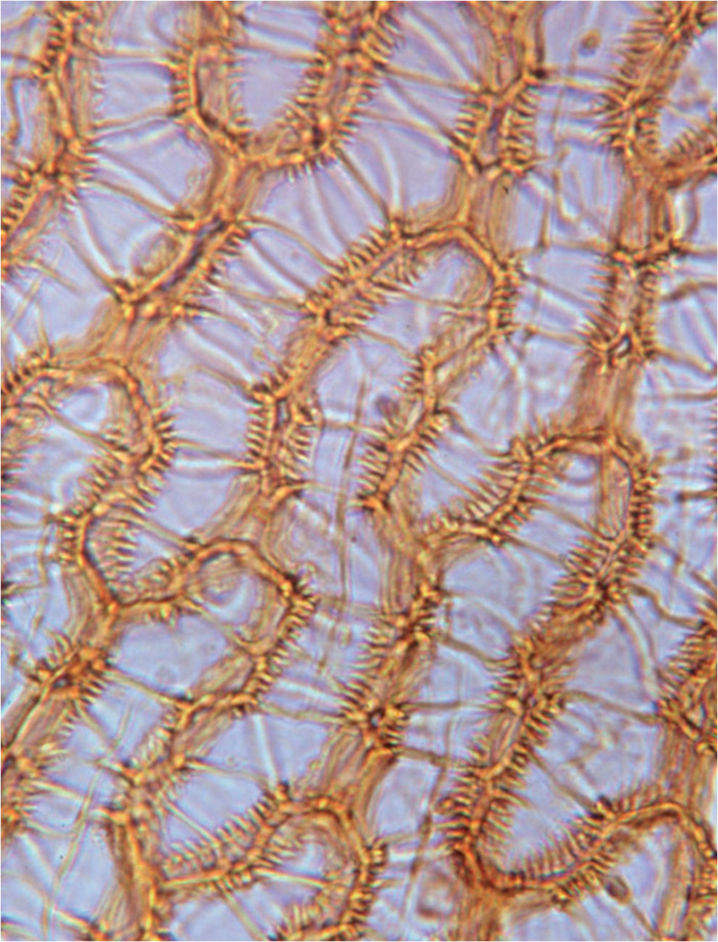
FIG 207. Leaf cells of Sphagnum austinii (S. imbricatum ssp. austinii) from peat, showing the characteristic ‘comb fibrils’ on the inner surface of the empty hyaline cells. This species was the dominant peat-former in raised bogs, but has declined greatly in recent centuries.
FIG 208. Ombrogenous bog plants: (a) round-leaved sundew (Drosera rotundifolia), the commonest sundew in bogs and wet heaths; the tiny white flowers open only in bright sunshine; (b) great sundew (Drosera anglica), in hollows and around pools in bogs, despite its name much commoner in Scotland and Ireland than in England; (c) bog rosemary (Andromeda polifolia), characteristic of lowland raised bogs; (d) cranberry (Vaccinium oxycoccos), often common creeping over Sphagnum, but rare in the south, the far west of Ireland and the north of Scotland.
FIG 209. Cranberries, Helwith Moss, Yorkshire. The berries in late summer look absurdly large for the small leathery leaves and slender wiry stems creeping over the Sphagnum.
RAIN-FED BOGS: THE SUPPLY OF WATER AND MINERAL NUTRIENTS
Rainwater is a meagre source of nutriment for plants, but it is not pure distilled water. The substances dissolved in rainwater come from three sources: sea-spray entrained as winds sweep over the ocean, dust of terrestrial origin, and gases absorbed from the atmosphere (CO2, ammonia, and oxides of sulphur and nitrogen). The proportions of these three, and with them the overall chemical composition of rainwater, varies greatly from day to day, and its average over the year varies with distance from the sea and the nature of the surrounding landscape (Table 9). There are some additional airborne inputs to the bog surface, in the form of dry-deposited dust and gases from the air, and there is some interchange of nutrients in movements of animals (farm stock, deer, birds, insects) onto and off the bog.
The peat of the bog surface is an efficient cation-exchange material and, volume for volume, holds far more solutes than the water in contact with it. Therefore the water in pools on the bog surface (and permeating the peat), in effect averages the chemical composition of the rainwater (etc.) deposited on the bog surface over a period of time – somewhat concentrated by evaporation. In the long term (years, centuries), the average composition of the rain determines the composition of the peat. In the short term (days, weeks) the peat is the major determinant of the composition of the surface water. Geographical variation in the composition of bog waters reflects these factors (Fig. 210 and Table 10).
Typically, the composition of the surface water varies somewhat round the year, with pH some 0.2 units lower, and the common metallic cations (Na+, Mg2+, Ca2+) somewhat higher, in summer than in winter. Summer droughts can cause ‘spikes’ of acidity through the oxidation of H2S to H2SO4 as the water level falls and the peat aerates. The clearest periodicity of all is shown by the brown ‘peaty’ colour due to dissolved organic matter, most intense in summer.
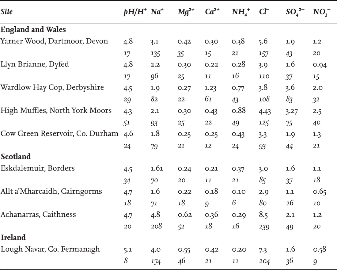
TABLE 9. Average chemical composition of rainwater at some sites in Britain and Ireland, 1986–98 (data of Hayman et al. 2000). The table includes the major ions except potassium (K+), which is present in very low concentrations (c. 0.1 mg/litre = c. 3 µmol/litre). Figures in roman type are mg/litre; figures in italics are µequiv/litre (µmol ionic charge/litre, generally used by environmental chemists). Yarner Wood, Achanarras and Lough Navar are relatively near exposed coasts and have high values of sodium and chloride. Wardlow Hay Cop and High Muffles are the nearest to major industrial areas, and have the lowest pH and the highest values of sulphate, nitrate and ammonium nitrogen. Wardlow Hay Cop is in a limestone area and has the highest level of calcium.
In lake or river water, the positive charges on the cations (H+, Na+, K+, Mg2+, Ca2+ etc.) are balanced by the negative charges on the inorganic anions (Cl–, SO42–, HCO3– etc.). In ombrotrophic bog waters there is typically an apparent anion deficit; part of the total cations is balanced by organic acids in the dissolved organic matter. Organic anions may commonly balance 40% or more of the total cations in the Baltic countries, around 10–30% in Britain and Ireland, while in the extreme western blanket bogs of Galway and Mayo the anion deficit is very small. The organic anions are what holds the pH of ombrotrophic bogs at around 4 (Proctor 2003, 2006, 2008).
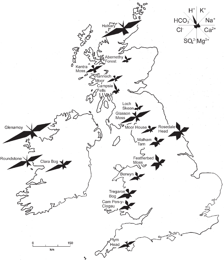
FIG 210. Maucha diagrams of the major ions on ombrogenous bogs in Britain and Ireland. Sodium (Na+) and chloride (Cl–) are generally the dominant ions in British and Irish ombrogenous-bog waters, but sulphate (SO42–) and acidity (hydrogen ion, H+) may be comparably high near industrial areas. The diagram at the centre of the key (top right) is for a bog in central Estonia, far from open ocean and from industry – the bog water is very dilute: the most abundant ions are H+, Ca2+ and SO42–. For further explanation see p. 289.
TABLE 10. Chemical composition of some bog waters in Britain and Ireland. The Malham Tarn and Plym Head data are averages of measurements from sets of six samples at monthly intervals over the five-year period 1992–98. The Mongan Bog and Roundstone data are averages from sets of samples collected in September 1997. Figures in roman type are mg/litre; figures in italics are µequiv/litre (µmol ionic charge/litre).
All plants need some essential elements in relatively large quantities, notably N, P and K. Of these, K is generally sufficient for the needs of the slow-growing bog plants. The indications are that, for bog plants, N is limiting in unpolluted environments, but that P soon becomes limiting as N deposition is raised by human activities (industry, vehicle exhausts, intensive farming etc.). Rainwater contains measurable amounts of both nitrate (NO3–) and ammonium (NH4+) ions, but very little of either is detectable in the surface water. Sphagnum uses NO3– from rain as a nitrogen source, but most of the NO3– and NH4+ in rain must be quickly taken up, perhaps mainly by microorganisms. Peat contains a lot of nitrogen, but mostly in organic forms inaccessible to most plants. The ericaceous plants with mycorrhizas acquire organic nitrogen through their symbiotic fungi, and the non-mycorrhizal hare’s-tail cottongrass may take up most of its N requirements in the form of free amino acids. Ombrotrophic bog plants clearly exploit a diversity of N sources. Phosphorus is, as so often, the scarce resource. Phosphate is often undetectable in bog waters, because the plants (and microorganisms) take it up as soon as it is released by mineralisation. Mycorrhizal plants on bogs get much or all of their P through their mycorrhizas; the roots of non-mycorrhizal species probably rely on acid phosphatases secreted by their cell surfaces to release inorganic P from organic phosphates. Water movement can be important to the nutrition of bog plants. Where drainage from the bog surface is concentrated into ‘water tracks’ the nutrients from a wide area become potentially available to plants that can take them up, and slow molecular diffusion to the root surface is supplemented by much faster mass flow of the water in the peat. This often results in much greater vigour of the vegetation – especially of dominant species such as hare’s-tail cottongrass, Molinia and black bog-rush (Schoenus nigricans) – in water tracks, and greater vigour of the rooted vascular plants relative to Sphagnum.
THE INITIATION AND GROWTH OF OMBROGENOUS PEATS
The main credit for establishing the concept of the hydrosere, with raised bog as a culminating stage, belongs to the German C. A. Weber (1902). Weber recognised, from sediments and peats in north Germany, the sequence from open water, through ‘eutrophic’ fen (Niedermoor) and ‘mesotrophic’ transitional communities (Übergangsmoor) to ‘oligotrophic’ bog (Hochmoor). His Hochmoor was translated in the contemporary British ecological literature as ‘high moor’ and caused a good deal of confusion; from the 1920s the accepted equivalent was ‘raised bog’. Weber was clear that raised bog could also develop by paludification of forest on formerly drier ground, and that this had commonly taken place.
Ombrogenous peat growth in raised bogs most often roughly coincided with the shift to a rainier, more oceanic climate at the Boreal–Atlantic transition as the North Sea basin filled, and the sea rose to near its present level, roughly 8000 years ago. The rising sea flooded low-lying coastal expanses of land in what became the Somerset Levels, the Cambridgeshire Fenland and the lowland valley of Scotland (and elsewhere), and these places had to wait for accumulation of estuarine silt and clay (and in Scotland isostatic rise) to bring the surface above sea level before hydrosere development to bog could begin. Blanket-bog growth in the uplands began locally at much the same time as the raised bogs, but in some places (such as mid Wales, Northern Ireland, and Orkney and Shetland) it appears to have started only about 4000 years ago (Tallis 1991, 1995). Some of this variation may be more apparent than real, however, reflecting our imperfect knowledge.
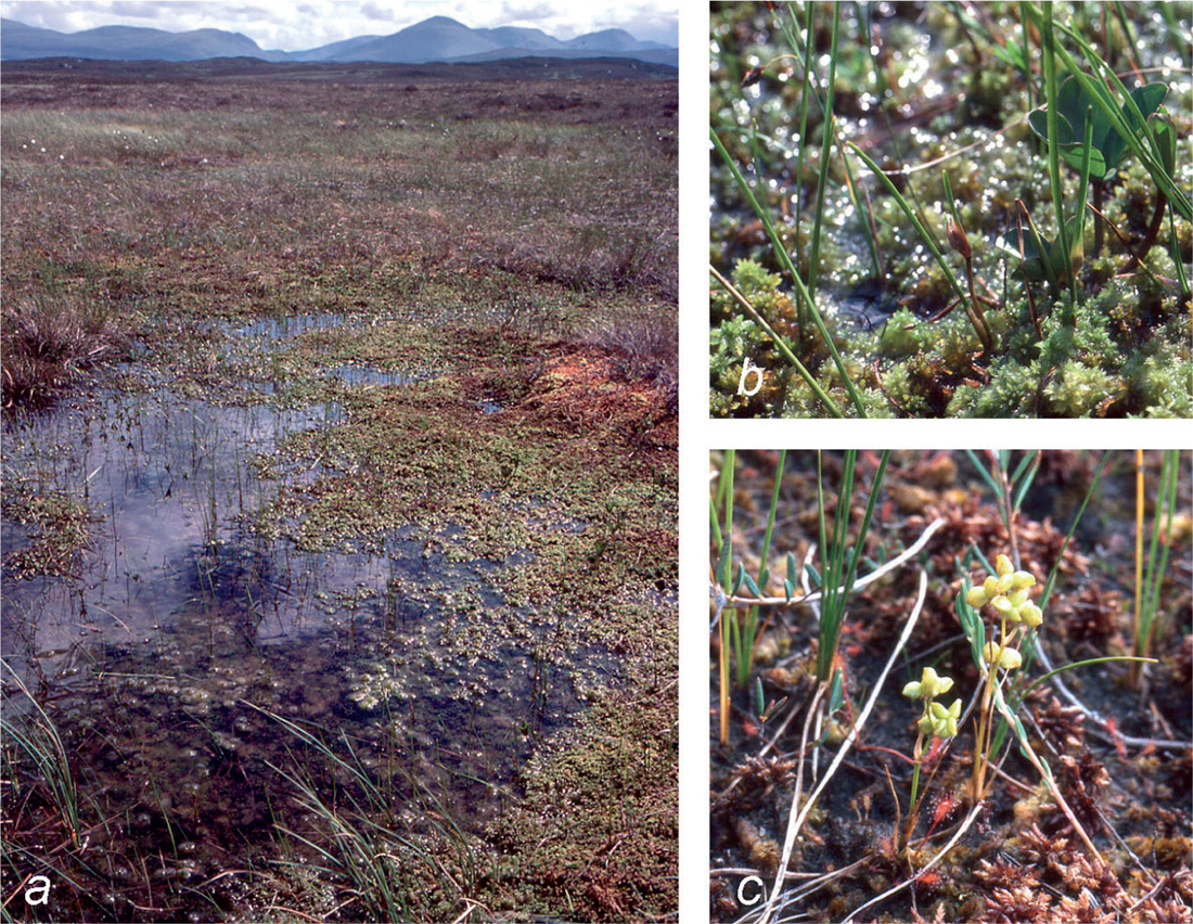
FIG 211. Rannoch rush (Scheuchzeria palustris), common in bog pools in northern Europe and formerly widespread in Britain and Ireland, but now very rare with us. (a) Habitat of Scheuchzeria at Rannoch, June 1981. (b) Scheuchzeria inflorescences just emerging, Rannoch, June 1981. (c) Plants in fruit, Pikasaare Bog, Estonia, August 1996.
The growth of raised-bog peat, once initiated, was usually rapid over the ensuing two millennia. After that, with the climate becoming warmer and drier, the rate of peat accumulation often slowed, and the peat became darker and more humified. At the ‘climatic deterioration’ around 2600 years ago, the climate became cooler and wetter again, leading to a renewal of rapid growth of little-humified peat, visible as a striking ‘recurrence surface’ (Grenzhorizont) in peat cuttings. The surface of many bogs became much wetter at this time, which is often marked in the peat by the papery remains of the rhizomes of the Rannoch rush (Scheuchzeria palustris), a common plant of bog pools in northern Europe, which now survives with us only on Rannoch Moor (Fig. 211). The wetness and flooding caused Bronze Age people to lay down brushwood trackways across the Somerset bogs, which have been unearthed over the years by peat-digging.
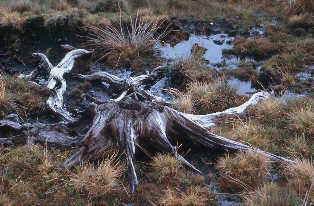
Blanket bog seems almost always to have originated by paludification of pre-existing forest, as witnessed by the stump layers that often underlie blanket peats (Fig. 212). The relative importance of climate and human activity in its initiation has been much debated. It seems likely that climate was the predisposing factor, but that felling of the forest may have hastened the paludification process, or pushed the balance in the direction of bog, especially in wet periods favourable to bog growth.
FIG 212. Pine stump exposed by erosion of blanket bog, Slieve League, Co. Donegal, September 1965.
PEAT, WATER AND THE STRUTURE AND HYDROLOGY OF OMBROGENOUS BOGS
Ombrogenous peat is a remarkable substance. Fresh peat consists of plant fragments in various stages of decay in a gelatinous matrix, and about 90% of it is water. It may be thought of as rather like porridge. A recipe given for ‘traditional oatmeal porridge’ is 60 g medium oatmeal to 570 ml water, almost the same bulk density as ombrogenous bog peat. Peat, like porridge, is rigid up to a point, but beyond that it will give way and flow. Again like porridge, peat has a surprisingly low hydraulic conductivity: water will not flow rapidly through it. Once a layer of peat has formed over the soil surface, it tends to be self-perpetuating, a factor important in the origin of ombrogenous bogs by paludification, and the persistence of bogs once formed.
The growth and accumulation of peat: acrotelm and catotelm
Bog peat is not uniform throughout. The surface 30 cm or so of an active bog, the acrotelm, is where most biological activity takes place. Almost all the seasonal (and shorter-term) fluctuation of the water-table takes place in the acrotelm, which is aerobic, and the layer in which most of the bog plants are rooted. Photosynthesis and growth of vegetation on the surface adds organic material to the acrotelm. The top part of the acrotelm consists of fresh and often recognisable plant remains, but this is broken down quite rapidly by aerobic decay. As new material is added year by year the residue becomes more resistant, less exposed to aerobic breakdown, and at the base of the acrotelm it has become peat, to be added to the catotelm, which is permanently waterlogged and anaerobic, and makes up most of the depth of the bog. The acrotelm may be thought of as a composter, fed with fresh plant material at the top, and processing it to become new catotelm peat at the bottom – or as the cooking pot to which oatmeal and water are added to make the porridge. Obviously the acrotelm is itself not uniform, and it passes insensibly into the catotelm at the bottom.
As already mentioned, catotelm peat has a very low hydraulic conductivity. The more fibrous acrotelm is much more permeable; its hydraulic conductivity is greater by a factor of 10,000 or so. Consequently, most lateral water movement – most of the radial drainage of the bog – takes place in the acrotelm. Usually, 90% or so of the organic matter produced by the vegetation is broken down in the acrotelm, leaving around 10% (or less) to be added to the store of peat; the growth-rate of an actively growing ombrogenous bog is typically 5–10 cm a century.
Anaerobic breakdown of peat and the formation of methane
Once incorporated into the catotelm, the peat is immune from further aerobic decay, but it is still subject to microbial breakdown by much slower anaerobic processes. In simple terms, this may be thought of as rearranging the atoms in carbohydrate n(CH2O) into n/2 molecules of methane (CH4) and n/2 molecules of CO2, with a modest release of energy. Methane is ‘marsh gas’, and its production is detectable in the catotelm. It rises through the peat and may escape to the atmosphere if it does not get oxidised to CO2 and water as it passes through the aerobic surface layers. Methanogenesis leads to a slow but steady loss of mass from the deep waterlogged peat (Clymo 1984). This adds a steady anaerobic loss term, dependent on the depth of the bog, to its carbon budget. Aerobic decay in the acrotelm responds to the wetness or dryness of the surface, but anaerobic decay in the catotelm does not (Belyea & Clymo 2001).
Are ombrotrophic bogs a net sink or net source of atmospheric CO2?
Globally, peatlands contain about the same amount of carbon as is present as CO2 in the atmosphere. They are the single most important terrestrial carbon store, and are critical in any discussion of rising atmospheric CO2 levels. Virtually all of the northern peatlands have grown up since the close of the last glaciation, so during that time they have been a major sink for atmospheric CO2. It is much harder to determine whether an ombrogenous bog is a net sink or source at the present day, and sufficient data to evaluate this exist for relatively few sites worldwide. The problem is that the carbon budget of a peat bog depends on the balance between various processes, all of them hard to measure accurately. Carbon can only be added to the system by the photosynthesis of the plants growing on its surface, but a large part of that carbon is lost by aerobic respiration in the acrotelm before being transformed into peat. Some carbon is lost as methane and CO2 in the catotelm, depending on its thickness. Those gains and losses take place all over the area of the bog. A substantial amount of carbon is lost as dissolved organic matter in the drainage water, to be oxidised to CO2 in streams and rivers outside the bog, and this water leaves the bog already saturated with CO2. These losses are in addition to peat lost by erosion. In Britain, the Centre for Ecology and Hydrology has research aimed at evaluating carbon budgets in four peatland catchments, at Forsinard in Sutherland, Auchencorth Moss south of Edinburgh, Moor House in the north Pennines, and in the Migneint in north Wales.
The ‘hydrological mound’
Raised bogs are domed – but what determines the height of the dome? If water falls uniformly over a porous material and can drain out freely round the edges, it forms a domed water-table, gently sloping near the middle and progressively steeper towards the edges (Ingram 1983). For the case of a circular bog draining to a lagg at uniform level, the theoretical cross-section of the bog is a half-ellipse. The highest point of the dome is proportional to the radius of the bog, and to the square root of the rainfall, and inversely proportional to the square root of the hydraulic conductivity of the (catotelm) peat. The shape of the hydrological mound is a good fit to the profile of Dun Moss in Perthshire (near-parallel sided) and Ellergower Moss in Wigtownshire (nearly circular), but many bogs are of more complex shapes that defy simple mathematical analysis.
HUMMOCKS, HOLLOWS AND BOG POOLS
Often the surface of a bog has a pattern of hummocks and hollows or pools. These have long fascinated ecologists. Osvald (1923) suggested that the pattern he observed on the bog Komosse in central Sweden could be interpreted as a cyclical succession in time, the bog-pool sphagna raising the level until vigorous hummock-building Sphagnum species could begin a rapid phase of hummock growth, brought to an end as the hummock-top became dry enough for heath shrubs and sphagna such as S. capillaceum and S. fuscum. Other hummocks were then envisaged as growing up around it, so that in due course it was flooded and became a pool once more. Sixty years ago this elegant concept of the ‘regeneration complex’ was widely accepted. It became apparent, however, that there was little evidence for it in peat sections, and at many sites abundant evidence to the contrary. Since then it has been realised that many pool systems have a substantial degree of permanence, and that hummocks and hollows tend to have a regular relationship with the topography of the peat surface. If the peat surface is flat, the outline of the pools is irregular, with no preferred direction. If the surface is sloping, the pools are oriented along the contours. Many ombrogenous bog domes throughout the Boreal zone (Scandinavia, northern Russia, Canada) show similar patterns of concentrically oriented pools and hummocks, sometimes with a larger more or less circular pool at the centre. But systems of irregular deep ‘mud-bottom’ pools are also common. Some of the best examples of surface patterning in Britain are in the Flow Country of Caithness and Sutherland (Lindsay et al. 1988; Fig. 219), but there are fine examples farther south, such as Kentra Moss (Fig. 211) and Claish Moss (Moore 1977; Fig. 213) in west Argyll and the Silver Flowe in Galloway (Boatman et al. 1981).
There can be no doubt that patterns of hummocks and hollows stem from the interaction between water movement over the bog surface, and the growth-responses of the plants (especially the Sphagnum species) to water level. A computer model (Couwenberg & Joosten 2005), making simple (and reasonable) assumptions about rainfall, the shape of the bog, the hydraulic conductivity of the peat beneath hummocks (high) and Sphagnum hollows (low), and the probability of a site at any particular water level developing into either a hollow or a hummock, generates patterns reassuringly like those we see on real bogs, and we can be confident that the initiation of pools and hummocks depends on some such process. Once formed, large pools (as distinct from wet Sphagnum hollows) tend to become long-lived features; at least some of the pools on Claish Moss appear to have persisted for 5000 years. Some patterning is discernible in most bogs, and pools and hummocks are an important element in their habitat diversity, whatever the details of their origin. Needless to say, pools, hummocks and patterning on bogs have a voluminous literature, to which Standen et al. (1998) provide some entry points.
FIG 213. (a) Claish Moss, on the southern shore of Loch Shiel (of which c. 3 km are visible), Argyll, March 2011. The wetter ombrotrophic bogs show up as dark patches against the buff shades of the Molinia and deergrass of the surroundings. (b) A closer view of part of the pool system; pools oriented roughly parallel to the contours of the bog surface, separated by ‘strings’ of bog vegetation, with islands in many of the larger pools. The light greyish patches are Racomitrium lanuginosum capping the hummocks. July 2011 (Iain Thornber).
IS THERE A LIMIT TO BOG GROWTH?
Bog bursts
The hydrological mound obviously sets a limit beyond which a bog cannot grow, but are the surface profiles of all bogs dictated by it? Almost certainly not, if only because many bogs are still growing. What other limits are there to peat growth? Peat can only grow up to the limit set by the hydrological mound if it has the mechanical strength to resist downslope movement.
A bog-burst between Falkirk and Stirling in 1629 destroyed 16 ‘little farms’. On the night of 17 November 1771 peat erupted from Solway Moss, northwest of Carlisle, flowing over 400 acres of land, drowning cattle and engulfing farms, whose occupants ‘passed a horrible night … till the morning, when their neighbours with difficulty got them out through the roof.’ In 1824 the Rev. Patrick Brontë wrote a graphic account of a bog-burst near Haworth on a thundery day: it was strong stuff for his sermon the following Sunday (Brontë 1824a, 1824b). A devastating burst in the early hours of 28 December 1896 high above the Ownacree valley, 15 km east of Killarney, inundated 300 acres (120 ha) of farmland with peat and swept away the house of Cornelius Donelly. He and his wife and six children all perished; part of one of their beds was picked up a few days later in Killarney Lake (Praeger 1897).
These are a few of the recorded bog bursts. There have been many others, most often in upland blanket bog. In some at least of these, the slide has taken place at the base of the peat, or in clay underlying it. Probably many minor bursts or ‘peat slides’ pass unrecorded, but every few years one makes at least the local headlines or for other reasons is put on record; in 2003 there were bursts in the Pennines (Teesdale), in Shetland (Channerwick) and on Slieve Aughty (Derrybrien). For more, see Tallis (2001).
Peat erosion
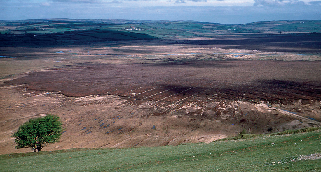
Almost all bogs have some erosion gullies at the edges, which may branch as miniature river systems. Sometimes, especially in upland blanket bogs, gully systems are a conspicuous feature of the mire surface, and in extreme cases they erode off the whole peat cover down to the mineral ground beneath, though usually leaving behind ‘haggs’ as reminders of the former bog. The southern Pennines are a classic area of peat gullying and hagging, but there are few upland peats without at least some erosion. Erosion appears to date back to prehistoric (Bronze Age) times, and may relate to the felling of woodland in the neighbouring valleys; the climate then was warmer and drier than now. The earlier gully systems were often richly branched, creating a reticulate pattern on relatively flat ground (Fig. 214); they may have originated through coalescence and draining of pool systems. Parallel deeply-incised downslope gullies seem generally to have come later in response to more direct human pressures on the bog itself. Fire, ditching, grazing and atmospheric pollution (especially during the nineteenth and earlier twentieth centuries) have probably all played a part in accelerating erosion in recent centuries. Erosion can be rapid; exposed surfaces can lose several decimetres of peat a year. Recolonisation of eroded surfaces is often slow, from a combination of lack of propagules, poor physical and nutrient conditions for germination and establishment, disturbance by grazing sheep and the harsh climate.
FIG 214. An erosion-gully system on blanket bog in the southern Pennines, Alport Moor, Derbyshire. Probably the finer branches develop first, often in relation to pre-existing hummocks and hollows, the parallel gullies on the steeper slopes developing later. (© Adrian Warren & Dae Sasitorn/www.lastrefuge.co.uk)
Many bogs have suffered neither bog bursts nor widespread erosion of the surface, so it seems there is no hard-and-fast limit to bog growth under the present climate, or in the time span since the close of the last glaciation. Bog growth slowed (and some bogs perhaps suffered a net loss of carbon?) in the warmer, drier climate of the Bronze Age, but picked up again as the climate once more became cooler and wetter. Tantalisingly we lack fossil evidence from previous interglacials, which might give us some insight into the question. Seemingly, our northern peatlands, which bulk so large in the present landscape, are evanescent on a geological timescale!
Fire
Perhaps surprisingly, bogs are prone to fire. Even when the peat is saturated, Calluna and the dead previous summer’s growth of Eriophorum and Molinia burn easily in dry weather. Fires under these conditions may do little lasting damage, especially if they take place in winter. Much more damaging are fires in summer droughts. If the surface layers of the acrotelm are dry enough to burn, fire can leave the bog a scene of blackened desolation. Nevertheless, the following season can bring a surprising degree of recovery. Most of the bog plants are perennials that can re-grow from underground parts, wetter spots in the hollows provide refuges for others, and Sphagnum can regenerate from living tissue at several centimetres depth even if the surface growth is killed. Really deep burns in severe droughts can result in the acrotelm being destroyed over wide areas, leaving a charred surface, hard to wet, and covered in ash (Fig. 215). The surface of the catotelm peat may dry out and crack irreversibly. Recovery from a severe fire like this is measured in decades. The earliest colonists are bryophytes, usually culminating after a year of two in a dense carpet of the moss Polytrichum commune, into which rushes (mainly Juncus effusus) and grasses become established. Full return to normal bog vegetation takes maybe a century or two. Polytrichum layers are not uncommon in peat sections, and in most cases probably indicate a fire episode. Bogs can recover from occasional fires, but no bog can survive frequent burning with its vegetation intact.
FIG 215. Effects of severe fire on North York Moors blanket peats. (a) Rosedale Head, October 1983, seven years after the severe fires of the dry summer of 1976. The moss Polytrichum commune covers wide areas of peat. Early hair-grass (Aira praecox) picks out areas of sandy mineral soil, and soft-rush (Juncus effusus) colonises moist hollows and runnels, but much bare peat remains. (b) Cockheads, 1986 burn site, February 1987. The peat surface is deeply charred, cracked and permeated with tarry material from the burnt peat above. Ash has accumulated in the hollows. Burnt heather in the foreground.
Peat digging, peat exploitation
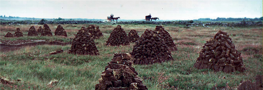
‘Do you not burn turf in England?’ asked Mrs Carey in reply to my compliment on her welcoming peat fire. ‘Well, what do you burn then? Isn’t coal terribly expensive? … And to think of it, when you can just take a donkey out on the bog, and cut as much turf as you like.’ That was Co. Clare in 1953. In the 1950s many men were digging turf from the bog south of Lisdoonvarna and in the bogs west of Screeb in Connemara. There were traditional turf stacks everywhere (Fig. 216). A 1957 estimate put the annual production of hand-won peat in Ireland at about 3,500,000 tons.
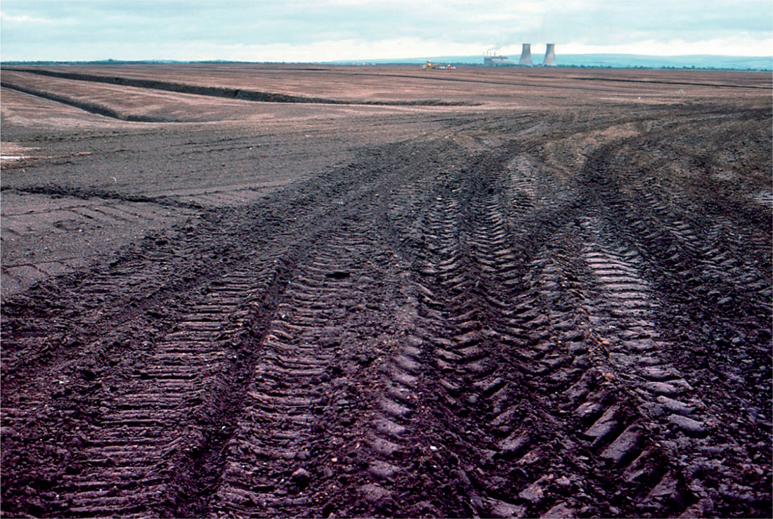
Ireland has changed a lot since then. Most of the big midland raised bogs have been cut away for peat, primarily to fuel peat-fired power stations, and for industrial and commercial use. Modern industrial peat extraction is highly mechanised (Fig. 217). Following drainage and stripping of the vegetation the surface peat is milled, harrowed, ridged and harvested. This sequence takes about three days, by which time moisture content has fallen to 50–55%. It can be used for power generation straightaway, but for industrial or domestic use it is dried further, to a moisture content of about 14%. Small-scale peat extraction has changed too. Many farmers now have ‘sausage machines’, which, drawn behind a tractor across a bog (grazed and compacted by livestock), cut a cylinder of peat below the root mat and extrude it onto the surface to dry. Small mechanical diggers are within the means of many. Some of their owners expect the same freedom to win turf as in the days when there was no alternative to a spade and muscle-power!
FIG 216. Stacked turf ready for carting. Rinroe, near Corrofin, Co. Clare, July 1959.
FIG 217. Mechanised peat extraction, near Cloghan, Co. Offaly, September 1988. The chimneys and cooling towers of the Shannonbridge peat-fired power station can be seen in the distance; the peat-milling machinery can just be made out to the left of the power station. Many sites like this are now derelict and overgrown with birch, sallow and other vegetation.
LOWLAND RAISED BOGS
In many respects the lowland raised bogs of Britain and Ireland are rather uniform, and the outline earlier in this chapter gives a pretty fair idea of the flora and vegetation of them allM18. Probably the best in Britain, judged in terms of their vegetation, are Glasson Moss (250 ha) and Wedholme Flow (270 ha), south of the Solway some 20 km west of Carlisle, but because they stand as islands in a farmed landscape and parts have been extensively exploited for peat it is not easy to appreciate their geographical context. Cors Caron (800 ha), in the Teifi valley in mid Wales is a fine group of three raised bogs set in meanders of the river. They have been cut for peat at the edges in the past, but their outlines and context are essentially intact, and they are beautiful textbook examples of the relation of raised bogs to their surroundings (Fig. 218). The river is bordered on either side by a belt of silted fen abutting on the steep rand of the bog. The rand on the landward side of the three bogs slopes gradually to a lagg fen separating the bog from the farmland on mineral soil beyond. Much of the surface of the bogs is rather dry and dominated by heather and hare’s-tail cottongrass, but there are substantial areas of typical pool-and-hummock raised-bog vegetation.
FIG 218. Tregaron Bog, May 1955. The River Teifi can just be seen in the middle distance. The warm straw colour of the dead leaves of Molinia is prominent in the lagg, paler where it is especially luxuriant.
A nice example of a raised bog in its context is Malham Tarn Moss (c. 30 ha) in the Yorkshire Pennines (Fig. 199). Before the Tarn Moss was acquired by the National Trust in the 1940s it had been heavily (and probably frequently) burnt; it was dominated by tussocky hare’s-tail cottongrass, with wavy hair-grass (Deschampsia flexuosa) as the only common associate – apart from the mosses Pohlia nutans and Tetraphis pellucida, both common after burning. Since then, the bog has had 60 years to recover; there is now a good scatter of Sphagnum rubellum and S. papillosum, and most of the characteristic raised-bog species can be found somewhere, but the vegetation has a long way to go to match Tregaron or the Cumbrian mosses. As so often in Britain, Sphagnum austinii no longer grows on the bog surface at either site, although its highly recognisable remains make up the bulk of the peat at both. There are still many small raised bogs scattered round the north and west of Britain, particularly in Scotland.
The raised bogs of the midland plain of Ireland are more extensive than any that remain in Britain. The Irish Peatland Conservation Council listed 101 ‘active raised bogs of European conservation importance’ of 100 ha or more, and many smaller (2000). The largest are in Roscommon, Galway and Offaly. Clara Bog, some 10 km northwest of Tullamore, is an impressively large (665 ha) expanse of raised bog south of Clara town (Fig. 201). Mongan Bog, near Clonmacnoise, is smaller (136 ha) but another good example. Both are nature reserves.
NORTHERN AND WESTERN BLANKET BOGS
Scottish bogs: the Flow Country
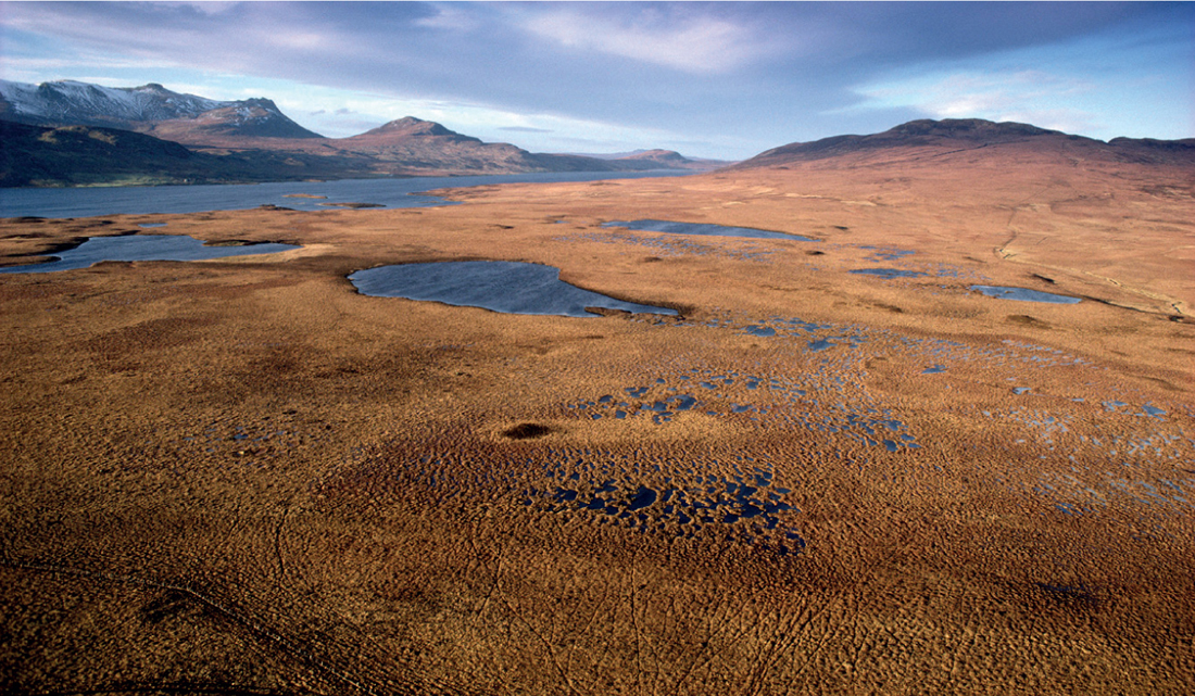
The Flow Country of Caithness and Sutherland is one of the wonders of the Scotland’s natural heritage (Figs 219, 220). The vastness of the peat-covered terrain, broken only by a few roads, a railway, a few isolated dwellings and other buildings and occasional low rounded hills, which give a view of the patterns of the dark pools strewn over the bog, is not to everyone’s taste, but for some it is addictive. There are many bogs, with magnificent pool systems. In terms of flora and vegetation the bog in the east of the Flow Country has much in common with the lowland raised bogs farther south: Sphagnum austinii and S. fuscum are locally frequent, and Racomitrium lanuginosum often caps the hummocks. Molinia, rare in the east, becomes commoner westward, along with the big purplish leafy liverwort Pleurozia purpurea. Shallow pools are dominated by Sphagnum cuspidatum, locally with S. pulchrum, white beak-sedge, great sundew (Drosera anglica) and bog-sedge (Carex limosa). Deeper pools support scattered bogbean (Menyanthes trifoliata), common cottongrass and loose masses of Sphagnum, mainly S. cuspidatum in the east, S. denticulatum becoming predominant in the west, sometimes with greater bladderwort (Utricularia vulgaris). The peatlands of Lewis are in effect an extension of the Flow Country westwards (Goode & Lindsay 1979).
FIG 219. Towards the western end of the Flow Country, the great stretch of blanket bog that covers much of the far north of Scotland, looking towards Loch Loyal in Sutherland. The crests of the ombrogenous domes are dotted with bog pools. (Steve Moore/SNH).
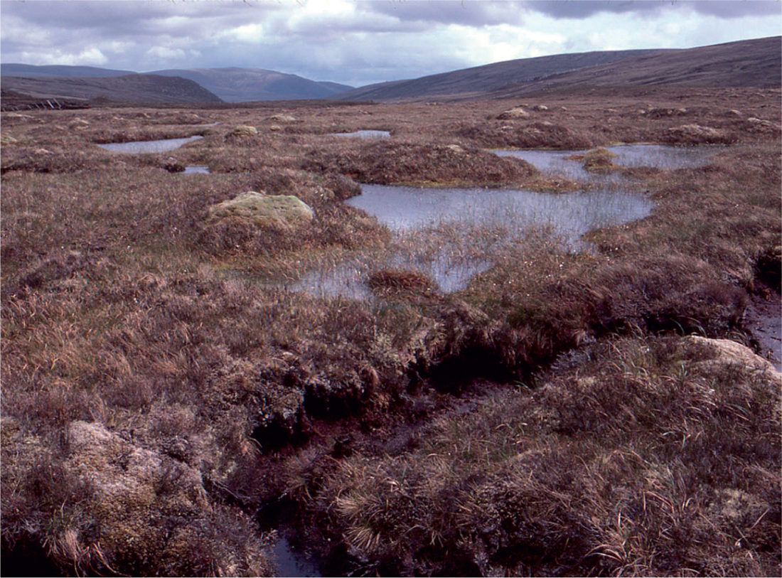
FIG 220. Deep pools with black peaty bottoms and sharp vertical sides – dubh lochan (‘little black lake’), Halsary, near Forsinard, Sutherland. Bogbean (Menyanthes trifoliata) abundant in the pools, many of which are ringed by flourishing deergrass (Trichophorum cespitosum) and bog asphodel (Narthecium ossifragum). September 1989.
The Moor of Rannoch
Rannoch Moor is an undulating area of desolate moorland and bog, around 360 m above sea level, ringed by mountains and covering over 250 km2 almost in the centre of Scotland, with the Perthshire mountains to the east and Glencoe to the west. The vegetation is diverse, broken up by the irregular terrain; it includes areas of ombrogenous bog, with minerotrophic ‘poor-fen’ areas (with interesting floras) in between, and numerous lakes. The bog is generally dominated by deergrass, hare’s-tail cottongrass and heather, with abundant MoliniaM17, great sundew, the moss Racomitrium lanuginosum and Pleurozia purpurea. Locally there are well-developed bog-pools, the habitat of the plant for which the moor is best known, the Rannoch rush. The bogs support abundant sphagna, including S. austinii and S. fuscum.
Western Scottish bogs
Ombrogenous bog is never far away in north and west Scotland, but three bogs stand out. In Argyll, Claish Moss on the south shore of Loch Shiel (Fig. 213) is a gently sloping bog with magnificent pool systems and a rich bog flora. Deergrass, hare’s-tail cottongrass, heather and Molinia are dominantM17, as usual in west Scotland. Other notable features include conspicuous Racomitrium-capped hummocks, and the common occurrence of brown beak-sedge (Rhynchospora fusca), bog-sedge, Sphagnum pulchrum and Pleurozia purpurea. Kentra Moss, west of Acharacle, shares many features with Claish Moss and is more accessible but has suffered more disturbance and damage. However, its southern parts still bear fine bog vegetation and splendid systems of narrow pools oriented along the contours of the gently sloping surface (Fig. 211). The Silver Flowe (Kirkcurbrightshire, 190 ha) is a chain of six more or less discrete patterned bogs on the floor of a glacial valley in the Galloway hills (Ratcliffe & Walker 1958; Boatman 1983). The southernmost major western blanket-bog site in Scotland, it is a fascinating area, offering analogies not only with the bogs of the Flow Country and other northern and western Scottish bogs, but with classic lowland raised-bog domes, and with the extensive upland blanket bogs. It is a lovely place, but could be the despair of category-minded people who seek to impose sharp boundaries on nature!
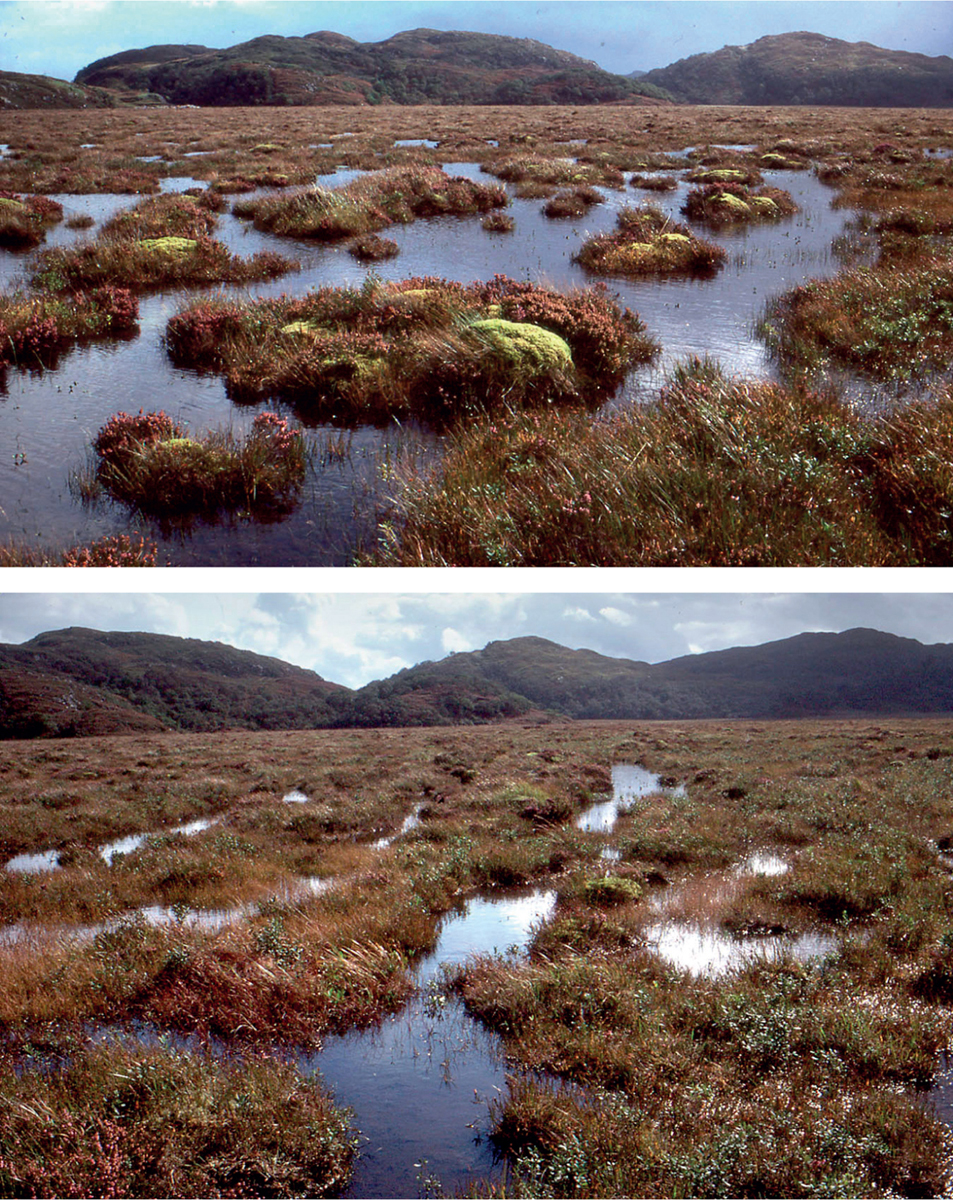
FIG 221. Kentra Moss, Ardnamurchan, Argyll. A western Scottish bog sloping gently east towards Acharacle, with a well-developed pool system. (Top) A flattish area with large pools containing numerous islands, many topped with the moss Racomitrium lanuginosum. (Bottom) A gently sloping part of the bog with long pools oriented along the contours; in the left foreground is a ‘spillway’ from one tier of pools to the next. Molinia and cottongrasses are abundant, and there is a rich bog flora, including brown beak-sedge (Rhynchospora fusca), bog-sedge (Carex limosa), sundews (Drosera spp.) and various bladderworts (Utricularia spp.).
Western Irish lowland blanket bogs
In a region of near-ubiquitous blanket bog two areas stand out as classic sites: the bog between Roundstone, Ballyconneely and the Twelve Bens in Galway, and the bog around Glenamoy in northwest Mayo. The Roundstone bog has perhaps unfairly dominated our perception of western Irish bogs in general. The area is a lake-studded stretch of rocky undulating country covering some 7000 ha. Rather like Rannoch Moor, it is occupied by expanses of ombrogenous bog with mineral-influenced tracts of ‘poor-fen’ in between, and relatively dry heather and western gorse (Ulex gallii) on rocky knolls. Molinia and Schoenus nigricans are abundant almost everywhere, including areas that water analyses (and topography) show to be indisputably ombrotrophic. In species composition, the bog has much in common with the western Scottish bogs. Hare’s-tail cottongrass and deergrass are usually present but seldom prominent in the plant cover. Most of the species that characteristically become commoner towards the west in Scottish bogs, such as Pleurozia purpurea, and bog-sedge, bladderworts (Utricularia spp.), and Sphagnum denticulatum in the pools, are in the western Irish bogs as well – with the addition of pipewort (which is in the Hebrides and just makes the Scottish mainland in Ardnamurchan). East of the Roundstone bog, there are wide tracts of blanket bog on the Connemara granite still with abundant Schoenus and Molinia, but looking much more like blanket bog elsewhere in western Britain or Ireland.
By contrast with many of the western Scottish bogs, the lowland blanket bogs of west Galway and Mayo are relatively flat. Nowhere is that more evident than in northwest Mayo, where seemingly featureless bog often stretches as far as the eye can see. The bog north of Glenamoy (nearly 5800 ha) was chosen as the site of the Irish project for the International Biological Programme in the 1960s. The Mayo bog is much less broken up by lakes than the Roundstone bog, so it is less confusing, less scenic, but it dramatically expresses how monotonously vast blanket-bog landscapes can be. There are substantial areas of lowland blanket bog in Donegal, and some in Kerry (Fig. 212), but there the mountains leave little flat land at low levels. However, the extent of turbaries on low ground around Ballinskelligs Bay and elsewhere shows that lowland bog was once widespread.
FIG 222. Blanket bog at c. 150 m near Kealboy Bridge, northeast of Ballaghisheen, Co. Kerry, looking towards Macgillycuddy’s Reeks. Abundant Molinia, common cottongrass (Eriophorum angustifolium), black bog-rush (Schoenus nigricans) and sundews. As in many western bogs, Sphagnum is pervasive and hare’s-tail cottongrass is widely scattered but neither is prominent. Large-flowered butterwort (Pinguicula grandiflora) present, but rare. June 2010.
MOUNTAIN BLANKET BOGS
Upland blanket bogsM19 cover many gently domed or undulating plateaux in Wales and the Pennines, the Southern Uplands of Scotland and the eastern, central and northern Highlands. Typically they are composed largely of ‘hummock’ species – Calluna, Erica tetralix (less frequent northwards, often absent above 600 m), Eriophorum vaginatum and the ubiquitous E. angustifolium; the more northern Sphagnum capillifolium commonly replaces the more oceanic S. rubellum, and true mosses such as Pleurozium schreberi, Dicranum scoparium and Hypnum jutlandicum are prominent; Sphagnum papillosum, though usually present, is much less conspicuous than in lowland bogs. The heathers are often accompanied by crowberry (Empetrum nigrum), bilberry (Vaccinium myrtillus), cowberry (V. vitis-idaea) and in the north by bog bilberry (V. uliginosum). A plant particularly characteristic of these bogs is cloudberry (Rubus chamaemorus), and in the Highlands mountain blanket bogs are a frequent habitat for dwarf birch (Betula nana) and arctic bearberry (Arctostaphylos alpinus). There are good areas of upland blanket bog in the Berwyns in North Wales, around upper Teesdale in the Pennines, above the Grey Mare’s Tail (northeast of Moffat) in the Southern Uplands, at many places in the Highlands (Fig. 223) and on many of the gentler mountain slopes and flatter summits in Ireland. It is one of our widespread vegetation types. Pool systems can develop over flatter summits and spurs, and the vegetation then provides a similar range of habitats to lowland bogs.
FIG 223. Upland blanket bog on saddle below Carn Chuinneag, some 20 km north of Dingwall, June 1981. A northeast Highland bog of rather montane character, with scattered dwarf birch (Betula nana) and abundant Racomitrium lanuginosum on the tops of the hummocks.
Towards the west coast, mountain blanket bog takes on some of the same character as lowland bogs in the same area, notably the abundance of Molinia. Thus, much of the bog at 450–550 m on Dartmoor is an impoverished version of ‘western blanket bog’ rather than the typical ‘mountain blanket bog’ of high ground farther north and east, and the same is largely true of the bogs on the western mountains of Ireland.
BOUNDARIES AND TRENDS: SOME CONCLUDING COMMENTS
Ombrogenous bogs are a remarkable ecological phenomenon. No wonder Scandinavian ecologists see the primary division of peatlands as (ombrogenous) bogs versus the rest! Yet they are frustratingly hard to pin down. They tend to look recognisably the same wherever they occur, but their boundary in terms of species composition varies from place to place; they are defined in practice by the species that do not grow on them. Water chemistry is no more help; the exact composition of their waters is everywhere different, and they overlap in pH, Ca and any other ions with acid minerotrophic vegetation that Scandinavians would call ‘poor-fens’. The crucial test is whether they have the independence to ‘live on air’ (and what it brings) and to grow and accumulate peat indefinitely without regard to the surrounding vegetation and soils. In Estonia or Sweden ombrogenous bogs have a short and exclusive species list. In Britain some of the Boreal ericaceous dwarf shrubs are missing, but the regular bog flora includes Sphagnum papillosum, common cottongrass and bog asphodel, all regarded as ‘poor-fen’ indicators in Sweden. In oceanic parts of Britain and Ireland Molinia is added to the regular ombrogenous bog flora, and in westernmost Ireland, Schoenus joins that exclusive assemblage. What else changes? Most conspicuously, winter temperature, and the length of time the peat is too cold for microbial activity; the anion deficit and no doubt other things show parallel changes. All these are continuous trends, within which we cannot draw any natural boundaries. The differences between ‘raised bogs’M18 and ‘blanket bogs’ and between ‘mountain blanket bog’M19 and ‘western blanket bog’M17 are clear enough (and useful) as long as you look only at their more extensive and typical sites. But there are exceptions and intermediates, and it is in fact impossible to define rigorously any of the categories or to specify boundaries between them. Probably Weber would have just called them all Hochmoor. Precisely defined categories, and the labels that go with them, are beloved (and needed) by lawyers and administrators, but they do not exist in the real world. We should not be beguiled by them. Entia non praeter necessitatem multiplicanda sunt!